1. Introduction
The severe drought years of the 1970s and 1980s drew a great deal of attention to the Sahelian region from the public media and the donor community. The awareness fueled and accelerated interest in research activities aimed at exploring human-environment interactions and the sustainability of natural resource management strategies [
1,
2,
3,
4,
5]. Notably, a number of ‘narratives’ have developed into established truths beyond need of further documentation [
6]. These include, for example, vicious circles of land degradation, prompted by population pressure and low rainfall, leading to excessive expansion of fields onto marginal land, which, in turn, leads to irreversible degradation of the natural resource base, lower productivity, and the need for larger areas to sustain the population [
7]. Recent literature, however, also underlines the importance of looking critically at received wisdom in order to avoid simplifications or misinterpretation of the processes of land use changes and their likely future directions [
8,
9,
10].
A robust, region wide characterization of the land use systems in the Sahel and of the dynamic changes has been difficult to establish, not least because of the lack of reliable, site-specific information on land use and key driving forces of land use change. Raynaut [
2] presented a very comprehensive account of the state of knowledge following especially the French research in the region up until the late 1980s. Later, some attempts have been made to employ available statistics to draw an approximate map of land use [
11] or to make a dynamic model of land use changes in the Sahel [
12]. In spite of the limited empirical material at hand, firm statements about the directions of change in land use have frequently been put forward in policy documents (e.g., [
13]) as well as in the scientific literature (e.g., [
8,
14,
15]). Yet, in fact, the entire body of literature that empirically documents land use and cropland patterns and changes to them has proven to be very limited (as documented in a meta-study by VanVliet [
16]). This gap in knowledge deserves attention because insight, solidly anchored in empirical documentation, seems crucial to assess the vulnerability and potential coping mechanisms of people living on the desert margins, and, in turn, to provide a platform for policy decisions, which take into account the exposure of local livelihoods to accelerated globalization, population pressure, and climate change.
Niger is remarkable among the Sahelian countries because of its position as the country with the highest fertility rate in the world, with an annual growth rate of 3.6 percent and a total fertility rate of 7.6 births per woman [
17]. The population forecast for the year 2025 amounts to 26 million people, compared to 16.5 million in 2011. Agriculture is hugely important in the livelihood portfolio, engaging more than 80% of the population. Rain-fed agriculture and pastoralism are the most prominent activities, highly constrained by the limited and variable amounts of rainfall. The predictions of rainfall trends are uncertain [
18]. The overall climate trends, as explored by Funk
et al. [
17], are that rainfall has increased; yet, as opposed to the era before 1970, more rain has in recent years also been associated with higher temperatures. This trend is ascribed to the influence of the Atlantic Ocean surface temperatures as well as to greenhouse gas emissions. The growing demand for food that accompanies population growth has been reflected in agricultural expansion [
17]. Cultivation potentials are mainly influenced by rainfall. As rainfall has increased, the small fraction of land suitable for cultivation has become larger. However, as pointed out by Funk
et al. [
17], supported by figures from the 1990s to 2000s, while farmland increased, the population increased at more than twice the speed. Hence, the rapid population growth has created a demand for food in an order of magnitude that may well outstrip possibilities for agricultural expansion. This general description of the large Nigerien territory obviously covers significant regional variations.
The study presented in this paper aims to provide a concrete, empirical contribution to support the discussion of the notions of field expansion. Accurate information is critical to support a thorough assessment of the pressure on land, and the plausible correlation between population pressure, climate change, and land expansion. It explores cropland dynamics in SE-Niger, a region that has received very little attention in the scientific literature. It is guided by three major questions: (a) what are the main local-to-regional trends in cropland change over the thirty years studied? (b) how does the incentive to expand cropland correspond to population increase or climate change? In addition, (c) how does satellite-based documentation of land use change correspond to local peoples’ immediate cognition? To answer these questions we employ a composite of qualitative and quantitative methods and data sources, including satellite-based mapping, statistical data, and insight gained from interviews in local communities.
2. The Conceptual Lenses of the Study
Regional population pressure, state politics, market incentives, climate variations, and access to land and water resources are acknowledged factors determining the trajectory of land use change [
19]. What is missing is a means to link these explanations to an overall understanding of the process that leads to transformation [
20].
Hence, land change science [
21] has increasingly focused on the dynamics of coupled human-environmental systems in order to account for environmental factors, social factors, and feedbacks at different spatial and temporal scales as driving forces of land use change (e.g., [
22,
23,
24,
25,
26,
27,
28]). On the one hand, the legacy of a range of classical theoretical works on rural populations’ adaptability to exogenous and endogenous stressors such as changes in the availability of natural resources, population pressure, or available technologies is appreciated (e.g., [
29,
30,
31,
32]). On the other hand, the value of a broader conceptualization to account for additional perspectives related to rapidly increasing global market integration, globalization, and climatic changes is acknowledged [
33].
The present study does not pretend to implement a rigorous theoretical framework to our study of land use and land cover changes in Niger. This is beyond the scope of our modest ambition to show contemporary trends in land cover changes and discuss the value of different methods to document these changes. Our reflections rest, however, on an analytical mindset, which draws upon a set of acknowledged conceptual lenses in a heuristic fashion: land change science [
21,
34,
35], land transitions [
14,
36], the double exposure notion [
37,
38], and coupled human-environmental timelines [
39,
40]. These lenses contribute to directing attention to pertinent issues of the land change process [
41] and provide the larger context in which land use and land cover information is crucial.
Firstly, the mindset proposed by
land change science [
14,
24] recognizes the pivotal role of land change in the Earth system. One partial perspective of interest is the environmental and agricultural land use history of specific places [
23]. The concept of land transitions is a prominent theme in the land change literature [
14], based on classical land use change theory [
30,
42]. The land transition concept envisages a predominantly unidirectional process of intensification and/or cropland expansion in land systems in response to locally-driven increased demands for land-based products and services. The embedded perception is that the land use change processes in a given (delimited) territory are driven by the increased demand located in the same territory. The land transition framework depicts significant land changes as linear and hypothesizes that there are a number of generalizable patterns of land use change that result from recurrent interaction between driving forces, following specific sequences of events [
24]. Such assumptions disregard the reality that, for example, new sources of local livelihoods to meet the demands of local populations can significantly alter the pathways of change. As a result, phases in the transition process can be prolonged, or even transgressed, because the need for intensification or expansion that is driven by increased demand is met elsewhere [
33].
Secondly, the notion of “
double exposure” [
37], which has been widely used in the global change community in the recent decades, is helpful to capture the accelerating complexity of changing environmental and societal conditions that local people are confronted with. It suggests, not only, that climate change and economic globalization are two among several important vulnerability factors. It stresses, also, that because the processes of climate change and economic globalization include implicit winners and losers, both processes must be considered simultaneously. It is widely acknowledged that economic, cultural, and political processes have a major influence on vulnerability and risks in marginal regions [
43,
44]. The “double exposure” lens is helpful in focusing on how socio-economic changes interact simultaneously with environmental or climatic risks to impact and feed back on the livelihoods and vulnerability of people.
Thirdly, the concept of
human-environmental timelines [
39] is helpful to explore trajectories of change by looking at the co-evolution of different driving forces playing out at different spatial scales. Simple timelines of events, main drivers of change, and resource management strategies appear to contribute significantly to clarifying the temporal dynamic interactions between humans and the environment and unveil correspondence and co-evolution between environmental conditions and socio-economic actions.
3. Materials and Methods
3.1. The Study Region
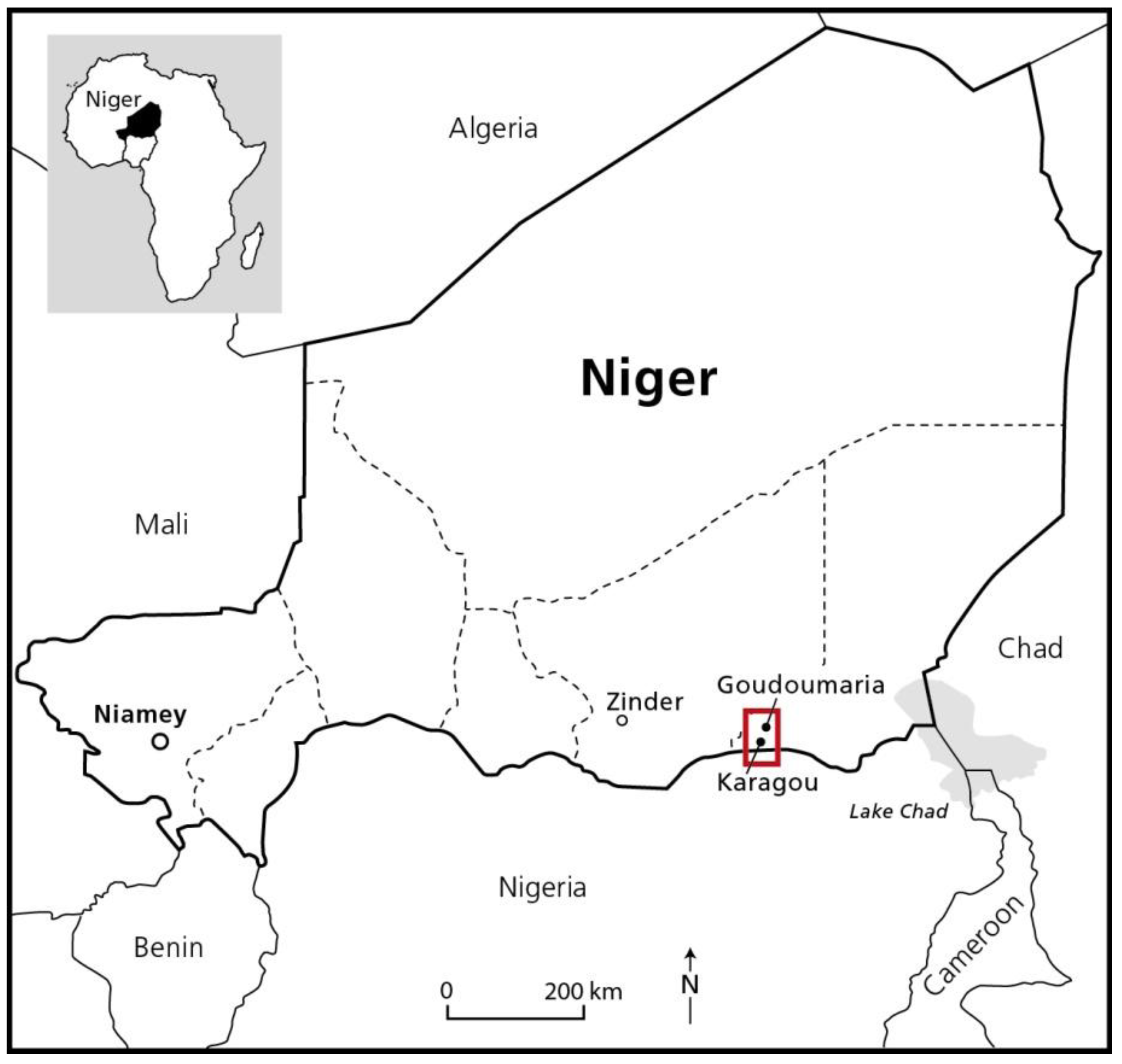
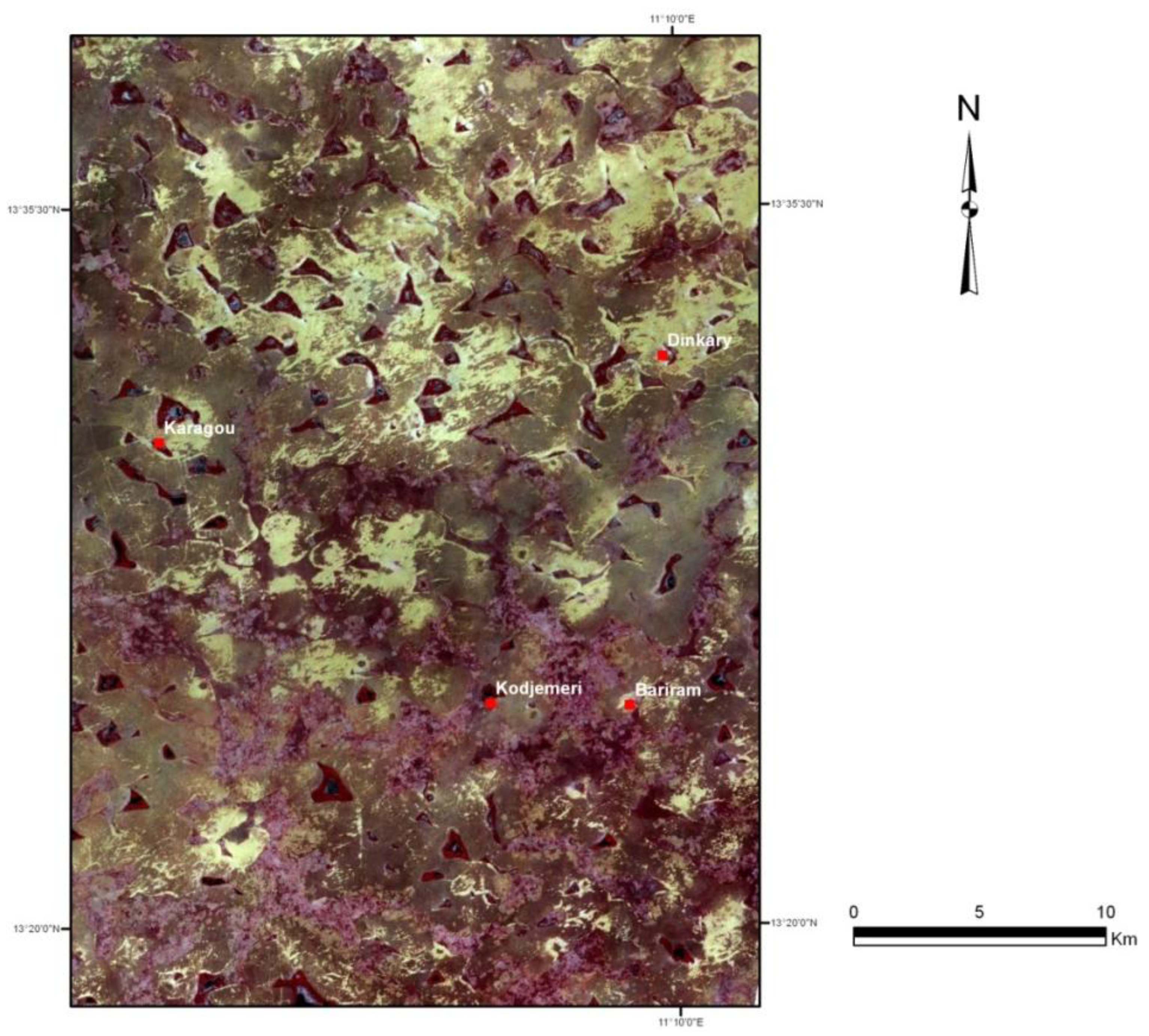
The current study focuses specifically on the region around the provincial town of Goudoumaria, which is located in Diffa province in the South-Western part of Niger, approximately 100 km to the west of the border of what has been proved to be the maximum extent of Lake Chad in a previous, more humid era [
45,
46],
Figure 1.
The landscape is dominated by large dunes originating from periods drier than the present day situation, whereas depressions (Fr.:
bas-fonds [
47]; this designation will be used in the rest of the paper for these landscape units) in the contemporary landscape originate from a hydrological network that functioned some 20,000–40,000 years ago, when the groundwater level was much higher and an accumulation of alluvial material was possible. In subsequent drier periods, aeolian erosion deepened parts of the valley system and created a large number (approximately 200) of low-lying basins (Fr.:
cuvettes; this designation will be used in the rest of the paper for these landscape units). This geomorphological history influences the soil fertility, with significant implications for the suitability of the soil for agriculture. Soils on the dunes are coarse and poor in organic matter. Soils in the bas-fonds vary from sandy calcareous to calcareous soils at the surface, superimposed upon clayey sand. The cuvette soils have high contents of salt and natron but also valuable proximity to groundwater [
47].
Figure 1.
The study region. The red frame indicates approximately the land change study region.
Figure 1.
The study region. The red frame indicates approximately the land change study region.
Rainfall is scarce and highly variable in time and space, as is characteristic for the Sahel [
48]. Although some improvement has been observed in the most recent decade, as stressed by, e.g., [
49] and [
50], the region remains highly vulnerable due to water scarcity. With an order of magnitude of around 300 mm per year, the potential for rain-fed agriculture is confined to a very limited range of crops (predominantly millet, sorghum, and cowpeas).
The traditional land use systems in the region are “typically Sahelian”, with two more or less interconnected components: (a) subsistence peasants, permanently settled in villages, who mainly cultivate millet in the bas-fonds or in the dune landscape and supplement this activity with livestock rearing; and (b) pastoralists passing through the region with their herds. The cultivators living in the villages are primarily Manga people, but some of the Peul pastoralists in the region have also become sedentary and have cultivated millet since the severe droughts of the 1970s. The agricultural potential provided by the cuvettes constitutes a unique feature for this specific region as compared to other similar drylands in the Sahel. The cuvettes are used for the cultivation of cereals and vegetables; dates are, in certain periods, also very important [
46].
For generations, the region has benefitted from being close to commercial centers in Nigeria. Imports of food, fuel, clothing, and other items have been available at attractive prices, and livestock, dairy products, and other commodities from Niger have been sold in the Nigerian markets. The new threat of terrorism from Boko Harem militants, however, forced the authorities to close the border in February 2012, with serious consequences for local people in the Diffa region, who were at the same time struggling with the challenges of a serious drought event. The cumulative effects were the doubling of millet prices and a drastic decline in livestock prices, leading to severe food insecurity [
51].
3.2. Portrait of a Local Landscape
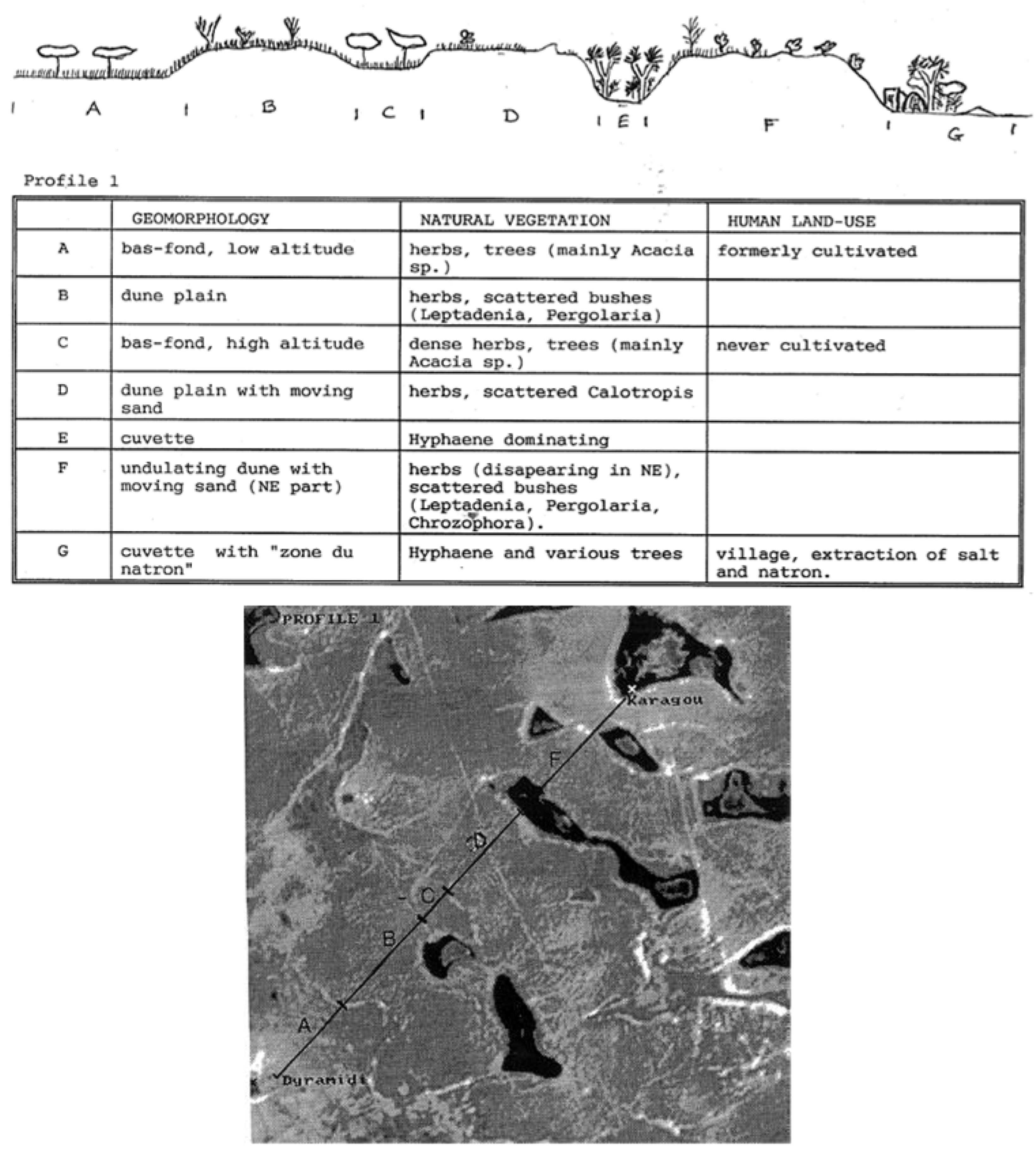
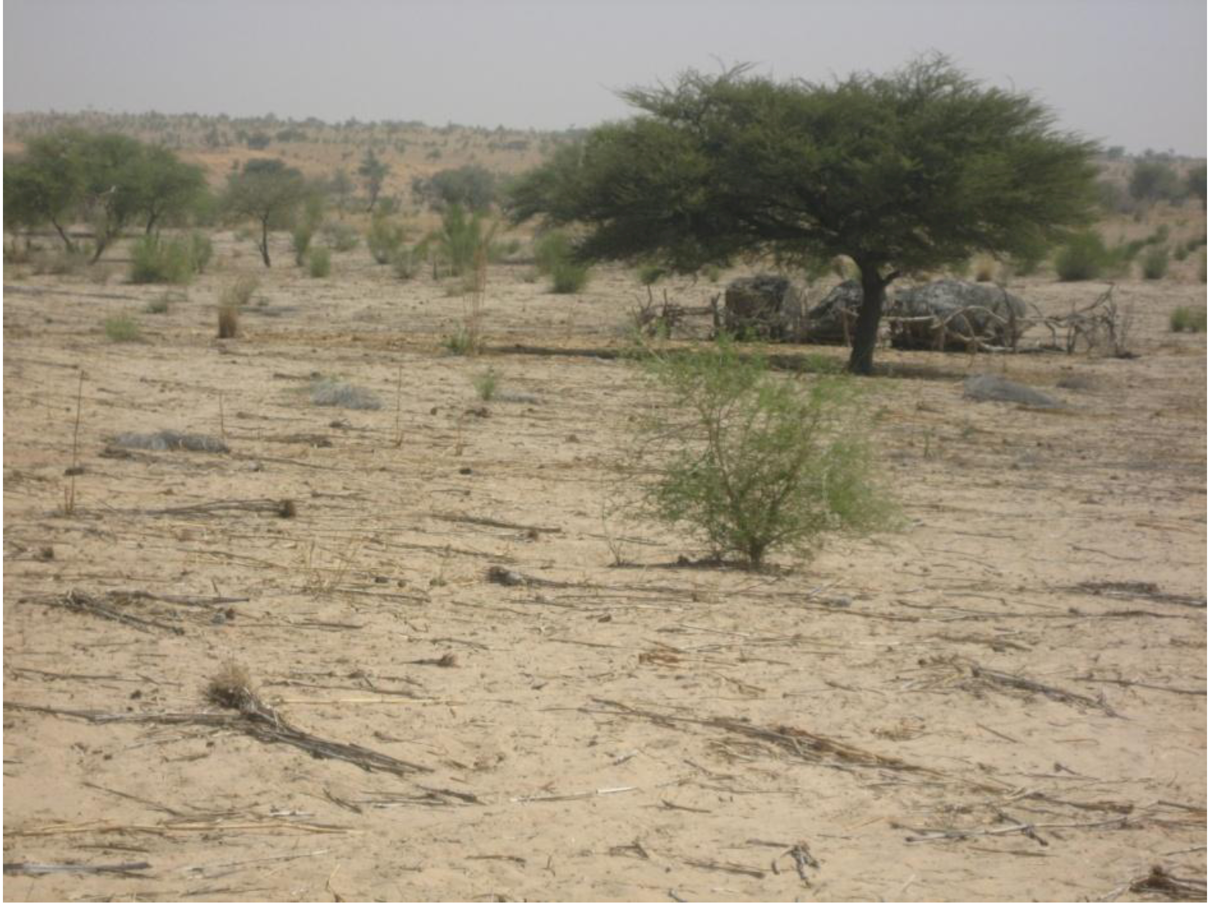
Villages in the region are different—each with their special characteristics; yet, a closer look at one of the villages from our study can serve to provide an immediate impression of the conditions for human activities in the region. Karagou is one among many villages in the dune-and-cuvette landscape in the Goudoumaria region. The landscape around this village is detailed in
Figure 2.
Figure 2.
Landscape transect around the village of Karagou, from field. None of the two bas-fond units are cultivated in this specific site, but the lowest lying (A) is formerly cultivated land. The location of the transect is indicated in the subsection of a satellite image below. Source: modified from [
47].
The potential for rain-fed agriculture is confined to a very limited range of crops (predominantly millet, sorghum, and cowpeas), which are primarily grown on fields located in the bas-fonds (
Figure 3), or in the dune landscape. The transect in
Figure 2 provides a sketch of the landscape and the agricultural use of it. As elsewhere in the region, the cuvettes (
Figure 4) are an important and productive niche in Karagou with their inherent potential for exploitation. They are used in three main ways: for agriculture, for grazing, or for a mix of the two. The use is linked to the groundwater levels of the respective cuvettes. In addition, the cuvettes are important for agroforestry products (dates and doum,
Hyphaene thebaica, in particular), and they are important for salt and natron excavation [
46]. Often, the land use is organized in concentric zones, especially in the water-rich cuvettes, where the outer part of the “halo” is occupied by palms, the next concentric zone with cereals or fruit trees, and the third with halophilic plants. Finally, in the center there is a bare surface covered with natron.
Figure 3.
Millet fields in a bas-fond (photo: Reenberg, November 2012).
Figure 3.
Millet fields in a bas-fond (photo: Reenberg, November 2012).
Figure 4.
View from the dune landscape over a “cuvette” (photo: Reenberg, November 2012).
Figure 4.
View from the dune landscape over a “cuvette” (photo: Reenberg, November 2012).
Figure 5.
Landsat image—the frame indicates the extent of the study region (Landsat, October 2005).
Figure 5.
Landsat image—the frame indicates the extent of the study region (Landsat, October 2005).
The land use in the cuvettes has shifted over the course of time and varies somewhat from one cuvette to another. When Karagou was founded in 1857, for example, the adjacent cuvette was the main source of food crops such as wheat, sugarcane, maize, and melon, and later millet, sorghum, and groundnuts. When the water table dwindled around 1920, the cuvette fields lost some of their importance for the production of the main staples. A survey conducted in 1992,
cf. [
46], showed that a large number of crops were grown in the cuvettes. The most dominant were cassava and to some extent maize (used for both personal consumption and sale); other crops (in order of magnitude) were: wheat, sweet potatoes, sorghum, sugar cane, and in smaller quantities, pumpkin, tomato, lettuce, cabbage, pimento, aubergine, onion, melon, carrot, and okra. The crops were often inter-planted with tree crops such as dates, mango, banana, citrus, orange, guava, and papaya. The portfolio of crops/products remains basically the same today. More significant changes are noted as regards the excavation of salt and natron in the cuvettes. Only powder natron was important in 2011; the importance of salt has declined. The main reason put forward for these changes is the lowering water table. No quantitative measurements are available, but the peasants agree that there has been a continuous decrease, which has not been ameliorated even in years of good rain. In the long run, this will have serious implications for the agricultural potential of the cuvettes. Dates, for example, were a very important resource and a valuable export commodity, especially until approximately 1970, when the lowering of the water in the cuvettes had a negative effect on yields. Until then, dates were instrumental in providing cash that enabled local people to build up their livestock herds.
3.3. Data Sources
Four villages have been selected for more in-depth investigation to support the larger scale monitoring of land use shifts (Kojimeri, Beriram, Dinakri, and Karagou) and specifically the exploration of plausible causal factors of cropland changes. The villages have similar conditions with respect to access to resources and infrastructure. Bariram and Karagou are located in a cuvette, whereas Dinkari and Kojimeri are located very close to a cuvette. They are located between the Zinder-Diffa road and the frontier to Nigeria. The distance to the major road (and Goudoumaria) is between approximately 20 km (Karagou and Dinkari) and 35 km (Bariram and Kojimeri), whereas the distance to the border Niger-Nigeria varies between approximately four kilometers for the former and 20 km for the latter. All roads can only be traveled with a four-wheel drive and even this can be very difficult due to drifting sand.
Four main sources of information have been employed for the present study.
Satellite data: The land use changes have been explored by the use of Landsat satellite images (30 meter resolution) from 1986, 1990, 2000, and 2005. Ground truth has been carried out in the in-depth study areas in April 2012 to validate the land use classifications produced from the satellite images.
Statistical databases: Public statistics provide the general information about population and rainfall trends. The population data describing the development at the department level are derived from the national statistics (Recensement Général de la Population et de l’Habitat (RGP/H)) in 1988 and 2001; estimated figures for 2010 are derived from Institut National de la Statistique [
52]. Rainfall statistics, in terms of yearly totals, are from the meteorological station in Goudoumaria (Direction de la Météorologie Nationale (DMN)). Data employed are yearly rainfall from 1960 to 2010.
Surveys: Three of the study villages (Dinkari, Bariram, and Kojiméri) have been subject to an
in situ assessment of the
de facto population in 2011. All households have been visited and the number of persons in the household recorded to assess the actual population and the ethnic composition [
53].
Qualitative explorations: Group interviews were conducted with male farmers at the village level. In total, four villages were covered (Dinkari, Bariram, Kojiméri, and Karagou). These villages were chosen from a larger pool of village sites that had been subject to an in-depth survey of the livelihood conditions in the region, which is not part of this presentation [
53]. The survey covers 10% of all households in the villages with more than 100 household units and 30% in villages with fewer households than 100. In total 156 households were included in the first round of data collection, which took place in February-March 2011. Half of the households were randomly selected for a second and third visit in July and October 2011, respectively [
53]. The in-depth insight into a range of villages in the region guided the selection of study villages presented in the current context, which are believed to represent some important, and complementary, features of the local land use systems. Their inhabitants are all engaged in agriculture, with millet and sorghum cultivation being the two main crops. Livestock is part of the local livelihood portfolio; yet, as is mostly the case in pastoral communities, the real importance of the livestock component has been difficult to assess because people are reluctant to reveal the size of their herds (
cf. the experience shared by the locally experienced anthropologist Mette Bovin [
54]). Hence, the livestock component has only been dealt with in general terms in this study.
3.4. Methods of Analysis: Remote Sensing
The satellite images used have been acquired in 1986, 1990, 2000, and 2005, all in the month of October,
i.e., at the end of the rainy season, which is considered the optimal time of the year to visually identify cropland ([
47], p.186). The 1986 images were downloaded from the USGS homepage (Path/Row 187, 50 and 187, 51); the images from the subsequent years are derived from The Global Land Cover Facility, hosted by University of Maryland. The image from 2005 was selected as the reference image for a geometrical correction of the images from 1986, 1990, and 2000. In cases where the study zone was not contained in one image (e.g., in 2000), two images adjacent to each other have been merged together into one image, prior to the subsequent analysis (
Figure 5).
A visual, screen-based interpretation of the corrected images has been employed. Visual interpretations have under certain circumstances [
55] proven to be able to provide a high overall accuracy in land use/landcover mapping. In dry environments, like the one under study in this context, field patters will often appear as recognizable patterns while their spectral signature is less distinct. Hence, visual recognition is used to identify five important land use/landscape categories. The identification of these classes rests on a combination of two types of information: (a) the spectral characteristics of the units as they appear on the screen (including structure, color, form, and spatial distribution); and (b) field-based ground truth observations collected using GPS (October 2011). The total area covered is 524,160 ha, specifically with attention to cultivated surfaces.
The following important land use/landscape categories have been distinguished: (1) fields in bas-fonds and cuvettes; (2) fields in the dune landscape; (3) land in cuvettes and bas-fonds without cultivation; (4) bare land (mainly moving sand dunes but also bare, degraded soils); and (5) non-cultivated dune landscape/bush.
Following this classification process, a simple land use change statistic is calculated in order to monitor the changing importance of the categories, yet without scrutinizing possible shifts in location, e.g., of fields, within the same landscape units.
3.5. Methods of Analysis: Qualitative Exploration
Group interviews were conducted in November 2011 with an openly invited group of men in each village (in total, five groups with 3–20 participants). The conversation had the form of a semi-structured interview that took point of departure in a question about how the group would describe the changes that have occurred in land use since the mid-1980s. This temporal point of departure was chosen because it proved to be a significant moment, a milestone that was easy to refer to in the discussion, because of the severe droughts that had hit the region. The overall aim of the group interviews was to explore the farmers’ explanation of the changes in the land use system,
i.e., to identify important driving forces in terms of environmental factors or social factors as well as to explain prominent causal relationships and feedbacks in local human-environmental systems. Attention was directed towards trajectories of change by asking the groups to identify possible co-evolution of different driving forces; hence, the simple heuristic of coupled human-environmental timelines was used to unveil correspondence between environmental conditions (specifically climate variation) and socio-economic actions (population increase, migration, and market involvement) and their implications for field acreage [
39,
40].
4. Results
The four case studies of villages (Kojimiri, Beriram, Dinkari, and Karagou) provide, together with the satellite-based mapping of cropland change in the region around Goudoumaria, an empirical platform to investigate the significance of field encroachment in SE-Niger and to explore plausible causal factors of cropland changes.
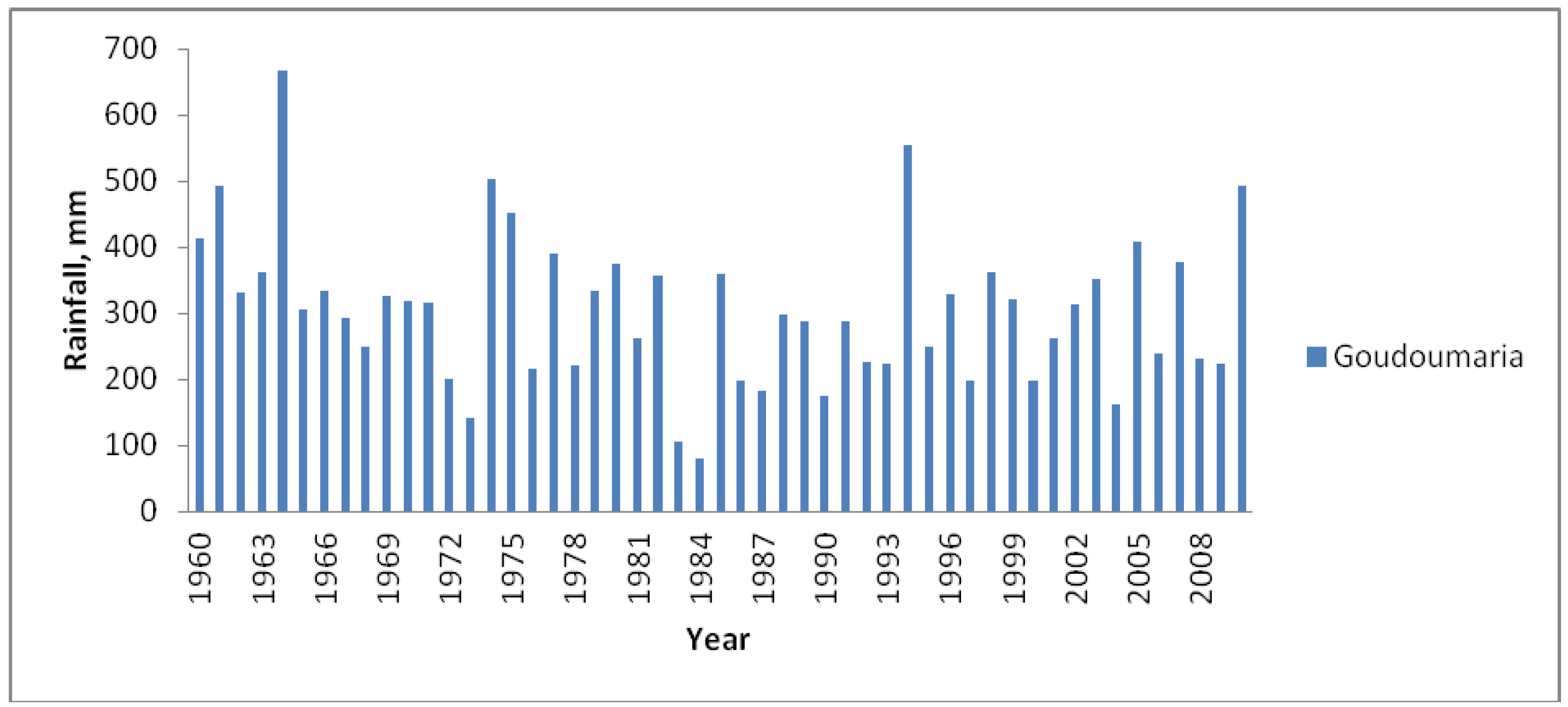
4.1. Rainfall Trends
The yearly precipitation data from 1960 to 2010 reveal the characteristic inter-yearly variability but also the existence of three main phases (
Figure 6). The first decade, which is prior to our land use study period, is part of an unusually wet period (1950–1969), with a mean yearly precipitation of 377 mm. From 1970 to 1989, the region experienced a prolonged drought phase, with an annual average as low as 280 mm. Finally, since 1990, an increased trend has been observed, with an annual mean of 294 mm, which does not, however, match the high levels of the 1950s–1960s, e.g., [
56], pp. 237–238.
It is also worth noting that the rainfall characteristics of the satellite acquisition years are the following: 1986 was a relatively dry year, following a year with more abundant rain; the same thing can be said about 1990 and 2000, whereas 2005 experienced relatively high rainfall following a drier year.
Figure 6.
Rainfall in Goudoumaria, 1960–2005 (Direction de la Météorologie Nationale (DMN)).
Figure 6.
Rainfall in Goudoumaria, 1960–2005 (Direction de la Météorologie Nationale (DMN)).
4.2. Population
Population figures from the statistics can only provide a rough indication of the changes during the last 25 years. They provide, however, the only information about population growth that is generally available. Goudoumaria had 45,029 inhabitants in 1988. In 2001 the figure reported by Niger national statistics [
57] was 72,784. The latest estimate for 2010 is 99,448 inhabitants [
52,
53]. The current population density is 14 persons per square km, and the population has doubled in the course of 22 years. Thus, the population-induced pressure on land has increased significantly.
The case villages illustrate the current diversity of size and ethnic composition. Kojimeri is a relatively large village with a recently established weekly market; the population (assessed from household visits in 2012) is 928; 90% of the inhabitants are Manga, whereas 3% and 5% are Peul and Touaregs, respectively. Bariram is a village located approximately five kilometers north of Kojimeri; the population is 417 (2012) and the ethnic composition is entirely Manga. Dinkari is smaller, with only 358 inhabitants; it is dominated by Peul (70%), followed by Manga (20%), and Touaregs (7%). Karagou has not been explored in detail; yet, previous information [
58] indicates that the Manga and the Peul dominate and are almost equal in importance.
4.3. Land Use Changes Observed from Satellite Images
The satellite image interpretation offers a detailed overview of the changes in cropland pattern in the period of 1986 to 2005 for the region around Goudoumaria as exemplified in
Figure 7.
Figure 7.
Example of screen-based, visual interpretation of Landsat image. Five landuse/landscape categories are distinguished: (1) fields in bas-fonds and cuvettes; (2) fields in the dune landscape; (3) cuvettes and bas-fonds land without cultivation; (4) bare land (mainly moving sand dunes but also bare, degraded soils); and (5) non-cultivated dune landscape/bush. The image shown is from 2005. The data in
Table 1 are the outcome of a similar interpretation of four corresponding satellite images from October 1986, 1990, 2000, and 2005.
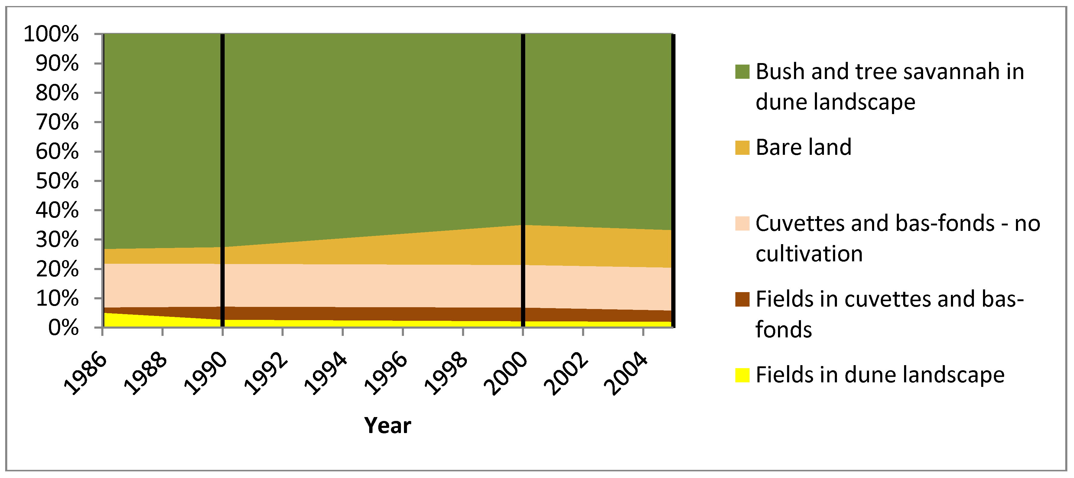
Table 1 and
Figure 8 show that the most remarkable overall observed change is for the category “bare land”, which has more than doubled in the period from 1990 to 2000. Hence, the sand encroachment process that was documented in the early 1990s [
47] seems to have continued until the present day. Field acreage on the dunes decreased sharply between 1986 and 1990, and has followed a downward trend since then. Field acreage in the cuvette and bas-fond landscape units doubled in size from 1986 to 1990, peaked in the year 2000 and declined in 2005. In total,
i.e., regardless of the landscape, the field acreage peaked in 1990. The dune fields dominated significantly in 1986, but this picture was completely reversed in 1990 and after, when they declined to approximately half of the extent of the fields in bas-fonds and cuvettes.
Table 1.
Land use/landscape categories; statistics derived from the satellite images (
cf. Figure 4).
Table 1.
Land use/landscape categories; statistics derived from the satellite images (cf. Figure 4).
| Year | Fields in
Cuvettes and Bas-Fonds | Fields in Dune Landscape | Cuvettes and Bas-Fonds—No Cultivation | Bare Land | Bush- and Tree-Savannah in Dune Landscape | Total Surface |
|---|
| 1986 | 9555 | 26,800 | 78,083 | 26,251 | 383,471 | 524,160 |
| 1990 | 23,290 | 14,426 | 76,398 | 29,881 | 380,065 | 524,160 |
| 2000 | 24,380 | 11,711 | 76,117 | 71,469 | 340,483 | 524,160 |
| 2005 | 20,199 | 10,729 | 76,620 | 67,091 | 350,521 | 524,160 |
Figure 8.
Diagram showing the transition of landuse/landscape categories in the study region (
cf. Table 1).
Figure 8.
Diagram showing the transition of landuse/landscape categories in the study region (
cf. Table 1).
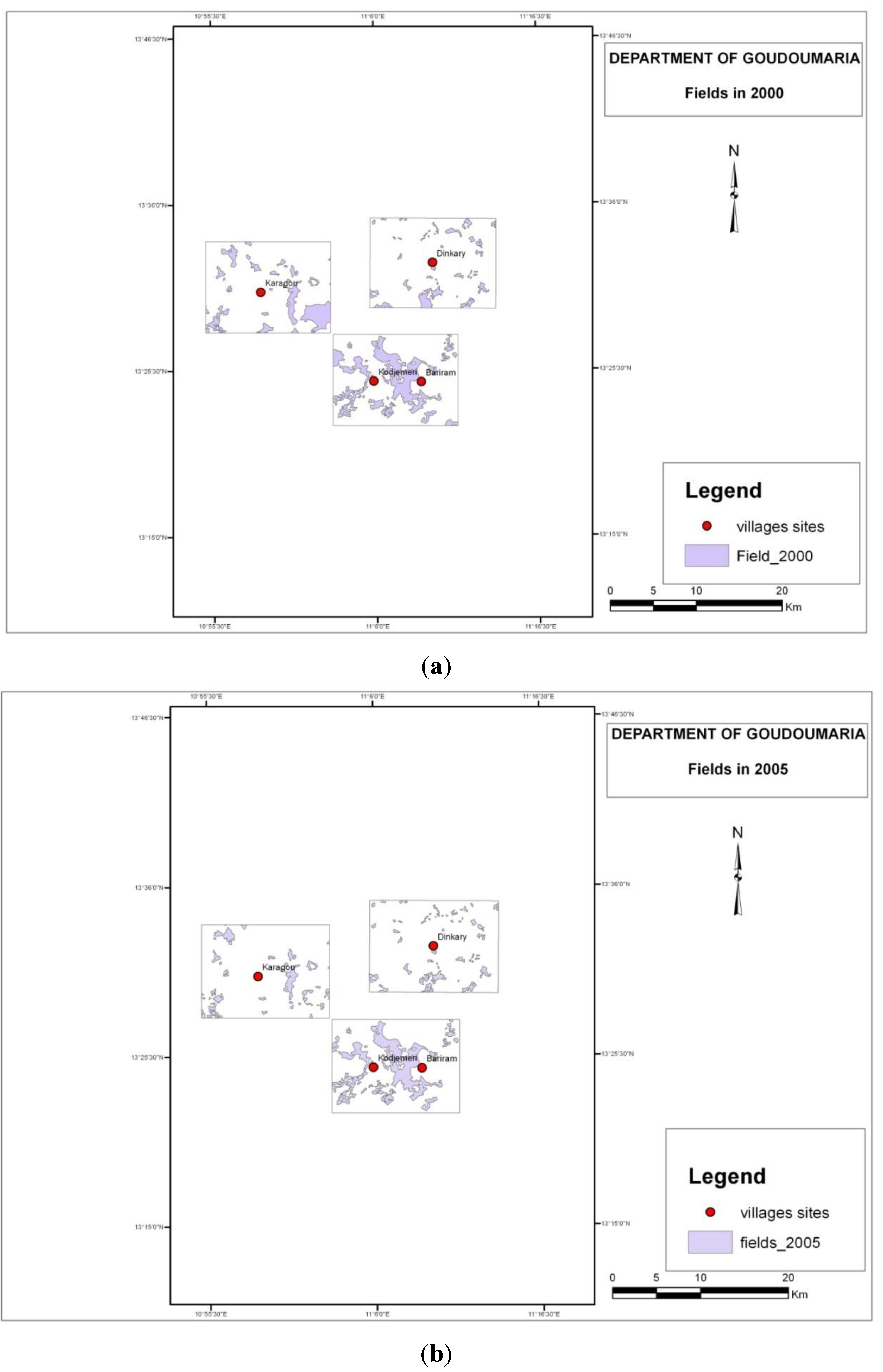
The diversity in the development of field patterns is exemplified for three subsections of the study region (
Figure 9a,b and
Table 2). The map sections serve to illustrate the land use structures around the four case villages only. It should be stressed that the territory does not correspond to the administrative village territory. Hence, no direct analogy can be made between these maps and the qualitative enquiry into land expansion around the villages. Nevertheless, it is interesting to observe that these examples almost exclusively point in the direction of a continuous decrease in cropland, just like the general pattern described above. Only in the case of Karagou did cropland expand in the first part of the period and then decrease rapidly in the following years (after 2005).
Figure 9.
(
a,
b) Field patterns in three “windows” of the study region in
Figure 7. These selected examples from 2000 and 2005, respectively, illustrate the characteristic feature of field shapes and location: there is a significant permanence, yet also important variations from one year to another.
Table 2.
Development of field acreage from 1986 to 2005 in the selected windows in
Figure 6.
Table 2.
Development of field acreage from 1986 to 2005 in the selected windows in Figure 6.
| Hectares-Fields | Sub-Zone/Village |
|---|
| Year | Dinkari | Bariram/Kojimeri | Karagou |
|---|
| 1986 | 1,710 | 3,623 | 1,867 |
| 1990 | 1,710 | 3,524 | 1,959 |
| 2000 | 980 | 3,344 | 2,053 |
| 2005 | 841 | 3,173 | 1,065 |
4.4. Contemporary Livelihood Strategies
Cultivation of vegetables and a number of other crops in the oases (cuvettes) contributes to sustaining the local livelihood; yet, millet and sorghum, cultivated in the fields in the bas-fonds or on the dunes, are considered the main staples by the local people. An important cash income is derived from commerce in natron excavated from the oases (and exported to, e.g., Nigeria), and agroforestry products from the oasis (most importantly dates), see, e.g., [
46,
58]). The income generating potential of these commodities fluctuates over time; yet, they still contribute significantly to the local livelihoods. It is difficult to provide a precise picture of the importance of the income in general as well as the more specific distribution on various sources (e.g., livestock, dates, natron, sesame,
etc.) because they vary hugely between the years. The larger survey referred to above provides an estimate of average yearly income per household for three of the case villages: Kojimeri, 136,581 Franc CFA (FCFA); Dinkari 229,550 FCFA; and Bariram 279,207 FCFA (650 FCFA = 1 Euro) [
53]. These figures do not provide insight concerning change in time; yet, they illustrate the significant local diversity and the low level of income.
Migration, seasonal as well as of longer duration, is an important source of income for many people. It plays a role in many families. Mainly young men (under 30) migrate for work, but also elderly people migrate, sometimes in order to “work” as beggars. The main destinations for work migration are Zinder, Niger, or Nigeria in the short term, and Libya has recently been a prominent destination for migration on a more permanent basis. The latter opportunity has, however, disappeared with the collapse of Libya in 2011, and people are returning. In-migration can also be important, but it varies across the region. The main origin of immigrants is Nigeria [
46]. It is, however, far from all households that benefit from remittances. The survey indicates that only approximately one out of four of the included households receive money from migrating relatives, e.g., Kojimeri 25%, Dinkari 25%, and Bariram 27% [
53].
4.5. Local Perceptions and Explanations of Change
In the qualitative interviews farmers unanimously reported that the cropland area has increased over the last 25 years (
Table 3).
Table 3.
Overview of farmers’ perception of trends in cropland and associated land use system characteristics—developments since mid-1980s (the big drought in 1984).
Table 3.
Overview of farmers’ perception of trends in cropland and associated land use system characteristics—developments since mid-1980s (the big drought in 1984).
| | Kojimeri | Bariram | Dinkari | Karagou |
|---|
| Cropland change—directions | Large expansion:
notably since 1999
notably on dunes | Large expansion (3 times)
Notably on dunes | Large expansion (3 times) | Expansion (mostly on dune) and contractions |
| Landscape unit preferences | Previous mainly bas-fonds, now also dunes | Previously mainly bas-fonds, now also dunes | n.a. | Shifting between dune and bas-fond according to rainfall |
| Role of fallow | Some reduction—but highly individual strategies | Before important—now replaced by manuring | Same procedure as always—3–5 years’ rest | Highly individual strategies |
| Interpretation of rainfall trends | Perception of general decrease | Perception of general decrease | Perception of general decrease | Perception of general decrease |
| Driving forces for field expansion (as mentioned by farmers) | Drought
Population growth increase
In-migration | Population growth
Loss in soil fertility
Introduction of plows | Population growth
Less rain
Introduction of plows | Population growth
Less rain |
| Farmers assessment of land abundance | No perceived land shortage | Still idle land | No more land for expansion | No more land for expansion in bas-fonds |
| Other adjustment to change | Opportunistic crop change (sesame) in good year (2010) | Income generation from horticulture and migration | Migration (seasonal and permanent)
Selling livestock (de-stocking) | Migration (exodus)
Selling livestock
Horticulture (cuvettes) |
| Relations with pastoralists | Conflicts related to cropland expansion on dunes | No significant conflicts | No conflicts | n.a. |
Rainfall is an issue of major attention. In all four surveyed villages, rainfall was perceived to be declining and less adequate in recent decades, but the interviewees were unable to provide details of this observation in terms of yearly characteristics. One recent year, 2010, was consistently noted for its abundant rainfall. An indication of the importance of the diminishing rain is that Dinkari and Bariram currently need to cultivate three times the amount of land as “before” to feed a person.
Population pressure is perceived as significantly changed. The situation varies, however, considerably within the region and the case villages. Kojimeri is a relatively large village, where the population has grown remarkably during the last twenty years; the estimated growth in the number of households from 1984 to 2011 was from 40 to 150, of which approximately half are newcomers to the village from neighboring areas. Among the three case villages, in-migration is only mentioned as prominent in Kojimeri, where land is still considered abundant (as compared, e.g., to the region towards the west). Many of the newcomers have, however, only limited land as compared to the original population. The two main assets that seem to attract people to Kojimeri are the health center and the market. The latter was established only eight years ago—and gives an attractive possibility of buying and selling products—as well as a “fee” profit for the village.
Bariram and Dinkari also report large changes in population size, but mainly perceive these to be a result of the local excess of births. In fact, informants in both villages independently estimate that the cropland has tripled, almost corresponding to the population growth.
New technology is another important factor determining the land use changes. Dinkari and Bariram have recently taken plows into use. This has enabled them to expand the cropland further. The plows are used by the owners and borrowed by close family members while other people in the village can borrow them against payment. The capacity of the equipment is still insufficient to cover the needs of the entire village.
Environmental degradation, in terms of, for example, dune encroachment or soil exhaustion, has had some effects on the field expansions and allocations that have taken place; yet with significant local differentiation in importance. Farmers from Bariram explicitly refer to soil degradation as a reason for enlarging the field acreage, and Dinkari farmers have abandoned fields to the north of the village due to severe sand encroachment.
Access to land and conflicts with other villages play a role in land use flexibility. This is not something new, and not mentioned as a very important driver of change. However, multiple conflicts with the pastoralists are noted as a result of the field expansions. The attention to the issue varies between villages. It is, for example, not of great concern in Kojimeri. In principle, land has to be granted by the head of household, but this is not a real constraint because there is no shortage of land. Interestingly, farmers in Dinkari do not have conflicts with pastoralists despite the fact that they explicitly talk of a shortage of agricultural land. In other words, there is no simple relation between land availability, expansion patterns, and land users; it seems to be based on site-specific, possibly ethnic and cultural characteristics of the respective villages.
It has been described how expansions of cropland follow multiple, strategic pathways. They are complex with respect to the prioritization of the main landscape units as well as the intensity of the cropping. There is a general tendency across the villages to acknowledge that the dune soils provide the best yields in dry years (as known from other settings, e.g., [
59]). The village-specific field expansion pattern was, however, also reported to be significantly influenced by the local importance of fallowing as well as by the abundance of perceived “idle land”. Kojimeri reported considerable expansions in the dune landscape; it was also noted that the expansion in this village territory took place at the expense of bushland as well as by reducing fallow length for formerly cultivated plots. In Bariram, expansion is reported in all landscape types. In this village, there is still idle land for cultivation, and, in that respect, no immediate need to change the tradition of leaving the fields in fallow for five years (to regain fertility). Fallow has nonetheless lost importance because it has been replaced by animal manure in the dune landscape as well as in the bas-fonds. In Dinkari, field expansion is not considered to compete with range land or incur the need to reduce fallow time. In this village there was, however, a very clear notion of imminent land saturation; almost all land suitable for cultivation was considered to be currently in use.
4.6. Composite Lenses: Contemplating Climate-Population-Cropland Trajectories
The group discussions addressed local peoples’ perception of the possible co-evolution of land use and cultivation strategies and the main causes of change, considering processes of climate change and economic globalization in concert.
The region is, indeed, very remote and hence remarkably untouched by huge alterations triggered by the contemporary globalization of the economy. As marked above, trade with salt, natron, dates, and livestock has taken place for many years; yet, the infrastructure in the region consists many of paths and sandy tracks in the dune landscape, which do not allow for easy use by trucks or cars. Cropland basically serves to provide food for local consumption, and cropland expansion is hence primarily driven by local population pressure and changes in soil productivity. Enhanced connectivity to the market, information about technology, as well as involvement in national and international migration has had some influence on the land use trends. The new local market in Kojimeri has facilitated the marketing of livestock, which was noted to be a major land sparing strategy in Dinkari (“we cover the food need by selling off livestock, because we do not have more land to expand the fields”). Enhanced connectivity has led to an increase in the volume of migrants, which has led to an influx of people to some areas (e.g., in Kojimeri) and a corresponding increase in cropland, while elsewhere there has been a temporary or more permanent exodus of people (e.g., due to migrations to Libya from Karagou and Kojimeri; to Nigeria and Zinder from Kojimeri and Dinkari). The introduction of plows has led to a major differentiation between villages in their interpretation of the sufficiency of available land resources. Yet, not all villages in the region have so far adopted this technology with its significant potential implications for future pressure on land.
By exploring land use change processes as enabled and constrained by the socio-economic as well as the ecological conditions (
i.e., a land change science perspective, [
23]) it clearly emerged that the rainfall pattern was perceived as an important determinant. Farmers described their use of the different landscape units with a view to their comparative advantages in dry and less dry years. They explained that previously, only bas-fonds were cultivated, and that currently, the acreage in this landscape unit is being further increased. In the event of drought, fields are expanded to the dune landscape as well. With 2010 as an exception, recent decades have been considered dry; hence, the land use in the dune landscape has been important. Only minor changes in crop choice in response to climate (and soil fertility) were reported. One example, however, is that the good rains in 2010 inspired farmers to put more effort into sesame cultivation (with bad outcomes, because the rain failed in 2011). In other words, a negative, causative vulnerability was observed: Good rains in 2010 triggered increased interest in sesame and cowpeas, yet the increased emphasis resulted in larger losses of these drought sensitive crops in 2011, when the rain again was low.
Although some systematic causal relations between climate, population pressure and socioeconomic events can be discerned from the group interviews, the complexity of the change process, as well as their local character, is glaring. Human-environmental timelines demonstrate how site-specific details have often ousted more generic traits as explanations for changes in land use and natural resource management strategies [
46]. While drought and population pressure were mentioned as important factors in land use changes, a number of other shifting opportunities and constraints came together with these driving forces to determine the land use strategies (such as trade, migration, new cultivars, market access). The fallow “strategy” is, for example, guided by opportunities rather than systematic strategies. If a field in the bas-fonds is sufficiently large, some of it can be allocated for fallow. If it is small, the farmer will try to expand in the dune landscape in order to liberate some of the bas-fond fields for fallow, but if this is not possible, fallow will be abandoned altogether. Hence, landscape priorities, soil degradation, and precipitation trends are connected in complex manners that make land use change cause-effect analysis equally complex.
5. Discussion
The research results presented above were primarily the outcome of our initial interest in exploring the seemingly straightforward question: what are the trends in cropland change in the course of thirty years?—And, what is the relation to population increase or climate change? Researchers and policy makers have for decades considered this issue of land change in the Sahel important for the assessment of sustainability and resilience of human-environment interaction (e.g., [
6]); yet, the lack of accurate information seems to remain a serious challenge [
16].
The pool of knowledge about the land systems in SE-Niger is indeed very limited; it is confined to a few research articles (e.g., [
47,
50,
60]), and some consultancy reports (e.g., [
61,
62]). In that respect, on the one hand, we trust that information about directions of land cover changes is valuable in its own right. On the other hand, understanding the causal relationship behind the land changes is complex. As it is stressed by Mortimore
et al. ([
8], p. 113), drawing on experience from a set of African dryland cases, it is crucial to analyse land use and land cover data within a formal framework linking them with both transitions (temporal dynamics) and local level processes, if understanding and predicting land use changes should be rescued from simplistic causal explanations like population pressure or climate changes. Based on work from another part of Niger, Turner [
63,
64] also provides important reflections in support for “thinking of regionally scaled land use change as resulting from regionally scaled factors as mediated by local social relations” ([
63], p. 212). His study showed that relations in the domestic sphere played a critical mediating role between regional pressures and local land use. This supports that mixed approaches, combining quantitative and qualitative methods and addressing varying spatial and social scales must be applied [
65]. It is beyond the ambition of the current paper to implement a complex analysis. A few indications have been provided with reference to the material about livelihood conditions, e.g. the importance of other income generating activities, issues that are dealt with in more detail in [
46,
53]. The background material supports, however, the findings that were stressed by Mortimore
et al. [
8],
i.e., (a) that land cover changes are insensitive to short term changes in economic circumstances, mainly because of the subsistence priority; and (b) that land use changes are embedded in broader changes in livelihood strategies, whose understanding is necessary before constructing land change scenarios for larger areas.
Acknowledging the need for exploring socio-ecological complexities of land systems, we have in this article chosen to direct our main attention to the harvesting of information about land cover, with the aim of discussing the reliability of data. In land change research, on the one hand, it has been appreciated that land use statistics are scarce and unreliable for less developed regions such as the Sahel [
16]. On the other hand, it has been generally recognized that valuable insight has been gained from explorations that have chosen to rely on the visual interpretation of satellite imagery (e.g., [
66]) or on local peoples’ appraisals (e.g., [
67]). Both approaches have been considered to deliver a reasonable proxy, for example, cropland in the absence of better options and have been used to provide the information platform for policy documents. Hence, these two complementary approaches were expected to provide a reasonably consistent characterization of the directions of change in the study region. In the course of the analysis presented above, it became, however, clear that the choice of method unexpectedly made a world of difference for the assessment of cropland dynamics. In fact, different methods point in different directions when the focus is the nexus between field expansions, rainfall conditions, demographic pressure, available agricultural technology, and land degradation.
The land cover/landscape unit transition profile sketched out by the quantitative, satellite-based assessment reveals a relatively significant increase in degraded (bare) land in the time window from 1990 to 2000. The total amount of cultivated land changed only marginally in the period from 1986 to 2000, and then decreased (by a little more than 10%) until 2005. On a more detailed level, it is worth noting that the extent of the cultivation on the dune is declining. Hence, the mapped land cover/landscape units do not provide support for the thesis that dune landscapes are specifically preferred for fields in dry years inasmuch as the years 1990 and 2000 are low rainfall years.
This is in sharp contrast to the land cover/landscape transition profile derived from the qualitative descriptions provided by the farmer interviews. All group interviews unanimously describe a change that encompasses expansions of cropland, specifically since 1999. The trends are explained as responses to less rain, more people, and in some cases, also new technology (plows) or soil degradation. They also stress that fields on the dune have become more and more important as compared to fields in the bas-fonds. This discrepancy between the oral descriptions of change and the description derived from satellite image interpretation can hardly be explained by the fact that the interviews took place in 2011,
i.e., six years after the last satellite image acquisition. The impressions of the conditions in recent years can, of course, to some extent overshadow the farmers’ long-term memory and influence what they remember of the past. It is also possible that rapid land changes have occurred due to sudden events, for example, field expansions driven by the introduction of plows may have taken place very recently and may not be captured in the satellite images. The longer-term trends (
cf. Table 3) were, however, expected to be portrayed in the same way, regardless of the choice of method.
The inability of case studies to validate generalisations has been stressed in other contexts (e.g., [
68]). They can be mistaken as a method, because they do not produce fact that can be prove or disprove claims about what happen on a more general scale. Following this vein, the lack of commensurability between the qualitative and quantitative land change assessments deserve to be further scrutinized in order to explore possible root causes for the difference. It could be that the respondents in the group interviews represent a certain, biased, segment of the land users, which have other priorities and constraints than the average person. Migration, for example, may in fact have the role of alleviating the overall pressure on land and could explain that remote sensing provide lower figures for cropland expansion than those perceived by the active farmers in the group interview if they have no connection to migration.
The cumulative impact of previous assessments of the land cover dynamics has also been suggested to be a challenge to accurate characterizations because it may create myths, which are, in turn, adopted as general truth [
6]. Decades of policy and project documents from the Sahelian region have stressed the narratives of degradation and field encroachment and the notions have been well known among the farmers. Hence, they are very likely to be well known by local people and, as a result, be given prominence in qualitative interviews.
6. Conclusions and Perspectives
The study demonstrates that the notion of accelerated pressure on land due to field expansion corresponds well to the local farmers’ perceptions in SE-Niger. There is, indeed, consistent qualitative evidence that fields are expanding, notably on the sandy soils in the dune landscape. This trend corresponds well to what would be expected to take place given the increased population pressure and drier conditions.
Farmers describe how the overall trends are accumulations of a number of diverging directions of change at the local level. Some important factors actually lead to less pressure on land (e.g., changed manuring practices, migration, livestock sales) and slow down the effect of demographic pressure and rainfall variability, whereas others accelerate the demand for cropland beyond the linear prediction related to population growth (e.g., the introduction of plows). This renders simple forecasting of land use from the qualitative enquiries very difficult. In their vision for the future, farmers assumed a rather negative position. They acknowledge, in general, that it is not possible to produce sufficient millet and sorghum for food today (as it was before); hence, income generated by migration, livestock sales, and oasis gardening plays an important role for food provision. They know well that the population will increase—and so will the demand for food. This is linked to an emergent saturation of cropland by the farmers. In Dinkari they explicitly note that they have already reached the “glass ceiling” of field expansion; there is no more land for further expansion within the village territory. Currently, they manage by gradually selling out of the livestock herd, but in response to the question about what to do in 10 years’ time, they responded “Allah will see to that”.
The notion of field expansion and land saturation is not well supported when compared with the satellite-based verification of cropland changes. Although there are always reservations about the accuracy of field mapping from satellite images in arid environments, where land use classes can be very difficult to distinguish, it seems reasonable to expect that this source of information provides a fair indication of the order of magnitude and direction of the change.
These inconsistencies warn against making firm statements about the contemporary land change trends in SE-Niger from widely acknowledged analytical approaches and remind us that caution must be exercised before making generalizations about land use changes on the basis of the best information available.
To sum up, the outcome of the combined qualitative and quantitative assessment of land changes does not immediately point in the same direction. This could be the result of a shifting role of the land-based production in the livelihood portfolio. In the study region, migration and oasis cultivation for cash have become more prominent elements. Hence, those who pursue traditional agriculture may expand their land and observe an emerging saturation of land, while, for the region as a whole, field acreage may de facto not increase at the same speed as, e.g., the population or decline in soil fertility.
It seems, however, plausible to conclude that local livelihoods are under pressure due to population growth and continued climate variability. Local people perceive that the land resources are becoming scarce. As with elsewhere in the Sahel, the assumption that rural people should be self-sufficient with regard to their food production may no longer hold true [
68]. Livelihoods in the Sahel have evolved rapidly over the past decades and may be on the threshold of incipient transition [
8]. Households are increasingly being impoverished and rely on markets or remittances. For poor agro-pastoralist households, resources in the form of their own cattle and crops no longer represent their main sources of food and income


