Regional Deforestation Trends within Local Realities: Land-Cover Change in Southeastern Peru 1996–2011

Abstract
:1. Introduction
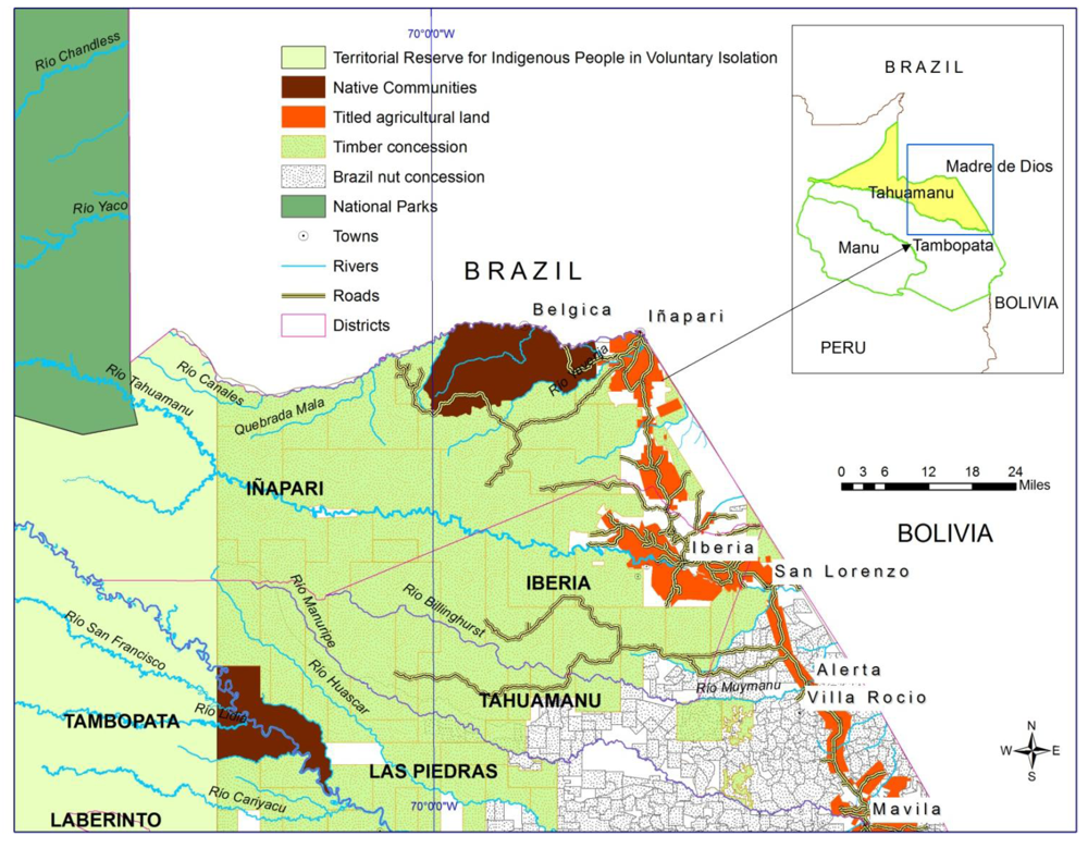
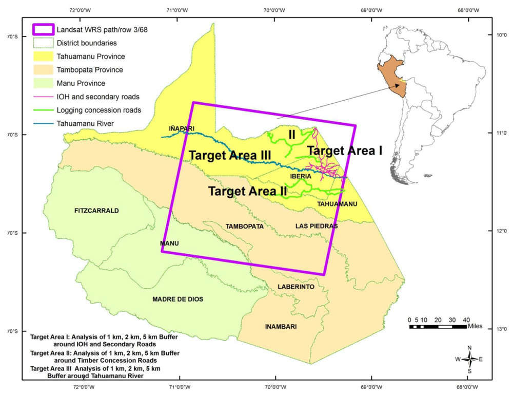
2. Study Region
- Target Area I. Agricultural lands along the IOH and its secondary roads
- Target Area II. Timber Concession areas and Protected Areas
- Target Area III. Tahuamanu River Watershed Area
2.1. Policy Shifts and LULCC

2.2. Tenure Categories, Land Uses and Their LCC Impacts
2.2.1. Agricultural Properties

| Agricultural Land Use | Area in ha | Percentage |
|---|---|---|
| Brachiaria Grass | 3,453 | 53 |
| Maize | 1,451 | 22 |
| Rice | 902 | 14 |
| Plantain | 150 | 2 |
| Beans | 135 | 2 |
| Manioc | 130 | 2 |
| Yaragua Grass | 116 | 2 |
| Papaya | 35 | 0.5 |
2.2.2. Timber and Castaña Concessions and Protected Areas
| Year | Roundwood Production in m3 | Sawn Timber Production in m3 |
|---|---|---|
| 2000 | 266,611 | 138,105 |
| 2001 | 132,191 | 68,475 |
| 2002 | 163,629 | 85,223 |
| 2003 | 175,376 | 91,341 |
| 2004 | 158,530 | 72,316 |
| 2005 | 191,410 | 86,728 |
| 2006 | 251,636 | 84,405 |
| 2007 | 196,652 | 99,665 |
| 2008 | 253,498 | 128,377 |
| 2009 | 290,449 | 139,315 |
| 2010 | 330,659 | 134,614 |
2.3. Transportation Routes and Their LULCC Impacts
| Iñapari District | Iberia District | Tahuamanu District | Tahuamanu Province | Madre de Dios Region | |
|---|---|---|---|---|---|
| Population 1972 | 504 | 4,015 | 817 | 5,336 | 25,174 |
| Population 1981 | 812 | 3,013 | 1,103 | 4,928 | 35,788 |
| Growth Rate 1972–1981 | 5.4 | −2.4 | 3.4 | −0.2 | 3.9 |
| Population 1993 | 870 | 3772 | 1,744 | 6,443 | 71,636 |
| Growth Rate 1981–1993 | 0.6 | 1.9 | 3.9 | 2.3 | 6.1 |
| Population 2007 | 1,288 | 6,715 | 2,739 | 10,742 | 109,600 |
| Growth Rate 1993–2007 | 2.8 | 4.2 | 3.3 | 3.7 | 3.1 |
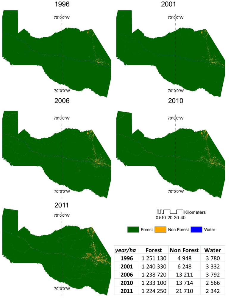
2.4. Remote Sensing and Survey Data
| Sensor | Image Date |
|---|---|
| Landsat 5 TM | 23 July 1996 |
| ETM+ Landsat 7 | 29 July 2001 |
| Landsat 5 TM | 16 May 2006 |
| Landsat 5 TM | 30 July 2010 |
| Landsat 5 TM | 3 September 2011 |
| 2010 Reference Data | ||||||
|---|---|---|---|---|---|---|
| 2010 Classified Data | FOREST | NON-FOREST | WATER | Classified Total | User’s Accuracy | |
| FOREST | 60 | 4 | 2 | 66 | 0.90 | |
| NON-FOREST | 2 | 54 | 1 | 57 | 0.95 | |
| WATER | 5 | 1 | 38 | 43 | 0.88 | |
| Reference Total | 67 | 55 | 41 | 166 | ||
| Producer’s Accuracy | 0.89 | 0.98 | 0.93 | |||
| Overall Accuracy = 0.915 | ||||||
3. Results and Discussion
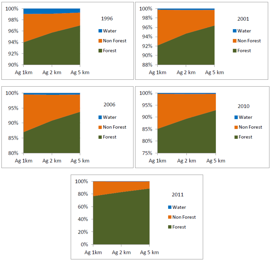
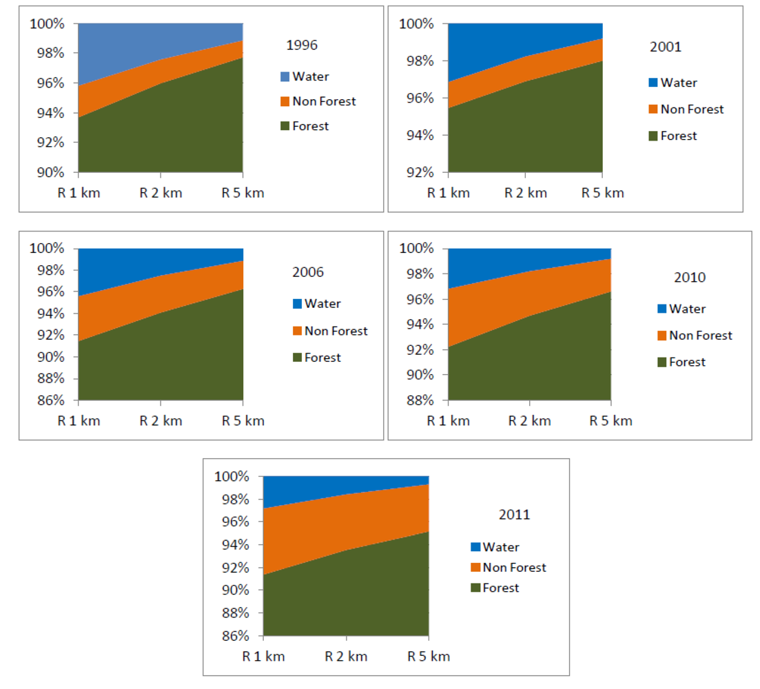
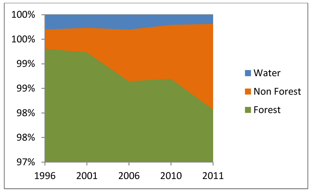
3.1. Results on Temporal and Spatial Variation in LULCC Based on before, during, and after Paving
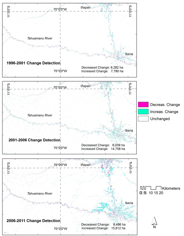

3.2. Results on Temporal Variation and Spatial Variation in LULCC Based on Distance from Highway, Timber Concession Roads, and Tahuamanu River Watershed


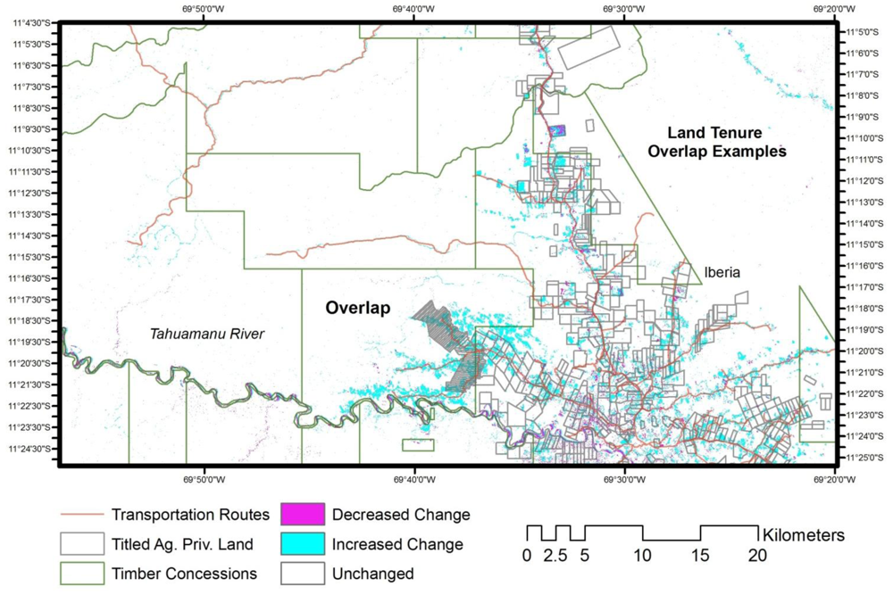
3.3. Discussion on Variation in LULCC among Tenure Types and Overlaps

4. Conclusions
Acknowledgments
References
- Land-Use and Land-Cover Change: Local Processes to Global Impacts; Lambin, E.F.; Geist, H.J. (Eds.) Springer-Verlag: Heidelberg, Germany, 2006.
- Gutman, G.; Janetos, A.; Justice, C.; Moran, E.; Mustard, J.; Rindfuss, R.; Skole, D.; Turner, B.L., II. Land Change Science: Observing, Monitoring, and Understanding Trajectories of Change on the Earth’s Surface; Kluwer Academic Publishers: Dordrecht, The Netherlands, 2004. [Google Scholar]
- Geist, H.J.; Lambin, E.F. Proximate causes and underlying driving forces of tropical deforestation. BioScience 2002, 52, 143–150. [Google Scholar] [CrossRef]
- Fearhead, J.; Leach, M. Reframing Deforestation: Global Analyses and Local Realities: Studies in West Africa; Routledge: New York, NY, USA/London, UK, 1998. [Google Scholar]
- Malhi, Y.; Wright, J. Spatial patterns and recent trends in the climate of tropical rainforest regions. Phil. Trans. R. Soc. London 2004, 359, 311–329. [Google Scholar] [CrossRef]
- Angelsen, A.; Kaimowitz, D. Rethinking the causes of deforestation: Lessons from economic models. World Bank Res. Observ. 1999, 14, 73–98. [Google Scholar] [CrossRef]
- Hecht, S. Soybeans, development, and conservation on the Amazon Frontier. Dev. Change 2005, 36, 375–404. [Google Scholar] [CrossRef]
- Brondízio, E. S.; McCracken, S.D.; Moran, E.F.; Siqueira, A.D.; Nelson, D.R.; Rodriguez-Pedraza, C. The Colonist Footprint: Toward A Conceptual Framework of Land Use and Deforestation Trajectories among Small Farmers in the Amazonian Frontier. In Deforestation and Land Use in the Amazon; Wood, C.H., Porro, R., Eds.; University of Florida Press: Gainesville, GA, USA, 2002; pp. 133–161. [Google Scholar]
- Aldrich, S. P.; Walker, R.T.; Arima, E.Y.; Caldas, M.M. Land-cover and land-use change in the Brazilian Amazon: smallholders, ranchers, and frontier stratification. Econ. Geogr. 2006, 52, 265–288. [Google Scholar]
- Schmink, M.; Wood, C.H. Contested Frontiers in Amazonia; Columbia University Press: New York, NY, USA, 2002. [Google Scholar]
- Walker, R.; Browder, J.; Arima, E.; Simmons, C.; Pereira, R.; Caldas, M.; Shirota, R.; Zen, S. Ranching and the new global range: Amazônia in the 21st Century. Geoforum 2009, 40, 732–745. [Google Scholar] [CrossRef]
- Carvalho, G.; Barros, A.C.; Moutinho, P.; Nepstad, D. Sensitive development could protect Amazonia instead of destroying it. Nature 2001, 409, 131. [Google Scholar]
- Laurance, W.F.; Cochrane, M.A.; Bergen, S.; Fearnside, P.M.; Delmônica, P.; Barber, C.; D’Angelo, S.; Fernandes, T. The future of the Brazilian Amazon. Science 2001, 291, 438–439. [Google Scholar] [CrossRef]
- Andersen, L.E.; Reis, E.J. Deforestation, development and government policy in the Brazilian Amazon: an econometric analysis. In Working Paper 513; Instituto de Pesquisa Econômica Aplicada (IPEA): Rio de Janeiro, Brazil, 1997. [Google Scholar]
- Cattaneo, A. Deforestation in the Brazilian Amazon: Comparing the impacts of macroeconomic shocks, land tenure, and technological chang. Land Econ. 2001, 77, 219–240. [Google Scholar] [CrossRef]
- Eden, M.J. Forest and Environmental Degradation. In Tropical Rain Forest: A Wider Perspective—Conservation Biology Series; Goldsmith, F.B., Ed.; Chapman & Hall: London, UK, 1998. [Google Scholar]
- Kaimowitz, D.; Angelsen, A. Economic Models of Tropical Deforestation: A Review; The Council to Improve Foodborne Outbreak Response (CIFOR): Bogor, Indonesia, 1998.
- Nepstad, D.; Carvalho, A.C.; Barros, A.; Alencar, A.; Capobianco, J.P.; Bishop, J.; Moutinho, P.; Lefebre, P.; Silva, U.L.; Prins, E. Road paving, fire regime, feedbacks, and the future of Amazon forests. Forest Ecol. Manag. 2001, 154, 395–407. [Google Scholar]
- Alves, D. An Analysis of the Geographical Patterns of Deforestation in the Brazilian Amazon in the Period 1991–1996. In Deforestation and Land Use in the Amazon; Wood, C.H., Porro, R., Eds.; University of Florida Press: Gainesville, GA, USA, 2002; pp. 95–106. [Google Scholar]
- Gerencia Sub Regional de Madre de Dios (GESUREMAD), lan Estratégico de Desarrollo del Departamento de Madre de Dios 1998-2008; GESUREMAD: Puerto Maldonado, Perú, 1998.
- Instituto Nacional de Desarrollo-Organización de los Estados Americanos (INADE-OEA), Plan de Desarrollo de las Comunidades Fronterizas Peruano-Brasileñas, Iñapari-Assis Brasi; Consejo Interamericano para el Desarrollo Integral de la Organización de los Estados Americanos (CIDI/OEA): Bogotá, Colombia, 1998.
- Imbernon, J. A comparison of the driving forces behind deforestation in the Peruvian and the Brazilian Amazon. Ambio 1999, 28, 509–513. [Google Scholar]
- Food and Agricultural Organization-United Nation (FAO), Actualización de la Evaluación de los Recursos Forestales Mundiales a 2005. Informe Final; Instituto Nacional de Recursos Naturales (INRENA): Lima, Perú, 2005.
- World Bank, Análisis Preliminar Sobre Gobernabilidad y Cumplimiento de la Legislación del Sector Forestal en el Perú; World Bank: Washington, DC, USA, 2006.
- Alvarez, N.; Naughton-Treves, L. Linking national agrarian policy to deforestation in the Peruvian Amazon: A case study of Tambopata, 1986–1997. Ambio 2003, 23, 269–274. [Google Scholar]
- Mäki, S.; Kalliola, R.; Vuorinen, K. Road consequences in the Peruvian Amazon: Process, causes and consequences. Environ. Conserv. 2001, 28, 199–214. [Google Scholar]
- Killeen, T.J. A Perfect Storm in the Amazon Wilderness: Development and Conservation in the Context of the Initiative for the Integration of the Regional Infrastructure of South America (IIRSA). Advances in Applied Biodiversity Science No 7; Conservation International: Arlington, VA, USA, 2007. [Google Scholar]
- Dourojeanni, M. J.; Barandiaran, A.; Dourojeanni, D. Amazonia Peruana en 2021. Explotación de Recursos Naturales e Infraestructura. Que está Pasando? Que es lo que Significa para el Futuro? 1st ed; GyG Impresores SAC: Lima, Perú, 2009. [Google Scholar]
- Futemma, C.; Brondizio, E. Land reform and land-use changes in the lower Amazon: Implications for agricultural intensification. Hum. Ecol. 2003, 31, 369–402. [Google Scholar] [CrossRef]
- Deforestation and Land Use in the Amazon; Wood, C.H.; Porro, R. (Eds.) University of Florida Press: Gainesville, FL, USA, 2002.
- Walker, R.; Wood, C.H.; Skole, D.; Chomentowski, W. The Impact of Land Titling on Tropical Forest Resources. In Linking People, Place and Policy: A GIScience Approach; Walsh, S., Crews-Meyer, K., Eds.; Kluwer Academic Publishers: London, UK, 2002; pp. 131–153. [Google Scholar]
- Nelson, A.; Chomitz, K.M. Protected Area Effectiveness in Reducing Tropical Deforestation: A Global Analysis of the Impact of Protection Status; World Bank Independent Evaluation Group, World Bank: Washington, DC, USA, 2009.
- Fox, J. Understanding a Dynamic Landscape: Land Use, Land Cover and Resource Tenure in Northeastern Cambodia. In Linking People, Place and Policy: A GIScience Approach; Walsh, S., Crews-Meyer, K., Eds.; Kluwer Academic Publishers: London, UK, 2002; pp. 113–130. [Google Scholar]
- Plan de Ordenamiento Territorial del Departamento de Madre de Dios al 2030; Documento de Trabajo para Consultas Publicas, Gobierno Regional de Madre de Dios (GOREMAD): Puerto Maldonado, Perú,, 2011.
- Naughton-Treves, L. Deforestation and carbon emissions at tropical frontiers: A case study from the Peruvian Amazon. World Dev. 2004, 32, 173–190. [Google Scholar] [CrossRef]
- Consejo Nacional del Ambiente-Instituto Nacional de Recursos Naturales (CONAM-INRENA), Mapa de Deforestación de la Amazonia Peruana-2000; Memoria Descriptiva Volumen I-IM-03-02; PROCLIM/CONAM/INRENA: Lima, Perú, 2005.
- Elgegren, J.; Lee, D. Deforestation in Peru. Working Paper; World Bank: Washington, DC, USA, 2006.
- Alcalde, M. Diagnostico de la Deforestación en el Perú; USAIDINRENA-BIOFOR Activity: Lima, Perú, 2002.
- National Institute of Statistics and Informatics (INEI), Análisis Socio Demográfico del Departamento de Madre de Dios; INEI: Lima, Perú, 2007. Available online: www.INEI.gob.pe (accessed on 26 May 2010).
- Instituto Nacional de Estadística e Informática (INEI), Instituto Nacional de Estadística e Informática; INEI: Lima, Perú, 2004.
- Chavez, A.; Perz, S. Adoption of policy incentives and land use: Lessons from frontier agriculture in Southeastern Peru. Hum. Ecol. 2012, 40, 525–539. [Google Scholar] [CrossRef]
- Tahuamanu Municipalidad Provincial. Plan Estratégico de Desarrollo; Documento de Trabajo: Tahuamanu, Peru, 2001.
- nstituto de Investigaciones de la Amazonía Peruana (IIAP)/Consejo Transitorio de Administración Regional de Madre de Dios (CTAR-MDD), Madre de Dios, Camino al Desarrollo Sostenible: Propuesta de Zonificación Ecológica Económica Como Base Para el Ordenamiento Territorial; Impresiones C.E.T.A.: Iquitos, Perú, 2001.
- Chavez, A. Public Policy and Spatial Variation in Land Use and Land Cover in the Peruvian Amazon. Ph.D. Dissertation, University of Florida, Gainesville, FL, USA, 2009. [Google Scholar]
- Consejo Transitorio de Administración Regional (CTAR), Plan Estratégico Concertado de Desarrollo Madre de Dios 2002-2004; CTAR: Puerto Maldonado, Perú, 2002.
- Tarrier, D. Actualización del Plan Maestro del PNAP—Diagnostico Socio-EconómicoCultural Sector Madre de Dios; Ministerio del Ambiente del Perú: Lima, Perú, 2010.
- Ministerio de Agricultura/Instituto Nacional de Recursos Naturales (INRENA), Zonificación Ecológica-Económica Yaco-Iñapari e Iberia-Iñapari, Madre de Dios; Reporte Técnico; Lima, Perú, 1998.
- Gobierno Regional de Madre de Dios (GOREMAD), Macrozonificación Ecológica Económica de Madre de Dios; GOREMAD: Puerto Maldonado, Perú, 2009.
- Municipalidad Distrital de Iberia, Plan de Desarrollo Concertado del Distrito de Iberia al 2021, Unpublished Report. 2010.
- Del Aguila, S.D. Caracterización de la Cuenca del Rio Tahuamanu, Unpublished Report; Gobierno Regional Madre de Dios—Proyecto Especial Madre de Dios, Consorcio MP: Iberia, Perú, 2010.
- Del Aguila, S.D. Plan de Gestión Participativa de la Subcuenca del Rio Yaverija, Unpublished Report; Gobierno Regional Madre de Dios—Proyecto Especial Madre de Dios, Consorcio MP: Iberia, Perú, 2010.
- Gobierno Regional de Madre de Dios-Proyecto Especial Madre de Dios (GOREMAD-PEMD), Estrategia para el Desarrollo y la Integración Fronteriza de Madre de Dios 2011–2021; GOREMAD/PEMD: Puerto Maldonado, Iberia, Perú, 2010.
- Nalvarte Armas, W.; Sabogal, C.; Thiel, H. Evaluación del Impacto del Cobro por Derechos de Aprovechamiento de Madera en pie y Otras Tasas Sobre el Manejo Forestal en Perú; Programa de Cooperación FAO/Banco Mundial; Food and Agricultural Organization of the United Nations (FAO-UN) and World Bank: Rome, Italy, 2012; Volume VI.
- Del Aguila, S.D. Comunidad Nativa de Bélgica: Propuesta de Plan de Ordenamiento Territorial Comunal, Unpublished Report; Gobierno Regional Madre de Dios, Proyecto Especial Madre de Dios, Consorcio MP,: Iberia, Perú,, 2010.
- Broto, L.; Murray, J.; Pettenella, D.; Secco, L.; Masiero, M. Biodiversity in the Peruvian Amazon. ETFRN News 2010, 51, 112–119. [Google Scholar]
- Che, P.H.; García, T. Estudio REDD Perú: La Situación de REDD en el Perú; Derecho Ambiente y Recursos Naturales (DAR): Lima, Perú, 2011. [Google Scholar]
- Solano, P. Legal Framework for Protected Areas: Peru. In Guidelines for Protected Area Legislation; IUCN Environmental Policy and Law Paper, IUCN-EPLP No. 81, World Conservation Union: Gland, Switzerland, 2009. [Google Scholar]
- Huertas Castillo, B. Indigenous Peoples in Isolation in the Peruvian Amazon; IWGIA Document No 100; International Work Group for Indigenous Affairs (IWGIA): Copenhagen, Denmark, 2004.
- Herndon, W.L. Exploration of the Valley of the Amazon; McGraw-Hill: New York, NY, USA, 1952. [Google Scholar]
- Instituto Nacional de Desarrollo-Proyecto Especial de Madre de Dios (INADE-PEMD), Plan Operativo Institucional para el año 2004; PEMD: Puerto Maldonado, Perú, 2004.
- Instituto Nacional de Recursos Naturales-Organización de los Estados Americanos (INRENA-OEA), Zonificación Ecológica-Económica Yaco-Iñapari e Iberia-Iñapari; INRENA-OEA: Lima, Perú, 1994.
- Green, G.M.; Schweik, C.M.; Randolph, J.C. Retrieving Land-Cover Change Information from Landsat Satellite Images by Minimizing Other Sources of Reflectance Variability. In Seeing the Forest and the Trees: Human-Environment Interactions in Forest Ecosystems; Moran, E.F., Ostrom, E., Eds.; The MIT Press: Cambridge, MA, USA, 2005; pp. 131–160. [Google Scholar]
- Cohen, W.B.; Fiorella, M.; Gray, J.; Helmer, E.; Anderson, K. An efficient and accurate method for mapping forest clear cuts in the Pacific Northwest using Landsat imagery. Photogramm. Eng. Remote Sensing 1998, 64, 293–300. [Google Scholar]
- Cohen, W.B.; Spies, T.A.; Alig, R.J.; Oetter, D.R.; Maiersperger, T.K.; Fiorella, M. Characterizing 23 years (1972–95) of stand replacement disturbance in Western Oregon forests with Landsat imagery. Ecosystems 2002, 5, 122–137. [Google Scholar] [CrossRef]
- Franklin, S.E.; Lavigne, M.B.; Moskal, L.M.; Wulder, M.A.; McCaffrey, T.M. Interpretation of forest harvest conditions in New Brunswick using Landsat TM enhanced wetness difference imagery (EWDI). Can. J. Remote Sens. 2001, 27, 118–128. [Google Scholar]
- Seto, K.; Woodcock, C.E.; Song, C.; Huang, X.; Lu, J.; Kaufmann, R. Monitoring land use change in the Pearl River Delta using Landsat TM. Int. J. Remote Sens. 2002, 23, 1985–2004. [Google Scholar] [CrossRef]
- Collins, J.B.; Woodcock, C.E. Change detection using the Gramm-Schmidt transformation applied to mapping forest mortality. Remote Sens. Environ. 1994, 50, 267–279. [Google Scholar] [CrossRef]
- Fung, T. An assessment of TM imagery for land-cover change detection. IEEE Trans. Geosci. Remote Sens. 1990, 28, 681–684. [Google Scholar] [CrossRef]
- Guild, L.S.; Cohen, W.B.; Kauffman, J.B. Detection of deforestation and land conversion in Rondônia, Brazil using change detection techniques. Int. J. Remote Sens. 2004, 25, 731–750. [Google Scholar] [CrossRef]
- Crist, E.P.; Cicone, R.C. A physically-based transformation of thematic mapper data-the TM tasseled cap. IEEE Trans. Geosci. Remote Sens. 1984, 22, 256–263. [Google Scholar] [CrossRef]
- Ivits, E.; Lamb, A.; Langar, F.; Hemphill, S.; Koch, B. Orthogonal transformation of segmented SPOT5 images: seasonal and geographical dependence of the tasseled cap parameters. Photogramm. Eng. Remote Sensing 2008, 74, 1351–1364. [Google Scholar]
- Crist, E.P.; Lauren, R.; Cicone, R.C. Vegetation and Soils Information Contained in Transformed Thematic Mapper Data. In Proceedings of IGARSS’86 Symposium, Zurich, Switzerland, 8–11 September 1986; ESA Publ. Division: Noordwijk, The Netherlands; pp. 1465–1470.
- Cohen, W.B.; Spies, T.A.; Fiorella, M. Estimating the age and structure of forests in a multi-ownership landscape of western Oregon, USA. Int. J. Remote Sens. 1995, 16, 721–746. [Google Scholar] [CrossRef]
- Fiorella, M.; Ripple, W.J. Determining successional stage of temperate coniferous forests with Landsat satellite data. Photogramm. Eng. Remote Sensing 1993, 59, 239–246. [Google Scholar]
- Cohen, W.B.; Spies, T.A. Estimating structural attributes of Douglas-fir/Western Hemlock forest stands from Landsat and SPOT imagery. Remote Sens. Environ. 1992, 41, 1–17. [Google Scholar] [CrossRef]
- Aguilar, A. Remote sensing of forest regeneration in highland tropical forests. GISci. Remote Sens. 2007, 42, 66–79. [Google Scholar] [CrossRef]
- Kauth, R.J.; Thomas, G.S. The Tasseled Cap—A Graphic Description of Spectral-Temporal Development of Agricultural Crops as Seen by Landsat. In Proceedings of 2nd International Symposium on Machine Processing of Remotely Sensed Data, West Lafayette, IN, USA, 29 June–1 July 1976; LARS Purdue University: West Lafayette, IN, USA; pp. 41–51.
- Huang, C.; Wylie, B.; Homer, C.; Yang, L.; Zylstra, G. Derivation of a tasseled cap transformation based on Landsat 7 at-satellite reflectance. Int. J. Remote Sens. 2002, 23, 1741–1748. [Google Scholar] [CrossRef]
- Pachauri, R.K.; Reisinger, A. Climate Change 2007: Synthesis Report—Contribution of Working Groups I, II and III to the Fourth Assessment Report of the Intergovernmental Panel of Climate Change; Intergovernmental Panel on Cimate Change (IPCC): Geneva, Switzerland, 2007. [Google Scholar]
- Food and Agricultural Organization of the United Nations (FAO-UN), Global Forest Resources Assessment 2005. Progress towards Sustainable Forest Management; FAO-UN: Rome, Italy, 2006.
- Congalton, R.G.; Green, K. Assessing the Accuracy of Remotely Sensed Data Principles and Practices, 2nd ed; CRS Press, Taylor and Francis Group: London, UK, 2008. [Google Scholar]
- Lu, D.; Mausel, P.; Batistella, M.; Moran, E. Land-cover binary change detection methods for use in the moist tropical region of the Amazon: A comparative study. Int. J. Remote Sens. 2005, 1, 101–114. [Google Scholar]
- Urrunaga, J.M.; Johnson, A.; Orbegozo, I.D.; Mulligan, F. The Laundering Machine—How Fraud and Corruption in Peru’s Concession System are Destroying the Future of its Forests; Environmental Investigation Agency: Washington, DC, USA, 2012. [Google Scholar]
- Arce-Nazario, J.A. Human landscapes have complex trajectories: reconstructing Peruvian Amazon landscape history from 1948 to 2005. Landsc. Ecol. 2007, 22, 89–101. [Google Scholar] [CrossRef]
- Arima, E.; Walker, R.T.; Perz, S.; Caldas, M. Loggers and Forest Fragmentation: Behavioral models of road building in the Amazon basin. Ann. Assoc. Am. Geogr. 2005, 95, 525–541. [Google Scholar] [CrossRef]
- Pfaff, A.; Robalino, J.; Walker, R.; Aldrich, S.; Caldas, M; Reis, E.; Perz, S.; Bohrer, C.; Arima, E. Road investment, spatial spillovers, and deforestation in the Brazilian Amazon. J. Reg. Sci. 2007, 47, 109–123. [Google Scholar] [CrossRef]
- Redo, D.J. Mapping land-use and land-cover along Bolivia’s Corredor Bioceánico with CBERS and the Landsat series: 1975–2008. Int. J. Remote Sens. 2012, 33, 1881–1904. [Google Scholar] [CrossRef]
- Wood, C.; Skole, D. Linking Data to Study Deforestation in the Brazilian Amazon. In People and Pixels—Linking Remote Sensing and Social Science; Liverman, D., Moran, E., Rindfuss, R., Stern, P., Eds.; National Academy Press: Washington, DC, USA, 1998; pp. 70–93. [Google Scholar]
- Mertens, B.; Poccard-Chapuis, R.; Piketty, M.G.; Lacques, A.E.; Venturieri, A. Crossing spatial analyses and livestock economics to understand deforestation processes in the Brazilian Amazon: The case of Sao Felix do Xingu in South Para. Agric. Econ. 2002, 27, 269–294. [Google Scholar]
- Kaimowitz, D.; Mendez, P.; Puntodewo, A.; Vanclay, J. Spatial Regression Analysis of Deforestation in Santa Cruz, Bolivia. In Deforestation and Land Use in the Amazon; Wood, C.H., Porro, R., Eds.; University of Florida Press: Gainesville, GA, USA, 2002; pp. 41–65. [Google Scholar]
- Piketty, M.G.; Veiga, J.B.; Tourrand, J.F.; Alves, A.M.; Poccard-Chapuis, R.; Thales, M.C. The determinants of the expansion of cattle ranching in the Eastern Amazon region: consequences for public policies. Cahier Agric. 2005, 14, 90–95. [Google Scholar]
- Andersen, L.E.; Granger, C.W.; Reis, E.J.; Weinhold, D.; Wonder, S. The Dynamics of Deforestation and Economic Growth in the Brazilian Amazon; Cambridge University Press: New York, NY, USA, 2002. [Google Scholar]
- Arima, E.; Walker, R.; Salas, M.; Souza, C., Jr.; Perz, S. Emergent Road Networks and the Fragmentation of Space in the Amazon Basin. Photogramm. Eng. Remote Sensing 2008, 74, 699–709. [Google Scholar]
- Perz, S.G.; Walker, R.T.; Caldas, M.M. Beyond population and environment: Household life cycle demography and land use allocation among small farm colonists in the Amazon. Hum. Ecol. 2006, 34, 829–849. [Google Scholar] [CrossRef]
- Caldas, M.; Walker, R.; Perz, S.; Arima, E.; Aldrich, S.; Simmons, C. Theorizing land cover and land use change: The peasant economy of colonization in the Amazon Basin. Ann. Assoc. Am. Geogr. 2007, 97, 86–110. [Google Scholar] [CrossRef]
© 2013 by the authors; licensee MDPI, Basel, Switzerland. This article is an open-access article distributed under the terms and conditions of the Creative Commons Attribution license (http://creativecommons.org/licenses/by/3.0/).
Share and Cite
Chávez Michaelsen, A.; Huamani Briceño, L.; Fernandez Menis, R.; Bejar Chura, N.; Valera Tito, F.; Perz, S.; Brown, I.F.; Domínguez Del Aguila, S.; Pinedo Mora, R.; Alarcón Aguirre, G. Regional Deforestation Trends within Local Realities: Land-Cover Change in Southeastern Peru 1996–2011. Land 2013, 2, 131-157. https://doi.org/10.3390/land2020131
Chávez Michaelsen A, Huamani Briceño L, Fernandez Menis R, Bejar Chura N, Valera Tito F, Perz S, Brown IF, Domínguez Del Aguila S, Pinedo Mora R, Alarcón Aguirre G. Regional Deforestation Trends within Local Realities: Land-Cover Change in Southeastern Peru 1996–2011. Land. 2013; 2(2):131-157. https://doi.org/10.3390/land2020131
Chicago/Turabian StyleChávez Michaelsen, Andrea, Leticia Huamani Briceño, Ronny Fernandez Menis, Nemin Bejar Chura, Frank Valera Tito, Stephen Perz, I. Foster Brown, Sandro Domínguez Del Aguila, Raúl Pinedo Mora, and Gabriel Alarcón Aguirre. 2013. "Regional Deforestation Trends within Local Realities: Land-Cover Change in Southeastern Peru 1996–2011" Land 2, no. 2: 131-157. https://doi.org/10.3390/land2020131