
Quantitative Assessment of Geodiversity for Conservation Purposes in Slovenské rudohorie Mountains (Slovakia)


Abstract
:1. Introduction
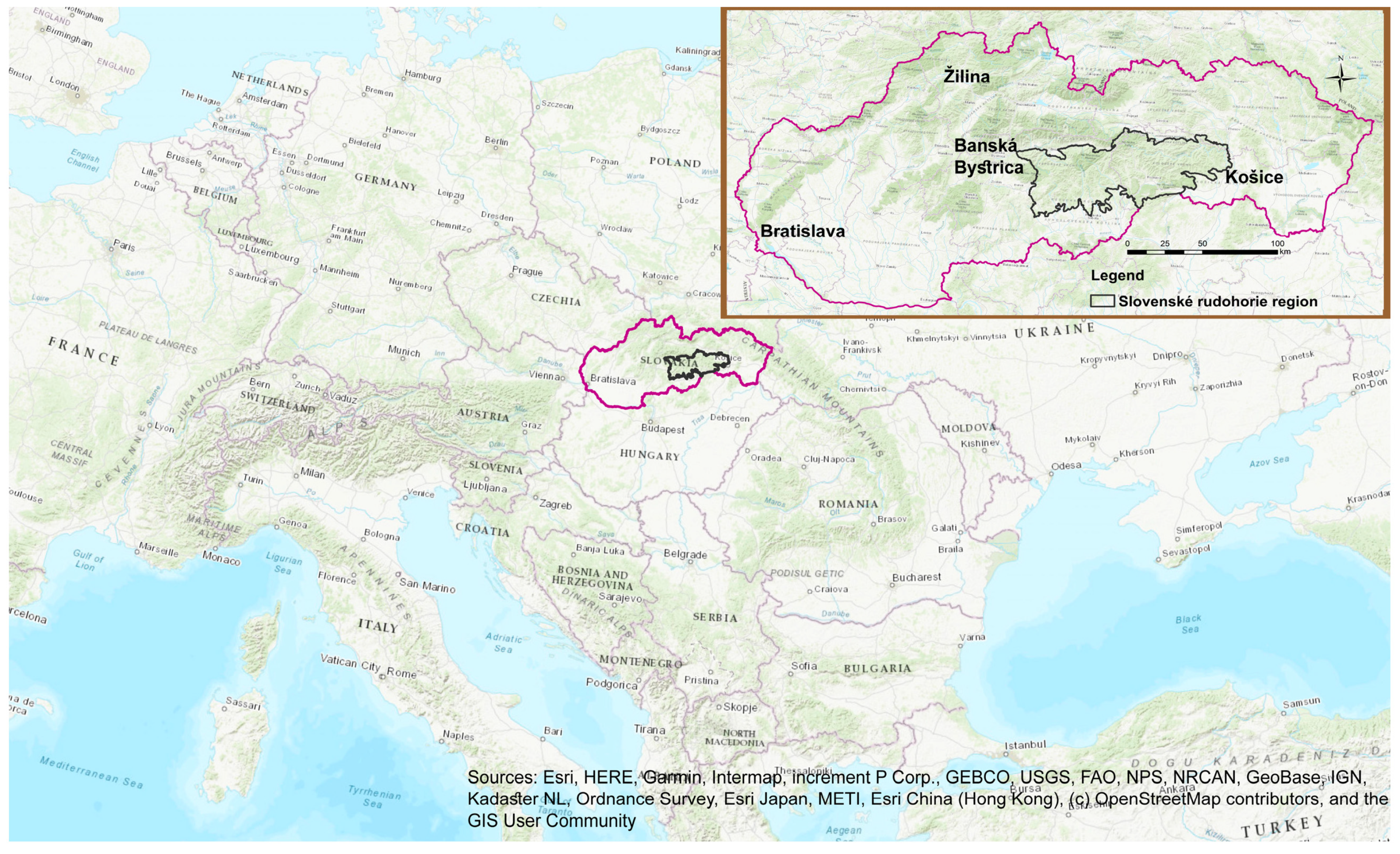
2. Study Area
3. Materials and Methods
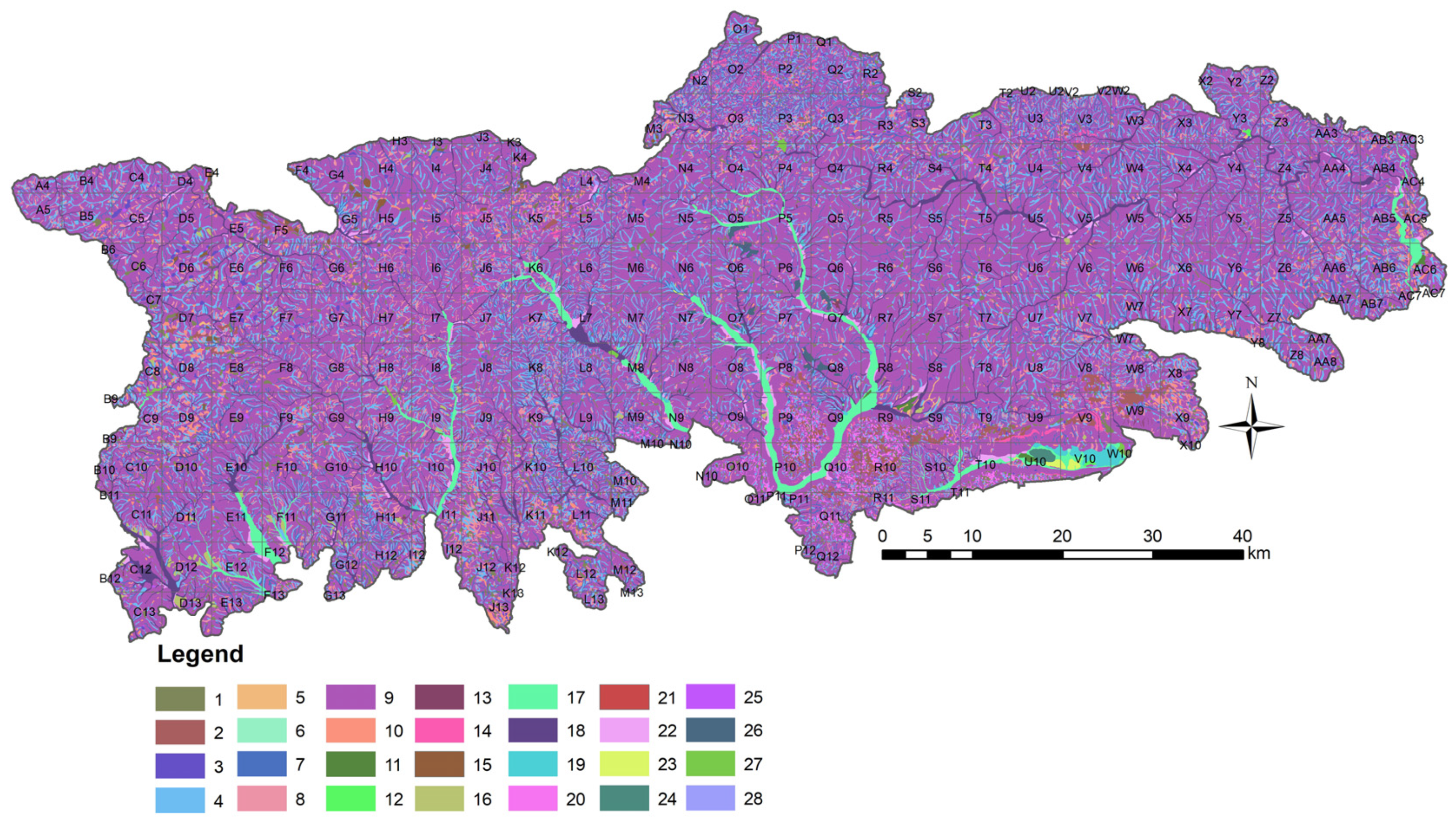
- Geological diversity (lithological units, stratigraphic representation, and 1:500,000 scale, according to Lexa et al. [76]);
- Tectonic diversity (tectonic units and 1:500,000 scale, according to Bezák et al. [77]);
- Geomorphological diversity (geomorphological subdivision, morphological-morphometric types, and 1:500,000 scale, according to Kočický et al. [78]);
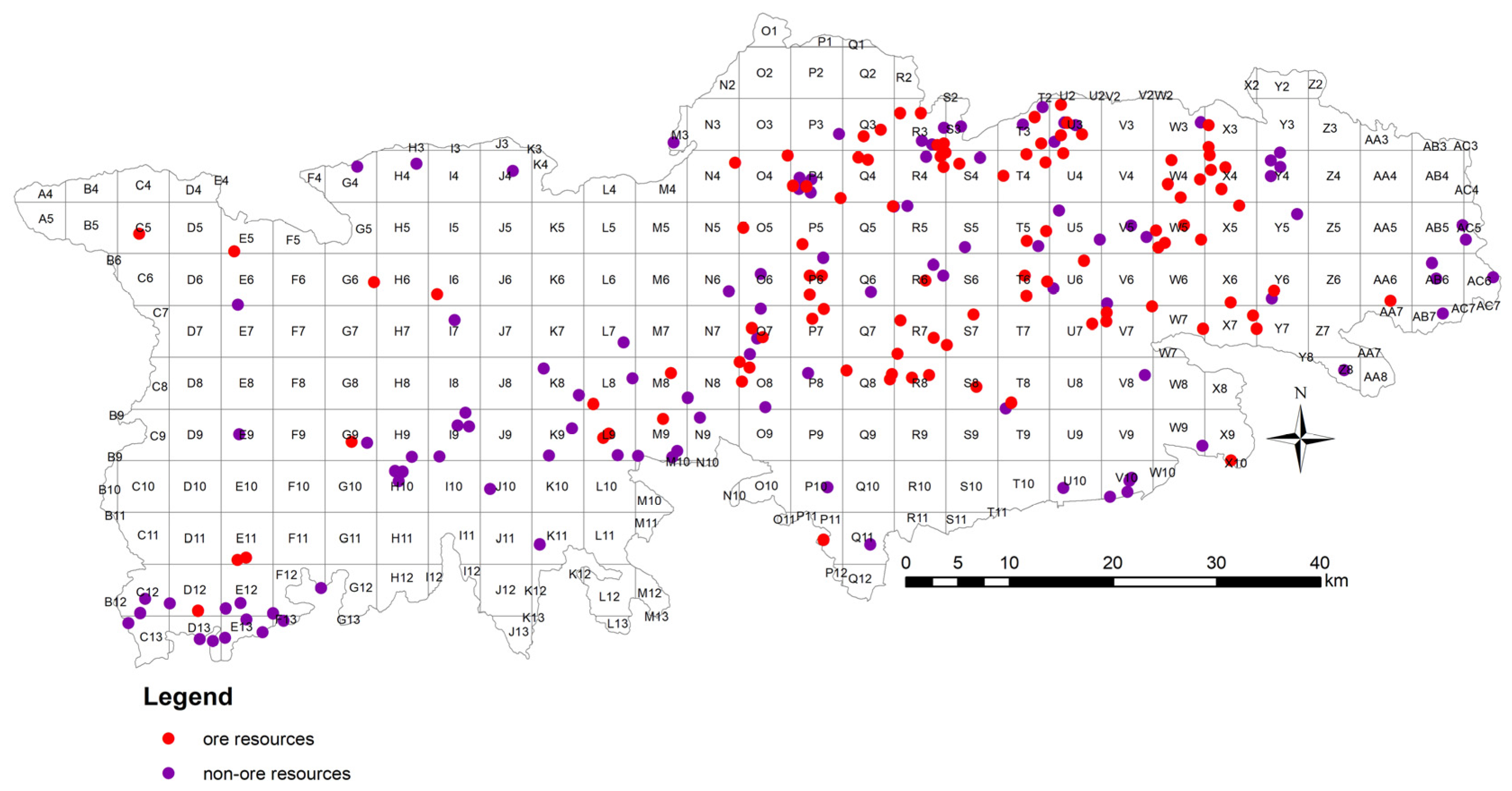
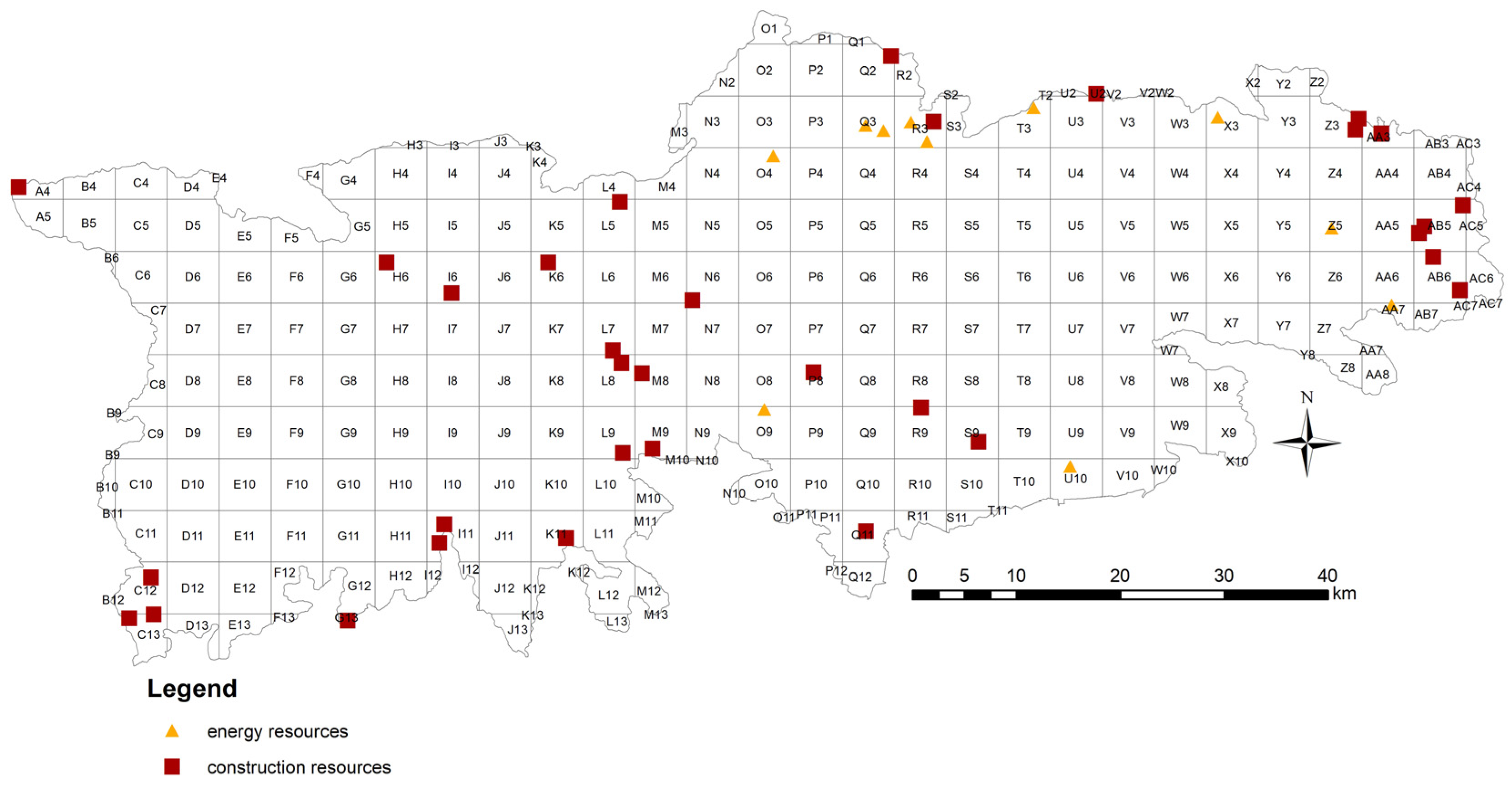
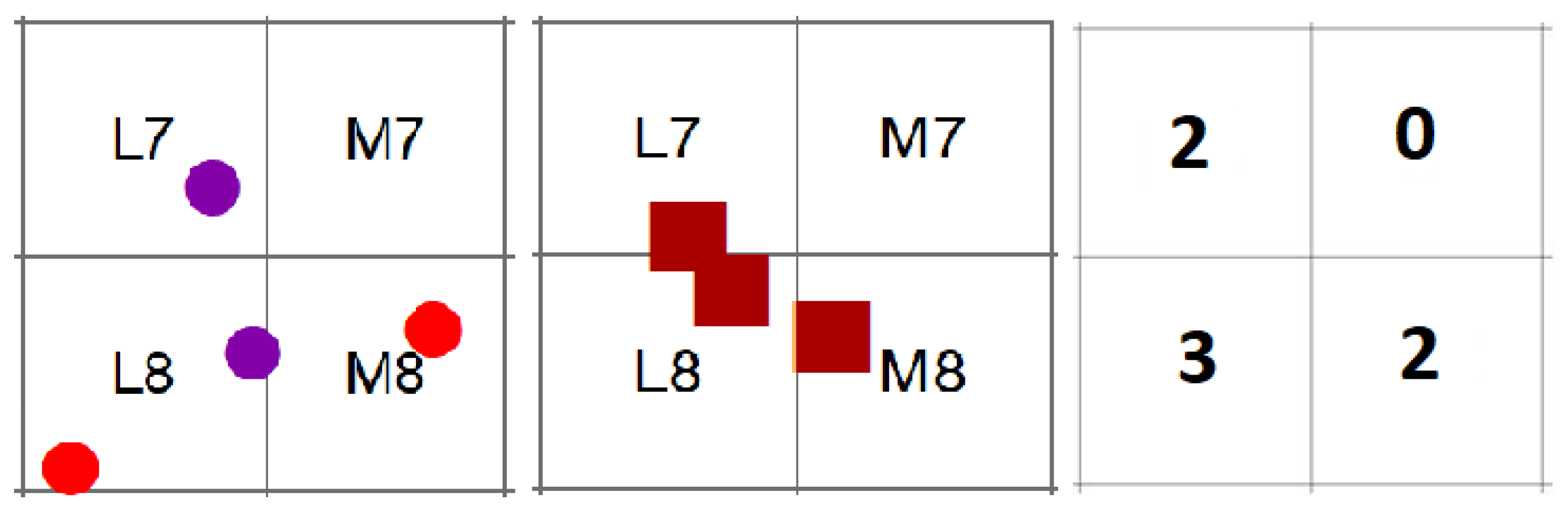
- Mineral resource diversity (ore, non-ore, energy and construction resources, and 1:500,000 scale, according to Zuberec et al. [83]).
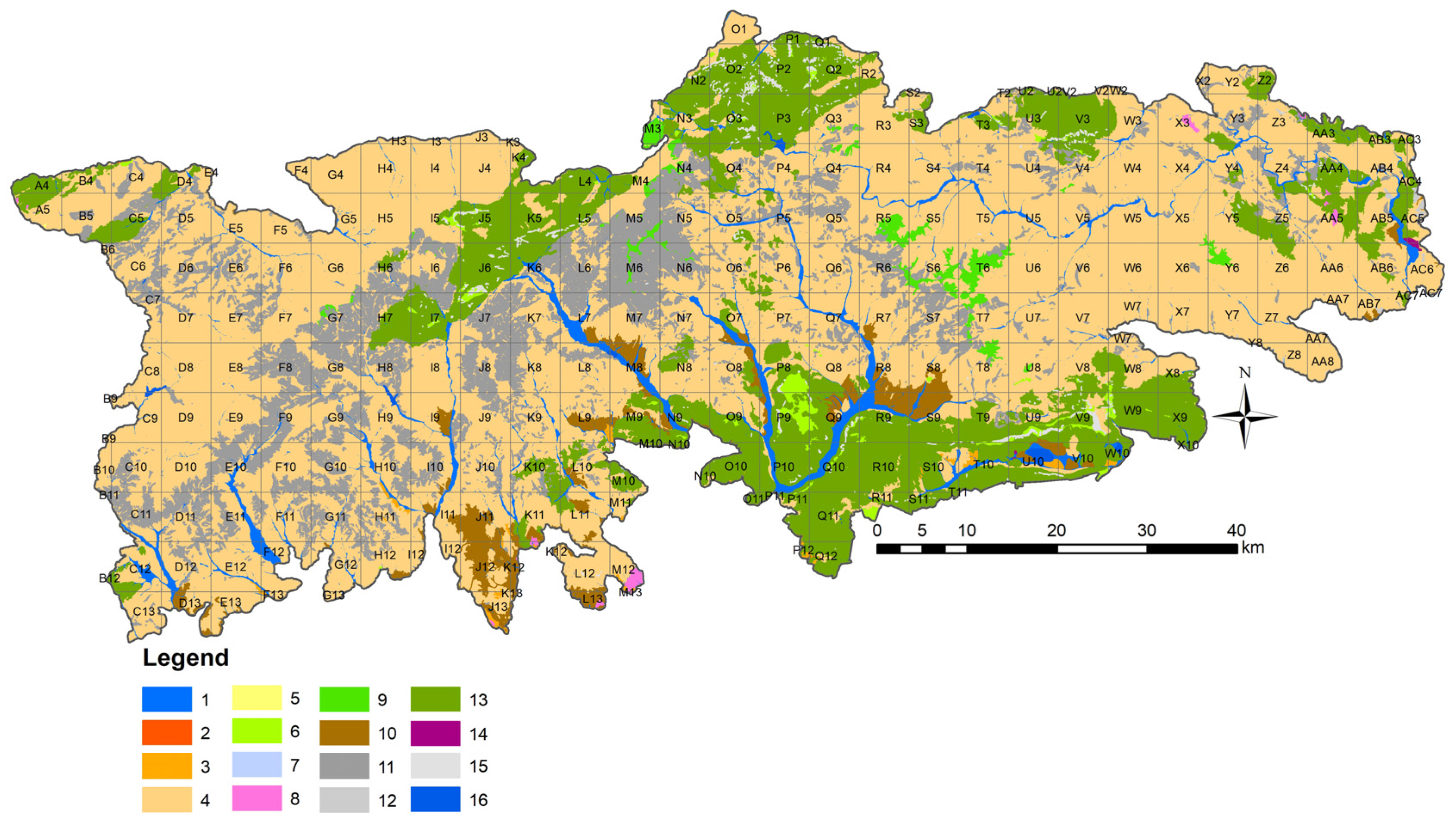
3.1. Geological Diversity
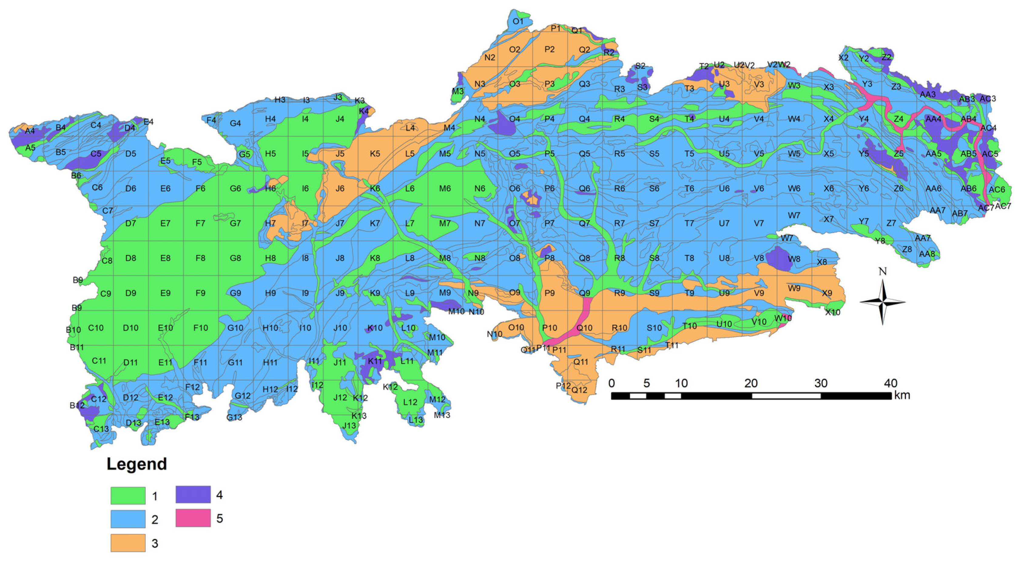
3.2. Tectonic Diversity
3.3. Geomorphological Diversity
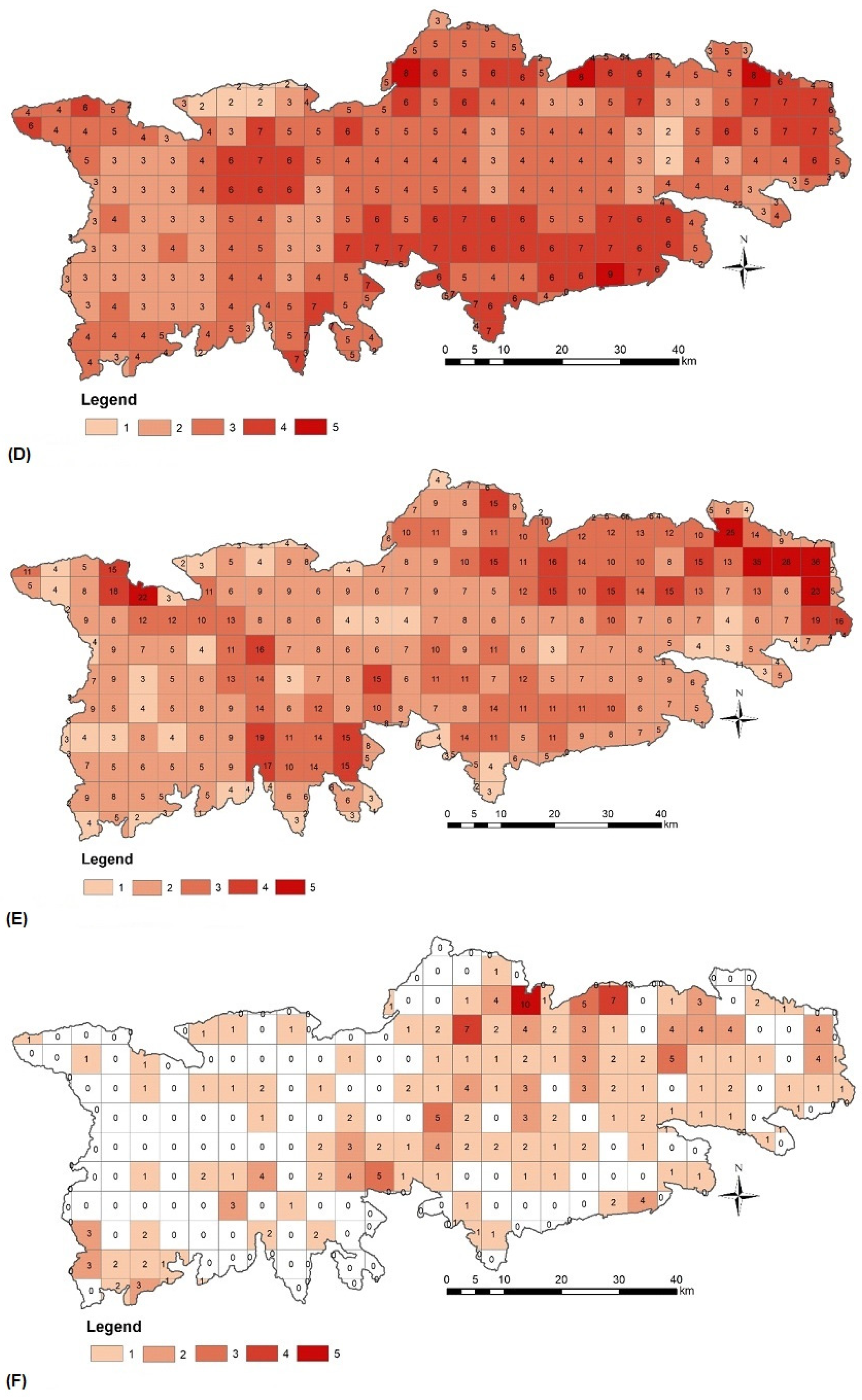
3.4. Soil Diversity
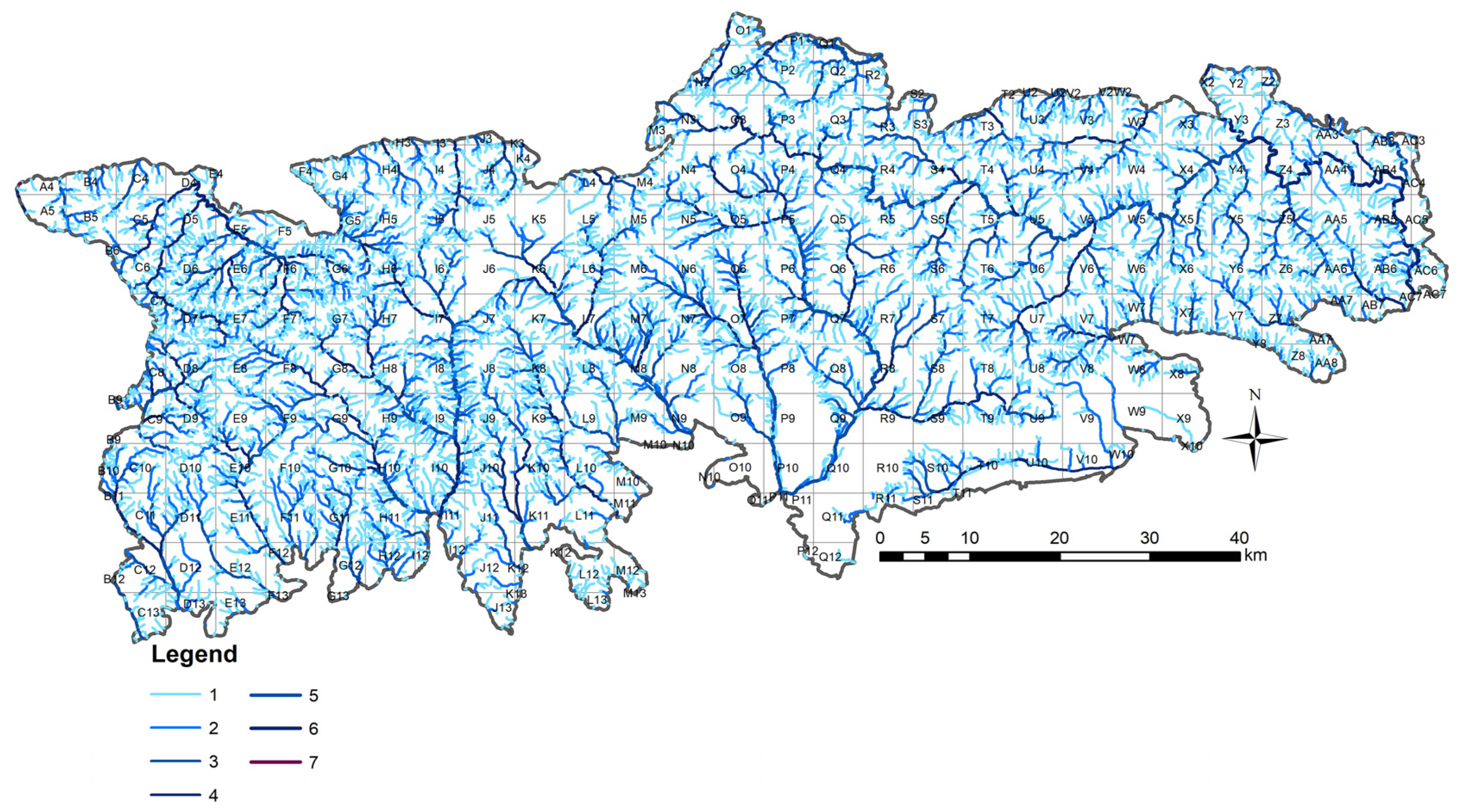
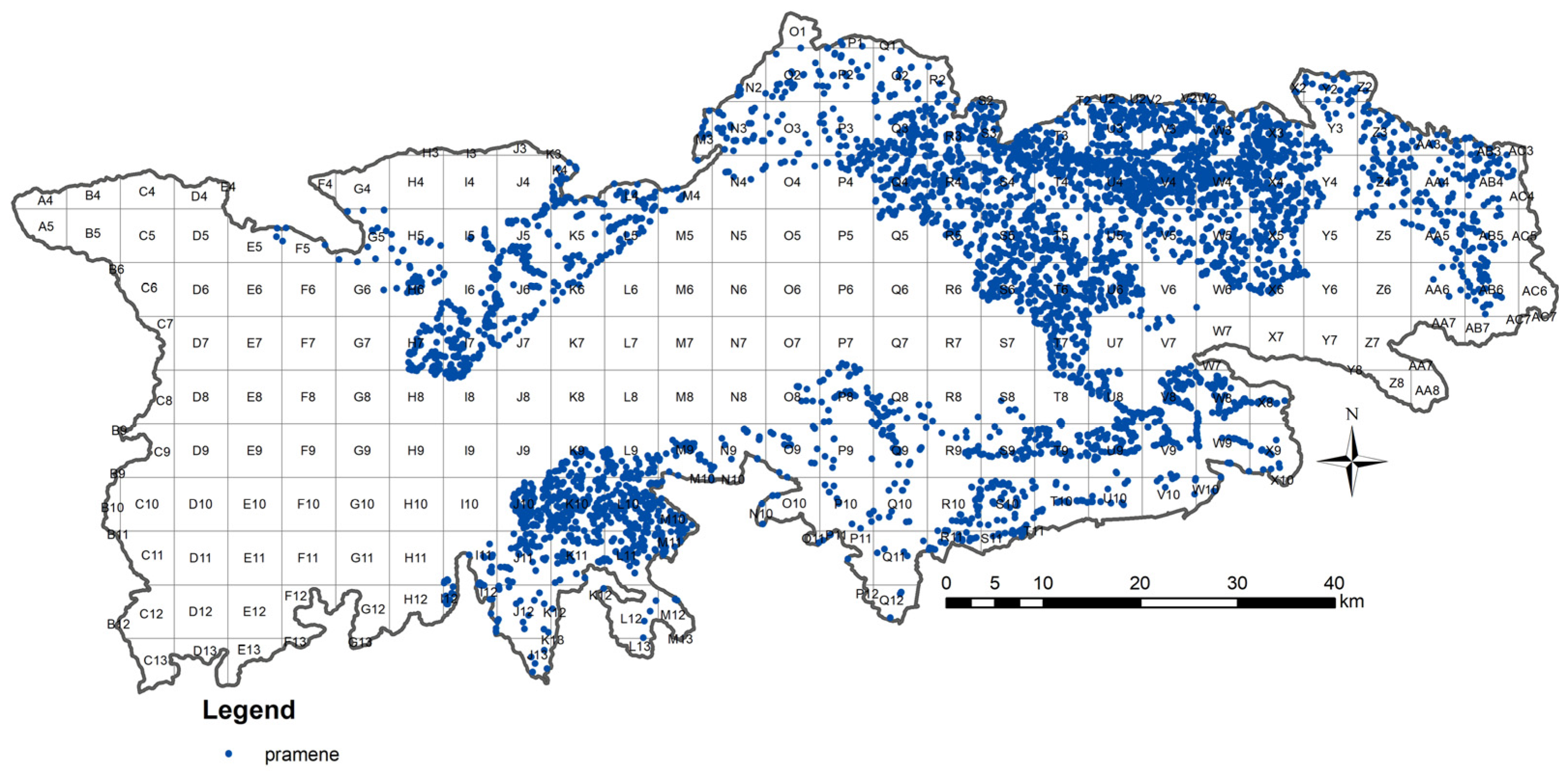
3.5. Hydrological Diversity
3.6. Mineral Resources Diversity
4. Results
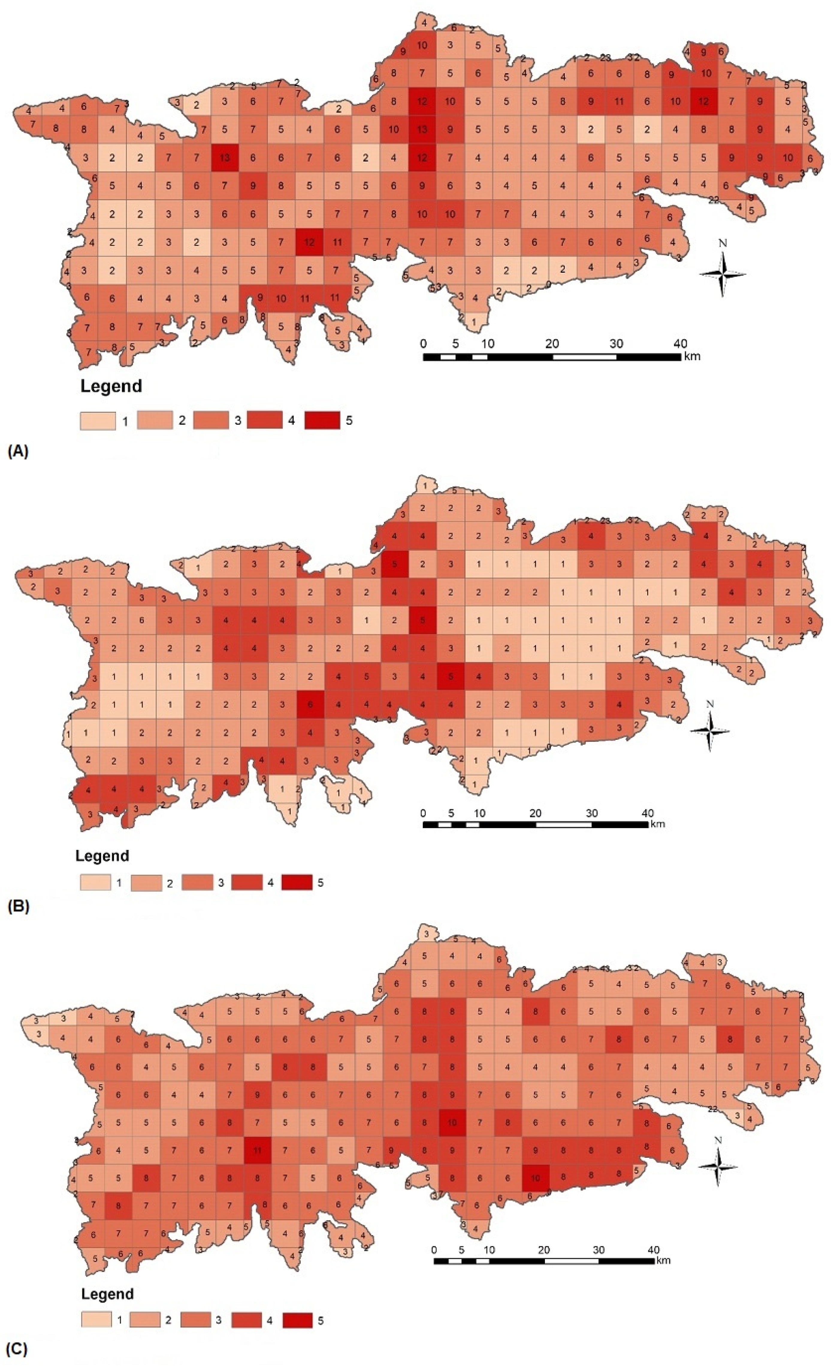
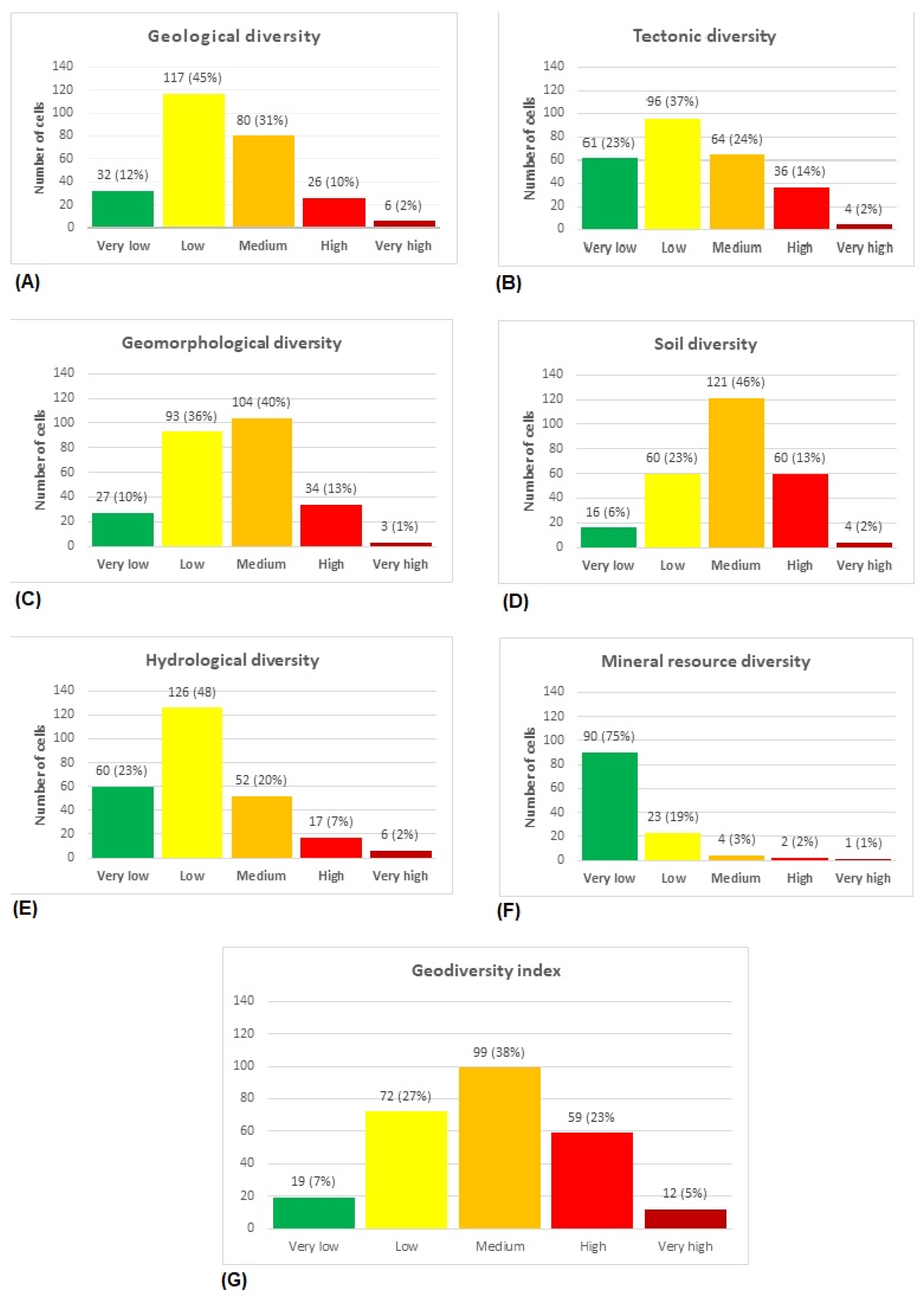
4.1. Geological Diversity Index
4.2. Tectonic Diversity Index
4.3. Geomorphological Diversity Index
4.4. Soil Diversity Index
4.5. Hydrological Diversity Index
4.6. Mineral Resource Diversity Index
4.7. Geodiversity Index
5. Discussion
5.1. Map Scales
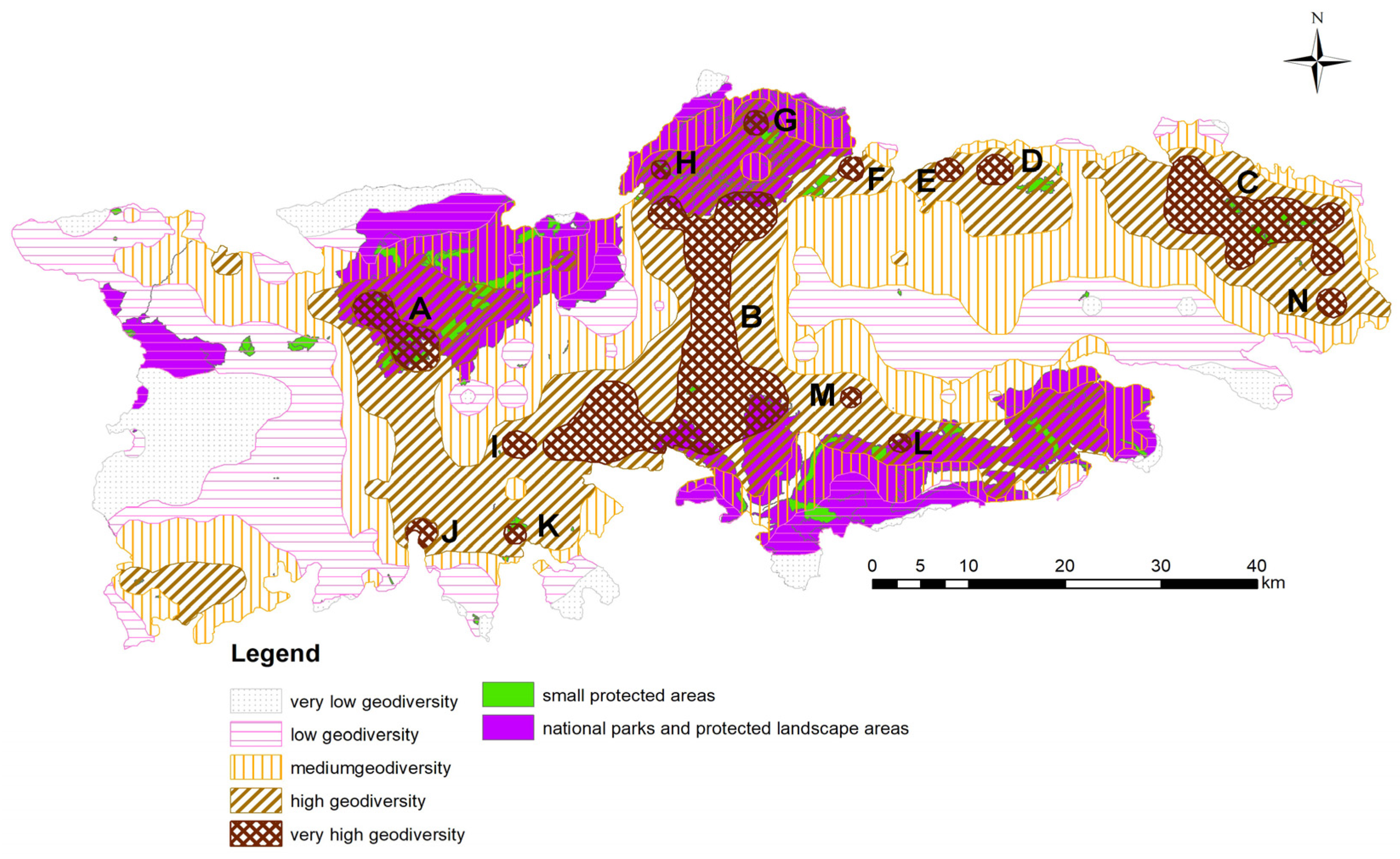
5.2. Geodiversity Indices and Sub-indices
5.3. Geodiversity vs. Biodiversity
5.4. Geoecosystem Services and Their Protection in Slovakia
6. Conclusions
Author Contributions
Funding
Data Availability Statement
Conflicts of Interest
References
- Tukiainen, H.; Toivanen, M.; Maliniemi, T. Geodiversity and Biodiversity. Geol. Soc. Lond. Spec. Publ. 2023, 530, 31–47. [Google Scholar] [CrossRef]
- Gray, M.; Gordon, J.E.; Brown, E.J. Geodiversity and the ecosystem approach: The contribution of geoscience in delivering integrated environmental management. Proc. Geol. Assoc. 2013, 124, 659–673. [Google Scholar] [CrossRef]
- Brilha, J.; Gray, M.; Pereira, D.I.; Pereira, P. Geodiversity: An integrative review as a contribution to the sustainable management of the whole of nature. Environ. Sci. Policy 2018, 86, 19–28. [Google Scholar] [CrossRef]
- Zwoliński, Z.; Najwer, A.; Giardino, M. Chapter 2—Methods for Assessing Geodiversity. In Geoheritage; Reynard, E., Brilha, J., Eds.; Elsevier: Amsterdam, The Netherlands, 2018; pp. 27–52. Available online: https://www.sciencedirect.com/science/article/pii/B9780128095317000022 (accessed on 27 May 2023).
- Gray, M. Geodiversity: Valuing and Conserving Abiotic Nature; John Wiley & Sons: Chichester, UK, 2004. [Google Scholar]
- Gray, M. Geodiversity: Developing the paradigm. Proc. Geol. Assoc. 2008, 119, 287–298. [Google Scholar] [CrossRef]
- Gray, M. Geodiversity: The origin and evolution of a paradigm. In History of Geoconservation; Burek, C.V., Prosser, C.D., Eds.; Geological Soc Publishing House: Bath, UK, 2008; Volume 300, pp. 31–36. Available online: https://www.webofscience.com/wos/woscc/summary/72a59c40-e6c2-4421-becc-4570533ffb34-6e8c2a4a/relevance/1 (accessed on 7 February 2023).
- Gray, M. Geodiversity: Valuing and Conserving Abiotic Nature, 2nd ed.; Wiley Blackwell: Chichester, UK, 2013. [Google Scholar]
- Hunter, M.L., Jr.; Jacobson, G.L., Jr.; Webb Iii, T. Paleoecology and the Coarse-Filter Approach to Maintaining Biological Diversity. Conserv. Biol. 1988, 2, 375–385. [Google Scholar] [CrossRef]
- Hjort, J.; Luoto, M. Geodiversity of high-latitude landscapes in northern Finland. Geomorphology 2010, 115, 109–116. [Google Scholar] [CrossRef]
- de Paula Silva, J.; Alves, G.B.; Ross, J.L.S.; Leite do Nascimento, M.A.; Felini, M.G.; Manosso, F.C.; Pereira, D.I. The Geodiversity of Brazil: Quantification, Distribution, and Implications for Conservation Areas. Geoheritage 2021, 13, 75. [Google Scholar] [CrossRef]
- Stein, A.; Gerstner, K.; Kreft, H. Environmental heterogeneity as a universal driver of species richness across taxa, biomes and spatial scales. Ecol. Lett. 2014, 17, 866–880. [Google Scholar] [CrossRef]
- Najwer, A.; Borysiak, J.; Gudowicz, J.; Mazurek, M.; Zwoliński, Z. Geodiversity and Biodiversity of the Postglacial Landscape (Dębnica River Catchment, Poland). Quaest. Geogr. 2016, 35, 5–28. [Google Scholar] [CrossRef]
- Wallis, C.I.B.; Tiede, Y.C.; Beck, E.; Böhning-Gaese, K.; Brandl, R. Biodiversity and ecosystem functions depend on environmental conditions and resources rather than the geodiversity of a tropical biodiversity hotspot. Sci. Rep. 2021, 11, 24530. [Google Scholar] [CrossRef]
- Sharples, C. Concepts and Principles of Geoconservation, 3rd ed.; Tasmanian Parks & Wildlife: Hobart, Australia, 2002; p. 81. [Google Scholar]
- Brilha, J. Inventory and Quantitative Assessment of Geosites and Geodiversity Sites: A Review. Geoheritage 2016, 8, 119–134. [Google Scholar] [CrossRef]
- Crisp, J.R.A.; Ellison, J.C.; Fischer, A.; Tan, J.S.D. Geodiversity inclusiveness in biodiversity assessment. Prog. Phys. Geogr. 2022, 47, 414–437. [Google Scholar] [CrossRef]
- Forte, J.P.; Brilha, J.; Pereira, D.I.; Nolasco, M. Kernel Density Applied to the Quantitative Assessment of Geodiversity. Geoheritage 2018, 10, 205–217. [Google Scholar] [CrossRef]
- Franca da Silva, J.M.; Cordeiro Santos, L.J.; Oka-Fiori, C. Spatial correlation analysis between topographic parameters for defining the geomorphometric diversity index: Application in the environmental protection area of the Serra da Esperanca (state of Parana, Brazil). Environ. Earth Sci. 2019, 78, 356. [Google Scholar] [CrossRef]
- Goncalves, J.; Mansur, K.; Santos, D.; Henriques, R.; Pereira, P. A Discussion on the Quantification and Classification of Geodiversity Indices Based on GIS Methodological Tests. Geoheritage 2020, 12, 38. [Google Scholar] [CrossRef]
- Manosso, F.C.; Zwolinski, Z.; Najwer, A.; Basso, B.T.; Santos, D.S.; Pagliarini, M. Spatial pattern of geodiversity assessment in the Marrecas River drainage basin, Parana, Brazil. Ecol. Indic. 2021, 126, 107703. [Google Scholar] [CrossRef]
- Zarnetske, P.L.; Read, Q.D.; Record, S.; Gaddis, K.D.; Pau, S.; Hobi, M.L.; Malone, S.L.; Constanza, J.; Dahlin, M.K.; Latimer, A.M.; et al. Towards connecting biodiversity and geodiversity across scales with satellite remote sensing. Glob. Ecol. Biogeogr. 2019, 28, 548–556. [Google Scholar] [CrossRef]
- Betard, F.; Peulvast, J.P. Geodiversity Hotspots: Concept, Method and Cartographic Application for Geoconservation Purposes at a Regional Scale. Environ. Manag. 2019, 63, 822–834. [Google Scholar] [CrossRef]
- Somma, R. The Inventory and Quantitative Assessment of Geodiversity as Strategic Tools for Promoting Sustainable Geoconservation and Geo-Education in the Peloritani Mountains (Italy). Educ. Sci. 2022, 12, 580. [Google Scholar] [CrossRef]
- Serrano, E.; Ruiz-Flaño, P. Geodiversity. A theoretical and applied concept. Geogr. Helv. 2007, 62, 140–147. [Google Scholar] [CrossRef]
- Serrano, E.; Ruiz-Flaño, P.; Arroyo, P. Geodiversity assessment in a rural landscape: Tiermes-Caracena area (Soria, Spain). Mem. Descr. Della Carta Geol. D’italia 2009, 87, 173–180. [Google Scholar]
- Danese, M.; Gioia, D.; Amodio, A.M.; Corrado, G.; Schiattarella, M. A Spatial Method for the Geodiversity Fragmentation Assessment of Basilicata Region, Southern Italy. In Computational Science and Its Applications, Iccsa 2021, Pt III; Springer: Cham, Switzerland, 2021; Volume 12951, pp. 620–631. [Google Scholar] [CrossRef]
- Ilic, M.M.; Stojkovic, S.; Rundic, L.; Calic, J.; Sandic, D. Application of the geodiversity index for the assessment of geodiversity in urban areas: An example of the Belgrade city area, Serbia. Geol. Croat. 2016, 69, 325–336. [Google Scholar] [CrossRef]
- Metsaots, K.; Printsmann, A.; Sepp, K. Public Opinions on Oil Shale Mining Heritage and its Tourism Potential. Scand. J. Hosp. Tour. 2015, 15, 380–399. [Google Scholar] [CrossRef]
- Benito-Calvo, A.; Perez-Gonzalez, A.; Magri, O.; Meza, P. Assessing regional geodiversity: The Iberian Peninsula. Earth Surf. Process. Landf. 2009, 34, 1433–1445. [Google Scholar] [CrossRef]
- Pereira, D.I.; Pereira, P.; Brilha, J.; Santos, L. Geodiversity Assessment of Parana State (Brazil): An Innovative Approach. Environ. Manag. 2013, 52, 541–552. [Google Scholar] [CrossRef]
- Silva, J.P.; Pereira, D.I.; Aguiar, A.M.; Rodrigues, C. Geodiversity assessment of the Xingu drainage basin. J. Maps 2013, 9, 254–262. [Google Scholar] [CrossRef]
- da Silva, M.L.N.; do Nascimento, M.A.L.; Mansur, K.L. Quantitative Assessments of Geodiversity in the Area of the Serido Geopark Project, Northeast Brazil: Grid and Centroid Analysis. Geoheritage 2019, 11, 1177–1186. [Google Scholar] [CrossRef]
- Sanz, J.; Zamalloa, T.; Maguregi, G.; Fernandez, L.; Echevarria, I. Educational Potential Assessment of Geodiversity Sites: A Proposal and a Case Study in the Basque Country (Spain). Geoheritage 2020, 12, 23. [Google Scholar] [CrossRef]
- Serrano Canadas, E.; Ruiz Flano, P. Geodiversity: Concept, assessment and Territorial Aplication. The Case of Tiermes-Caraciena (Soria). Bol. Asoc. Geogr. Esp. 2023, 79+. Available online: https://www.webofscience.com/wos/woscc/summary/40a4e242-61c0-46e5-abf1-45333dd9d627-6e9016ae/relevance/1 (accessed on 7 February 2023).
- Zakharovskyi, V.; Németh, K. Quantitative-Qualitative Method for Quick Assessment of Geodiversity. Land 2021, 10, 946. [Google Scholar] [CrossRef]
- Crisp, J.R.; Ellison, J.C.; Fischer, A. Current trends and future directions in quantitative geodiversity assessment. Prog. Phys. Geogr. Earth Environ. 2021, 45, 514–540. [Google Scholar] [CrossRef]
- Rybár, P.; Hronček, P. Historical blast furnace in Peklo valley of Ľubietová (Slovakia) and its reconstruction using 3D modelling. Acta. Montan. Slovaca 2016, 21, 333–341. [Google Scholar]
- Hronček, P.; Gregorová, B.; Tometzova, D.; Molokáč, M.; Hvizdák, L. Modeling of Vanished Historic Mining Landscape Features as a Part of Digital Cultural Heritage and Possibilities of Its Use in Mining Tourism (Case Study: Gelnica Town, Slovakia). Resources 2020, 9, 43. [Google Scholar] [CrossRef]
- Hvizdák, L.; Molokáč, M. Application of GIS to the model of the old mining objects and their exploitation in tourism. In Proceedings of the 12th International Multidisciplinary Scientific GeoConference, Albena, Bulgaria, 17–23 June 2012; Volume 4, pp. 965–972. [Google Scholar]
- Matlovič, R.; Matlovičová, K.; Kolesárová, J. Conceptualization of the historic mining towns in Slovakia in the institutional, urban-physiological and urban-morphological context. In Enhancing Competitiveness of V4 Historic Cities to Develop Tourism: Spatial-Economic Cohesion and Competitivness in the Context of Tourism; Radics, Z., Penczes, J., Eds.; Didakt Kft.: Debrecen, Hungary, 2014. [Google Scholar]
- Hronček, P.; Liga, J. Lost Mining Landscapes and Their Use in Geotourism. A Case Study from the Dolina Peklo—Hell Valley in the Central Slovakia. In Proceedings of the Geoconference on Ecology, Economics, Education and Legislation, Albena, Bulgaria, 17–26 June 2014; pp. 415–422. [Google Scholar]
- Rybár, P.; Molokáč, M.; Hvizdák, L.; Štrba, L.; Böhm, J. Upper Hungarian Mining Route. In Proceedings of the Geoconference on Ecology, Economics, Education and Legislation, Albena, Bulgaria, 17–26 June 2014; pp. 793–798. [Google Scholar]
- Hronček, P.; Rybár, P. Relics of manual rock disintegration in historical underground spaces and their presentation in mining tourism. Acta. Montan. Slovaca 2016, 21, 53–66. [Google Scholar]
- Weis, K.; Hronček, P.; Tometzová, D.; Gregorová, B.; Pribil, M.; Jesenský, M.; Čech, V. Analysis of notice boards (panels) as general information media in the outdoor mining tourism. Acta. Montan. Slovaca 2019, 24, 269–283. [Google Scholar]
- Rybár, P.; Molokáč, M.; Hvizdák, L.; Štrba, Ľ.; Böhm, J. Territory of Eastern Slovakia—Area of mining heritage of mediaeval mining. Acta Geoturistica 2012, 3, 7. [Google Scholar]
- Hronček, P.; Lukáč, M. Anthropogenically Created Historical Geological Surface Locations (geosites) and Their Protection. In Public Recreation and Landscape Protection—With Nature Hand in Hand! Fialova, I.J., Ed.; Mendel University in Brno: Brno, Czech Republic, 2018; pp. 54–60. [Google Scholar]
- Štrba, Ľ.; Kolačkovská, J.; Kudelas, D.; Kršák, B.; Sidor, C. Geoheritage and Geotourism Contribution to Tourism Development in Protected Areas of Slovakia—Theoretical Considerations. Sustainability 2020, 12, 2979. [Google Scholar] [CrossRef]
- Clarke, J.; Denman, R.; Hickman, G.; Slovak, J. Rural tourism in Rožňava okres: A Slovak case study. Tour. Manag. 2001, 22, 193–202. [Google Scholar] [CrossRef]
- Horvath, G.; Csuelloeg, G. A New Slovakian-Hungarian Cross-Border Geopark in Central Europe—Possibility for Promoting Better Connections Between the Two Countries. Eur. Countrys. 2013, 5, 146–162. [Google Scholar] [CrossRef]
- Veress, M.; Unger, Z. Baradla-Domica: Large Cave System on the Hungarian-Slovak Border. In Landscapes and Landforms of Hungary; Lóczy, D., Ed.; Springer International Publishing: Cham, Switzerland, 2015; pp. 167–175. [Google Scholar] [CrossRef]
- Telbisz, T.; Bottlik, Z.; Mari, L.; Petrvalská, A. Exploring Relationships Between Karst Terrains and Social Features by the Example of Gömör-Torna Karst (Hungary-Slovakia). Acta Carsologica 2015, 44, 121–137. [Google Scholar] [CrossRef]
- Telbisz, T.; Gruber, P.; Mari, L.; Köszegi, M.; Bottlik, Z.; Standovár, T. Geological Heritage, Geotourism and Local Development in Aggtelek National Park (NE Hungary). Geoheritage 2020, 12, 5. [Google Scholar] [CrossRef]
- Telbisz, T.; Mari, L.; Gessert, A.; Nestorová Dická, J.; Gruber, P. Attitudes and perceptions of local residents and tourists—A comparative study of the twin national parks of Aggtelek (Hungary) and Slovak Karst (Slovakia). Acta Carsologica 2022, 51, 93–109. [Google Scholar] [CrossRef]
- Stoffelen, A.; Vanneste, D. An integrative geotourism approach: Bridging conflicts in tourism landscape research. Tour. Geogr. 2015, 17, 544–560. [Google Scholar] [CrossRef]
- Pralong, J.P. Geotourism: A new Form of Tourism utilising natural Landscapes and based on Imagination and Emotion. Tour. Rev. 2006, 61, 20–25. [Google Scholar] [CrossRef]
- Hose, T.A. Towards a history of geotourism: Definitions, antecedents and the future. Geol. Soc. Lond. Spec. Publ. 2008, 300, 37–60. [Google Scholar] [CrossRef]
- Dowling, R.K. Global Geotourism—An Emerging Form of Sustainable Tourism. Czech J. Tour. 2013, 2, 59–79. [Google Scholar] [CrossRef]
- Dowling, R.; Newsome, D. (Eds.) Handbook of Geotourism; Edward Elgar Publishing Ltd.: Cheltenham, UK, 2018; Available online: https://www.webofscience.com/wos/woscc/summary/80494a9b-1b47-4bed-b132-6d0e10f3754b-82bd2f41/relevance/1 (accessed on 17 April 2023).
- Ahmadi, M.; Mokhtari, D.; Khodadadi, M.; Shahabi, H. Geodiversity evaluation and geoconservation using grid analysis: Case study, north of Ilam Province. Appl. Geomat. 2021, 13, 537–553. [Google Scholar] [CrossRef]
- Ahmadi, M.; Derafshi, K.; Mokhtari, D.; Khodadadi, M.; Najafi, E. Geodiversity Assessments and Geoconservation in the Northwest of Zagros Mountain Range, Iran: Grid and Fuzzy Method Analysis. Geoheritage 2022, 14, 132. [Google Scholar] [CrossRef]
- Antic, A.; Peppoloni, S.; Di Capua, G. Applying the Values of Geoethics for Sustainable Speleotourism Development. Geoheritage 2020, 12, 73. [Google Scholar] [CrossRef]
- Nikitina, N. Geodiversity, and the geoethical principles for its preservation. Ann. Geophys. 2012, 55, 497–500. [Google Scholar] [CrossRef]
- da Silva, C.M. Urban Geodiversity and Decorative Arts: The Curious Case of the ‘Rudist Tiles’ of Lisbon (Portugal). Geoheritage 2019, 11, 151–163. [Google Scholar] [CrossRef]
- da Silva, C.M. Geodiversity and Sense of Place: Local Identity Geological Elements in Portuguese Municipal Heraldry. Geoheritage 2019, 11, 949–960. [Google Scholar] [CrossRef]
- Herrera-Franco, G.; Carrión-Mero, P.; Alvarado, N.; Morante-Carballo, F.; Maldonado, A.; Caldevilla, P.; Briones-Bitar, J.; Berrezueta, E. Geosites and Georesources to Foster Geotourism in Communities: Case Study of the Santa Elena Peninsula Geopark Project in Ecuador. Sustainability 2020, 12, 4484. [Google Scholar] [CrossRef]
- Erikstad, L. Geoheritage and geodiversity management—The questions for tomorrow. Proc. Geol. Assoc. 2013, 124, 713–719. [Google Scholar] [CrossRef]
- Carvalhido, R.J.; Brilha, J.B.; Pereira, D.I. Designation of Natural Monuments by the Local Administration: The Example of Viana Do Castelo Municipality and its Engagement with Geoconservation (NW Portugal). Geoheritage 2016, 8, 279–290. [Google Scholar] [CrossRef]
- Bouzekraoui, H.; Barakat, A.; El Youssi, M.; Touhami, F.; Mouaddine, A.; Hafid, A.; Zwolinski, Z. Mapping Geosites as Gateways to the Geotourism Management in Central High-Atlas (morocco). Quaest. Geogr. 2018, 37, 87–102. [Google Scholar] [CrossRef]
- Aldighieri, B.; Testa, B.; Bertini, A. 3D Exploration of the San Lucano Valley: Virtual Geo-routes for Everyone Who Would Like to Understand the Landscape of the Dolomites. Geoheritage 2016, 1, 77–90. [Google Scholar] [CrossRef]
- Comanescu, L.; Nedelea, A. The assessment of geodiversity—A premise for declaring the geopark Buzului County (Romania). J. Earth Syst. Sci. 2012, 121, 1493–1500. [Google Scholar] [CrossRef]
- Eder, W. Geoparks—Promotion of Earth Sciences through Geoheritage Conservation, Education and Tourism. J. Geol. Soc. India 2008, 72, 149–154. [Google Scholar]
- Farsani, N.T.; Coelho, C.; Costa, C. Geotourism and Geoparks as Novel Strategies for Socio-economic Development in Rural Areas. Int. J. Tour. Res. 2011, 13, 68–81. [Google Scholar] [CrossRef]
- Ruban, D.A. Water in Descriptions of Global Geoparks: Not Less Important than Geology? Water 2019, 11, 1866. [Google Scholar] [CrossRef]
- Santos, D.S.; Mansur, K.L.; Gonçalves, J.B.; Arruda, E.R.; Manosso, F.C. Quantitative assessment of geodiversity and urban growth impacts in Armação dos Búzios, Rio de Janeiro, Brazil. Appl. Geogr. 2017, 85, 184–195. [Google Scholar] [CrossRef]
- Lexa, J.; Bezák, V.; Elečko, M.; Mello, J.; Polák, M.; Potfaj, M.; Vozár, J.; Eliáš, M.; Konečný, V.; Less, G.; et al. Geologická Mapa Západných Karpát a Priľahlých území 1: 500 000 [Online]; Štátny Geologický Ústav Dionýza Štúra: Bratislava, Slovakia, 2000; Available online: https://apl.geology.sk/mapportal/indexn.html#/inspire/31 (accessed on 6 February 2023).
- Bezák, V.; Broska, I.; Ivanička, J.; Reichwalder, P.; Vozár, J.; Polák, M.; Havrila, M.; Mello, J.; Biely, A.; Plašienka, D.; et al. Tektonická Mapa Slovenskej Republiky [Online]; Štátny Geologický Ústav Dionýza Štúra: Bratislava, Slovakia, 2014; Available online: https://apl.geology.sk/mapportal/indexn.html#/inspire/6 (accessed on 13 February 2023).
- Kočický, D.; Ivanič, B. Geomorfologické členenie Slovenska [Online]; Štátny Geologický Ústav Dionýza Štúra: Bratislava, Slovakia, 2014; Available online: https://apl.geology.sk/mapportal/indexn.html#/inspire/24 (accessed on 17 February 2023).
- ESPRIT Spol. s. r.o. Soil Units–Map Layer in Shp Format; Esprit Internal Database: online, 2023. [Google Scholar]
- SSCRI. Morfogenetický Klasifikačný Systém Pôd Slovenska: Bazálna Referenčná Taxonómia; 2. Uprav. Vyd.; Výskumný Ústav Pôdoznalectva a Ochrany Pôdy NPPC: Bratislava, Slovakia, 2014. [Google Scholar]
- Hydrogeologické Mapy [Online]; Štátny Geologický ÚSTAV DIONÝZA ŠTÚRA: Bratislava, Slovakia, 2008; Available online: https://apl.geology.sk/mapportal/indexn.html#/inspire/40 (accessed on 20 February 2023).
- ESPRIT Spol. s. r.o. Segmental River Network–Map Layer in shp Format; Esprit Internal Database: online, 2023. [Google Scholar]
- Zuberec, J.; Tréger, M.; Lexa, J.; Baláž, P. Nerastné Suroviny Slovenska [Online]; Štátny Geologický Ústav Dionýza Štúra: Bratislava, Slovakia, 2014; Available online: https://apl.geology.sk/mapportal/indexn.html#/inspire/33 (accessed on 23 February 2023).
- de Paula Silva, J.; Rodrigues, C.; Pereira, D.I. Mapping and Analysis of Geodiversity Indices in the Xingu River Basin, Amazonia, Brazil. Geoheritage 2015, 7, 337–350. [Google Scholar] [CrossRef]
- Araujo, A.M.; Pereira, D.Í. A New Methodological Contribution for the Geodiversity Assessment: Applicability to Ceará State (Brazil). Geoheritage 2018, 10, 591–605. [Google Scholar] [CrossRef]
- Fernández, A.; Fernández, T.; Pereira, D.I.; Nieto, L.M. Assessment of Geodiversity in the Southern Part of the Central Iberian Zone (Jaén Province): Usefulness for Delimiting and Managing Natural Protected Areas. Geoheritage 2020, 12, 20. [Google Scholar] [CrossRef]
- Carrión-Mero, P.; Dueñas-Tovar, J.; Jaya-Montalvo, M.; Berrezueta, E.; Jiménez-Orellana, N. Geodiversity assessment to regional scale: Ecuador as a case study. Environ. Sci. Policy 2022, 136, 167–186. [Google Scholar] [CrossRef]
- Urquí, L.C. Patrimonio Geológico y Geodiversidad; IGME: Madrid, Spain, 2007. [Google Scholar]
- Stavi, I.; Rachmilevitch, S.; Yizhaq, H. Geodiversity effects on soil quality and geo-ecosystem functioning in drylands. CATENA 2019, 176, 372–380. [Google Scholar] [CrossRef]
- Stavi, I.; Yizhaq, H.; Szitenberg, A.; Zaady, E. Patch-scale to hillslope-scale geodiversity alleviates susceptibility of dryland ecosystems to climate change: Insights from the Israeli Negev. Curr. Opin. Environ. Sustain. 2021, 50, 129–137. [Google Scholar] [CrossRef]


| Degree | Category 1 Flow Length of Flows (in m), 1st and 2nd Tier Flows | Category 2 Flow Length of Flows (in m), 3rd, 4th, 5th, 6th, and 7th Tier Flows |
|---|---|---|
| 0 | 0 | 0 |
| 1 | 1–11,000 | 1–2400 |
| 2 | 11,001–22,000 | 2401–4800 |
| 3 | 22,001–33,000 | 4801–7200 |
| 4 | 33,001–44,000 | 7201–9600 |
| 5 | above 44,001 | above 9601 |
Disclaimer/Publisher’s Note: The statements, opinions and data contained in all publications are solely those of the individual author(s) and contributor(s) and not of MDPI and/or the editor(s). MDPI and/or the editor(s) disclaim responsibility for any injury to people or property resulting from any ideas, methods, instructions or products referred to in the content. |
© 2023 by the authors. Licensee MDPI, Basel, Switzerland. This article is an open access article distributed under the terms and conditions of the Creative Commons Attribution (CC BY) license (https://creativecommons.org/licenses/by/4.0/).
Share and Cite
Barančoková, M.; Hutárová, D.; Nikolaj, M. Quantitative Assessment of Geodiversity for Conservation Purposes in Slovenské rudohorie Mountains (Slovakia). Land 2023, 12, 1650. https://doi.org/10.3390/land12091650
Barančoková M, Hutárová D, Nikolaj M. Quantitative Assessment of Geodiversity for Conservation Purposes in Slovenské rudohorie Mountains (Slovakia). Land. 2023; 12(9):1650. https://doi.org/10.3390/land12091650
Chicago/Turabian StyleBarančoková, Mária, Daniela Hutárová, and Maroš Nikolaj. 2023. "Quantitative Assessment of Geodiversity for Conservation Purposes in Slovenské rudohorie Mountains (Slovakia)" Land 12, no. 9: 1650. https://doi.org/10.3390/land12091650
APA StyleBarančoková, M., Hutárová, D., & Nikolaj, M. (2023). Quantitative Assessment of Geodiversity for Conservation Purposes in Slovenské rudohorie Mountains (Slovakia). Land, 12(9), 1650. https://doi.org/10.3390/land12091650