Abstract
The rapid urbanization and population growth in China have brought the issues of social equity and justice to the forefront. The supply and layout of public service facilities play a crucial role in determining the residents’ quality of life and have become a significant factor triggering social equity and justice concerns. This study took Zhengzhou’s urban core as an example. From the perspectives of regional equality, spatial equity, and social justice, the service area analysis and Gaussian two-step floating catchment area method were used to analyze the public service facilities’ layout situation and the equity and justice issue and to discuss the causes of the current situation. The study found that the social equity and justice of public facilities in Zhengzhou’s urban core were more prominent. The accessibility of public facilities inside and outside the 3rd ring road of the urban core exhibited marked differences, indicating a need for improvement in regional equality and spatial equity. Vulnerable groups lacked special care and public facilities lacked justice. Combined with the development process of urbanization in Zhengzhou, this paper argued that this was closely related to the government’s public policies.
1. Introduction
Public service facilities provide essential support for urban and social development. They provide residents with basic services and benefits, such as housing, transportation, hydropower, education, and health. The supply and layout of public service facilities directly impact the residents’ quality of life. With the world economy and urbanization rapidly developing, the urban population has increased dramatically [1]. However, the urbanization of infrastructure lagging behind population growth has caused problems such as difficulty accessing education and medical care, a shortage of public cultural products [2], residential segregation [3], widening wealth gaps [4], and increasing social disharmony. How to solve these problems and build a sustainable city and society is a challenge for governments. The United Nations adopted the “New Urban Agenda” in 2016, which emphasized the key role of public service facilities in achieving sustainable development goals and proposed a series of principles and commitments to promote the equity and sustainability of public service facilities [5]. To realize sustainable urbanization, scholars across disciplines have extensively researched public service facilities. Zhang [6], Zheng [7], Shi [8], and Xu [9] researched layout optimization and constructed the optimization framework for green space, drainage, and transportation facilities. Vu [10] and Yang [11] gave suggestions for the sustainable development of public facilities management from the management perspective. Cumming [12] studied the case of investing in ecological infrastructure to achieve sustainable development goals. As an aspect of socially sustainable development [13], some scholars have studied public facilities from the perspective of equity and justice.
Western scholars first carried out relevant research. Hakimi [14,15], Church [16], and others designed various models based on geographic location theory to study public service facility layout. Mumphrey [17], Mcallister [18], and Savas [19] introduced equity in public facility location studies. Since the adoption of the Rio de Janeiro declaration by the United Nations, sustainable development has gradually become the consensus of national development [20]. Joseph [21] used a gravitational potential model to analyze the accessibility of medical facilities in rural areas and discussed inequity in access to medical care. Talen [22] used gravity potential, average travel distance, and nearest distance as accessibility indicators to analyze the equity in recreational facility layout. The 2030 Agenda for Sustainable Development, adopted in 2015, explicitly stated goals to ensure equitable access to basic services for all men and women, in particular the poor and the vulnerable. Scholars across disciplines have extensively conducted research on the equity of public facilities based on accessibility, focusing on green spaces [23,24] and medical facilities [25]. A series of accessibility research methods have been utilized, including buffer analysis [26], network analysis [27], a gravity model [21], the weighted distance method [28], and the two-step floating catchment area method [29], each with its focus. In recent years, some scholars have applied the Gini coefficient [30], spatial syntax [31,32], spatial autocorrelation analysis [33], and other methods to public facility study. Chinese scholars’ research on public facilities mainly focused on distribution in the early days and began to pay attention to equity and justice in recent years. Gao [34] studied the spatial distribution characteristics and allocation methods of public facilities in Guangzhou. Luo [35] explored the uneven distribution of public facilities in Chengdu from a residential segregation perspective and found significant differences in access for different social groups to public facility services. Wang [36] conducted an equity performance evaluation of sports facilities in Shanghai from a health equity perspective. They believed that when allocating public facilities, we should consider not only their presence but also how well they match population needs. Wang [37] explored the effects of public facility accessibility and individual social capital, as well as their interaction with residents’ mental health. They argue that future urban planning should address these factors to promote equitable access to public services for different social groups.
Summarizing relevant research on equity and justice in public facilities, the research scale has evolved from the large-scale administrative district level to the small-scale street and community level. Research methods have evolved from early theoretical analysis and model construction to current accessibility methods. Research objects have mainly focused on equity and justice for specific public facilities such as green spaces, hospitals, and schools but lacked analysis of the overall layout within a region [34,38,39,40]. Regarding the research subject, current studies treat residents of all ages as a homogeneous group or focus on specific groups such as seniors or disabled individuals while lacking comparisons among different age groups. However, the research perspective and depth were relatively narrow and lacked a multidimensional comprehensive analysis of equity and justice. Most research stopped on equity results and lacked discussion on the causes behind the phenomenon.
According to the National Bureau of Statistics of China, the Gini coefficient of Chinese residents’ per capita disposable income in 2020 was 0.468, exceeding the internationally recognized warning line of 0.4 [5]. The Chinese government has stated that equitable access to fundamental public services is crucial for achieving common prosperity. Since being included in national central cities in 2016, Zhengzhou has made efforts to promote the internationalization of the living environment, constantly improve its infrastructure construction, and accelerate the construction of public transportation, green spaces, public health services, and other public service facilities and gradually improve the modern public facilities system. However, as a regional central city, Zhengzhou still faces challenges such as uncoordinated development between regions, large income gaps between rich and poor individuals, a low proportion of tertiary industry, and the neglect of public interests in urban planning [41]. Achieving sustainable urbanization requires addressing social equity and justice issues such as potential imbalances between population and public resources, low urban governance capacity, and the increasing wealth gap [42,43,44]. Based on summarizing the existing research, this study broke through the disadvantages of a single perspective from three perspectives: regional equality, spatial equity, and social justice. In the calculation process, this study used a mature accessibility calculation method, service area analysis, and the Gaussian two-step floating catchment area method and uses time cost instead of traditional distance cost to obtain the per land and per capita comprehensive accessibility of public service facilities. According to the accessibility results, we analyze the current public service facility layout and allocation situation, focus on equity and justice issues in the current facility layout, and make recommendations for optimizing public service facilities to provide a theoretical reference for the location planning of public service facilities in areas with a high cost of investment and construction similar to Zhengzhou.
2. Materials and Methods
2.1. Description of the Study Area
Zhengzhou is located in north-central Henan Province at the middle and lower reaches of the Yellow River. It is an important node city of “the Belt and Road Initiatives” and an important international modernized three-dimensional comprehensive transportation hub in China. The study focuses on Zhengzhou’s urban core, mainly referring to its five administrative districts: Jinshui, Zhongyuan, Erqi, Guancheng, and Huiji (Figure 1). Since the Reform and Opening Up, the urbanization process of Zhengzhou has accelerated. By the end of 2020, Zhengzhou’s urban core had a permanent population of 7.033 million and a total output value of 667.51 billion yuan.
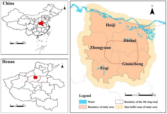
Figure 1.
Location of the study area.
2.2. Data Sources
Public service facilities provide various public goods and services for residents’ daily life [45]. They are divided into fixed-point, non-fixed-point, and network public service facilities due to the difference in location attributes [46]. Fixed-point public service facilities such as hospitals, schools, parks, and sports grounds have the characteristic that the benefits decrease with increasing distance. Therefore, the planning and location of fixed-point public service facilities directly affect their location and quantity, which then are expressed through differences in resident accessibility, eventually leading to inequity in resident enjoyment of public service facilities and affecting equity in public services. When discussing equity and justice in public service facilities, this study mainly refers to fixed-point public service facilities, hereinafter referred to as public facilities. Public facility data in this paper is POI data for eight types of fixed-point public facilities in Zhengzhou’s urban core by the end of 2020, namely, finance service facilities, green space facilities, sports facilities, transportation facilities, culture facilities, shopping facilities, educational facilities, and medical facilities (as shown in Table 1), and the data source is Gaode Map (https://ditu.amap.com/ (accessed on 26 June 2022)). Considering the edge effect, where people may cross regions for medical treatment, schooling, shopping, etc., public facilities within a 3 km buffer distance outside the study area are included in the calculations [47]. The POI data were checked and censored for duplicates or shifted in position using satellite image data. Since public facilities are faceted buildings, POI data in this paper represent entrances to public facilities and multiple entrances are retained according to actual needs.

Table 1.
Concrete types of public facilities and search thresholds.
Population data was obtained from the demographic website WorldPop (http://hub.worldpop.org/ (accessed on 3 June 2022). WorldPop is an open-source population spatial dataset that provides the public with free high-resolution population spatial distribution data. Its data have been downloaded and used by researchers and policymakers worldwide.
2.3. Methods
2.3.1. Conceptual Framework
Since the Reform and Opening Up, China’s built-up area has rapidly expanded. Rapid urban population growth and social economic development have urged the government to address social equity and justice in public resource allocation while pursuing economic interests. In recent years, research and evaluation methods for equity and justice in public facilities have emerged. However, there is no consensus on defining equity and justice concepts. Smith [48] pointed out that inequity refers to institutional and systemic discrimination in distributing public services or facilities to special groups, but defining equity was difficult. Trinder [49] also emphasized the complexity of defining equality, equity, and justice concepts in geographic research. William [50] proposed introducing different equity concepts into local service facility planning decision-making processes.
Combining urban public service equity research [51] with Tang’s [52,53] and Wang’s [36] research, this paper studies the equity and justice of public facilities from three perspectives: regional equality, spatial equity, and social justice. Regional equality refers to the average or equal level of public facility service between large spatial scales or administrative jurisdictions. Pursuing agrarian equality means achieving equal per land public facility service levels. Spatial equity focuses on matching people with facilities from a human perspective and pursues human equity or equal per capita public facility service levels. Social justice refers to the preferential care for special vulnerable groups in public facilities based on spatial equity. The equity and justice of public facilities discussed in this paper refers to whether there is an inequality or inequity or injustice layout of public facilities that is contrary to the goals pursued by the above three perspectives.
Accessibility quantitatively expresses people’s desire and ability to overcome resistance, such as distance and time to reach service facilities or venues [54]. Accessibility is used in public service facility location and evaluation [55,56,57], and the focus has gradually shifted from spatial efficiency to spatial equity [58,59]. Therefore, based on accessibility, we believed that residents in high-accessibility areas can obtain good public facilities and services and vice versa. Then, we analyzed the current public facilities layout situation in the study area and explored the equity and justice of public facilities caused by unreasonable spatial layout.
Considering the non-exclusive characteristics of public service facilities, this study uses a 500 × 500 m grid as the minimum research unit. Comprehensive accessibility for eight types of public service facilities in Zhengzhou’s urban core is calculated using service area analysis and the Gaussian two-step floating catchment area method (Figure 2). Based on the accessibility calculation results, this study analyzes the equity and justice of public service facilities in Zhengzhou’s urban core, expounds the current situation of public service facilities layout from three perspectives, and discusses and analyzes the causes of the current situation.
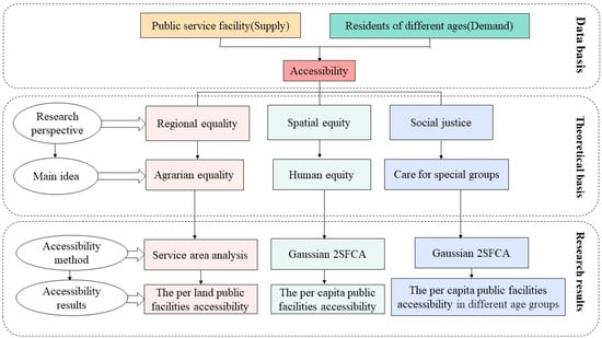
Figure 2.
Research framework based on three perspectives.
2.3.2. Service Area Analysis
Service area analysis determines the service scope of a given spatial object according to its service radius. Based on actual road network conditions, ArcGIS was used to calculate the service area of facilities to obtain the per land public facilities accessibility on average from a regional equality perspective. To determine public facility service radius, this study introduced the “15-min living circle” concept from the Urban Residential Planning and Design Code into accessibility calculations. The reachable area within 15 min at the travel speed of 5 km/h for walking, 15 km/h for non-motor vehicles, and 25 km/h for motor vehicles were taken as the public facility service radius [60,61]. For medical and education facilities, the search threshold was appropriately expanded and the travel time was set to 30 min (as shown in Table 1). Using the service area analysis method in ArcGIS network analysis, the effective service range of various facilities was generated based on actual road network data in Zhengzhou’s urban core in 2020. If there was a partial overlap in service ranges, overlapping parts were repeatedly counted as effective facility service areas. Then, this study superimposed plots that can reach eight public facilities within search thresholds to obtain comprehensive accessibility results for walking, non-motorized, and motor vehicle travel modes. Finally, the integrated accessibility results for all three travel modes were superimposed on one layer. Since the service areas were counted repeatedly when different travel mode service areas overlapped, areas where eight types of public facilities could be reached by walking were the areas with high public facility accessibility, by non-motor vehicles were the areas with general accessibility, and by motor vehicles were the areas with low accessibility.
2.3.3. Gaussian 2SFCA
The two-step floating catchment area (2SFCA) method was first proposed by Radke [62] and further improved by Luo and others [63]. However, the original 2SFCA form lacked distance attenuation form optimization. Wang [64] proposed adding an attenuation function to 2SFCA. Dai [65] introduced a Gaussian attenuation function on this basis and named it Gaussian 2SFCA. Gaussian 2SFCA is an accessibility method that considers both supply and demand perspectives and takes into account supply-side service capacity and demand-side travel willingness with distance attenuation, which can more comprehensively analyze facility accessibility [66,67,68,69].
Based on the above analysis, this study used Gaussian 2SFCA to calculate public facility accessibility in Zhengzhou’s urban core from spatial equity and social justice perspectives. Gaussian 2SFCA implementation is divided into two steps. In the first step, starting from the supplier j (the entrance of public facilities), a spatial search domain is formed according to the set spatial distance threshold d0, and all the demanders i (population) within the search domain are searched. Based on the distance dij between the demander i and the supplier j, the Gaussian attenuation function G(dij) is weighted, and the weighted population is summed to obtain all potential demanders within supply side search domains and then divided by the supply Sj by the number of potential demanders to obtain supply–demand ratio R.
Starting from the demander i (population), another spatial search domain is formed using the set spatial distance threshold d0 in the second step. The supply and demand ratio R of supply-side j in the spatial search domain is weighted using the Gaussian attenuation function. The accessibility Af of each type of supply facility starting from the demand side i is obtained by summing the weighted results. The results represent per capita public facility holdings according to calculation principles. The average accessibility of eight public facilities represents their comprehensive accessibility [37].
This study optimized the supply Sj of public facilities in Zhengzhou’s urban core based on their types, levels, and scales considering the economic and social situation. Medical facilities were divided into first-class hospitals (health centers and clinics), second-class hospitals (general hospitals, specialized hospitals), and third-class hospitals (tertiary hospitals) [70], and the supply Sj was expressed as the number of hospital beds at all levels [71,72]. For hospitals lacking bed data, this paper used Zhengzhou’s 2020 healthcare situation and bed-per-1000-population statistics to supplement the data. Public transport facility supply within/outside the 3rd ring road was weighted considering train differences between bus/subway stations. Educational facility supply was expressed as maximum student capacity using Zhengzhou’s primary/secondary school construction scale standards. Other facilities determined supply capacity based on area and people served.
To calculate public facility accessibility in Zhengzhou’s urban core from a social justice perspective, demand was grouped by age based on 2SFCA juvenile (0–19), youth (20–39), middle-aged (male 39–60, female 39–55), and senior (male 60+, female 55+). In this study, juveniles and seniors, who are more vulnerable to equity and justice issues due to capacity constraints, were regarded as vulnerable groups [73], focusing on the analysis of whether the public facilities allocation in Zhengzhou’s urban core gives special care to them.
3. Results
3.1. The Per Land Public Facilities Accessibility from a Regional Equality Perspective
From a regional equality perspective, per land public facility accessibility showed circular layer characteristics gradually decreasing from inside to outside the 3rd ring road (Figure 3a). In terms of administrative districts (Figure 4a), Jinshui had the highest accessibility area at 33.20 km2, accounting for 36.29% of all high-accessibility areas. Erqi and Zhongyuan followed with 22.13 km2 and 19.50 km2, accounting for 24.19% and 20.82%, respectively. Guancheng was 13.26 km2, accounting for 14.49%. Huiji’s high-accessibility area was only 3.40 km2, accounting for just 3.72% of all high-accessibility areas. The general accessibility area was mainly north of the south 3rd ring road. Jinshui’s general accessibility area accounted for 29.68% (168.35 km2) of all general accessibility areas. Zhongyuan and Guancheng followed closely behind, accounting for 23.51% (133.35 km2) and 20.70% (117.45 km2), respectively. Huiji accounted for 15.29% (86.72 km2). Erqi’s general accessibility was 61.44 km2, accounting for 10.83%. Almost all low accessibility areas were outside the 3rd ring road and more evenly distributed in each district. Jinshui, Zhongyuan, Guancheng, Huiji, and Erqi had low accessibility areas of 210.07 km2 (23.72%), 193.44 km2 (21.85%), 182.32 km2 (20.59%), 152.48 km2 (17.22%), and 147.19 km2 (16.62%), respectively. Comparing the old urban area inside the 3rd ring road and the new urban area outside the 3rd ring road (Figure 4b), the old urban area totaled 203.25 km2 with 38.32% (77.89 km2) high accessibility, mainly near provincial family homes and district governments (Figure 3b), 60.74% (123.45 km2) general accessibility, and 0.94% (1.91 km2) low accessibility. The new urban area outside the 3rd ring road totaled 814.67 km2 with high accessibility (13.60 km2), mainly near Huiji government (Figure 3c), 43.25% (352.37 km2) general accessibility, 38.82% (316.29 km2) low accessibility, and 16.25% (132.42 km2) non-residential areas such as water areas.
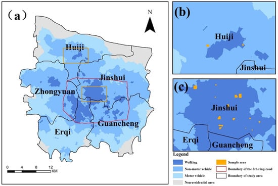
Figure 3.
Per land public facilities accessibility (a), accessibility near Huiji District Government (b), accessibility near family homes and district government (c).
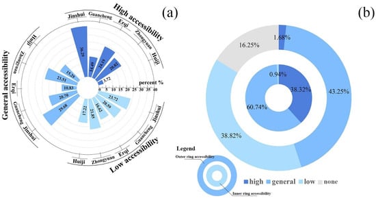
Figure 4.
Accessibility of each administrative region (a) and accessibility inside and outside the 3rd ring road (b) from a regional equality perspective.
In summary, areas with high public facility accessibility were located at the junction of Jinshui, Erqi, and Zhongyuan within Zhengzhou’s urban core’s 3rd ring road (hereinafter referred to as the old urban area). Meanwhile, general accessibility areas expanded outside the 3rd ring road, primarily northward, based on high-accessibility areas. On the other hand, all low accessibility areas were located outside Zhengzhou’s urban core’s 3rd ring road. These results showed that from a regional equality perspective, residents within the 3rd ring road had more public facilities than residents in other regions highlighting inequality in public facility distribution among residents in different regions.
3.2. The Per Capita Public Facilities Accessibility from a Spatial Equity Perspective
From a spatial equity perspective, Figure 5 shows generally consistent accessibility results for walking and non-motor vehicle travel modes with low accessibility within the 3rd ring road and high accessibility outside it. Motor vehicle travel accessibility differed from the first two modes with the highest accessibility within the 3rd ring road gradually decreasing outward. According to each district’s accessibility distribution under three travel modes (Figure 5(a2–c2)), Huiji, Zhongyuan, and Guancheng had more high-accessibility areas for walking and non-motor vehicle travel modes. Under motor vehicle travel mode, each district maintained high accessibility in and around the 3rd ring road with Zhongyuan having slightly higher accessibility than other districts. Based on more residents being inside than outside the 3rd ring road, matching between public facility supply and resident demand within it was poor for walking and non-motor vehicle travel modes resulting in demand exceeding supply. However, motor vehicle travel mode was not subject to limited public facility supply with residents in each district having high public facility accessibility. This indicated that higher-income residents who were able to purchase motor vehicles enjoyed better public facility services than low-income residents.
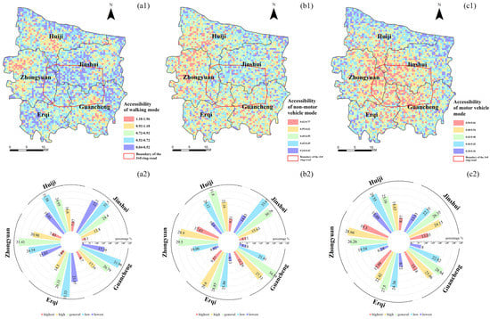
Figure 5.
(a1–c2) Accessibility of three travel modes from a spatial equity perspective.
3.3. The Public Facilities Accessibility from a Social Justice Perspective
Public facility accessibility results for different age groups in Zhengzhou’s urban core under walking mode were the highest and high-accessibility areas were distributed outside the 3rd ring road. Within the 3rd ring road, except for some Guancheng areas, accessibility was good, and in most other areas accessibility was poor (Figure 6(a1–a4)). From an age group perspective (Figure 6b), youth aged 20–39 had better accessibility than other age groups. The lowest accessibility level was for senior residents aged over 60 for men and over 55 for women. Accessibility results for juveniles aged 0–19 and middle-aged people aged 40–55/60 were at a general level. From different age group perspectives within the same administrative region (Figure 7a), Jinshui’s senior residents had better public facility accessibility than other age groups in this region. Youth residents had the best public facility accessibility in other administrative regions. The lowest accessibility age group in Huiji and Guancheng was juveniles, while in Erqi and Zhongyuan it was seniors. From different administrative region perspectives within the same age group (Figure 7b), Huiji had the highest public facility accessibility for all age groups while Jinshui had the lowest. Additionally, youth, middle-aged, and senior resident accessibility in Zhongyuan and Guancheng was good, and juvenile resident accessibility was also good in Zhongyuan.
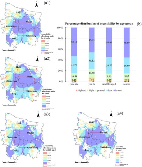
Figure 6.
(a1–a4,b) Accessibility for different age groups under walking mode from a social justice perspective.
Figure 7.
Accessibility percent distribution from different age groups within the same administrative region (a), and from different administrative regions within the same age group (b) under walking mode from a social justice perspective.
Under non-motor vehicle mode, public facility accessibility results for different age groups in Zhengzhou’s urban core improved from walking mode. However, overall accessibility within the 3rd ring road remained lower than outside it (Figure 8(a1–a4)). From an age group perspective (Figure 8b), youth still had the highest public facility accessibility, followed by juveniles and seniors, with middle-aged residents having the lowest accessibility results. From different age group perspectives within the same administrative region (Figure 9a), similar to walking mode results, Jinshui’s senior residents had this region’s highest public facility accessibility with youth residents enjoying the highest accessibility in other administrative regions. The lowest accessibility age group in Guancheng was middle-aged residents while in Erqi and Zhongyuan it was seniors. All age groups in Huiji had relatively average accessibility. From different administrative region perspectives within the same age group (Figure 9b), juvenile and youth residents had the highest public facility accessibility in Zhongyuan and the lowest in Jinshui. Middle-aged and senior residents had the highest accessibility in Huiji and the lowest in Erqi.
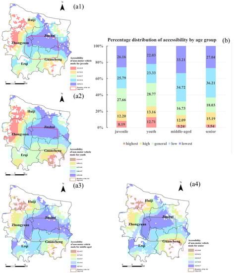
Figure 8.
(a1–a4,b) Accessibility for different age groups under non-motor vehicle mode from a social justice perspective.
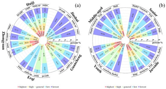
Figure 9.
Accessibility percent distribution from different age groups within the same administrative region (a) and from different administrative regions within the same age group (b) under non-motor vehicle mode from a social justice perspective.
Under motor vehicle mode, public facility accessibility for different age groups in Zhengzhou’s urban core was completely different. Motor vehicle driving greatly improved accessibility in most of Zhengzhou’s urban core except in the northeast direction (Figure 10(a1–a4)). From an age group perspective (Figure 10b), youth residents still had the highest accessibility compared to other age groups but with a reduced difference in degree. The accessibility of other age groups was relatively average. From different age group perspectives within the same administrative region (Figure 11a), senior residents in Jinshui and Guancheng, youth residents in Erqi and Zhongyuan, and middle-aged residents in Huiji had the highest accessibility. Conversely, youth residents in Jinshui and Huiji, juvenile residents in Guancheng, and senior residents in Erqi and Zhongyuan had the lowest accessibility levels. From different administrative region perspectives within the same age group (Figure 11b), juvenile, youth, and middle-aged residents had the highest public facility accessibility in Zhongyuan and the lowest in Jinshui. Senior residents had the highest accessibility in Guancheng and the lowest in Huiji.
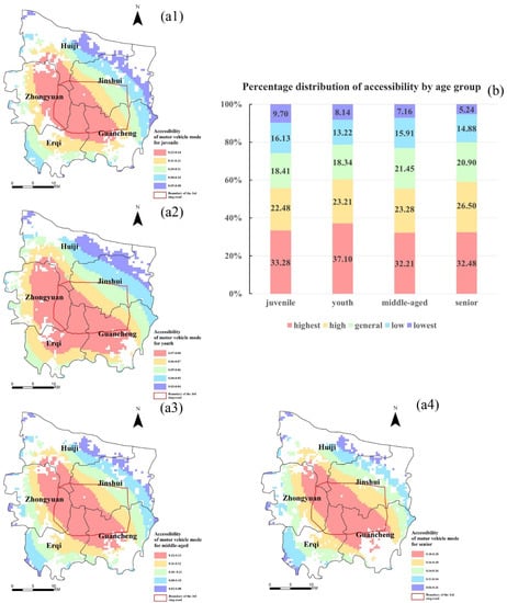
Figure 10.
(a1–a4,b) Accessibility for different age groups under motor vehicle mode from a social justice perspective.
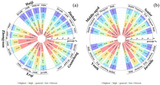
Figure 11.
Accessibility percent distribution from different age groups within the same administrative region (a) and from different administrative regions within the same age group (b) under motor vehicle mode from a social justice perspective.
Summarizing public facility accessibility results in Zhengzhou’s urban core under different travel modes showed that youth residents aged 20–39 had the highest accessibility regardless of travel mode. Although Jinshui’s senior residents enjoyed better public facilities than seniors in other administrative regions, their accessibility level was still far lower than youth residents. These results implied that Zhengzhou’s main urban area’s public facility allocation lacked preferential treatment for the vulnerable groups of juveniles and seniors with social justice being more prominent.
4. Discussion
Various factors influence the issue of equity and justice in public facilities. Scholars have analyzed its causes from public policy [74,75,76], economic development [77], urbanization [78], population perspectives [47,79], etc. Based on an analysis of public facility distribution in Zhengzhou’s urban core regarding regional equality, spatial equity, and social justice, this paper found prominent equity and justice problems. Combined with Zhengzhou’s urbanization history, equity and justice issues in public facilities were closely related to planning heritage, supply subject diversification, and housing marketization.
4.1. The Planning Heritage of Urban–Rural Dual Public Facilities System in the Planned Economy Period
In 1956, the completion of the Three Great Remoldings established China’s socialist system. A highly centralized/unified planned economy was implemented with the government as the only public facility supplier. During the planned economy period, most urban residents worked in state agencies/government-affiliated institutions and enjoyed welfare housing distribution and unit-provided medical care, old-age care, and children’s education infrastructure [80]. “Unit compound” living units formed within cities. In rural areas, welfare policy was based on a collective economy (e.g., collectively funded education/cooperative medical care) with a lack of physical public facilities. Old urban areas completed during the planned economy period have more public facility planning heritage than rural/undeveloped areas outside the 3rd ring road. The planning heritage from the planned economy’s urban–rural dual public facility system explains why old urban area accessibility is higher than outside-3rd-ring-road accessibility from a regional equality perspective [3,74]. Since the Reform and Opening Up, Zhengzhou has attracted many foreign laborers (migrant workers) without city housing who gather in old urban areas and dilapidated rental communities [81,82,83,84]. The government relies too much on planned economy period public facility planning heritage and rarely provides the necessary supply for new demand, pressuring old urban area public facility supply. From a spatial equity perspective, accessibility within the 3rd ring road is low, while outside-3rd-ring-road accessibility is high.
4.2. Diversification of Public Facilities Supply Subject to a Transition Period
Since the Reform and Opening Up, national governance has focused on economic development. China has undergone major changes in economy, social structure, and social governance. The greatest impact on public facility equity is supply subject diversification due to government decentralization reform and public service marketization. Decentralization reform made local governments independent interest subjects with jurisdictional public resource disposal rights but also brought more rent-seeking opportunities. Local governments’ dual pursuit of self-interest and public interest representation affects public service quality [85]. To develop economies/enhance city competitiveness, local governments prefer investing in profitable rather than welfare facilities, causing governmental absence in public facility supply. During the transition from a planned to a market economy, various enterprises/non-profit organizations entered the public facility supply market promoting public service marketization, and supply subjects diversified into government/enterprise/non-profit organizations [86]. Market competition/comparative advantage-driven interest positioning causes differentiated risks in facility supply with governmental absence increasing risk prominence. Barbosa [75] pointed out that government public policies play a decisive role in public facility accessibility distribution for social groups, especially vulnerable ones. Panter’s UK sports facility equity study indicated that public facility supply marketization might neglect vulnerable groups [87]. The Reform and Opening Up increased new demand for old urban area public facilities and urged new supply due to the rapid expansion of newly developed areas outside the 3rd ring road. To maximize interests, multiple public facility supply subjects during transition prioritize residents with strong payment ability (mostly youth/middle-aged needing to buy houses) over those with weak payment ability (juveniles without housing purchase ability/seniors who solved housing problems during the planned economy) when providing facilities for newly developed land [88]. As a result, vulnerable group public facility accessibility is low from a social justice perspective.
4.3. The Cost of Housing Marketization Reform
Housing marketization reform impacts public facility equity. China began market-oriented housing reform in the late 1970s [89]. Welfare housing property rights were transferred from the work department to workers. Most welfare housing was in old urban areas. Residents sold or rented it to buy new housing with better facilities [90]. A Nanjing study found that 80% of residents in areas with high-quality education facilities were white-collar workers [91]. Meng argued that housing marketization reform widened the income gap between social groups, causing residential and social differentiation. Wu [92] stated that housing was a certificate of rights to use public facilities or services, and promoting the equalization of public services and the regional balance of public facilities input was necessary to reduce residential segregation between classes.
On the other hand, housing marketization reform commercializes new housing, encouraging foreign capital and real estate enterprises to develop commercial housing and shifting supply from state to market. With diversified public facility suppliers and the 1993 tax reform, local governments bear local public goods expenditure responsibility. To reduce financial pressure, the government avoids building public facilities by repeatedly dividing land many times [93]. Therefore, unsynchronized housing and public facility construction led to a growing contradiction between supply and demand [94,95]. Housing-related elements in real estate have been commercialized. Public facilities like transportation, parks, and hospitals have been capitalized into housing prices [96], worsening the inequality of different income groups in obtaining public facilities.
4.4. The Influence of Chinese Traditional Culture and Family Values
Residents’ limitations also influence public facility accessibility. Chinese society values familial relationships and families often have consistent residential intentions. With a well-developed public transportation network, Chinese residents tend to rely on public transportation and prefer to live in communities with fully equipped facilities. Unlike US suburbs, where attractiveness promotes active relocation, China’s urban transformation mostly originates from passive evacuation due to central urban area overcrowding [97]. This makes forming strong sub-center population clusters difficult, resulting in high city-center population concentration and pressure on public facility supply.
Moreover, downtown old towns have more schools with long histories and good teaching quality. Under China’s compulsory education school district system, parents value school districts due to the “Wang Zi Cheng long” (look forward to the success of one’s children) philosophy and gather near “good schools” [98]. Even with the availability of larger and newer educational facilities in newly developed areas, Chinese parents often prefer to remain in the city center. This reluctance to relocate is one of the main reasons why many Chinese people choose not to move away from urban areas.
4.5. Proposal
To alleviate the equity and justice issues caused by the unreasonable allocation of public facilities in Zhengzhou’s urban core, the government can set up targeted decision-making goals and take corresponding measures according to the actual situation of different regions based on this paper’s three-perspective accessibility results. When the government’s decision-making goal is to pursue regional equality and achieve spatial equity as much as possible, combined with regional urbanization development and the population aggregation degree, the government can evacuate the crowd as the focus of the old urban area to ease the pressure of public facility supply. Using a teacher rotation system, a small class teaching community and big data information technology can improve the coverage of quality education resources. This can help parents escape school district housing dilemmas and actively relocate. In new urban areas, it is necessary to take market research before planning and constructing new public facilities, improve the utilization rate of existing public facilities, and avoid vacant resource waste. At the same time, attention should be paid to gentrification to avoid well-intentioned actions having negative consequences. When the government’s decision-making goal is to pursue the social justice of public facilities, the government should start with the public facility supply and provide more public facilities services to areas with a large proportion of juveniles and seniors, especially education, medical care, leisure, and entertainment facilities.
Additionally, the Chinese government should focus more on equity and justice in public facilities by promoting reform and exploring supply models better suited to China’s actual situation [99]. While introducing market mechanisms to improve supply efficiency, it is important to establish market supervision and government monitoring mechanisms to prevent the public facilities supply market from becoming a profit-seeking tool for capital. The government and enterprises should be properly separated with the strengthened supervision of government–enterprise cooperation projects to prevent rent-seeking behavior by officials. Public participation in the planning process should be increased to ensure that public facilities serve the public interest. The household registration system reform should be deepened and the government urged to provide necessary basic facilities to actual residents [100,101].
4.6. Innovation and Research Deficiencies
This paper used time cost instead of traditional distance cost for public facility search thresholds, considering that residents’ travel psychology prioritized time over distance [65,102]. Moreover, a graded threshold was used for special public facilities such as medical, and the calculation results were more in line with the actual situation. In terms of research perspectives, this study calculated comprehensive public facility accessibility from regional equality, spatial equity, and social justice perspectives. The research obtained accessibility per land, per capita, and per capita by age group, and a multi-dimensional analysis more comprehensively revealed the equity and justice of public facilities. This research can provide decision-making suggestions for the location planning of public service facilities in cities with similar development potential to Zhengzhou and a high cost of investment and construction and enhance the living happiness of residents. In addition, the idea of equity and justice discussed in this paper has also been applied in the urban planning and management field [103], which can be extended to other fields in the future.
In this paper, the supply of educational facilities was defined by the number of students in the school, resulting in relatively rough estimates. Some scholars [104,105] used data on teaching quality and supporting hardware to assign weights to the supply of educational facilities. This approach was not adopted in this study due to the limitations of educational facilities’ data sources in the study area. Future research could explore more refined methods for forecasting the supply of educational facilities.
5. Conclusions
Understanding and analyzing the inequality of urban public facilities is an important step for optimizing public resource allocation and achieving sustainable urbanization. This study constructed a multi-dimensional analysis system for public facility equity and justice and calculated and analyzed the current situation and causes of public facility equity and justice in Zhengzhou’s urban core area in conjunction with the urbanization development process. The results showed that from a regional equality perspective, influenced by public facility planning heritage from the planned economy period, public facility per land equality within Zhengzhou’s urban core’s old urban area inside the 3rd ring road was good with no significant accessibility differences. However, there were great differences between areas inside and outside the 3rd ring road. Public facility per land accessibility within the 3rd ring road was significantly higher than outside. Public facility per land equality was worse in areas outside the 3rd ring road. From a spatial equity perspective, there was insufficient equity in public facilities per capita. Although public facility planning heritage led to a large number of public facilities within the 3rd ring road, there was poor matching between public facility supply and resident demand. This resulted in some areas outside the 3rd ring road having better per capita accessibility while those inside the 3rd ring road had lower per capita accessibility. From a social justice perspective, Zhengzhou’s urban core’s public facility planning under housing marketization did not provide much preferential care to the vulnerable juveniles and seniors with youth residents enjoying better public facility services. Multiple public facility suppliers pursued their own interests with social justice needing improvement in Zhengzhou’s urban core’s public facilities. Overall, during Zhengzhou’s rapid urbanization, social equity and justice were ignored due to government public policy influence with much room for improvement in existing public facility planning and layout. The Zhengzhou government should combine regional equality, spatial equity, and social justice to serve the public interest by establishing a supervisory feedback mechanism for public management work. Rather than relying on public facility planning heritage, appropriate use should be made while actively cultivating high-quality suppliers to improve facility quality and supply efficiency by diversifying supply. This can positively address equity and justice issues during urbanization.
Author Contributions
Conceptualization, M.C. and T.Z.; methodology, M.C. and L.H.; software, M.C. and Y.M.; validation, M.C. and Y.M.; formal analysis, T.Z. and Y.M.; investigation, M.C.; resources, T.Z. and L.H.; data curation, J.Z.; writing—original draft preparation, M.C. and T.Z.; writing—review and editing, M.C., T.Z., L.H. and C.Z.; visualization, L.H.; supervision, T.Z. and L.H.; project administration, T.Z. and L.L.; funding acquisition, T.Z. All authors have read and agreed to the published version of the manuscript.
Funding
This research was funded by the National Natural Science Foundation of China (Grant No. 42101298), Key R&D and Promotion Special Project (Science and Technology) of Henan Province, China (Grant No. 232102320195), and the special fund for young talents of Henan Agricultural University (Grant No. 30500956).
Data Availability Statement
Not applicable.
Conflicts of Interest
The authors declare no conflict of interest.
References
- Wei, Y.D.; Ewing, R. Urban expansion, sprawl and inequality. Landsc. Urban Plan. 2018, 177, 259–265. [Google Scholar] [CrossRef]
- Yang, S.; Gu, G. Evaluation of Urban Public Service Facilities Carrying Capacity Based on Delphi-AHP and Grey Relational Analysis. Math. Pract. Theory 2018, 48, 311–320. [Google Scholar]
- Xiao, Y.; Wang, Z.; Li, Z.; Tang, Z. An assessment of urban park access in Shanghai-Implications for the social equity in urban China. Landsc. Urban Plan. 2017, 157, 383–393. [Google Scholar] [CrossRef]
- Ye, C. The methodology on spatial justice and new-type urbanization. Geogr. Res. 2019, 38, 146–154. [Google Scholar]
- China’s Moderately Prosperous Society in All Respects. Available online: http://www.stats.gov.cn/xxgk/jd/zcjd/202109/t20210930_1822661.html (accessed on 28 September 2021).
- Zhang, Y.; Wang, M.; Zhang, D.; Lu, Z.; Bakhshipour, A.E.; Liu, M.; Jiang, Z.; Li, J.; Tan, S.K. Multi-stage planning of LID-GREI urban drainage systems in response to land-use changes. Sci. Total Environ. 2023, 859, 160214. [Google Scholar] [CrossRef]
- Zheng, Q.; Zhao, X.; Jin, M. Research on Urban Public Green Space Planning based on TAXI DATA: A case study on three districts of Shenzhen, China. Sustainability 2019, 11, 1132. [Google Scholar] [CrossRef]
- Shi, X.; Qin, M.; Li, B.; Zhang, D. A framework for optimizing green infrastructure networks based on landscape connectivity and Ecosystem Services. Sustainability 2021, 13, 10053. [Google Scholar] [CrossRef]
- Xu, H.; Yan, Y. Integrated Planning Model of land-use layout and transportation network design for regional urbanization in China based on Tod Theory. J. Urban Plan. Dev. 2021, 147, 04021013. [Google Scholar] [CrossRef]
- Vu, S.; Jain, A.; Harrison, C.; Ghimire, P.; Graham, J.P. “Someone should be there to take care of it”: A case study of users’ views of managed shared sanitation facilities in Jharkhand, India. Am. J. Trop. Med. Hyg. 2022, 106, 1135–1140. [Google Scholar] [CrossRef]
- Yang, Y.; Ng, S.T.; Xu, F.J.; Skitmore, M. Towards sustainable and resilient high-density cities through better integration of Infrastructure Networks. Sustain. Cities Soc. 2018, 42, 407–422. [Google Scholar] [CrossRef]
- Cumming, T.L.; Shackleton, R.T.; Förster, J.; Dini, J.; Khan, A.; Gumula, M.; Kubiszewski, I. Achieving the National Development Agenda and the sustainable development goals (SDGs) through investment in ecological infrastructure: A case study of south Africa. Ecosyst. Serv. 2017, 27, 253–260. [Google Scholar] [CrossRef]
- Xu, Z.; Niu, L.; Zhang, Z.; Huang, J.; Lu, Z.; Huang, Y.; Wen, Y.; Li, C.; Gu, X. Sustainable development of life service resources: A new framework based on GIScience and Spatial Justice. Remote Sens. 2022, 14, 2031. [Google Scholar] [CrossRef]
- Hakimi, S.L. Optimum Locations of Switching Centers and the Absolute Centers and Medians of a Graph. Oper. Res. 1964, 12, 450–459. [Google Scholar] [CrossRef]
- Hakimi, S.L. Optimum Distribution of Switching Centers in a Communication Network and Some Related Graph Theoretic Problems. Oper. Res. 1965, 13, 462–475. [Google Scholar] [CrossRef]
- Church, R.L.; Revelle, C.S. Theoretical and Computational Links between the p-Median, Location Set-covering, and the Maximal Covering Location Problem. Geogr. Anal. 1976, 8, 406–415. [Google Scholar] [CrossRef]
- Mumphrey, A.J.; Seley, J.E.; Wolpert, J. A decision model for locating controversial facilities. J. Am. Inst. Plan. 1971, 37, 397–402. [Google Scholar] [CrossRef]
- Mcallister, D.M. Equity and efficiency in public facility location. Geogr. Anal. 1976, 8, 47–63. [Google Scholar] [CrossRef]
- Savas, E.S. On equity in providing public services. Manag. Sci. 1978, 46, 144–148. [Google Scholar] [CrossRef]
- Kenzheguzin, M.B.; Yessekina, B.K. Methodological basis of forecasting of sustainable development of Economic System. Math. Comput. Simul. 2004, 67, 343–349. [Google Scholar] [CrossRef]
- Joseph, A.E.; Bantock, P.R. Measuring potential physical accessibility to general practitioners in rural areas: A method and case study. Soc. Sci. Med. 1982, 16, 85–90. [Google Scholar] [CrossRef]
- Talen, E.; Anselin, L. Assessing spatial equity: An evaluation of measures of accessibility to public playgrounds. Environ. Plan. A 1998, 30, 595–613. [Google Scholar] [CrossRef]
- Yu, S.; Zhu, X.; He, Q. An assessment of urban park access using house-level data in urban China: Through the lens of Social Equity. Int. J. Environ. Res. Public Health 2020, 17, 2349. [Google Scholar] [CrossRef] [PubMed]
- Lan, T.; Liu, Y.; Huang, G.; Corcoran, J.; Peng, J. Urban green space and cooling services: Opposing changes of Integrated Accessibility and social equity along with urbanization. Sustain. Cities Soc. 2022, 84, 104005. [Google Scholar] [CrossRef]
- Jin, M.; Liu, L.; Tong, D.; Gong, Y.; Liu, Y. Evaluating the spatial accessibility and distribution balance of Multi-Level Medical Service Facilities. Int. J. Environ. Res. Public Health 2019, 16, 1150. [Google Scholar] [CrossRef]
- Shi, T.; Li, J.; Li, Y.; Yin, H. Analysis of urban park accessibility in Shenyang City. Chin. J. Ecol. 2016, 35, 1345–1350. [Google Scholar] [CrossRef]
- Moyano, A.; Martinez, H.S.; Coronado, J.M. From network to services: A comparative accessibility analysis of the Spanish high-speed rail system. Transp. Policy 2018, 63, 51–60. [Google Scholar] [CrossRef]
- Chen, Y.; Huang, Q.; Zhang, Y.; Li, Y. GIS-based analysis and evaluation for the accessibility of urban green in the central city of Hefei. J. China Agric. Univ. 2015, 20, 229–236. [Google Scholar]
- Tong, D.; Sun, Y.; Xie, M. Evaluation of green space accessibility based on improved Gaussian two-step floating catchment area method: A case study of Shenzhen City, China. Prog. Geogr. 2021, 40, 1113–1126. [Google Scholar] [CrossRef]
- Tahmasbi, B.; Mansourianfar, M.H.; Haghshenas, H.; Kim, I. Multimodal Accessibility-based equity assessment of Urban Public Facilities Distribution. Sustain. Cities Soc. 2019, 49, 101633. [Google Scholar] [CrossRef]
- Huang, B.; Chiou, S.; Li, W. Accessibility and street network characteristics of Urban Public Facility Spaces: Equity Research on Parks in Fuzhou city based on GIS and space syntax model. Sustainability 2020, 12, 3618. [Google Scholar] [CrossRef]
- Ma, F. Spatial equity analysis of urban green space based on Spatial Design Network Analysis (sDNA): A case study of central Jinan, China. Sustain. Cities Soc. 2020, 60, 102256. [Google Scholar] [CrossRef]
- Cheng, T.; Liu, C.; Yang, H.; Wang, N.; Liu, Y. From service capacity to spatial equity: Exploring a multi-stage decision-making approach for optimizing elderly-care facility distribution in the city centre of Tianjin, China. Sustain. Cities Soc. 2022, 85, 104076. [Google Scholar] [CrossRef]
- Gao, J.; Zhou, C.; Jiang, H.; Ye, C. The Research on The Spatial Differentiation of The Urban Public Service Facilities Distribution in Guangzhou. Hum. Geogr. 2010, 25, 78–83. [Google Scholar] [CrossRef]
- Luo, R.; Liu, Y.; Zong, J. A Study on the Residential Spatial Differentiation and Differences of Access to Public Service Facilities in Chengdu. J. Southwest Jiaotong Univ. (Soc. Sci.) 2018, 19, 68–77. [Google Scholar] [CrossRef]
- Wang, M.; Zhu, A.; Wang, J.; Lu, T. Supply and demand analysis of urban park distribution based on social equity and justice: A case study of Xuhui District, Shanghai. Acta Ecol. Sin. 2019, 39, 7035–7046. [Google Scholar] [CrossRef]
- Wang, J.; Zhu, W.; Liu, T. Spatial Accessibility, Social Capital and Mental Wellbeing of Urban Residents: A Case Study of Beijing. Hum. Geogr. 2022, 37, 18–27. [Google Scholar] [CrossRef]
- Liu, M.; Luo, S.; Du, X. Exploring equity in healthcare services: Spatial accessibility changes during subway expansion. Int. J. Geo-Inf. 2021, 10, 439. [Google Scholar] [CrossRef]
- Jiang, H.; Zhang, W.; Wei, S. Public service facility accessibility as influenced by public transportation in Beijing. Prog. Geogr. 2017, 36, 1239–1249. [Google Scholar] [CrossRef][Green Version]
- Liu, S.; Yang, G.; Wu, Z.; Mao, F.; Chang, J. Studying the distribution patterns, dynamics and influencing factors of city functional components by gradient analysis. Sci. Rep. 2021, 11, 17802. [Google Scholar] [CrossRef]
- Chen, Q. A Study on the Urbanization Process of Central Plains Economic Zone—Taking the Urbanization Process of Zhengzhou City as An Example. Henan Soc. Sci. 2012, 20, 104–106. [Google Scholar] [CrossRef]
- Xie, Y.; Thornton, A.; Wang, G.; Lai, Q. Societal projection: Beliefs concerning the relationship between development and inequality in China. Soc. Sci. Res. 2012, 41, 1069–1084. [Google Scholar] [CrossRef] [PubMed]
- Wolch, J.R.; Byrne, J.; Newell, J.P. Urban green space, public health, and environmental justice: The challenge of making cities ‘just green enough’. Landsc. Urban Plan. 2014, 125, 234–244. [Google Scholar] [CrossRef]
- Zhao, Y.; Zhang, G.; Lin, T.; Liu, X.; Liu, J.; Lin, M.; Ye, H.; Kong, L. Towards Sustainable Urban Communities: A Composite Spatial Accessibility Assessment for Residential Suitability Based on Network Big Data. Sustainability 2018, 10, 4767. [Google Scholar] [CrossRef]
- Zhan, D.; Zhang, W.; Chen, L.; Yu, X.; Dang, Y. Research progress and its enlightenment of urban public service facilities allocation. Progress in Geography. Prog. Geogr. 2019, 38, 506–519. [Google Scholar] [CrossRef]
- Ottensmann, J.R. Evaluating Equity in Service Delivery in Library Branches. J. Urban Aff. 1994, 16, 109–123. [Google Scholar] [CrossRef]
- Feng, S.; Chen, L.; Sun, R.; Feng, Z.; Li, J.; Khan, M.S.; Jing, Y. The Distribution and Accessibility of Urban Parks in Beijing, China: Implications of Social Equity. Int. J. Environ. Res. Public Health 2019, 16, 4894. [Google Scholar] [CrossRef] [PubMed]
- Smith, D.M. Geography and Social Justice. J. Econ. Issues 1994, 17, 335–344. [Google Scholar] [CrossRef]
- Trinder, E.; Hay, A.; Dignan, J.; Else, P.; Skorupski, J. Concepts of equity, fairness, and justice in British transport legislation, 1960–1988. Environ. Plan. C Gov. Policy 1991, 9, 31–50. [Google Scholar] [CrossRef]
- William, L. Equity and Planning for Local Services. J. Am. Plan. Assoc. 1981, 47, 447–457. [Google Scholar] [CrossRef]
- Jiang, H.; Zhou, C.; Gao, J. Advance in The Equity of Spatial Distribution of Urban Public Service in Western Countries. City Plan. Rev. 2011, 35, 72–77. [Google Scholar]
- Tang, Z.; Gu, S. An Evaluation of Social Performance in the Distribution of Urban Parks in the Central City of Shanghai: From Spatial Equity to Social Equity. Urban Plan. Forum 2015, 222, 48–56. [Google Scholar] [CrossRef]
- Tang, Z.; Gu, S. An Evaluation of Social Performance in the Distribution of Urban Parks in the Central City of Shanghai: From Social Equity to Social Justice. Urban Plan. Forum 2016, 227, 15–21. [Google Scholar] [CrossRef]
- Shen, Q.; Zhang, Y.; Zhang, F. Location Characteristics of Inner-city Neighborhoods and Employment Accessibility of Low-wage Workers. Urban Plan. Int. 2007, 22, 26–35. [Google Scholar] [CrossRef]
- Hu, R.; Dong, S.; Hu, H. A two-step Floating Catchment Area (2SFCA) Method for Measuring Spatial Accessibility to Primary Healthcare Service in China: A Case Study of Donghai County in Jiangsu Province. Prog. Geogr. 2012, 31, 1600–1607. [Google Scholar] [CrossRef]
- Sang, L.; Shu, Y.; Zhu, W.; Su, F. Accessibility of urban green spaces in Hangzhou City. Prog. Geogr. 2013, 32, 950–957. [Google Scholar] [CrossRef]
- Song, W.; Tu, T.; Yin, S.; Xu, Y.; Liu, C. The differentiation and effects of social-spatial accessibility in compulsory education resources in Nanjing. Geogr. Res. 2019, 38, 2008–2026. [Google Scholar] [CrossRef]
- Wang, F.; Onega, T. Accessibility of cancer care: Disparities, outcomes and mitigation. Ann. GIS 2015, 21, 119–125. [Google Scholar] [CrossRef]
- Yu, K.; Duan, T.; Li, D.; Peng, J. Landscape Accessibility as a Measurement of the Function of Urban Green System. City Plan. Rev. 1999, 23, 5. [Google Scholar]
- Xiao, H.; Yuan, Q.; Xu, H. Green Space Distribution Based on Accessibility and Serving Area. Planners 2009, 25, 83–88. [Google Scholar] [CrossRef]
- Xiao, T.; Ding, T.; Zhang, X.; Tao, Z.; Liu, Y. Spatial Accessibility to Sports Facilities in Dongguan, China: A Multi-Preference Gaussian Two-Step Floating Catchment Area Method. Appl. Spat. Anal. Policy 2022, 15, 1093–1114. [Google Scholar] [CrossRef]
- Radke, J.; Mu, L. Spatial Decompositions, Modeling and Mapping Service Regions to Predict Access to Social Programs. Ann. GIS 2000, 6, 105–112. [Google Scholar] [CrossRef]
- Luo, W.; Wang, F. Measures of Spatial Accessibility to Health Care in a GIS Environment: Synthesis and a Case Study in the Chicago Region. Environ. Plan. B Plan. Des. 2003, 30, 865–884. [Google Scholar] [CrossRef] [PubMed]
- Wang, F. Measurement, Optimization, and Impact of Health Care Accessibility: A Methodological Review. Ann. Assoc. Am. Geogr. 2012, 102, 1104–1112. [Google Scholar] [CrossRef] [PubMed]
- Dai, D. Racial/ethnic and socioeconomic disparities in urban green space accessibility: Where to intervene? Landsc. Urban Plan. 2011, 102, 234–244. [Google Scholar] [CrossRef]
- Dai, D. Black residential segregation, disparities in spatial access to health care facilities, and late-stage breast cancer diagnosis in metropolitan Detroit. Health Place 2010, 16, 1038–1052. [Google Scholar] [CrossRef] [PubMed]
- Dai, D.; Wang, F. Geographic disparities in accessibility to food stores in southwest Mississippi. Environ. Plan. B Plan. Des. 2011, 38, 659–677. [Google Scholar] [CrossRef]
- Dan, W.; Xiao, Y.; Hu, Z.; Zhan, Q. Rural Emergency Shelter Accessibility Using Gaussian Based 2-step Floating Catchment Area Method. J. Geo-Inf. Sci. 2018, 20, 10. [Google Scholar] [CrossRef]
- Tian, M.; Yuan, L.; Guo, R.; Wu, Y.; Liu, X. Sustainable Development: Investigating the Correlations between Park Equality and Mortality by Multilevel Model in Shenzhen, China. Sustain. Cities Soc. 2021, 75, 103385. [Google Scholar] [CrossRef]
- Zhang, D.; Zhang, G.; Zhou, C. Differences in accessibility of public health facilities in hierarchical municipalities and the spatial pattern characteristics of their services in Doumen district, China. Land 2021, 10, 1249. [Google Scholar] [CrossRef]
- Fu, L.; Wang, Y.; Zeng, B.; Mao, Y.; Gao, M. Spatial Accessibility of Medical Facilities in Beibei District based on Modified Two-step Floating Catchment Area Method. J. Geo-Inf. Sci. 2019, 21, 1565–1575. [Google Scholar] [CrossRef]
- Guo, C. Accessibility analysis of medical facilities based on multiple transportation modes of network map. J. Geo-Inf. Sci. 2022, 24, 483–494. [Google Scholar] [CrossRef]
- Reyes, M.; Páez, A.; Morency, C. Walking accessibility to urban parks by children: A case study of Montreal. Landsc. Urban Plan. 2014, 125, 38–47. [Google Scholar] [CrossRef]
- Xie, B.; Peng, J.; Luo, X. Even Public Service Development with Social Security System Reform: Western Experience. Planners 2014, 30, 11–16. [Google Scholar] [CrossRef]
- Barbosa, O.; Tratalos, J.A.; Armsworth, P.R.; Davies, R.G.; Fuller, R.A.; Johnson, P.; Gaston, K.J. Who benefits from access to green space? A case study from Sheffield, UK. Landsc. Urban Plan. 2007, 83, 187–195. [Google Scholar] [CrossRef]
- Liu, L. China’s dusty lung crisis: Rural-urban health inequity as social and spatial injustice. Soc. Sci. Med. 2019, 233, 218–228. [Google Scholar] [CrossRef] [PubMed]
- Xu, R.; Yue, W.; Wei, F.; Yang, G.; Chen, Y.; Pan, K. Inequality of public facilities between urban and rural areas and its driving factors in ten cities of China. Sci. Rep. 2022, 12, 13244. [Google Scholar] [CrossRef]
- Pandey, B.; Brelsford, C.; Seto, K.C. Infrastructure inequality is a characteristic of urbanization. Proc. Natl. Acad. Sci. USA 2022, 119, e2119890119. [Google Scholar] [CrossRef]
- Zheng, W.; Jiang, H.; Ai, H.; Luo, J.; Wang, X. Analysis of regional inequalities of basic medical resources supply in China. Geogr. Res. 2015, 34, 2049–2060. [Google Scholar]
- Chai, Y. Danwei-based Chinese Cities’ Internal Life-space Structure—A Case Study of Lanzhou City. Geogr. Res. 1996, 15, 30–38. [Google Scholar] [CrossRef]
- Li, Z.; Wu, F. Tenure-based residential segregation in post-reform Chinese cities: A case study of Shanghai. Trans. Inst. Br. Geogr. 2008, 33, 404–419. [Google Scholar] [CrossRef]
- Liao, B.; Wong, D.W. Changing urban residential patterns of Chinese migrants: Shanghai, 2000–2010. Urban Geogr. 2015, 36, 109–126. [Google Scholar] [CrossRef]
- Ma, S.; Li, Q.; Zhou, X.; Cao, W.; Jiang, M.; Li, L. Assessment of health inequality between urban-to-urban and rural-to-urban migrant older adults in China: A cross-sectional study. BMC Public Health 2020, 20, 268. [Google Scholar] [CrossRef] [PubMed]
- Guo, Y.; Qiao, W. Rural migration and urbanization in China: Historical evolution and coupling pattern. Sustainability 2020, 12, 7307. [Google Scholar] [CrossRef]
- Diaz-Serrano, L.; Meix-Llop, E. Decentralization and the quality of public services: Cross-country evidence from educational data. Environ. Plan. C Politics Space 2019, 37, 1296–1316. [Google Scholar] [CrossRef]
- Zhou, C.; Gao, J. Provision Pattern of Urban Public Service Facilities and its Formation Mechanism During Transitional China. Sci. Geogr. Sin. 2011, 31, 272–279. [Google Scholar] [CrossRef]
- Panter, J.; Jones, A.; Hillsdon, M. Equity of access to physical activity facilities in an English city. Prev. Med. 2008, 46, 303–307. [Google Scholar] [CrossRef] [PubMed]
- Wang, Q. Health of the Elderly Migration Population in China: Benefit from Individual and Local Socioeconomic Status? Int. J. Environ. Res. Public Health 2017, 14, 370. [Google Scholar] [CrossRef] [PubMed]
- Zhao, Y.; Bourassa, S.C. China’s urban housing reform: Recent achievements and new inequities. Hous. Stud. 2003, 18, 721–744. [Google Scholar] [CrossRef]
- Zheng, S.; Fu, Y.; Liu, H. An Empirical Study on the Willingness to Pay for Residential Location and Location Choice of Urban Residents in China. Econ. Geogr. 2005, 25, 194–198. [Google Scholar] [CrossRef]
- Wu, Q.; Zhang, X.; Waley, P. Jiaoyufication: When gentrification goes to school in the Chinese inner city. Urban Stud. 2016, 53, 3510–3526. [Google Scholar] [CrossRef]
- Wu, K.; Fan, X. Residential Space, Assets Carrier and Document of Title: Research on the Triple Functions of Housing. Acad. Bimest. 2021, 127–134. [Google Scholar] [CrossRef]
- Wu, Q.; Zhang, J.; Zhu, X.; Xu, Y. The Dynamic Mechanism of Urban Residential Differentiation in China. Hum. Geogr. 2002, 17, 26–30. [Google Scholar] [CrossRef]
- Chen, L.; Zhang, W.; Yang, Y. Residents’ incongruence between reality and preference of accessibility to urban facilities in Beijing. Acta Geogr. Sin. 2013, 68, 1071–1081. [Google Scholar]
- Cui, G.; Wu, J. The Spatial Structure and Development of Chinese Urban Fringe. Acta Geogr. Sin. 1990, 45, 13. [Google Scholar] [CrossRef]
- Pattillo, M. Housing: Commodity versus Right. Annu. Rev. Sociol. 2013, 39, 509–531. [Google Scholar] [CrossRef]
- Zhang, T.; Sun, B. New Trend of Urbanization in the U.S and Enlightenments to New-type Urbanization in China. Urban Dev. Stud. 2018, 25, 17–22. [Google Scholar] [CrossRef]
- Chen, Y.; Shi, Y.; Ji, C. Study on the Formation Mechanism of School District Housing and Its Social Consequences. Acad. Bimest. 2017, 122–127. [Google Scholar] [CrossRef]
- Gao, H. Supply Side Reform of Local Government Public Service. Theor. Investig. 2017, 168–173. [Google Scholar] [CrossRef]
- Zhang, Q.; Hoekstra, J. Policies towards Migrants in the Yangtze River Delta Urban Region, China: Does Local Hukou Still Matter after the Hukou Reform? Sustainability 2020, 12, 10448. [Google Scholar] [CrossRef]
- Ma, Y.; Yang, Y.; Jiao, H. Exploring the impact of urban built environment on public emotions based on social media data: A case study of Wuhan. Land 2021, 10, 986. [Google Scholar] [CrossRef]
- Wei, F. Greener Urbanization? Changing Accessibility to Parks in China. Landsc. Urban Plan. 2017, 157, 542–552. [Google Scholar] [CrossRef]
- Wu, P.; Liu, M. A Framework for the Spatial Inequality in Urban Public Facility for Urban Planning, Design and Management. Land 2022, 11, 1429. [Google Scholar] [CrossRef]
- Yang, H.; Yang, N.; Kong, F.; Zeng, J. Spatial Accessibility Evaluation of Compulsory Education at County Level Based on Improved Two-Step Floating Catchment Area Method—Taking Jianli County of Hubei Province as an Example. J. Fudan Univ. (Nat. Sci.) 2021, 60, 618–625. [Google Scholar] [CrossRef]
- Cheng, S.; Qi, X.; Lin, H.; Jin, X.; Li, D. The Improvement and Application of Two-Step Floating Catchment Area Method in Measuring Accessibility to Education Public Service: A Case Study of Kindergartens in Fuzhou. Hum. Geogr. 2017, 32, 53–60. [Google Scholar] [CrossRef]
Disclaimer/Publisher’s Note: The statements, opinions and data contained in all publications are solely those of the individual author(s) and contributor(s) and not of MDPI and/or the editor(s). MDPI and/or the editor(s) disclaim responsibility for any injury to people or property resulting from any ideas, methods, instructions or products referred to in the content. |
© 2023 by the authors. Licensee MDPI, Basel, Switzerland. This article is an open access article distributed under the terms and conditions of the Creative Commons Attribution (CC BY) license (https://creativecommons.org/licenses/by/4.0/).