Article

Morphometric Analysis of Scoria Cones to Define the ‘Volcano-Type’ of the Campo de Calatrava Volcanic Region (Central Spain)

by
Rafael Becerra-Ramírez
1,2,3,*,
Javier Dóniz-Páez
2,3 and
Elena González
1,3
1
GEOVOL Research Group, Department of Geography and Land Planning, Facultad de Letras, Universidad de Castilla-La Mancha, 13071 Ciudad Real, Spain
2
Geoturvol Research Group, Departamento de Geografía e Historia, Facultad de Humanidades, Universidad de La Laguna, 38200 San Cristóbal de La Laguna, Spain
3
Instituto Volcanológico de Canarias (INVOLCAN), 38320 San Cristóbal de La Laguna, Spain
*
Author to whom correspondence should be addressed.
Land 2022, 11(6), 917; https://doi.org/10.3390/land11060917
Submission received: 18 May 2022 / Revised: 10 June 2022 / Accepted: 13 June 2022 / Published: 15 June 2022
(This article belongs to the Special Issue Landscape Heritage: Geomorphology, Geoheritage and Geoparks)

Abstract

:
The Campo de Calatrava Volcanic Region is the largest volcanic field in the Iberian Peninsula and presents a complex volcanic history, with more than 360 monogenetic basaltic volcanoes developed in effusive, Strombolian, and hydromagmatic eruptions. The large number of scoria cones, compared to the other existing types of volcanic morphologies, indicates that these landforms represent the most common eruptive events that occurred during Calatrava’s geological past. In this work, a morphometric analysis of the scoria cones was carried out, based on statistical analysis of the main morphological parameters of these volcanoes (height, cone width, crater width, crater depth, slope, area, etc.). The results were used to identify the most frequent scoria cone by means of statistical analysis of its main morphological features. To do this, a methodology based on statistical correlations of the morphological and morphometric parameters that best define the morphology of these volcanoes was applied. The number of cones and their distribution correspond to platform volcanic fields. The most frequent identified monogenetic volcano corresponds to a scoria cone developed in Strombolian dynamics with lava flows, with mean dimensions of 36.54 m height, 0.008113 km3 volume and an area of 0.454 km2.

Graphical Abstract

1. Introduction

Cinder cones, scoria cones, ash cones, or tephra cones [1,2,3,4,5,6,7] are different names used to define the same morphological feature: the form taken by the products of a volcanic eruption (pyroclasts: ash, lapilli, scoria, spatter, bombs), mainly effusive or Hawaiian, Strombolian or violent Strombolian, and consisting of alkaline and/or subalkaline magma [6,8,9,10,11] (Figure 1).
Many authors have tried to define these volcanic morphologies since the 1970s, based on morphometric and morphological studies, differentiating them from other similar but smaller morphologies such as spatter cones. McDonald [1] defined them as small cone-shaped hills with a truncated top in which there is a bowl-shaped crater, built up by the accumulation of ash and pyroclastic deposits around roughly circular mouths. Pike [2] gave a definition of volcanoes in which the crater seldom intersects ground surface and that are larger than spatter cones, which consist mostly of basaltic spatter and smaller amounts of tephra. Settle [3] stated that cinder cones consist of interstratified deposits of fragmented pyroclastic material produced by moderate explosions and that spatter cones may have the same general appearance as cinder cones, but are composed mainly of agglutinated lava globules. Wood [4,5] noted that cinder cones may be the most common volcanic forms, but that they are also the least studied and represent the least significant fraction of the total ash and lava emitted in an eruption and that some are topped by a spatter collar, remarking also that some eruptions emit all spatter, building a spatter cone with steeper sides. Hasenaka and Carmichael [12] stated that cinder and lava cones are active for only a short period of time, perhaps a few months, and rarely become active again. Cas and Wright [13] noted that scoria or cinder cones are small volcanic landforms typically constructed during subaerial Strombolian eruptions and that elongated forms are constructed when eruptions continue along a large fissure. Hooper and Sheridan [14] remarked that these small volcanoes are often clustered by the dozens or even hundreds in volcanic fields or on the flanks of larger volcanoes. Sigurdsson et al. [6] stated that these volcanoes are truncated, conical, or horseshoe-shaped and the elongated cones are built on fissures with more complex emission systems, and that scoria deposits consist of bombs, scoriaceous lapilli, and ash. Martens [15] wrote that 90% of the cones that have been observed to form were formed in less than a year and that their size is small compared to shield volcanoes and stratovolcanoes, noting that their formation originates from relatively low-viscosity magmas of basaltic composition in Strombolian or Hawaiian eruptions. Kereszturi and Nemeth [16] observed that “scoria cones are formed by ‘scoria cone-forming eruptions’. Thus, the term scoria cone includes every sort of small-volume volcano with a conical shape and basaltic to andesitic composition. Additionally, during scoria cone growth, three major styles of internally-driven eruption types can be distinguished, Hawaiian, Strombolian and violent Strombolian, and an additional externally-driven eruption style, such as phreatomagmatism-dominated, is also expected”.
According to the definition given by previous studies on scoria cones, these basaltic monogenetic volcanoes are the most common eruptive forms produced by subaerial volcanism [4,9,17,18]. However, many of these studies, when defining scoria cones, mention a multitude of processes that have taken place in their formation. Depending on the predominant eruptive style or the alternation of more or less explosive pulses, the materials will tend to be looser and more fragmented (lapilli, scoria) or coarser and agglutinated (spatter). The existence of lava flows will also be a determining factor in the formation of the cones, since they will generate extremely hard layers that will affect the subsequent erosion patterns of the volcano if they spill over the slopes [16,19]. Furthermore, for Nemeth and Kereszturi [11] there is a wide spectrum of volcanic landforms that can be defined as monogenetic, from the simplest—scoria cones, maars, tuff rings, and tuff cones—to the most complex, large-volume volcanoes that lie halfway between monogenetic and polygenetic volcanism.
Many authors point out that scoria cones constitute simple and ideal morphologies to which one may apply morphometric techniques and develop statistical studies [14,20,21,22,23,24]. Morphometric analysis has been used since the 1950s to analyze basaltic monogenetic volcanoes, but it became more widespread in the 1970s, when it was primarily descriptive and qualitative in nature. Since the 1980s, these studies have become more quantitative, but in the late 1990s and especially in the last two decades, morphometric studies have become much more accurate thanks to the extensive use of GIS and DEMs obtained by remote sensing.
In general, morphometric techniques applied to the study of monogenetic volcanoes allow for the establishment of quantitative comparisons between scoria cones from different volcanic areas [9]. A review of the literature most often cited and used for these analyses would suggest different objectives: reconstruction of magma-feeding fractures and morphologies [2,3,24,25]; morphological characterization of the scoria cones [4,12,26,27,28]; correlations between the evolution of volcanoes and their relative age [5,14,23,29]; cone erosion estimation [7,17,29,30,31]; determination of the chronospatial evolution [32,33]; determination of the volcano size [10,34]; application of GIS and DEM obtained through remote sensing for modeling structural control, erosion, morphology, hazards, etc. [20,28,31,35,36,37,38,39,40,41,42].
Morphometric analyses have also been carried out in the Campo de Calatrava Volcanic Region (CCVR), the first of which was undertaken by Gosálvez [43] who studied the hydromagmatic edifices—maars—with a shallow lake in their interior. Subsequently, Becerra-Ramírez [44] identified more than 180 morphologies within the cone-type monogenetic volcano category (defined by Kereszturi and Nemeth [16])—scoria cones and spatter cones (Figure 2)—and analyzed their distribution and their morphological and morphometric features.
The large number of these landforms encouraged us to apply a systematic methodology to describe and classify the features of the cone-type monogenetic volcanoes and to establish the general characteristics of the eruptions that gave rise to their formation in CCVR. Among the cone-type volcanoes, scoria cones are the most abundant volcanic edifices in this region and also represent the most probable future morphology. For this reason, it is important to apply statistical methods to characterize this kind of volcanism, and also to define the most frequent volcanic edifice or volcano-type [9,45], or even to use such analyses to characterize the geodiversity and geomorphological heritage (geoheritage) of this region [46].
Therefore, the main aim of this study is to characterize the distribution of volcano-types among the basaltic monogenetic scoria cones in CCVR based on the morphometric analysis of the main morphological parameters of these volcanoes (height, cone width, crater width, crater depth, slope, area, etc.). For this purpose, a quantitative description of the variety of volcanoes within the volcanic region is carried out to determine the most frequent scoria cone, following the methodology implemented by Dóniz et al. [9] based on the compilation of 16 morphological and morphometric parameters, both qualitative and quantitative. A basic morphometric analysis of the spatter cones was also performed to compare the dimensions of these small volcanoes with the scoria cones.
Figure 2. Geological map of the Campo de Calatrava Volcanic Region (1:1,000,000 scale, IGME) [47], distribution of the volcanoes and main volcanic alignments [44,48,49,50]. Adapted with permission from Becerra-Ramírez et al. [51].
Land 11 00917 g002

2. Study Area: Geographical and Geological Setting in the Campo de Calatrava Volcanic Region

This region is the largest volcanic field in Spain on the Iberian Peninsula. Other volcanic fields include the Catalan Volcanic Zone (NE Spain), Cabo de Gata, and Murcia (SE Spain) and specific volcanic outcrops such as the Pitón de Cancarix (Hellín, Albacete) and Cofrentes (Valencia), as well as the islands of Alborán and Columbretes. The Campo de Calatrava Volcanic Region is located in the province of Ciudad Real (Castilla-La Mancha), in the center of the Iberian Peninsula, and occupies a mountainous region of nearly 5200 km2 with a diameter of about 80 km. The average altitude is 650–700 m, and the highest point is La Atalaya volcano (1118 m.a.s.l.). The rocks of the morpho-structural framework consist of quartzite, sandstone, and slate (Paleozoic) of the Variscan folding, limestone and marlstone (Neogene sedimentation), and alluvial (limestone, sand, gravel) and colluvial deposits (Quaternary sedimentation) (Figure 2) [52].
The volcanic field is delimited in the north by Montes de Toledo; in the west by Montes de Ciudad Real; in the south, by Alcudia valley, Sierra Madrona, and Fresnedas valley; and in the east by the wide plains of La Mancha [44,50,52]. The layout of the volcanoes responds to tectonic patterns which run in a NW–SE direction in an axial band and parallel secondary bands, crossed by others in an ENE–WSW direction [48,49,53,54].
This volcanic field of central Spain is characterized by the presence of mafic and ultramafic rocks that formed from alkaline/sodic-alkaline magmas rich in CO2 (silica content lower than 45%) and outcrops of ultrapotassic rock [48,55]. The period of eruptive activity lasted from the Upper/Late Miocene to the Holocene [48,56,57,58,59,60]. Several studies have identified different stages in the formation of volcanoes during this long period of time, ranging from the appearance of the oldest dated volcano—Morrón de Villamayor, with an age of 7.4–7.1 Ma [56]—to the most recent eruption of the Columba volcano dated to between 14 and 13.5 ka [60] and 5500 years BP [57,58]. Between the earliest and most recent dates for these volcanoes, there would have been stages of profuse eruptive events alternating with intermediate stages of “eruptive calm” [48,50]. On the basis of these chronologies, this volcanic field is classified by the Global Volcanism Program [61] of the Smithsonian Institution (USA) as active. However, more recent volcanic phenomena are related to degassing processes (diffuse CO2 emission, concentrated gas leaks, hot springs and carbonic water fountains (hervideros and fuentes agrias), gas-water fountains/jets (chorros), etc.) [51,62,63,64].
The volcanoes of this region, given its alkaline nature and its location in an intracontinental platform area, fall within monogenetic and polycyclic basaltic volcanism [44,65]. For this reason, no individual volcanic fields can be distinguished, as in the Catalan Volcanic Zone, which is divided into three units or volcanic fields based on the morpho-structural patterns (Empordà, La Garrotxa, and La Selva) [66], or as in the case of flank cones associated with stratovolcanoes [36,67,68]. The Calatrava volcanoes follow the tectonic patterns outlined above, and comprehensive and exhaustive dating has not been performed (except for about 20 volcanoes) to reflect chronologically differentiated areas and to thus differentiate volcanic sub-fields.
The eruption styles that produced these volcanoes have been identified from the volcanic deposits and the landforms, suggesting two main types of eruption: magmatic (Hawaiian/effusive and Strombolian) and hydromagmatic (phreatic and phreatomagmatic) [43,44,50]. About 360 have been counted in the volcanic field; 51% correspond to magmatic and 49% to hydromagmatic eruptions [44,51].
The study by Poblete et al. [65] proposed a simplified morphological classification for the magmatic volcanoes of CCVR: scoria cones and exogenous domes. However, this study drew on the classification outlined in the work of Thouret [69], the Encyclopedia of Volcanoes [6,17,18] and the morphogenetic classification by Kereszturi and Németh [16] for monogenetic basaltic volcanoes, used previously by Becerra-Ramírez [44] for the Calatrava volcanoes. In the light of these studies, the resulting morphologies based on their genesis and subsequent modeling correspond to the following types: spatter cones and scoria cones (spatter-dominated scoria cones, ash-dominated scoria cones, scoria cones ss.). We should not forget that, within the classification of monogenetic volcanoes [16] eruptive complexes comprising maar/scoria cones and maar-tuff ring/scoria cones are also found in CCVR [43,44], apart from maars and maars-diatreme, which are not addressed in this study.

3. Materials and Methods

The methods used are based on analytical approaches used in geography and geomorphology to identify deposits and landforms derived from volcanic activity. Once the volcanic edifices had been identified, the cones were classified according to their type and morphology, and morphometric parameters were measured, both in the field and in the laboratory, to determine the most significant morphological parameters of these volcanoes. The chosen parameters were then analyzed with the aim of determining the suitable intervals that make the sample representative of the whole population of the studied volcanoes following their morphological and morphometric distribution. Using these data, the most frequent scoria cone type can be defined for the Campo de Calatrava Volcanic Region. Moreover, this volcano-type could be taken as an example for the characterization of the geoheritage of magmatic volcanoes in the “Calatrava Volcanoes. Ciudad Real” geopark project, which is being implemented by the Provincial Council of Ciudad Real [51,70,71,72].
Firstly, published works on volcanism within CCVR were reviewed (mainly geological and morphological). Some source data were used for the spatial location, morphology, and morphometric analysis of the scoria cones, such as digital orthophotography, printed and digital topography at scale 1:25,000, 5-m pixel resolution DEM (provided by CNIG, the Spanish National Geographic Institute—IGN) [73], and printed and digital geological maps (provided by the Spanish Geological Survey—IGME) at scale 1:50,000 (GEODE, GIS map server) [47].
Topographic maps at a scale of 1:25,000 have contour lines with an equidistance of 10 m. The study by Dóniz-Páez [8] rejected the use of the 1:25,000 scale and argued that for the mapping of small or medium-sized volcanic edifices, the optimal scale would be 1:10,000 or higher, with contour lines of 5 m, since this reduces measurement error. Given that many of the volcanoes analyzed in CCVR were barely 20 m high, it was necessary to automatically generate contour lines with an equidistance of 1 m from DEMs (5-m pixel resolution) in geographic information systems (GIS) (ArcMap 10.8, ESRI license for University of Castilla-La Mancha) (Figure 3).
Using contour lines with an equidistance of 1 m, the morphometric measurements are much more accurate than in the traditional literature, which used maps at scales of 1:25,000 and 1:50,000 [7,12,15,24,27,33,74]. Therefore, in the preparation of the geomorphological maps of each volcano, we worked with a scale of 1:5000, which also offers much more precision when delimiting the morphology of the cone (and lava flows), and calculating parameters such as height, surface area, cone and crater diameter, etc., as has been done in other recent studies [19,20,41,42,75].
For the statistical treatment of the morphometric data, commercial software was used: Excel 16.14 from MS Office for Mac, and SPSS Statistics 28.0 from IBM (license for the University of Castilla-La Mancha).
Finally, fieldwork helped to recognize and confirm the morphology previously identified by cartographic analysis. This analysis enabled us to describe the morphologies associated with a genetic type, using the classification of volcanoes given by Thouret [69], Sigurdsson et al. [6], and the morphogenetic and morphological classifications from Kereszturi and Nemeth [16] and Dóniz-Páez [45] for basaltic monogenetic volcanoes.
The following morphometric parameters were used in this study (Figure 4):
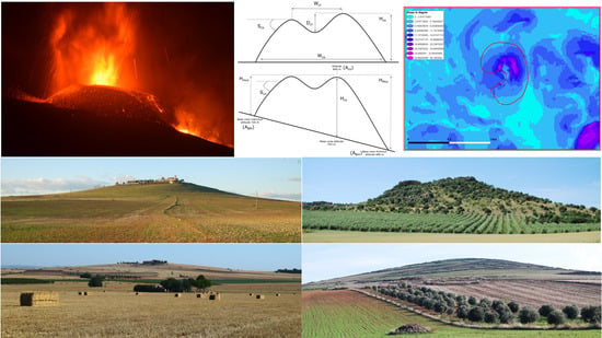
  • Cone height (Hco), calculated as the difference between the altitude of the top of the cone and the altitude of the base of the cone [3,4,5,7,12,14,21,23,26,27,29,30] for cones located in areas with flat topography (Figure 4). To calculate the height of cones located in areas with pronounced slopes where the base is at different altitudes (stratovolcanoes and volcanic rifts) or in mountain and piedmont areas (as in Campo de Calatrava), a method proposed by other authors was used [10,36,45] whereby the height is the difference between the altitude of the summit and the mean altitude of the volcano (Figure 5), calculated from the arithmetic mean of the altitudinal values of the base of the cone (minimum and maximum altitude) (Equation (1)) or of the maximum and minimum heights of the cone relative to the base (Equation (2)) [44].
    Hco = ½ [(Aco − ABm) + (Aco − ABM)]
    Hco = ½ (HMco − Hmco)
    where Aco is the altitude of the top of the cone, ABM is the maximum altitude of the base of the cone, ABm is the minimum altitude of the base, HMco is the maximum cone height, and Hmco is the minimum cone height.
  • Cone diameters, maximum (WMco), minimum (Wmco), and mean (or cone width Wco). These are calculated by comparing the volcano with a circumference or an ellipse, where the axes of the ellipse are the basal diameters of the volcanic edifice (Figure 6). To calculate the mean cone diameter (Wco), the arithmetic mean of the largest (WMco) and smallest (Wmco) diameters of the volcanic edifice is calculated using methods drawn from other authors [3,4,5,7,9,12,14,19,21,23,26,27,29,30].
  • Crater maximum (WMcr), minimum (Wmcr), and mean diameters (or crater width Wcr). These parameters are calculated following the model used for the cone diameters (Figure 6) [3,4,5,7,9,12,14,21,23,26,27,29,30].
  • Cone area (Aco), calculated automatically from the area occupied by the cone polygon in the geomorphological diagrams produced with GIS, based on topographic maps and aerial orthophotography [12,27,44,45].
  • Cone volume (Vco). Different formulae are used to calculate this parameter depending on whether or not the volcanic edifice still has a crater. Other morphometric parameters such as height, mean basal diameter and radius of the cone, and diameter and radius of the crater are also used.
    If the cone has no crater, the formula used to calculate the volume is the same as for the calculation of the volume of the geometric shape of an oblique cone. If the cone still has a crater, the geometric formula for calculating the volume of a truncated cone is used [9,10,12,23,27]. Volume is given in km3 in line with the unit of measurement used in the international literature.
    Vco with crater = 1/3 {π Hco [(Rco2 + rcr2) + (Rco × rcr)]}
    Vco without crater = 1/3 [π Hco × Rco2]
    where Hco is the cone height, Rco is the radius of the cone base (calculated as the half of the cone diameter = Wco/2), rcr is the radius of the cone crater (calculated as the half of the crater diameter = Wcr/2).
  • Number of craters (Ncr), identified in the cone morphology. For this purpose, a geomorphological scheme was drawn up beforehand. The ‘crater’ parameters (diameter, depth, elongation…) were calculated on the largest crater [9,44,45] in cones with more than one crater.
  • Crater depth (Dcr), is calculated by subtracting the minimum altitude of the crater from the altitude of the top of the cone, which coincides with the highest peak of the cone [9,10,14,23,26,30,76].
  • Cone maximum slope (Smaxco) corresponds to the maximum gradient in degrees from the highest point of the cone to its base [5,12,16,20,23,26,27,34,36,42]. These measurements were taken by generating a slope raster file from the DEM using the ArcMap Slope tool (Figure 7) [44]. The silhouette of the cone was superimposed on the slope raster and the steepest slope was then determined.
  • Cone slope (Sco), is the average slope of the entire surface of the volcanic edifice obtained by calculating the value of the α angle on the triangle outlined by the height and length of the volcano with respect to the horizontal line. It may be obtained from two methods: by using the cone to form a right-angled triangle and calculating the slope in degrees of one of its sides [8,44]; or by the method proposed by Hasenaka and Carmichael [12,27] and other authors [7,14,15,24,34,37,77,78]. It is calculated using the following equations:
    Sco without crater = tan−1 [2Hco/Wco]
    Sco with crater = tan−1 [2Hco/(Wco − Wcr)]
    where Hco is the cone height, Wco is the mean cone diameter and Wcr is the mean crater diameter.
  • Cone elongation (Eco) and crater elongation (Ecr). The ratio of the greatest to the smallest cone/crater diameter is calculated to determine whether or not the volcanic eruption that produced the volcanic edifice was a fissure eruption. According to Dóniz-Páez [8], the closer the value is to 1, the more rounded the cone will be; and the further away from 1, the more elongated it will be, especially for values higher than 1.5 [2,12,24,27,76,79,80,81].
  • Separation index between cones (SIco). Calculation of the distance between two volcanic edifices in close proximity to each other (Figure 8) from the distance measured from the geometric center of a cone to the geometric center of the nearest cone [3,5,7,12,27]. The calculations were performed through spatial analysis using the Proximity toolset in the ArcMap ArcToolbox package to generate and analyze distances between two points.

4. Results and Discussion

More than 180 volcanic landforms in the Campo de Calatrava Volcanic Region have been identified as cone-type monogenetic volcanoes (as per Kereszturi and Nemeth [16]) in the Campo de Calatrava Volcanic Region: nearly 160 scoria cones and some 30 spatter cones.
The scoria cones of CCVR were formed by Strombolian or violent Strombolian eruptions with emission of pyroclasts (ash, lapilli, scoria, bombs, and blocks), building up a truncated cone shape around the crater. These eruptions produced lava fountains and lava flows with pahoehoe and aa surface morphologies, and many spatter deposits that piled up on the slopes of some cones [44,50,65]. The analysis realized by Becerra-Ramírez [44] based on the morphological classification of monogenetic basaltic scoria cones [8,9,45], established the following morphologies in CCVR (Figure 9): ring-shaped cones (14.9% of the total cones analyzed), horseshoe-shaped cones (17.5%), multiple volcanoes (8.8%) and volcanoes without a crater—divided into pyroclastic mountains (39.8%) and spatter-lava mountains (19.3%).
The spatter cones in CCVR are the result of short effusive events generated in effusive fissure eruptions which formed small piles of highly welded and agglutinated spatter. The resulting morphologies (Figure 10) include small, agglutinated spatter cones, hornitos, and even rootless hornitos, as well as some short, thick lava flows. Because of their fragility, these small volcanic landforms are highly eroded and only the lava flow deposits remain, whereas the hornitos, rootless hornitos, and some spatter cones have disappeared almost completely [44,51].

4.1. Morphometric Analysis

The morphometric analysis of the parameters described in Section 3 was applied to 114 scoria cones (Figure 11), to characterize the morphological and morphometric distribution of these volcanoes to determine the most frequent cone of the Campo de Calatrava Volcanic Region. Although the main objective of this study is to identify the most frequent volcano-type of this volcanic field by analyzing the morphometric and morphological parameters of the most abundant monogenetic volcanoes (scoria cones), a morphometric analysis of 24 spatter cones has also been included for the purpose of comparing their dimensions with those of the larger cones.
Therefore, a morphometric analysis of 138 volcanoes, about 74% of the more than 180 volcanic landforms classified as cone-type, was carried out.
The rest of the cone-type morphologies identified, built by Strombolian and effusive eruptions, were not analyzed due to three main reasons:
  • they are old volcanoes (most of the dated volcanoes are older than 2.5 My [48,50,56,60]), and their forms are half-buried by sedimentary deposits in the Neogene basins or in the mountain ranges and piedmont by hillslope colluvium and other deposits [44], which makes it very difficult to correctly identify and analyze them morphometrically, as it happens in other volcanic fields [42];
  • they are ancient landforms that have lost all or most of the pyroclastic materials that formed the cone, and that now present extrusive—neck or dome—morphologies (as per Poblete et al. [65] and geological maps [47]);
  • they exhibit significant degradation as a result of extreme anthropogenic pressure (mining and extractive activity) on some cones, which has caused them to all but disappear, consequently making it impossible to measure morphometric parameters and to establish a morphological classification.
The overall data for the cone-type basaltic monogenetic volcanoes of CCVR are summarized in Table 1 and Figure 12 (only four main parameters), which presents descriptive statistical values—mean, typical error, median, mode, standard deviation, maximum, and minimum data—in line with the morphometric analysis presentation method of other authors [33,40,42,82].
Table 1. Descriptive statistical data for different morphometric parameters measured in the 114 scoria cones and 24 spatter cones analyzed on Campo de Calatrava Volcanic Region. Self-elaboration.
MeanTypical ErrorMedianModeStandard DeviationMinimumMaximumCounting *
Scoria cones
Hco36.542.0233.0017.0021.5410.00108.00114
Aco0.4540.0430.3270.1620.4550.0272.856114
Vco0.0081130.0010990.002937-0.0117340.0001420.055293114
114
WMco737.7132.02681.50514.00341.93229.002004.00114
Wmco612.1830.82572.00336.00329.10132.001887.00114
Wco674.9431.10626.25706.50332.06193.001945.50114
Ncr1.170.061.001.000.381.002.0047
WMcr218.4719.96181.00126.00136.833861847
Wmcr158.0015.46142.00142.00105.9526.00487.0047
Wcr188.2317.24163.5093.00118.1732.00521.5047
Dcr23.792.9520.005.0020.222.0080.0047
Smaxco15.850.6914.0010.007.345.0040.00114
Sco6.790.336.11-3.561.7216.57114
Eco1.270.021.201.260.231.001.99114
Ecr1.940.091.30-0.631.014.4847
SIco2410.24163.091990.001440.001741.38375.009323.00114
Spatter cones
Hco11.541.0010.0010.004.904.0024.0024
Aco0.0970.0190.0600.0350.0940.0070.33424
Vco0.0003400.0000740.000232-0.0003620.0000190.00156324
24
WMco362.6740.09292.00-196.4210776624
Wmco259.7528.34217.50-138.829855624
Wco311.2133.16261.75-162.46102.50634.0024
Ncr1.0001.001.0001.001.002
WMcr41.0039.0041.00-55.152.0080.002
Wmcr28.0026.0028.00-36.772542
Wcr34.5032.5034.50-45.962.0067.002
Dcr2.501.502.50-2.121.004.002
Smaxco12.211.4711.5016.007.213.0030.0024
Sco5.530.715,25-3.460.9014.8724
Eco1.410.081.30-0.371.062.7824
Ecr1.240.241.24-0.341.001.482
SIco2290.38374.031587.001389.001832.35375.008132.0024
Hco = cone height; Aco = area; Vco = volume of the cone; WMco = maximum cone diameter; Wmco = minimun cone diameter; Wco = mean cone diameter; Ncr = number of craters; WMcr = maximum crater diameter; Wmcr = minimum crater diameter; Wcr = mean crater diameter; Dcr = crater depth; Smaxco = maximum slope of the cone; Sco = cone average slope; Eco = cone elongation; Ecr = crater elongation; SIco = separation index. * For the parameters related to the crater, only those volcanoes that conserve the crater have been counted.
Figure 12. Frequency distribution histograms for scoria cones (a) and spatter cones (b) in the main parameters related to the cone size. Abbreviations: St. Dev., is the standard deviation; Min. and Max., are the minimum and maximum values. Self-elaboration.
Land 11 00917 g012
We can observe that the mean height for the 114 scoria cones analyzed (Table 1) is 36.54 m, with values ranging from 10 to 108 m, a median of 33.00 m, and a standard deviation of 21.54 m. The mean area is 0.454 km2, with values ranging from 0.027 to 2.86 km2, a median area of 0.327 km2 and a standard deviation of 0.455 km2. The mean volume is 0.008113 km3, with values between 0.000142 and 0.055293 km3, a median of 0.002937 km3 and a standard deviation of 0.011734 km3. For the average diameter of the cone, the results are a mean of 674.94 m, with values between 193 and 1945 m, a median of 626.25 m, and a standard deviation of 332.06 m. These data would indicate small cones when compared with cones from other volcanic fields on the planet [10,11,12,23,29,74]; moreover, they are highly eroded given their considerable age. This is confirmed by observing the distribution histograms of scoria cones in Figure 12a: according to their height, most of them are smaller than 60 m; most cones have an area of less than 0.850 km2 and an average width of less than 750 m; and most of the cones have a very small volume of only 0.008 km3.
These scoria cones have a mean number of craters of 1.17 (craters have only been observed in 47 cones) with a mean diameter of 188.23 m and a mean depth of 23.79 m, which, a priori, might seem relatively simple volcanic morphologies, without accounting for the fact that most of the volcanic edifices have lost their craters as a result of erosion. The cone maximum slope values give a mean of 15.85° and the mean value for cone slope is 6.79°, which is indicative of the significant erosion of these cones [44] as has occurred in other volcanic fields such as Bakony–Balaton Highland (Hungary) [16,19,38], which are similar to Calatrava in composition, chronology, morphogenesis, morphology, and erosion rates. In addition, the values for cone and crater elongation are not very high, with a mean of 1.27 for cones and 1.94 for craters, which suggests that the craters are a reflection of the fissure eruptions that formed these volcanoes and, in some cases, the existence of nested craters. Finally, the separation index—with a mean value of 2410.24 m—is consistent with platform volcanic fields analyzed in other volcanic regions [3,4,7,12].
In the case of the 24 spatter cones analyzed (Table 1 and Figure 12b), the mean data are a height of 11.54 m, a surface area of 0.097 km2, a volume of 0.00034 km3, and a basal diameter of 311.21 m, which reflects dimensions that are typically much smaller than in the case of scoria cones, as expected for this type of morphology classified as “small” (Figure 10) by the authors mentioned in Section 1 [3,10,16]. These data are also confirmed by observing at the histograms of spatter cone distribution (Figure 12b): according to their height, most of them are distributed between 8 and 16 m; most spatter cones have an area of less than 0.06 km2 and an average width of less than 330 m; and most of the cones have a very small volume of only 0.0003 km3. As for the craters, only two spatter cones still retain their crater, of very small dimensions, with a mean diameter of 34.5 m and depth of 2.5 m. The slopes are gentler, given that these are landforms that have been exposed to an important erosion, with a maximum of 12.21° and a mean of 5.53°. The elongations of the cone (1.41) and the crater (1.24) do not give very high values, although the spatter cones do have slightly higher values than for scoria cone elongation, which may reflect their Hawaiian/fissure formation, or that they formed on the flanks/piedmont of Paleozoic mountain ranges [44] (map in Figure 11) and, in some cases, at the edge of maars, tuff rings, or at the base of some scoria cones [43,50,83].
Given the small number of spatter cones (24 analyzed) and their small size, the enormous morphological differences between them, due to their poor state of preservation, would not faithfully reflect the morphological and morphometric values of the monogenetic volcanoes of CCVR, so it was decided not to include them in the subsequent analysis for defining the most frequent volcano-type.
As in other studies [9,84], mean and mode data are not sufficiently representative of the entire population of cone-type monogenetic volcanoes in CCVR. Therefore, a statistical analysis of the scoria cones based on the Pearson correlation coefficient [85] was performed to establish the relationship between two quantitative variables, as this is one of the statistical methods most widely used by various authors [4,26,77,86]. To check the results, we also applied the linear method of principal component analysis (PCA), which has also been used by several authors [33,82,87] to study the morphometry of scoria cones. These statistical analyses, which establish the linear relationship between two or more variables, are used to reduce the number of variables (in our study, morphometric parameters) that best correlate with each other and that would therefore be the most representative of the morphology and dimensions of the volcano. The results obtained vary between 1 and −1, and the closer the result is to 1 or −1, the closer the correlation between both quantitative parameters. Results close to 0 would indicate that the parameters do not correlate or that there is simply no relationship.
Correlations were performed only on scoria cones as they are the most repeated landform within the classification of cone-type monogenetic volcanoes (Table 2) in the Campo de Calatrava Volcanic Region.
Applying the correlation coefficient to the 16 variables used for the morphometric analysis and for the volcano-type definition (Table 2), ‘significant’ or ‘strong’ correlations are taken to be >0.50, and it can be seen that six parameters (Ncr, Smaxco, Sco, Eco, Ecr, and SIco) show only two or no correlations higher than 0.50. However, there are stronger correlations between the remaining 10 quantitative parameters (Hco, Aco, Vco, Wco, Wcr, Dcr), with between four and seven positive correlations higher than 0.50. As in other studies [9,84], the positive correlations are moderate in general, although stronger between the parameters Hco, Aco, Vco, and Wco (>0.76) (Table 2).
To confirm that the variables extracted with the Pearson correlation analysis are optimal for the definition of the volcano-type following de morphological and morphometric distribution of the scoria cones, principal component analysis (PCA) was additionally applied to the 16 morphometric parameters used for this characterization (Table 3). As in the Pearson analysis (Table 2), correlations of >0.50 between the different variables (marked in red in the component matrix in Table 3) have been taken as significant. The first four variables (Hco, Aco, Vco and WMco) have eigenvalues >1 and account for 81.69% of the variability. The next two variables (Wmco, Wco) have eigenvalues between >0.68 and <1 and account for 91.47% of the variability of the PCA.
In the principal component matrix (Table 3) we can see that, in component 1, the variables that better correlate (>0.60 and 0.80) are the parameters Hco, Aco, Vco, WMco, Wmco, and Wco. The parameters WMcr, Wmcr, and Wcr also give strong correlations (>0.80) but have lower eigenvalues and account for 99.3% of the variability.
Furthermore, each of the components obtained could be correlated with a key morphological descriptor [82], depending on the data obtained. In our study, only two of the components have three or more parameters that provide significant correlation results:
  • Component 1—Size: the nine parameters that offer the strongest correlations (>0.80 and height 0.608) are closely related to the description of the size of volcanic cones—namely height, area, and volume—and the dimensions of the cone base and craters which, to some extent, are also related to the dimensions of the volcanic edifice.
  • Component 2—Steepness: the three parameters that give the best results are those related to the maximum and average slope and height of the cone, so this component explains the steepness of the cone and, to a certain extent, its relationship with the erosion of the volcano.
  • Component 3—Craters: only the number of craters variable gives a strong correlation.
  • Component 4—Crater shape: only the crater elongation parameter shows a strong correlation.
Once the Pearson correlation analysis had been performed and checked against the PCA, the parameters that most closely matched each other were selected in order to establish modal intervals for defining the Calatrava volcano-type, following the morphological and morphometric distribution of the scoria cones.

4.2. Defining the ‘Volcano-Type’ of Campo de Calatrava Volcanic Region

As indicated in Section 1, qualitative (morphology, location, size of the cone) and quantitative data obtained through morphometric analysis (Hco, Aco, Vco, Wco, Wcr, Dcr, Ncr, Dcr, etc.) were used to define the most frequent cone-type basaltic monogenetic volcano in the Campo de Calatrava Volcanic Region (Table 4 and Table 5).
To define the qualitative data, we used the findings reported by Becerra-Ramírez [44] on the distribution of the scoria cones, according to their morphology, topographic location, and size. With these data, we can determine which morphology is the most frequent in CCVR, in which topographical location and which size, following the method of Dóniz-Páez et al. [9] (Table 4).
Once the qualitative attributes had been established, we chose those that occur most frequently in the cone-type volcanoes of Calatrava. On this point, and as we saw earlier, a first analysis would rule out the inclusion of spatter cones in the qualitative attributes, given the small number of volcanoes of this typology (24 analyzed) and their variability in terms of shape, state of preservation, and their small size, which would not faithfully reflect the morphological and morphometric values of the cone-type monogenetic volcanoes of CCVR. Therefore, Pearson correlations and PCA (Table 2 and Table 3) for qualitative attributes were only performed on the 114 scoria cones analyzed.
For the quantitative attributes, a modal intervals method [9,84] (Table 5) was used for each of the morphometric parameters that had the strongest correlation with the Pearson coefficient and its comparison against the PCA: height, area, volume, and cone and crater diameters. Each of the modal intervals are representative of the real dimensions of the cones studied [9,84], and for each parameter we chose the modal interval in which the largest number of cones was distributed, which is therefore the most representative sample of the ranges of height, area, volume, and cone and crater diameters in the set of scoria cones surveyed in CCVR.
Once the quantitative and qualitative attributes described in Table 4 and Table 5 had been determined, according to the morphometric parameters that define the dimensions, topographic location, and size of the cones, we were able to identify the most frequent scoria cones in the Campo de Calatrava Volcanic Region. Taking into account the modal intervals for both quantitative and qualitative attributes, it can be observed that in many cases they represent more than 50% of the distribution of the scoria cones analyzed in CCVR. This method therefore enables us to obtain a close approximation to the morphological features of the basaltic monogenetic volcanoes [9,84].
From the findings presented in Table 4 and Table 5, we may infer that the most frequent monogenetic basaltic volcano in the Campo de Calatrava Volcanic Region is a craterless ash-dominated volcanic cone, mostly located in flat or basin areas, and of small size—that is, with a height less than 50 m, an area less than 0.6 km2, a volume of less than 0.01 km3—and with a basal diameter between 500 and 1000 m. These modal values match the averages presented in Table 1 and Figure 12a, which were: height 36.54 m, surface area 0.454 km2, volume 0.008113 km3 and mean cone diameter of 674.94 m. In keeping with this Campo de Calatrava ‘volcano-type’, we note that the most frequent morphologies in this volcanic field are known by the local toponym of cabezo or cabeza [50,51,88], which are highly eroded flattened volcanic hills with little topographic reflection in the middle of the central Neogene plains of the region (Figure 13a,b).
These morphological features therefore reflect the current state of most of the cones surveyed in CCVR: old, highly eroded volcanoes that have lost part of their original morphological and morphometric values as a result of the processes of degradation. We cannot affirm, then, that this is the original shape of a newly formed monogenetic basaltic volcano in this volcanic field, but rather the result of its intense erosion, or its morphological modification by syn- and post-eruptive events (volcanic or otherwise) after its formation, as occurs in other volcanic fields [19,39,42].
However, if we wanted to determine what these cones were mostly like when they first formed, we would have to look at the results of the analysis applied to the scoria cones that still have a crater. The crater, therefore, would be the morphological evidence of the original shape of these volcanoes produced in Strombolian paroxysms and effusive pulses (Figure 1). Based on the number of volcanoes that still remain a crater, and taking into account the values in Table 4 and Table 5, we could therefore state that the volcano-type with a crater in CCVR is a horseshoe-shaped scoria cone (Figure 13c,d), located in areas of flat or contrasting topography (piedmont), corresponding to the main emplacement of this morphological type [44]. It is a small cone: height <50 m, area less than 0.6 km2, volume less than 0.01 km3, basal diameter of between 500 and 1000 m, and mean crater diameter of between 25 and 145 m.

5. General Discussion

In the Campo de Calatrava Volcanic Region, the purpose of establishing a volcano-type is to learn about the structural and spatial aspect of these landforms and the type of eruptive behavior that a volcanic edifice of these characteristics would have within the volcanic field, in other words, to provide a statistical explanation of what an ‘ideal’ scoria cone would be like, following the current distribution of these volcanoes from the morphometric and morphological points of view. Other studies use this method to address hazard assessment and risk analysis in the event of a monogenetic basaltic eruption [9,84]. Although CCVR is considered volcanically active [61], to speak of hazards associated with a volcanic eruption would not be entirely accurate, as the last eruption occurred between 14 ka and 5.5 ka BP [57,58,59,60].
To determine the volcano-type of the Campo de Calatrava Volcanic Region, a selection of qualitative morphological parameters was established by taking as a reference the attribute that distributed the highest number of cones. The quantitative morphometric indices were selected using Pearson linear correlations checked against PCAs to narrow down the number of morphometric parameters that best define the morphology of the cones. To this end, only indices with strong and/or moderate positive correlations (>0.50) were selected, while negative and weak correlations were rejected. This ensures that there is an association between the variables studied and a high degree of objectivity in the results obtained with this method [9].
However, for the characterization of the cone-type monogenetic volcano in CCVR, the lesser morphologies (spatter cones) were ruled out, even though they belong to this morphogenetic typology, since they present very diverse and disparate forms, highly eroded, partially buried, with hardly any morphological reflection and, most importantly, only about 30 of these landforms still remain as compared to the greater number of scoria cones in the volcanic region.
The methodology applied reveals the most significant morphological features of the scoria cones of Calatrava, representing the most frequent eruptive morphologies in its recent geological past, as well as one of the most representative values of the geodiversity, geoheritage, and landscape heritage of this area of central Spain.
On the basis of the data obtained, the most frequent scoria cone in CCVR is an ash-dominated, craterless volcanic cone, located in flat areas and of small size (height < 50 m, area < 0.6 km2, volume < 0.01 km3 and a mean basal diameter between 500 and 1000 m); the modal results are consistent with the averages obtained for the surveyed scoria cones (36.54 m height, 0.454 km2 area, 0.008113 km3 volume, and cone diameter 674.94 m). This Calatrava ‘volcano-type’ resulting from the analysis is consistent with the volcanic hills known locally as cabezos or cabezas.
This landform is the result of intense erosive processes over millions of years. The craters of these volcanoes have disappeared and their size is very small, which suggests that part of the eruptive material that formed the cone has been stripped away—especially the smaller pyroclasts (ash, lapilli), as reflected in the mean, mode, and median data, as well as in the modal intervals used to characterize the volcano-type. Moreover, this situation is confirmed in similar volcanic fields when “most explosive cones are built up mostly by loose lapilli and ash as well as minor, e.g., locally distributed, lava spatter, favoring rapid erosion” [19].
For these reasons, it is considered that volcanoes that still retain their craters should also be taken into account to characterize the original CCVR ‘volcano-type’, since craterless cones are the result of the erosional evolution of the cones with crater. Therefore, to determine what these cones were mostly like when they were formed, we have to focus on the analysis applied to the scoria cones that still have a crater. Following the same methodology and based on the findings, the most frequently repeated volcano-type with a crater in CCVR is a horseshoe-shaped scoria cone located in areas of flat or contrasting topography (piedmont or hillside) and of small size.
It is true that this method is relatively simple for volcanic fields such as Campo de Calatrava, with a great variety of more-or-less eroded volcanic morphologies given the old age of many of them and the relative youth of others. One reason is that the distribution of the most volcanoes that occur in the modal intervals have lost much of their original form, which is reflected in alterations in the morphometric parameters of height, basal diameter, surface area, and volume, and in other parameters such as loss of craters and slope decrease. In general, the results of these alterations are morphological features and erosion rates that are modified by “properties that result from the interaction of syn- and post-eruptive processes (effusive and phreatomagmatic activity, erosion, the slope of the pre-eruptive surface)” [42], or “erosion-resistant components” which has also “played an important role on slope processes and thus morphometry […] e.g., dominant effusive activity, different deposits preserved in the scoria cone successions […] welded or agglutinated deposits” [19]. It could even be suggested that the “differences in cone shape are also due to different degradation styles and rates. Even cones in the same field that have large differences in age can display contrasting mean erosion rates due to past climatic changes” as other studies note [39].
On the other hand, the other 49% of the basaltic monogenetic volcanoes of CCVR formed in hydromagmatic eruptions—especially maars, maars-diatreme, and tuff rings—were not studied. Even maars would be more frequent as single landforms, but a thorough morphological and morphometric characterization of maars would be necessary. There is a previous morphometric, hydrogeographic, and ecosystemic survey that analyzed only 27 of these landforms that contain a shallow lake in their interior [44], only 15.4% of the more than 175 hydromagmatic craters identified in the Campo de Calatrava Volcanic Region. Another recent study extended the morphometric survey to 43 maars [83], only 24.6% of the Campo de Calatrava total.
Another fact that should be taken into account to complete this type of study is the presence of combined landforms resulting from eruptions that alternate Strombolian effusive pulses (e.g., Figure 1) with hydromagmatic pulses and/or phases [11,19,40,41], in which volcanic complexes of different morphological features develop in the same eruptive paroxysm (e.g., scoria cone-maar-spatter cone). These eruptive complexes show that monogenetic volcanoes are highly variable in both form and composition, and that there might be a transition from simple scoria cones to long-lived polygenetic volcanoes [41] or monogenetic volcanoes with polycyclic behavior [16,89].
One of the best examples of such combined landforms in CCVR is the Cerro Gordo-Barondillo-La Sima eruptive complex (Figure 14). This is a complex formed in several eruptive pulses alternating between Strombolian, hydromagmatic, and effusive [90], which may be classified as maar/scoria cone or maar/tuff-ring complex with scoria cone and spatter cone, according to the classification of Kereszturi and Németh [16]. Moreover, this eruptive complex shows a high geodiversity, as one of the most outstanding elements of the geoheritage of the volcanic field, which is why it is included in the Geological Interest Sites Inventory of the Spanish Geological Survey—IGME (IELIG TM146) [91], and as a geosite within the “Calatrava Volcanoes. Ciudad Real” Geopark project [72]. In addition, it should be declared as a natural protected area in the category of Natural Monument (pursuant to the Nature Conservation Law of Castilla-La Mancha [92]).

6. Final Remarks

Characterization of the monogenetic basaltic volcanoes is needed not only as individual landforms, but also in those cases where volcanic complexes have emerged involving different eruptive pulses and phases in which some are more predominant than others. It would thus be possible to determine a volcanic morphology ‘type’, or several types, depending on the eruption style or styles and the final morphological features, closer to the real and intact morphology of the more recent volcanoes of the Campo de Calatrava, or if a volcanic eruption were to occur in this territory in the very long term.
Morphometric studies can also be used to analyze the geodiversity and geoheritage of volcanic cones and other landforms [46], especially when applying new surveying techniques, tools such as GIS, or high-resolution geographic information such as DEMs [41]. These tools would be useful in characterizing the geomorphological heritage of the “Calatrava Volcanoes. Ciudad Real” Geopark project [70,71,72], as it would help us to better understand how the volcanoes were formed, what interactions they had, the risks associated with this type of natural hazard, and the symbiosis generated after centuries of human occupation that has exploited these landforms and their materials [93] and, in short, the landscape with which the local population identifies.
This type of morphological and morphometric analysis should be taken into consideration, especially for volcanoes that are undergoing major degradation without due account being taken of their geological values (genesis, petrology, geochemistry), geomorphological values (morphology, location, spatial distribution, size, association with other volcanic or non-volcanic landforms), their connection with other natural elements linked to biodiversity and ecosystems (volcanic shallow lakes) and the relationship that human societies have had with these volcanoes, reflecting the idiosyncrasies of the cultures that have used them over the centuries. Some examples of this situation are the scoria cones of Cerro Gordo (Figure 14), La Yezosa, Columba (Figure 9a,b), and Cabezo Segura.
The use of morphometric analysis to classify volcano-type may also serve for future purposes, in view of the results and the discussion:
  • Apply the morphometric analysis to landforms produced by hydromagmatic eruptions (maars, maars-diatreme, tuff rings), thereby adding to the number of volcanoes of this type that have been previously surveyed [43,83];
  • Analyze eruptive complexes where several overlapping landforms occur (scoria cones, spatter cones, maar), produced by eruptive pulses of different kinds, to determine whether there are other ‘volcano-types’;
  • Model the morphological evolution of these volcanoes within the landscape, as part of the natural heritage (geoheritage/geomorphological heritage);
  • Include these qualitative and quantitative analyses in the study of the geoheritage and landscape heritage of the Calatrava volcanoes, with a view to their being designated as a UNESCO global geopark. Even more so in a project within a region where the leading attraction is the volcanoes, their morphological imprint on the landscape, the natural resources they offer (fertile soils, hot springs, ecosystems), the use they have been put to throughout history (mining, agriculture, geotourism and volcano tourism), and their sustainable management (geoconservation and protection);
  • Develop sustainable management tools for the region covered by this project, taking into account the most representative and best-preserved volcanic landforms.

Author Contributions

Conceptualization, R.B.-R., J.D.-P. and E.G.; Methodology, R.B.-R. and J.D.-P.; Geographical information systems, R.B.-R.; Investigation, R.B.-R.; Writing—original draft preparation, R.B.-R.; Writing and editing, R.B.-R.; Review, R.B.-R., J.D.-P. and E.G.; Supervision, J.D.-P. and E.G.; Project administration and funding acquisition, R.B.-R. and E.G. All authors have read and agreed to the published version of the manuscript.

Funding

The previous research work was developed thanks to a Research Personnel Training Grant, facilitated by a public call from the Consejería de Educación y Ciencia of the Government of Castilla-La Mancha (Spain) (Expte. 06/094). In addition, part of the fieldwork was carried out thanks to the University of Castilla-La Mancha (Spain) Research Grants (Ref. AT-20070104).

Institutional Review Board Statement

Not applicable.

Informed Consent Statement

Not applicable.

Acknowledgments

The English translation of this article has been covered by the Facultad de Letras of the University of Castilla-La Mancha (Spain). We want to thank Agnès Louart Traducciones for their translation services. In addition, we would like to acknowledge the suggestions and changes proposed by the reviewers of this paper.

Conflicts of Interest

The authors declare no conflict of interest.

References

  1. McDonald, G.A. Volcanoes; Prentice-Hall: Englewood Cliffs, NJ, USA, 1972. [Google Scholar]
  2. Pike, R.J. Volcanoes on the inner planets: Some preliminary comparisons of gross topography. In Proceedings of the Lunar and Planetary Science Conference, 9th, Houston, TX, USA, 13–17 March 1978; Pergamon Press Inc.: New York, NY, USA, 1978; Volume 3, pp. 3239–3273. [Google Scholar]
  3. Settle, M. The structure and emplacement of cinder cone fields. Am. J. Sci. 1979, 279, 1089–1107. [Google Scholar] [CrossRef]
  4. Wood, C.A. Morphometric evolution of cinder cones. J. Volcanol. Geotherm. Res. 1980, 7, 387–413. [Google Scholar] [CrossRef]
  5. Wood, C.A. Morphometric analysis of cinder cone degradation. J. Volcanol. Geotherm. Res. 1980, 8, 137–160. [Google Scholar] [CrossRef]
  6. Sigurdsson, H.; Houghton, B.; McNutt, S.; Rymer, H. (Eds.) Encyclopedia of Volcanoes; Academic Press: San Diego, CA, USA, 2000. [Google Scholar]
  7. Inbar, M.; Risso, C. A morphological and morphometric analysis of high cinder cone volcanic field–Payun Matru, south-central Andes, Argentina. Z. Für Geomorphol. 2001, 45, 321–344. [Google Scholar] [CrossRef]
  8. Dóniz-Páez, J. Caracterización Geomorfológica del Volcanismo Basáltico Monogénico de la Isla de Tenerife. Ph.D. Thesis, Universidad de La Laguna, Tenerife, Spain, 2004. [Google Scholar]
  9. Dóniz, J.; Romero, C.; Coello, E.; Guillen, C.; Sánchez, N.; García-Cacho, L.; García, A. Morphological and statistical characterisation of recent mafic volcanism on Tenerife (Canary Islands, Spain). J. Volcanol. Geotherm. Res. 2008, 173, 185–195. [Google Scholar] [CrossRef]
  10. Dóniz-Páez, J.; Romero, C.; Sánchez, N. Quantitative size classification of scoria cones: The case of Tenerife (Canary Islands, Spain). Phys. Geogr. 2013, 33, 514–535. [Google Scholar] [CrossRef]
  11. Németh, K.; Kereszturi, G. Monogenetic volcanism: Personal views and discussion. Int. J. Earth Sci. (Geol. Rundsch.) 2015, 104, 2131–2146. [Google Scholar] [CrossRef]
  12. Hasenaka, T.; Carmichael, I. The cinder cones of Michoacán-Guanajato, central Mexico: Their age, volume, distribution and magma discharge rate. J. Volcanol. Geotherm. Res. 1985, 25, 105–124. [Google Scholar] [CrossRef]
  13. Cas, R.A.F.; Wright, J.V. Volcanic Successions, Modern and Ancient; Chapman & Hall: London, UK, 1987. [Google Scholar]
  14. Hooper, D.; Sheridan, M. Computer-simulation models of scoria cone degradation. J. Volcanol. Geotherm. Res. 1998, 83, 241–267. [Google Scholar] [CrossRef]
  15. Martens, U. Aspectos morfométricos de los conos de escoria de Costa Rica. Rev. Geológica De América Cent. 2004, 30, 15–29. [Google Scholar] [CrossRef] [Green Version]
  16. Kereszturi, G.; Németh, K. Monogenetic Basaltic Volcanoes: Genetic Classification, Growth, Geomorphology and Degradation. In Updates in Volcanology. New Advances in Understanding Volcanic Systems; Németh, K., Ed.; IntechOpen: London, UK, 2012; pp. 3–89. [Google Scholar]
  17. Vesperman, D.; Schmincke, H.U. Scoria cones and tuff rings. In Encyclopedia of Volcanoes; Sigurdsson, H., Houghton, B.F., McNutt, S.R., Reymer, H., Stix, J., Eds.; Academic Press: San Diego, CA, USA, 2000; pp. 683–694. [Google Scholar]
  18. Walker, G.P.L. Basaltic volcanoes and volcanic systems. In Encyclopedia of Volcanoes; Sigurdsson, H., Houghton, B.F., McNutt, S.R., Reymer, H., Stix, J., Eds.; Academic Press: San Diego, CA, USA, 2000; pp. 283–289. [Google Scholar]
  19. Kereszturi, G.; Németh, K. Structural and morphometric irregularities of eroded Pliocene scoria cones at the Bakony-Balaton Highland Volcanic Field, Hungary. Geomorphology 2012, 136, 45–58. [Google Scholar] [CrossRef]
  20. Kereszturi, G.; Jordan, G.; Németh, K.; Dóniz-Páez, J. Syn-eruptive morphometric variability of monogenetic scoria cones. Bull. Volcanol. 2012, 74, 2171–2185. [Google Scholar] [CrossRef]
  21. Dohrenwed, J.; Wells, S.; Turrin, B. Degradation of Quaternary cinder cones in the Cima volcanic field, Mojave Desert, California. Geol. Soc. Am. Bull. 1986, 97, 421–427. [Google Scholar] [CrossRef]
  22. Hooper, D. Computer-simulation models of scoria cone degradation in the Colima and Michoacán–Guanajuato volcanic fields, Mexico. Geofísica Int. 1995, 34, 321–340. [Google Scholar]
  23. Carn, S.A. The Lamongan volcanic field, East Java, Indonesia: Physical volcanology, historic activity and hazards. J. Volcanol. Geotherm. Res. 2000, 95, 81–108. [Google Scholar] [CrossRef]
  24. Corazzato, C.; Tibaldi, A. Fracture control on type, morphology and distribution of parasitic volcanic cones: An example from Mt. Etna, Italy. J. Volcanol. Geotherm. Res. 2006, 158, 177–194. [Google Scholar] [CrossRef]
  25. Tibaldi, A. Morphology of pyroclastic cones and tectonics. J. Geophys. Res. 1995, 100, 24521–24535. [Google Scholar] [CrossRef]
  26. Porter, S. Distribution, morphology, and size frequency of cinder cones on Mauna Kea volcano, Hawaii. Geol. Soc. Am. Bull. 1972, 83, 3607–3612. [Google Scholar] [CrossRef]
  27. Hasenaka, T.; Carmichael, I. A compilation of location, size and geomorphological parameters of volcanoes of Michoacán–Guanajato Volcanic Field, Central Mexico. Geofísica Int. 1985, 24, 577–607. [Google Scholar]
  28. Márquez, A.; Verma, S.; Anguita, F.; Oyarzun, R.; Brandle, J. Tectonics and volcanism of Sierra Chichinautzin: Extension at the front of the Central Trans-Mexican Volcanic Belt. J. Volcanol. Geotherm. Res. 1999, 93, 125–150. [Google Scholar] [CrossRef]
  29. Martín del Pozzo, A. Monogenetic volcanism in Sierra Chichinautzin, Mexico. Bull. Volcanol. 1982, 45, 9–24. [Google Scholar] [CrossRef]
  30. Karátson, D. Rates and factors of stratovolcano degradation in a continental climate: A complex morphometric analysis for nineteen Neogene/Quaternary crater remnants in the Carphatians. J. Volcanol. Geotherm. Res. 1996, 73, 65–78. [Google Scholar] [CrossRef]
  31. Fornaciai, A.; Behncke, B.; Favalli, M.; Neri, M.; Tarquini, S.; Boschi, E. Detecting short-term evolution of Etnean cinder cones: A LIDAR-based approach. Bull. Volcanol. 2010, 72, 1209–1222. [Google Scholar] [CrossRef]
  32. Romero, C. El Relieve de Lanzarote; Cabildo de Lanzarote: Tenerife, Spain, 2003. [Google Scholar]
  33. Uslular, G.; Le Corvec, N.; Mazzarini, F.; Legrand, D.; Gençalioğlu-Kuşcu, G. Morphological and multivariate statistical analysis of quaternary monogenetic vents in the Central Anatolian Volcanic Province (Turkey): Implications for the volcano-tectonic evolution. J. Volcanol. Geotherm. Res. 2021, 416, 107280. [Google Scholar] [CrossRef]
  34. Hasenaka, T. Size, distribution and magma output rate for shield volcanoes of the Michoacán-Guanajato volcanic field, Central Mexico. J. Volcanol. Geotherm. Res. 1994, 63, 13–31. [Google Scholar] [CrossRef]
  35. Karátson, D. Erosion of primary volcanic depressions in the Inner Carpathian Volcanic Chain. Z. Für Geomorphol. Suppl. 1999, 114, 46–62. [Google Scholar]
  36. Favalli, M.; Karátson, D.; Mazzarini, F.; Pareschi, M.T.; Boschi, E. Morphometry of scoria cones located on a volcano flank: A case study from Mt. Etna (Italy), based on high-resolution LiDAR data. J. Volcnaology Geotherm. Res. 2009, 186, 320–330. [Google Scholar] [CrossRef]
  37. Inbar, M.; Gilichinsky, M.; Melekestev, I.; Melnikov, D.; Zaretskaya, N. Morphometric and morphological development of Holocene cinder cones: A field and remote sensing study in the Tolbachik volcanic field, Kamchatka. J. Volcanol. Geotherm. Res. 2011, 201, 301–311. [Google Scholar] [CrossRef]
  38. Kereszturi, G.; Németh, K. Shallow-seated controls on the evolution of the Upper Pliocen Kopasz-hegy nested monogenetic volcanic chain in the Western Pannonian Basin (Hungary). Geol. Carpathica 2011, 62–66, 535–546. [Google Scholar] [CrossRef]
  39. Fornaciai, A.; Favalli, M.; Karátson, D.; Tarquini, S.; Boschi, E. Morphometry of scoria cones, and their relation to geodynamic setting: A DEM-based analysis. J. Volcanol. Geotherm. Res. 2012, 217–218, 56–72. [Google Scholar] [CrossRef]
  40. Grosse, P.; Ochi, M.L.; Escalante, F.; Guzmán, S.; Orihashi, Y.; Sumino, H. Geomorphology, morphometry, spatial distribution and ages of mafic monogenetic volcanoes of the Peinado and Incahuasi fields, southernmost Central Volcanic Zone of the Andes. J. Volcanol. Geotherm. Res. 2020, 401, 106966. [Google Scholar] [CrossRef]
  41. Vörös, F.; van Wyk de Vries, B.; Karátson, D.; Székely, B. DTM-Based Morphometric Analysis of Scoria Cones of the Chaîne des Puys (France)—The Classic and a New Approach. Remote Sens. 2021, 13, 1983. [Google Scholar] [CrossRef]
  42. Aguilera, M.; Ureta, G.; Grosse, P.; Németh, K.; Aguilera, F.; Vilches, M. Geomorphological, morphometric, and spatial distribution analysis of the scoria cones in the Negros de Aras monogenetic volcanic field, northern Chile. J. Volcanol. Geotherm. Res. 2022, 422, 107458. [Google Scholar] [CrossRef]
  43. Gosálvez, R.U. Análisis Biogeográfico de las Lagunas Volcánicas de la Península Ibérica. Ph.D. Thesis, UCLM, Ciudad Real, Spain, 2011. Available online: http://hdl.handle.net/10578/3246 (accessed on 20 March 2022).
  44. Becerra-Ramírez, R. Geomorfología y Geopatrimonio de los Volcanes Magmáticos de la Región Volcánica del Campo de Calatrava. Ph.D. Thesis, UCLM, Ciudad Real, Spain, 2013. Available online: http://hdl.handle.net/10578/3606 (accessed on 24 March 2022).
  45. Dóniz-Páez, J. Volcanic geomorphological classification of the cinder cones of Tenerife (Canary, Islands, Spain). Geomorphology 2015, 228, 432–447. [Google Scholar] [CrossRef]
  46. Vörös, F.; Pál, M.; van Wyk de Vries, B.; Székely, B. Development of a New Type of Geodiversity System for the Scoria Cones of the Chaîne des Puys Based on Geomorphometric Studies. Geosciences 2021, 11, 58. [Google Scholar] [CrossRef]
  47. Cartografía Geocientífica. Spanish Geological Survey (IGME). Available online: http://www.igme.es/actividadesIGME/lineas/cartoGeo.htm (accessed on 24 March 2022).
  48. Ancochea, E. Evolución Espacial y Temporal del Volcanismo Reciente de España Central. Ph.D. Thesis, UCM, Madrid, Spain, 1983. [Google Scholar]
  49. López-Ruiz, J.; Cebriá, J.M.; Doblas, M.; Oyarzum, R.; Hoyos, M.; Martín, C. Cenozoic intra-plate volcanism related to extensional tectonics at Calatrava, central Iberia. Geol. Soc. 1993, 150, 915–922. [Google Scholar] [CrossRef]
  50. Poblete, M.A. El Relieve Volcánico del Campo de Calatrava (Ciudad Real); University of Oviedo and JCCM: Oviedo, Spain, 1995. [Google Scholar]
  51. Becerra-Ramírez, R.; Gosálvez, R.U.; Escobar, E.; González, E.; Serrano-Patón, M.; Guevara, D. Characterization and Geotourist Resources of the Campo de Calatrava Volcanic Region (Ciudad Real, Castilla-La Mancha, Spain) to Develop a UNESCO Global Geopark Project. Geosciences 2020, 10, 441. [Google Scholar] [CrossRef]
  52. García, J.L. Mapa Geomorfológico de la Comarca de Los Montes-Campo de Calatrava: E: 1:200,000; UCLM: Madrid, Spain, 1994. [Google Scholar]
  53. Cebriá, J.M.; López Ruíz, J. Alkali basalts and leucitites in an extensional intracontinental plate setting: The late Cenozoic Calatrava Volcanic Province (Central Spain). Lithos 1995, 35, 27–46. [Google Scholar] [CrossRef]
  54. Cebriá, J.M.; López Ruíz, J. A refined method for trace element modelling of nonmodal batch partial melting processes: The Cenozoic continental volcanism of Calatrava, Central Spain. Geochim. Cosmochim. Acta 1996, 60, 1355–1366. [Google Scholar] [CrossRef]
  55. García Serrano, J.; Villaseca, C.; Pérez-Soba, C. Depleted lherzolite xenoliths from the leucititic Morrón de Villamayor volcano (Calatrava volcanic field, Spain). Lithos 2021, 380–381, 105830. [Google Scholar] [CrossRef]
  56. Ancochea, E.; Huertas, M.J. Radiometric ages and time–space distribution of volcanism in the Campo de Calatrava Volcanic Field (Iberian Peninsula). J. Iber. Geol. 2021, 47, 209–223. [Google Scholar] [CrossRef]
  57. González, E.; Gosálvez, R.; Becerra-Ramírez, R.; Escobar, E. Condiciones Medioambientales en el Holoceno Medio del Campo de Calatrava Oriental (Ciudad Real, España): Resultados Preliminares; Actas del IX Congreso Nacional de Biogeografía: Ávila, Spain, 2006. [Google Scholar]
  58. González, E.; Gosálvez, R.; Becerra-Ramírez, R.; Escobar, E. Actividad eruptiva holocena en el Campo de Calatrava (Volcán Columba, Ciudad Real, España). In Contribuciones al Estudio del Período Cuaternario; Lario, J., Silva, G., Eds.; Aequa: Ávila, Spain, 2007; pp. 143–144. [Google Scholar]
  59. Poblete, M.A.; Ruíz, J. Revisión de la edad del volcanismo en la región volcánica central de España: Evidencias geomorfológicas de actividad volcánica cuaternaria. In Contribuciones al Estudio del Período Cuaternario; Lario, J., Silva, G., Eds.; Aequa: Ávila, Spain, 2007; pp. 163–164. [Google Scholar]
  60. Poblete, M.A.; Martí, J.; Beato, S.; Marino, J.L. Geomorphological evolution and chronology of the eruptive activity of the Columba and Cuevas Negras volcanoes (Campo de Calatrava Volcanic Field, Ciudad Real, Central Spain). Geomorphology 2019, 336, 52–64. [Google Scholar] [CrossRef] [Green Version]
  61. Calatrava Volcanic Field. Global Volcanism Program. National Museum of Natural History, Smithsonian Institution (USA). Available online: https://volcano.si.edu/volcano.cfm?vn=210040 (accessed on 7 April 2022).
  62. Calvo, D.; Barrancos, J.; Padilla, G.; Brito, M.; Becerra-Ramírez, R.; Gosálvez, R.; González, E.; Escobar, E.; Melián, G.; Nolasco, D.; et al. Emisión difusa de CO2 en el Campo de Calatrava. In Aportaciones Recientes en Volcanología, 2005–2008; González, E., Escobar, E., Becerra-Ramírez, R., Gosálvez, R., Dóniz, J., Eds.; Centro de Estudios Calatravos: Ciudad Real, Spain, 2010; pp. 51–52. [Google Scholar]
  63. Elío, J.; Ortega, M.F.; Nisi, B.; Mazadiego, L.F.; Vaselli, O.; Caballero, J.; Grandi, F. CO2 and Rn degassing from the natural analog of Campo de Calatrava (Spain): Implications for monitoring of CO2 storage sites. Int. J. Greenh. Gas Control 2015, 32, 1–14. [Google Scholar] [CrossRef] [Green Version]
  64. Nisi, B.; Vaselli, O.; Elio, J.; Giannini, L.; Tassi, F.; Guidi, M.; Darrah, M.; Maletic, E.L.; Delgado, A.; Marchionni, S. The Campo de Calatrava Volcanic Field (central Spain): Fluid geochemistry in a CO2-rich area. Appl. Geochem. 2019, 102, 153–170. [Google Scholar] [CrossRef] [Green Version]
  65. Poblete Piedrabuena, M.A.; Beato, S.; Marino, J.L. Landforms in the Campo de Calatrava Volcanic Field (Ciudad Real, Central Spain). J. Maps 2016, 12 (Suppl. 1), 271–279. [Google Scholar] [CrossRef] [Green Version]
  66. Araña, V.; Aparicio, A.; Martín Escorza, C.; García Cacho, L.; Ortíz, R.; Vaquer, R.; Barberi, F.; Ferrara, G.; Albert, J.; Gassiot, X. El volcanismo neógeno-cuaternario de Catalunya: Caracteres estructurales, petrológicos y geodinámicos. In Acta Geològica Hispànica; Consejo Superior de Instigaciones Cientificas (CSIC): Madrid, Spain, 1983; Volume 18, 1, pp. 16–17. Available online: http://hdl.handle.net/10261/7023 (accessed on 7 April 2022).
  67. Mazzarini, F.; Armienti, P. Flank cones at Mount Etna Volcano: Do they have a power-law distribution? Bull. Volcanol. 2001, 62, 420–430. [Google Scholar] [CrossRef]
  68. Dóniz-Páez, J. Los campos volcánicos monogénicos de la isla de Tenerife (Canarias, España). Estud. Geográficos 2005, 66, 461–480. [Google Scholar] [CrossRef] [Green Version]
  69. Thouret, J.C. Volcanic geomorphology, an overview. Earth Sci. Rev. 1999, 47, 95–131. [Google Scholar] [CrossRef]
  70. Lanza Digital, 2 July 2019. Available online: https://www.lanzadigital.com/provincia/la-diputacion-impulsa-la-creacion-de-un-geoparque-que-aglutine-los-complejos-volcanicos-de-la-provincia/ (accessed on 11 March 2022).
  71. Europa Press, 7 December 2020. Available online: https://www.europapress.es/castilla-lamancha/noticia-diputacion-crea-comite-cientifico-unesco-reconozca-posibilidades-geoparque-volcanes-calatrava-20200711105802.html (accessed on 11 March 2022).
  72. Proyecto de Geoparque Volcanes de Calatrava. Ciudad Real. Available online: https://www.proyectogeoparquevolcanesdecalatrava.es/ (accessed on 1 April 2022).
  73. Centro Nacional de Información Geográfica. Centro de Descargas. Available online: https://centrodedescargas.cnig.es/CentroDescargas/index.jsp (accessed on 22 February 2022).
  74. Bloomfield, K. A late-Quaternary monogenetic volcano field in central Mexico. Geol. Rundsch. 1975, 64, 476–497. [Google Scholar] [CrossRef]
  75. Rodríguez-González, A.; Fernández-Turiel, J.L.; Pérez-Torrado, F.J.; Aulinas, M.; Carracedo, J.C.; Gimeno, D.; París, R. GIS methods applied to the degradation of monogenetic volcanic fields: A case study of the Holocene volcanism of Gran Canaria (Canary Islands, Spain). Geomorphology 2011, 134, 249–259. [Google Scholar] [CrossRef]
  76. Kervyn, M.; Ernst, G.G.J.; Carracedo, J.C.; Jacobs, P. Geomorphometric variability of ‘monogenetic’ volcanic cones: Evidences from Mauna Kea, Lanzarote and experimental cones. Geomorphology 2012, 136, 59–75. [Google Scholar] [CrossRef]
  77. Martin, U.; Németh, K. How Strombolian is a ‘Strombolian’ scoria cone? Some irregularities in scoria cone architecture from the Transmexican Volcanic Belt, near Volcán Ceboruco, (México) and Al Haruj (Libya). J. Volcanol. Geotherm. Res. 2006, 155, 104–118. [Google Scholar] [CrossRef]
  78. Gilichinsky, M.; Melnikov, D.; Meleketsev, I.; Zaretskaya, N.; Inbar, M. Morphometric measurements of cinder cones from digital elevation models of Tobachik volcanic field, Central Kamchatka. Can. J. Remote Sens. 2010, 36, 287–300. [Google Scholar] [CrossRef] [Green Version]
  79. Mazzarini, F.; D′Orazio, M. Spatial distribution of cones and satellite-detected lineaments in the Pali Aike Volcanic Field (southernmost Patagonia): Insights into the tectonic setting of a Neongene rift system. J. Volcanol. Geotherm. Res. 2003, 125, 291–305. [Google Scholar] [CrossRef]
  80. Kervyn, M.; Ernst, G.G.J.; Rowland, S.; Lambin, E. Characerization and reanayses of volcanic cinder cone morphometry exploiting advances in remote sensing: The case of Mauna Kea Shield’s cone field. Geophys. Res. Abstr. 2004, 6, 07000. [Google Scholar]
  81. Paulsen, T.S.; Wilson, T.J. New criteria for systematic mapping and reliability assessment of monogenetic volcanic vent alignments elongate volcanic vents for crustal stress analyses. Tectonophysics 2010, 482, 16–28. [Google Scholar] [CrossRef]
  82. Grosse, P.; Kervyn, M. Morphometry of terrestrial shield volcanoes. Geomorphology 2018, 304, 1–14. [Google Scholar] [CrossRef]
  83. Gosálvez, R.U.; González, E.; Becerra-Ramírez, R.; Escobar, E. Magma y Agua. Una mezcla explosiva. In Ciudad Real, Magma y Agua, 2nd ed.; Escobar, E., Becerra-Ramírez, R., Gosálvez, R.U., González, E., Eds.; Serendipia Ed.: Ciudad Real, Spain, 2020; pp. 133–210. [Google Scholar]
  84. Dóniz-Páez, J. El volcanismo basáltico monogénico de Tenerife (Canarias, España): Reflexiones sobre el peligro y el riesgo volcánico. Scr. Nova 2010, 14, 1–12. Available online: http://www.ub.edu/geocrit/sn/sn-324.htm (accessed on 13 April 2022).
  85. Pearson, K. Mathematical contributions to the theory of evolution: III. Regression, Heredity and Panmixia. Philos. Trans. R. Soc. Lond. Ser. A 1896, 187, 253–318. [Google Scholar]
  86. Riedel, C.; Ernst, G.G.J.; Riley, M. Controls on the growth and geometry of pyroclastic constructs. J. Volcanol. Geotherm. Res. 2003, 127, 121–152. [Google Scholar] [CrossRef]
  87. Mazzarini, F.; Le Corvec, N.; Isola, I.; Favalli, M. Volcanic field elongation, vent distribution, and tectonic evolution of a continental rift: The main Ethiopian rift example. Geosphere 2016, 12, 706–720. [Google Scholar] [CrossRef]
  88. Escobar, E.; Becerra-Ramírez, R.; Gosálvez, R.U.; González, E. Ciudad Real, Magma y Agua; Serendipia Ed.: Ciudad Real, Spain, 2020. [Google Scholar]
  89. Kereszturi, G.; Csillag, G.; Németh, K.; Sebe, K.; Balogh, K.; Jáger, K. Volcanic architecture, eruption mechanism and landform evolution of a Pliocene intracontinental basaltic polycyclic monogenetic volcano from the Bakony–Balaton Highland Volcanic Field, Hungary. Cent. Eur. J. Geosci. 2010, 2, 362–384. [Google Scholar] [CrossRef]
  90. González, E.; Becerra-Ramírez, R.; Gosálvez, R.; Escobar, E. Depósitos de flujos de Spatter en el volcán Cerro Gordo. Región Volcánica del Campo de Calatrava (España). In Aportaciones Recientes en Volcanología, 2005–2008; González, E., Escobar, E., Becerra-Ramírez, R., Gosálvez, R., Dóniz-Páez, J., Eds.; Centro de Estudios Calatravos: Almagro, Spain, 2010; pp. 97–100. [Google Scholar]
  91. LIG TM146. Volcán del Cerro Gordo, Maar de Barondillo y Punto de Emisión de CO2 de La Sima del Plio-Pleistoceno. Available online: http://info.igme.es/ielig/LIGInfo.aspx?codigo=TM146#:~:text=C%C3%B3digo%20LIG%20%3A,La%20Sima%20del%20Plio%2DPleistoceno (accessed on 7 April 2022).
  92. Ley 9/1999, de 26 de Mayo, de Conservación de la Naturaleza de Castilla-La Mancha. Available online: https://www.boe.es/eli/es-cm/l/1999/05/26/9/con (accessed on 7 April 2022).
  93. Escobar, E. Aprovechamiento de los recursos volcánicos: Mediterráneo Central (Italia Peninsular) Mediterráneo Occidental (Campo de Calatrava) y Entorno Atlántico (Islas Canarias). Ph.D. Thesis, UCLM, Ciudad Real, Spain, 2016. Available online: https://ruidera.uclm.es/xmlui/handle/10578/10572 (accessed on 22 March 2022).
Figure 1. Last September–December 2021 eruption on the island of La Palma (Canary Islands): (a) Example of the formation of a scoria cone with a Strombolian behavior at the summit crater and a Hawaiian effusive fissure at the base of the cone, taken on 24 September 2021, a week after the beginning of the eruption; (b) The resultant morphology, the summit of the scoria cone, a month after the eruption ceased, taken on 24 January 2022. Photos by Rafael Becerra-Ramírez.
Land 11 00917 g001
Figure 3. Example of contour line generation from the DEM on cartographic sheet no. 810 (Puertollano) [44]: (a) DEM raster file (2-m pixel resolution); (b) automatic generation of contour lines with equidistance of 1 m; (c) hillshade raster generated from the DEM; (d) superimposition of the 1-m contour lines on the hillshade raster, and detail of the Cabeza Parda and Las Carboneras scoria cones, and the Laguna Blanca maar/tuff ring (Argamasilla de Calatrava).
Land 11 00917 g003
Figure 4. Main morphological and morphometric parameters calculated in the studied scoria cones in Campo de Calatrava Volcanic Region.
Land 11 00917 g004
Figure 5. Scheme and example of morphometric parameters to calculate the mean height of scoria cones located in steep or high slope topography. Height calculated by using the cone base minimum (ABm) and maximum (ABM) altitudes and minimum (Hmco) and maximum (HMco) heights. Self-elaboration following different authors [9,10,36,44].
Land 11 00917 g005
Figure 6. Diagram of the calculation of the diameters of the cone and the crater. Self-elaboration following different authors.
Land 11 00917 g006
Figure 7. Generation of slopes from DEM with ArcMap’s ArcToolBox spatial analysis tool: (a) slope raster from cartographic sheet no. 810 (Puertollano); (b) detail of the slopes in degrees of the La Conejera volcano (Ballesteros de Calatrava).
Land 11 00917 g007
Figure 8. Diagram of the calculation of the separation index (SIco) following different authors. Modified from Becerra-Ramírez [44].
Land 11 00917 g008
Figure 9. Examples of scoria cones in Campo de Calatrava Volcanic Region: (a) the ring-shaped cone of Columba (Granátula-Calzada de Calatrava.); (b) horseshoe-shaped cone of La Yezosa (Almagro); (c) multiple volcano of La Conejera (Ballesteros de Calatrava); (d) spatter-lava volcano of El Morrón (Villamayor de Calatrava).
Land 11 00917 g009
Figure 10. Examples of spatter cones in Campo de Calatrava Volcanic Region: (a) Azá Pastor (Valenzuela de Calatrava); (b) Peñón de Ciruela (Ciudad Real); (c) Pozo Blanco (Moral de Calatrava); (d) La Viñuela (Almodóvar del Campo).
Land 11 00917 g010
Figure 11. Distribution of the basaltic monogenetic volcanoes in Campo de Calatrava Volcanic Region: measured scoria cones and spatter cones, and other volcanic morphologies. Self-Elaboration, modified from Becerra-Ramírez [44].
Land 11 00917 g011
Figure 13. Examples of ‘volcano-type’ in Campo de Calatrava Volcanic Region. Small ash-dominated cones without crater, located in plains and locally called cabezas or cabezos: (a) Cabeza del Rey (Poblete); (b) Cabeza Jimeno (Ciudad Real-Miguelturra). Small horseshoe-shaped scoria cones with crater, located in the piedmonts of the Paleozoic mountains: (c) La Estrella (Almagro); (d) El Retamar or Cerro Moreno (Almagro).
Land 11 00917 g013
Figure 14. Panoramic view of the eruptive complex of Cerro Gordo-Barondillo-La Sima (Valenzuela-Granátula de Calatrava): (a) scoria cone of Cerro Gordo; (b) maar/tuff ring of Barranco Barondillo; (c) spatter cone of La Sima on the maar rim; (d) spatter cone with spatter lobes on the flank of Cerro Gordo.
Land 11 00917 g014
Table 2. Pearson correlations for different morphometric parameters * measured in the 114 scoria cones analyzed on Campo de Calatrava Volcanic Region. Strong correlations in red and weak correlations in black. Self-elaboration.
HcoAcoVcoWMcoWmcoWcoNcrWMcrWmcrWcrDcrSmaxcoScoEcoEcrSIco
Hco-0.420.760.450.470.470.400.530.480.520.590.580.54−0.19−0.01−0.08
Aco0.42-0.800.930.960.960.090.520.560.550.12−0.16−0.31−0.38−0.180.02
Vco0.760.80-0.770.800.790.210.720.730.740.460.150.05−0.33−0.11−0.06
WMco0.450.930.77-0.960.990.140.490.540.520.13−0.19−0.37−0.27−0.220.03
Wmco0.470.960.800.96-0.990.080.570.600.600.18−0.18−0.35−0.50−0.200.03
Wco0.470.960.790.990.99-0.110.530.580.570.16−0.19−0.36−0.39−0.210.02
Ncr0.400.090.210.140.080.11-0.120.060.100.120.270.230.150.16−0.16
WMcr0.530.520.720.490.570.530.12-0.890.980.670.07−0.11−0.410.120.11
Wmcr0.480.560.730.540.600.580.060.89-0.970.570.01−0.18−0.40−0.270.22
Wcr0.520.550.740.520.600.570.100.980.97-0.640.04−0.14−0.42−0.050.16
Dcr0.590.120.460.130.180.160.120.670.570.64-0.390.36−0.210.17−0.08
Smaxco0.58−0.160.15−0.19−0.18−0.190.270.070.010..040.39-0.850.160.160.00
Sco0.54−0.310.05−0.37−0.35−0.360.23−0.11−0.18−0.140.360.85-0.240.19−0.07
Eco−0.19−0.38−0.33−0.27−0.50−0.390.15−0.41−0.40−0.42−0.210.160.24-0.160.01
Ecr−0.01−0.18−0.11−0.22−0.20−0.210.160.12−0.27−0.050.170.160.190.16-−0.22
SIco−0.080.02−0.060.030.020.02−0.160.110.220.16−0.080.00−0.070.01−0.22-
* Hco = cone height; Aco = area; Vco = volume of the cone; WMco = maximum cone diameter; Wmco = minimun cone diameter; Wco = mean cone diameter; Ncr = number of craters; WMcr = maximum crater diameter; Wmcr = minimum crater diameter; Wcr = mean crater diameter; Dcr = crater depth; Smaxco = maximum slope of the cone; Sco = cone average slope; Eco = cone elongation; Ecr = crater elongation; SIco = separation index.
Table 3. Correlation matrix of the principal component analysis (PCA) for different morphometric parameters * measured in the 114 scoria cones analyzed on Campo de Calatrava Volcanic Region. Strong correlations in red. Self-elaboration.
Components
1234
Hco0.6080.6210.284−0.208
Aco0.884−0.2960.2670.031
Vco0.9090.2170.186−0.048
WMco0.874−0.2830.325−0.030
Wmco0.928−0.2580.2020.007
Wco0.912−0.2740.268−0.012
Ncr0.1350.3960.5680.023
WMcr0.8060.345−0.3470.240
Wmcr0.8330.209−0.385−0.102
Wcr0.8400.293−0.3740.093
Dcr0.4440.690−0.3080.120
Smaxco−0.1670.8280.047−0.291
Sco−0.3410.8400.139−0.219
Eco−0.5320.1630.315−0.051
Ecr−0.1820.3260.1010.824
SIco0.190−0.333−0.412−0.367
* Hco = cone height; Aco = area; Vco = volume of the cone; WMco = maximum cone diameter; Wmco = minimun cone diameter; Wco = mean cone diameter; Ncr = number of craters; WMcr = maximum crater diameter; Wmcr = minimum crater diameter; Wcr = mean crater diameter; Dcr = crater depth; Smaxco = maximum slope of the cone; Sco = cone average slope; Eco = cone elongation; Ecr = crater elongation; SIco = separation index.
Table 4. Qualitative attributes used to define the volcano-type in Campo de Calatrava Volcanic Region. Self-elaboration, modified from Becerra-Ramírez [44].
Qualitative AttributeNumber of Cones% of Total Cones
Morphology of the cones 1
Ring-shaped cone1714.91
Horseshoe-shaped cone2017.54
Multiple cones108.77
Cones without crater 2
Ash-dominated cones
Spatter-lavas dominated cones
45
22
39.77
19.30
Topographic emplacement
Plain or valley5245.61
Piedmont or hillside2723.68
Mountain 33530.70
Size of the cones 4
Small cone8372.81
Medium cone87.02
Others2320.18
1 Following the morphological classification of scoria cones of Dóniz-Páez [45]. 2 Sub-classification of cone morphologies without crater by Becerra-Ramírez [44]; 3 These are not flank cones as mentioned above, but volcanoes located on the summits of Paleozoic mountain ranges; 4 Following the size classification of scoria cones by Dóniz-Páez et al. [10] calculated from quantitative parameters of height, area, and volume.
Table 5. Quantitative attributes used to define the volcano-type in Campo de Calatrava Volcanic Region. Self-elaboration, modified from Becerra-Ramírez [44].
Cone Parameters *Modal IntervalsNumber of Cones% of Total Cones
Hco0 <50 m8877.19
Aco<0.6 km28675.44
Vco<0.01 km38372.81
WMco≥500 <1000 m6355.26
Wmco<1000 m5144.74
Wco≥500 <1000 m5144.74
WMcr≥125 <250 m2042.55 1
Wmcr0 <250 m4289.36 1
Wcr≥25 <145 m2042.55 1
* Hco = cone height; Aco = area; Vco = volume of the cone; WMco = maximum cone diameter; Wmco = minimun cone diameter; Wco = mean cone diameter; WMcr = maximum crater diameter; Wmcr = minimum crater diameter; Wcr = mean crater diameter. 1 Calculated on the cones that still preserve the crater (a total of 47 cones).
Publisher’s Note: MDPI stays neutral with regard to jurisdictional claims in published maps and institutional affiliations.

