Abstract
The land-use of slope terrain in the Arctic region is important and relevant, as vast territories that are reserved for proposed cities’ development have disturbed land relief. The relevance of the study is also associated with an increased interest in the development of settlements in the Arctic region, which has great territorial and resource potential. In addition to the complexity of the engineering support of such terrains, there are difficulties in organizing comfortable indoor wind comfort in the residential areas required for population well-being. The study focuses on specific conditions for residential areas design resilient to the harsh climatic conditions on difficult slope terrain to ensure the quality of life of the population in the Arctic region of Russia. The article focuses on the study of wind-chill parameters such as wind velocity and temperature for different slopes. The subject of this research is slope terrain aeration conditions of the Arctic zone in Russia. The research aim expresses the relationship between specific aeration of the slope area conditions and the layout design of residential areas to ensure comfortable living conditions for the population. The study was carried out using mathematical computational fluid dynamic (CFD) modeling of wind flows in the ANSYS Fluent program. The results of the study are graphs showing the distribution of comfort and discomfort zones in a residential area for different aeration conditions at different slope terrains. Implementation of the methodology for assessing aeration conditions for residential areas on slope terrains was carried out in the city of Murmansk. The scientific novelty of the study lies in the fact that there are no similar studies for the Arctic region in Russia. Research results can be used as a practical tool for justification of residential areas through a sample plan addressing their wind comfortability.
Keywords:
wind comfortability; aeration; slope terrain; residential areas; Russia; arctic region; CFD-modeling 1. Introduction
A severe shortage of land territories for the growth of settlements in the Arctic Zone of the Russian Federation (AZRF) makes the issue of developing inhospitable territories extremely acute. A number of studies emphasize the relevance of urban development of the northern territories, such as those of Putintsev [1,2]. In the opinion of urban designers, slope lands are the most suitable lands for development, since they are widely distributed in the port cities of the Northern Sea Route (NSR), mainly located in the Russian Arctic. Krogius et al. [3] note that strategies of flat terrain urban planning and its external and internal improvement cannot be applied for slope landscapes without causing serious damage to quality and safety of the urban environment, increasing air pollution risks, deteriorating the city landscape, and reducing the comfort of residential spaces.
Urban development of the Arctic Zone of the Russian Federation is now considered to be the top national priority. This conclusion follows logically from The Strategy for the Development of the Arctic Zone of the Russian Federation and National Security up to 2020 and finds confirmation in the works of many researchers such as Shvedov and Yakimov [4]. The strategy provides for the transition to sustainable socio-economic development of the AZFT territories and for the increase and improvement of the efficiency of wide range of activities. Therefore, national scientists prioritize studies and discussions of the research approaches and tools related to the issues of Russian Arctic development. Gainanov et al. [5] assert human development as the priority goal; quality of life is the most important criteria for evaluating the region’s level of development: well-being indicators underpin the success of the economy and the effectiveness of management decisions that are the actual conditions of sustainable regional development. These considerations undoubtedly prioritize human needs for a safe and comfortable urban and especially residential environment.
In many cases, such territories with particular landscapes and suitable conditions for the development of infrastructure are usable for construction from urban development perspective. Slope areas tend to have different temperatures and wet conditions than the surrounding flat land, as well as the hydrological regime and aeration, that inevitably affects quality of life of the residents, as supported by Kolbin, and Chernih [6,7]. Quality of life is valued by applying wind principles for human health safety and comfort of residential areas, accounting for aeration, temperature, and humidity regimes within a building. The main thesis of this research, that justifies its importance and novelty, is to study the relationship between the geometry of slopes and the quality of the environment, since a decrease in the level of wind comfort inevitably leads to a decrease in the development of nearby urban areas, climate change, and worsening of the quality of life. At the moment, there is scientific research describing the influence of slope morphology on aeration, which was carried out by Olenkov; however, there is no theoretical knowledge of changes in the aeration regime in the course of urban development of slope territories [8,9,10]. There is also little information about slope residential planning strategies and solutions for human comfort improvement. Existing guidance on assessment and regulation of the wind regime in residential buildings does not take into account the influence of the slope on the aeration of the buildings or the seasonality, which are especially important in the difficult climatic conditions with extremely low temperatures of the Russian Arctic [11].
The influence of the combined factors such as aeration and temperature regimes on human wind comfort has been proven by many studies. The study of the aeration regime of residential buildings is based on the following works: on the calculative and experimental analysis of aerodynamic characteristics and aeration regime of building, for example, in the research of Retter and Serebrovsky [12,13].
For example, Ratner in his experimental studies enables assessing building comfort by taking wind speed and air temperature into account [14,15,16].
Perceptions of the surrounding thermal environment can be evaluated by an empirical method using the wind-chill index presented in the studies of Quayle and Steadman [17]. This index describes the combined effect of the temperature and wind speed parameters on the psychological and physical state of a person, which is described in detail in the works of Osczevski [18,19].
Despite many studies of the wind regime (including Johansson and Yahia; Ghasemi et al.), the coefficient and degree of influence of the slope elevation and exposure on the aeration regime has not been revealed [20,21,22]. To obtain the most accurate information about the comfort and safety of aeration of residential buildings on the slopes, it is necessary to: generalize the available scientific and practical experience in the development of slope territories of the Russian Arctic; analyze the conditions of a person’s ability to stay in a place with a harsh climate and difficult terrain; perform multivariate design and numerical experiments, as well as numerical modeling of air flows to obtain information about the future state of the air environment; and carry out a correlation analysis in order to reveal the relationship coefficient between the slope degree of the developed territory and the speed of the wind. It is also important to study the possibility to apply such methods for reducing the percentage of uncomfortable residential zones on slope areas as the use of modern wind resistant structures and geoplastic techniques, as described in the research studies of Dolzhenkova and Kalashnikov [23].
A great deal of research proves the successful application of computational fluid dynamic modeling (CFD) in wind engineering for quantitative and qualitative prediction and measurement of the wind regime characteristics. The studies of Blocken, Ricci, Hu, Cheng, Qian, Basok, Davydenko, and Novikov in CFD simulation for wind comfort and wind safety, prove that CFD is one of the most accurate and reliable instruments for studying wind environmental problems in urban areas [24,25,26,27,28,29,30,31,32,33]. The CFD process for modeling, simulating, and visualization of numerical simulation results for complex geometry designs is reported in the studies of Valger and Fedorova. Also, Fadl, Karadelis, and others report that CFD modeling is a valuable tool to not only investigate the velocity and turbulence intensity of the wind at the pedestrian level around the buildings, but also to assess the grades of wind comfort [34,35,36,37,38].
For Russia, this issue is of increased importance, since vast territories for development are located in the Arctic Zone. Ensuring people’s living comfort in these territories is a strategic task for their sustainable development. From an urban planning perspective, the main challenge is the choice of possible construction solutions for the residential sector with the objective to provide human health and comfort in their daily lives, both inside and outside of the buildings.
The main purpose of the study is to determine the comfortable types of residential building in the cities of the Russian Arctic, located on the slopes, based on the provision of maximizing comfort zones inside residential building, while considering climatic parameters.
In view of the relevance for the development of the Arctic zone of Russia, the results of this study should be included in building requirements for sloped residential areas, especially those with difficult climatic parameters.
2. Study Area
The object of this study is a residential area located at the slope land settlement of the Russian Arctic (AZRF), shown in Figure 1.
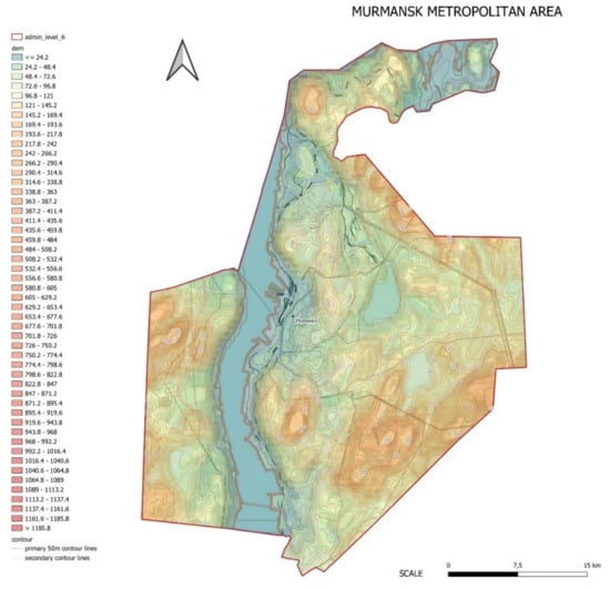
Figure 1.
Russian Arctic residential area located on a slope.
The goal of the study was to estimate the effect of the slope aspects on the windchill index in order to determine the percentage of AZFR areas suitable for residential development due to providing psychophysical health benefits and a sense of human comfort.
The initial data were based on analyses of the slope aspects of the area in question (slope exposure and slope gradient). The Murmansk region has a varied landscape: mountains and plains, swampy lowlands, and numerous lakes and rivers. The Kola Peninsula occupies a little less than 70% of the area of the Murmansk region. The western part of the peninsula is covered by two main mountain ranges within the Arctic Circle: the Khibiny Mountains and the Lovozero Massif; the former contains the highest point of the Kola Peninsula. The Murmansk region is located in the Atlantic-Arctic zone. It predominately has a temperate climate, which entails a subarctic marine climate in the northern part and a cold temperate climate in the southern part. The influence of Barents Sea, which enhances the influence of the warm North Atlantic Current, makes the climate of the Murmansk region quite different from other towns located above the Arctic Circle, with lower temperatures otherwise typical to the central parts of the Kola Peninsula. Weather conditions are characterized by sharp changes and instability due to frequent changes in the air masses direction. Wind in the Murmansk region has a monsoonal character—south and southwesterly winds prevail in winter months bringing dry frosty weather and north and east winds bring the increased humidity of air in summer months. Strong storm winds blow for 80–120 days a year; the average wind speed on the Murmansk coast reaches 8 m per second and up to 5 m per second in the Kola Peninsula. A minimum temperature of −39.4 °C was recorded in Murmansk on 6 January 1985 and on 27 January 1999, while a maximum temperature of +32.9 °C was recorded on 9 July 1972. Polar night at Murmansk’s latitude lasts from 2 December to 11 January, while polar day lasts from 22 May to 22 July.
Considering the orientation of the slope surface, four main variations of slope exposure were chosen for study: northern, southern, western, and eastern variations. The analysis of slope elevation enabled us to define the value of slope gradient for the location of residential buildings from 0.5% to 19%.
The wind speed and the average temperature of the winter season (as the most uncomfortable one) were chosen as the main climatic parameters necessary to determine the area of uncomfortable zones. The windchill temperature index was used as the indicator of human body discomfort. The choice of the windchill index parameter was based on its wide range of applications in the United States, Canada and other countries located in cold regions while planning and making decisions, as it is considered an effective parameter to express the relationship between the lack of human physiological comfort and the common effect of wind and temperature climatic factors.
Although this index does not take into account environmental factors such as the relative humidity of weather and sun radiation, Osczevski and other researchers that focus on this index believe that considering wind speed and ambient temperature is enough to make this index sufficient in order to protect human health in cold weather [33]. Of course, the feeling of temperature by a body depends on the humidity; however, most of the settlements where the wind-chill values are required are located in continental climate zones with cold dry winters where the influence of air humidity can be neglected.
The relative weather humidity should be taken into consideration when the apparent temperature is higher than the air temperature. In such cases, the humidity index (Humidex) is used instead. It takes into account the weather factors of temperature and humidity and is used by meteorologists during summer months and in hot countries.
In polar regions, dry and cold winds prevail throughout the year while snow and ice surface reflect back most all of the visible sun light, meaning air temperature and relative humidity are low. The annual amount of precipitation in the subarctic belt is up to 600 mm, which reflects the maximum falls in summer. The main characteristics of the local climate for winter period are shown in Table 1.

Table 1.
Main climatic characteristics for winter period in the Murmansk metropolitan area. (source: Construction Climatology, SP 131.13330.2018).
The average parameters of the most uncomfortable winter season were taken as natural factors for defining the uncomfortable zones of residential development in the Russian Arctic. They are determined through the graphs of the complex effects of temperature and wind on buildings and humans developed by Ratner. They allow comparing the average temperature and wind speed of the coldest period (for the settlements of the Russian Arctic, the winter period) and determine the wind speed at which a person’s condition can be considered uncomfortable [14,15,16]. Data on the gradient and orientation of the slope, as well as parameters from the group of urban planning factors, can be obtained from any open geographic information systems.
According to the data in Table 1, the average air temperature in the non-comfortable winter period is −18.6 °C and the average wind speed in the uncomfortable winter period is 3.3 m/s. These data were obtained from open sources of Murmansk weather stations.
The second research factor is the type of building. After analyzing the residential building in Murmansk, a residential perimeter block was identified as the main residential block plan. The history of urban development of these territories dates back to the 1960s–1980s, when the urban planning concept was built on the concept of residential microdistricts, which in their turn comprised several residential complexes—multi-story block apartments.
Analysis of the building morphology in the largest cities of the Russian Arctic has shown that perimeter building is also one of the most widespread morphologies on the slope territories that are justified primarily by their excellent wind protection characteristics. However, the aeration regime of buildings on sloping areas significantly differs from the aeration regime of the same buildings on flat terrain. Using the similar planning techniques reduces the quality and safety of the urban environment, increases the risk of air pollution, and deteriorates the appearance of the city and human comfort of the inhabitants.
The hypothesis of this study was that estimation of the slope aspect affects the wind-chill index, allows determining the percentage of AZFR areas suitable for residential development, and provides psychophysical health benefits and a sense of human comfort for the most common type of residential perimeter block pattern.
3. Research Methods
To prove the hypothesis, a theoretical task was to investigate how the gradient and orientation of the slope influence the wind regime on the construction sloping lands. The obtained results were justified through the following urban planning project of residential areas located in the Russian Arctic.
The results of the integrated assessment proved their scientific and practical significance by highlighting the regularity of formation of the slope aeration regime from the gradient and exposure of the slope. They also might be helpful in developing specific recommendations for the placing and design of residential areas on Russian Arctic slope lands.
The research methods were aimed at determining the percentage of comfortable areas based on the ratio of the aeration regime and slope parameters, the existing data on the Arctic region, and the specifics of the implementation of urban planning activities. To obtain useful results, we developed the following methodological fluxogram of the research (Figure 2).
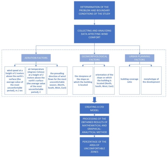
Figure 2.
Methodological fluxogram of the research.
The algorithm for studying the aeration regime of a residential area on the slopes in the AZRF begins with defining the problem and boundary conditions of the study. Next comes the collection and analysis of data that affect wind comfort.
In the case of determining the uncomfortable zones of residential development on the slopes of the AZRF, we considered three groups of factors affecting wind comfort of the buildings on slope territories. The group of aeration factors is represented by the speed, temperature, and direction of the wind. The group of geomorphological factors is represented by orientation and gradient of the slope. The density and the residential block plan pattern represent the group of urban planning factors, such as the building coverage ratio and morphotype of the development.
Experimental study and wind flow simulation were carried out using the ANSYS Fluent software. The ANSYS Fluent software module has a wide range of possibilities for modeling the flows of liquids and gases and is suitable for studying the aerodynamic regime of the slopes. The studies made by Blocken, Janssen, and Van Hooff have proved that CFD-modeling is one of the most precise instruments to assess pedestrian wind comfort and wind security in urban regions [31]. The input speed for mathematical modeling of wind flows is the average speed of the winter period in the Murmansk region: –3.3 m/s.
Comparison of the results of the numerical calculation of the values of wind speeds and their comparison with the results obtained from using the ANSYS Fluent software package for assessing the aeration regime of the territories under study allowed us to identify the configurations of planning schemes that provide wind comfort. The results achieved from CFD analyses were processed using the mathematical and graphical-analytical method. When applying the speed gradation scale which is displayed when rendering results in ANSYS Fluent, it was necessary to calculate the areas of zones where the speed is equal to or greater than that defined in the study area as uncomfortable. Further, the results needed to be entered into the tables and be used to calculate the percentage of the areas of uncomfortable zones relative to the entire area of the adjacent territory using the methods of mathematical analysis.
This research algorithm was applied for theoretical research in which the boundary conditions data will be used for aeration, geomorphological, and urban planning factors in the range typical for the region (the Murmansk region) described in the study area. The theoretical study must be verified in a control experiment, where CFD modeling with further processing of the obtained results of mathematical and graphical-analytical method is carried out on a specific real site within the considered boundaries of the study.
The percentage of the area of uncomfortable zones was the result of the theoretical and control experiment. Dependency graphs of the area of uncomfortable zones on the slope parameters obtained in the theoretical study should be taken into consideration while determining the percentage of the area of comfort zones of the projected development, and also to adjust design solutions by choosing the most comfortable slope exposure for a given prevailing wind direction. Based on the obtained ratio of the aeration regime and slope parameters, it is possible to design housing on slopes in the Russian Arctic comfortable for the psychological and physical state of a person.
4. Theoretical Study Using CFD Analysis
Theoretical research requires first collecting and analyzing data affecting wind comfort—Aeration, geomorphologic, and urban planning parameters as well as a building coverage ratio and area plan morphotype, for theoretical model. The main optimization parameter that was used to assess the planning configuration of a residential zone is the percentage of the area of the uncomfortable zone that was determined as the result of theoretical study using CFD analysis. The analysis of the climatic conditions of the Murmansk metro area enabled describing the main values of the initial data for further assessment of residential wind comfort (Figure 3).
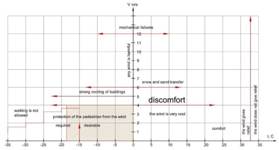
Figure 3.
Climatic conditions for population for an average winter temperature of −18 °C in the Murmansk metropolitan area.
Thus, the threshold value of the wind speed compatible with wind comfort inside residential area was described as V = 4 m/s. The research methodology was based on system analysis to perform a complex investigation, which includes research of theoretical and statistical background, experimental design and modeling, and comparative analysis of the results of a numerical and physical experiment.
The design experiment for the residential perimeter block pattern development was carried out for 4 slope exposures and for 12 different slope elevation gradients. In total, 48 models were analyzed. The slopes used for theoretical study of the Murmansk residential areas are defined in a study area and vary in the rage from 0.5% to 19%.
To conduct the experiment, we identified the most representative initial data. A residential perimeter block was chosen for the experiment because it is the most significant and typical pattern of residential planning in the Murmansk region (Figure 4). Considering local climatic conditions, we chose the southwest wind direction, which is the most unfavorable and predominant direction in the coldest winter months.
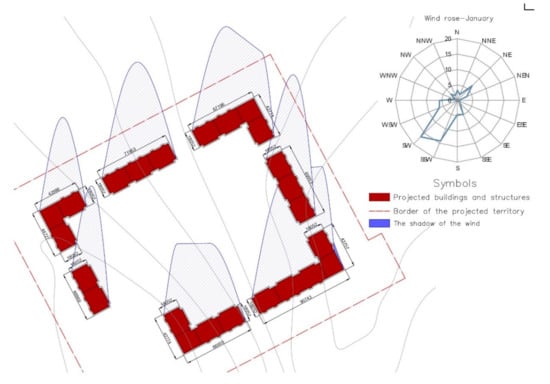
Figure 4.
Typical residential perimeter block pattern and the wind rose for the Murmansk metropolitan area.
For the study, a residential area was designed with certain absolute and relative parameters of area, population density, and land use, which represent the averaged data obtained from the analysis of existing residential perimeter block pattern in Murmansk. The parameters of the designed residential area are presented in Table 2.
Table 2.
Main average urban parameters of a typical residential area.
After obtaining the main parameters, CFD modeling was carried out. Figure 5 presents visual processing of the experimental data obtained using ANSYS Fluent software as velocity fields for various combinations of gradient and exposure of the slopes under the most uncomfortable prevailing southwestern wind direction. The speed scale shown in Figure 6 was used in the assessment. The speed scale indicates the speeds obtained because of changes in the direction, pressure, and speed of the wind. In the fields of velocities, the speed gradation is shown by the gradation of colors (Figure 6). The focus is on the adjoining space, which hosts are the main socially significant components of beautification—playgrounds, sports grounds, and places of quiet recreation.
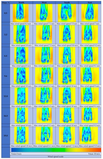
Figure 5.
Velocity fields under average temperature of −18 °C and wind velocity of 4 m/s for various combinations of slopes gradient and exposure.
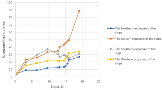
Figure 6.
Relationship between gradient, exposure, and percentage of uncomfortable areas.
The processing of the results of CFD modeling was carried out using the mathematical and graphical-analytical method. Based on the results of CFD modeling visualization, we calculated the total percentage of uncomfortable areas for each of the four slope exposures according to the 7 types of slopes defined in the study area. Table 3 shows the proportion of uncomfortable areas in the total area of each model.
Table 3.
The proportion of uncomfortable areas under average temperature of −18 °C in the total area of each model.
Studies have shown that within the range 13.2 to 19%, the change in the velocity fields is insignificant. Thus, the final matrices for determining the uncomfortable areas were made for slope values of 0.5%, 3.2%, 6.4%, 9.6%, 12.8%, and 19%.
Colored areas from yellow to red indicate the presence, distribution, and shape of uncomfortable areas within a residential perimeter block, where the average wind speed exceeds 4 m/s (Figure 4). The data obtained allows production of graphics showing a relationship between the slope gradient and exposure and the percentage of uncomfortable area in the total space within the perimeter of a residential block. As a result of theoretical modeling, the minimum percentage of uncomfortable zones on the area plan was found to be 3.6% of the total area of the residential zone occupied by public territories.
Figure 6 shows the diagrams of the distribution of the values of uncomfortable areas of various combinations of exposures and gradients.
The results obtained indicate that the increase of the slope elevation at any exposure of the slope increases the percentage of uncomfortable areas.
The north and east exposures are the most comfortable when facing the south-west wind, since the building in this case is located on the leeward side. In this case, the relief even contributes to the protection from the wind.
The largest model of uncomfortable areas (more than 21% of the total area of the yard space, and the wind acceleration reaches 7 m/s) observed a slope of 6.4% with a southern orientation of the slope at the entrance to the courtyard between the houses (Figure 4). However, in the same area, with an increase in the slope, the area of the uncomfortable zone significantly decreased. For example, at 19%, the area of this uncomfortable area decreases to 9%, and the maximum acceleration reaches 5.7 m/s. This effect is associated with the forced terracing of buildings on such a steep slope. A decrease in flow rate at the construction of terraces has been proven by various studies, for example in the research of Johansson and Yahia [20].
5. Control Experiment
The territory of the residential area in the north of the city of Murmansk was chosen for a control experiment in order to check the applicability of the obtained research results. The development in question was located on Heroes Rybachy Street in the Severnoye Nagornoye microregion (Figure 7).
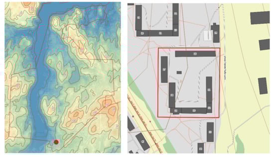
Figure 7.
Situational plan of the area under consideration, indicating the contours of the relief.
For the study, a site was taken with the same residential block plan pattern and density as in the theoretical study. The site is a perimeter building and has a western exposure and the slope is 13.6% (Figure 8). Climatic parameters are the same as for theoretical research: the average winter temperature in Murmansk is −18 °C which at a wind speed of 4 m/s or more will be uncomfortable for residents.
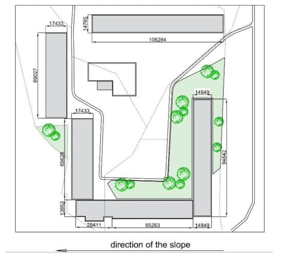
Figure 8.
Real residential perimeter block in Murmansk city.
A space-planning solution of buildings is presented in the form of multilevel sections going down the slope on which the quarter is located. A three-dimensional image of the quarter under consideration is shown in Figure 9.
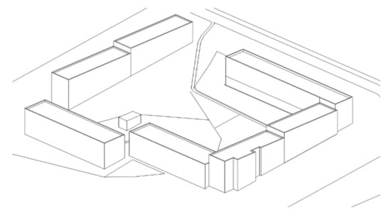
Figure 9.
Three-dimensional image of the real residential perimeter block in Murmansk city.
The main urban planning parameters of the selected building—the total square of residential built-up area, total area of buildings on the residential area, and building coverage ratio—were found to correspond to the theoretical study. All parameters of the selected residential building are presented in Table 4.
Table 4.
The main parameters of the territory for the control experiment.
For the control experiment, CFD modeling was also carried out in the ANSYS Fluent program. The goal of the experiment was to determine the percentage of the area of uncomfortable zones and compare the results with the values obtained in a theoretical study on a slope with the same slope and the same exposure.
The uncomfortable zones were counted using the graphical and analytical method. The speed similar to the theoretical study (V = 3.3 m/s) was chosen as the input speed.
As a result of a control experiment using CFD modeling, the following results were obtained using the mathematical and graphical-analytical method. Uncomfortable zones where the average wind speed is more than 4 m/s occupy 32% of the courtyard area of the considered building, and maximum wind speed reaches 8.1 m/s (Figure 10). Indicators correspond to the diagrams of the distribution of the discomfort areas values at different exposure and gradient combinations. Theoretical study results for analogous western exposure and a slope of 12.8% show a 34.7% uncomfortable area rate. The control experiment showed that the graphs of the relationship between the discomfort areas and the gradient of the slope can be used to choose the optimal slope exposure of the slope when placing residential buildings on slope territories.
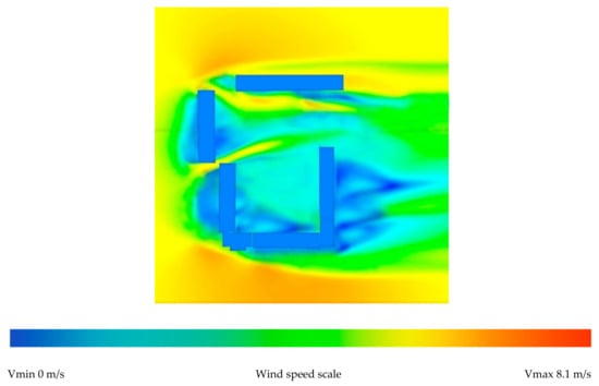
Figure 10.
Velocity fields for the real residential perimeter block in Murmansk city.
6. Discussion
Krogius et al. [3] dealt with the issues of urban development of slope territories. These authors carried out an extensive study of the planning structure of cities on slope areas. However, not all structures are suitable for low temperature applications. Studies of urban development of the territories of the Russian Arctic, for example by Shvedov and Yakimov [4], discuss important problems consisting mainly of the absence of specific guidelines for the improvement of the urban environment of the Russian Arctic; however, the question of the relationship between the spatial planning solutions of residential buildings and wind comfort on slope areas remains open. The accepted values of the slope limits and the limits of the uncomfortable wind speeds were determined from the geomorphological and climatic analysis of the Murmansk region according to the theory of Ratner’s research [14,15].
Now, there are scientific developments in the field of the influence of slope morphology on aeration. For example, the studies of Serebrovsky [7], Olenkov [8], and Chernykh [12] deal with the problem of slope territories aeration; however, a theoretical knowledge about changing the aeration regime during urban development of these territories is still absent. In general, taking into account local climatic data is one of the most important factors in the sustainable development of the territory, according to the researchers Myagkov et al. [38].
It is also important to note that the Russian Local Urban Planning Standard does not have enough information on the topic of aeration comfort. This study is aimed at strengthening the regulatory framework for urban planning in the sloping territories of the Russian Arctic without losing aeration comfort.
The correlation graphics obtained in course of the experiment demonstrate that the percentage of uncomfortable area within a residential perimeter block always increases with the increase of a slope gradient.
The experiment proved that when a gradient is more than 8.74%, multi-level multiple section residences should be constructed, as they that do not affect the speed of the wind flow and offer a smart space planning solution.
When the gradient is more than 14.05–15.9%, the airflow comes out from the surface, generating vortex flows and contributing to a significant increase in the uncomfortable areas percentage. Therefore, such slope gradients are considered as the most discomfortable and difficult ones for construction.
The best slopes for the placement of residential perimeter blocks are 3.4–15%, on the downwind side, since under such slope aspects, the growth in the proportion of uncomfortable areas is relatively small.
With the prevailing southwest wind direction, north-facing slopes will be at an advantage, since the area of uncomfortable zones is not greater than 27%.
Therefore, according to the result of the experiment, the slope territories of Russian Arctic are quite suitable for built social environments without specific wind-resistant measures. The most favorable slope for urban improvement is 3.4–15%.
The choice of spatial planning solutions for residential buildings, taking into account the wind regime, has been studied by many researchers, for example, Limona et al. [22]. They have investigated the issue of choosing planning solutions while taking into account wind comfort, but for hot countries, also applying the Humidex index. The choice of spatial and planning solutions for residential buildings, taking into account the wind regime on slope territories in the Russian Arctic, is still studied insufficiently.
This study considered the question of placement of the most effective perimeter buildings in terms of wind protection on the slopes of the Russian Arctic. The residential perimeter block pattern remains a valid model, including from the perspective of wind comfort. At any slope, the most favorable areas are the zones in the center of the perimeter block and in the corner of the yard. The most uncomfortable conditions are observed in yard entry zones. Such places are suggested to be optimum locations for parking lots or windproof green spaces.
The study has demonstrated the effectiveness of using CFD modeling to determine the area of comfortable and uncomfortable residential areas on the slope territories of the Russian Arctic. The research of Valger [34] and Fedorova [35] state that the use of numerical methods for modeling wind flow in architectural design allows us to choose the best layout of and optimal spatial form of the construction objects. In addition, modeling various scenarios for the arrangement of small architectural forms and green areas allows the architect to propose new solutions on the management and change of the wind regime of the territory with an already existing building.
Reducing the percentage of the area of uncomfortable zones is possible due to additional landscaping in places with wind acceleration (openings between houses, space along buildings located in the direction of unfavorable wind). Much research confirms a significant reduction of the uncomfortable areas when using additional landscaping, windproof structures, and methods of geoplastics. For example, a study by Johansson and Yahia [20] demonstrates a significant decrease in wind speed due to terracing of the embankment compared to the flat surface. In addition, the issue of placing wind protection structures was highlighted in the study by Dolzhenkova and Kalashnikov [23], where several types of forest plantations and wind protection structures were considered and where they determined the most effective method for choking the air flow in various conditions. It is also worth noting that windproof structures can be multifunctional. For example, with the correct perforated structure, small architectural forms can perform not only a recreational, decorative, or play function, but also a windproof one.
7. Conclusions
The Arctic offers harsh climatic conditions for its inhabitants. However, a careful scientific approach to the design of a built environment with full consideration of local climatic and relief characteristics allows for ensuring wind comfort inside residential zones located on slope lands of the Russian Arctic by providing an aeration regime when the area of uncomfortable zones will not exceed 3.6%.
The analysis of existing residential perimeter block pattern in Murmansk demonstrated that the wind comfort of residential space is strongly influenced by the wind speed. Investigation of the relationship between the local wind regime, slope aspects, and residential comfort allowed for determining conditions for urban planning at AZFR Murmansk metro area slope lands, which could be expected to provide comfortable wind environment for the residence population and plot the graphics of relationship between slope aspects and the percentage of uncomfortable area considering the influence of southwest wind direction (the most unfavorable prevails in winter).
The graphics developed in the result of the research can be used by architects and city planners at the stage of decision making for project design, when choosing the optimal form of residential building for the given exposure and gradient of the Arctic. Such preliminary consideration of every aspect of the natural environment will help to obtain optimal rates of aeration comfort of the building environment and reduce future costs for wind protection.
The main useful results of this study determine basic conditions when choosing such areas for residential development on the slope territories within the boundaries of AZFR that are suitable for providing wind comfort.
The results obtained have scientific and practical novelty for the sustainable provision of the increase of urban settlements through increasing population growth and improving living standards in harsh climatic conditions.
Author Contributions
Conceptualization, N.D.; methodology, N.D.; software, A.K.; validation, A.K. and N.D.; formal analysis, N.D. and N.M.; writing—original draft preparation, A.K.; writing—review and editing, N.M.; supervision, N.D. All authors have read and agreed to the published version of the manuscript.
Funding
This research received no external funding.
Institutional Review Board Statement
Not applicable.
Informed Consent Statement
Not applicable.
Data Availability Statement
All data and codes used in this study are available by requesting the authors (danilinand@mgsu.ru; makishana@mgsu.ru).
Conflicts of Interest
The authors declare no conflict of interest.
References
- Putintsev, E.P. Integrated Concept of Northern Urban Development: Northern Urban Development in the First Climatic Region; Publisher: Moscow, Russia, 2005. [Google Scholar]
- Putintsev, E.P. An Integrated Concept of Nordic Urban Planning; Stroiizdat: Moscow, Russia, 2005. [Google Scholar]
- Krogius, V.R.; Ehbbot, D.; Pollit, K. Urban Planning on the Slopes; Stroiizdat: Moscow, Russia, 1988. [Google Scholar]
- Shvedov, V.V.; Yakimov, A.A. Improvement of the territory of the municipality in the Far North. Hum. Sci. Res. 2015, 11, 409–414. [Google Scholar]
- Gainanov, D.A.; Kirillova, S.A.; Kuznetsova, Y.A. The Russian Arctic in the context of sustainable development. Econ. Soc. Chang. Facts trends Forecast 2013, 6, 68–77. [Google Scholar]
- Kolbin, D.S.; Olenkov, V.D. A study of the wind regime with the aim of aeration and windbreaks urban areas. Bull. Perm Natl. Res. Polytech. Univ. Constr. Archit. 2011, 1, 36–39. [Google Scholar]
- Chernykh, D.V. Landscape basis for the formation and optimization of the territorial organization of environmental management in the mountains (on the example of mountains of southern Siberia). News Altai Branch Russ. Geogr. Soc. 2016, 2, 11–20. [Google Scholar]
- Olenkov, V.D. A study of wind conditions in the disturbed areas. Bull. SUSU Ser. Constr. Eng. Archit. 2014, 14, 9–13. [Google Scholar]
- Olenkov, V.D. Calculation of the Aeration Mode of Disrupted Areas. Bull. SUSU Ser. Constr. Eng. Archit. 2017, 17, 13–19. [Google Scholar]
- Lazareva, I.V.; Olenkov, V.D. Urban Development of the Disrupted Areas. Urban Plan. 2012, 3, 34–43. [Google Scholar]
- Guidelines for the Assessment and Regulation of the Wind Regime of Residential Buildings; TSNIIP of Urban Planning: Moscow, Russia, 1986.
- Cerebrovskii, F.L. Aeration of Populated Areas; Stroiizdat: Moscow, Russia, 1985. [Google Scholar]
- Retter, E.I. Architectural and Construction Aerodynamics; Stroiizdat: Moscow, Russia, 1984. [Google Scholar]
- Ratner, E.M. Method of physiological assessment of the local climate by its impact on the thermal state of a person. Issues Cult. Stud. 1967, 5, 446–451. [Google Scholar]
- Kandror, I.S.; Demina, D.M.; Ratner, E.M. Human Thermal State as the Basis of Sanitary and Climatic Zoning of the Territory of the USSR; The Medicine: Moscow, Russia, 1974. [Google Scholar]
- Kandror, I.S.; Demina, D.M.; Ratner, E.M. Physiological Principles of Sanitary and Climatic Zoning of the Territory of the USSR; The Medicine: Moscow, Russia, 1974. [Google Scholar]
- Quayle, R.G.; Steadman, R.G. The Steadman wind chill: An improvement over present scales. Weather Forecast. 1998, 13, 1187–1193. [Google Scholar] [CrossRef]
- Osczevski, R.; Bluestein, M. The new wind chill equivalent temperature chart. Bull. Am. Meteorol. Soc. 2005, 86, 1453–1458. [Google Scholar] [CrossRef]
- Osczevski, R.J. The basis of wind chill. Arctic 1995, 48, 372–382. [Google Scholar] [CrossRef]
- Johansson, E.; Yahia, M.W. Wind comfort and solar access in a coastal development in Malmö, Sweden. Urban Clim. 2020, 33, 2–14. [Google Scholar] [CrossRef]
- Ghasemi, Z.; Esfahani, M.A.; Bisadi, M. Promotion of urban environment by consideration of human thermal & wind comfort: A literature review. Procedia-Soc. Behav. Sci. 2015, 201, 397–408. [Google Scholar]
- Limona, S.S.; Al-Hagla, K.S.; El-Sayad, Z.T. Using simulation methods to investigate the impact of urban form on human comfort. Case study: Coast of Baltim, North Coast, Egypt. Alex. Eng. J. 2019, 58, 273–282. [Google Scholar] [CrossRef]
- Dolzhenkova, E.I.; Kalashnikov, D.V. Modeling of windproof structures. Bull. Landsc. Archit. 2015, 5, 32–36. [Google Scholar]
- Toparlar, Y.; Blocken, B.; Vos, P.V.; Van Heijst, G.J.F.; Janssen, W.D.; van Hooff, T.; Timmermans, H.J.P. CFD simulation and validation of urban microclimate: A case study for Bergpolder Zuid, Rotterdam. Build. Environ. 2015, 83, 79–90. [Google Scholar] [CrossRef]
- Ricci, A.; Kalkman, I.M.; Blocken, B.; Repetto, M.P.; Burlando, M.; Freda, A. Local-scale forcing effects on wind flows in an urban environment. In Proceedings of the International Workshop on Physical Modeling of Flow and Dispersion Phenomena, Zürich, Switzerland, 7–9 September 2015; pp. 1–6. [Google Scholar]
- Blocken, B.; Carmeliet, J.; Stathopoulos, T. CFD evaluation of wind speed conditions in passages between parallel buildings—Effect of wall-function roughness modifications for the atmospheric boundary layer flow. J. Wind Eng. Ind. Aerodyn. 2007, 95, 941–962. [Google Scholar] [CrossRef]
- Blocken, B. Computational Fluid Dynamics for urban physics: Importance, scales, possibilities, limitations and ten tips and tricks towards accurate and reliable simulations. Build. Environ. 2015, 91, 219–245. [Google Scholar] [CrossRef]
- Toparlar, Y.; Blocken, B.; Maiheu, B.; Van Heijst, G.J.F. A review on the CFD analysis of urban microclimate. Renew. Sustain. Energy Rev. 2017, 80, 1613–1640. [Google Scholar] [CrossRef]
- Blocken, B.; Stathopoulos, T.; Van Beeck, J.P.A.J. Pedestrian-level wind conditions around buildings: Review of wind-tunnel and CFD techniques and their accuracy for wind comfort assessment. Build. Environ. 2016, 100, 50–81. [Google Scholar] [CrossRef]
- Ramponi, R.; Blocken, B.; Laura, B.; Janssen, W.D. CFD simulation of outdoor ventilation of generic urban configurations with different urban densities and equal and unequal street widths. Build. Environ. 2015, 92, 152–166. [Google Scholar] [CrossRef]
- Blocken, B.; Janssen, W.D.; van Hooff, T. CFD simulation for pedestrian wind comfort and wind safety in urban areas: General decision framework and case study for the Eindhoven University campus. Environ. Model. Softw. 2012, 30, 15–34. [Google Scholar] [CrossRef]
- Basok, B.I.; Davydenko, B.V.; Novikov, V.G. Numerical simulation of wind flows in the urban development zone. Renew. Energy 2014, 2, 46–59. [Google Scholar]
- Hu, K.; Cheng, S.; Qian, Y. CFD Simulation Analysis of Building Density on Residential Wind Environment. J. Eng. Sci. Technol. Rev. 2018, 11, 35–43. [Google Scholar] [CrossRef]
- Valger, S.A.; Fedorova, N.N. CFD Methods in Architecture and City Planning. J. Phys. Conf. Ser. 2019, 1425, 121–124. [Google Scholar] [CrossRef]
- Valger, S.A.; Fedorov, A.V.; Fedorova, N. Numerical study of the flow around buildings by turbulent air flow in the ANSYS Fluent PC. Comput. Technol. 2013, 18, 101–112. [Google Scholar]
- Fedorova, N.N.; Valger, S.A.; Zakharova, Y.V. Modeling of Hydro-Gas-Dynamic Processes in PC ANSYS 17.0; Novosibirsk State University of Architecture and Civil Engineering: Novosibirsk Oblast, Russia, 2016. [Google Scholar]
- Fadl, M.S.; Karadelis, J.N. CFD simulation for wind comfort and safety in urban area: A case study of Coventry university central campus. Int. J. Archit. Eng. Constr. 2013, 2, 131–143. [Google Scholar] [CrossRef]
- Myagkov, M.S.; Gubernskiy, Y.D.; Konova, L.I.; Litskevich, V.K. Town, Architecture, People and Climate; Architecture-S: Moscow, Russia, 2007; pp. 77–80. [Google Scholar]
Publisher’s Note: MDPI stays neutral with regard to jurisdictional claims in published maps and institutional affiliations. |
© 2021 by the authors. Licensee MDPI, Basel, Switzerland. This article is an open access article distributed under the terms and conditions of the Creative Commons Attribution (CC BY) license (http://creativecommons.org/licenses/by/4.0/).