
Defining the Peri-Urban: A Multidimensional Characterization of Spatio-Temporal Land Use along an Urban–Rural Gradient in Dar es Salaam, Tanzania


1
Geography Department, Humboldt-Universität zu Berlin, 10099 Berlin, Germany
2
School of Spatial Planning and Social Sciences, Ardhi University Dar es Salaam, Dar es Salaam 35176, Tanzania
3
Integrative Research Institute on Transformations of Human-Environment Systems (IRI Thesys), 10099 Berlin, Germany
*
Author to whom correspondence should be addressed.
Land 2021, 10(2), 177; https://doi.org/10.3390/land10020177
Submission received: 22 December 2020
/
Revised: 2 February 2021
/
Accepted: 4 February 2021
/
Published: 9 February 2021
(This article belongs to the Special Issue Rural–Urban Gradients: Landscape and Nature Conservation)
Abstract
:Highly dynamic peri-urban areas, particularly in the Global South, face many challenges including a lack of infrastructure, ownership conflicts, land degradation, and sustainable food production. This study aims to assess spatial land use characteristics and processes in peri-urban areas using the case of Dar es Salaam, Tanzania. A mixed-method approach was applied, consisting of expert interviews and spatial data analysis, on a local scale along an urban–rural gradient. Expert interviews were conducted during a field study and analyzed regarding the characteristics and processes of peri-urban land development. A GIS-based analysis of land use patterns was applied using satellite imagery and Open Street Map data to identify a number of variables, such as building density and proximity to environmental features. Results show specific patterns of land use indicators, which can be decreasing (e.g., house density), increasing (e.g., tree coverage), static (e.g., house size), or randomly distributed (e.g., distance to river), along a peri-urban gradient. Key findings identify lack of service structures and access to public transport as major challenges for the population of peri-urban areas. The combination of qualitative expert interviews and metrics-based quantitative spatial pattern analysis contributes to improved understanding of the patterns and processes in peri-urban land use changes.

1. Introduction
With increasing urbanization and over half of the world’s population living in cities, urban areas and their inhabitants face many challenges, including socio-economic and ecological changes [1]. Urban growth spreading into peri-urban areas is a key driver of unsustainable development [2], and in Sub-Saharan Africa, local and regional governments face difficulties in monitoring and addressing urban expansion. Significant demographic pressure is expected in Dar es Salaam, for example, where approximately 226,000 new urban dwellers are expected annually [1]. Dar es Salaam has exceeded Nairobi as Eastern Africa’s largest city. Urban food security is critical and contributes to the increasing pressure on peri-urban areas that are important for urban food provision and undergo the transition from agricultural lands into residential areas [3,4]. In the less-developed world, urbanization surpasses all other uses for land adjacent to the city, including prime croplands [5].
The ways in which nations define what is urban and what is rural can vary significantly; the boundaries of urban settlements are not as clearly defined as the administrative delimitations [6]. Doan and Oduro [7] introduced the village magnet hypothesis, whereby peri-urban development appears to be attracted to pre-existing villages that already have basic levels of critical services. Hence, they often become the nuclei of fast-growing, densely populated pockets. However, Dar es Salaam has also developed along highways and major roads, as per the Ribbon hypothesis [7]. Peri-urban areas are lacking a precise definition and a comprehensive approach or framework: the terminology remains vague with a variety of definitions (e.g., urban–rural interface, fringe, continuum, periphery, outskirts, hinterland, edgelands) [8,9,10,11,12,13]. Some studies describe the peri-urban as a type of land use or a land use dynamic, functioning as a “divide” between city and countryside (the urban fringe theory) [8,14]. Others refer to it as the dynamic and fast transformation of rural land into urban land (the sprawl approach) [15,16]. According to Ravetz et al. [17], peri-urban areas are often understood to be mixed areas under an urban influence but with a rural morphology from a European perspective, whereby in the Global South, the “peri-urban interface” relates to newly urbanized zones at the fringes of cities. In light of enhancing sustainable development of (urban) areas, peri-urban zones play a critical role at a global level [18]. Due to the complex characteristics of peri-urban areas, studies have addressed multiple dimensions of spatial change, mobility, identity, and economic activities [19,20]. Approaches describing and defining the urban–rural interface range from focusing on morphology and land use characteristics to socio-economic or cultural transitions [9,20,21,22]. Although the dynamics and characteristics of peri-urban areas and processes might be regionally specific [23,24], conceptual models of patterns and dynamic trends can be applied independently from regional specifics. Globally, a substantial amount of studies particularly trends to incorporating spatial metrics and analysis to develop such concepts [25,26,27,28]. However, the understanding and conceptualization of processes in studies with, e.g., European focus have usually limited transferability to regions of the GS [23].
The inherent complexity of the peri-urban areas puts the traditional duality of rural vs. urban areas in question [29]. Laband et al. [9] emphasize that the urban–rural dichotomy is still deeply embedded in the field and suggests a more open discussion and the eventual adoption of a continuum or gradient approach. Pryor [30] previously described the peri-urban as a landscape phenomenon, in which the fringe varies between cities and over time. The peri-urban is mainly characterized as a hybrid transitional zone, combining urban and rural conditions [31], forming a new type of multi-functional territory [2].
According to Nilsson [2], there are common features wherever peri-urban areas are found, such as a relatively low population density (by urban standards), scattered settlements, high dependence on transport for commuting, fragmented communities, and lack of spatial governance. Particularly in the context of Africa, studies often refer to the importance of urban fringe agriculture and rural linkages [9,31]. According to Chirisa et al. [32], the problem of conceptualizing the peri-urban interface has been implicit in development policy studies in developing countries for several decades. More recently, attention has been focused on the emergence of formal and informal land markets and the related land-use changes in peri-urban areas [29]. Studies with spatial reference to Dar es Salaam mainly focus on urban expansion along the urban–rural gradient, in relation to agriculture, transport, and policies [33,34,35,36,37,38,39].
Although the majority of peri-urban research has focused on the global North (Europe and North America), Nilsson et al. [2] has emphasized the arising global challenges of peri-urbanization, particularly in the Global South (GS). A number of studies have investigated the land use dynamics of African cities and peri-urban regions [3,4,24,36,40], as well as the challenges posed by rapid urbanization, particularly food insecurity or land degradation [41] and the spatial patterns of informal growth and interdependencies of city centers and peri-urban settlements [36]. However, there is a lack of information on the characteristics of the spatio-temporal processes of the peri-urban: these data are urgently needed for an improved understanding, particularly for cities in the GS [42].
Previous studies have included spatial indicators, such as land cover, access to public transport, road density, distance to roads, building density, or travel time [3,6,39,43]. Developing strategies to understand and monitor these changes are also in line with the Sustainable Development Goals [44]. The city of Dar es Salaam in Tanzania is committed to the development of sustainable cities and communities under the Sustainable Development Goals. The need for ongoing research for understanding characteristics and processes, in combination with analyzing land use change, is crucial in peri-urban areas, particularly in the GS, where population numbers and urbanization is rapidly increasing. This rapid population growth drives urban expansion, with unregulated development leading to challenges in regulation, control, and monitoring.
The aim of this study is to characterize the patterns and underlying processes of the spatio-temporal dynamics of the peri-urban area in the GS. We identify and analyses indicators using a gradient approach in order to answer the following questions: (1) What are spatio-temporal characteristics and patterns of peri-urban areas? (2) How can dynamics along a peri-urban gradient be generalized and conceptualized? While we show the processes along a case-study specific peri-urban gradient, the methodology and conceptual conclusions may be transferred to other regions. The case of Dar es Salaam is investigated, with the focus on a peri-urban gradient in the Msongola ward. An urban–rural gradient was chosen that includes the former peri-urban and more urbanized areas, as well as sparsely populated areas within the Dar es Salaam region representing different stages of peri-urbanization with heterogeneous spatial and temporal dynamics.
We followed a workflow of combining qualitative and quantitative approaches. In particular, we conducted expert interviews to explore characteristics and processes within the peri-urban followed by spatial pattern analysis of a selected set of characteristics quantified through indicators including socio-economic and environmental indicators. Finally, we propose trends of dynamics to generalize peri-urban characteristics and processes.
2. Methodology
2.1. Study Area
Dar es Salaam was selected for this study because it is one of the most rapidly growing East African cities, with a population of 4,364,541 in 2012 (last census) to projected 5,017,294 in 2017 [45,46]. The city is located on the eastern side of Africa, bordered by the Indian Ocean (Figure 1). Since its independence (1961), Dar es Salaam has been the dominant business and industrial center of Tanzania [38]. It has a radial structure and grows outwards following the main infrastructure lines of the water supply, electricity and major roads [33]. Since the 1970s, the city has been growing rapidly without adequate planning and enforcement regulations [47]. The majority of unplanned settlements in the urban periphery lack service infrastructures. Msongola ward, within the Ilala district of the Dar es Salaam region, was chosen as the case study area (Figure 1). The ward represents a peri-urban gradient, with a rapidly growing population (2002: 7268; 2012: 24.461), a relatively low population density (2012: 3762/km2) [45], and a change in characteristics from urbanized residential zones to rural areas in the periphery. The administrative area of 65 km2 was overlaid by a hexagonal grid (cell size 1 km2), resulting in an extended study area of 98 km2.
2.2. Data
The following open-source data was used: Open Street Map (OSM) and remote sensing images from Sentinel 2 [48,49]. OSM can be accessed and used for free by anyone and for any purpose, which makes it a viable data source when availability and access to geoinformation is limited [50]. Considering the lack of digitalization within the study area, the (2018) building footprints were completed manually using JOSM software, based on remote sensing image tiles with a high resolution (2018 MapBox). Incomplete buildings, i.e., (brick) wall structures were included in the digitalization, as far as possible with the level of detail used (zoom factor 18). The digitized data was uploaded and made publicly available via OSM. Other datasets from OSM included roads and waterways (accessed 2018). Roads were selected, while pathways or tracks were excluded due to their unsuitability for vehicles, except motorcycles. Waterways were supplemented by river data from ICPAC Geoportal [51]. Land cover data derived from Sentinel 2, supplied as a prototype land cover map (2016) by the European Space Agency (ESA) [49], was analyzed for tree coverage by extracting the tree cover area. To generate up-to-date information on land cover, remote sensing is one of the most effective techniques available [48,49]. Data was then used for calculating metrics on a local scale to investigate small-scale land use patterns in peri-urban areas.
2.3. Expert Interviews
In-depth expert interviews provide qualitative data where quantitative information is not available [43]; however, studies focusing solely on interviews often lack an understanding of the interdependencies between human behavior and spatial configuration, such as the effect of the distance to roads, markets, or the suitability of a location for house construction. Consequently, linking analytical approaches, e.g., remote sensing-based land-use observations with human behavior, is necessary to understand the complexity of human–environment interactions [43]. In-depth expert interviews, field visits, and photo documentaries were used to identify peri-urban land use characteristics, processes, and challenges. Expert interviews with officials from Ilala municipality were conducted from August 2017 to October 2017. “Experts” are defined as people with extensive knowledge and experience regarding land use planning in the study region. Six in-depth interviews were conducted, at ministerial, municipal, and ward administrative levels. The interviewees included persons involved in planning, research, and community development and an executive ward officer. Following an open interview guideline (Appendix B), interviewees were asked about characteristics and changes in the study area, planning strategies and regulation, the role of different institutions and actors, and the challenges and perception of peri-urban development. Employing open questions, additional topics were discussed depending on the interviewees field of expertise. Each interview took between 30 and 120 min depending on the expertise of the interviewee and the level of detail of the answers (a list of interview dates and expert functions are shown in Table A1). Interviews were transcribed and analyzed in a qualitative content analysis according to Mayring [52], followed by inductive category development by adjusting categories including subsuming and formulating new categories. Results were qualitatively interpreted and complemented by a coarse quantitative analysis, e.g., word frequency to approximate importance of categories. Information derived from expert-interviews was supplemented by the analysis of secondary documents, such as the Dar es Salaam Master Plan (in development, 2018 draft version), the Land Act and Village Land Act (1999), and the National Human Settlements Development Policy (2000).
2.4. Spatial Pattern Analysis along a Peri-Urban Gradient
The selection of characteristics derived from literature and expert interviews was subsequently analyzed using a gradient approach with increasing distance to the city center. We identified spatial indicators for those characteristics and applied a spatial pattern analysis, using the datasets explained above. The following indicators were selected based on previous studies [9,53] and the results of the qualitative expert interviews and field visits: number, size, and density of building structures, road length, and Euclidean distance to roads, river (valleys), and the city center. Following Birch et al. [54], a hexagonal grid-based approach was chosen to cover the entire study area in a more systematic way than administrative boundaries. All variables were subsequently averaged for each hexagonal cell (1 km2 area) as mean values (Table 1).
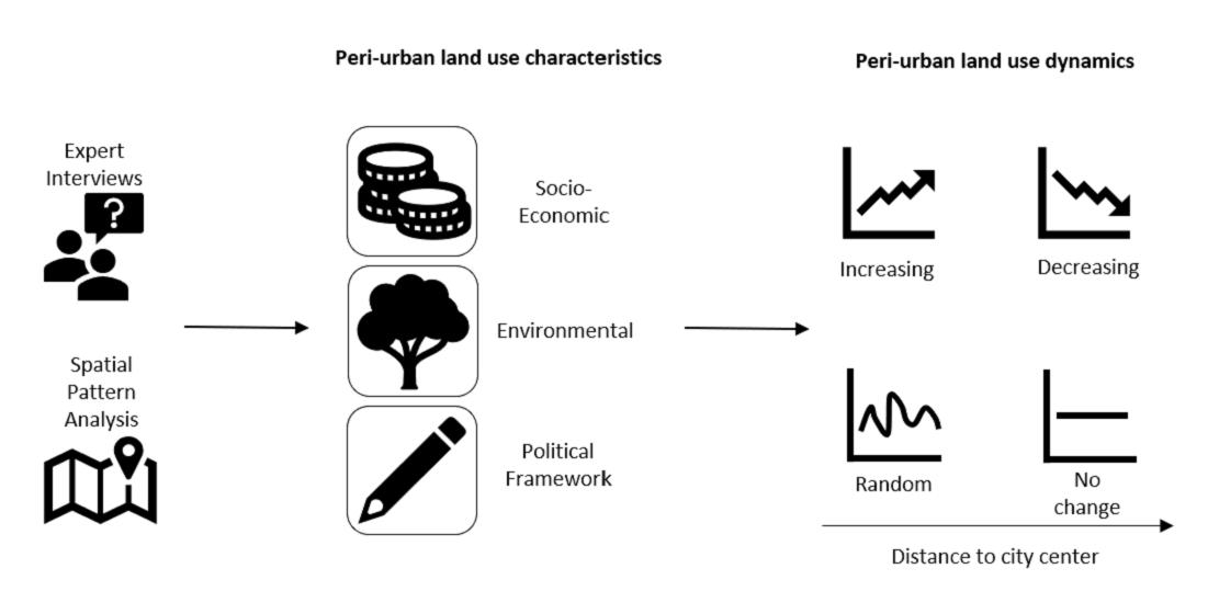
The information derived from expert interviews and the literature review were combined with the results from the spatial data analysis to suggest a generalized scheme characterizing peri-urban development, including environmental (including land cover and proximity to features), social, and economic variables.
3. Results
3.1. Peri-Urban Characteristics and Processes
The majority of interviewees stated that their primary definition of peri-urban is based on the distance to the city center (central business district). This is in line with the Tanzanian Land Act of 1999 that defines peri-urban areas as “those located within a radius of 10 km outside the boundaries of an urban or semi built-up area, which may be prescribed by the Minister for Lands, Housing, and Human Settlements Development” [55]. The definition based on distance seems straight forward; it does not account for the boundary of an urban area or a semi-built-up area, which, unlike administrative entities (regional, districts, wards, mtaa1 areas, etc.), is evolving and shifting as towns and cities expand. In the Dar es Salaam Master Plan (guideline for urban land use development and zoning) [57], the peri-urban is the target location for settlements, infrastructures, and areas of preservation of croplands in the urban fringe.
Furthermore, infrastructure conditions characterize the peri-urban, especially the limited access to roads and public transport. Access to roads is limited, not only by availability, but also by road quality. Most of the roads are gravel; tarmac roads are rare, except major routes connecting municipalities. Transport infrastructure depends on decision makers (ward administration) and the priorities set by the Tanzania Rural and Urban Roads Authorities. Roads are built on demand and small access roads are built after the construction of houses (Interviewee #4).
In Dar es Salaam, development of houses primarily takes place along major roads, with land prices increasing with proximity to major roads, but also with the possibility to include shops that provide income (Interviewees #1 and #3). Transport mostly requires private cars, since public transport is not well developed. Citizens of DSM mostly rely on Daladala (small buses), Bajaj (three-wheeled motorized vehicles), and Bodaboda (motorcycle taxis); however, bus stops are only established if an (undefined) threshold of population is reached. Thus, motorcycle taxis are the most common mean of transport in the peri-urban, also because they can commute on smaller access streets or pathways.
According to all interviewees, and in accordance with the literature, the peri-urban is additionally characterized by a lack of service structures for water (Figure 2) and electricity, as well as schools, hospitals, and dispensaries. The exemplary water storage tank, shown in Figure 2, was a community project in Msongola ward: land is often “donated” from one or more owners for the construction of roads or service buildings (Interviewee #6).
“Most of the peri urban area [have] poor infrastructure, especially roads. And in urban area[s] there [area the requirements of] poor people. Basic needs, especially hospital[s], clean water, even electricity. Even schools. Especially government and private schools are [lacking] in peripheral areas. ”(Interviewee #2).
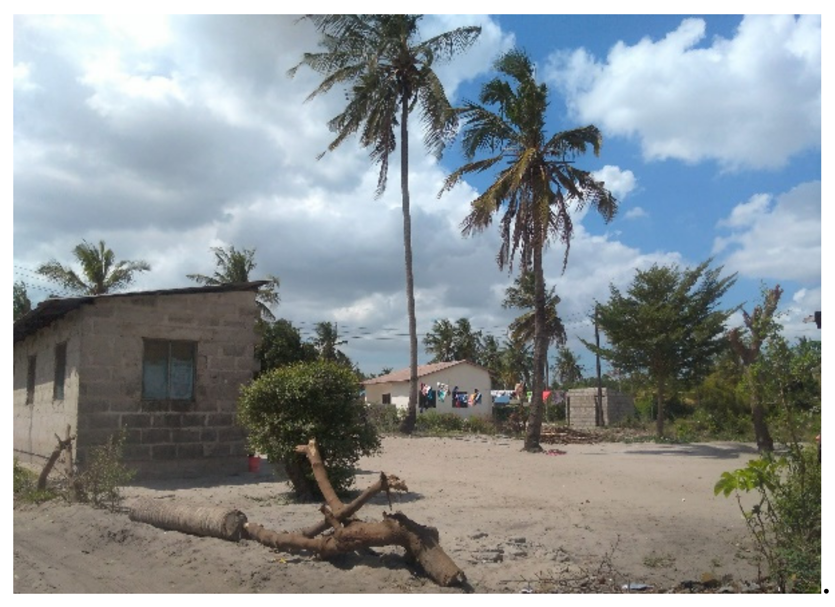
The main reason for ongoing land use changes, mainly from agricultural to residential use, is that urban dwellers move to more remote peri-urban areas because of cheaper land prices and the desire to own property instead of renting (Interviewees #2, #4, and #5). Other pull factors include the possibility for agriculture and the lower crime rates than in urban centers (Interviewee #6). If a farmer sells their property, the land is first divided and sold in small sections. Therefore, trees are cleared from the land, except some isolated trees (e.g., cashew or coconut nut) (Figure 3) that do not require maintenance and are often used as property boundary marking.
“… These were the areas which were formerly very green, and used as the lands of the city. Food production was [done] in these areas. Now people moving in are clearing the green area, they clear the trees, [so there is] no more land for farming. It is only residential. So, it is […] transforming them into urban [areas]. Even [if] there had been natural resources found in those areas, they are no longer there. It is only houses, houses, houses.”(Interviewee #6).
Agricultural activity changes from large to small-scale: it is concentrated within the river valleys and limited to vegetable production. These small plots are mainly managed by women whose families either own or rent the plots. Potential land buyers are middle to high income and can afford to commute between the peri-urban and their place of work, usually in the city center. Land ownership often remains unclear, and land can be sold more than once to multiple owners, resulting in shifting property boundaries and conflicts of ownership. Characteristic structures of these conflicts are unfinished brick houses, marking the owners right to a piece of land (Figure 4). This is also due to nonexistent or unfeasible planning hierarchy and strategies; however, local planning authorities interviewed in this study state the necessity for those strategies to come from a regional governmental level. These strategies include customized and context-specific planning “to make sure [peri-urban areas] are not going back to where they come from and being a replica of urban areas, which are informalizing” (Interviewee #6). In Dar es Salaam, local authorities of the wards organize themselves with the help of citizens, in a demand-based system; for example, when certain population thresholds are reached. This includes the development of new Daladala stops, schools, and health facilities, which are then implemented with the help of the superordinate authorities, i.e., the ward and city administration.
“Yes, there is a challenge […] and issues [with] urban planning. Some [urban settlements] are planned and others are built without any plan so as time goes on, the issues of urban planning become[s] difficult.”(Interviewee #5).
Peri-urban areas function as a dynamic continuum for people, goods, and services, linking these areas to the city center. The characteristics of the peri-urban areas need to be determined by incorporating an environmental, socio-economic, and political framework. To assess and describe the peri-urban, the following set of indicators can be used (Figure 5):
3.2. Spatial Patterns along a Peri-Urban Gradient
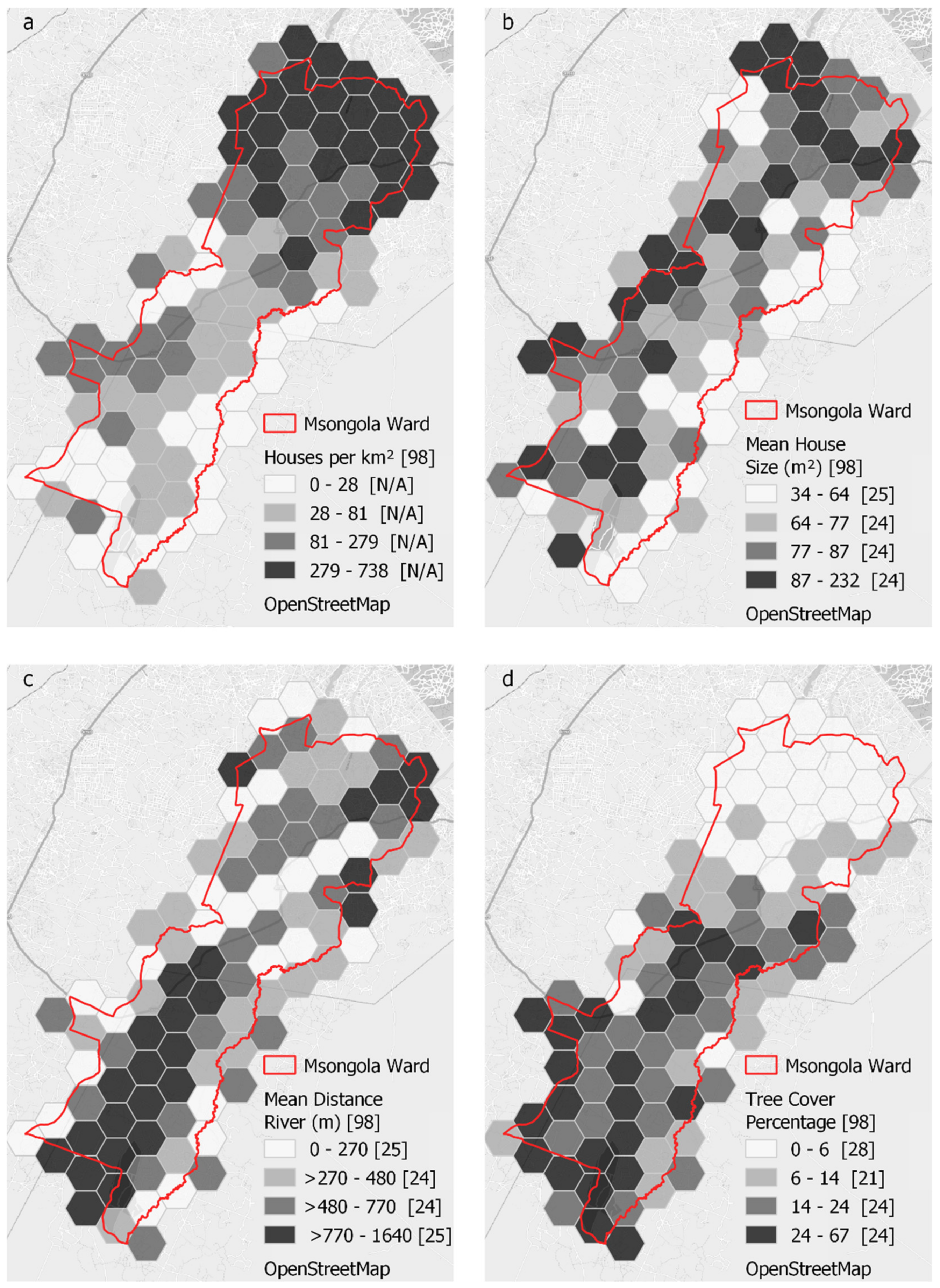
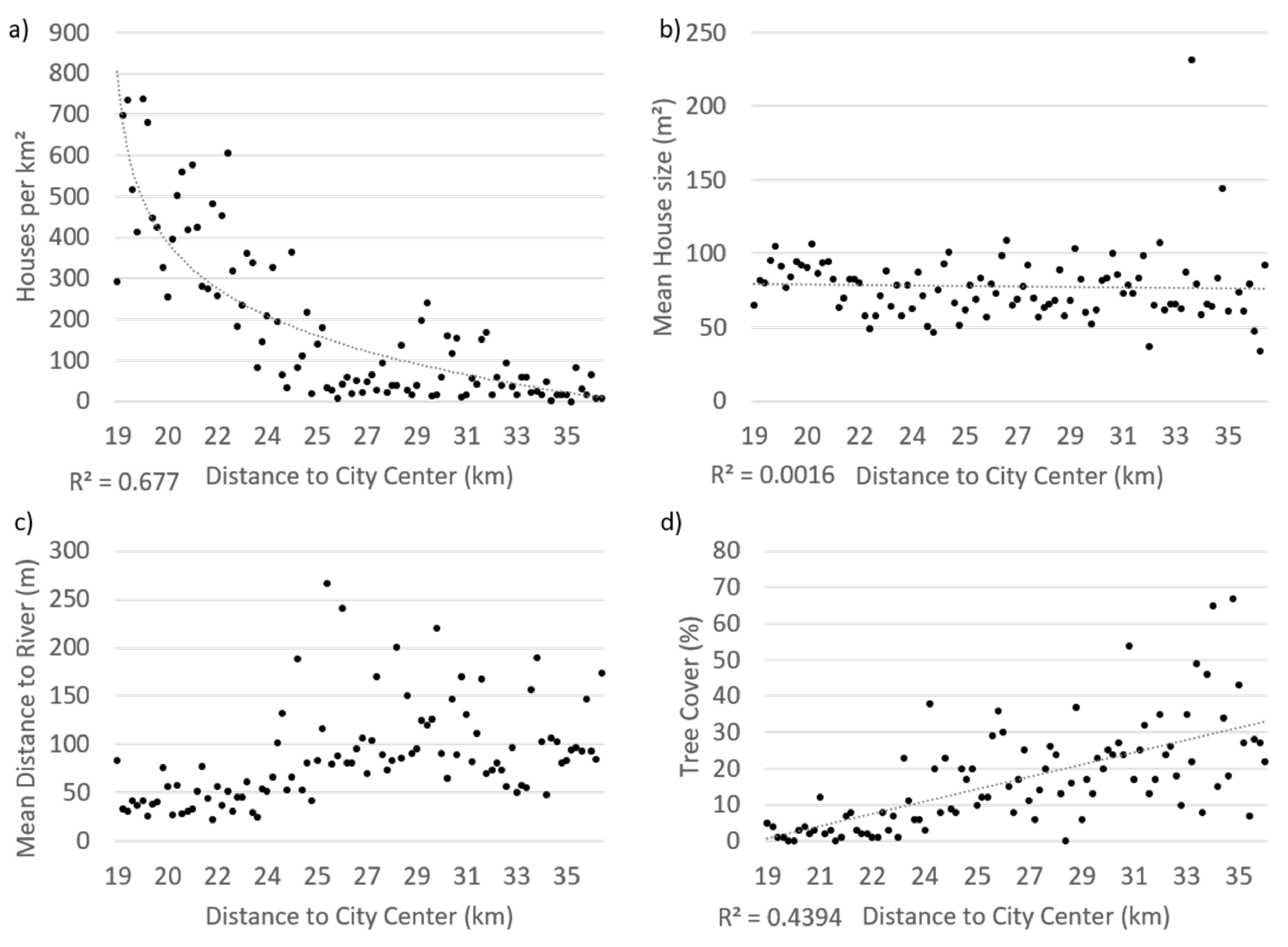
For the selected set of the identified indicators (Figure 5, Table 1), spatial patterns on the peri-urban gradient were analyzed on a 1 km2 hexagonal grid of the Msongola ward. These included housing density, mean house size, tree coverage, road density, distance to central business district (CBD), mean distance to main road from buildings, and mean distance to river from buildings. One characteristic per category is illustrated in the maps in Figure 6 and a scatter diagram of dependence to distance from the city center in Figure 7.
Houses per km2 (i.e., one grid cell) showed a strongly decreasing trend with increasing distance from the city center, with a maximum value of 738/km2 at 20 km distance and a minimum of 0/km2 at 35 km distance (Figure 7a). On the contrary, tree coverage increases, with highest value of 67% of the cell area at 35 km distance and a minimum of 0% at 20 km distance. Areas with lower housing density show higher tree coverage. The random distribution of values, e.g., mean distance to river (Figure 7c), is due to natural landforms resulting in an unpredictable distribution of values. The mean distance to a river (from buildings) ranges from 22 to 267 m (Figure 7c). Mean house size remain constant with increasing distance to city center ranging from 34 to 232 m2, with a mean house size of 78 m2 (Figure 7b). The spatial patterns are in line with the statements from the expert interviews. The decreasing house density with increasing distance to the city center illustrates the availability of space for house development for cheap prices. Increasing tree coverage along the gradient area is connected to the clearance of plots, and former farm area, in order to build houses. This clearance of former large-scale agricultural areas leads to limited availability of agricultural land, which is concentrated in river valleys. As a consequence, some dwellers have to rent agricultural plots from other landowners in the river area. Hence, the spatial distribution of mean distance to rivers results in a rather random pattern but with a majority of grid cells showing values below 100 m. Preferably, houses are built in close distance to river valleys. The changes in spatial patterns on the peri-urban gradient can be differentiated into four categories: increasing or decreasing (with distance to city center), constant/no change, and random (unpredictable) (Figure 8).
4. Discussion
The findings from this case study of Dar es Salaam suggest that the peri-urban is a highly dynamic space with specific characteristics and processes. In particular, it is characterized by poor accessibility and a lack of service infrastructures, as determined by Kombe [36]. The urban–rural fringe, located between an urban area and the rural regions, shows a particular landscape structure that differs in land use patterns from both the urban and rural regions and is characterized by rapid development and changes over time. The quantitative findings on land use patterns, e.g., housing or road density, support earlier studies [3,6,58], showing a decreasing trend with increasing distance to the city center. Experts and legal documents primarily define the peri-urban with a focus on distance to the city center, which is even considered in the definition given in the Tanzania Land Act (1999) [55]. The consideration of peri-urban space on its own, opposed to urban or rural areas, is highlighted by many studies [33,59,60], which emphasizes that the simple dichotomy between the urban and rural must be overcome for planning and policy strategies [3,29,42]. On the other hand, Karg et al. [3] argue that planning policies are often reflected in the administrative, dichotomous entities of “urban” and “rural” that do not adequately reflect the real-world situation in many cities. However, the peri-urban is not necessarily tied to administrative boundaries or entities of an urban area [61] but is strongly linked to the urban (and the rural) by forward and backward flows of people (migration), goods (trade), and money (investment) [3,62]. Two very important factors for peri-urban development are the land price and the land tenure system. In terms of tenure, Msangi [33] noted that peri-urban areas exhibit both customary (commons may be owned by indigenous peoples or other communities with customary tenure systems, and this may be legally recognized [63]) and quasi-customary arrangements. Quasi-customary refers to land tenure arrangements where occupiers have acquired land from customary holders largely through non-customary modes such as purchasing [36]. Land acquisition is strongly linked to different actors, i.e., institutions, land owners, or local authorities [33,64]; however, this is beyond the scope of this research. Land price and actual construction of houses is influenced by different variables, including accessibility and service provision [33,65]: if a road is connected to the parcel, it becomes more expensive. This is also reflected by the decreasing road density along the peri-urban gradient: hypothetically, land price shows a similar gradual pattern. To determine accessibility, features from OSM were chosen that are suitable for vehicles; however, particularly paths and footways can be frequented by motorcycle taxis as well.
The development of peri-urban space can follow different spatial patterns. According to the Village Magnet and Ribbon theory [7] and the interviewees in this study and confirmed by the spatial data analysis, high shares of development take place around (former) village centers and major roads. This is mainly revealed through house densities per square kilometer along the grid overlaying Msongola ward, where small agglomerations of higher building densities along major roads were identified. According to the interviewees, one major difference compared to peri-urban areas of the Global North is that the main function of buildings is residential, with rarely a mixture of purposes [2], except small commercial shops at bus stops or on the front of buildings, for example [4]. Independent from the area, studies worldwide emphasize the integration of peri-urban areas into sustainable development monitoring and planning. According to Wandl et al. [18], peri-urban areas have enormous potential to play a positive role in enhancing urban sustainability, which is in line with our interview results. Sustainable development of peri-urban areas include better-tailored planning and development of built-up areas in order to limit the transformation of open spaces [18,66]. At the same time, peri-urban areas are under increasing pressure regarding the provision of ecosystem services like recreation or food production [66]. However, a better balanced and more sustainable development requires more policy attention at the regional level and the urban–rural interface [67]. Peri-urban areas present opportunities to shape ecological networks and to foster productive economic activity [18]. For example, Magoni et al. [68] describe how innovative integrated planning has addressed multifunctionality in peri-urban areas by bringing together food production with environmental and landscape planning.
With the set of indicators and the spatial trend of the peri-urban gradient, we propose a systematic assessment and characterization of patterns and processes. These indicators are similar to those suggested by Karg et al. [3] to identify access, services, and built-up areas for peri-urban classification; these are structured according to three dimensions of sustainability: environmental, socio-economic, and policy framework. This is in-line with ongoing discussions and policy aims for achieving sustainability goals of food security (Goal 2) and inclusive, safe, resilient, and sustainable settlements (Goal 11) [44]. All dimensions and characteristics cannot be fully captured, but the results from the literature review and expert analysis reveal the most important ones on which to focus. To the best of our knowledge, this is the first time the trends in these indicators have been categorized over the peri-urban gradient. These indicators can be modified and utilized for other study areas. As studies of other regions/cities have shown, a comparative approach might reveal additional insights [15,69,70,71].
There are a number of uncertainties and limitations of this study. First, the focus of this research is on a specific study area and peri-urban subset in Dar es Salaam. The direct transferability of these results (i.e., spatial patterns and dynamics of specific indicators) to other areas is, therefore, limited and is also not the aim of this study. Instead, the detailed insights from this study can be used to develop a set of indicators to characterize the peri-urban. Second, due to a lack of official spatial and temporal data on land use, infrastructure, or population on a suitable spatial resolution, not all variables could be analyzed quantitatively. Alternatively, crowd-sourced OSM data was used, with additional digitalization to meet the requirements of this study. Using this kind of open-source spatial data, the quality of data cannot be guaranteed due to the type of data assessment [50]. To identify the high spatio-temporal dynamics of the peri-urban, new remote sensing datasets with high temporal resolution, such as Sentinel, offer additional possibilities for future studies to explore the dynamics in more detail. Thirdly, we relied on few expert interviews in this study and did not do a representative quantitative survey covering different administrative levels beyond the one ward. However, the aim of this paper was to explore and identify the characteristics in an initial step and, therefore, the qualitative in-depth interviews produced good results for this aim.
The results from the applied mixed-method approach for analyzing peri-urban characteristics has the advantage that information derived from the qualitative research can be incorporated into the quantitative method and that their outcomes can be compared [72]. In the analysis of indicators to assess peri-urban characteristics, methods from social science perspectives provide more information; therefore, a combination of qualitative and quantitative data analyses from natural and social sciences are applied. The methodology draws from local community knowledge to provide background information and develops a backdrop of social relations that produce the spatial patterns of peri-urban land use [73].
5. Conclusions
In our study, we propose a conceptual identification of indicators characterizing the urban–rural interface in terms of spatio-temporal dynamics. While results and trends might differ for other study areas, the methodological set and categorization of dynamics (random, no change, increasing, decreasing) can be transferred and utilized for the characterization of peri-urban areas using a gradient approach. In Dar es Salaam, the peri-urban is characterized by socio-economic challenges including the lack of infrastructure and services, i.e., schools, hospitals, or land ownership. Environmental challenges include the clearance of vegetation, particularly trees and availability of land for large-scale agricultural cultivation. These patterns could also be identified in spatial dynamics along a peri-urban gradient, including a decreasing house density, which relates to available land and the flow of people through migration. At the same time, large scale agriculture mostly vanished and small-scale cultivation is mainly linked to river valleys. As a consequence, access to agricultural land is limited, also related to conflicts in land ownership. Many households have no property at the river but need to rent agricultural plots. The limited availability of agricultural space in peri-urban areas is critical, particularly considering its function as food production areas. In terms of sustainable transformations, the city planning of Dar es Salaam focuses on the implementation of sustainable city development goals, which is also reflected by the wish of local administrations for formalization and support by planning authorities.
In general, sub-Saharan African cities, including DSM, are growing unmonitored and without adequate urban planning [35,36,38]. Planning and policies have to address the specific dynamics and the spatio-temporal gradient in the peri-urban. The city center is closely linked to the peri-urban and needs to be considered as a continuum (of people, including transport and housing, and products, e.g., agricultural products). Particularly the provision of service infrastructures plays a decisive role and needs to be tackled in planning and political strategies. To face the continuous population increase in Dar es Salaam and other cities in the GS, providing living space and food production in a sustainable manner remains one of the major challenges. The peri-urban area, where urban and agriculture intermingle, should be the focus of future research, policies, and planning.
Author Contributions
Conceptualization, S.W., M.V.M., and T.L.; methodology: S.W. and T.L.; investigation: S.W.; data curation: S.W.; writing—original draft preparation: S.W.; writing—review and editing: M.V.M. and T.L.; visualization: S.W.; supervision: T.L. All authors have read and agreed to the published version of the manuscript.
Funding
The field trip was funded by Erasmus+ through EAGER Trans-Net.
Institutional Review Board Statement
Not applicable.
Informed Consent Statement
Informed consent was obtained from all subjects involved in the study.
Data Availability Statement
Data was obtained from OpenStreetMap (OSM), available at https://planet.openstreetmap.org, the European Space Agency (ESA) and are available at http://2016africalandcover20m.esrin.esa.int/ and ICPAC Geoportal available at http://geoportal.icpac.net with the permission of OSM, ESA or ICPAC.
Acknowledgments
We acknowledge support by the German Research Foundation (DFG) and the Open Access Publication Fund of Humboldt-Universität zu Berlin.
Conflicts of Interest
The authors declare no conflict of interest.
Appendix A

Table A1.
List of interview dates and expert function.
| # | Date | Function |
|---|---|---|
| 1 | 12 September 2017 | Town Planner |
| 2 | 18 September 2017 | Community Development Officer |
| 3 | 20 September 2017 | Executive Officer |
| 4 | 20 September 2017 | School Principal |
| 5 | 21 September 2017 | Community Development Officer |
| 6 | 29 September 2017 | Researcher |
Appendix B. Interview Guidelines
Date:
Institution: Interviewee:
Introduction
- Introduction of project …
- Anonymity agreement, recording
- Function of the expert
- Current position and area of responsibility
Background
- How would you describe peri-urban areas?
- What are the characteristics and functions?
- What are challenges?
Structure and Characteristics
- What is the major structural change occurring?
- Peri-urban farms: What are specific characteristics/how are they organized?
- What is the difference to rural farms?
- What are biophysical characteristics/limitations? (natural elements)
- What are limiting/relevant socio-economic characteristics?
- How is the peri-urban connected to …… rural areas?… urban areas?
Interests and Strategies
- What are people’s (farmer, residents) motivation to settle in peri-urban areas?
- Where do they come from?
- What are people’s long-term plans?
- What are strategies to achieve long term plans?
Regulations and Decision Making
- Who are the relevant actors, decision makers, and authorities?
- What is the role of different institutions?
- What responsibilities do they have?
- How do actors interact?
- What are current policy and planning strategies?
- How are strategies implemented in practice?
- What are the formal/informal aspects, regulations?
- How does the city react towards the increasing population pressure and rising demand for settlements?
Perception and Opinion
- How does lifestyle, e.g., household type, affect land use decisions?
- What are future expectations, trends?
- Additional comments?
References
- United Nations Human Settlements Programme. The state of African cities 2014. In Re-Imagining Sustainable Urban Transitions; Un-Habitat: Nairobi, Kenya, 2014; ISBN 9789211325980. [Google Scholar]
- Peri-Urban Futures. Scenarios and Models for Land Use Change in Europe; Nilsson, K., Pauleit, S., Bell, S., Aalbers, C., Eds.; Springer: Berlin, Germany, 2013; ISBN 978-3-642-30529-0. [Google Scholar]
- Karg, H.; Hologa, R.; Schlesinger, J.; Drescher, A.; Kranjac-Berisavljevic, G.; Glaser, R. Classifying and Mapping Periurban Areas of Rapidly Growing Medium-Sized Sub-Saharan African Cities: A Multi-Method Approach Applied to Tamale, Ghana. Land 2019, 8, 40. [Google Scholar] [CrossRef] [Green Version]
- Nuhu, S. Peri-Urban Land Governance in Developing Countries: Understanding the Role, Interaction and Power Relation Among Actors in Tanzania. Urban Forum 2019, 30, 1–16. [Google Scholar] [CrossRef] [Green Version]
- Lambin, E.F.; Turner, B.L.; Geist, H.J.; Agbola, S.B.; Angelsen, A.; Bruce, J.W.; Coomes, O.T.; Dirzo, R.; Fischer, G.; Folke, C.; et al. The causes of land-use and land-cover change: Moving beyond the myths. Glob. Environ. Chang. 2001, 11, 261–269. [Google Scholar] [CrossRef]
- Schlesinger, J.; Drescher, A. Agricultural land use and the urban-rural gradient: An analysis of landscape metrics in Moshi, Tanzania. Afr. Geogr. Rev. 2016, 37, 14–29. [Google Scholar] [CrossRef]
- Doan, P.L.; Oduro, C.Y. Patterns of Population Growth in Peri-Urban Accra, Ghana. Int. J. Urban Reg. Res. 2011, 36, 1306–1325. [Google Scholar] [CrossRef]
- Banu, N.; Fazal, S. Livelihood and Wellbeing in the Urban Fringe; Springer Nature: Berlin/Heidelberg, Germany, 2016; ISBN1 978-3-319-39659-0. ISBN2 978-3-319-39660-6. [Google Scholar]
- Urban-Rural Interfaces: Linking People and Nature; Laband, D.N.; Lockaby, B.G.; Zipperer, W.C. (Eds.) American Society of Agronomy: Madison, WI, USA; Crop Science Society of America: Fitchburg, WI, USA; Soil Science Society of America: Madison, WI, USA, 2012; ISBN 978-0-89118-615-1. [Google Scholar]
- The Peri-Urban Interface: Approaches to Sustainable Natural and Human Resource Use; McGregor, D.F.M.; Simon, D.; Thompson, D.A. (Eds.) Earthscan: London, UK; Sterling, VA, USA, 2006; ISBN1 978-1-84407-187-6. ISBN2 978-1-84407-188-3. [Google Scholar]
- Meeus, S.; Gulinck, H. Alternative Approaches for Describing Semi Urban Areas; USAMV: Cluj-Napoca, Romania, 2015. [Google Scholar]
- Zasada, I. Multifunctional peri-urban agriculture—A review of societal demands and the provision of goods and services by farming. Land Use Policy 2011, 28, 639–648. [Google Scholar] [CrossRef]
- Zasada, I.; Loibl, W.; Berges, R.; Steinnocher, K.; Köstl, M.; Piorr, A.; Werner, A. Rural–Urban Regions: A Spatial Approach to Define Urban–Rural Relationships in Europe. In Peri-Urban Futures: Scenarios and Models for Land Use Change in Europe; Nilsson, K., Pauleit, S., Bell, S., Aalbers, C., Nielsen, T.A.S., Eds.; Springer: Berlin/Heidelberg, Germany, 2013; pp. 45–68. ISBN1 978-3-642-30528-3. ISBN2 978-3-642-30529-0. [Google Scholar]
- Surya, B. The Processes Analysis of Urbanization, Spatial Articulation, Social Change and Social Capital Difference in the Dynamics of New Town Development in the Fringe Area of Makassar City (Case Study: In Metro Tanjung Bunga Area, Makassar City). Procedia Soc. Behav. Sci. 2016, 227, 216–231. [Google Scholar] [CrossRef] [Green Version]
- Dekolo, S.O.; Oduwaye, L.; Nwokoro, I. Urban Sprawl and Loss of Agricultural Land in Peri-urban Areas of Lagos. Reg. Stat. 2015, 5, 20–33. [Google Scholar] [CrossRef] [Green Version]
- Iaquinta, D.L.; Drescher, A.W. Defining the peri-urban: Rural-urban linkages and institutional connections. Land Reform Land Settl. Coop. 2000, 2000, 8–26. [Google Scholar]
- Ravetz, J.; Fertner, C.; Nielsen, T.S. The Dynamics of Peri-Urbanization. In Peri-Urban Futures: Scenarios and Models for Land Use Change in Europe; Nilsson, K., Pauleit, S., Bell, S., Aalbers, C., Eds.; Springer: Berlin, Germany, 2013; pp. 13–44. ISBN 978-3-642-30529-0. [Google Scholar]
- Wandl, A.; Magoni, M. Sustainable Planning of Peri-Urban Areas: Introduction to the Special Issue. Plan. Pr. Res. 2016, 32, 1–3. [Google Scholar] [CrossRef] [Green Version]
- Gonçalves, J.; Gomes, M.C.; Ezequiel, S.; Moreira, F.; Loupa-Ramos, I. Differentiating peri-urban areas: A transdisciplinary approach towards a typology. Land Use Policy 2017, 63, 331–341. [Google Scholar] [CrossRef]
- Shaw, B.J.; Van Vliet, J.; Verburg, P.H. The peri-urbanization of Europe: A systematic review of a multifaceted process. Landsc. Urban Plan. 2020, 196, 103733. [Google Scholar] [CrossRef]
- Tacoli, C. Rural-urban interactions: A guide to the literature. Environ. Urban. 1998, 10, 147–166. [Google Scholar] [CrossRef]
- Zivanovic-Miljkovic, J.; Crncevic, T.; Maric, I. Land use planning for sustainable development of peri-urban zones. Spatium 2012, 2012, 15–22. [Google Scholar] [CrossRef]
- Nagendra, H.; Bai, X.; Brondizio, E.S.; Lwasa, S. The urban south and the predicament of global sustainability. Nat. Sustain. 2018, 1, 341–349. [Google Scholar] [CrossRef]
- Mbiba, B.; Huchzermeyer, M. Contentious development: Peri-urban studies in sub-Saharan Africa. Prog. Dev. Stud. 2002, 2, 113–131. [Google Scholar] [CrossRef]
- Appiah, D.O.; Schröder, D.; Forkuo, E.K.; Bugri, J. Application of Geo-Information Techniques in Land Use and Land Cover Change Analysis in a Peri-Urban District of Ghana. ISPRS Int. J. Geo Inf. 2015, 4, 1265–1289. [Google Scholar] [CrossRef] [Green Version]
- Shaw, R.; Das, A. Identifying peri-urban growth in small and medium towns using GIS and remote sensing technique: A case study of English Bazar Urban Agglomeration, West Bengal, India. Egypt. J. Remote Sens. Space Sci. 2018, 21, 159–172. [Google Scholar] [CrossRef]
- Mpofu, G.; Darkoh, M.K.; Gwebu, T.D. Peri-urbanization landuse dynamics: An analysis of evolving patterns and their impacts on Gabane Village, Botswana. GeoJournal 2017, 83, 725–741. [Google Scholar] [CrossRef]
- Banzhaf, E.; Grescho, V.; Kindler, A. Monitoring urban to peri-urban development with integrated remote sensing and GIS information: A Leipzig, Germany case study. Int. J. Remote Sens. 2009, 30, 1675–1696. [Google Scholar] [CrossRef]
- Van Vliet, J.; Verburg, P.H.; Grădinaru, S.R.; Hersperger, A.M. Beyond the urban-rural dichotomy: Towards a more nuanced analysis of changes in built-up land. Comput. Environ. Urban Syst. 2019, 74, 41–49. [Google Scholar] [CrossRef]
- Pryor, R.J. Defining the Rural-Urban Fringe. Soc. Forces 1968, 47, 202–215. [Google Scholar] [CrossRef]
- Andreasen, M.H.; Agergaard, J.; Møller-Jensen, L. Suburbanisation, homeownership aspirations and urban housing: Exploring urban expansion in Dar es Salaam. Urban Stud. 2017, 54, 2342–2359. [Google Scholar] [CrossRef] [Green Version]
- Chirisa, I.; Mazhindu, E.; Bandauko, E. Peri-Urban Developments and Processes in Africa with Special Reference to Zimbabwe; Springer Nature: Berlin/Heidelberg, Germany, 2016; p. 978. ISBN1 978-3-319-34230-6. ISBN2 978-3-319-34231-3. [Google Scholar]
- Msangi, D.E. Land Acquisition for Urban Expansion; Institutionen för stad och land, Sveriges lantbruksuniversitet: Uppsala, Sweden, 2011. [Google Scholar]
- Briggs, J.; Mwamfupe, D. The changing nature of the peri-urban zone in Africa: Evidence from Dar-es-Salaam, Tanzania. Scott. Geogr. J. 1999, 115, 269–282. [Google Scholar] [CrossRef] [Green Version]
- Lupala, J.M. Urban Types in Rapidly Urbanising Cities: Analysis of Formal and Informal Settlement in Dar es Sa-laam, Tanzania; Universitetsservice US AB: Stockholm, Sweden, 2002. [Google Scholar]
- Kombe, W.J. Land use dynamics in peri-urban areas and their implications on the urban growth and form: The case of Dar es Salaam, Tanzania. Habitat Int. 2005, 29, 113–135. [Google Scholar] [CrossRef]
- Eckert, S. Urban Expansion and its impact on urban agriculture-remote sensing based change analysis of Kizinga and Mzinga Valley-Dar Es Salaam, Tanzania. EARSeL eProceedings 2011, 10, 46–55. [Google Scholar]
- Mkalawa, C.C.; HaiXiao, P. Dar es Salaam city temporal growth and its influence on transportation. Urban Plan. Transp. Res. 2014, 2, 423–446. [Google Scholar] [CrossRef]
- Bhanjee, S.; Zhang, C.H. Mapping Latest Patterns of Urban Sprawl in Dar es Salaam, Tanzania. Pap. Appl. Geogr. 2018, 4, 292–304. [Google Scholar] [CrossRef]
- Willkomm, M.; Follmann, A.; Dannenberg, P. Rule-based, hierarchical land use and land cover classification of urban and peri-urban agriculture in data-poor regions with RapidEye satellite imagery: A case study of Nakuru, Kenya. J. Appl. Remote Sens. 2019, 13, 016517. [Google Scholar] [CrossRef]
- Wenban-Smith, H. Rural-Urban Linkages: Tanzania Case Study. 2014. Available online: http://rimisp.org/wp-content/files_mf/1422298599R_ULinkages_Tanzania_countrycasestudy_Final_edited.pdf (accessed on 22 February 2017).
- Lerner, A.M.; Eakin, H. An obsolete dichotomy? Rethinking the rural-urban interface in terms of food security and production in the global south. Geogr. J. 2011, 177, 311–320. [Google Scholar] [CrossRef] [PubMed]
- Kleemann, J.; Inkoom, J.N.; Thiel, M.; Shankar, S.; Lautenbach, S.; Fürst, C. Peri-urban land use pattern and its relation to land use planning in Ghana, West Africa. Landsc. Urban Plan. 2017, 165, 280–294. [Google Scholar] [CrossRef]
- Take Action for the Sustainable Development Goals. United Nations. Available online: https://www.un.org/sustainabledevelopment/sustainable-development-goals/ (accessed on 12 November 2020).
- National Bureau of Statistics; Ministry of Finance. Basic Facts and Figures on Human Settlements 2012; National Bureau of Statistics; Ministry of Finance: Abuja, Nigeria, 2013. [Google Scholar]
- National Bureau of Statistics. Tanzania in Figures 2017; National Bureau of Statistics: Dodoma, Tanzania, 2017. [Google Scholar]
- Hill, A.; Hühner, T.; Kreibich, V.; Lindner, C. Dar es Salaam, Megacity of Tomorrow: Informal Urban Expansion and the Provision of Technical Infrastructure. In Megacities; Kraas, F., Aggarwal, S., Coy, M., Mertins, G., Eds.; Springer: Heidelberg, Germany, 2014; pp. 165–177. ISBN1 978-90-481-3416-8. ISBN2 978-90-481-3417-5. [Google Scholar]
- OpenStreetMap Contributors. 2018 Planet Dump. Available online: https://planet.openstreetmap.org (accessed on 5 September 2018).
- ESA CCI LAND COVER—S2 Prototype Land Cover 20 m Map of Africa 2016. Available online: http://2016africalandcover20m.esrin.esa.int/ (accessed on 18 March 2019).
- Grippa, T.; Georganos, S.; Zarougui, S.; Bognounou, P.; Diboulo, E.; Forget, Y.; Lennert, M.; VanHuysse, S.; Mboga, N.; Wolff, E. Mapping Urban Land Use at Street Block Level Using OpenStreetMap, Remote Sensing Data, and Spatial Metrics. ISPRS Int. J. Geo Inf. 2018, 7, 246. [Google Scholar] [CrossRef] [Green Version]
- ICPAC Geoportal. Tanzania—Rivers. Available online: http://geoportal.icpac.net/layers/geonode%3Atza_water_lines_dcw (accessed on 7 September 2019).
- Mayring, P. Qualitative Content Analysis. Forum Qual. Soz. Forum Qual. Soc. Res. 2000, 1. [Google Scholar] [CrossRef]
- Appiah, D.O.; Bugri, J.T.; Forkuor, E.K.; Boateng, P.K. Determinants of Peri-Urbanization and Land Use Change Patterns in Peri-Urban Ghana. J. Sustain. Dev. 2014, 7, p95. [Google Scholar] [CrossRef] [Green Version]
- Birch, C.P.; Oom, S.P.; Beecham, J.A. Rectangular and hexagonal grids used for observation, experiment and simulation in ecology. Ecol. Model. 2007, 206, 347–359. [Google Scholar] [CrossRef]
- Parliament of the United Republic of Tanzania. The Land Act 1999; Government Printers: Dar es Salaam, Tanzania, 1999. [Google Scholar]
- Commonwealth Local Government Forum. Country Profile—Tanzania: The Local Government System in Tanzania. 2017. Available online: http://www.clgf.org.uk/default/assets/File/Country_profiles/Tanzania.pdf (accessed on 22 December 2020).
- Ministry of Lands, Housing and Human Settlement Development. Dar es Salaam Master Plan 2016–2036; Ministry of Lands, Housing and Human Settlement Development: Dar es Salaam, Tanzania, 2016. [Google Scholar]
- Peng, J.; Zhao, S.; Liu, Y.; Tian, L. Identifying the urban-rural fringe using wavelet transform and kernel density estimation: A case study in Beijing City, China. Environ. Model. Softw. 2016, 83, 286–302. [Google Scholar] [CrossRef]
- Bhanjee, S. Urban (un)Planning and Social Vulnerability in the Context of Rapid Urbanization and Data Constraints: A Quantitative Study of Dar es Salaam, Tanzania. Ph.D. Thesis, University of Louisville, Louisville, Kentucky, USA, 2019. [Google Scholar]
- Adam, A.G. Land Tenure in the Changing Peri-Urban Areas of Ethiopia: The Case of Bahir Dar City. Int. J. Urban Reg. Res. 2014, 38, 1970–1984. [Google Scholar] [CrossRef]
- Allen, A. Environmental planning and management of the peri-urban interface: Perspectives on an emerging field. Environ. Urban. 2003, 15, 135–148. [Google Scholar] [CrossRef]
- Tacoli, C. The links between urban and rural development. Environ. Urban. 2003, 15, 3–12. [Google Scholar] [CrossRef]
- FAO. Governing tenure rights to commons. In A Guide to Support the Implementation of the Voluntary Guidelines on the Responsible Governance of Tenure of Land, Fisheries and Forests in the Context of National Food Security; Food and Agriculture Organization of the United Nations: Rome, Italy, 2016; ISBN 978-92-5-109483-9. [Google Scholar]
- Nuhu, S. Land-access systems in peri-urban areas in Tanzania: Perspectives from actors. Int. J. Urban Sustain. Dev. 2019, 11, 189–202. [Google Scholar] [CrossRef]
- Namangaya, A.H.; Kiunsi, R. Assessing the influences of service provision on pace and short and medium term development patterns of residential housing in Dar es Salaam. Geogr. Tidsskr. J. Geogr. 2018, 118, 151–159. [Google Scholar] [CrossRef]
- Hedblom, M.; Andersson, E.; Borgström, S. Flexible land-use and undefined governance: From threats to potentials in peri-urban landscape planning. Land Use Policy 2017, 63, 523–527. [Google Scholar] [CrossRef]
- Peri-Urbanisation in Europe: Towards European Policies to Sustain Urban-Rural Futures: Synthesis Report; Piorr, A.; Plurel (Eds.) Forest & Landscape, University of Copenhagen: Frederiksberg, Denmark, 2011; ISBN 978-87-7903-534-8. [Google Scholar]
- Magoni, M.; Colucci, A. Protection of Peri-Urban Open Spaces and Food-System Strategies. The Case of Parco delle Risaie in Milan. Plan. Pr. Res. 2015, 32, 40–54. [Google Scholar] [CrossRef]
- Follmann, A.; Hartmann, G.; Dannenberg, P. Multi-temporal transect analysis of peri-urban developments in Faridabad, India. J. Maps 2018, 14, 17–25. [Google Scholar] [CrossRef]
- Liu, J.; Liu, Y.; Yan, M. Spatial and temporal change in urban-rural land use transformation at village scale—A case study of Xuanhua district, North China. J. Rural. Stud. 2016, 47, 425–434. [Google Scholar] [CrossRef]
- Salem, M. Peri-urban dynamics and land-use planning for the Greater Cairo Region in Egypt. In WIT Transactions on The Built Environment, 1st ed.; Brebbia, C.A., Ed.; WIT Press: Southampton, UK, 2015; pp. 109–119. ISBN 978-1-78466-157-1. [Google Scholar]
- Kleemann, J.; Baysal, G.; Bulley, H.N.; Fürst, C. Assessing driving forces of land use and land cover change by a mixed-method approach in north-eastern Ghana, West Africa. J. Environ. Manag. 2017, 196, 411–442. [Google Scholar] [CrossRef]
- Koti, F.; Weiner, D. (Re) Defining Peri-Urban Residential Space Using Participatory GIS in Kenya. Electron. J. Inf. Syst. Dev. Ctries 2006, 25, 1–12. [Google Scholar] [CrossRef]
| 1. | Wards can be sub-divided into urban wards, “mtaa” (Kiswahili for streets) [56]. |
Figure 1.
Study region of Dar es Salaam with (a) Msongola ward details with data including rivers, roads, and buildings and hexagonal grid overlay and (b) Location of Msongola ward in the city of Dar es Salaam.
Figure 1.
Study region of Dar es Salaam with (a) Msongola ward details with data including rivers, roads, and buildings and hexagonal grid overlay and (b) Location of Msongola ward in the city of Dar es Salaam.

Figure 2.
Example of an elevated water storage tank as a water supply system (photo: Saskia Wolff 2017).
Figure 2.
Example of an elevated water storage tank as a water supply system (photo: Saskia Wolff 2017).

Figure 3.
Single trees between residential plots that remained after clearance of the area for house development (photo: Saskia Wolff 2017).
Figure 3.
Single trees between residential plots that remained after clearance of the area for house development (photo: Saskia Wolff 2017).

Figure 4.
Unfinished cement block wall house structure, which often remain unfinished due to conflicts about land ownership (photo: Saskia Wolff 2017).
Figure 4.
Unfinished cement block wall house structure, which often remain unfinished due to conflicts about land ownership (photo: Saskia Wolff 2017).

Figure 5.
Set of indicators to characterize the peri-urban, with regard to sustainability pillars. Socio-economic indicators include social and economic indicators, as well as accessibility; environmental includes ecological factors and conditions including land cover; the political framework refers to planning guidelines of land development.

Figure 6.
Maps of peri-urban spatial characteristics in four categories: (a) decreasing with distance to city center, (b) constant, (c) random, and (d) increasing with distance to city center (central business district).
Figure 6.
Maps of peri-urban spatial characteristics in four categories: (a) decreasing with distance to city center, (b) constant, (c) random, and (d) increasing with distance to city center (central business district).

Figure 7.
Distribution of values along a peri-urban gradient with trend lines for the following categories (a) decreasing houses per km2 with distance to city center, (b) constant house size, (c) random mean distance to river (m), and (d) increasing tree cover (%) with distance to city center.
Figure 7.
Distribution of values along a peri-urban gradient with trend lines for the following categories (a) decreasing houses per km2 with distance to city center, (b) constant house size, (c) random mean distance to river (m), and (d) increasing tree cover (%) with distance to city center.

Figure 8.
Spatial dynamics of characteristics on a perio-urban gradient.

Table 1.
Indicators calculated for spatial pattern analysis.
| Variable | Indicator for | Data Source | Processing (1 km2 Grid Cells) |
|---|---|---|---|
| Land Cover/Use | |||
| House Density | Urban density and proxy for population density | Open Street Map [37] | Houses per km2 |
| House Size | Building size | Open Street Map [37] | Mean house size per km2 |
| Tree Coverage | Land degradation | CCI Landcover [38] | Share of tree cover per km2 |
| Proximity | |||
| Road density | Access to transport and infrastructure density | Open Street Map [37] | Road length km per km2 |
| Distance to city center | Proximity to city center (central business district) | Centroid central business district | Hub Distance from cell centroid |
| Distance to main roads | Access to transport and infrastructure density | Open Street Map [37] | Mean distance from house centroids |
| Distance to river | Access to water resources | ICPAC Geoportal [40] | Mean distance from house centroids |
Publisher’s Note: MDPI stays neutral with regard to jurisdictional claims in published maps and institutional affiliations. |
© 2021 by the authors. Licensee MDPI, Basel, Switzerland. This article is an open access article distributed under the terms and conditions of the Creative Commons Attribution (CC BY) license (http://creativecommons.org/licenses/by/4.0/).
Share and Cite
MDPI and ACS Style
Wolff, S.; Mdemu, M.V.; Lakes, T. Defining the Peri-Urban: A Multidimensional Characterization of Spatio-Temporal Land Use along an Urban–Rural Gradient in Dar es Salaam, Tanzania. Land 2021, 10, 177. https://doi.org/10.3390/land10020177
AMA Style
Wolff S, Mdemu MV, Lakes T. Defining the Peri-Urban: A Multidimensional Characterization of Spatio-Temporal Land Use along an Urban–Rural Gradient in Dar es Salaam, Tanzania. Land. 2021; 10(2):177. https://doi.org/10.3390/land10020177
Chicago/Turabian StyleWolff, Saskia, Makarius V. Mdemu, and Tobia Lakes. 2021. "Defining the Peri-Urban: A Multidimensional Characterization of Spatio-Temporal Land Use along an Urban–Rural Gradient in Dar es Salaam, Tanzania" Land 10, no. 2: 177. https://doi.org/10.3390/land10020177
Note that from the first issue of 2016, this journal uses article numbers instead of page numbers. See further details here.