Article

Effects of Agricultural Reclamation on Soil Physicochemical Properties in the Mid-Eastern Coastal Area of China

1
School of Geography Science and Geomatics Engineering, Suzhou University of Science and Technology, Suzhou 215009, China
2
The Key Laboratory of the Coastal Zone Exploitation and Protection, Ministry of Natural Resources, Nanjing 210024, China
3
School of Geography and Ocean Science, Nanjing University, Nanjing 210023, China
4
Graduate School of Advanced Science and Engineering, Hiroshima University, Higashihiroshima 7398529, Japan
5
Jiangsu Land Surveying and Planning Institute, Nanjing 210024, China
6
College of Geography and Environmental Sciences, Zhejiang Normal University, Jinhua 321004, China
*
Author to whom correspondence should be addressed.
Land 2021, 10(2), 142; https://doi.org/10.3390/land10020142
Submission received: 24 December 2020 / Revised: 23 January 2021 / Accepted: 29 January 2021 / Published: 2 February 2021
(This article belongs to the Section Landscape Ecology)

Abstract

:
Agricultural reclamation in coastal zones is effective for mitigating population pressure on the food supply. Soil properties are important factors influencing crop production in reclaimed coastal lands. This study aims to investigate the impacts of time and land use trajectories on soil physicochemical properties after reclamation. We sampled soils in areas that were reclaimed in 1999, 1998, 1991, 1989, 1986, 1981, and 1979 and determined some soil physicochemical properties such as electrical conductivity with a 1:5 soil:water ratio (EC1:5), exchange sodium percentage (ESP), sodium adsorption ratio (SAR), pH, organic matter (OM), total nitrogen (TN), alkaline hydrolyzable nitrogen (AN), cation exchange capacity (CEC), total phosphorus (TP), available phosphorus (TP) and soil particle size ratio. We analyzed their correlation with land use and the time since reclamation using one-way analysis of variance (ANOVA) and principal component analysis (PCA). The results showed that soil physicochemical properties changed significantly after agricultural reclamation. Soil EC1:5, ESP, and SAR declined rapidly, and OM, TN, and AN increased rapidly during the 29 years after reclamation. The soil particle size ratio was not significantly correlated with reclamation time. The land-use trajectories identified after reclamation had obvious effects on soil physicochemical properties. Aquaculture ponds were superior to cultivated land in terms of decreasing soil salinity but were inferior in terms of soil nutrient accumulation. In the future, more attention should be given to the environmental effects of agricultural reclaimed soils.

1. Introduction

Due to industrialization and urbanization, conflicts related to human land use and the limited land resources in coastal zones have become increasingly prominent [1,2]. Coastal reclamation has been effective in mitigating these conflicts and has contributed greatly to economic growth and urbanization processes in The Netherlands, Japan, South Korea, and China [1], although coastal reclamation has led to a greater decrease in ecosystem services [3]. Coastal reclaimed lands have been developed mainly for agriculture, salt production, mariculture, port construction, and industrial uses [1,4]. Before 2017, all districts in Jiangsu Province, China, continued their ambitions to reclaim land, caused by both local economic needs and provincial coastal strategies [5]. The limited no-reclaimed land available, strict national reclamation control and ecological security might constrain such ambitions. These limitations can also be found in other coastal parts of China such as the Yellow Sea region and the Pearl River Delta where economic development intensifies coastal reclamation while the loss of coastal wetlands challenges these activities. Therefore, land use and its environmental effects on reclaimed land are very important for coastal sustainability.
Tidal flats in natural coastal marshes are formed by sediment deposition and affected by seawater immersion [6]. Coastal reclamation through dam construction, suspended material being pumped into the enclosed area and artificial drainage exerts significantly high impacts on the coastal environment and ecosystems, especially on the sediment environment. After reclamation, the coastal reclaimed tidal flat environment has been largely altered; for example, redox conditions may have changed due to the lowering of the water table and aeration [6]. The tidal sediment gradually evolves into soil after coastal reclamation [7,8]. Land-use/land-cover (LULC) changes are important elements of environmental change [9,10,11]. Land-use types and intensity after coastal reclamation also greatly change soil physicochemical properties, i.e., soil organic carbon, nitrogen and nutrients [5,12,13,14,15,16]. Most of these studies focused on the dynamics of soil physicochemical properties along a chronosequence of soil sites reclaimed in different years [17,18,19]. These studies found that the period approximately 30 years after reclamation is a remarkable stage of soil evolution [17,18,19]. Few studies have focused on the correlation of land-use trajectories with soil physicochemical properties after reclamation during this approximately 30-year period. Historical land use greatly affects changes in soil physicochemical properties [20,21]. Therefore, exploring the evolution of soil properties along the reclamation timeline, the influence of land-use trajectories on reclaimed soil properties, and their correlations in this approximately 30-year period can provide guidance for the restoration and utilization of coastal reclaimed soils.
We hypothesized that soil physicochemical properties would change with time after coastal reclamation, that different land-use trajectories would have different effects on soil properties, and that there would be strong correlations among soil physicochemical properties, reclamation time, and land use. The objectives of this study were: (ⅰ) to describe the process of the changes in soil physicochemical properties after reclamation; (ⅱ) to compare the effects of different land-use trajectories on soil properties; and (ⅲ) to explore the relationships among soil properties, reclamation time, and land-use trajectories after reclamation.

2. Materials and Methods

2.1. Study Area

The study area, located in mid-eastern Jiangsu Province (120°20′–120°53′ E, 34°5′–34°50′ N), is one of the widest and fastest prograding mud flats situated between the Yangtze River estuary and the abandoned Yellow River mouth in China (Figure 1). The area is characterized by a northern humid subtropical monsoon climate with abundant sunlight and rainfall, and the annual mean temperature is 15 °C. The annual mean precipitation is 1028.6 mm. The study area is also the largest low-lying area, mostly between 2 and 3 m above mean sea level [22]. The radial tidal ridge system of the Jiangsu Coast provides an abundant sediment supply [23]. The tidal flats in Jiangsu Province have been prograding since B.C. 220 [22,24]. The soil in the study area was derived from modern marine and fluviatile sediment, which is sandy loam and is characterized by high soil salinity and low soil nutrients [25]. Since 1950, much of the tidal flat area has been reclaimed for cultivation and aquaculture as well as a small amount of industry and forestry [3].

2.2. Soil Sampling and Laboratory Analyses

In October 2015, we collected soil samples of soil undergoing crop cultivation at depths of 0–20 cm from regions reclaimed in 1999, 1998, 1991, 1989, 1986, 1981, and 1979 (Figure 1). In each reclamation zone, six sample sites were established. Soil sampling sites were established based on random principles on cropland soils. Soil samples were collected at each site with five replicates, mixed and homogenized. The soils were in rice-wheat cultivation. The historical land-use types from 1985 to 2015 were identified by photointerpretation of Landsat images. The soil samples were divided into two parts. One part was used to determine the soil particle size distribution (PSD). The other part was air-dried, ground, and passed through 2-mm, 0.25-mm, and 0.149-mm sieves for the determination of soil chemical properties such as the Fe2O3, Al2O3, CaO, and SiO2 content; electrical conductivity with a 1:5 soil:water ratio (EC1:5); exchange sodium percentage (ESP); pH; cation exchange capacity (CEC); organic matter (OM); total nitrogen (TN); total phosphorus (TP); alkaline hydrolyzable nitrogen (AN) and available phosphorus (AP).
All methods used to determine the soil physicochemical properties are described in detail by Lu [26]. In brief, PSD was measured with a Marven 2000 laser particle size analyzer (Worcestershire, UK). pH was measured at a soil:distilled water suspension ratio of 1:5 with a pH meter (FE28, Mettler Toledo, Zurich, Switzerland). EC1:5 was measured at a soil:distilled water suspension ratio of 1:5 with a conductivity meter (FE30, Mettler Toledo, Zurich, Switzerland). Salt ions (Na+, Ca2+, Mg2+) were assayed by inductively coupled plasma optical emission spectrometry (Avio5000, Perkin Elmer, Waltham, MA, USA). TN was determined using an automatic Kjeldahl distillation-titration unit, TP was determined by a colorimetric method after digestion with hydrofluoric and perchloric acids, and organic carbon was measured using exothermic heating and oxidation with the potassium dichromate method. Conversions between values of organic carbon and organic matter (OM) were made using a Van Bemmelen factor of 1.724. AN was assayed by the alkali-hydrolyzed diffusion method, AP was determined by sodium bicarbonate extraction and molybdenum blue colorimetry, and CEC was determined by the sodium acetate method. The exchangeable Na+ was measured by ammonium acetate-ammonium hydroxide exchange using a flame photometer (FP6431, Shanghai Jingke, Shanghai, China). The equations for ESP and the sodium adsorption ratio (SAR) are as follows:
ESP = Exchangeable Na+/CEC
SAR = Na+/((Ca2+ + Mg2+)/2)1/2

2.3. Data Processing and Analysis

One-way analysis of variance (ANOVA) was used to investigate the differences in soil physicochemical properties among different reclamation years and cultivation years. The mean comparisons were performed using Fisher’s least significant difference (LSD) test with a probability of α = 0.05. The correlations among soil physicochemical properties were analyzed by principal component analysis (PCA). In the PCA biplots, the positive and negative correlations among soil physicochemical properties are indicated by arrows in the same or opposite directions, and the correlation is indicated by the length of the arrows for the different soil properties. ANOVA was performed using SPSS 21 software for Windows (International Business Machines Corporation, Armonk, NY, USA). PCA was conducted with R software (Robert Gentleman & Ross Ihaka, New Zealand). All figures were drawn in Origin 9.1 for Windows (OriginLab, Northampton, MA, USA).

3. Results

3.1. Historical Land-Use Changes after Reclamation

Although the soil samples collected in 2015 underwent crop cultivation, the historical land use after reclamation was relatively complicated (Table 1). Zones A, B, E, F, and G were reclaimed and developed directly. However, zones C and D were reclaimed and fallowed without development for many years. The soils in zone A reclaimed in 1979 were developed directly as aquaculture ponds. Zone B was reclaimed in 1981 and developed directly to cultivating crops. The tidal flats in zone C were reclaimed in 1986 and developed to cropland in 2005. The tidal flats in zone D were reclaimed in 1989 and developed to cropland in 1996. Zone E was reclaimed in 1991 and directly developed into aquaculture ponds and then cultivated in 2005. The tidal flats in zone F reclaimed in 1998 were directly cultivated with crops. Zone G reclaimed in 1999 were directly developed into aquaculture ponds and then cultivated in 2008.

3.2. Evolution of Soil Physicochemical Properties

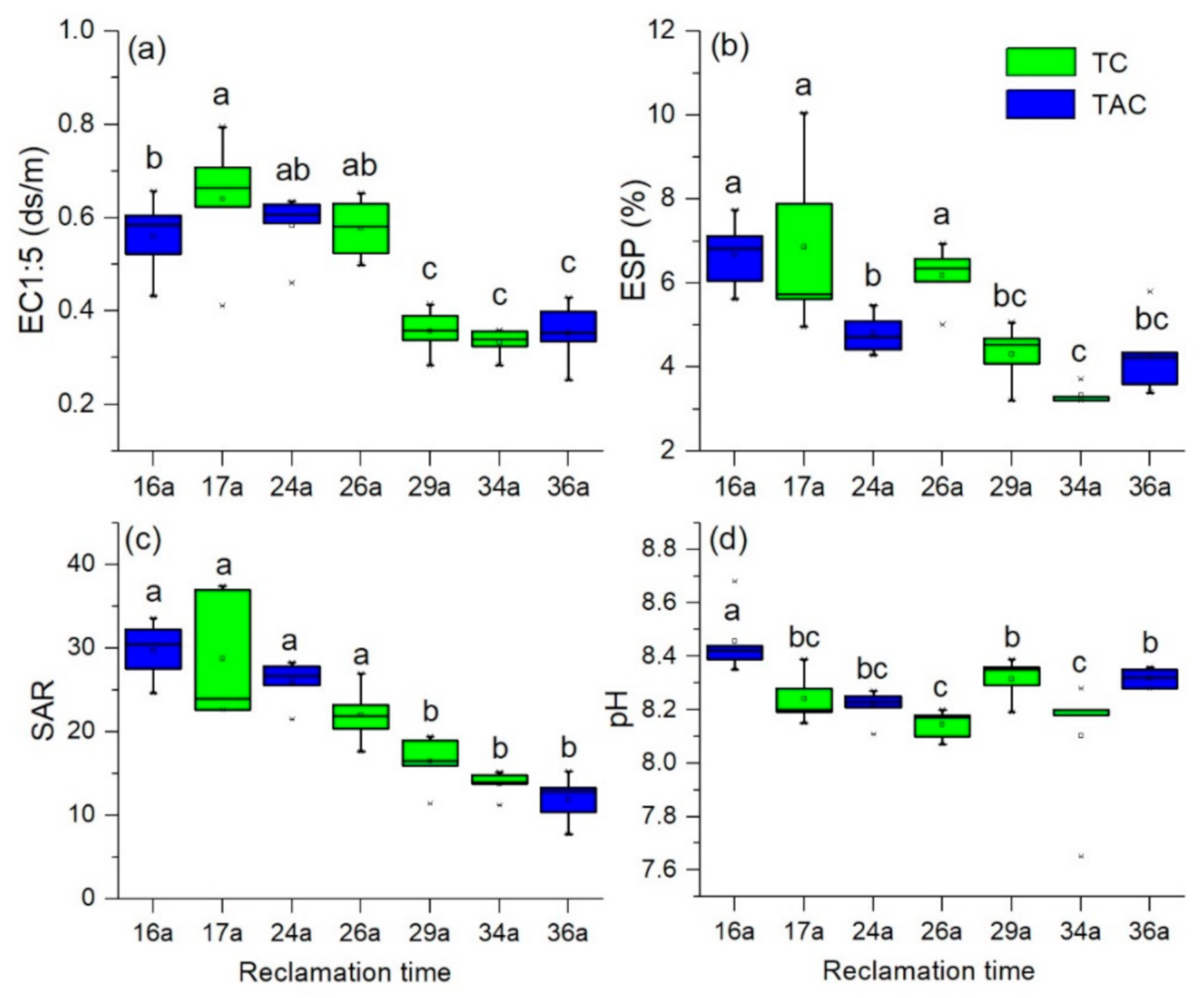
Throughout the reclamation period, few significant changes in soil salinity or sodicity were observed. The EC1:5, SAR, and ESP declined rapidly during the 29 years after reclamation, from 0.58 ds/m, 31.26, and 6.99% to 0.35 ds/m, 16.60, and 4.35%, respectively, and then gradually stabilized (Figure 2a–c). The change trends of EC1:5, SAR, and ESP under different land-use trajectories after reclamation were similar, indicating that both land-use trajectories had great effects on soil desalinization (Figure 2). The pH decreased slightly from 8.47 to 8.1 with time after reclamation, whereas the pH in the reclamation zones with the TAC trajectory was higher (Figure 2d). The pH of soils reclaimed in 1999 was the highest.
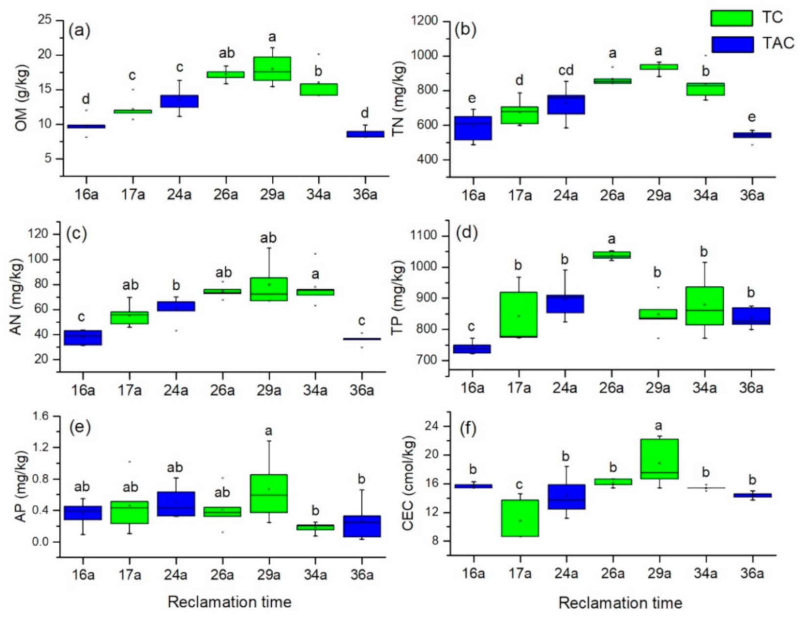
Soil nutrient levels, OM, and CEC also varied significantly following reclamation. Intensive agricultural use caused OM, TN, and AN to increase rapidly during the 29 years after reclamation, from 9.6 g/kg, 571.4 mg/kg, and 37.2 mg/kg to 18.6 g/kg, 994.1 mg/kg, and 79.9 mg/kg, respectively, followed by slight decreases (Figure 3a–c). Land-use trajectories greatly influenced soil OM, TN, and AN (Figure 3a–c). The OM, TN, and AN in the reclamation zones that underwent the TAC trajectory were lower than those values in the reclamation zones that underwent the TC trajectory. The TP ranged between 737.4 mg/kg and 1025.6 mg/kg in the tested soils (Figure 3d). The AP ranged between 0.21 mg/kg and 0.63 mg/kg, which accounted for less than 3% of the TP (Figure 3e). The TP and AP did not change significantly during the reclamation period studied. The soil CEC increased rapidly during the 29 years after reclamation, from 15.6 cmol/kg to 19.58 cmol/kg, and then decreased slightly (Figure 3f). The soil CEC in the reclamation zones that underwent the TC trajectory had less variation than that the soil CEC in the reclamation zones that underwent the TAC trajectory.
Table 2 shows the variation of soil particle size ratios, Al2O3, SiO2, CaO, and Fe2O3 content in different reclamation zones. In the reclamation zones studied, the soil particle size ratio was not significantly correlated with the time since reclamation. Among zones G, E, and A which underwent the TAC trajectory, soil sand ratio in zone G was higher than that in zones E and A. Sand ratio of soils in zone F was higher than that in zones D and C. Soil sand ratio in zone B was higher than that in zones D and C, because zone B was located nearly with zones E and F (Figure 1). Soil silt ratio in zone G was lower than that in zones E and A. Silt ratio of soils in zone F was lower than that in zones D and C. Silt ratio of soils in zone B was lower than that in the zones D and C. Soil clay ratios in zones G, C, A and D were higher than that in zones E, F, and B. The differences of Al2O3, SiO2, CaO, and Fe2O3 content in the reclamation zones were slight. The SiO2 content had a negative correlation with the contents of Al2O3, CaO, and Fe2O3.
The relationships among soil physicochemical properties were analyzed by PCA and are shown in Figure 4. There were positive correlations among OM, TN, AN, CEC, silt, TP, and clay, while EC1:5 was positively correlated with sand, SAR and ESP. OM, TN, AN, CEC, silt, TP, and clay were negatively correlated with EC1:5, SAR and ESP. AP showed fewer correlations with other soil properties. The cluster of soil sampling sites with 16, 17, 29, and 34 years since reclamation was pronounced, indicating a clear dominant effect of soil physicochemical properties. OM, TN, and AN were the most influential soil physicochemical properties in the reclamation zones, with 29 and 34 years since reclamation, respectively. EC1:5, SAR, and ESP were the most influential soil physicochemical properties in the reclamation zones 16 and 17 years after reclamation.

4. Discussion

4.1. Land-Use Changes after Reclamation

Land-use and land-cover changes influence global and regional sustainability. The central challenge is how to preserve ecosystems and services that they provide us while enhancing food production [28]. The global decline in estuarine and coastal ecosystems is affecting a number of critical benefits or ecosystem services [29]. Many salt marshes in coastal areas have been reclaimed for port construction and industrial use [1], and urbanization and industrialization are key drivers of these land-use changes in coastal areas. Jiangsu Coast is the most important muddy coast in China and has progressed rapidly in the past hundreds of years [30]. To find space for food production, the Jiangsu government in China was converting its large-scale coastal wetlands to cropland through large-scale reclamation [5]. The major LULC changes in the reclaimed coastal land occur among tidal land, aquaculture ponds and cropland in the mid-eastern coastal area. Due to the high salinity and sodicity of reclaimed soils and the lack of saline soil improvement technology, many coastal wetlands reclaimed in the 1970s were first transferred to aquaculture ponds and then to cropland. Coastal wetlands reclaimed in the 1980s were directly converted to cropland for food production. Some of them fell in a short period after reclamation because of a lack of investment in preparation for cultivation. Coastal wetlands reclaimed after 1990 were first transferred into aquaculture ponds due to the high profit of aquaculture and the high salinity and sodicity of reclaimed soils, which was consistent with other studies [25,31]. Some of them were also directly converted to croplands with improvements in saline and sodic soils, which were subsidized by the national and local governments. With the desalinization and cultivation project, rice and wheat production with approximately 9000 kg/ha and 6000 kg/ha in the reclaimed tidal flat was considerable. Although the cropland use at the reclaimed tidal land brought a large amount of food, the loss of ecosystem services should be worth heeding [32]. Meanwhile, nonpoint agricultural source pollution and water pollution from aquaculture ponds should be monitored regularly.

4.2. Changes in Soil Physicochemical Properties after Reclamation

The uniformity of soil parent materials is important in soil chronosequences [33]. In this study, the similar values of Al2O3, SiO2, CaO, and Fe2O3 among the sites studied indicated that the sediments that formed the sites studied are comparable, and this method of evaluating the comparability of sediments has been used in other coastal soils [6]. After reclamation, the main soil-forming processes are desalinization, dealkalization, and nutrient accumulation [6,17,33,34]. Rapid desalinization and dealkalization in the study area are promoted by the high annual precipitation, approximately 1028 mm [35], and the drainage water that is brought to the study area through irrigation canals and ditches. Rapid desalinization and dealkalization were indicated by the significant decreases in EC1:5, ESP, and SAR after reclamation, which are consistent with those in Hangzhou Bay and the Bohai Rim in China [6,36]. Generally, the pH gradually decreased after reclamation due to desalinization and dealkalization, which has been observed in other studies [15,36,37]. However, the pH sometimes increased because of the dissolution of calcium carbonate in soils, which was caused by the decrease in Ca2+ and the increase in HCO3 in soils during desalinization [38].
The accumulation of nutrients in reclaimed soils is essential for agricultural cultivation [34]. The soil OM content in bare tidal flats is too low to support crop growth [34,35,39]. With plant residue incorporation, fertilization and field management practices, the soil OM gradually increased to 16 g/kg and tended to remain stable; this trend has been observed in other studies [33,34,40,41]. In addition, the soil OM could increase to a higher stable level with long-term cultivation [35]. Some studies also found that soil organic carbon levels decreased sharply after reclamation, suggesting high organic carbon content before reclamation and a high organic carbon decomposition rate [36]. Nitrogen is an important nutrient for crop growth, and nitrogen levels tend to increase after reclamation [34]. Decreased N levels during the time since reclamation have been reported [12,36]. However, in our study, TN and AN gradually increased with time since reclamation despite plant uptake, ammonia nitrogen loss and runoff, and these trends have been observed in other studies [6,34]. This phenomenon occurs because farmers use large amounts of nitrogen fertilizer during agricultural cultivation. Soil OM, TN and AN affect soil-extracellular enzyme activities, which control soil carbon turnover and nutrient cycling [42,43]. Unlike OM, TN, and AN, there were no significant variations in TP and AP after reclamation. Phosphorus has low mobility and easily becomes fixed in the soil [36,44]. These soils contain high levels of Ca, and a large portion of the P was likely precipitated as low-solubility Ca phosphates [6,7]. In another study, after reclamation, soil Ca phosphates increased from 8.4% to 32.9% [7]. The high TP content in this study must therefore be considered a result of excess fertilizer application. Soil CEC is an important factor in soil productivity [44]. After coastal reclamation, the soil CEC gradually increased due to long-term cultivation. There were no significant differences in soil CEC among sites that were used as aquaculture ponds. Some studies have shown that reclaimed soils reach equilibrium CEC values that are not related to their initial CEC values but are likely related to the mineralogy of the soil [44]. Soil organic carbon can also increase the CEC of the soil [44].
Different land-use types play different roles in soil evolution after coastal reclamation. Understanding these roles provides a basis for decision-making regarding the management of land-use patterns in coastal reclamation areas. The main soil-forming processes, i.e., soil desalinization, dealkalization, and nutrient accumulation, are greatly influenced by land uses. Aquaculture ponds created in reclaimed land can promote rapid soil desalinization and dealkalization through freshwater leaching [12,13,35]. The aquaculture ponds in this study also resulted in high soil pH levels due to the low carbon content in the soils and the historical usage of lime; this result is consistent with the results of other studies [15,45,46]. However, the creation of aquaculture ponds did not lead to the incorporation of residues into soils and therefore did not promote soil nutrient enrichment [12]. The longer the aquaculture ponds had been in existence, the lower the soil salinity and soil nutrient status became. Unlike aquaculture pond creation, land cultivation leads smoothly to soil desalinization and dealkalization [6,12]. Moreover, cultivation can increase the level of soil nutrients [12,33]. The longer the duration of cultivation was, the lower the soil salinity and the higher the soil nutrient status became. Shrimp farming leads to soil degradation and threatens the sustainability of village rice ecosystems [31]. The evolution of soil properties after reclamation also varied greatly between the different modes of cultivation in the study area (i.e., paddy farming and dry farming) due to the aerobic or anaerobic conditions created by the cultivation mode. Paddy rice farming not only rapidly decreases soil salinity but also enriches soil organic matter [33,34]. There are still a range of limitations that need to be addressed. Because the croplands were cultivated only by farmers, we focused on the effects of the time and not reclamation and land-use trajectories on soil evolution. After the diversification of agricultural business entities in this coastal region, future research should consider the influences of different farming activities on soil evolution.

4.3. Implications for Managing Soils Reclaimed from Coastal Wetlands

In summary, approximately 30 years of cultivation on reclaimed coastal tidal flats promoted a positive evolution in soil conditions, as shown by the low salinity and sodicity, nearly neutral pH, and high levels of OM and other soil nutrients. In addition, the reclaimed cultivation area mitigated population pressure on the food supply (i.e., by producing rice, wheat, and rape). In the initial stage (approximately 10 years) of reclamation, reclaimed lands usually develop into aquaculture ponds due to the high soil salinity level, which is higher than the salinity tolerance of most crops. Then, the reclaimed land could gradually be cultivated with rain-fed crops and aquatic crops. We found that the period of approximately 30 to 40 years since reclamation was the transition phase for soil, which is in agreement with many other studies [4,12,13,14,33]. High soil salinity and sodicity and low soil fertility may be common problems for reclaimed coastal lands. Due to their rapid desalinization ability, aquaculture ponds were developed on the reclaimed lands at the initial stage of reclamation. However, given the importance of soil organic carbon to soil fertility, newly reclaimed saline soils should be managed with the goal of increasing their soil organic matter content. Therefore, certain land uses, i.e., aquaculture ponds, should be discontinued, despite their high profitability, since they are not beneficial to soil nutrient enrichment. Furthermore, such soils might require the relatively heavy use of chemical fertilizers containing N, P, and K. Due to the risks of seawater eutrophication, it is necessary to monitor the nutrient status of ditches and canals in reclaimed areas.

5. Conclusions

The coastal reclaimed soils showed a prominent pattern of soil evolution during the period of approximately 30 years since reclamation. The major land-use changes in the reclaimed area occur among tidal land, aquaculture ponds, and cropland. The main changes in the soil physicochemical properties included rapid desalinization, dealkalization, soil organic matter accumulation, and an increase in soil nutrients. Notably, aquaculture ponds were superior to cultivated land in decreasing soil salinity but inferior in soil nutrient accumulation. The use of aquaculture ponds should be correspondingly reduced, despite their high profitability. In the future, more attention should be given to the environmental effects of agricultural cultivation in the reclaimed coastal area.

Author Contributions

Conceptualization, Y.X., L.P.; funding acquisition, Y.X., M.Z. (Ming Zhu); investigation, M.Z. (Meng Zhang), X.B.; writing—original draft preparation, Y.X.; writing—review and editing: Y.X., R.Z., X.X., Y.W. All authors have read and agreed to the published version of the manuscript.

Funding

This study was supported by the Natural Science Foundation of China (NSFC) (No. 41701609, 41230751), Open Foundation of Key Laboratory of Coastal Zone Exploitation and Protection, Ministry of Land and Resource (No. 2017CZEPK09), and The Project of Mass Entrepreneurship and Innovation in Jiangsu Province (No. 491911206).

Institutional Review Board Statement

Not applicable.

Informed Consent Statement

Not applicable.

Data Availability Statement

The data presented in this study are available on request from the corresponding author.

Acknowledgments

The authors are grateful to the Department of Natural and Resources of Dafeng and Sheyang County for providing more help with our soil sample collection.

Conflicts of Interest

The authors declare no conflict of interest.

References

  1. Bi, X.L.; Liu, F.Q.; Pan, X.B. Coastal projects in China: From reclamation to restoration. Environ. Sci. Technol. 2012, 46, 4691–4692. [Google Scholar]
  2. Yang, W.; Sun, T.; Yang, Z.F. Effect of activities associated with coastal reclamation on the macrobenthos community in coastal wetlands of the Yellow River Delta, China: A literature review and systematic assessment. Ocean. Coast. Manag. 2016, 129, 1–9. [Google Scholar]
  3. Xu, C.Y.; Pu, L.J.; Zhu, M.; Chen, X.J.; Wang, X.H.; Xie, X.F. Ecological security and ecosystem services in response to land use change in the coastal area of Jiangsu, China. Sustainability 2016, 8, 816. [Google Scholar]
  4. Li, J.G.; Pu, L.J.; Zhu, M.; Zhang, J.; Li, P.; Dai, X.; Xu, Y.; Liu, L.L. Evolution of soil properties following reclamation in coastal areas: A review. Geoderma 2014, 226, 130–139. [Google Scholar]
  5. Cai, F.F.; Vliet, J.V.; Verburg, P.H.; Pu, L.J. Land use change and farmer behavior in reclaimed land in the middle Jiangsu coast, China. Ocean. Coast. Manag. 2017, 137, 107–117. [Google Scholar]
  6. Iost, S.; Landgraf, D.; Makeschin, F. Chemical soil properties of reclaimed marsh soil from Zhejiang Province PR China. Geoderma 2007, 142, 245–250. [Google Scholar]
  7. Yin, A.J.; Gao, C.; Zhang, M.; Wu, P.B.; Yang, X.H. Rapid changes in phosphorus species in soils developed on reclaimed tidal flat sediments. Geoderma 2017, 307, 46–53. [Google Scholar]
  8. Zhang, H.; Yin, A.J.; Yang, X.H.; Wu, P.B.; Fan, M.M.; Wu, J.T.; Zhang, M.; Gao, C. Changes in surface soil organic/inorganic carbon concentrations and their driving forces in reclaimed coastal tidal flats. Geoderma 2019, 352, 150–159. [Google Scholar]
  9. Lambin, E.F.; Geist, H.J. Land-Use and Land-Cover Change: Local Processes and Global Impacts; Springer Science & Business Media: Berlin/Heidelberg, Germany, 2008. [Google Scholar]
  10. Abdullah, A.M.; Masrur, A.; Adnan, M.S.G.; Al Baky, M.A.; Hassan, Q.K.; Dewan, A. Spatio-temporal patterns of land use/land cover change in the heterogeneous coastal region of Bangladesh between 1990 and 2017. Remote Sens. 2019, 11, 26. [Google Scholar]
  11. Mihelič, R.; Pečnik, J.; Glavan, M.; Pintar, M. Impact of sustainable land management practices on soil properties: Example of organic and integrated agricultural management. Land 2021, 10, 8. [Google Scholar]
  12. Sun, Y.G.; Li, X.Z.; Mander, Ü.; He, Y.L.; Jia, Y.; Ma, Z.G.; Guo, W.Y.; Xin, Z.J. Effect of reclamation time and land use on soil properties in Changjiang River Estuary, China. Chin. Geogr. Sci. 2011, 21, 403–416. [Google Scholar]
  13. Wang, G.B.; Zhao, X.L.; Wang, M.H.; Ruan, H.H.; Xu, C.B.; Xu, Y.M. Effects of land use change on soil readily oxidizable carbon in a coastal area of northern Jiangsu Province, East China. Chin. J. Appl. Ecol. 2013, 24, 921–926. (In Chinease) [Google Scholar]
  14. Li, X.Z.; Sun, Y.G.; Mander, Ü.; He, Y.L. Effects of land use intensity on soil nutrient distribution after reclamation in an estuary landscape. Landsc. Ecol. 2013, 28, 699–707. [Google Scholar]
  15. Bai, J.; Xiao, R.; Zhang, K.; Gao, H.; Cui, B.; Liu, X. Soil organic carbon as affected by land use in young and old reclaimed regions of a coastal estuary wetland, China. Soil Use Manag. 2013, 29, 57–64. [Google Scholar]
  16. Meng, Q.F.; Yang, J.S.; Yao, R.J.; Liu, G.M. Soil quality in east coastal region of China as related to different land use types. J. Soils Sediments 2013, 13, 664–676. [Google Scholar]
  17. Xie, X.F.; Pu, L.J.; Zhu, M.; Wu, T.; Xu, Y. Spatio-temporal variability of soil salinity and sodicity in agricultural reclaimed coastal wetlands, Eastern China. Arch. Agron. Soil Sci. 2019, 66, 1–12. [Google Scholar]
  18. Xu, Y.; Pu, L.J.; Zhu, M.; Li, J.G.; Zhang, M.; Li, P.; Zhang, J. Spatial variation of soil salinity in the coastal reclamation area, eastern China. J. Coast. Res. 2014, 30, 411–417. [Google Scholar]
  19. Yin, A.J.; Zhang, M.; Gao, C.; Yang, X.H.; Xu, Y.; Wu, P.B.; Zhang, H. Salinity evolution of coastal soils following reclamation and intensive usage, Eastern China. Environ. Earth Sci. 2016, 75, 1281. [Google Scholar]
  20. Ziter, C.; Turner, M.G. Current and historical land use influence soil-based ecosystem services in an urban landscape. Ecol. Appl. 2018, 28, 643–654. [Google Scholar]
  21. Yesilonis, I.; Szlavecz, K.; Pouyat, R.; Whigham, D.; Xia, L. Historical land use and stand age effects on forest soil properties in the Mid-Atlantic US. For. Ecol. Manag. 2016, 370, 83–92. [Google Scholar]
  22. Bao, J.L.; Gao, S.; Ge, J.X. Salt and wetland: Traditional development landscape, land use changes and environmental adaptation on the central Jiangsu Coast, China. Wetlands 2019, 39, 1089–1102. [Google Scholar] [CrossRef]
  23. Zhang, R.S. Suspended sediment transport processes on tidal mudflat in Jiangsu Province, China. Estuar. Coast. Shelf Sci. 1992, 35, 225–233. [Google Scholar]
  24. Wu, H.; Shen, J.; Zhu, J.L.; Zhang, J.; Li, L. Characteristics of the Changjiang plume and its extension along the Jiangsu Coast. Cont. Shelf. Res. 2014, 76, 108–123. [Google Scholar] [CrossRef]
  25. Xie, X.F.; Pu, L.J.; Zhu, M.; Wu, T.; Xu, Y.; Wang, X.H. Effect of long-term reclamation on soil quality in agricultural reclaimed coastal saline soil, Eastern China. J. Soil Sediment 2020, 20, 3909–3920. [Google Scholar] [CrossRef]
  26. Lu, K.R. Methods of Soil Agrochemistry; Agricultural Science and Technology Press: Beijing, China, 2000. (In Chinease) [Google Scholar]
  27. Burt, R. Soil Survey Field and Laboratory Methods Manual; Soil Survey Investigations Report 51; Version 1.0. USDA-NRCS; National Soil Survey Center: Lincoln, NE, USA, 2009.
  28. Lambin, E.F.; Meyfroidt, P. Global land use change, economic globalization, and the looming land scarcity. Proc. Natl. Acad. Sci. USA 2011, 108, 3465–3472. [Google Scholar] [CrossRef] [Green Version]
  29. Barbier, E.B.; Hacker, S.D.; Kennedy, C.; Koch, E.W.; Stier, A.C.; Silliman, B.R. The value of estuarine and coastal ecosystem services. Ecol. Monogr. 2011, 81, 169–193. [Google Scholar] [CrossRef]
  30. Li, J.; Gao, S.; Wang, Y.P. Invading cord grass vegetation changes analyzed from Landsat-TM imageries: A case study from the Wanggang area, Jiangsu coast, eastern China. Acta Oceanol. Sin. 2010, 29, 26–37. [Google Scholar] [CrossRef]
  31. Ali, A.M.S. Rice to shrimp: Land use/land cover changes and soil degradation in Southwestern Bangladesh. Land Use Policy 2006, 23, 421–435. [Google Scholar] [CrossRef]
  32. Zhang, R.S.; Pu, L.J.; Li, J.G.; Zhang, J.; Xu, Y. Landscape ecological security response to land use change in the tidal flat reclamation zone, China. Environ. Monit. Assess. 2016, 188, 1–10. [Google Scholar] [CrossRef]
  33. Cui, J.; Liu, C.; Li, Z.L.; Wang, L.; Chen, X.F.; Ye, Z.Z.; Fang, C.M. Long-term changes in topsoil chemical properties under centuries of cultivation after reclamation of coastal wetlands in the Yangtze Estuary, China. Soil Tillage Res. 2012, 123, 50–60. [Google Scholar] [CrossRef]
  34. Zhang, H.; Wu, P.B.; Yin, A.J.; Yang, X.H.; Zhang, X.; Zhang, M.; Gao, C. Organic carbon and total nitrogen dynamics of reclaimed soils following intensive agricultural use in eastern China. Agric. Ecosyst. Environ. 2016, 235, 193–203. [Google Scholar] [CrossRef]
  35. Xie, X.F.; Pu, L.J.; Zhu, M.; Xu, Y.; Wang, X.H. Linkage between soil salinization indicators and physicochemical properties in a long-term intensive agricultural coastal reclamation area, Eastern China. J. Soils Sediments 2019, 19, 1–9. [Google Scholar] [CrossRef]
  36. Wang, Y.D.; Wang, Z.L.; Feng, X.P.; Guo, C.C.; Chen, Q. Long-term effect of agricultural reclamation on soil chemical properties of a coastal saline marsh in Bohai Rim, Northern China. PLoS ONE 2014, 9, e93727. [Google Scholar] [CrossRef] [PubMed]
  37. Xie, X.F.; Pu, L.J.; Wang, Q.Q.; Zhu, M.; Xu, Y.; Zhang, M. Response of soil physicochemical properties and enzyme activities to long-term reclamation of coastal saline soil, Eastern China. Sci. Total Environ. 2017, 607, 1419. [Google Scholar] [CrossRef] [PubMed]
  38. Yin, Y.H.; Chen, B.B. Discussion on the increase reason of saline soil pH following desalinization in the Jiangsu Province. J. Soil Sci. 1991, 22, 5–7. (In Chinese) [Google Scholar]
  39. Li, J.G.; Yang, W.H.; Li, Q.; Pu, L.J.; Xu, Y.; Zhang, Z.Q.; Liu, L.L. Effect of reclamation on soil organic carbon pools in coastal areas of eastern China. Front. Earth Sci. 2018, 12, 339–348. [Google Scholar] [CrossRef]
  40. Deng, X.F.; Zhan, Y.; Wang, F.; Ma, W.Z.; Ren, Z.Q.; Chen, X.J.; Qin, F.J.; Long, W.L.; Zhu, Z.L.; Lv, X.N. Soil organic carbon of an intensively reclaimed region in China: Current status and carbon sequestration potential. Sci. Total Environ. 2016, 565, 539–546. [Google Scholar] [CrossRef]
  41. Xu, Y.; Pu, L.J.; Liao, Q.L.; Zhu, M.; Yu, X.; Mao, T.Y.; Xu, C.X. Spatial Variation of Soil Organic Carbon and Total Nitrogen in the Coastal Area of Mid-Eastern China. Int. J. Environ. Res. Public Health 2017, 14, 780. [Google Scholar] [CrossRef] [Green Version]
  42. Xie, X.F.; Pu, L.J.; Zhu, M.; Meadows, M.; Sun, L.C.; Wu, T.; Bu, X.G.; Xu, Y. Differential effects of various reclamation treatments on soil characteristics: An experimental study of newly reclaimed tidal mudflats on the east China coast. Sci. Total Environ. 2021, 768, 144996. [Google Scholar] [CrossRef]
  43. Xie, X.F.; Wu, T.; Zhu, M.; Jiang, G.J.; Xu, Y.; Wang, X.H.; Pu, L.J. Comparison of random forest and multiple linear regression models for estimation of soil extracellular enzyme activities in agricultural reclaimed coastal saline land. Ecol. Indic. 2021, 120, 106925. [Google Scholar] [CrossRef]
  44. Saikh, H.; Varadachari, C.; Ghosh, K. Effects of deforestation and cultivation on soil CEC and contents of exchangeable bases: A case study in Simlipal National Park, India. Plant Soil 1998, 204, 175–181. [Google Scholar] [CrossRef]
  45. Warman, P.R.; Harnish, B.; Muizelaar, T. A lime requirement test for maritime Canada, and response time and effect of liming source on soil ph. Commun. Soil Sci. Plan. 2008, 27, 1427–1436. [Google Scholar] [CrossRef]
  46. Wang, W.J.; Qiu, L.; Zu, Y.G.; Su, D.X.; An, J.; Wang, H.G.; Zheng, G.Y.; Sun, W.; Chen, X.Q. Changes in soil organic carbon, nitrogen, pH and bulk density with the development of larch (Larix gmelinii) plantations in China. Glob. Chang. Biol. 2011, 17, 2657–2676. [Google Scholar]
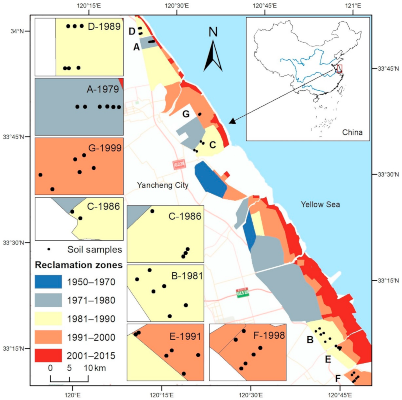
Figure 1. Location of the study area and soil sampling points.
Land 10 00142 g001
Figure 2. Soil EC1:5 (a), exchange sodium percentage (ESP) (b), sodium adsorption ratio (SAR) (c) and pH (d) in the different reclamation zones. Values represent the means ± Standard Deviations (SDs). Different letters indicate significant differences among different reclamation years (LSD, p < 0.05). 16a, 17a, 24a, 26a, 29a, 34a and 36a indicate reclamation years of 16, 17, 24, 26, 29, 34 and 36, respectively.
Land 10 00142 g002
Figure 3. Soil organic matter (OM) (a), total nitrogen (TN) (b), alkaline hydrolyzable nitrogen (AN) (c), total phosphorus (TP) (d), available phosphorus (AP) (e), and cation exchange capacity (CEC) (f) in different reclamation zones. Values represent the means ± SDs. Different letters indicate significant differences among different reclamation years (LSD, p < 0.05). 16a, 17a, 24a, 26a, 29a, 34a and 36a indicate reclamation years of 16, 17, 24, 26, 29, 34 and 36, respectively.
Land 10 00142 g003
Figure 4. Ordination biplot of the PCA of soil physicochemical properties. The first two axes accounted for 76.71% of the variability in the dataset (n = 42).
Land 10 00142 g004
Table 1. Land-use trajectory from 1985 to 2015.
ZoneLand-Use Trajectory from 1985 to 2015Reclamation TimeType
G-1999T→T→T→A→A→A→A→C→C→C→C16aTAC
F-1998T→T→T→C→C→C→C→C→C→C→C17aTC
E-1991T→T→A→A→A→A→C→C→C→C→C24aTAC
D-1989T→T→C→C→C→C→C→C→C→C→C26aTC
C-1986T→T→T→T→T→T→C→C→C→C→C29aTC
B-1981T→C→C→C→C→C→C→C→C→C→C34aTC
A-1979A→A→A→A→A→A→A→C→C→C→C36aTAC
Note: The different points in time of land-use trajectory from 1985 to 2015 were 1985, 1991, 1996, 2000, 2002, 2005, 2008, 2010, 2012, 2014 and 2015. A-1979 represents the zone A reclaimed in 1979. A represents aquaculture pond; T represents tidal land; C represents cropland; 16a, 17a, 24a, 26a, 29a, 34a and 36a indicate reclamation years of 16, 17, 24, 26, 29, 34 and 36, respectively. Land-use trajectory 1 (TAC): Tidal land (T)→Aquaculture pond (A)→Cropland (C); Land-use trajectory 2 (TC): Tidal land (T)→Cropland (C). Zone A was reclaimed in 1979; however, the land-use trajectories were from 1985 to 2015. Although there was no tidal land in the above table, the type of land-use trajectory was TAC.
Table 2. Soil particle size ratios, Al2O3, SiO2, CaO, and Fe2O3 content in different reclamation zones. Values represent the means ± SDs. Different letters indicate significant differences among different reclamation years (LSD, p < 0.05).
ZonesGFEDCBA
Time16a17a24a26a29a34a36a
Sand (%)53.8 ± 3.9 b59.9 ± 6.4 a53.2 ± 5.5 b50.3 ± 3.2 bc44.7 ± 8.2 c53.4 ± 2.0 b50.0 ± 3.6 bc
Silt (%)38.2 ± 3.3 bc34.5 ± 5.6 c40.7 ± 5.9 b42.1 ± 2.9 b48.0 ± 8.0 a40.2 ± 2.2 b42.5 ± 3.1 ab
Clay (%)8.0 ± 0.6 a5.6 ± 0.9 c6.1 ± 0.7 bc7.6 ± 0.5 a7.4 ± 0.4 a6.4 ± 0.7 b7.5 ± 0.8 a
SiO2 (%)62.1 ± 0.6 c65.5 ± 1.3 a63.7 ± 1.3 b62.9 ± 0.8 bc61.2 ± 1.8 c64.9 ± 1.0 ab61.9 ± 0.3 c
Al2O3 (%)11.7 ± 0.1ab10.9 ± 0.3 c11.2 ± 0.3 bc11.2 ± 0.2 bc12.1 ± 0.7 a10.9 ± 0.2 c11.5 ± 0.1 b
CaO (%)6.1 ± 0.1 b5.3 ± 0.4 d5.7 ± 0.3 c6.0 ± 0.1 b5.9 ± 0.1 bc5.4 ± 0.2 d6.4 ± 0.1 a
Fe2O3 (%)4.3 ± 0.0 b3.8 ± 0.2 d4.0 ± 0.2 c4.2 ± 0.1 bc4.5 ± 0.4 a4.0 ± 0.1 cd4.3 ± 0.1 ab
Note: The soil particle sizes of clay, silt and sand are < 0.002 mm, 0.002–0.05 mm, and 0.05–2 mm, respectively [27].
Publisher’s Note: MDPI stays neutral with regard to jurisdictional claims in published maps and institutional affiliations.