Article

Vulnerabilities and Threats to Natural Forest Regrowth: Land Tenure Reform, Land Markets, Pasturelands, Plantations, and Urbanization in Indigenous Communities in Mexico

1
Instituto de Investigaciones Sociales, Universidad Nacional Autónoma de México, Mexico City 04510, CP, Mexico
2
Facultad de Ciencias Agropecuarias y Forestales, Universidad de La Frontera, Temuco 4811230, Chile
3
Facultad de Ciencias Forestales, Universidad de Concepción, Concepción 4070374, Chile
4
Natura y Ecosistemas Mexicanos, A.C., Mexico City 01000, Mexico
5
Facultad de Ciencias, Universidad Nacional Autónoma de México, Mexico City 04510, CP, Mexico
*
Author to whom correspondence should be addressed.
Land 2021, 10(12), 1340; https://doi.org/10.3390/land10121340
Submission received: 11 October 2021 / Revised: 25 November 2021 / Accepted: 25 November 2021 / Published: 5 December 2021
(This article belongs to the Special Issue The Governance of Natural Forest Regrowth as a Restoration Option)

Abstract

:
Despite the economic and social costs of national and international efforts to restore millions of hectares of deforested and degraded landscapes, results have not met expectations due to land tenure conflicts, land-use transformation, and top-down decision-making policies. Privatization of land, expansion of cattle raising, plantations, and urbanization have created an increasingly competitive land market, dispossessing local communities and threatening forest conservation and regeneration. In contrast to significant investments in reforestation, natural regrowth, which could contribute to landscape regeneration, has not been sufficiently promoted by national governments. This study analyzes socio-ecological and economic vulnerabilities of indigenous and other peasant communities in the Mexican states of Veracruz, Chiapas, and Morelos related to the inclusion of natural regeneration in their forest cycles. While these communities are located within protected areas (Los Tuxtlas Biosphere Reserve, Montes Azules Biosphere Reserve, El Tepozteco National Park, and Chichinautzin Biological Corridor), various threats and vulnerabilities impede natural regeneration. Although landscape restoration involves complex political, economic, and social relationships and decisions by a variety of stakeholders, we focus on communities’ vulnerable land rights and the impacts of privatization on changes in land use and forest conservation. We conclude that the social, economic, political, and environmental vulnerabilities of the study communities threaten natural regeneration, and we explore necessary changes for incorporating this process in landscape restoration.

1. Introduction

1.1. Vulnerabilities and Threats to Forest Regrowth

Many international and national initiatives—such as the Bonn Challenge, the 20/20 Initiative in Latin America and the Caribbean, and the AFR100 Initiative involving 30 African countries—aim to restore deforested and degraded landscapes. Funders of such initiatives include governments of countries of the global north; international NGOs (IUCN, WRI, WWF); global programs such as REDD+; and increasingly, global corporations claiming to promote a green economy. Despite economic and social investment, these initiatives have not achieved their goals of restoring millions of hectares and reducing deforestation due to a variety of socio-environmental and political factors [1,2,3,4,5]. Heads of environmental and agricultural ministries involved in these initiatives have blamed this on drought, food security crises, and unproductive agricultural practices [6,7], failing to acknowledge the impact of expansion of cattle-raising, agroindustrial plantations, urbanization, and extractive mining and oil companies. Such industries have created a market for land, dispossessing indigenous and peasant communities [8,9,10,11]. As a result, regeneration in these landscapes is threatened by communities’ loss of land tenure rights, land tenure conflicts, land market pressures, commercial plantations, livestock expansion, illegal logging, and top-down environmental and agricultural policies [9,10,12,13,14,15,16].
Achieving goals of restoring millions of hectares during the UN Decade on Ecosystem Restoration (2021–2030) will not only be very costly but also highly uncertain due to the opportunity cost of land, land-use change, forest fires, dense human populations in some regions, rural poverty, biophysical and ecological limitations, and challenges to food security [5]. Despite investment in reforestation, many national governments and international institutions have failed to promote landscape regeneration through natural regrowth [4,5,17], mainly due to its low political impact as compared to that of reforestation. While agricultural land under transition to forest is likely to recover its structural properties, species composition, and socio-ecological functions, studies suggest that transition to mature secondary forest requires at least 50 years, depending on environmental conditions [18,19,20,21]. Natural forest regeneration is part of the cycle of traditional agricultural systems involving rotation between crops and forest. Until the 1990s, regeneration and cultivation constituted an integrated system [22,23,24,25]. Nevertheless, social, economic, political, and environmental vulnerabilities1 of indigenous communities, as well as increasing intensification of land use, have hindered natural regrowth.
The concept of vulnerability is key to understanding the multidimensionality of regeneration, regrowth, and reforestation, as each of these processes involves environmental, social, economic, political, and cultural threats. While initially applied to hazards and disasters [26,27], this concept provides a theoretical framework for understanding people’s relationships to their environment, taking into account social forces, power relations, institutions, and cultural values that promote or impede conservation, reforestation, and natural regeneration. Eleven forms of vulnerability—biological, ecological, physical, economic, social, political, technical, ideological, cultural, educational, and institutional vulnerability— have been identified [28], providing a framework for analyzing chains of causality [29] that foster natural regeneration. Despite these threats and vulnerabilities, forests are regenerating in many countries, resulting in multi-functional landscapes [1,4,30,31], which not only provide economic benefits but are also restructuring cultural relationships within indigenous and peasant communities. Currently, there is a need for national policies to confront multiple interrelated social, economic, and political threats to natural regeneration in rural communities [3,4,5].
In Mexico, the combination of agricultural intensification, expansion of cattle raising, transformation of land tenure regimes, urbanization fostered by tourism, and top-down forest policies have contributed to the inhibition of long-term forest regrowth and landscape regeneration [15,32]. Initial evaluation indicates that 3,149,631 ha were reforested throughout Mexico from 2001 to 2015 [33], although long-term monitoring of plant survival and growth is lacking. However, 3,208,011 ha were deforested during the same period [34]. Considering that only 60% of reforestation lasts more than 10 years, deforestation is winning the battle. Reports on natural regeneration have been sporadic and are not easily available [35,36].
Understanding rural vulnerabilities and threats—including food insecurity; rural migration; sale of ejido and communal land2; poverty and socio-economic inequity; and land-cover change to pasture, commercial monocultures, and urbanization—requires a multiscale analysis and a multi-situated ethnography [37]. We analyze three case studies to illustrate vulnerabilities that often result from national policies and globalization through markets and capital flows, which are common in indigenous Mexican and other peasant communities. We focus on socio-cultural, economic, and political vulnerabilities and threats that hinder rural communities with contrasting cultural and political contexts and socio-economic pressures from achieving continuous vegetation regrowth and forest regeneration. While the populations of the three case studies were originally indigenous, since the 1950s, they have undergone cultural transformations, as many mestizo rural families have immigrated to these communities and because many community members have migrated to the US or Canada as temporary or permanent workers.

1.2. The 1992 (Counter) Agrarian Reform: A New Land Market

With Mexico’s 1992 Counter-Agrarian Reform, Article 27 of the Constitution was reformed. The 1993 Agrarian Law allowed for private ownership and sale of previously collective ejido and communal land [38]. Ejido land had been defined as inalienable, unseizable, indefeasible, non-transmissible, unrentable, and untaxable. Implementation of the Agrarian Law was gradual for the majority of ejidos in Mexico through the “voluntary” Program for Certification of Ejido Rights and Titling of Urban Plots (PROCEDE in Spanish), which promoted demarcation of ejidos and communal land with the supposed aim of providing legal security to land tenure. This led to modifications in land use and property rights, disintegration of peasant cooperatives, and—especially relevant to our study—privatization of forest land in an effort to liberalize and stimulate the rural economy [32,39,40,41,42].
Shortly after the reform was implemented, its social, economic, environmental, and patrimonial impacts were not fully evident. Despite predictions that privatization signaled the end of the ejido, most ejidos did not quickly opt for privatization of common-use land [43]. However, almost 30 years later, it is evident that this counter-reform reversed the post-revolutionary 1917 constitution, which protected peasant land from open market competition, preserved continuity of peasant land, and granted the State—rather than the market—the principal role in regulating economic, political, and social relations of ejidos and communal landholdings, fomenting their development through loans, technical assistance, and provision of agricultural inputs [42,44].
As a prerequisite for signing the 1994 North American Free Trade Agreement (NAFTA), Mexico’s 1992 reform allowed for sale of rural land. While the expected impacts on the land market have taken longer than predicted, the effects of the sale of ejido and communal land have been recently devastating in some regions. Prior to 1992, ejido and communal lands were occasionally sold despite constitutional stipulations; however, purchasers were generally from the same ejido or communal landholding, and sale was approved by the communal or ejido commissioner, and in most cases, it had to be approved by the assembly, thereby providing for community control over land sales.
Until 2010, very few studies addressed changing patterns in forest cover resulting from the counter-reform. However, some studies of the relationship between land tenure and landscape changes [15,16,32] have shown that privatized ejidos tend to have more land being used for agriculture and higher deforestation rates than commonly held ejidos, many of which have furthermore obtained economic benefits through community forest management [32,45]. Nevertheless, the type of land tenure per se is less of a driver of land-use changes than the fragility of institutional arrangements that structure land tenure and the extent of accumulated vulnerabilities in rural communities.

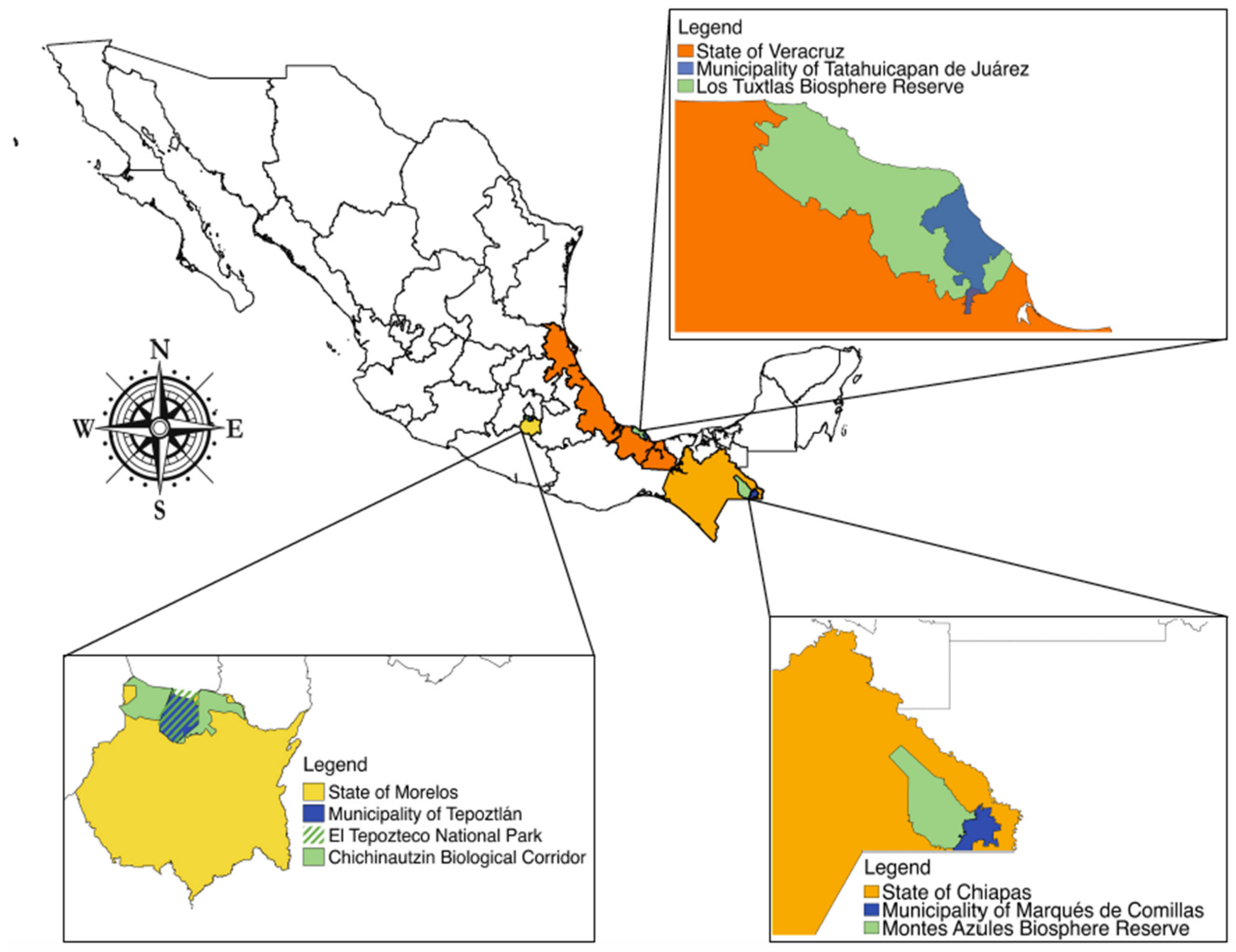
1.3. Case Studies in Veracruz, Chiapas, and Morelos

The first case is the ejido of Tatahuicapan in the municipality of Tatahuicapan de Juárez of southern Veracruz in the Sierra of Santa Marta, which covers approximately 1500 km2 and forms part of the Sierra of Los Tuxtlas (Figure 1). Since pre-Hispanic times, the population was of Popoluca and Nahua origin, but in the 1950s and 1960s, government programs brought waves of mestizo migrants from central Veracruz and other regions of central Mexico [46,47,48]. The municipality’s 62 villages cover 295.8 km2, with a population of 16,369 in 2018 [49]. The ejido of Tatahuicapan, founded in 1966, covers 8361 ha.
Due to the coastal location of the Sierra of Santa Marta; its altitudinal range from sea level to 1700 masl (including the volcanoes of Santa Marta, San Martín Pajapan, and San Martín Tuxtla); and its humid tropical climate (annual average precipitation > 4000 mm), many vegetation types are found, with a predominance of rainforest, cloud forest, and pine-oak forest in various stages of succession. The convergence of two biogeographical regions (Neartic and Neotropical) explains its great biological richness and high plant endemism [50,51]3. For this reason, in 1980, it was declared a Forestry Protection and Wild Fauna Refuge Zone, and in 1998, the Los Tuxtlas Biosphere Reserve.
Largely due to landless mestizo rural migration, international loans, and low maize prices, this former agricultural region transitioned to cattle raising [52,53,54]. In the 1960s, tropical regions of Mexico, including parts of the states of Veracruz and Chiapas, were included in federal programs4 encouraging peasants from central Mexico to settle and clear the land. In the 1970s, Interamerican Development Bank programs promoted livestock raising [46,55,56]. Consequently, cattle raising has become a severe threat to rainforest conservation [46,57].
The second case is the municipality of Marqués de Comillas in eastern Chiapas (Figure 1), whose original inhabitants were mainly of Mayan origin. The region was largely uninhabited until 1967, when the federal government declared over 400,000 ha as a federal property suitable for colonization [58]. A government program by the Echeverría administration (1970–1976) encouraged immigration to occupy Mexico’s southern border region, catalyzing drastic land-cover change [59,60]. The region’s first ejidos were established next to the Lacantún River, bordering the Montes Azules Biosphere Reserve, established in 1978. The population increased rapidly during the 1970s and 1980s [61], as 10,000 peasants, mainly from southern Mexico, settled the area [60,62,63], converting rainforest to agricultural land [61].
The municipality (92,242 ha) currently contains 28 localities, of which only 22 are officially registered [64]. From 2000 to 2020, the population increased from 8580 to 12,892. According to Mexico’s Social Development Policy Council, 92% of the population falls under the poverty level, 80% of whom rely on agriculture [65]. The population increase was the principal driver of deforestation during the settlement period, when forest regrowth was nonexistent. In the mid-1980s, Marqués de Comillas was still practically covered by rainforest [59]. However, during the 1990s, economic factors (e.g., markets) and public policy spurred environmental changes. An unsuccessful Forestry Management Plan led to the sale and distribution of common-use land, further deforestation, and forest fragmentation. The 1994 Program for Direct Agricultural Support (PROCAMPO) provided agricultural subsidies to farmers cultivating at least five hectares, further accelerating the agricultural conversion of secondary vegetation and rainforest. Despite these programs, the Montes Azules Biosphere Reserve still contains Mexico’s largest rainforest.
The third case is the municipality of Tepoztlán in the northern region of the state of Morelos, consisting of eight communities. Most of its territory is protected by either the Tepozteco National Park, created in 1937, or the Chichinautzin Biological Corridor, created in 1988. Tropical dry forest, oak, pine-oak, and pine forests are found along a broad altitudinal gradient (1230–2350 masl).
The communal land of Tepoztlán, which had been taken over by the Oacalco Hacienda, was returned to the eight communities in 1929. However, the entire area of 23,800 ha was given to all comuneros (peasants with legal rights to land), instead of dividing it among each community, resulting in continual conflict, as decision making and information have been concentrated in the municipal seat of Tepoztlán. Although the borders of each community are generally respected, an imbalance of political and economic power arises due to the lack of independent status for each community. This is the case of Amatlán de Quetzalcóatl, which consists of 2610 ha and had a population of 1029 in 2010 and 1312 in 2020. Historically, authorities and individuals from Amatlán have had to negotiate with communal authorities of Tepoztlán under unequal conditions, and funding from government programs has not always been clear and equitable. Changes in land tenure in Amatlán must be sanctioned by the communal commissary of Tepoztlán (which legally represents all communities), as well as municipal authorities.
During most of the 20th century, peasants of all communities of Tepoztlán cultivated their land and worked seasonally in sugar plantations, but the introduction of tourism in the late 1980s significantly transformed the municipal economy.

2. Methods

For several years, the authors have promoted alternative community development according to the principles of participatory action research. Qualitative data were gathered regarding community members’ perceptions of ecological, socio-cultural, and economic transformations related to land-use change.
In Veracruz, from the mid-1990s to 2001, the first author worked with Nahua families to transform extensive cattle raising—which began in the 1950s—into holistic cattle raising, which allows for conservation of patches of successional vegetation and a series of interconnected biological corridors [46,48,54,66,67]. In June and July of 2019, the author and a team of students evaluated long-term and more recent vulnerabilities and threats that communities have faced while trying to conserve the rainforest. For this, 60 structured interviews of ejido members of Tatahuicapan and 15 open interviews with ejido and municipal authorities, teachers, and elders of the community were carried out. Furthermore, focal groups with young people were organized to discuss their community’s future.
The second author has worked in the Lacandona region of Chiapas since 2006, although the relationship with local communities was established several decades ago by a non-governmental organization with which she works. In 2006, she began working with the farmers through an ecological restoration program following a multiscale perspective [68]. On a regional scale, key sites for recovery of biological connectivity were identified. Priority sites for conservation and restoration were selected in workshops with ejido members [69]. Finally, on a plot scale, specific restoration plans were designed according to site characteristics and the willingness of landowners [70,71]. Interviews were carried out with 72 farmers on local climate change, rainforest transformation and restoration, and management practices. Different restoration strategies were implemented and evaluated over the years [72,73]. Ecotourism and handcrafts complemented ecological restoration.
The third author began to work in Amatlán in 2011, when a group of comuneros asked her for advice on establishing a rural nursery and implementing reforestation. Fieldwork was conducted with a group of undergraduate and master’s students to monitor reforestation and to carry out surveys of vegetation [74,75] and birds [76]; environmental education projects [77]; and studies of native species propagation, land-use/land-cover change [78], and agricultural practices [79]. Based on resulting information, environmental education and ecotourism materials were developed. Information on agricultural practices was obtained through interviews with 30 peasants from April 2017 to February 2018. Focal groups were organized to gather information regarding territorial use and public policies [80]. Additional interviews were conducted in August 2021 regarding land tenure rights and community members’ perceptions of abandoned agricultural fields (acahuales) and reforestation programs in the community.

3. Results

3.1. Can New Land Markets, Natural Regeneration, and Community Political Institutions Coexist with the 1992 Agrarian Reform?

As a result of the 1992 Agrarian Reform’s modifications of property rights, in recent years, land sales have increased in the three study areas, impeding natural regeneration of secondary vegetation.
Shortly after the reform, ejido members of Tatahuicapan were pressing for regulation of their land, and little land was sold. Nevertheless, land sales have increased as the ejido has become a commercial center for the Sierra region. In Tatahuicapan, while 486 ejido members were recorded in 1995 [46], the most recent census recorded 767 members [81]. The majority of recent members came from the oil-producing cities of Coatzacoalcos and Minatitlan, Veracruz to raise cattle. Transformation of their plots into pastures has counteracted natural regeneration and maintenance of biological corridors, threatening remaining patches of rainforest and temperate forest in Los Tuxtlas Biosphere Reserve.
Ejido land purchase has involved political and socio-environmental transformation of the ejido. Most recent ejido members do not respect community assembly agreements, nor do they wish to conserve community forests. The ejido Commissioner (interview, July 2019) commented on this political transformation:
“People from Coatzacoalcos are buying the land, and now they are the new ejido members. Having money allows them to pay for two or three plots, and they set the price. Formerly, ejido members were native to here and participated in the assemblies; the majority participated. Forty or 50 were missing, but up to 400 met. Not anymore; not even a fourth of them come. That takes away our strength. If we want to fight to defend our water and our forests, we don’t have the strength anymore, with so many people from elsewhere who don’t care about our land. They don’t even live here. They just pay a big sum, so somebody takes care of their cattle, but they rarely come. They just buy the land as business”.
The Commissioner mentions three processes that threaten forest regeneration and conservation. First, land purchase by people from outside the ejido raises the price of land, which, as a result, is increasingly purchased by people from elsewhere. Second, they purchase land to establish pastures for cattle raising. As they do not raise crops, they fail to respect the fallow of the agricultural cycle that allows vegetation to recover. Furthermore, during ejido assemblies, they tend to impose their interests, which do not include forest or biodiversity conservation. Finally, as the practice of ejido assemblies has declined, local regulation of land use and forest conservation is not enforced.
Meanwhile, elder ejido members—many of whom are ill and unable to pay wage labor to replace that of their children who have left the community in search of paid work—face difficulty in cultivating their land. Additionally, many of their children who have migrated wish to sell the land. This has led to family conflicts, as those adult children remaining in the community still wish to work the land, whether cultivating it or transforming it into pasture [82]. These factors place pressure on forests.
In Marqués de Comillas, before 1992, while land could only legally be passed on to a single son, ejido members could not legally sell or rent land. Nonetheless, it was occasionally sold to other ejido members [83]. However, as of 1992, PROCEDE allowed ejido members to divide and privatize communal land, thereby dismantling the ejido [44,84]. In 2000, land sales began to increase. Since then, ejido land tenure has decreased from 95 to 77% of the community’s land [81]. Land sales have affected resource management, reducing forest regeneration. Large land extensions purchased by people outside the region who lack interest in forest conservation have been transformed into extensive pastures. These large-scale farmers often make arrangements with smaller-scale farmers who lack capital, rent their land, raise a few cows, and cultivate as little as two of their approximately 20 ha [85]. Aside from regulatory changes, regional markets have also fomented these larger landholdings, cattle herds, and greater use of agricultural inputs and infrastructure. The vulnerability of farmers to price fluctuations in regional markets varies according to the size of their landholding, and small-scale farmers have fewer opportunities to participate in these markets. While natural regeneration could be promoted on their land, many of them have rented their land to large-scale cattle raisers.
This phenomenon has led to internal conflicts in the ejidos of Marqués de Comillas. Due to the removal of the original land market regulations, fragmentation of the remaining natural ecosystems through sale of land to non-ejido members impedes decision making in assemblies regarding communal land use.
Finally, ejido authorities and the organization within the ejido were historically undermined by State control of funds, domination by ejido authorities, and peasants’ dependence on federal subsidies, weakening the collective property regime and impeding natural-resource management [69]. In this context, some ejido authorities are increasingly bribed to make and implement land-use regulations, determining who receives government subsidies.
In 2008, the Program for Payment for Environmental Services was implemented in the region by CONAFOR (Mexico’s National Forestry Commission), CONANP (National Commission for Natural Protected Areas), and the directors of the Mesoamerican Biological Corridor. These programs fomented organic farming, agro-silvopastoral systems, eco-tourism, and community forestry. The Special Program for Conservation, Restoration, and Sustainable Use of the Lacandon Forest was created in 2010 to protect the region’s biodiversity through maintenance and restoration of habitat by detaining deforestation, conserving remaining forest cover, recovering degraded areas, improving soil and water quality, conserving carbon sinks, and generating income, for example, through coffee agroforestry systems [86]. While forest regrowth occurred in some areas [83,87], this program has been strongly criticized for promoting commodification of ecosystem services, thereby oversimplifying the value of—and separating humans from—nature [83]. There has been no monitoring of forest regrowth due to natural regeneration.
In Tepoztlán, Morelos, since the increase in tourism in the late 1980s, investors, as well as individuals from the state capital of Cuernavaca and Mexico City, attracted by the natural beauty of the landscape, began to purchase land to build weekend homes and hotels. Land purchase accelerated following the counter-reform, and in the 1990s and the beginning of the 21st century, public policy prioritized tourism. As a result, the urban area increased by 97% from 1985 to 2015, and the population increased by 217% from 1980 to 2010 [78,88]. Meanwhile, agriculture declined as many farmers started working in construction, commerce, and tourism.
In Amatlán, currently fewer than 50 comuneros cultivate crops, usually 1–2 ha per family. However, the majority of their income is derived from commerce, tourism, and construction in the community or in Tepoztlán. Migration to Canada for temporary work has also been a significant source of income since the mid-1970s. Those who practice agriculture tend to have a greater level of food security and maintain native corn varieties, which are highly valued for their food value. Some farmers still plant milpas (intercropping of maize, beans, squash, and other annual crops), but most plant only corn, and some no longer plant at all. As one community member states:
“It’s more expensive to produce your own corn than to buy it. The price of maize is low, and you need to invest a lot of work and money to produce it”.
Since most of the land is within the natural protected area, crop agriculture and cattle raising are only practiced in regulated zones dominated by patches of tropical dry forest on plains and gentle slopes. Some farmers expressed concern over the future of agriculture, as it is not profitable, and few government subsidies are provided. Furthermore, many of their children no longer work in agriculture.
Most high-quality fields are cultivated each year or left fallow only one or two years, and thus, regeneration does not occur. Some temporary migrants in Canada and the US continue to pay relatives and others to cultivate their land, as do a few women residents who own land, usually through family members. This allows them to maintain their land rights and provide high-quality corn for their families. However, some rocky former agricultural land or that with low-quality soil is no longer cultivated and is undergoing natural regeneration.
Market pressure is increasing on both agricultural and protected land, as well as on that undergoing natural regeneration. Most land in the town of Tepoztlán has been ceded to tourism and urbanization, and the land market is now pressuring nearby communities with natural scenery, such as Amatlán.

3.2. Land-Use Change and Land-Use Competition

Changes in forest cover and land use result from multiple factors, which vary according to the socio-economic, cultural, and ecological context. In Mexico, in the past four decades, more vegetation has been lost in tropical and cloud forests (in some regions, up to 80% of cover) than in temperate forests (approximately 50% in some regions; 56). Since 2005, federal livestock-raising programs, such as PROGAN (Program for Sustainable Livestock Production and Beekeeping), have been promoted in southern Mexico. Those states in which the most funds have been invested by PROGAN are Veracruz and Chiapas—each with over 60,000 farms benefitted—and Chiapas—covering almost 30,000 farms [89]. Veracruz and Chiapas have also been subject to government reforestation programs. From 2000 to 2017, 312,571 ha were reforested in Veracruz—particularly from 2005 to 2008 [90]—while in Chiapas, 209,322 ha were reforested. No data are available regarding natural regeneration.
In the case of Veracruz, in the late 1970s, livestock raising began to extend to ejidos. While in 1960, 75% of cattle were owned by farmers with over 5 ha, by 1990, 43% were owned by those with less than 5 ha [46]. With such rapid land-use change in the 1970s and 1980s, close to 40% of what is currently the Los Tuxtlas Biosphere Reserve was deforested [91]. Following the establishment of the reserve in 1998, a reduction in deforestation—and even net forest regeneration—took place, and by 2003, reforested and naturally regenerated areas had surpassed the deforested area. However, from 2003 to 2016, deforestation again increased at an annual rate of 1% [92]. Thus, since 1998, a fluctuation has occurred between deforestation and reforestation (Table 1). From 2006 to 2011, 643 ha were reforested in the reserve, and from 2011 to 2016, 1088 ha. Nevertheless, from 2006 to 2011, 1156 ha were deforested, and from 2011 to 2016, only 621 ha [92]. Thus, transitions in land-use change have been dynamic and complex (Table 1). While riparian vegetation, rainforest, and secondary rainforest have been transformed into grassland, transition from grassland to cropland and secondary vegetation has also been recorded. From 2011 to 2016, 876 ha were transformed from grassland to secondary rainforest, but a larger amount was transformed from secondary vegetation, rainforest, and cloud forest into grassland (625, 490, and 184 ha, respectively). This indicates continual shifting between deforestation for livestock raising and regeneration during years of drought or low livestock prices, when ranchers sell cattle, and grasslands are left to fallow. Despite this, there is a tendency toward a net increase in grassland (988 ha from 2006 to 2016) and cropland (573 ha during this period) at the cost of forest cover [92]. By 2011, grassland accounted for 51% of the reserve’s territory; meanwhile, the various successional stages of rainforest made up only 35% [93]. The reduction in the deforestation rate may be attributed to the inaccessibility of forested areas in steep, rugged areas, which are less apt for agriculture (Table 1).
The municipality of Tatahuicapan has followed the rest of the Sierra’s tendency of deforestation. While in 2005, 50% of the municipality’s territory was covered by rainforest and its successional stages [49], in 2019, only 30% remained (interview with ejido Commissioner, 2019). Under the hegemonic mestizo culture, Nahua farmers of Tatahuicapan gradually became small-scale cattle raisers through mediería5 contracts with large-scale mestizo cattle raisers from nearby communities. This was largely a result of a lack of agricultural loans, low maize prices, lack of cash flow, climatic variation, uncertain harvests, and scarcity of labor due to high temporary migration rates, all of which have led to uncertainties and vulnerabilities for the Nahuas. Therefore, they gradually converted their milpas and fallows into grasslands for livestock. Thus, livestock raising increasingly impinged upon cropland and forests, despite being within a natural protected area. Furthermore, a rupture in community political institutions, such as the elders’ council and ejido assemblies and increasing connections between community authorities and regional political parties, led to the development of a new political arena dominated by cattle raisers as the most economically and politically powerful community members [46,53]. Based on 121 interviews carried out in 1993, by 1970, an estimated 8% of the large-scale cattle raisers controlled half the area devoted to cattle raising. This land grabbing was disrupted by small-scale landowners who formed farmer organizations to facilitate receiving loans through the Livestock Trust (Fideicomiso Ganadero). Several years later, the Rural Development Bank (Banrural) and the National Indigenous Institute provided financing to promote livestock raising [46].
Initially, to establish enclosed pastures, farmers felled secondary forests but later rotated their livestock to other areas, allowing vegetation to recover [66], thereby establishing a cycle of pastures and secondary forest. However, in order to receive loans, farmers were required to establish permanent pastures without secondary vegetation to maintain their cattle, breaking the cycle of natural regeneration.
Given the current tendencies of land sale and distribution to sons and grandsons, surface area per domestic group has decreased; while in the late 1990s, average surface area was 20 ha [46], this has decreased to approximately 10 ha (interview with Inocente, ejido Commissioner, 2019), of which an average of only 1.1 ha is used to cultivate seasonal native maize. This shift toward using land for livestock raising—the most profitable economic activity despite fluctuations in livestock prices—reduces the possibility of natural regeneration. As one mestizo from central Veracruz stated:
“I saw the opportunity. We asked for timber permits; we came with the wish to clear the land and make use of the timber but also with the wish to have our cattle. We had good harvests, but we didn’t have money. In those days, there was poverty of money. I saved, but I had to cut everything down to put cattle in. I just left a few trees for shade. We don’t want to let trees grow because then the grasses don’t grow.”
The traditional extensive management of cattle raising imposed by a variety of federal programs impedes the possibility of natural regeneration. In 1998, based on our participatory work in the community, we advised FONAES (Fondo Nacional de Apoyo para Empresas en Solidaridad; part of the Federal Economic Ministry) to foster agro-silvopastoral systems. While the regional director was interested, the director of FONAES at the federal level never authorized implementation of this strategy.
In Marqués de Comillas, deforestation occurring during the first 20 years of occupation (1970–1990) was a consequence of population increase, development policies limited to promoting extensive cattle ranching [94], and the arrival of approximately 12,000 refugees from Guatemala [58,63], who cleared land in exchange for a temporary space to produce their food and build a home [58]. While the 1994 National Zapatista Army of Liberation (EZLN) uprising did not occur in the region, it indirectly affected the municipality. To avoid farmers’ discontent, the federal government removed the tree-felling ban established in the early 1990s [63], and in 2000, completed the highway on the border between Chiapas and Guatemala connecting Palenque and Comitán. This promoted new settlers coming to the region [62,63] and an increase in agriculture to respond to the demand for food [61].
This period was characterized by the transformation of rainforests into cropland and pastures, provoking a loss of biodiversity [95]. Farm families typically had 30 to 50 ha, mostly used for livestock, with only 1–5 ha of milpa [96], and small areas of forests or secondary vegetation (acahuales) followed the slash-and-burn process. However, conservation and natural regeneration of these areas greatly depend on the number of family members, the local land market, and the existence of economic activities that promote other land uses.
Since the beginning of the XXI century, various government programs have promoted African oil-palm (Elaeis guineensis) plantations [59,97]. By 2010 in Marqués de Comillas, oil palm covered over 5000 ha, increasing to over 10,000 ha by 2017 [98]. The federal Productive Reconversion Program (2007–2012) produced approximately three million palm seedlings in nurseries in palm-growing regions, including Marqués de Comillas, distributing them at no cost to interested farmers, along with USD 48 per hectare to foment palm plantations. Subsidies were conditioned on planting 135 to 150 plants per hectare, which is only possible as a monoculture. Expansion of oil palm promoted the transformation and even elimination of natural vegetation [97]. While pastureland was often converted for palm raising, 13% of surface area converted to oil palm was previously rainforest, and 27% was secondary vegetation [99].
Some communities blocked land purchase for oil-palm cultivation (see Section 3.1), for example, by allowing the land sale to ‘peasants, like us’ but not to investors [99]. Furthermore, peasant families tended to double or triple land prices for outsiders to discourage them from establishing palm plantations. However, the introduction of oil palm in this region was finally successful because many farmers faced difficulties raising livestock on poor soil and lacked knowledge concerning management of pastures and acceded to government programs to promote palm cultivation [85]. Most such programs have favored large land areas (see Section 3.1). When oil-palm cultivation was introduced in 2005, it attracted medium-scale farmers, who planted small plots (8–10 ha on average; 85). However, several farmers sold cattle to invest in larger areas for oil-palm cultivation (over 20 ha). Meanwhile, poorer farmers depended on government subsidies and family labor to raise palm. Thus, while reconversion of degraded or secondary forests to palm plantations was mainly an individual economic decision, it was also related to the incorporation of rural families into agroindustry [99]. All this has led to the loss of peasant control over land use, and eventually, fewer possibilities for forest regeneration.
The coexistence of various government subsidies that counteract conservation also indirectly inhibited forest restoration (see Section 3.2, 69). In Chiapas, 209,321 ha were reforested from 2000 to 2007. From 2006 to 2016, over 10,000 ha were reforested annually; however, after 2016, less than 5000 ha were reforested each year (Table 1). Nevertheless, there are no data on natural regeneration. Some collective initiatives, such as ecotourism and handcraft production, have allowed for conservation and support of forest regeneration [100,101,102].
The government office that oversees land ownership (Registro Agrario Nacional, RAN) has no updated list of comuneros from Amatlán; most of those originally listed in 1929 have passed away, and their grandchildren have inherited the land, usually sanctioned by the communal assembly. Some community members have sold land to other community members, typically sanctioned by the assembly. However, disputes arise over land ownership in cases in which land rights have been transmitted orally. Although few people wished to discuss intra-family conflicts over land, some admit they are common, and legal resolution may take years.
Most interviewees agree there is an urgent need to update RAN’s list of living comuneros and extend it to include other family members owning land. Communal authorities of Amatlán aim to achieve full independence from those of Tepoztlán, as well as government recognition of their territory’s borders, as organized groups from Tepoztlán occasionally claim land rights to portions of their territory. Other communities are also in this vulnerable position. Additionally, legal independence among communities would allow them to receive funds from government programs that, in the past, have been retained by authorities of Tepoztlán.
Urban development has skyrocketed since the 1990s. Recognition of Tepoztlán as a “magic town” in 2002 by the government program Pueblos Mágicos (magic towns), designed to promote tourism in small traditional towns [103], led to a further increase in weekend tourism and the construction of many small hotels. As a result, the urban area of Tepoztlán and nearby communities increased by 57% from 2005 to 2015 [78,88]. From 2005 to 2011, 4.01% of the municipality’s surface area covered by secondary vegetation and 5.23% of agricultural land became human settlements, and from 2011 to 2015, these numbers were 3.59% and 5.65%, respectively [78]. At present, the urban area is 834 ha larger than that established in the Tepozteco National Park’s management plan [88].
As a result, land prices have increased dramatically, from USD 10/m2 (USD 100,000/ha) in 2005 to approximately USD 75–100/m2 (USD 750,000–1,000,000/ha) in Amatlán, making clear land titles even more necessary to avoid family disputes, given the higher stakes of selling. This increase in land prices also makes it extremely difficult to maintain land for agriculture and natural regeneration. As one former communal authority states: “There is a lot of pressure to sell land. We are neighbors to one of the biggest cities in the world, where big buyers come from. We who understand this problem need to organize and discuss what to do because as things are going, we natives are going to be displaced if we don’t keep our farmland.
Thus, income from land sales makes all other land uses much less competitive, especially seasonal agriculture, which has a low return on investment, and secondary vegetation or natural forest regrowth. Some farmers interviewed said that they could maintain acahuales if they could obtain income from them, for example, through Payment for Environmental Services. However, this program currently provides only USD 30–50 per hectare annually to protect forest land [104]. Thus, land market dynamics are clearly promoting land-cover change, threatening the existence of acahuales and their contribution to landscape restoration.

3.3. Contradictory Environmental Policies: Top-Down Decisions

In Mexico, lack of coordination among government agencies impedes successful integrated rural policies. Agricultural and environmental policies are often contradictory and poorly adapted to local ecological, socio-economic, and cultural contexts.
In Veracruz, rural development policies focus on commercial livestock raising and crop agriculture, without considering the importance of forest conservation or aquifer recharge, even in natural protected areas. Since 2005, the principal agricultural program has been PROGAN for “ejido members, settlers, communal landowners, small-scale landowners, and civil or commercial societies [...] with the right to use land to raise beef and dual-purpose cattle in an extensive manner” [105]. The majority of livestock-raising units benefitted by this program—38% of all farms in Veracruz—have been in regions of humid tropical forests [106]. In the municipality of Tatahuicapan, PROGAN was implemented on 1167 farms on 36,181 ha with a total of 14,568 cows and 835 breeding bulls [107]. This program does not consider the incorporation of forest management into livestock raising—quite the opposite; its guidelines specify that natural vegetation must not be allowed to regenerate so as to not impede growth of grass. While government publications refer to “sustainable livestock raising” and “restoration of natural resources”, they fail to consider cyclical regeneration between grasslands and forests or secondary vegetation. Loans and other program funds are provided only if beneficiaries follow the guidelines of well-managed grasslands and strict control of forests and secondary vegetation, with only two or three rows of trees alongside rivers and springs to protect water sources. As a result of criticism of the program, “livestock sustainability” was very recently incorporated, involving a few hectares to protect vegetation and even reforest [107]. Nevertheless, measures implemented are far from landscape restoration adapted to regional ecological and socio-economic contexts. Furthermore, PROGAN has never promoted natural regeneration to develop ecological corridors.
The federal program Sembrando Vida was implemented in Tatahuicapan in 2019, with the purpose of promoting food self-sufficiency, complementing annual crops with fruit and commercial timber trees. However, this program does not include the management of secondary vegetation. In fact, in order to provide the 2.5 ha required to participate in the program, some farmers have cut down their fallows to establish milpa interspersed with fruit and timber trees. The deforested area resulting from this program has not yet been quantified.
In Marqués de Comillas, deforestation—initially driven by population increase—has more recently resulted from public policies and programs with contradictory goals. Aside from fomenting deforestation, PROCEDE, implemented in this region in 2000, granted land tenure to ejido members through a certificate of subdivision of farmland. However, article 59 of the Agrarian Law prohibits subdivision of forested land, whether individual or communal. In order to obtain their certificate, many ejido members deforested the land before the program was implemented in their ejido [69].
In 2011, the federal agency CONAFOR implemented the Special Program for Conservation, Restoration, and Sustainable Use of the Lacandon Rainforest in Chiapas. This program provided payment for manual removal of grass in pastures, purchase of seedlings, transplanting, maintenance, and restoration of abandoned cropland. However, natural regeneration and maintenance of already restored sites were not contemplated. While the program provided funds for five years, this was not enough time for forest structure and composition to resemble a mature forest, nor had the trees reached the necessary height to be included in PES, which includes forests with some level of degradation, as well as secondary forests recovering from agricultural use (typically at least 15 years of age) to protect biodiversity. Regeneration is not considered a mechanism for restoring ecosystems. Thus, there is a need for mechanisms that combine restoration with other economic activities, such as ecotourism and reforestation.
In Morelos, state conservation, agriculture, tourism, and urbanization policies are not coordinated. In Tepoztlán, tourism has been the principal driver of the economy and of land cover change, but its growth has been rapid and unplanned. While the 2013–2015 municipal urban development program promoted “ordered, sustainable urban development that promotes social well-being, through definition of clear regulations that encourage social, economic and urban development of the municipality” [108], it did not have the expected impact. The following county development plan (2016–2018) only addressed security of people and property, without taking into account urban growth. Furthermore, no new plan has been established, and interviews with municipal authorities in 2018 made it clear that their focus was limited to promoting tourism, without addressing its environmental impacts on forests, water availability, and land cover, as well as waste disposal. Thus, urbanization is being left to be driven by the real estate market.
Conservation policies have focused on fire and erosion control, reforestation, and rainwater infiltration in protected areas. They also aim to regulate tourism in these areas but lack the necessary personnel and funds to effectively do so. However, the objective of these programs is not only for environmental protection but also to provide temporary jobs to nearby residents. They are designed by government agencies (e.g., CONANP and CONAFOR), and community members’ decision-making power is limited to choosing which land will be reforested. Program requirements are inflexible and often difficult to fulfill, as restoration programs require at least 50 ha. For this reason, in Amatlán, comuneros have occasionally jointly registered for restoration programs without the consent of all landowners of the agricultural fields involved. However, through these programs, the community gains access to temporary jobs, which may appear to be a more urgent need than restoration.
Several programs have supported commercial agriculture in the municipality of Tepoztlán, particularly in one community with water for irrigation. Seasonal agriculture, as practiced in most communities, receives little funding. Input subsidies, for example, for fertilizer, are usually not provided when needed, so this money is often used to pay previously acquired debt.
Even protected areas have been threatened by urbanization. Change in land cover from agricultural fields to human settlements has been considered the principal environmental problem of the Tepozteco National Park [109], fueled by economic pressure and public policies favoring tourism and land privatization, while cutting funds for agriculture and environmental protection.
Natural regeneration is essential to the recovery of vegetation in protected areas following forest fires. Secondary forests also thrive in former agricultural fields and other unused land. Satellite images indicate approximately 1100 ha of tropical dry forest in different successional stages in Amatlán that could be incorporated into landscape conservation and restoration initiatives. Of this, only 227 ha have slopes that are suitable for agriculture. However, no coherent public policies foster inclusion of land unsuitable for agriculture in large-scale restoration or conservation programs. In the medium and long term, urbanization poses serious limits to natural regeneration as a tool for landscape restoration.

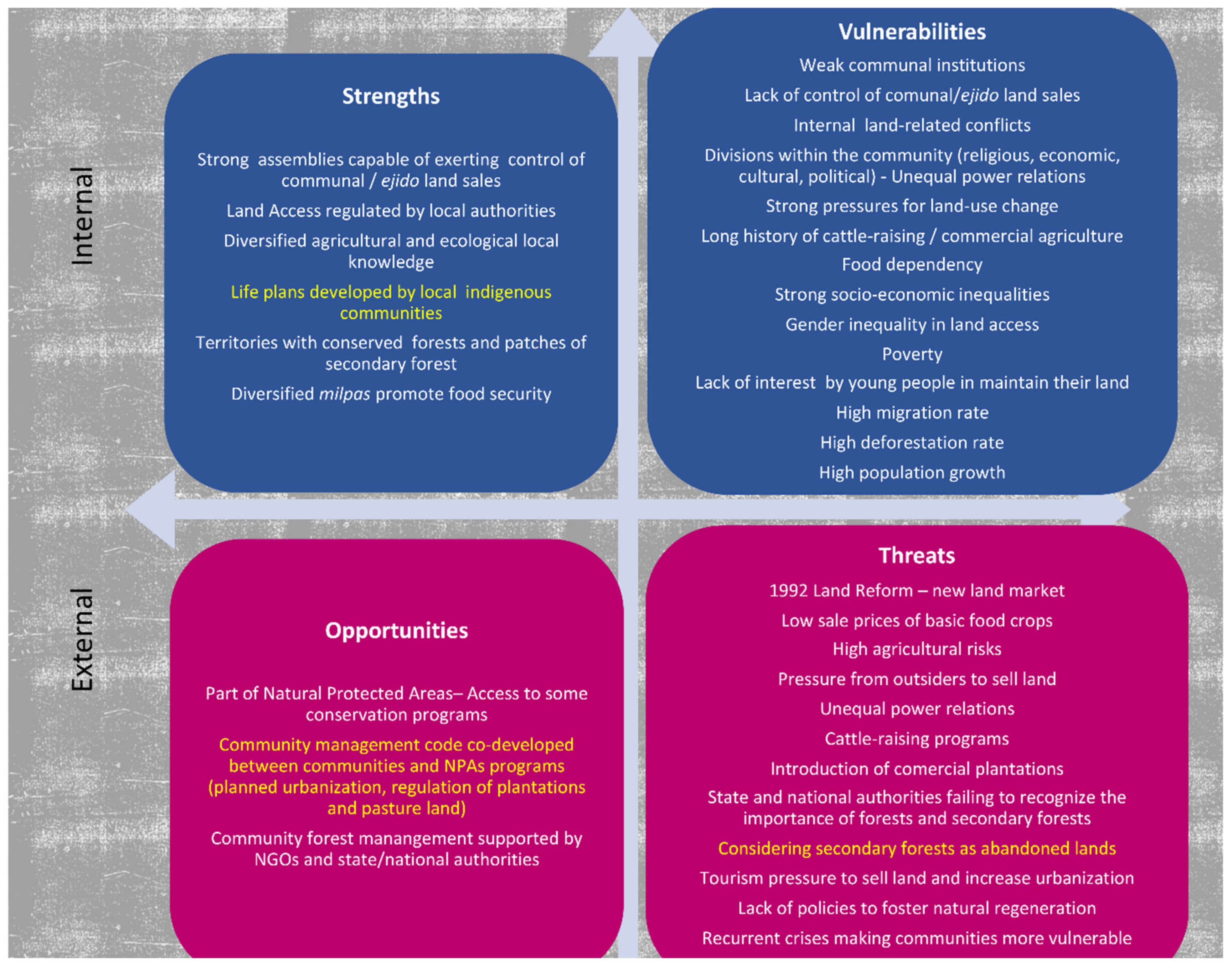
3.4. Strengths, Vulnerabilities, Opportunities, and Threats for Natural Regeneration

Understanding communities’ political, cultural, and socio-economic strengths and vulnerabilities, as well as external opportunities and threats, is crucial for restoration, particularly natural regeneration (Figure 2). In the three case studies, the accumulated socio-environmental vulnerabilities resulting from sale of ejido and communal land, weakening of communal institutions, and increased socio-economic inequity have resulted in abrupt land-use change from tropical and temperate forests to pastures, commercial monocultures, and urban areas (Figure 2).
The 1992 agrarian counter-reform favored privatization of land at varying rates, with a series of consequences. In Tatahuicapan and Marqués, this occurred gradually following implementation of PROCEDE. In Marqués, 5% of ejido land was privatized by 2007 but has since increased to 24% [81]. Meanwhile, in Tatahuicapan, privatization began in 2009, and by 2010, ejido members had sold 5% of their land. By 2019, it was estimated that 30–40% of the land had been sold. Despite gradual implementation of PROCEDE, livestock raising accelerated with the 2008 agricultural crisis, increasing deforestation. In turn, land sale for urbanization in Tepoztlán, which began in the late 1980s, increased significantly after the counter-reform, even though some communal assembly members decided not to participate in PROCEDE. At present, most communal land within the town limits of Tepoztlán has been sold (except the core of the two protected areas), and land sales have been expanding in nearby communities.
Some internal strengths of the communities could be developed to foster natural regeneration. If communal decision making bodies could be strengthened, they could better control their territories and regulate the land market, for example, prohibiting land sale to non-community residents, as some communities have done, and excluding outsiders from community assembly decisions. Developing “life plans” regarding the community’s environmental and economic future or “territorial management codes”—community maps including conservation, communal use, and agricultural areas as a result of agreements among community members, which have been applied in other communities of Mexico [110], could strengthen community regulations and facilitate conservation of primary and secondary forests (Figure 2).
Nevertheless, multiple threats exist, indicating the need for communities to preserve their forests and their milpas to achieve food autonomy. In all three case studies, the principal threat is pressure to sell land, which would lead communities to lose control of their territory, drastically reducing the possibility of landscape restoration through natural regeneration (Figure 2).

4. Discussion

Land sale has led to the transformation of social, cultural, economic, and political relationships in ejidos and communal landholdings. Purchase by mestizo stakeholders from outside the communities, whose interests contrast with those of the original indigenous peasants, leads to rapid community transformation. These newcomers consider land to be a business opportunity, rapidly converting it into commercial cropland and pastures in Marqués and Tatahuicapan and residential areas for weekend homes and hotels in Tepoztlán. Moreover, they have a political impact on community decision making and management. In Tatahuicapan, they even purchase ejido memberships to be able to vote in village assemblies. As more and more newcomers arrive, the original community members have difficulty making their voices heard. Shifting power relations modify the role and power of local communities, as well as recognition of their territorial rights. As newcomers impose their commercial interests, the possibilities of forest conservation and natural forest regeneration decrease.
The political and economic orientation of the new stakeholders thus shapes the territory. New institutional arrangements are gradually or rapidly being determined by political forces, including alliances among stakeholders, replacing traditional ones. Some ejido members make decisions according to traditional political mechanisms, while others are adapting to mechanisms and practices of government institutions. This has led to confrontation, which impedes implementation of forest conservation and management programs, along with drastic differences in perspectives that hinder true stakeholder engagement in reforestation and fostering natural regeneration. In such a context, negotiation cannot take place, and consensus regarding the dynamic long-term processes of restoration and regeneration is not possible. The outcome is that powerful newcomers—large-scale cattle raisers, commercial farmers, and city dwellers—increasingly control territory and local politics through land purchase and rental.
Placing stakeholders of all geographical levels at the center of natural regeneration would allow for the incorporation of their perspectives, interests, and needs, as well as the evaluation of the possibilities of long-term engagement of local, state, and federal authorities [111,112]. The new local stakeholders follow an individualist ideology that hinders collective agreements regarding natural regeneration of forests and fosters division within community assemblies and weakens territorial institutionality.
The social and political dimensions of restoration are critical to shaping restoration projects and their outcomes [4,113,114]. Unequal power relations between the State and local communities, as well as among communities and sectors within them, limit the development of diverse management projects and agendas. In our case studies, state and private economic and political agendas that promote cattle raising, commercial monocultures (such as oil palm), tourism, and urbanization limit the amount of land available for natural regeneration. Other more profitable outcomes—especially sale of land—appear to be more attractive to families lacking young people to work their fields, especially considering the low prices of traditional crops, such as maize and beans (Figure 2).
Particularly in Marqués de Comillas, the conservation value of oil-palm plantations could be enhanced by encouraging the coexistence of palm and native trees. However, rigid top-down government and industry regulations, which require high densities of palm monocultures, preclude this option. Even if peasants were interested in this more nature-friendly intercropping option, a new government policy would be necessary to allow for changes in plantation specifications and protection of remaining patches of natural vegetation.
The standardized approaches of cattle raising, the food industry, and government agencies in charge of reforestation/conservation programs do not promote the flexibility required to integrate practices such as conservation of patches of natural vegetation, the establishment of corridors among these patches, intercropping in plantations, and encouraging natural regeneration in landscape restoration.
Secure land tenure and land control by local communities are fundamental to the success, sustainability, and equitability of restoration [16,112]. As conflicts over land tenure and power relations have a decisive impact on restoration initiatives [112], negotiations to reach multi-stakeholder agreements for landscape restoration will be very costly in terms of time and resources and very tenuous unless clear pro-environment government policies back them. As public policy itself is the result of power struggles among various interests [115], this scenario seems unlikely, especially given that in Mexico, agricultural and tourism lobbies are much more powerful than environmental groups.
If the scale of landscape restoration were to grow, increasingly, more investment of time and money would be necessary for negotiations, especially if such initiatives attempt to increase participation by—and the equity of—marginalized communities. This is seldom recognized by global environmental initiatives, such as the Bonn Challenge, which evaluate restoration success in terms of area under tree cover and carbon sequestration [114].
There is an urgent need for clear commitment by the State to the development of more flexible and inclusive conservation/restoration policies and programs. Furthermore, they must also be willing to regulate the agri-food industry concerning its environmental impact. Currently, both possibilities are unlikely in Mexico and other Latin American countries. Land is important to the livelihoods of peasant communities, and its transformation into merchandise—fostered by economic policies and commercial interests—disrupts communal decision-making mechanisms and hinders agreements regarding conservation, reforestation, and forest regeneration.
Some communities of Chihuahua, Oaxaca, Yucatán, and Quintana Roo have successfully confronted significant threats and vulnerabilities presented by forestry projects by developing participatory management plans. As a case in point, some Mayan communities of southern Yucatan and central Quintana Roo maintain forestry-agricultural cycles, as well as their culture, in territories that they construct, transform, and defend. Forests and milpas provide a space for complex rituals that serve to establish attitudes and behaviors, which reproduce their lifeways [116]. The historic relationship between Mayans and rainforests includes maintenance of vegetation as a source of fertility for agriculture, as well as a variety of resources for domestic use and regional, national, and international markets [116]. Natural regeneration forms an essential part of this history [24,117]. The success of their forest management has not only been due to their identity as Mayans but also their organization, which has allowed for the maintenance of communal forest land. While these communities have faced significant challenges, vulnerabilities, and economic threats, they have managed to maintain a certain degree of control of their forests, providing examples for other communities.

5. Conclusions

The cases studies presented here involve communities within or near natural protected areas and thus with significant potential to promote natural regeneration. However, our results show that the vulnerabilities of these communities and threats to the conservation of their forest land are of such magnitude that conservation and forest recovery pose great challenges. These vulnerabilities are the result of an accumulation of social, economic, political, and environmental processes over the past three or four decades, which have resulted in drastic inequity, poverty, and land degradation. Modifications of property rights through the 1992 Agrarian Reform have led to increasing land sales and the transformation of communities’ sociopolitical institutions, thereby limiting their land-use decision-making ability—in this case, concerning land availability for natural regeneration. Land sales—and the new owners—combined with incompatibility between traditional and new land uses, result in an unfavorable scenario for natural regeneration, especially considering that governmental policies are usually mutually contradictory and often provide more support for economic activities than for environmental conservation.
The three study cases studies presented here are representative of a large proportion of rural communities in Mexico that are threatened by similar processes: land sales to people from outside the community—who often possess much greater economic power; partial or total transformation of forests to commercial plantations or pastures for extensive cattle raising; and conversion to urban areas. Some Mexican communities are subject to even more violent dispossession from their land through mining, installation of wind farms, development of industrial corridors (i.e., the Trans-Isthmus Corridor), the large-scale tourist industry, and control of their territories by drug traffickers. Furthermore, many communities, particularly in the state of Oaxaca [118], have historically undergone internal land conflicts involving disputes over borders between indigenous communities and between indigenous and mestizo communities. Finally, many communities have not promoted natural regeneration, as regenerated land could be interpreted as unnecessary and even taken over by other communities [118].
In addition to tension over land ownership and land-use competition, public policy does not favor natural regeneration in acahuales. Therefore, few community residents consider forest regrowth to be a viable land-use option. Government programs should develop land management programs that provide economic support for forest regeneration, as PES is currently not competitive with commercial land uses. Furthermore, there is a need for participatory land-use planning, legislation, and monitoring.
In rural Latin America, socio-environmental, economic, social, political, and cultural vulnerabilities, along with a lack of holistic social welfare policies, push peasants to abandon agricultural-forestry cycles, choose more profitable—but less stable—economic activities and land uses, and eventually sell or rent their land. This, in turn, leads to migration—principally of younger men—leaving the elderly and women with young children in the communities. Corn production, which promotes food security and is strongly tied to ancestral culture, is sustained by remittances from these migrants, but their highly vulnerable situation leads to rental and sale of land, and in turn, loss of control over their territories and community decision making.
Reforestation and natural regeneration are immersed in these complex contexts of vulnerabilities, uncertainties, social inequity, land disputes, socio-environmental conflicts, and ruptures of territorial identity. Nevertheless, in Mexico, some well-organized communities—such as the Mayans of Yucatán and Quintana Roo and Zapotec communities of Oaxaca—have long managed their forests and incorporated reforestation and natural regeneration into land management.
The many examples of diverse community forest management types in Mexico indicate the possibility of hybrid forest land use involving controlled forest management, natural regeneration, traditional milpas, and commercial agriculture. Living fences, biological corridors and smaller connected remnant forest patches, Mayan tolches (rows of trees along roads), and small forest reserves within villages (fundos legales) are just some of the ways of promoting natural regeneration according to community agreements. As long as the communities maintain control of their territories and are provided with goods and services from their regenerated forests, natural regeneration may be the first step in forest recovery. Some Mexican organizations that follow the principle of self-determination—for example, Oaxaca, Puebla, and Michoacán—have established community forestry with a long-term perspective [110]. This requires local decision-making institutions that allow for dialogue, respect agreements, and provide transparency of community forest management, strengthening networks of trust. Furthermore, multi-actor participation and commitment can strengthen networks on different geographical levels to allow communities to build capacities to respond to the various threats they face.
In such organized communities, younger generations may be able to contemplate staying in their communities and transforming their agri-food systems and forestry territories that allow them to meet their needs. However, in most communities, such as those of the case studies, youth face economic threats that pressure them to sell their land. In all three cases, young people are willing to sell their parents’ or grandparents’ land to invest in urban livelihoods—for example, as taxi drivers or store owners or to try to cross the US border. Other youths are willing to cultivate their land but lack the security of inheritance. Nevertheless, due to various vulnerabilities, especially health problems of family members, land inheritance is always uncertain. If they can cope with these vulnerabilities, young people could develop agroforestry systems involving innovative rotation systems, thereby combining their agri-food systems with forest regeneration and conservation.

Author Contributions

All authors participated actively in conceiving and drafting this manuscript. E.L.-C. coordinated manuscript preparation and final revision. All authors have read and agreed to the published version of the manuscript.

Funding

The research made in Veracruz was funded by the PAPIIT program (“Programa de Apoyo a Proyectos de Investigación e Innovación Tecnológica”) of the Universidad Nacional Autónoma de México for the project titled ‘Threats and vulnerabilities in Mexican agriculture: loss of agrobiodiversity and control of seeds, youth migration, and climate change’ (PAPIIT IN304519), coordinated by Elena Lazos Chavero. The research made in Chiapas was funded by Fondecyt (Project 11191021).

Institutional Review Board Statement

We followed the Ethic Code of the Association of Social Anthropologists of the UK and the Commonwealth. Ethical Guidelines for Good Research Practice, and the Ethic Code of the UNAM.

Informed Consent Statement

Informed consent was obtained from all subjects involved in the study.

Data Availability Statement

Data supporting reported results can be found in the author’s archives.

Acknowledgments

E.L. gratefully acknowledges the Nahua families of Tatahuicapan, Veracruz that shared their knowledge, perspectives, and concerns regarding their forests and their livelihoods. Financial support was provided by the PAPIIT program (Programa de Apoyo a Proyectos de Investigación e Innovación Tecnológica) of the Universidad Nacional Autónoma de México for the project titled ‘Threats and vulnerabilities in Mexican agriculture: loss of agrobiodiversity and control of seeds, youth migration, and climate change’ (PAPIIT IN304519), coordinated by Elena Lazos Chavero. Thanks to the students Tania Flores, Marcela Jiménez, Luz Llamas, Cloe Mirenda, Jazmín Solís, Esteban Ramírez, and my daughter, Sara Gugerli, for their enthusiastic participation in fieldwork and for systematizing the information. P.M. thanks Fondecyt for support (Project 11191021). C.B. acknowledges Bárbara Puente, Daniel Romo, Karla Bilbatúa, and Bruno Barrales for their contributions to this study, as well as members of the community of Amatlán for sharing their experiences.

Conflicts of Interest

The authors declare they have no conflict of interest.

Notes

1
The concept of vulnerability originated in diverse disciplines and theoretical frameworks regarding disasters such as famines and climate change. Human ecology highlights adaptation, consensus, and strategies to overcome vulnerabilities, while Political Economy and Political Ecology emphasize differentiated vulnerabilities of social classes with unequal access to resources and power. Considering these perspectives, as well as the definition by the International Strategy for Disaster Reduction [119,120], we consider vulnerability to be the degree to which a political and socio-economic system, together with lack of physical and ecological assets, creates susceptibility to disasters. Vulnerability is determined by a combination of the following factors: socio-economic, ecological, political, and cultural conditions of human settlements; public policies and government administration; socio-economic inequities and lack of organized capacities in disaster and risk management. As stated by the ISDR (119, Item 9:6), “The specific dimensions of social, economic and political vulnerabilities are also related to inequalities, gender relations, economic patterns, and ethnic and racial divisions”. Reaffirming the idea that vulnerability is linked to “lack of freedom—the freedom to influence the political economy that shapes entitlements”, such as rights to assets and social protection [121,122].
2
The ejido land tenure system resulted from the Mexican Revolution and was recognized by the 1917 Constitution (Section 3.1 discusses its characteristics). The communal land tenure system was recognized by the Spanish Crown during the colonial era as land belonging to indigenous communities. Some communities with communal land tenure have divided their land into family or individual plots, while others have maintained all or part of their land as a common.
3
The most common vegetation types are high and medium rainforest (1873 species reported); mangroves (98 species); cloud forest (786 species); pine and oak forest (732 species); savanna (146 species); coastal dunes (315 species); fallows (249 species), and secondary forests (283 species; [123]).
4
As the Programa de Desmontes and Programa de Colonización del Trópico.
5
In such a contract, a landowner cares for the livestock of another person, providing inputs for land where the animals are raised, while the owner of the animals provides any medicines necessary. Newborns are divided equally between both parties.

References

  1. Chazdon, R.L.; Guariguata, M.R. Natural regeneration as a tool for large-scale forest restoration in the tropics: Prospects and challenges. Biotropica 2016, 48, 716–730. [Google Scholar] [CrossRef]
  2. Arroyo-Rodríguez, V.; Melo, F.P.; Martínez-Ramos, M.; Bongers, F.; Chazdon, R.L.; Meave, J.A.; Norden, N.; Santos, B.A.; Leal, I.R.; Tabarelli, M. Multiple successional pathways in human-modified tropical landscapes: New insights from forest succession, forest fragmentation and landscape ecology research. Biol. Rev. 2017, 92, 326–340. [Google Scholar] [CrossRef] [PubMed]
  3. Mansourian, S. Governance and forest landscape restoration: A framework to support decision-making. J. Nat. Conserv. 2017, 37, 21–30. [Google Scholar] [CrossRef]
  4. Chazdon, R.L.; Wilson, S.J.; Brondizio, E.; Guariguata, M.R.; Herbohn, J. Key challenges for governing forest and landscape restoration across different contexts. Land Use Policy 2021, 104, 104854. [Google Scholar] [CrossRef]
  5. Crouzeilles, R.; Barros, F.S.; Chazdon, R.L.; Ceccon, E.; Adams, C.; Lazos-Chavero, E.; Monteiro, L.; Junqueira, A.B.; Strassburg, B.B.; Guariguata, M.R.; et al. Associations between socio-environmental factors and landscape-scale biodiversity recovery in naturally regenerating tropical and subtropical forests. Conserv. Lett. 2021, 14, 1–9. [Google Scholar] [CrossRef]
  6. Lamb, D.; Erskine, P.D.; Parrotta, J.A. Restoration of degraded tropical forest landscapes. Science 2005, 310, 1382–1385. [Google Scholar] [CrossRef] [Green Version]
  7. Nagendra, H. Drivers of reforestation in human-dominated forests. Proc. Natl. Acad. Sci. USA 2007, 104, 15218–15223. [Google Scholar] [CrossRef] [Green Version]
  8. Composto, C.; Navarro, M. Estados, transnacionales extractivas y comunidades movilizadas: Dominación y resistencias en torno de la minería a gran escala en América Latina. Theomai 2012, 25, 58–78. [Google Scholar]
  9. Sunderlin, W.D.; Larson, A.M.; Duchelle, A.E.; Resosudarmo, I.A.; Huynh, T.B.; Awono, A.; Dokken, T. How are REDD+ Proponents Addressing Tenure Problems? Evidence from Brazil, Cameroon, Tanzania, Indonesia, and Vietnam. World Dev. 2014, 55, 37–52. [Google Scholar] [CrossRef]
  10. Navarro, M.L. Luchas Por lo Común. Antagonismo Social Contra el Despojo Capitalista de Los Bienes Naturales en México; Instituto de Ciencias Sociales y Humanidades “Alfonso Vélez Pliego”: Mexico City, Mexico, 2015. [Google Scholar]
  11. Torres-Mazuera, G. ¿Tierras ejidales como mercancía o como territorio indígena? Intermediación legal y nuevas interpretaciones disonantes de la legislación agraria en el México contemporáneo, Caravelle. Cah. Monde Hisp. Luso-Brésilien 2019, 112, 95–108. [Google Scholar]
  12. Brondizio, E.S.; Ostrom, E.; Young, O.R. Connectivity and the Governance Of Multilevel Social-Ecological Systems: The Role of Social Capital. Annu. Rev. Environ. Resour. 2009, 34, 253–278. [Google Scholar] [CrossRef]
  13. Larson, A.M.; Brockhaus, M.; Sunderlin, W.D.; Duchelle, A.; Babon, A.; Dokken, T.; Pham, T.T.; Resosudarmo, I.A.; Selaya, G.; Awono, A.; et al. Land tenure and REDD+: The good, the bad and the ugly. Glob. Environ. Change 2013, 23, 678–689. [Google Scholar] [CrossRef]
  14. DeFries, R.; Rudel, T.; Uriarte, M.; Hansen, M. Deforestation driven by urban population growth and agricultural trade in the twenty-first century. Nat. Geosci. 2010, 3, 178–181. [Google Scholar] [CrossRef]
  15. Ellis, E.A.; Hernández-Gómez, I.U.; Romero-Montero, J.A. Los procesos y causas del cambio en la cobertura forestal de la Península Yucatán, México. Ecosistemas 2017, 26, 101–111. [Google Scholar] [CrossRef]
  16. McLain, R.; Lawry, S.; Guariguata, M.R.; Reed, J. Toward a Tenure-Responsive Approach to Forest Landscape Restoration: A Proposed Tenure Diagnostic for Assessing Restoration Opportunities Land Use Policy. 2021. Available online: https://www.sciencedirect.com/science/article/pii/S0264837718303855?via%3Dihub (accessed on 30 September 2021). [CrossRef]
  17. Wright, S.; Muller-Landau, H.; Schipper, L. The future of tropical species on a warmer planet. Conserv. Biol. 2009, 23, 1418–1426. [Google Scholar] [CrossRef]
  18. Bowen, M.E.; McAlpine, C.A.; House, P.N.; Smith, G.C. Regrowth forests on abandoned agricultural land: A review of their habitat values for recovering forest fauna. Biol. Conserv. 2007, 140, 273–296. [Google Scholar] [CrossRef]
  19. Filotas, E.; Parrott, L.; Burton, P.J.; Chazdon, R.L.; Coates, K.D.; Coll, L.; Haeussler, S.; Martin, K.; Nocentini, S.; Puettmann, K.J.; et al. Viewing forests through the lens of complex systems science. Ecosphere 2014, 5, 1–23. [Google Scholar] [CrossRef]
  20. Ghazoul, J.; Chazdon, R.L. Degradation and recovery in changing forest landscapes: A multiscale conceptual framework. Annu. Rev. Environ. Resour. 2017, 42, 161–188. [Google Scholar] [CrossRef] [Green Version]
  21. Rozendaal, D.M.; Bongers, F.; Aide, T.M.; Alvarez-Dávila, E.; Ascarrunz, N.; Balvanera, P.; Becknell, J.M.; Bentos, T.V.; Brancalion, P.H.; Cabral, G.A. Biodiversity recovery of neotropical secondary forests. Sci. Adv. 2019, 5, 1–10. [Google Scholar] [CrossRef] [Green Version]
  22. Hernández-Xolocotzi, E.; Levy-Tacher, S.I.; Bello-Baltazar, Y.E. La roza-tumba-quema en Yucatán. In La Milpa en Yucatán: Un Sistema de Producción Agrícola Tradicional; Colegio de México: Mexico City, Mexico, 1995. [Google Scholar]
  23. Metzger, J.P. Landscape dynamics and equilibrium in areas of slash-and-burn agriculture with short and long fallow period (Bragantina region, NE Brazilian Amazon). Landsc. Ecol. 2002, 17, 419–431. [Google Scholar] [CrossRef]
  24. Levy-Tacher, S.I.; Ramírez-Marcial, N.; Navarrete-Gutiérrez, D.A.; Rodríguez-Sánchez, P.V. Are Mayan community forest reserves effective in fulfilling people’s needs and preserving tree species? J. Environ. Manag. 2019, 245, 16–27. [Google Scholar] [CrossRef]
  25. Nigh, R.; Ford, A. El Jardín Forestal Maya: Ocho Milenios de Cultivo Sostenible de los Bosques Tropicales; Fray Bartolomé de las Casas: Mexico City, Mexico, 2019; p. 283. [Google Scholar]
  26. Oliver-Smith, A. Anthropological research on hazards and disasters. Annu. Rev. Anthropol. 1996, 25, 303–328. [Google Scholar] [CrossRef]
  27. McLaughlin, P.; Dietz, T. Structure, agency and environment: Toward an integrated perspective on vulnerability. Glob. Environ. Change 2008, 18, 99–111. [Google Scholar] [CrossRef]
  28. Wilches-Chaux, G. Desastres, Ecologismo y Formación Profesional; SENA: Bogota, Colombia, 1989. [Google Scholar]
  29. Blaikie, P.; Cannon, T.; Davis, I.; Wisner, B. At Risk: Natural Hazards, People’s Vulnerability and Disasters; Routledge: London, UK, 1994. [Google Scholar]
  30. Hecht, S.B.; Morrison, K.D.; Padoch, C. The Social Lives of Forests. Past, Present, and Future of Woodland Resurgence; The University of Chicago Press: Chicago, IL, USA, 2014. [Google Scholar]
  31. Li, S.; Li, X. Global understanding of farmland abandonment: A review and prospects. J. Geogr. Sci. 2017, 27, 1123–1150. [Google Scholar] [CrossRef]
  32. DiGiano, M.; Ellis, E.; Keys, E. Changing landscapes for forest commons: Linking landtenure with forest cover change following Mexico’s 1992 Agrarian counter-reforms. Hum. Ecol. 2013, 41, 707–723. [Google Scholar] [CrossRef]
  33. Secretaría de Medio Ambiente y Recursos Naturales (SEMARNAT). Compendio de Superficie Reforestada. Available online: https://apps1.semarnat.gob.mx:8443/dgeia/compendio_2016/archivos/01_rforestales/D3_RFORESTA09_06.pdf (accessed on 8 October 2021).
  34. Comisión Nacional Forestal (CONAFOR). Estimación de la Tasa de Deforestación en México Para el Periodo 2001–2018 Mediante el Método de Muestreo. Documento Técnico; Comisión Nacional Forestal (CONAFOR): Zapopan, Mexico, 2020.
  35. Comisión Nacional Forestal (CONAFOR). Inventario Nacional Forestal y de Suelos. Informe de Resultados 2009–2014; Comisión Nacional Forestal (CONAFOR): Mexico City, Mexico, 2018.
  36. UN Food and Agriculture Organization (FAO). Evaluación de los Recursos Forestales Mundiales 2020; UN Food and Agriculture Organization (FAO): Rome, Italy, 2021. [Google Scholar]
  37. Marcus, G.E. Ethnography in/of the world system: The emergence of multi-sited Ethnography. Annu. Rev. Anthropol. 1995, 24, 95–117. [Google Scholar] [CrossRef]
  38. Warman, A. La reforma al Artículo 27 Constitucional. Estud. Agrar. Rev. Procur. Agrar. 1996, 2, 9–19. [Google Scholar]
  39. Mackinlay, H. Las reformas de 1992 a la legislación agraria. El fin de la Reforma Agraria mexicana y la privatización del ejido. Polis 1993, 93, 99–127. [Google Scholar]
  40. Janvry, A.; Gordillo, G.; Sadoulet, E. Mexico’s Second Agrarian Reform: Household and Community Response, 1990–1994; University of California: San Diego, CA, USA, 1997. [Google Scholar]
  41. Deere, C.D.; Leon, M. Gender, land and water: From reform to counter-reform in Latin America. Agric. Hum. Values 1998, 15, 375–386. [Google Scholar] [CrossRef]
  42. Zepeda, G. Transformación Agraria: Los Derechos de Propiedad en el Campo Mexicano bajo un Nuevo Marco Institucional, Mexico; CIDAC: Lisbon, Portugal, 2000; p. 8. [Google Scholar]
  43. Barnes, G. The evolution and resilience of community-based land tenure in rural Mexico. Land Use Policy 2009, 26, 393–400. [Google Scholar] [CrossRef]
  44. Haenn, N. The changing and enduring ejido: A state and regional examination of Mexico’s landland tenure counter-reforms. Land Use Policy 2006, 23, 136–146. [Google Scholar] [CrossRef]
  45. Bray, D.B.; Antinori, C.; Torres-Rojo, J.M. The mexican model of community forest management: The role of agrarian policy, forest policy and entrepreneurial organization. For. Policy Econ. 2006, 8, 470–484. [Google Scholar] [CrossRef]
  46. Lazos, E. La Ganaderización de dos Comunidades Veracruzanas: Condiciones de la Difusión de un Modelo Agrario. In El Ropaje de la Tierra. Naturaleza y Cultura en Cinco Zonas Rurales; Paré, L., Sánchez, M.J., Eds.; IIS-UNAM/Plaza y Valdes: Mexico City, Mexico, 1996; pp. 177–242. [Google Scholar]
  47. Durand, L.; Lazos, E. Colonization and tropical deforestation in Sierra Santa Marta, Southern Mexico. Environ. Conserv. 2004, 31, 11–21. [Google Scholar] [CrossRef]
  48. Durand, L.; Lazos, E. The local perception of tropical deforestation and its relation to conservation policies in Los Tuxtlas Biosphere Reserve, Mexico. Hum. Ecol. An. Interdiscip. J. 2008, 36, 323–394. [Google Scholar] [CrossRef]
  49. Secretaría de Finanzas y Planeación de Veracruz (SEFIPLAN Veracruz), Cuenta Pública 2018. SEFIPLAN Veracruz, Gobierno del estado de Veracruz: Veracruz, Mexico. 2018. Available online: http://www.veracruz.gob.mx/finanzas/transparencia/transparencia-proactiva/contabilidad-gubernamental/cuenta-publica/cuenta-publica-2018/ (accessed on 8 October 2021).
  50. Ramírez, R.F. Conservación de la Biodiversidad en la Región de Los Tuxtlas, Veracruz; Charleton University: Mexico City, Mexico, 1991. [Google Scholar]
  51. Soto, M. El Clima. In Los Tuxtlas. El Paisaje de la Sierra; Guevara, S., Laborde, J., Sánchez-Ríos, G., Eds.; Instituto de Ecología A.C. and European Union: Veracruz, Mexico, 2006; pp. 195–200. [Google Scholar]
  52. Buckles, D.J. Cattle, Corn and Conflict in the Mexican Tropics; Carleton University: Ottawa, ON, Canada, 1989. [Google Scholar]
  53. Velázquez, E. Política, ganadería y recursos naturales en el trópico húmedo veracruzano: El caso del municipio de Mecayapan. Relac. Estud. Hist. Soc. 1992, XII, 23–63. [Google Scholar]
  54. Lazos, E.; Godínez, L. Dinámica familiar y el inicio de la ganadería en tierras campesinas del sur de Veracruz. In El Ropaje de la Tierra. Naturaleza y Cultura en Cinco Zonas Rurales; Paré, L., Sánchez, M.J., Eds.; IIS-UNAM Plaza y Valdés: Mexico City, Mexico, 1996; pp. 243–354. [Google Scholar]
  55. Barrera, N.; López, C.; Palma, R. Vacas, pastos y bosques en Veracruz: 1950–1990. In Desarrollo y Medio Ambiente en Veracruz. Impactos Económicos, Ecológicos y Culturales de la Ganadería en Veracruz; Barrera, N., Rodríguez, H., Eds.; CIESAS-Golfo, Instituto de Ecología y Friedrich Ebert Stiftung: Mexico City, Mexico, 1993; pp. 35–71. [Google Scholar]
  56. Challenger, A.; Soberón, J. Los Ecosistemas Terrestres; CONABIO: Mexico City, Mexico, 2008; Volume 1.
  57. Lazos, E. Vulnerabilidades en el campo mexicano: Ruptura del territorio agroalimentario en la Sierra de Santa Marta, sur de Veracruz, México. Aliment. Salud Sustentabilidad 2020, 179–208. Available online: http://www.humanindex.unam.mx/humanindex/consultas/detalle_capitulos.php?id=31344&rfc=TEFDRTYwMDEwMg==&idi=1 (accessed on 25 November 2021).
  58. De Vos, J. Una tierra para sembrar sueños. In Historia Reciente de la Selva Lacandona 1950–2000; Fondo de Cultura Económica: Mexico City, Mexico, 2002. [Google Scholar]
  59. Castro, E.; de la Maza, J.; Meli, P.; Carabias, J. Colonización e instituciones gubernamentales en el municipio de Marqués de Comillas. In Conservación y Desarrollo Sustentable en la Selva Lacandona. 25 Años de Actividades y Experiencias; Carabias, J., de la Maza, J., Cadena, R., Eds.; Natura y Ecosistemas Mexicanos A.C.: Mexico City, Mexico, 2015; pp. 211–218. [Google Scholar]
  60. González-Ponciano, J. Marqués de Comillas: Cultura y sociedad en la selva fronteriza México-Guatemala. In Chiapas los Rumbos de Otra Historia; Viqueira, J.P., Ruz, H.M., Eds.; UNAM-CIESAS: Mexico City, Mexico, 1996; pp. 425–444. [Google Scholar]
  61. De Jong, B.H.; Ochoa-Gaona, S.; Castillo-Santiago, M.A.; Ramírez-Marcial, N.; Cairns, M.A. Carbon flux and patterns of land-use/land-cover change in the Selva Lacandona, Mexico. Ambio 2000, 29, 504–511. [Google Scholar] [CrossRef]
  62. Harvey, N. La Remunicipalización en Marqués de Comillas y Benemérito de Las Américas, Chiapas: Entre la Vía Institucional y la Vida Cotidiana; CIESAS: Mexico City, Mexico, 2001. [Google Scholar]
  63. Harvey, N. Benemérito de las Américas y Marqués de Comillas; Gobierno del Estado de Chiapas: Tuxtla Gutiérrez, Mexico, 2006; p. 235. [Google Scholar]
  64. Registro Agrario Nacional (RAN). Estructura de la Propiedad Social. In Mensual; Registro Nacional Agrario (RAN): Morelia, Mexico, 2021. [Google Scholar]
  65. Consejo Nacional de Evaluación de la Política de Desarrollo Social (CONEVAL). Informe Anual Sobre La Situación de Pobreza y Rezago Social, Marqués de Comillas, Chiapas; Consejo Nacional de Evaluación de la Política de Desarrollo Social (CONEVAL) y Secretaría de Desarrollo Social (SEDESOL): Mexico City, Mexico, 2014. [Google Scholar]
  66. Lazos, E. Ciclos y rupturas: Dinámica ecológica de la ganadería en el sur de Veracruz. In Historia Ambiental de la Ganadería en México; Hernández, L., Ed.; Institut Recherche Développement: Durango, Mexico, 2001; pp. 133–153. [Google Scholar]
  67. Paré, L.; Lazos, E. Escuela Rural y Organización Comunitaria: Instituciones Locales para el Desarrollo y el Manejo Ambiental; IIS-UNAM/Plaza y Valdés: Mexico City, Mexico, 2003; p. 405. [Google Scholar]
  68. Meli, P.; Hernández, G.; Castro, E.; Carabias, J. Vinculando paisaje y parcela: Un enfoque multi-escala para la restauración ecológica en áreas rurales. Investig. Ambient. 2015, 7, 43–53. [Google Scholar]
  69. Meli, P.; Aguilar-Fernández, R.; Carabias, J. Restauración ecológica en Marqués de Comillas. In Conservación y Desarrollo Sustentable en la Selva Lacandona. 25 Años de Actividades y Experiencias; Carabias, J., de la Maza, J., Cadena, R., Eds.; Natura y Ecosistemas Mexicanos A.C.: Mexico City, Mexico, 2015; pp. 429–458. [Google Scholar]
  70. Meli, P.; Martínez-Ramos, M.; Rey-Benayas, J.M.; Carabias, J. Combining ecological, social, and technical criteria to select species for forest restoration. Appl. Veg. Sci. 2014, 17, 744–753. [Google Scholar] [CrossRef] [Green Version]
  71. Meli, P.; Rey-Benayas, J.M.; Martínez-Ramos, M.; Carabias, J. Effects of grass clearing and soil tilling on establishment of planted tree seedlings in tropical riparian pastures. New For. 2015, 46, 507–525. [Google Scholar] [CrossRef]
  72. Aguilar, R.; Meli, P.; Carabias, J. Modelos de restauración ecológica para la recuperación de servicios ecosistémicos. In Conservación y Desarrollo Sustentable en la Selva Lacandona; Carabias, J., Cadena, R., de la Maza, J., Castro, E., Eds.; Natura y Ecosistemas Mexicanos A.C.: Mexico City, Mexico, 2021; Volume 2. [Google Scholar]
  73. Aguilar, R. Análisis de los Componentes Socioambientales Para la Restauración de Claros Antropogénicos en la Selva Tropical Húmeda, Marqués de Comillas, Chiapas. Ph.D. Thesis, Facultad de Ciencias, UNAM, Mexico City, Mexico, 2013. [Google Scholar]
  74. Bilbatúa, K. Diagnóstico de la Vegetación de Amatlán, Morelos, Mexico, con Fines de Conservación y Restauración; Maestría en Ciencias Biológicas, UNAM: Mexico City, Mexico, 2019. [Google Scholar]
  75. Fernández-Suárez, B. Caracterización de la Vegetación del Sotobosque en Amatlán de Quetzalcóatl, Tepoztlán, Morelos; Facultad de Ciencias, UNAM: Mexico City, Mexico, 2021. [Google Scholar]
  76. Cayetano, R. Avifauna de Amatlán de Quetzalcóatl, Tepoztlán, México; Facultad de Estudios Superiores Iztacala, UNAM: Mexico City, Mexico, 2014. [Google Scholar]
  77. Núñez-Cruz, A.; Meave, J.A.; Bonfil, C. Reproductive phenology and seed germination in eight tree species from a seasonally dry tropical forest of Morelos, Mexico, implications for community-oriented restoration and conservation. Trop. Conserv. Sci. 2018, 11, 1–14. [Google Scholar] [CrossRef]
  78. Calzada, L.; Meave, J.A.; Bonfil, C.; Figueroa, F. Lands at risk: Land use/land cover change in two contrasting tropical dry regions of Mexico. Appl. Geogr. 2018, 99, 22–30. [Google Scholar] [CrossRef]
  79. Puente-Uribe, B.; Calzada, L.; Bonfil, C.; Figueroa, F. Prácticas agrícolas y conservación de la agrobiodiversidad en Amatlán de Quetzalcóatl. In La Biodiversidad en Morelos. Estudio de Estado 2; CONABIO: Mexico City, Mexico, 2020; Volume III, pp. 428–433. [Google Scholar]
  80. Puente-Uribe, B. Transformación Agrícola y su Contexto Socioambiental en Amatlán de Quetzalcóatl, Morelos; Maestría en Ciencias de la Sostenibilidad, UNAM: Mexico City, Mexico, 2019. [Google Scholar]
  81. Registro Agrario Nacional (RAN). Ejido de Tatahuicapan de Juárez. Available online: https://phina.ran.gob.mx/index.php (accessed on 8 October 2021).
  82. Lazos, E.; Jiménez, M. Vulnerabilidades rurales a partir del envejecimiento entre nahuas del sur de Veracruz. TRACE 2021, in press. [Google Scholar]
  83. Corbera, E.; Kosoy, N.; Martínez, M. Equity implications of marketing ecosystem services in protected areas and rural communities: Case studies from Meso-America. Glob. Environ. Change 2007, 17, 365–380. [Google Scholar] [CrossRef]
  84. Nuitjen, M. Family Property and the Limits of Intervention: The Article 27 Reforms and the PROCEDE Programme in Mexico. Develop. Change 2003, 34, 475–497. [Google Scholar]
  85. Castellanos-Navarrete, A.; Jansen, K. Oil palm expansion without enclosure: Smallholders and environmental narratives. J. Peasant. Stud. 2015, 42, 791–816. [Google Scholar] [CrossRef]
  86. Del Ángel-Mobarak, G.A. La Comisión Nacional Forestal en la Historia y el Futuro de la Política Forestal de México; Centro de Investigación y Docencia Económicas CONAFOR: Mexico City, Mexico, 2012. [Google Scholar]
  87. Iglesias, L.; Martínez, E.R.; Graf, S.; Muñoz-Piña, C.; Gutiérrez, J.; Flores, F.; Bauche, P.; Iglesias, L.; Martínez, E.R.; Graf, C.; et al. Patrimonio Natural de México. Cien Casos de Éxito; Carabias, J.S., de la Maza, J., Galindo, C., Eds.; CONABIO: Mexico City, Mexico, 2010. [Google Scholar]
  88. Romo-Cruz, D. Factores Socioambientales Asociados a la Urbanización en el Municipio de Tepoztlán, Morelos (1985–2015); Maestría en Ciencias de la Sostenibilidad, UNAM: Mexico City, Mexico, 2019. [Google Scholar]
  89. Rodríguez, G. Subsidios Destinados al Sector Ganadero, el Caso del PROGAN 2008. 2013. Available online: www.subsidiosalcampo.org (accessed on 10 October 2021).
  90. Instituto Nacional de Estadística. Geografía e Informática (INEGI), Veracruz de Ignacio de la Llave (30). Available online: https://www.inegi.org.mx/app/areasgeograficas/?ag=30 (accessed on 8 October 2021).
  91. Guevara, S.; Laborde, J.; Sánchez-Ríos, G. Los Tuxtlas. El Paisaje de la Sierra; Instituto de Ecología: Veracruz, Mexico, 2004. [Google Scholar]
  92. Von Thaden, J.J.; Laborde, J.; Guevara, S.; Mokondoko-Delgadillo, P. Dinámica de los cambios en el uso del suelo y cobertura vegetal en la Reserva de la Biosfera Los Tuxtlas (2006–2016). Rev. Mex. Biodivers. 2020, 91, 1–14. [Google Scholar] [CrossRef]
  93. Proyecto Sierra de Santa Marta A.C. (PSSM). Actualización de la Tasa de Cambio del Uso de Suelo en la Reserva de la Biosfera Los Tuxtlas, Informe Final; Comisión Nacional de Áreas Naturales Protegidas: Baja California, Mexico, 2011.
  94. Mendoza, E. Análisis de la Deforestación de la Selva Lacandona: Patrones, Magnitud y Consecuencias; Facultad de Ciencias, UNAM: Mexico City, Mexico, 1997. [Google Scholar]
  95. González, M.A.; Carabias, J.; Auzias, C.; Castro, E.; Acevedo, M.A. Ordenamiento Comunitario del Territorio de la Microrregión Marqués de Comillas: Una Iniciativa Interejidal para el Mejoramiento de los Medios de Vida Rurales en la Selva Lacandona; Grupo Autónomo para la Investigación Ambiental: Oaxaca, Mexico, 2012. [Google Scholar]
  96. Obregón, R. Programa Preliminar de Desarrollo Agroecológico del Municipio Marqués de Comillas; CBM–Conabio: Mexico City, Mexico, 2007.
  97. Hernandez-Rojas, D.A.; Lopez-Barrera, F.; Bonilla-Moheno, M. Análisis preliminar de la dinámica de uso del suelo asociada al cultivo palma de aceite (Elaeis guineensis) en México. Agrociencia 2018, 52, 875–889. [Google Scholar]
  98. SIAP-SAGARPA. Superficies de Siembra de Cultivos Perennes y de Temporal (2006–2016). Available online: http://infosiap.siap.gob.mx/gobmx/datosAbiertos_a.php (accessed on 30 November 2021).
  99. Castellanos-Navarrete, A. Oil palm on peasant lands: The politics of territorial transformations in Chiapas, Mexico. Rev. Pueblos Front. Digit. 2018, 13, 1–34. [Google Scholar]
  100. De la Maza, J.; Mastretta, A.; Ruiz, L.; Carabias, J. Ecoturismo para la conservación. In Conservación y Desarrollo Sustentable en la Selva Lacandona. 25 Años de Actividades y Experiencias; Carabias, J., de la Maza, J., Cadena, R., Eds.; Natura y Ecosistemas Mexicanos A.C.: Mexico City, Mexico, 2015; pp. 333–352. [Google Scholar]
  101. Ortiz, R.; Straffon, S.; de la Maza, J.; Carabias, J. Historia y análisis de la UMA extensiva de mariposas La Casa del Morpho. In Conservación y Desarrollo Sustentable en la Selva Lacandona. 25 Años de Actividades y Experiencias; Carabias, J., de la Maza, J., Cadena, R., Eds.; Natura y Ecosistemas Mexicanos A.C.: Mexico City, Mexico, 2015; pp. 375–394. [Google Scholar]
  102. Valadez, V.; Carabias, J.; Noriega, D.; Ramírez, J.J.; Barceinas, A.; de la Maza, J. Empresas ecoturísticas sociales que operan en Marqués de Comillas. In Conservación y Desarrollo Sustentable en la Selva Lacandona. 25 Años de Actividades y Experiencias; Carabias, J., de la Maza, J., Cadena, R., Eds.; Natura y Ecosistemas Mexicanos A.C.: Mexico City, Mexico, 2015; pp. 353–374. [Google Scholar]
  103. Equihua-Elias, G.C.; Messina-Fernández, S.R.; Ramírez-Silva, J. Los pueblos mágicos: Una visión crítica sobre su impacto en el desarrollo sustentable del turismo. Rev. Fuente 2015, 22, 2–7. [Google Scholar]
  104. Comisión Nacional Forestal (CONAFOR). Reglas de Operación del Programa Apoyos Para el Desarrollo Forestal Sustentable. Available online: https://www.gob.mx/conafor/documentos/reglas-de-operacion-2021?idiom=es (accessed on 11 October 2021).
  105. UN Food and Agriculture Organization (FAO). Secretaría de Agricultura, Ganadería y Desarrollo Rural, Pesca y Alimentación (SAGARPA), Evaluación Nacional de Resultados 2013. Componente Producción Pecuaria Sustentable y Ordenamiento Ganadero y Apícola. 2015. Available online: https://inehrm.gob.mx/recursos/Libros/SAGARPA.pdf (accessed on 9 October 2021).
  106. FAO-SAGARPA. Evaluación Nacional de Resultados 2013. Componente Producción Pecuaria Sustentable y Ordenamiento Ganadero y Apícola. 2015. Available online: https://www.researchgate.net/publication/331642091_Evaluacion_Nacional_de_Resultados_2013_Componente_Produccion_Pecuaria_Sustentable_y_Ordenamiento_Ganadero_y_Apicola_PROGAN (accessed on 9 October 2021).
  107. Padrón Ganadero Nacional (PGN). Available online: http://pgn.org.mx/consultaPgn.html (accessed on 8 October 2021).
  108. Secretaría de Obras Públicas, Desarrollo Urbano y Vivienda (SECODUVI). Programa Municipal de Desarrollo Urbano de Tepoztlán; Gobierno del Estado de Morelos: Cuernavaca, Mexico, 2016; pp. 1–58.
  109. Comisión Nacional de Áreas Naturales Protegidas (CONANP). El Tepozteco. Available online: https://simec.conanp.gob.mx/ficha.php?anp=71&reg=7 (accessed on 8 October 2020).
  110. Bray, D.; Merino, L.; Barry, D. El manejo comunitario en sentido estricto: Las empresas forestales comunitarias de México. In Los Bosques Comunitarios de México. Manejo Sustentable de Paisajes Forestales; Barton, D., Merino, L., Barry, D., Eds.; Instituto Nacional de Ecología: Mexico City, Mexico, 2007; pp. 21–50. [Google Scholar]
  111. Nagendra, H.; Ostrom, E. Polycentric governance of multifunctional forested landscapes. Int. J. Commons 2012, 6, 104–133. [Google Scholar] [CrossRef]
  112. Mansourian, S. Disciplines, sectors, motivation and power relations in forest landscape restoration. Ecol. Restor. 2021, 39, 16–26. [Google Scholar] [CrossRef]
  113. Bonfil, C.; Barrales-Alcalá, B.; Mendoza-Hernández, P.E.; Alavez-Vargas, M.; García-Barrios, R. Los límites sociales del manejo y la restauración de ecosistemas: Una historia en Morelos. In Experiencias Mexicanas en la Restauración de los Ecosistemas; Ceccon, E., Martínez-Garza, E., Eds.; Centro Regional de Investigaciones Multidisciplinarias: Mexico City, Mexico, 2016; pp. 322–345. [Google Scholar]
  114. Elias, M.; Joshi, D.; Meinzen-Dick, R. Restoration for whom, by whom? A feminist political ecology of restoration. Ecol. Restor. 2021, 39, 3–15. [Google Scholar] [CrossRef]
  115. Baker, S.; Eckerberg, K. A policy analysis perspective on ecological restoration. Ecol. Soc. 2013, 18, 17. [Google Scholar] [CrossRef]
  116. Bello, E.; Estrada, E.I. Introducción: ¿cultivar el territorio maya? In Cultivar el Territorio Maya: Conocimientos y Organización Social en el Uso de la Selva; Bello, E., Estrada, E.I., Eds.; El Colegio de la Frontera Sur. Red de Espacios de Innovación Socioambiental, Universidad Iberoamericana: Mexico City, Mexico, 2011; pp. 15–44. [Google Scholar]
  117. Lazos, E. Du Maïs à L’orange: La Transformation de la Structure Agraire. Développement et Crise dans une Région Mexicaine (Oxkutzcab, Yucatan). Ph.D. Thesis, EHESS, Paris, France, 1992. [Google Scholar]
  118. Romero, M.A. Conflictos agrarios, historia y peritajes paleográficos. Reflexionando desde Oaxaca. Estud. Agrar. 2011, 47, 65–84. [Google Scholar]
  119. ISDR (International Strategy for Disaster Reduction). Living With Risk: A Global Review of Disaster Reduction Initiatives; Inter-Agency Secretariat of the ISDR, United Nations: Geneva, Switzerland, 2002. [Google Scholar]
  120. Wisner, B.; Blaikie, P.; Cannon, T.; Davis, I. Part III Towards a safer environment. In At Risk: Natural Hazards, People’s Vulnerability and Disasters; Blaikie, P., Cannon, T., Davis, I., Wisner, B., Eds.; Routledge: London, UK, 1994; pp. 246–321. [Google Scholar]
  121. Sen, A. Poverty and Famines An Essay on Entitlement and Deprivation; Oxford University Press: Oxford, UK, 1981; p. 257. [Google Scholar]
  122. Ribot, J. Cause and response:vulnerability and climate in the Anthropocene. J. Peasant. Stud. 2014, 41, 667–705. [Google Scholar] [CrossRef]
  123. Castillo-Campos, G.; Laborde, J. La vegetación. In Los Tuxtlas. El Paisaje de la Sierra; Guevara, S., Laborde, J., Sánchez-Ríos, G., Eds.; Instituto de Ecología: Veracruz, Mexico, 2006; pp. 231–271. [Google Scholar]
Figure 1. Map of the three case studies in Veracruz, Chiapas, and Morelos, Mexico.
Land 10 01340 g001
Figure 2. Vulnerabilities, strengths, opportunities, and threats to natural regeneration.
Land 10 01340 g002
Table 1. Deforested and reforested surface area: nationwide, Chiapas, Morelos, and Veracruz.
YearArea Deforested Nationwide (ha)Area Reforested Nationwide (ha)Area Reforested Area in Chiapas (ha)Area Reforested in Morelos (ha)Area Reforested in Veracruz (ha)
2000 225,1513594543816,812
200179,672164,823646473712,208
2002191,071224,7729361334515,615
2003185,741186,7157042642221,241
2004135,953195,8196843230415,093
2005170,421182,6746902268425,299
200698,853212,67511,215352926,386
2007131,822341,37617,66936233817
2008192,631373,00316,337529225,641
2009301,792176,90611,716509518,958
2010220,489136,12322,219282315,257
2011282,431231,25618,9467743099
2012324,262375,70617,576659624,633
2013254,855121,00511,18247419652
2014342,899128,08616,35462554987
2015295,11998,69212,82358013846
2016350,298 919847235241
2017 388428081389
Total3,558,3093,374,782209,32281,148312,571
Source: CONAFOR (2020). Estimación de la tasa de deforestación en México para el periodo 2001–2018 mediante el método de muestreo. Technical document. Jalisco, Mexico. SEMARNAT. 2016. “Compendio de Superficie Reforestada” Available at: <https://apps1.semarnat.gob.mx:8443/dgeia/compendio_2016/archivos/01_rforestales/D3_RFORESTA09_06.pdf> (accessed on 11 October 2021) INEGI. 2021. “Tepoztlan, Morelos” Available at: www.inegi.org.mx/app/areasgeograficas/?ag=17020> (accessed on 11 October 2021) INEGI. 2021. “Chiapas” Available at: <https://www.inegi.org.mx/app/cuadroentidad/Chis/2018/02/2_8> (accessed on 11 October 2021) INEGI. 2021. “Veracruz” Available at: https://www.inegi.org.mx/app/areasgeograficas/?ag=30> (accessed on 11 October 2021).
Publisher’s Note: MDPI stays neutral with regard to jurisdictional claims in published maps and institutional affiliations.

