
Mountain Watch: How LT(S)ER Is Safeguarding Southern Africa’s People and Biodiversity for a Sustainable Mountain Future


1
Scientific Services, Ezemvelo KZN Wildlife, P.O. Box 13053, Cascades 3202, South Africa
2
School of Life Sciences, University of KwaZulu-Natal, Private Bag X01, Scottsville 3209, South Africa
3
South African Environmental Observation Network, Ndlovu Node, Scientific Services, Kruger National Park, Private Bag X1021, Phalaborwa 1390, South Africa
4
School of Geography, Archaeology and Environmental Studies, University of the Witwatersrand, Johannesburg, Private Bag X03, Wits 2050, South Africa
*
Author to whom correspondence should be addressed.
Land 2021, 10(10), 1024; https://doi.org/10.3390/land10101024
Submission received: 6 August 2021
/
Revised: 21 September 2021
/
Accepted: 26 September 2021
/
Published: 30 September 2021
(This article belongs to the Special Issue Mountains under Pressure)
Abstract
:Southern Africa is an exceptionally diverse region with an ancient geologic and climatic history. Its mountains are located in the Southern Hemisphere mid-latitudes at a tropical–temperate interface, offering a rare opportunity to contextualise and frame our research from an austral perspective to balance the global narrative around sustainable mountain futures for people and biodiversity. Limited Long-Term Ecological Research (LTER) was initiated more than a century ago in South Africa to optimise catchment management through sound water policy. The South African Environmental Observation Network (SAEON) has resurrected many government LTER programmes and added observatories representative of the country’s heterogeneous zonobiomes, including its mountain regions. LTER in other Southern African mountains is largely absent. The current rollout of the Expanded Freshwater and Terrestrial Environmental Observation Network (EFTEON) and the Southern African chapters of international programmes such as the Global Observation Research Initiative in Alpine Environments (GLORIA), RangeX, and the Global Soil Biodiversity Observation Network (Soil BON), as well as the expansion of the Mountain Invasion Research Network (MIREN), is ushering in a renaissance period of global change research in the region, which takes greater cognisance of its social context. This diversity of initiatives will generate a more robust knowledge base from which to draw conclusions about how to better safeguard the well-being of people and biodiversity in the region and help balance livelihoods and environmental sustainability in our complex, third-world socio-ecological mountain systems.
1. Introduction
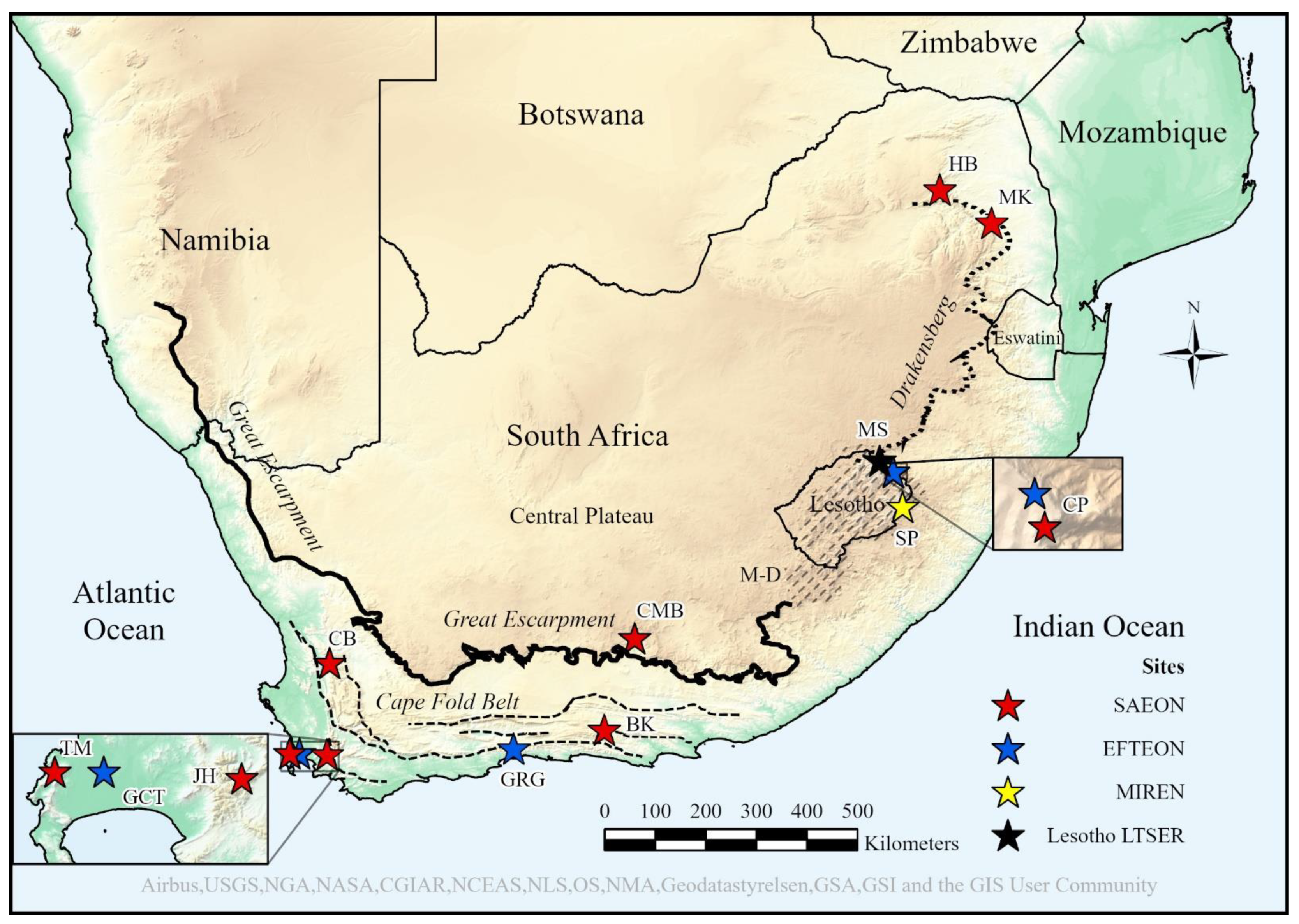
Southern Africa is the southernmost region of Africa. This region is located in the mid-latitudes of the Southern Hemisphere at a tropical–temperate interface, resulting in a heterogeneous landscape and a dynamic climate characterised by strongly seasonal precipitation zones [1]. It has an exceptionally long geologic and climatic history [2] with its Barberton Greenstone Belt in the Makhonjwa Mountains of north-eastern South Africa credited as the oldest mountain range on Earth (ca. 3.2 Ga) [2,3]. Two mountain complexes dominate the region, the Great Escarpment and the Cape Fold Belt. The former is a 5000 km semi-continuous, passive erosional remnant of a receding continental margin stretching from Angola through Namibia, South Africa, Lesotho, Eswatini, Zimbabwe, and Mozambique [2,4] (Figure 1), and bisects the coastal belt from the colder and more seasonal interior [5]. The Great Escarpment arose from the rifting of the Gondwana super-continent and consists mostly of various sedimentary layers of the Triassic Karoo Supergroup overlain by younger basaltic lavas of the Early Jurassic at its highest elevations [6,7]. It covers an elevation range from ±1200–3482 m a.s.l. The significantly older Cape Fold Belt (or Cape Fold Mountains) is a 1300 km fold-and-thrust belt formed by the collision and subductive convergence of tectonic plates during the assembly of Gondwana, and is of Late Paleozoic age. It consists of sedimentary rock layers, mostly quartzitic sandstones and shales of the Cape Supergroup [6,8,9], which form a series of primarily east–west parallel ranges hemmed in between the Great Escarpment and the south-western and southern coastlines of South Africa, covering an elevation range from almost sea level to 2325 m a.s.l. (Figure 1).
Southern Africa’s mountains account for almost half of the world’s broad zonobiomes and a third of the world’s global circulation systems [10]. They traverse a wide climatic gradient that includes subtropical arid (Namibia), Mediterranean (Cape region of South Africa), warm-temperate (eastern South Africa and Lesotho), and semi-arid tropical (Angola, Mozambique, and Zimbabwe) climate types. The Intergovernmental Panel on Climate Change has predicted that the region will be heavily impacted by climate warming [11], placing greater emphasis on our mountains as biodiversity refugia [12,13]. Increased frequency and intensity of droughts and floods, increasing temperatures, and decreased rainfall are specifically predicted, thus defining Southern Africa as a climate hotspot due to its existing vulnerabilities, poor adaptive capacity, under-development, and marginalisation [14]. Knowledge on the governance of climate change at a macro-regional level is lacking [15].
The rich biodiversity and ecosystem services of our mountains lend themselves to ecosystem-based adaptation [16] and nature-based solutions that encompass conservation, sustainable development, and restoration to reduce social and environmental vulnerabilities. Such approaches are critical as we foresee a greater demand for natural resources from our mountain regions [17], as well as greater competition for these resources amongst sectors of society [18]; such increasing pressures on mountain people and natural resources are typical of the developing world [19,20,21,22]. However, interventions aimed at balancing sustainable management of mountain-derived resources and human well-being should have a sound scientific basis in both the natural and social sciences [23,24].
Therefore, some of the most critical data for identifying and quantifying environmental changes, understanding long-term ecosystem dynamics for effective ecosystem management, understanding socio-ecological systems, informing environmental policies, and supporting global policy agendas, are those attached to long time-series from long-term ecological research (LTER) at local, regional, and global scales [25,26,27,28]. LTER is especially important for understanding episodic events (e.g., droughts and floods) and processes such as desertification, land degradation, and climate change, which do not operate over short-terms or small-scales [29,30,31]. Therefore, researchers need to establish high-quality, long-term collaborative and multi-disciplinary research networks aimed at understanding these drivers and patterns of environmental change in a coordinated and multi-site approach [25,26,32]. Two of the world’s exemplary global LTER initiatives are the International Long-Term Ecological Research Network (ILTER) and the Group on Earth Observations Biodiversity Observation Network (GEO BON) [29,31,33]. The building blocks for LTER networks are site-based platforms or “observatories” such as Niwot Ridge (1980–present) in the Colorado Rockies (USA), Cairngorms National Park (2013–present) in Scotland, and Val di Mazia/Matschertal (2008–present) in the Italian Alps [34]. LTER is sometimes expanded to include the human dimension, which acknowledges close coupling between social and biophysical processes. Environmental problem solving should therefore view natural and human systems as a single entity through long-term socio-ecological research (LTSER) [35,36,37].
2. Aims, Materials and Methods
We present the first synthesis of the mountain observatories in Southern Africa and the collective value of long-term research from the region. The primary aim of this novel synthesis was to demonstrate the value of a diverse suite of process-orientated LT(S)ER initiatives in Southern Africa’s mountain regions, framed by making reference to their contribution to human well-being, appropriate management of biodiversity, and environmental sustainability. A synthesis of this nature also generates broader statements gleaned by insight. A secondary aim, therefore, was to identify the strengths and weaknesses in Southern Africa’s mountain-based LT(S)ER framework, and to make recommendations to enhance adaptive capacity and resilience to global change. For the first time, we contextualise the significance of our LT(S)ER from an austral perspective for the international mountain community.
This synthesis was based on an extensive and comprehensive literature review, as well as in-person institutional knowledge, given that both authors are personally involved in a number of these initiatives. Relevant published peer-reviewed scientific literature was sourced through Google®, Google Scholar®, ScienceDirect, and SpringerLink. Unpublished institutional grey literature, particularly from research institutions and governmental departments, and university theses were also consulted. This synthesis included key historical publications dating back to 1948, as well as the full spectrum of relevant literature up to 2021. A total of 164 references were consulted, most of which were then grouped into the focal areas relevant to this study. The literature was heavily focused towards the study area, namely the mountain regions of Southern Africa, but international publications were also cited where studies were relevant or comparisons needed to be made. A comprehensive and diverse set of LT(S)ER initiatives was selected based on objective selection criteria, as follows: (1) representations of the winter, summer, and all-year rainfall regions of Southern Africa; (2) research spanning a range of scales from local plot-scales to landscape-scales; (3) reference to above- and below-ground ecological processes; (4) research representing time frames ranging from earlier pioneering initiatives with significant historical value and long-term data sets to newer initiatives that address contemporary challenges not evident in the past (post-2000); (5) programmes championed by government and academic institutions; (6) inclusion of both montane and alpine elevations; and (7) the need to provide both scientific and practical demonstrative value to ensure a sustainable mountain future. These initiatives are discussed thematically in chronological order. We do not place emphasis on “how long is long-term” as some LT(S)ER initiatives are planned or recently established. They must be long-term by intention at establishment and repeatedly measured. Some of the initiatives refer to long-term monitoring as part of the gradient towards LTER or as part of the LTER framework. Our geographical focus is centred on two of Southern Africa’s dominant mountain complexes, the Great Escarpment and the Cape Fold Belt. Despite the difficultly in defining and delineating mountains leading to different approaches [38], we followed the Global Mountain Biodiversity Assessment definition of mountains based on ruggedness criteria [39].
3. Discussion
3.1. Value of Historical and Current LTER Initiatives
3.1.1. Adaptive Management of Mountain Catchments for Water Security
Water is an essential resource that sustains almost all life on Earth. Southern Africa’s water towers support millions of people in the region [40,41]. While climate scenarios show a significant decline in available water resources, socio-economic trajectories show an increase in water demand [42]. A supply shortfall in a water-scarce region may have social, economic, and environmental repercussions. It is therefore essential to safeguard and monitor our strategic mountain catchments to ensure a steady supply of clean water. South Africa has a history of long-term eco-hydrological research because mountain catchments were earmarked for large-scale afforestation using alien tree species, but the effects of this land use on water supply were unknown [43,44]. The country adopted a multiple-catchment design using entire catchments as experimental units to accommodate physiographic complexity, regarded as a world first [45].
Jonkershoek Valley LTER (“Jonkershoek”; 1935–1992 and 2010–present; with some rainfall gauging commencing in 1925; South Africa) is Africa’s longest running catchment experiment [46]. It is located in a Mediterranean shrubland (“fynbos”) catchment of the winter-rainfall Cape Floristic Region near Stellenbosch in the Boland Mountains of the Cape Fold Belt (Figure 1). It replaced South Africa’s first LTER attempt at Jessievale in the Northern Drakensberg Escarpment (1910–1924), which failed due to lack of funding and poor management [47,48,49]. Jonkershoek uses gauged afforested catchments (and one natural fynbos catchment as the control) to ascertain the effects of afforestation on stream flow [50,51,52] (Table A1). Additionally, fire treatments and wild fires have been used historically to investigate the effects of fire on nutrient budgets [53] and hydrological responses [54,55].
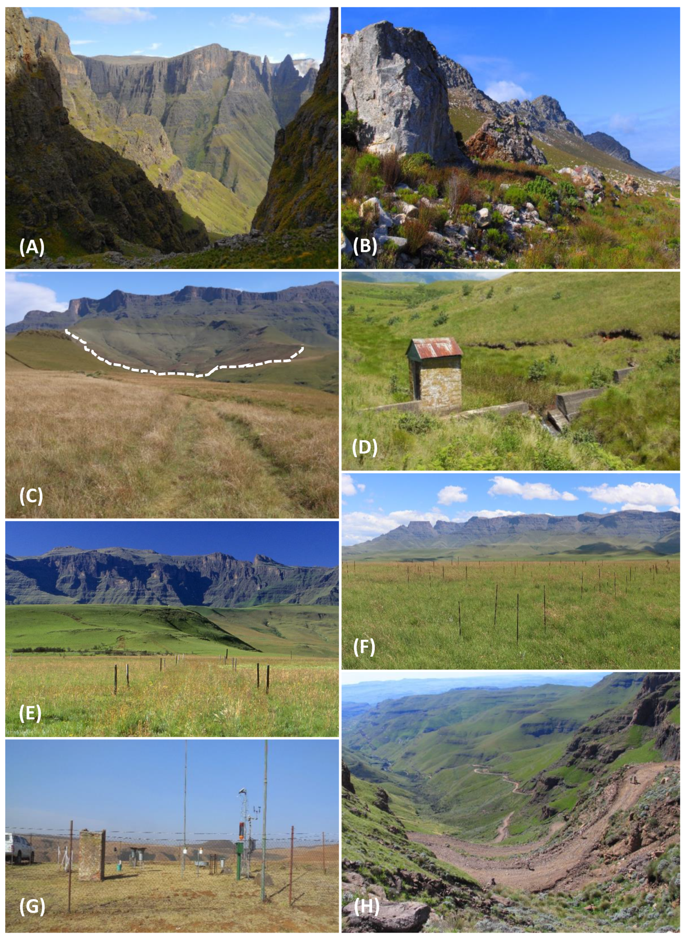
Success at Jonkershoek led to similar LTER in the summer-rainfall Cathedral Peak Research Catchments (“Cathedral Peak”; 1948–1995 and 2012–present; South Africa), part of the greater Cathedral Peak Research Area in the Maloti-Drakensberg region of the Great Escarpment [44,52,56] (Figure 1 and Figure 2). Gauged first-order catchments measure how stream flow in concert with sediment and nutrient exports are impacted by fire regimes in mesic montane grassland, and historically included a grazing and an afforestation treatment with alien trees [56,57,58,59,60] (Table A1).
These examples go far beyond demonstrating the significant impact of afforestation on streamflow and water yield. Wider application by scientists and policy makers to inform national catchment management and water policy in South Africa is arguably the finest example of science-driven policy from LTER in the country. These catchment experiments form the core of globally significant interdisciplinary research programmes that have shaped many environmental policies and practices relating to afforestation, biodiversity, fire, and water [46]. These policies were deconstructed from the late 1980s in favour of the National Water Act, which instead governs water-user rights among competitors. This Act looks past the sustainable management of catchments as ecosystems [49], but may be flexible enough for an adaptive management approach to climate change mitigation [61]. Policy changes often have deleterious knock-on effects. This LTER ceased because the nationally run catchment management programme was decentralised and handed over to conservation agencies in their respective provinces in the late 1980s, who failed to understand its value [49]. Fortunately, the LTER platforms at Jonkershoek and Cathedral Peak were resurrected from 2010 and 2012, respectively, under the gamut of the South African Environmental Observation Network (Table A1). They have evolved from long-term eco-hydrological monitoring platforms [62] to global change observatory catchments, encouraging more multi-disciplinary research using high-tech instrumentation [46]. Their value lies in understanding which land uses and management practices best support and optimise water supply in these sensitive and critical water supply areas, together with understanding the potential negative global change impacts. This knowledge is essential to building a resilient water tower and ensuring an adaptive management approach to water conservation in a water-limited region [62].
3.1.2. Fire Management and Policy That Optimises Grassland Biodiversity, Resilience and Water Production
Unlike the vast treed montane landscapes in many parts of the world [63,64], Southern Africa’s mountains are covered largely by ancient, old-growth grasslands and shrublands. These highly flammable ecosystems have co-evolved with fire for hundreds of thousands of years [21,65], making fire one of the main ecological drivers and management tools [66]. Management objectives aimed at maintaining the stability of montane grasslands therefore need to incorporate their dynamic nature in response to fire [67]. Application of fire at the correct frequency and season is essential for optimising grassland biodiversity and condition, which minimises erosion and sediment losses to maintain a steady supply of clean water and maximise storage of soil organic carbon to mitigate climate change [68,69].
To understand these dynamics long-term, the Brotherton Fire Experiment (1981–1992 and 2015–present; South Africa; Figure 2) at Cathedral Peak in the Maloti-Drakensberg was established as a small-scale mesocosm-type fire experiment using 1-, 2-, 5-, and 12-year fire-return interval treatments to complement the larger research catchment-scale fire experiment discussed previously [69,70,71]. The experiment is generally sampled biennially, but occasionally on an ad hoc basis [71,72,73]. In 2004, a multi-disciplinary team of scientists used the fire experiment to convince the management authority of its importance by including a broader suite of biodiversity elements and the potential for climate change research [73].
The original aim was to assess the effects of pyrodiversity (varied fire frequency and seasonality treatments) on mesic montane grass structure (basal cover) and composition (diversity) [72], but has been expanded to test the effects of fire on forb species composition and diversity [66], soil properties and landscape functioning [74], invertebrate diversity and abundance [75], and multi-decadal changes in grass and forb species composition in concert [69,70]. It also hosts a warming experiment using open-top chambers [76]. All of these metrics are important indicators of grassland health [77] and biodiversity value [66]. Data from the long-term fire experiment are used to inform optimal burning practices in the Maloti-Drakensberg, established as regular biennial burning in the dormant season [69], supplemented with smaller patch burns at slightly longer fire-return intervals [70]. Biennial burns in late winter or early spring maintain grass bud banks and important grass species at desired levels of abundance [69,78] to ensure a long-term desired state of grassland equilibrium and stability that can resist change and maintain healthy and resilient grassland communities [69,78,79] and water towers [67,69]. Slightly longer fire-return intervals enhance plant diversity [70]. It has also been shown that excessively longer fire-return intervals (5–13 years) will shift grassland species composition and decrease vegetation cover, leading to greater soil exposure [69].
Although fire has rarely been included in experimental climate change research [76], the fire experiment will also provide a valuable means to detect and understand future responses to climate change as plant species are likely to shift their ranges, seasonal growth patterns, and responses to fire under changing mountain climates [69,76]. Understanding how montane grasslands will respond to climate change and associated changes in a fire regime is essential for protecting its profound biodiversity and functional value [76]. Such knowledge is now being entrenched as standard policy in the Integrated Management Plan and Fire Management Plan of the Maloti-Drakensberg Park World Heritage Site (in which this LTER site is located) [80] and in the management of mesic grasslands in general [81]. Such a fire experiment could also potentially inform the safest conditions under which to conduct controlled burning of fire-breaks and fire suppression, to limit the spread of life-threatening extreme fire events common to the Maloti-Drakensberg [68].
3.1.3. Resuscitating the National Government LTER Platform in South Africa
LTER rose to greater prominence in the South African scientific community in the mid-1990s, driven by renewed global interest in measuring anthropogenic climate change and concern for the socio-economic impacts of environmental stressors at scales and complexities not seen before. A national workshop in 1999 discussed prompts by the ILTER to establish a similar research network in South Africa, with particular focus on climate change and ecology [30,44,82,83,84].
The mandate of this emergent government-funded South African Environmental Observation Network (SAEON; 2002–present) is to understand human-induced global change impacts on the environment and ecosystem services and provide meaningful data for policy makers to manage South Africa’s natural capital sustainably in a changing world [85]. SAEON maintains a network of platforms in both terrestrial and marine environments across South Africa. These platforms constitute long-tern research sites where repeated observations, experimental treatments, and related data are permanently maintained. SAEON is part of the Environmental Observatories Network (EON) and shares links with the Environmental Long-Term Observatories Network of Southern Africa (ELTOSA), designed to synergise LTER at a regional level, and the ILTER [82,86]. SAEON has partnered with academic institutions and other research facilities to rapidly engage an already institutionalised network to achieve a quick uptake in both scale and time. It makes use of historical platforms as well as establishing its own. SAEON operates as a number of research nodes distributed across the country’s various zonobiomes, each anchoring participatory sites that serve as research stations and environmental change observatories. There are eight SAEON mountain observatories (four in the Cape Fold Belt and four in the Great Escarpment; Figure 1 and Table A1). SAEON has been instrumental at resurrecting earlier floundering government LTER programmes, for example at Jonkershoek and Cathedral Peak.
3.1.4. Early Detection of Mountain Invasive Alien Plants and Understanding Species Redistributions
Invasive alien plants are among the foremost threats to biodiversity on the planet [87,88]. The mountain regions of Southern Africa have not been spared this fate [89,90,91,92]. Some areas are accessible by road passes and are therefore highly susceptible to invasions due to anthropogenic disturbance and sustained propagule pressure [91,93,94]. This invasion threat necessitated a long-term intervention, and presented the opportunity for local actors to collaborate with the international Mountain Invasion Research Network (MIREN), established in 2005 as an initiative of the Global Mountain Biodiversity Assessment [89,95]. MIREN initially monitored the impacts of non-native plant invasions in mountains across the globe [95], but has expanded its focus to include the broader effects of global change on plant species’ redistributions in mountain regions [27,96]. A sub-component, RangeX, seeks to understand the mechanisms and impacts of plants expanding their ranges due to climate warming [97]. These international programmes, with almost 30 participatory sites, are poorly represented in the Southern Hemisphere. Only eight sites are collectively represented by the Australian Alps, Southern African Maloti-Drakensberg, and South American Andes (Argentina, Chile, and Ecuador) [98]. Africa in particular is poorly represented; the second MIREN site is located in the Atlas Mountains of Morocco [98]. The region’s first MIREN site, in the Maloti-Drakensberg, was established at Sani Pass, connecting South Africa with Lesotho (2007–present; Figure 2, Table A1) [89,91], and was later extended up into Kotisephola Pass in Lesotho [91]. Expansion of the MIREN network in the region is currently being facilitated through the Afromontane Research Unit of the University of the Free State at three sites ranging from montane to alpine elevations: Witsieshoek Pass and Sentinel trail, Cathedral Peak (Mike’s and Organ Pipes Passes), and additional sites at Sani Pass in the Maloti-Drakensberg [99]. This LTER serves as an effective early detection strategy to mitigate the threat posed by alien plants [100] and helps understand how invasive alien plants and other range-expanding species are impacting biodiversity and ecosystem functions along elevation gradients, which, as competitors, are influencing species’ responses to climate change through the establishment of novel communities [101,102].
3.1.5. Understanding the Effects of Nutrient Enrichment on Biodiversity and Livelihoods
The Anthropocene is marked in part by rapid changes to global nutrient budgets and the abundance and identity of consumers [103]. To quantify these global impacts, the Nutrient Network (NutNet; 2005–present) [104,105] has spread from the USA to about 130 grassland-dominated sites across the world [106]. This collaborative, distributed LTER network uses standardised methods to examine the relationship between two fundamental ecosystem properties on which ecosystem- and human-health both depend, namely diversity and productivity [105,107,108]. A primary effect of climate change on mountain ecosystems is shifts in species’ distributions, diversity, and system productivity [109,110]. A mechanistic understanding of the diversity−productivity relationship is therefore fundamental to understanding how species dynamics shape community processes [103,111,112], which in turn can predict the conditions under which species can either buffer or exacerbate global change [103].
The NutNet site at Cathedral Peak in the montane belt of the Maloti-Drakensberg (2018–present; South Africa; Figure 2) is one of only two high-elevation sites in Africa, and is the only NutNet site within the geographical scope of this study. Similar to other LTER programmes covered in this synthesis, NutNet is poorly represented in the Southern Hemisphere, Africa, and the region. A NutNet site in the Maloti-Drakensberg is highly relevant because a long-term nutrient addition experiment manipulating multiple nutrients will be highly informative in a nutrient-limited system. Although basalt-derived soils of the Maloti-Drakensberg are intrinsically nutrient-rich (especially total carbon and nitrogen), they have a low nutrient availability due to highly constrained microbial activity mediated by cool temperatures and other soil-related factors [113]. Climate warming, leading to enhanced microbial activity and therefore increased nutrient availability, is expected to have a deleterious impact on the nutrient-limited flora of the Maloti-Drakensberg [114]. Additionally, atmospheric deposition of nitrogen and sulphur leading to ecosystem acidification is a further cause for concern. For example, Cathedral Peak in the Maloti-Drakensberg has the highest annual wet deposition fluxes of nitrogen (NO3− and NH4+) and sulphur (SO42−) of any sites monitored in eastern South Africa [115]. High rainfall and recirculation patterns characteristic of a background site located downwind of large industrial areas are the most likely factors [115]. It is important to establish an additional site in the alpine belt of the Maloti-Drakensberg as the effects of nutrient enrichment through warming and deposition on a nutrient-limited alpine flora at this elevation are unknown. Furthermore, as some of our mountains are important rangelands supporting the livelihoods of shepherds practicing transhumance pastoralism [21], it is also important to gauge the potential effects of nutrient enrichment on the dynamics of grazed herbaceous systems.
3.2. Value of LT(S)ER Initiatives Under Development
3.2.1. Understanding How Climate Warming Will Affect Sensitive Alpine Habitat: An Austral Perspective
Although the alpine biome is represented across all continents and latitudes [116], it only covers about 3% of the Earth’s terrestrial surface outside Antarctica [117]. Since 2001, the Global Observation Research Initiative in Alpine Environments (GLORIA), acknowledging the highly sensitive nature of alpine systems and their vulnerability to climate warming [118,119], established long-term alpine observatories across the globe for the comparative study of climate change impacts on mountain vegetation and its biodiversity [120,121]. A clear pattern has emerged in the distribution of GLORIA sites across the globe. Most are concentrated in the Northern Hemisphere (especially Europe, North America, and the Himalayas) [10]. While this may be in part due to the global alpine biome being far more represented in the Northern than the Southern Hemisphere [117], it also speaks to other factors such as historical bias, disparity in funding, and a historical disconnectedness between Northern and Southern actors. Interrogation of the Dynamic Ecological Information Management System (DEIMS) [34,122] revealed only 3% representation of alpine LTER-type sites from the Southern Hemisphere (viz. Australia, Bolivia and Ecuador; it is not known why the two New Zealand GLORIA sites do not appear in this database). This imbalance undermines the ability of GLORIA (and other LTER programmes) to generate representative data across all zonobiomes and global circulation systems. There are only two active GLORIA sites in Africa, in the Rwenzori Mountains and Mt. Elgon [123], both of which are located in Uganda in the Northern Hemisphere.
The upper reaches (ca. 2800–3482 m a.s.l.) of the Maloti-Drakensberg host the only alpine environment in Southern Africa [124] and the only alpine environment south of Mount Hanang in Tanzania, East Africa. It is small on a global scale (<12,000 km2) [20] and poorly known from an international perspective. For example, key global alpine analyses did not include the alpine Drakensberg [125,126]. An exception included its inselberg alpine summits [127], which unfortunately are not representative of the “mainland” escarpment plateau due to their small size, and because of their almost free-standing nature, are spared the threats of livestock grazing, alien plants, and plant harvesting [128].
Africa’s tropical and southern alpine systems are highly divergent biologically [21], and therefore necessitate separate LTER initiatives to measure potentially dissimilar responses to global change. Attempts were made by Prof. Stefan Grab from Wits University and the first author from 1999–2004 to redress the absence of GLORIA sites in Southern Africa and the paucity of sites in the Southern Hemisphere. Lesotho, supporting 90% of Southern Africa’s alpine habitats [21], was chosen for this purpose. Support was provided in 2004 by a small New Zealand delegation from the University of Otago. The summits of Kotisephola Pass and Black Mountain were scouted in particular due to their accessibility. No suitable sites were located due to security concerns for equipment and inability to fulfil the multi-summit approach [121] due to topographic constraints. New localities are being sought by the Afromontane Research Unit of the University of the Free State, most likely in their planned Mont-aux-Sources LTSER node in the north-eastern Maloti-Drakensberg. Alternative possibilities in the Maloti-Drakensberg being considered are Letšeng diamond mine (Lesotho) and Ben Macdhui (Tiffindell Ski Resort; South Africa) [99]. In addition to understanding the effects of climate warming on a poorly known alpine flora, GLORIA sites in Southern Africa will ensure a more comprehensive and robust network by adding representations from the subtropic-alpine biome and maritime subtropical monsoon regional climate system in the mid-latitudes of the Southern Hemisphere, currently highly under-represented in the GLORIA network.
3.2.2. Soil Knowledge for the Management and Conservation of Soil Resources to Sustain Livelihoods and Safeguard Biodiversity
Soils are significant storehouses of global terrestrial biodiversity, which fulfil multiple critical ecosystem functions and services such as climate regulation, nutrient cycling, and food production [129,130,131]. Few long-term global soil biodiversity studies have been undertaken, leading to a lack of policies to support soil biodiversity conservation and governance [130,131]. Sustainable livelihoods in Southern Africa’s mountains will depend heavily on well managed and conserved soil systems to support crop and livestock production. Unfortunately, populated areas in the Maloti-Drakensberg, for example, are degraded and not sustainably managed for food security [17,21]. Soil biodiversity is therefore under pressure from human activities [130]. Long-term studies relating to soil structure, fertility, and biodiversity are essential to optimising food production and ensuring environmental sustainability in the region. However, soil studies in the mountains of Southern Africa are limited, generally small-scale, and mostly non-repetitive [74]. The recently launched global Soil Biodiversity Observation Network (Soil BON), a thematic LTER network within GEO BON, aims to understand how changes to soil biodiversity and ecosystem function may affect the ability of people to sustainably manage and conserve soil resources to support livelihoods and safeguard soil biodiversity [132]. It is essential that the region is linked to this critically important international LTER programme and has a number of representative sites in its mountains. For this reason, a Soil BON site has been proposed for Cathedral Peak in the Maloti-Drakensberg, where paired sampling sites along a land use and degradation gradient ranging from protected area to communal land can be established.
3.2.3. Moving Towards Systems-Based, Landscape-Scaled LTSER
The region has an extremely poor track record with mountain-based LTSER, a great injustice given how important these mountains are to people. Perhaps the reason is because most long-term research in our mountains has historically taken place in sacrosanct protected areas managed for conservation, without having to take cognisance of a social context. People were simply fenced out. The world has changed significantly, and social dynamics are requiring formal integration given the complex social issues around land tenure, communal land practices, and degradation, as well as greater need for sustainability, food security, and more holistic management of socio-ecological systems. Southern Africa’s third-world context necessitates a sensitive and strategic approach to addressing change in its mountain regions. Embracing its social environment through social engagement [133], public-assisted monitoring [32], and the crafting of innovative solutions for mountain futures [134] are key features to consider in future LTSER, given that mountains and their associated ecosystem services are critical for people [24,41,135,136] and are cradles of cultural and ethnic diversity [137,138]. The first pioneering form of mountain LTSER in South Africa took place in the impoverished rural Okhombe and Obonjaneni communities in the upper Tugela catchment of the northern Maloti-Drakensberg [139]. Individual projects were highly varied, ranging from erosion control monitoring of degraded catchments to implementing and monitoring intercropping systems for enhanced ecosystem services and food security [140]. There is a key need for South Africa to capacitate and support LTSER initiatives with its neighbours, particularly where mountains are shared by adjacent countries (e.g., South Africa–Lesotho).
SAEON’s highly networked infrastructure footprint has paved the way for a new ecosystems-based, socio-ecological initiative currently being established through the Expanded Freshwater and Terrestrial Environmental Observation Network (EFTEON; South Africa). This LTSER infrastructure comprises six socio-ecological “landscapes” accommodating gradients of land transformation to clarify the complex relationships between ecosystems and socio-dynamic systems under climate change [141]. Three EFTEON landscapes encompassing mountain environments are being established. The northern Maloti-Drakensberg EFTEON landscape proposes to make use of Cathedral Peak (Table A1), already a designated focal research and monitoring site in a protected area, as the “anchor tenant” from which to extend research infrastructure into lowland areas of both commercial and subsistence agriculture. The socio-economic and environmental importance of the Cathedral Peak area together with its geographic complexity and sensitivity to climate change inherent in a mountainous area makes it the ideal candidate for large-scale systems-based research [62]. Specifically, steep transformation gradients from almost pristine protected areas to degraded and impoverished community areas [142,143], a long historical record of meteorological and hydrological data [56,144], and its location in a transition area from C3 to C4 grassland and grassland/savanna count heavily in its favour for LTSER [145].
The second proposed EFTEON landscape, the Greater Cape Town (GCT) landscape, will link the Atlantic Ocean with the Boland Mountains Strategic Water Source Area in the Cape Fold Belt, covering steep climate and vegetation gradients in the Fynbos Biome. This environmental gradient traverses a rich socio-cultural footprint, which includes urban, agricultural, and natural land use types. The Table Mountain National Park (“Table Mountain”) and Jonkershoek observatories are proposed components of this landscape [145] (Table A1). This landscape offers a direct link to the BioGrip Cape Point Atmospheric Monitoring (Global Atmospheric Watch) and Cape Town South African Population Research Infrastructure Network sites [145].
The third proposed EFTEON landscape of relevance is the Garden Route Gateway (GRG), which will be centred on short-reach, high-energy river systems draining the Baviaans and Kouga Mountains of the Cape Fold Belt into the Indian Ocean through an area of rapid urbanisation and agricultural intensification. The Baviaanskloof observatory is a proposed component of this landscape (Table A1). Both the GCT and GRG landscapes present source-to-sea opportunities involving upstream and downstream systems, which link terrestrial mountain catchments with marine ecosystems [145].
3.3. What about the Rest of Southern Africa?
South Africa has the most active and comprehensive LTER networks in the region. Other Southern African countries have limited long-term meteorological (rainfall and air temperature) and hydrological monitoring but it is not mountain-focused (see [146,147,148,149,150]). Two exceptions relate to Lesotho: a high-elevation rainfall and temperature series [151] and the MIREN programme (discussed previously). This almost absence of mountain LTER outside of South Africa is largely due to the region’s remote and inaccessible complex terrain, shortage of institutional and human capacity, lack of funding, theft and vandalism of equipment, and poor data management systems [62,83,151,152].
One key intervention intended to facilitate LTER across Southern African countries was the ELTOSA network established in 2001. It aimed to connect member country EONs to study ecosystems and environmental issues traversing political borders [30,82,83], but has failed to materialise. A recent global review shows only South Africa and Namibia hosting LTER in the region—based on DEIMS, July 2017 [28]. The Namibian site, however, bears no relevance, as its research station is located in the Namib Desert. Failure to successfully implement a transnational network highlights the challenges of undertaking LTER in the region, hampered by pervasive funding constraints and lack of institutional capacity (both human and infrastructure) [30,82]. Fortunately, the African Mountain Research Foundation (AMRF), progeny of the International Mountain Society, was recently established to catalyse and extend LTSER beyond South Africa into the mountain regions of Angola, Lesotho, Madagascar, Malawi, Mozambique, Namibia, and Zimbabwe. It is essentially a fund-raising arm to establish LTSER with the Afromontane Research Unit of the University of the Free State as its beneficiary [153]. Previously, AfroMont (Research Network on Global Change in African Mountains) supported collaborative research in African mountains, but is now largely defunct.
3.4. Local Knowledge with Global Significance
This synthesis has enabled us to highlight the strengths and weaknesses of our mountain observatory networks (Table 1) and to underscore the collective value of our mountain-based LT(S)ER in terms of how it safeguards people and biodiversity for a sustainable mountain future. It also allowed us to contextualise and frame the significance of our mountain-based LT(S)ER from an austral perspective for the Northern Hemisphere-dominated international mountain community. This opportunity is essential to balancing the global narrative around how mountain people and biodiversity may be impacted by a rapidly changing world and can hopefully present workable solutions which may benefit other mountainous countries facing similar challenges.
Insights gained from our LT(S)ER offer a unique perspective due to our local mountain context, outlined as follows: (1) our mountains are not very high in elevation by global standards and do not occur at high latitudes. They therefore have no permanent snow and ice, no upper-alpine and nival zones, and no glaciers, suggesting that detecting changes may require a more subtle and nuanced approach (only periglacial signatures are present at the highest elevations). (2) Our mountains are not covered with montane forests and lack the characteristic alpine treeline tracking the 6 °C seasonal mean isotherm between alpine and montane belts [63,64], which as a thermal “marker” sensitive to climate warming can be used as an indicator of change. In Southern Africa’s Maloti-Drakensberg, a more obscure treeline ecotone is depressed by almost a 1000 m due to a precipitous escarpment; this discontinuous treeline ecotone separates the upper-montane and lower-montane belts [114]. Changes here may not be as easily detected compared with the alpine treeline at higher elevation. (3) True to the global trend of mountain plant diversity peaking in the mid-latitudes [127], our mountains are hyper-diverse palaeo-centres of plant diversity and endemism. This diversity is largely accounted for by expansive and ancient old-growth grasslands and shrublands [124,154,155,156]. In contrast, our montane forests are small patches (1–10 ha) on south- and south-east facing slopes and in steep-sided valleys; they are species-poor with low levels of endemism [124,157]. (4) There are few examples of mountains located in the Southern Hemisphere mid-latitudes (together with the Australian Alps and central South American Andes), strategically positioned at a tropical–temperate interface, where warming and precipitation changes are expected. (5) The Great Escarpment and Cape Fold Belt are the region’s most significant climate regulators–topographic influences that exert strong regional and micro-scale controls on precipitation, humidity, airflow and temperature [2]. (6) Our mountains include Africa’s only non-tropical, Southern Hemisphere alpine habitat, and its small area and relatively benign relief by global alpine standards may offer alpine species under climate change fewer opportunities to migrate due to a limited mosaic of micro-habitats and thermal niches (see [158]). (7) Our mountains are characterised by strong moisture/aridity, temperature, and aspect gradients, and include almost half of the world’s zonobiomes and a third of the world’s global circulation systems. (8) Our montane grasslands are beginning to show different responses to climate change when compared with Northern Hemisphere systems [76]. (9) Our mountains are some of the oldest on the planet with interesting and complex geologic and geomorphic histories, with less of the “continental” influence experienced by Northern Hemisphere mountains. (10) Our mountains have their own unique Quaternary glaciation history [159] and are believed to have been affected by late Quaternary climatic fluctuations [5,160]. (11) Our mountains host a sovereign country (“the Mountain Kingdom of Lesotho”) entirely enclaved by South Africa; this is the only Southern Hemisphere example of an enclaved country and the only country in the world occurring in its entirety above 1000 m a.s.l. [161]. A nation accommodated entirely within a mountain context places extreme pressure on its natural resources—Lesotho’s mountains are occupied by pastoralists with heavy dependence on communal rangelands, leading to landscape degradation and unsustainable resource use [21]. (12) In addition, there are still many learning opportunities to be experienced and lessons to be shared amongst a diverse suite of stakeholders in the building of a multi-disciplinary, multi-scale community of practice [27] to undergird adaptation and resilience policy.
4. Conclusions
Southern Africa has the opportunity to host comprehensive mountain observatory networks that will contribute towards a more holistic and robust global network of mountain observatories inclusive of all relevant sciences. We conclude with a few recommendations to further capacitate Southern Africa’s ability to manage its mountain systems sustainably and in a way that builds resilience to global change: (1) LT(S)ER should have its own unique flavour formulated around the region’s socio-ecological realities, context, agendas, and policy frameworks. (2) The nations of the region not engaging in LT(S)ER should be encouraged to invest in a research infrastructure framework to advance their scientific footprint and skills base, and more importantly to understand global change impacts. (3) The smaller mountain complexes not part of the Great Escarpment, such as the Lebombo Mountains, Soutpansberg and Waterberg, may also warrant some attention in the future to ensure a more comprehensive understanding of our mountain systems. (4) The socio-ecological and socio-economic dimensions involving sustainable livelihoods, resource use, ethnic diversity, and culture linked to mountains need to be urgently incorporated in to LTER initiatives (LTSER). The establishment of the EFTEON landscapes in 2021 is a large step towards achieving this end. (5) Effective, clean governance is critically important to ensure sustainability, conserve natural resources and safeguard human well-being [163]. (6) Furthermore, global collaborations are key to tackling pressing global change issues that traverse spatial and temporal scales and require multi-disciplinary inputs across many fields. SAEON and the Afromontane Research Unit in particular are ensuring collaboration within the broader scientific community, with growing international partnerships emerging in the past few years. A few suggestions to foster deeper international connections include the hosting of appropriately themed mountain conferences (such as the first Southern African Mountain Conference 2022), focused workshops, greater use of digital resources to host online events, Special Issue journal publications, increasing the global visibility of international networks to grow membership across all hemispheres and disciplines, sabbaticals taken abroad, and more generally the reciprocal exchange of visiting delegations between countries. A good opportunity for synergistic interactions exists between the proposed Northern Maloti-Drakensberg EFTEON landscape and the Mont-aux-Sources LTSER node. (7) LT(S)ER in South Africa should continue to receive funding given its long LTER history, previous financial investments, long-term data legacies, and active strides being taken to advance its scientific infrastructural footprint. (8) LT(S)ER should be adaptive in nature, always seeking to remain relevant and supple enough to meet changing research questions and needs. It should also be designed with the end user in mind to inform “evidence-based policy” [26] primed for implementation. (9) Future placement of LT(S)ER sites to close knowledge gaps will require novel approaches, given that they may have to be located in remote and inaccessible areas that are difficult to establish and administer. (10) We have demonstrated the value of our LT(S)ER along thematic lines of research, however, they may obscure and limit our ability to characterise and mitigate global change impacts until they have been integrated through a holistic approach [162]. Our greatest challenge will be to integrate data from multiple thematic programmes into a single, clear mountain-specific adaptation policy for implementation. Smaller, focused steps will therefore be required to achieve this end. Since we already have water and fire policy informed by multi-decadal catchment and burning experiments respectively, a “nutrient policy” should also be established in the future that incorporates management interventions addressing the nutrient-enrichment impacts of global change on our mountain grasslands. (11) The current establishment of mountain observatories relating to the GLORIA, RangeX, Soil BON, MIREN, and AMRF programmes and the proposed EFTEON landscapes makes for an exciting new chapter of LT(S)ER in Southern Africa and an invaluable contribution to the international mountain community. This renaissance period is timeous given the many perils and pressures facing our mountain people and biota in the Anthropocene. It is therefore essential that LTSER generating high-quality data is conducted in the mountain regions of this uniquely positioned region of the Earth, whose context is largely unreplicated in other mountain regions of the world. This is our mountain watch for a sustainable Southern African mountain future.
Author Contributions
Funding
The authors did not receive special funding for this study. However, this paper is an expansion of an oral presentation delivered by the first author at a workshop (“Contribution of Long-term Ecological Research Programs in Mountains to Global Policy Agendas and UN Conventions”) hosted by the Global Mountain Biodiversity Assessment in Champex, Switzerland. The organisers are thanked for sponsoring this workshop.
Acknowledgments
We thank Tim O’Connor for a critical review of the first draft. Ralph Clark (Afromontane Research Unit) is thanked for permission to mention the African Mountain Research Foundation. Rion Lerm (SAEON) is thanked for assistance with Figure 1. We thank two anonymous reviewers for constructive inputs.
Conflicts of Interest
The authors declare no conflict of interest.
Appendix A

Table A1.
Summary of the mountain observatories in Southern Africa. Atmospheric and hydrological research is included in the broader LTER framework to showcase the full suite of parameters measured long-term. Key environmental change drivers † and response variables * are indicated for each observatory [164]. Date ranges start with the earliest instrumentation/infrastructure for at least one of the data parameters listed. Mid-range dates are shown where the South African Environmental Observation Network (SAEON) resurrected earlier data collection. Data collection and recording frequency vary with changes in stations, instrumentation, or custodianship of the research platform. Elevation range at each observatory reflects the spread of data collection activities, not necessarily the topographic extremes (with the exception of the Mont-aux-Sources and Sani Pass sites).
| Site and Affiliation | Mountain Range and Country | Management Authority | Biome and Rainfall Zone | Recorded Parameters and Attributes | Elevation Range (m a.s.l.) |
|---|---|---|---|---|---|
| Cape Fold Belt | |||||
| Baviaanskloof SAEON Fynbos node; proposed component of the Garden Route Gateway EFTEON landscape | Baviaans and Kouga Mountains, South Africa | Eastern Cape Parks and Tourism Agency | Intersection of Albany Thicket, Succulent Karoo, Fynbos; winter rainfall | Atmospheric parameters (2011–2015–current): air temperature, vapour pressure deficit, atmospheric pressure, precipitation, wind speed and direction Hydrological parameters (2012–current): groundwater and surface water elevation, depth and temperature, estimated streamflow Ecological parameters: vegetation surveyed in 1991/1992 and 2011/2012 † Land use/cover; disturbance; water abstraction * Hydrological functioning; biodiversity Baviaanskloof is affiliated with the Global Ecosystem Research Infrastructure (GERI) and the International Long-Term Ecological Research Network (ILTER). It is a LivingLands landscape and falls within the UNESCO Cape Floral Region Protected Areas World Heritage Site | 174–985 |
| Cederberg SAEON Fynbos node | Cederberg Mountains, South Africa | CapeNature | Fynbos, Succulent Karoo; winter rainfall | Atmospheric parameters (2015–current): air temperature, relative humidity, wind speed and direction, precipitation, solar radiation, atmospheric pressure Ecological parameters: vegetation relevés surveyed in the 1980s, targeted floral species monitoring † Climate change; disturbance * Biodiversity | 1310–1576 |
| Jonkershoek Valley (”Jonkershoek”) SAEON Fynbos node; proposed component of the Greater Cape Town EFTEON landscape | Boland Mountains, South Africa | CapeNature | Fynbos, Afrotemperate forest; winter rainfall | Six gauged research catchments (five afforested with Pinus radiata + one control) Atmospheric parameters (1925–2013/2014–current): atmospheric pressure, precipitation, air temperature, fog, vapour pressure, dew point temperature, relative humidity, wind speed and direction, net radiation, leaf wetness; (2019–current): CO2 and H2O flux, short- and long-wave incoming and outgoing radiation, albedo, soil heat flux Hydrological parameters (1935–1992; 2010–current): runoff amount, surface water level, quality and temperature; (2013–current): soil moisture Ecological parameters: plant species turnover † Climate change; land use/cover; disturbance; alien organisms * Hydrological functioning; biogeochemical cycling Jonkershoek is affiliated with the GERI, ILTER and the TRY plant trait and BioTIME global databases and falls within the UNESCO Cape Floral Region Protected Areas World Heritage Site | 239–1214 |
| Table Mountain National Park (”Table Mountain”) SAEON Fynbos node; proposed component of the Greater Cape Town EFTEON landscape | Cape Peninsula Mountains, South Africa | South African National Parks | Fynbos, Afrotemperate forest; winter rainfall | Atmospheric parameters (1962–2013–current): precipitation, air temperature, fog, atmospheric pressure, net radiation, relative humidity, wind speed and direction, leaf wetness, and soil temperature Hydrological parameters (2013–current): soil moisture Ecological parameters: vegetation relevés surveyed in 1966, 1999 and 2010 † Climate change; land use/cover; alien organisms * Hydrological functioning; biodiversity Falls within the UNESCO Cape Floral Region Protected Areas World Heritage Site | 40–966 |
| Great Escarpment | |||||
| Cathedral Peak Research Catchments (”Cathedral Peak”) SAEON Grasslands–Wetlands–Forests node; proposed component of the Northern Maloti-Drakensberg EFTEON landscape | Maloti-Drakensberg, South Africa | Ezemvelo KwaZulu-Natal Wildlife (previously Natal Parks Board, Department of Forestry/Forestek/Council for Scientific and Industrial Research) | Grassland; summer rainfall | Fifteen gauged research catchments (13–190 ha); one excluded from fire; one historically afforested with Pinus patula and one historically grazed by cattle Atmospheric parameters (1949–1995; 2012–current): atmospheric pressure, precipitation, dew point, relative humidity, air temperature, vapour pressure deficit, suspended solids, wind speed and direction, net radiation; (2019–current): CO2 and H2O flux, short- and long-wave incoming and outgoing radiation, albedo, and soil heat flux Hydrological parameters (1948–1995; 2013–current): surface water level, quality, temperature and volume, soil moisture Ecological parameters: vegetation relevés surveyed in 1975 and 1985 and by SAEON in 2013 † Climate change; land use/cover; disturbance * Hydrological functioning; biodiversity; biogeochemical cycling ** Long-term automated weather station and fixed camera vegetation monitoring site on an alpine inselberg summit near Vulture’s Retreat Cathedral Peak is affiliated with the GERI and ILTER. The site falls within the UNESCO Maloti-Drakensberg Park World Heritage Site The Research Catchments are located within the Cathedral Peak Research Area which also hosts the multi-decadal Brotherton Fire Experiment (BFE), a Nutrient Network (NutNet) site as well as planned Soil Biodiversity Observation Network (Soil BON) and Mountain Invasion Research Network (MIREN) sites | 1820–2463 3010** |
| Compassberg SAEON Arid Lands node | Sneeuberge, South Africa | Compassberg Protected Environment Group and SAEON | Nama-Karoo, Grassland; autumn rainfall | Atmospheric parameters (2016–current): precipitation, air temperature, relative humidity, wind speed and direction, net radiation, atmospheric pressure, leaf wetness, and soil temperature Ecological parameters: vegetation relevés surveyed in 2014 and 2016 † Climate change * Biodiversity | 1200–2502 |
| Haenertsburg SAEON Ndlovu node | Limpopo Drakensberg (Wolkberg section), South Africa | Limpopo Department of Economic Development, Environment and Tourism | Grassland, Savanna, Afrotemperate forest; summer rainfall | Atmospheric parameters (2014–current): air temperature, relative humidity, wind speed and direction, precipitation, net radiation, atmospheric pressure, and fog Ecological parameters: vegetation relevés surveyed triennially 2007–current, targeted floral species monitoring, high-resolution aerial imagery † Climate change; land use/cover; disturbance * Biodiversity | 1350–1459 |
| Mariepskop SAEON Ndlovu node | Mpumalanga Drakensberg, South Africa | Department of Forestry, Fisheries and the Environment/ Mpumalanga Tourism and Parks Agency | Grassland; summer rainfall | Atmospheric parameters (2000–current): air temperature, precipitation, fog Hydrological parameters (2019–current): water level, quality, temperature and volume Ecological parameters: vegetation relevés surveyed triennially 2018–current, high-resolution aerial imagery, fish composition (2012/2013, 2021) † Climate change; land use/cover; disturbance; water abstraction * Hydrological functioning; biodiversity Gazetted for inclusion in the Blyde River Canyon Nature Reserve | 710–1947 |
| Mont-aux-Sources LTSER node Afromontane Research Unit, University of the Free State [99] | Maloti-Drakensberg, South Africa and Lesotho | Ezemvelo KwaZulu-Natal Wildlife and Ingonyama Trust (South Africa); Basutho Royal Houses (Lesotho) | Grassland; summer rainfall | ca. 1200 km2; establishment in progress; will include Global Observation Research Initiative in Alpine Environments (GLORIA) and Mountain Invasion Research Network (MIREN)/RangeX sites † Alien plants; climate change; land-use change; degradation; disturbance * Biodiversity; livelihoods The site falls partly within the UNESCO Maloti-Drakensberg Park World Heritage Site (Royal Natal section) | 1300–3282 |
| Sani Pass (South Africa) and Kotisephola Pass (Lesotho) Stellenbosch University; University of Johannesburg; University of Pretoria [89,91] | Maloti-Drakensberg, South Africa and Lesotho | Ezemvelo KwaZulu-Natal Wildlife (South Africa); Lesotho Government and Basutho Royal House (Lesotho) | Grassland; summer rainfall | MIREN sites established in 2007 along steep elevational gradients. Additional MIREN sites to be added by the Afromontane Research Unit † Alien plants; disturbance * Biodiversity The MIREN sites fall partly within the UNESCO Maloti-Drakensberg Park World Heritage Site (Cobham section) | 1500–2874 2874–3200 |
References
- Kylander, M.E.; Holm, M.; Fitchett, J.; Grab, S.; Cortizas, A.M.; Norström, E.; Bindler, R. Late glacial (17,060–13,400 cal yr BP) sedimentary and paleoenvironmental evolution of the Sekhokong Range (Drakensberg), Southern Africa. PLoS ONE 2021, 16, e0246821. [Google Scholar] [CrossRef] [PubMed]
- Grab, S.W.; Knight, J. Landscapes and landforms of South Africa–an overview. In Landscapes and Landforms of South Africa. World Geomorphological Landscapes; Grab, S.W., Knight, J., Eds.; Springer: Cham, Switzerland, 2015; pp. 1–9. [Google Scholar]
- De Wit, M.J. The deeptime treasure chest of the Makhonjwa Mountains. S. Afr. J. Sci. 2010, 106, 1–2. [Google Scholar] [CrossRef] [Green Version]
- Clark, V.R.; Barker, N.P.; Mucina, L. The Great Escarpment of southern Africa: A new frontier for biodiversity exploration. Biodivers. Conserv. 2011, 20, 2543–2561. [Google Scholar] [CrossRef]
- Stewart, B.A.; Mitchell, P.J. Late Quaternary palaeoclimates and human-environment dynamics of the Maloti-Drakensberg region, southern Africa. Quat. Sci. Rev. 2018, 196, 1–20. [Google Scholar] [CrossRef]
- McCarthy, T.; Rubridge, B. The Story of Earth and Life, 1st ed.; Struik Publishers: Cape Town, South Africa, 2005; pp. 1–360. [Google Scholar]
- Knight, J.; Grab, S.W. The Drakensberg escarpment: Mountain processes at the edge. In Landscapes and Landforms of South Africa. World Geomorphological Landscapes; Grab, S.W., Knight, J., Eds.; Springer: Cham, Switzerland, 2015; pp. 47–55. [Google Scholar]
- Shone, R.W.; Booth, P.W.K. The Cape Basin, South Africa: A review. J. Afr. Earth Sci. 2005, 43, 196–210. [Google Scholar] [CrossRef]
- Blewett, S.C.J.; Phillips, D. An overview of Cape Fold Belt geochronology: Implications for sediment provenance and the timing of orogenesis. In Origin and Evolution of the Cape Mountains and Karoo Basin; Linol, B., de Wit, M.J., Eds.; Springer: Switzerland, 2016; pp. 44–55. [Google Scholar]
- Global Distribution of GLORIA Sites. Available online: https://www.gloria.ac.at/network/global-distribution/ (accessed on 3 May 2021).
- IPCC. Summary for policymakers. In Climate Change 2014: Impacts, Adaptation, and Vulnerability. Part A: Global and Sectoral Aspects. Contribution of Working Group II to the Fifth Assessment Report of the Intergovernmental Panel on Climate Change; Field, C.B., Barros, V.R., Dokken, D.J., Mach, K.J., Mastrandrea, M.D., Bilir, T.E., Chatterjee, M., Ebi, K.L., Estrada, Y.O., Genova, R.C., et al., Eds.; Cambridge University Press: Cambridge, UK; New York, NY, USA, 2014; pp. 1–32. [Google Scholar]
- Bentley, L.K.; Robertson, M.P.; Barker, N.P. Range contraction to a higher elevation: The likely future of the montane vegetation in South Africa and Lesotho. Biodivers. Conserv. 2019, 28, 131–153. [Google Scholar] [CrossRef] [Green Version]
- Perrigo, A.; Hoorn, C.; Antonelli, A. Why mountains matter for biodiversity. J. Biogeogr. 2019, 47, 315–325. [Google Scholar] [CrossRef] [Green Version]
- Nahamo, L.; Matchaya, G.; Mabhaudhi, T.; Nhlengethwa, S.; Nhemachena, C.; Mpandeli, S. Cereal production trends under climate change: Impacts and adaptation strategies in southern Africa. Agriculture 2019, 9, 30. [Google Scholar] [CrossRef] [Green Version]
- Cattivelli, V. Climate adaptation strategies and associated governance structures in mountain areas. The case of the alpine areas. Sustainability 2021, 13, 2810. [Google Scholar] [CrossRef]
- Jiménez Hernández, A. Ecosystem-Based Adaptation Handbook; International Union for the Conservation of Nature: Amsterdam, The Netherlands, 2016; pp. 1–33. [Google Scholar]
- Adelabu, D.B.; Clark, V.R.; Bredenhand, E. Potential for sustainable mountain farming: Challenges and prospects for sustainable smallholder farming in the Maloti-Drakensberg Mountains. Mt. Res. Dev. 2020, 40, A1–A11. [Google Scholar] [CrossRef]
- Nsengiyumva, P. African mountains in a changing climate: Trends, impacts, and adaptation solutions. Mt. Res. Dev. 2019, 39, 1–8. [Google Scholar] [CrossRef] [Green Version]
- Körner, C. Mountain biodiversity, its causes and function. Ambio 2004, 33, 11–17. [Google Scholar] [CrossRef]
- Carbutt, C. The Drakensberg Mountain Centre: A necessary revision of southern Africa’s high-elevation centre of plant endemism. S. Afr. J. Bot. 2019, 124, 508–529. [Google Scholar] [CrossRef]
- Carbutt, C. The imperiled alpine grasslands of the Afrotropic realm. In Imperiled: The Encyclopedia of Conservation. Reference Module in Earth Systems and Environmental Sciences; Goldstein, M.I., DellaSala, D.A., Eds.; Elsevier Inc: Amsterdam, The Netherlands, 2020; pp. 1–13. [Google Scholar]
- Wehrli, A. Why mountains matter for sustainable development. Mt. Res. Dev. 2014, 34, 405–409. [Google Scholar] [CrossRef] [Green Version]
- Beniston, M. Climatic change in mountain regions: A review of possible impacts. In Climate Variability and Change in High Elevation Regions: Past, Present & Future; Diaz, H.F., Ed.; Springer: Dordrecht, The Netherlands, 2003; pp. 5–31. [Google Scholar]
- Payne, D.; Spehn, E.M.; Snethlage, M.; Fischer, M. Opportunities for research on mountain biodiversity under global change. Curr. Opin. Environ. Sustain. 2017, 29, 40–47. [Google Scholar] [CrossRef]
- Knapp, A.K.; Smith, M.D.; Hobbie, S.E.; Collins, S.L.; Fahey, T.J.; Hansen, G.J.A.; Landis, D.A.; La Pierre, K.J.; Melillo, J.M.; Seastedt, T.R.; et al. Past, present and future roles of long-term experiments in the LTER network. BioScience 2012, 62, 377–389. [Google Scholar] [CrossRef] [Green Version]
- Lindenmayer, D.B.; Likens, G.E.; Andersen, A.; Bowman, D.; Bull, C.M.; Burns, E.; Dickman, C.R.; Hoffmann, A.A.; Keith, D.A.; Liddell, M.J.; et al. Value of long-term ecological studies. Austral Ecol. 2012, 37, 745–757. [Google Scholar] [CrossRef]
- Kueffer, C.; Daehler, C.; Dietz, H.; McDougall, K.; Parks, C.; Pauchard, A.; Rew, L. The Mountain Invasion Research Network (MIREN). Linking local and global scales for addressing an ecological consequence of global change. GAIA 2014, 23, 263–265. [Google Scholar] [CrossRef] [Green Version]
- Mirtl, M.; Borer, E.T.; Djukic, I.; Forsius, M.; Haubold, H.; Hugo, W.; Jourdan, J.; Lindenmayer, D.; McDowell, W.H.; Muraoka, H.; et al. Genesis, goals and achievements of Long-Term Ecological Research at the global scale: A critical review of LTER and future directions. Sci. Total Environ. 2018, 626, 1439–1462. [Google Scholar] [CrossRef] [PubMed]
- Hobbie, J.E.; Carpenter, S.R.; Grimm, N.B.; Gosz, J.R.; Seastedt, T.R. The US Long Term Ecological Research Programme. BioScience 2003, 53, 21–32. [Google Scholar] [CrossRef] [Green Version]
- Pauw, J.C.; Henschel, J.R.; Sitoe, A.A.; Chimphamba, J.B.; Kanyanga, J.K.; Ringrose, S. Ecological Networking in Southern Africa: The ELTOSA Experience. In Proceedings of the AIDCCD Active Exchange of Experience on Indicators and Development of Perspectives in the Context of UNCCD, Role of Information Circulation Systems in Scientific and Practical Approaches to Combat Desertification, Windhoek and Ondangwa, Namibia, 2–7 April 2006; pp. 70–80. [Google Scholar]
- Dirnböck, T.; Haase, P.; Mirtl, M.; Pauw, J.; Templer, P.H. Contemporary International Long-Term Ecological Research (ILTER)–from biogeosciences to socio-ecology and biodiversity research. Reg. Environ. Chang. 2019, 19, 309–311. [Google Scholar] [CrossRef]
- Parr, T.W.; Sier, A.R.J.; Battarbee, R.W.; Mackay, A.; Burgess, J. Detecting environmental change: Science and society–perspectives on long-term research and monitoring in the 21st century. Sci. Total Environ. 2003, 310, 1–8. [Google Scholar] [CrossRef]
- Haase, P.; Tonkin, J.D.; Stoll, S.; Burkhard, B.; Frenzel, M.; Geijzendorffer, I.R.; Häuser, C.; Klotz, S.; Kühn, I.; McDowell, W.H.; et al. The next generation of site-based long-term ecological monitoring: Linking essential biodiversity variables and ecosystem integrity. Sci. Total Environ. 2018, 613, 1376–1384. [Google Scholar] [CrossRef] [PubMed] [Green Version]
- Dynamic Ecological Information Management System–Site and Data Registry. Available online: https://www.deims.org/search/sites (accessed on 13 May 2021).
- Redman, C.L.; Grove, J.M.; Kuby, L.H. Integrating social science into the Long-Term Ecological Research (LTER) Network: Social dimensions of ecological change and ecological dimensions of social change. Ecosystems 2004, 7, 161–171. [Google Scholar] [CrossRef]
- Haber, H.; Winiwarter, V.; Andersson, K.; Ayres, R.U.; Boone, C.; Castillo, A.; Cunfer, G.; Fischer-Kowalski, M.; Freudenburg, W.R.; Furman, E.; et al. From LTER to LTSER: Conceptualizing the socio-economic dimension of Long-Term Socio-Ecological Research. Ecol. Soc. 2006, 11, 13. [Google Scholar] [CrossRef] [Green Version]
- Dick, J.; Orenstein, D.E.; Holzer, J.M.; Wohner, C.; Achard, A.-L.; Andrews, C.; Avriel-Avni, N.; Beja, P.; Blond, N.; Cabello, J.; et al. What is socio-ecological research delivering? A literature survey across 25 international LTSER platforms. Sci. Total Environ. 2018, 622, 1225–1240. [Google Scholar] [CrossRef] [PubMed]
- Körner, C.; Urbach, D.; Paulsen, J. Mountain definitions and their consequences. Alp. Bot. 2021. [Google Scholar] [CrossRef]
- Körner, C.; Paulsen, J.; Spehn, E.M. A definition of mountains and their bioclimatic belts for global comparison of biodiversity data. Alp. Bot. 2011, 121, 73–78. [Google Scholar] [CrossRef] [Green Version]
- Taylor, S.J.; Ferguson, J.H.W.; Engelbrecht, F.A.; Clark, V.R.; Van Rensburg, S.; Barker, N. The Drakensberg Escarpment as the great supplier of water to South Africa. In Mountain Ice and Water: Investigations of the Hydrologic Cycle in Alpine Environments; Greenwood, G.B., Shroder, J.F., Jr., Eds.; Elsevier: Cambridge, UK, 2016; pp. 1–46. [Google Scholar]
- Clark, V.R.; Vidal, J.D.; Grundy, I.M.; Fakarayi, T.; Childes, S.L.; Barker, N.P.; Linder, H.P. Bridging the divide between intuitive social-ecological value and sustainability in the Manica Highlands of southern Africa (Zimbabwe-Mozambique). Ecosyst. Serv. 2019, 39, 100999. [Google Scholar] [CrossRef]
- Johannsen, I.M.; Hengst, J.C.; Goll, A.; Hӧllermann, B.; Diekkrüge, B. Future of water supply and demand in the Middle Drâa Valley, Morocco, under climate and land use change. Water 2016, 8, 313. [Google Scholar] [CrossRef] [Green Version]
- Conley, A.H.; Midgley, D.C. National water management in the Republic of South Africa–towards a consultative partnership with diverse users in a semi-arid country. J. Hydrol. 1988, 100, 473–487. [Google Scholar] [CrossRef]
- Bennett, B.; Kruger, F. Forestry and Water Conservation in South Africa: History, Science and Policy; Australian National University Press: Canberra, Australia, 2015; pp. 1–269. [Google Scholar]
- Hewlett, J.D.; Pienaar, L. Design and Analysis of the Catchment Experiment. In Proceedings of the a Symposium on Use of Small Watersheds in Determining Effects of Forest Land Use on Water Quality; White, E.H., Ed.; University of Kentucky: Lexington, KY, USA, 1973; pp. 88–106. [Google Scholar]
- Slingsby, J.A.; de Buys, A.; Simmers, A.D.A.; Prinsloo, E.; Forsyth, G.G.; Glenday, J.; Allsopp, N. Jonkershoek: Africa’s oldest catchment experiment–80 years and counting. Hydrol. Process. 2021, 35, e14101. [Google Scholar] [CrossRef]
- Parry, M.S. The softwood plantations of the East Transvaal and Swaziland. East Afr. Agric. J. 1952, 17, 188–200. [Google Scholar] [CrossRef]
- Showers, K. Prehistory of Southern African forestry: From vegetable garden to tree plantation. Environ. Hist. 2010, 16, 295–322. [Google Scholar] [CrossRef] [Green Version]
- Kruger, F.J.; Bennett, B.M. Wood and water: An historical assessment of South Africa's past and present forestry policies as they relate to water conservation. Trans. R. Soc. S. Afr. 2013, 68, 163–174. [Google Scholar] [CrossRef]
- Wicht, C.L. Hydrological research in South African forestry. J. S. Afr. For. Assoc. 1948, 16, 4–21. [Google Scholar] [CrossRef]
- Wicht, C.L. The validity of conclusions from South African multiple watershed experiments. In Proceedings of the International Symposium on Forest Hydrology, Penn State University, Pennsylvania, USA, 29 August–10 September 1965; Lull, W.E., Sopper, W.H., Eds.; Pergamon Press: Oxford, UK, 1967; pp. 749–760. [Google Scholar]
- Scott, D.F.; Prinsloo, F.W.; Moses, G.; Mehlomakulu, M.; Simmers, A.D.A. A Re-analysis of the South African Catchment Afforestation Experimental Data, Water Research Commission Report No. 810/1/00; Water Research Commission: Pretoria, South Africa, 2000; pp. 1–138. [Google Scholar]
- Van Wyk, D.B. Influences of prescribed burning on nutrient budgets of mountain fynbos catchments in the S.W. Cape, Republic of South Africa. In Proceedings of the Symposium on Environmental Consequences of Fire and Fuel Management in Mediterranean-type Ecosystems, San Diego, CA, USA, June 1981; USDA Forest Service General Technical Report PSW-58. U.S. Department of Agriculture: Berkeley, CA, USA, 1982. [Google Scholar]
- Scott, D.F.; Van Wyk, D.B. The effects of wildfire on soil wettability and hydrological behaviour of an afforested catchment. J. Hydrol. 1990, 121, 239–256. [Google Scholar] [CrossRef]
- Scott, D.F. The hydrological effects of fire in South African mountain catchments. J. Hydrol. 1993, 150, 409–432. [Google Scholar] [CrossRef] [Green Version]
- Nänni, U.W. Forest hydrological research at the Cathedral Peak Research Station. S. Afr. For. J. 1956, 27, 2–35. [Google Scholar] [CrossRef]
- Nänni, U.W. The effect of afforestation on streamflow at Cathedral Peak. S. Afr. For. J. 1970, 74, 6–12. [Google Scholar]
- Bosch, J.M. Treatment effects on annual and dry period streamflow at Cathedral Peak. S. Afr. For. J. 1979, 108, 29–38. [Google Scholar] [CrossRef]
- Bosch, J.M.; Hewlett, J.D. A review of catchment experiments to determine the effect of vegetation changes on water yield and evapotranspiration. J. Hydrol. 1982, 55, 3–23. [Google Scholar] [CrossRef]
- Van Wyk, D.B. The effects of catchment management on sediment and nutrient exports in the Natal Drakensberg. In Proceedings of the Second South African National Hydrology Symposium, Pietermaritzburg, South Africa, September 1985; Schulze, R.E., Ed.; Agricultural Catchments Research Unit Report No. 22, 1986. pp. 266–274. [Google Scholar]
- Stuart-Hill, S.I.; Schulze, R.E. Does South Africa’s water law and policy allow for climate change adaptation? Clim. Dev. 2010, 2, 128–144. [Google Scholar] [CrossRef]
- Toucher, M.L.; Clulow, A.; Van Rensburg, S.J.; Morris, F.; Gray, B.; Majozi, S.; Everson, C.; Jewitt, G.P.W.; Taylor, M.A.; Mfeka, S.; et al. Establishment of and Demonstration of the Potential of the Cathedral Peak Research Catchments as a Living Laboratory, Water Research Commission Report No. 2236/1/16; Water Research Commission: Gezina, South Africa, 2016; pp. 1–150. [Google Scholar]
- Körner, C. Alpine Treelines: Functional Ecology of the Global High Elevation Tree Limits, 1st ed.; Springer: Basel, Switzerland, 2012; pp. 1–220. [Google Scholar]
- Bader, M.Y.; Llambí, L.D.; Case, B.S.; Buckley, H.L.; Toivonen, J.M.; Camarero, J.J.; Cairns, D.M.; Brown, C.D.; Wiegand, T.; Resler, L.M. A global framework for linking alpine-treeline ecotone patterns to underlying processes. Ecography 2021, 44, 265–292. [Google Scholar] [CrossRef]
- Bond, W.J. Open Ecosystems: Ecology and Evolution Beyond the Forest Edge, 1st ed.; Oxford University Press: Oxford, UK, 2019; pp. 1–192. [Google Scholar]
- Uys, R.G.; Bond, W.J.; Everson, T.M. The effect of different fire regimes on plant diversity in southern African grasslands. Biol. Conserv. 2004, 118, 489–499. [Google Scholar] [CrossRef]
- Everson, T.M.; Everson, C.S.; Morris, C.D. How stable is the tuft structure of a mesic Drakensberg grassland under various burning regimes? Afr. J. Range Forage Sci. 2021, 38, 14–22. [Google Scholar] [CrossRef]
- Nänni, U.W. Veld management in the Natal Drakensberg. S. Afr. For. J. 1969, 68, 5–15. [Google Scholar] [CrossRef]
- Morris, C.D.; Everson, C.S.; Everson, T.M.; Gordijn, P.J. Frequent burning maintained a stable grassland over four decades in the Drakensberg, South Africa. Afr. J. Range Forage Sci. 2021, 38, 39–52. [Google Scholar] [CrossRef]
- Gordijn, P.J.; O’Connor, T.G. Multidecadal effects of fire in a grassland biodiversity hotspot: Does pyrodiversity enhance plant diversity? Ecol. Appl. 2021, e02391. [Google Scholar]
- Gordijn, P.; Krüger, S. Brotherton Burning Trial Surveillance Plan; Ezemvelo KZN Wildlife and South African Environmental Observation Network: Pietermaritzburg, South Africa, 2019; pp. 1–21. [Google Scholar]
- Morris, C.D.; Dicks, H.M.; Everson, T.M.; Everson, C.S. Brotherton Burning Trial: Effect of Treatment on Species Composition and Diversity; Range and Forage Institute, Agricultural Research Council: Pietermaritzburg, South Africa, 1999. [Google Scholar]
- Short, A.D. Guest editorial–special feature: Revisiting the Brotherton burning trial. Afr. J. Range Forage Sci. 2007, 24, iii–v. [Google Scholar] [CrossRef]
- Manson, A.D.; Jewitt, D.; Short, A.D. Effects of season and frequency of burning on soils and landscape functioning in a moist montane grassland. Afr. J. Range Forage Sci. 2007, 24, 9–18. [Google Scholar] [CrossRef]
- Uys, C.; Hamer, M. The effect of long-term fire treatments on invertebrates: Results from experimental plots at Cathedral Peak, South Africa. Afr. J. Range Forage Sci. 2007, 24, 1–7. [Google Scholar] [CrossRef]
- te Beest, M.; Kleinjan, A.; Tuijnman, V.; Findlay, N.; Mvelase, T.; le Roux, E.; Tedder, M.; Gordijn, P.; van Rensburg, S.J. Grass functional trait responses to experimental warming and fire in Afromontane grasslands. Afr. J. Range Forage Sci. 2021, 38, 88–101. [Google Scholar] [CrossRef]
- Tainton, N.M. Veld Management in South Africa, 1st ed.; University of Natal Press: Pietermaritzburg, South Africa, 1999; pp. 1–472. [Google Scholar]
- Everson, C.S.; Everson, T.M.; Morris, C.D. The population dynamics of four grass species in relation to burning in the KwaZulu-Natal Drakensberg. Afr. J. Range Forage Sci. 2021, 38, 23–38. [Google Scholar] [CrossRef]
- Ott, J.P.; Klimešová, J.; Hartnett, D.C. The ecology and significance of below-ground bud banks in plants. Ann. Bot. 2019, 123, 1099–1118. [Google Scholar] [CrossRef] [PubMed]
- Krüger, S.C. The challenge of wilderness fire stewardship in a time of change. A South African perspective. Int. J. Wilderness 2006, 12, 44–47. [Google Scholar]
- SANBI. Grazing and Burning Guidelines: Managing Grasslands for Biodiversity and Livestock Production; Lechmere-Oertel, R.G., Ed.; South African National Biodiversity Institute: Pretoria, South Africa, 2014; pp. 1–42. [Google Scholar]
- Henschel, J.R.; Pauw, J.C. Environmental Observatories: LTER á-la-Africa. In Rebirth of Science in Africa: A Shared Vision for Life and Environmental Sciences; Baijnath, H., Singh, Y., Eds.; Umdaus Press: Pretoria, South Africa, 2002; pp. 149–159. [Google Scholar]
- Henschel, J.R.; Pauw, J.C.; Banyikwa, F.; Brito, R.; Chabwela, H.; Palmer, T.; Ringrose, S.; Santos, L.; Sitoe, A.; Van Jaarsveld, A. Developing the Environmental Long-term Observatories Network of Southern Africa (ELTOSA). S. Afr. J. Sci. 2003, 99, 100–108. [Google Scholar]
- Van Jaarsveld, A.S.; Pauw, J.C.; Mundree, S.; Mecenero, S.; Coetzee, B.W.T.; Alard, G.F. South African Environmental Observation Network: Vision, design and status. S. Afr. J. Sci. 2007, 103, 289–294. [Google Scholar]
- Van Rensburg, S.J. (South African Environmental Observation Network, Pietermaritzburg, South Africa). Personal communication. 2019. [Google Scholar]
- Mecenero, S. An inventory of long-term environmental datasets in South Africa. Grassroots 2005, 5, 18–19. [Google Scholar]
- Simberloff, D. Effects and distribution of introduced species. In Encyclopedia of Biodiversity, 3rd ed.; Levin, S.A., Ed.; Academic Press: San Diego, CA, USA, 2001; pp. 517–529. [Google Scholar]
- Richardson, D.M.; van Wilgen, B.W. Invasive alien plants in South Africa: How well do we understand the ecological impacts? S. Afr. J. Sci. 2004, 100, 45–52. [Google Scholar]
- Kalwij, J.M.; Robertson, M.P.; Van Rensburg, B.J. Human activity facilitates altitudinal expansion of exotic plants along a road in montane grassland, South Africa. Appl. Veg. Sci. 2008, 11, 491–498. [Google Scholar] [CrossRef] [Green Version]
- Carbutt, C. The emerging invasive alien plants of the Drakensberg Alpine Centre, southern Africa. Bothalia 2012, 42, 71–85. [Google Scholar] [CrossRef] [Green Version]
- Kalwij, J.M.; Robertson, M.P.; Van Rensburg, B.J. Annual monitoring reveals rapid upward movement of exotic plants in a montane ecosystem. Biol. Invasions 2015, 17, 3517–3529. [Google Scholar] [CrossRef] [Green Version]
- Popp, M.R.; Kalwij, J.M. Abiotic conditions shape the relationship between indigenous and exotic species richness in a montane biodiversity hotspot. Plant Ecol. 2021, 213, 757–767. [Google Scholar]
- Pauchard, A.; Kueffer, C.; Dietz, H.; Daehler, C.C.; Alexander, J.; Edwards, P.J.; Arévalo, J.R.; Cavieres, L.A.; Guisan, A.; Haider, S.; et al. Ain’t no mountain high enough: Plant invasions reaching new elevations. Front. Ecol. Environ. 2009, 7, 479–486. [Google Scholar] [CrossRef] [Green Version]
- Pollnac, F.W.; Rew, L.J. Life after establishment: Factors structuring the success of a mountain invader away from disturbed roadsides. Biol. Invasions 2014, 16, 1689–1698. [Google Scholar] [CrossRef]
- Dietz, H.; Kueffer, C.; Parks, C.G. MIREN: A new research network concerned with plant invasion into mountain areas. Mt. Res. Dev. 2006, 26, 80–81. [Google Scholar] [CrossRef]
- Haider, S.; Kueffer, C.; Bruelheide, H.; Seipel, T.; Alexander, J.M.; Rew, L.J.; Arévalo, J.R.; Cavieres, L.A.; McDougall, K.L.; Milbau, A.; et al. Mountain roads and non-native species modify elevational patterns of plant diversity. Glob. Ecol. Biogeogr. 2018, 27, 667–678. [Google Scholar] [CrossRef] [Green Version]
- Mountain Invasion Research Network–RangeX. Available online: https://www.mountaininvasions.org/rangex (accessed on 30 July 2021).
- Mountain Invasion Research Network–Sites. Available online: https://www.mountaininvasions.org/sites-1 (accessed on 25 May 2021).
- Gwate, O.; Clark, V.R. (Afromontane Research Unit, University of the Free State, Free State, South Africa). Personal communication. 2021. [Google Scholar]
- Kalwij, J.M.; Steyn, C.; Le Roux, P.C. Repeated monitoring as an effective early detection means: First records of naturalised Solidago gigantea Aiton (Asteraceae) in southern Africa. S. Afr. J. Bot. 2014, 93, 204–206. [Google Scholar] [CrossRef] [Green Version]
- Alexander, J.M.; Diez, J.M.; Levine, J.M. Novel competitors shape species’ responses to climate change. Nature 2015, 525, 515–518. [Google Scholar] [CrossRef]
- Alexander, J.M.; Diez, J.M.; Hart, S.P.; Levine, J.M. When climate reshuffles competitors: A call for experimental macroecology. Trends Ecol. Evol. 2016, 31, 831–841. [Google Scholar] [CrossRef] [PubMed] [Green Version]
- Borer, E.T.; Grace, J.B.; Harpole, W.S.; MacDougall, A.S.; Seabloom, E.W. A decade of insights into grassland ecosystem responses to global environmental change. Nature Ecol. Evol. 2017, 1, 1–7. [Google Scholar] [CrossRef] [PubMed]
- Stokstad, E. Open-source ecology takes root across the world. Science 2011, 334, 308–309. [Google Scholar] [CrossRef]
- Borer, E.T.; Harpole, W.S.; Alder, P.B.; Lind, E.M.; Orrock, J.L.; Seabloom, E.W.; Smith, M.D. Finding generality in ecology: A model for globally distributed experiments. Methods Ecol. Evol. 2014, 5, 65–73. [Google Scholar] [CrossRef]
- Nutrient Network: A Global Research Cooperative–Participating Sites. Available online: https://www.nutnet.org/field_sites (accessed on 9 June 2021).
- Willig, M.R. Biodiversity and productivity. Science 2011, 333, 1709–1710. [Google Scholar] [CrossRef]
- Wragg, P.D. Multiple nutrients control threatened grassland vegetation in eastern South Africa. S. Afr. J. Bot. 2017, 112, 225–236. [Google Scholar] [CrossRef]
- Hiltner, U.; Brӓuning, A.; Gebrekirstos, A.; Huth, A.; Fischer, R. Impacts of precipitation variability on the dynamics of a dry tropical montane forest. Ecol. Model. 2016, 320, 92–101. [Google Scholar] [CrossRef]
- Ponce-Reyes, R.; Plumptre, A.J.; Segan, D.; Ayebare, S.; Fuller, R.A.; Hugh, P.; Possingham, H.P.; Watson, J.E.M. Forecasting ecosystem responses to climate change across Africa’s Albertine Rift. Biol. Conserv. 2017, 209, 464–472. [Google Scholar] [CrossRef]
- Tilman, D.; Reich, P.B.; Knops, J.; Wedin, D.; Mielke, T.; Lehman, C. Diversity and productivity in a long-term grassland experiment. Science 2001, 294, 843–845. [Google Scholar] [CrossRef] [Green Version]
- Grace, J.B.; Anderson, T.M.; Smith, M.D.; Seabloom, E.; Andelman, S.J.; Meche, G.; Weiher, E.; Allain, L.K.; Jutila, H.; Sankaran, M.; et al. Does species diversity limit productivity in natural grassland communities? Ecol. Lett. 2007, 10, 680–689. [Google Scholar] [CrossRef] [Green Version]
- Carbutt, C.; Edwards, T.J.; Fynn, W.R.S.; Beckett, R.P. Evidence for temperature limitation of nitrogen mineralisation in the Drakensberg Alpine Centre. S. Afr. J. Bot. 2013, 88, 447–454. [Google Scholar] [CrossRef] [Green Version]
- Carbutt, C.; Edwards, T.J. Plant-soil interactions in lower-upper montane systems and their implications in a warming world: A case study from the Maloti-Drakensberg Park, southern Africa. Biodiversity 2015, 16, 262–277. [Google Scholar] [CrossRef]
- Mompati, M.K. Atmospheric Deposition of Sulphur and Nitrogen over Eastern South Africa. Master’s Thesis, North-West University, Potchefstroom, South Africa, 2019. [Google Scholar]
- Körner, C. Alpine Plant Life: Functional Plant Ecology of High Mountain Systems, 2nd ed.; Springer: Heidelberg, Germany, 2003; pp. 1–349. [Google Scholar]
- Testolin, R.; Attorre, F.; Jiménez-Alfaro, B. Global distribution and bioclimatic characterization of alpine biomes. Ecography 2020, 43, 1–10. [Google Scholar] [CrossRef] [Green Version]
- Gottfried, M.; Pauli, H.; Futschik, A.; Akhalkatsi, M.; Barančok, P.; Benito, A.J.L.; Coldea, G.; Dick, J.; Erschbamer, B. Continent-wide response of mountain vegetation to climate change. Nat. Clim. Change 2012, 2, 111–115. [Google Scholar] [CrossRef]
- Pauli, H.; Gottfried, M.; Dullinger, S.; Abdaladze, O.; Akhalkatsi, M.; Benito, A.; José, L.; Coldea, G.; Dick, J.; Erschbamer, B. Recent Plant Diversity Changes on Europe's Mountain Summits. Science 2012, 336, 353–355. [Google Scholar] [CrossRef] [Green Version]
- Grabherr, G.; Gottfried, M.; Pauli, H. GLORIA: A Global Observation Research Initiative in Alpine Environments. Mt. Res. Dev. 2000, 20, 190–191. [Google Scholar] [CrossRef]
- Pauli, H.; Gottfried, M.; Lamprecht, A.; Niessner, S.; Rumpf, S.; Winkler, M.; Steinbauer, K.; Grabherr, G. ; coordinating authors & editors. The GLORIA Field Manual–Standard Multi-Summit Approach, Supplementary Methods and Extra Approaches, 5th ed.; GLORIA-Coordination, Austrian Academy of Sciences and University of Natural Resources and Life Sciences: Vienna, Austria, 2015; pp. 1–137. [Google Scholar]
- Wohner, C.; Peterseil, J.; Poursanidis, D.; Kliment, T.; Wilson, M.; Mirtl, M.; Chrysoulakis, N. DEIMS-SDR—A web portal to document research sites and their associated data. Ecol. Inform. 2019, 51, 15–24. [Google Scholar] [CrossRef]
- Pauli, H. (Department of Integrative Biology and Biodiversity Research, University of Natural Resources and Life Sciences, Vienna, Austria). Personal communication. 2021. [Google Scholar]
- Carbutt, C.; Edwards, T.J. The flora of the Drakensberg Alpine Centre. Edinb. J. Bot. 2004, 60, 581–607. [Google Scholar] [CrossRef]
- Verrall, B.; Pickering, C.M. Alpine vegetation in the context of climate change: A global review of past research and future directions. Sci. Total Environ. 2020, 748, 141344. [Google Scholar] [CrossRef] [PubMed]
- Testolin, R.; Carmona, C.P.; Attorre, F.; Borchardt, P.; Bruelheide, H.; Dolezal, J.; Finckh, M.; Haider, S.; Hemp, A.; Jandt, U.; et al. Global functional variation in alpine vegetation. J. Veg. Sci. 2021, 32, e13000. [Google Scholar] [CrossRef]
- Testolin, R.; Attorre, F.; Borchardt, P.; Brand, R.F.; Bruelheide, H.; Chytrý, M.; De Sanctis, M.; Dolezal, J.; Finckh, M.; Haider, S.; et al. Global patterns and drivers of alpine plant species richness. Glob. Ecol. Biogeogr. 2021, 30, 1218–1231. [Google Scholar] [CrossRef]
- Brand, R.F.; Scott-Shaw, C.R.; O’Connor, T.G. The alpine flora on inselberg summits in the Maloti-Drakensberg Park, KwaZulu-Natal, South Africa. Bothalia 2019, 49, a2386. [Google Scholar] [CrossRef]
- Bardgett, R.D.; van der Putten, W.H. Belowground diversity and ecosystem functioning. Nature 2014, 515, 505–511. [Google Scholar] [CrossRef]
- Cameron, E.K.; Martins, I.S.; Lavelle, P.; Mathieu, J.; Tedersoo, L.; Gottschall, F.; Guerra, C.A.; Hines, J.; Patoine, G.; Siebert, J.; et al. Global gaps in soil biodiversity data. Nature Ecol. Evol. 2018, 2, 1042–1043. [Google Scholar] [CrossRef]
- Guerra, C.A.; Heintz-Buschart, A.; Sikorski, J.; Chatzinotas, A.; Guerrero-Ramírez, N.; Cesarz, S.; Beaumelle, L.; Rillig, M.C.; Maestre, F.T.; Delgado-Baquerizo, M.; et al. Blind spots in global soil biodiversity and ecosystem function research. Nat. Commun. 2020, 11, 3870. [Google Scholar] [CrossRef]
- Soil Biodiversity Observation Network. Available online: https://www.geobon.org/bons/thematic-bon/soil-bon/ (accessed on 30 July 2021).
- Seymour, C.L.; Gillson, L.; Child, M.F.; Tolley, K.A.; Curie, J.C.; da Silva, J.M.; Alexander, G.J.; Anderson, P.; Downs, C.T.; Egoh, B.N.; et al. Horizon scanning for South African biodiversity: A need for social engagement as well as science. Ambio 2019, 49, 1211–1221. [Google Scholar] [CrossRef]
- Grumbine, R.E.; Xu, J. Mountain futures: Pursuing innovative adaptations in coupled social-ecological systems. Front. Ecol. Environ. 2021. [Google Scholar] [CrossRef]
- Martín-López, B.; Leister, I.; Cruz, P.L.; Palomo, I.; Grêt-Regamey, A.; Harrison, P.A.; Lavorel, S.; Locatelli, B.; Luque, S.; Walz, A. Nature’s contributions to people in mountains: A review. PLoS ONE 2019, 14, e0217847. [Google Scholar] [CrossRef] [Green Version]
- Schirpke, U.; Wang, G.; Padoa-Schioppa, E. Editorial: Mountain landscapes: Protected areas, ecosystem services, and future challenges. Ecosyst. Serv. 2021, 49, 101302. [Google Scholar] [CrossRef]
- Flint, C.G. Framing the human dimensions of mountain systems: Integrating social science paradigms for a global network of mountain observatories. Mt. Res. Dev. 2016, 36, 528–536. [Google Scholar] [CrossRef] [Green Version]
- Makino, Y.; Manuelli, S.; Hook, L. Accelerating the movement for mountain peoples and policies. Science 2019, 365, 1084–1086. [Google Scholar] [CrossRef]
- Everson, T.M.; Everson, C.S.; Zuma, K.D. Community Based Research on the Influence of Rehabilitation Techniques on the Management of Degraded Catchments, Water Research Commission Report 1316/1/0797; Water Research Commission: Pretoria, South Africa, 2007; pp. 1–97. [Google Scholar]
- Mthembu, B.E.; Everson, T.M.; Everson, C.S. Intercropping for enhancement and provisioning of ecosystem services in smallholder, rural farming systems in KwaZulu-Natal Province, South Africa: A review. J. Crop Improv. 2019, 33, 145–176. [Google Scholar] [CrossRef]
- Feig, G. The Expanded Freshwater and Terrestrial Environmental Observation Network (EFTEON). Clean Air J. 2018, 28, 27. [Google Scholar] [CrossRef]
- Asmal, O.E. Land Degradation in the Cathedral Peak Area of the Natal Drakensberg: 1945–1992. Master’sThesis, University of Cape Town, Cape Town, South Africa, 1995. [Google Scholar]
- Peden, M.I. The Impact of Communal Land-use on the Biodiversity of a Conserved Grassland at Cathedral Peak, uKhahlamba-Drakensberg Park, South Africa. Master of Science Thesis, University of KwaZulu-Natal, Pietermaritzburg, South Africa, 2004. [Google Scholar]
- De Villiers, A.M. The early history of Cathedral Peak Research Station. S. Afr. For. J. 1969, 72, 12–16. [Google Scholar] [CrossRef]
- South African Environmental Observation Network–Crucial Milestone for Ecosystems Research in South Africa. Available online: http://www.saeon.ac.za/ (accessed on 1 June 2021).
- Unganai, L.S. Historic and future climatic change in Zimbabwe. Clim. Res. 1996, 6, 137–145. [Google Scholar] [CrossRef]
- Mason, S.J.; Jury, M.R. Climatic change and variability over Southern Africa: A reflection on underlying processes. Prog. Phys. Geogr. 1997, 21, 23–50. [Google Scholar] [CrossRef]
- Fanta, B.; Zaake, B.T.; Kachroo, R.K. A study of variability of annual river flow of the southern Africa region. Hydrolog. Sci. J. 2001, 46, 513–524. [Google Scholar] [CrossRef]
- New, M.; Hewitson, B.; Stephenson, D.B.; Tsiga, A.; Kruger, A.; Manhique, A.; Gomez, B.; Coelho, C.A.S.; Masisi, D.N.; Kululanga, E.; et al. Evidence of trends in daily climate extremes over southern and west Africa. J. Geophys. Res. 2006, 111, 1–11. [Google Scholar] [CrossRef]
- Mazvimavi, D. Investigating changes over time of annual rainfall in Zimbabwe. Hydrol. Earth Syst. Sci. 2010, 14, 2671–2679. [Google Scholar] [CrossRef] [Green Version]
- Nel, W.; Sumner, P.D. Rainfall and temperature attributes on the Lesotho-Drakensberg escarpment edge, southern Africa. Geogr. Ann. A 2008, 90, 97–108. [Google Scholar] [CrossRef]
- Barry, R.G. Mountain climatology and past and potential future climatic changes in mountain regions: A review. Mt. Res. Dev. 1992, 12, 71–86. [Google Scholar] [CrossRef]
- African Mountain Research Foundation. Available online: https://www.africanmountainresearch.com/ (accessed on 22 June 2021).
- Linder, H.P.; Vlok, J.H.; McDonald, D.J.; Oliver, E.G.H.; Boucher, C.; Van Wyk, B.-E.; Schutte, A. The high altitude flora and vegetation of the Cape Floristic Region, South Africa. Opera Bot. 1993, 121, 247–261. [Google Scholar]
- Carbutt, C.; Edwards, T.J. The endemic and near-endemic angiosperms of the Drakensberg Alpine Centre. S. Afr. J. Bot. 2006, 72, 105–132. [Google Scholar] [CrossRef] [Green Version]
- Clark, V.R.; Barker, N.P.; Mucina, L. The Sneeuberg: A new centre of floristic endemism on the Great Escarpment, South Africa. S. Afr. J. Bot. 2009, 75, 196–238. [Google Scholar] [CrossRef]
- Adie, H.; Kotze, D.J.; Lawes, M.J. Small fire refugia in the grassy matrix and the persistence of Afrotemperate forest in the Drakensberg mountains. Sci. Rep. 2017, 7, 6549. [Google Scholar] [CrossRef] [Green Version]
- Körner, C.; Hiltbrunner, E. Why is the alpine flora comparatively robust against climate warming? Diversity 2021, 13, 383. [Google Scholar] [CrossRef]
- Hall, K. Glaciation in southern Africa. In Quaternary Glaciations–Extent and Chronology, Part III; Ehlers, J., Gibbard, P.L., Eds.; Elsevier: Amsterdam, The Netherlands, 2004; pp. 337–338. [Google Scholar]
- Smith, J.M.; Lee-Thorp, J.A.; Sealy, J.C. Stable carbon and oxygen isotopic evidence for late Pleistocene to middle Holocene climatic fluctuations in the interior of southern Africa. J. Quat. Sci. 2002, 17, 683–695. [Google Scholar] [CrossRef]
- Lesotho. Available online: https://en.wikipedia.org/wiki/Lesotho (accessed on 26 July 2021).
- Shahgedanova, M.; Adler, C.; Gebrekirstos, A.; Grau, H.R.; Huggel, C.; Marchant, R.; Pepin, N.; Vanacker, V.; Viviroli, D.; Vuille, M. Mountain observatories: Status and prospects for enhancing and connecting a global community. Mt. Res. Dev. 2021, 41, A1–A15. [Google Scholar] [CrossRef]
- Tucker, C.M.; Alcántara-Ayala, I.; Gunya, A.; Jimenez, E.; Klein, J.A.; Xu, J.; Bigler, S.L. Challenges for governing mountains sustainably: Insights from a global survey. Mt. Res. Dev. 2021, 41, 10–20. [Google Scholar] [CrossRef]
- O’Connor, T.G. Understanding Environmental Change in Complex Systems: SAEON Core Science Framework, 1st ed.; SAEON: Pretoria, South Africa, 2010; pp. 1–47. [Google Scholar]
Figure 1.
The location of the dominant mountain complexes and associated mountain observatories in Southern Africa. Observatories deployed by the South African Environmental Observation Network (SAEON, red stars) in the Cape Fold Belt: CB—Cederberg, Cederberg Mtns; TM—Table Mountain, Cape Peninsula Mtns; JH—Jonkershoek, Boland Mtns; BK—Baviaanskloof, Baviaans and Kouga Mtns. Great Escarpment: CMB—Compassberg, Sneeuberge; CP—Cathedral Peak, Maloti-Drakensberg; MK—Mariepskop, Mpumalanga Drakensberg; HB—Haenertsburg, Wolkberg section of the Limpopo Drakensberg. Proposed Expanded Freshwater and Terrestrial Environmental Observation Network landscapes (EFTEON, blue stars): GCT—Greater Cape Town; GRG—Garden Route Gateway; CP—Cathedral Peak, Northern Maloti-Drakensberg. Lesotho LTSER node (black star): MS—Mont-aux-Sources, includes the planned Global Observation Research Initiative in Alpine Environments (GLORIA) and Mountain Invasion Research Network (MIREN) sites. Current MIREN site (yellow star): SP—Sani Pass (extending to Kotisephola Pass). See Table A1 for site details. Sites relating to the Brotherton Fire Experiment, Nutrient Network, Soil Biodiversity Observation Network (planned), and MIREN (planned) are also/will be located at CP. M-D—Maloti-Drakensberg (indicated by cross-hatching). The “dashed” portion of the Great Escarpment refers to the Drakensberg section outside of the Maloti-Drakensberg. Not all mountain observatories are located on the escarpment edge. The less obvious extremities of the Great Escarpment in Angola and eastern Zimbabwe/western Mozambique are not shown.

Figure 2.
Photographic representation of LTER in Southern Africa’s mountain regions: (A) Maloti-Drakensberg, Great Escarpment; (B) Cape Fold Belt; (C) Research Catchment II at Cathedral Peak (above dashed line) after the removal of alien trees; (D) V-notched gauging weir used to measure stream flow; (E) Brotherton Fire Experiment; (F) Nutrient Network site; (G) Campbell Scientific automatic weather station; (H) MIREN site at Sani Pass straddling South Africa and Lesotho. All photos by C. Carbutt.

Table 1.
Strengths and weaknesses of Southern Africa’s mountain observatory networks and LT(S)ER, as identified in this synthesis.
Table 1.
Strengths and weaknesses of Southern Africa’s mountain observatory networks and LT(S)ER, as identified in this synthesis.
| Features | Strengths | Weaknesses |
|---|---|---|
| LT(S)ER history | There is a long history of LT(S)ER in the mountains of South Africa dating back to some 111 years. | Despite a long history, LT(S)ER is relatively limited and currently overseen by a small community of organisations and researchers. |
| Historical focus | The earliest LTER in South Africa was all mountain-based eco-hydrology because it was needed to inform catchment management practices and water policy, highly relevant to a water-scarce country. | However, because of this one-dimensional legacy, purer forms of ecological LTER suffered historically. |
| Adaptive changes | LT(S)ER is evolving towards multi-disciplinary global change observation science. | This evolution has been a slow transition from long-term monitoring platforms. |
| Diversity of LT(S)ER initiatives | There is a diverse range of LT(S)ER programmes in Southern Africa. This diversity provides a larger and more robust knowledge base from which to draw conclusions about how to better safeguard people’s well-being, appropriately manage biodiversity, and ensure environmental sustainability. | Having a diverse range of initiatives can also spread resources very thin, resulting in poorly replicated networks of each LT(S)ER type. There are some LT(S)ER types represented by solitary sites rather than the preferred distributed, coordinated, multi-site networks. |
| LT(S)ER capacity in Southern African countries (excluding South Africa) | These countries still have an enormous opportunity to design and capacitate the types of LT(S)ER networks that will serve their purposes to great effect, generating both quality science and the outcomes needed to address livelihood challenges in their mountain regions. | There is little to no LT(S)ER taking place in the mountains of Angola, Lesotho, Mozambique, Namibia, and Zimbabwe. LT(S)ER in Southern Africa is therefore unbalanced and not representative of the Great Escarpment. Africa in general is lacking mountain observatories, which contrasts markedly with its high population densities and socio-economic needs against a backdrop of accelerating environmental change [162]. |
| LT(S)ER capacity in South Africa | South Africa has the most comprehensive LT(S)ER networks in the region and the best equipped mountain observatories. It therefore has a key role to play in capacitating and supporting its regional neighbours. | Notwithstanding South Africa’s significant strides at LTER, the spread of sites in the country is not fully representative of its diverse mountain regions which traverse large moisture/aridity, aspect, and temperature gradients and consequentially a range of zonobiomes. The limited and uneven distribution of mountain observatories is also a global trend [162]. An example is the heavy reliance on Cathedral Peak in the Maloti-Drakensberg. This behemoth of LT(S)ER in Southern Africa’s mountains accounts for the Research Catchments, the Brotherton Fire Experiment, a NutNet site and is proposed as a significant component of the forthcoming EFTEON LTSER landscape, as well as proposed MIREN and Soil BON sites. |
| International connectivity | A number of collaborative partnerships with international LT(S)ER programmes are emerging, opening up significant opportunities for collaboration, lesson-sharing, and learning. | Southern Africa, Africa, and the Southern Hemisphere are poorly represented in international LTER programmes. LT(S)ER has suffered from a “silo mentality”, whereby researchers have historically been working in isolation within the region and divorced from Northern Hemisphere colleagues and programmes. The Cape Fold Belt in particular lacks connection to such programmes, particularly MIREN and Soil BON. |
| Focal areas | There are still many research gaps and opportunities for scholarly study at all levels (graduate, post-graduate, and scholar). There is an opportunity for better integration of faunal, floral and soil-based LTER components towards more systems-based research. | There has been a historical bias towards certain spheres of study and certain taxonomic groups—faunas, soil biodiversity, and below-ground systems—are less studied than floras and above-ground systems at high elevation. |
| Elevational representation | Southern Africa has an alpine region that has great potential to host global change LT(S)ER. | Better use must be made of Southern Africa’s alpine region, which remains very under-studied. Multiple alpine observatories are required for the GLORIA, MIREN, NutNet, RangeX, and Soil BON programmes, particularly in the colder and drier recesses of the south-eastern Maloti-Drakensberg. All observatories, with the exception of the long-term automated weather station on an alpine inselberg summit near Vulture’s Retreat (3010 m a.s.l.), are montane (this site also hosts a long-term vegetation monitoring platform through fixed cameras; Table A1). |
Publisher’s Note: MDPI stays neutral with regard to jurisdictional claims in published maps and institutional affiliations. |
© 2021 by the authors. Licensee MDPI, Basel, Switzerland. This article is an open access article distributed under the terms and conditions of the Creative Commons Attribution (CC BY) license (https://creativecommons.org/licenses/by/4.0/).
Share and Cite
MDPI and ACS Style
Carbutt, C.; Thompson, D.I. Mountain Watch: How LT(S)ER Is Safeguarding Southern Africa’s People and Biodiversity for a Sustainable Mountain Future. Land 2021, 10, 1024. https://doi.org/10.3390/land10101024
AMA Style
Carbutt C, Thompson DI. Mountain Watch: How LT(S)ER Is Safeguarding Southern Africa’s People and Biodiversity for a Sustainable Mountain Future. Land. 2021; 10(10):1024. https://doi.org/10.3390/land10101024
Chicago/Turabian StyleCarbutt, Clinton, and Dave I. Thompson. 2021. "Mountain Watch: How LT(S)ER Is Safeguarding Southern Africa’s People and Biodiversity for a Sustainable Mountain Future" Land 10, no. 10: 1024. https://doi.org/10.3390/land10101024
Note that from the first issue of 2016, this journal uses article numbers instead of page numbers. See further details here.