
A New Radiometric Correction Method for Side-Scan Sonar Images in Consideration of Seabed Sediment Variation


Abstract
:
1. Introduction
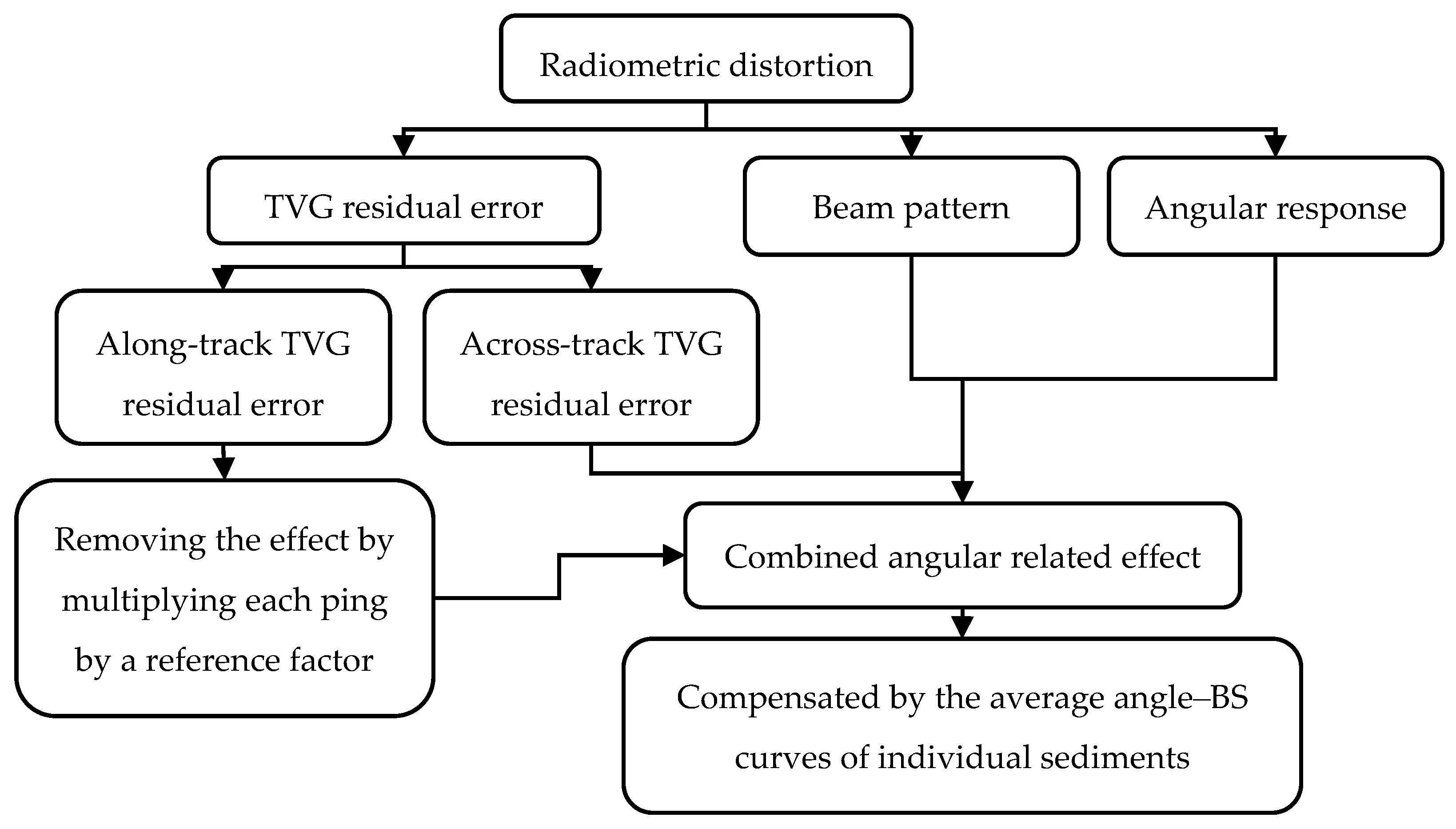
2. Radiometric Distortion
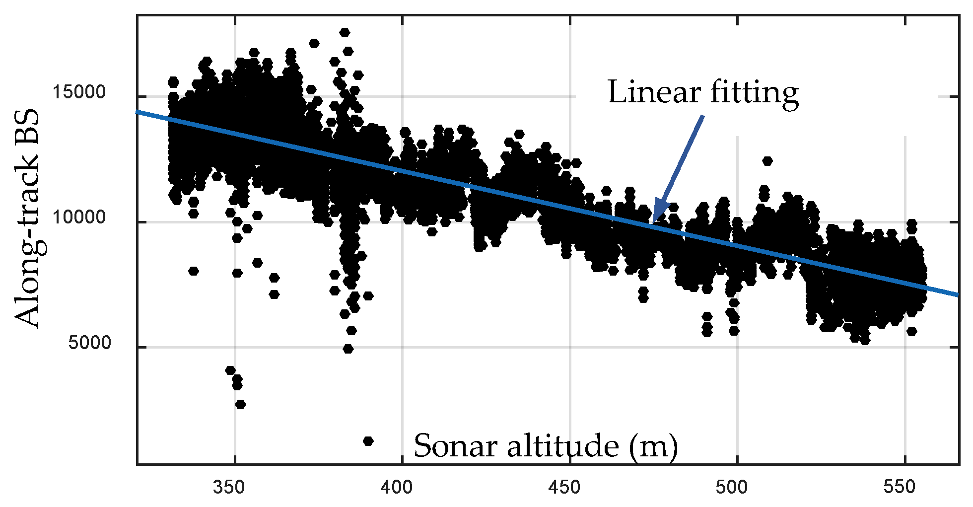
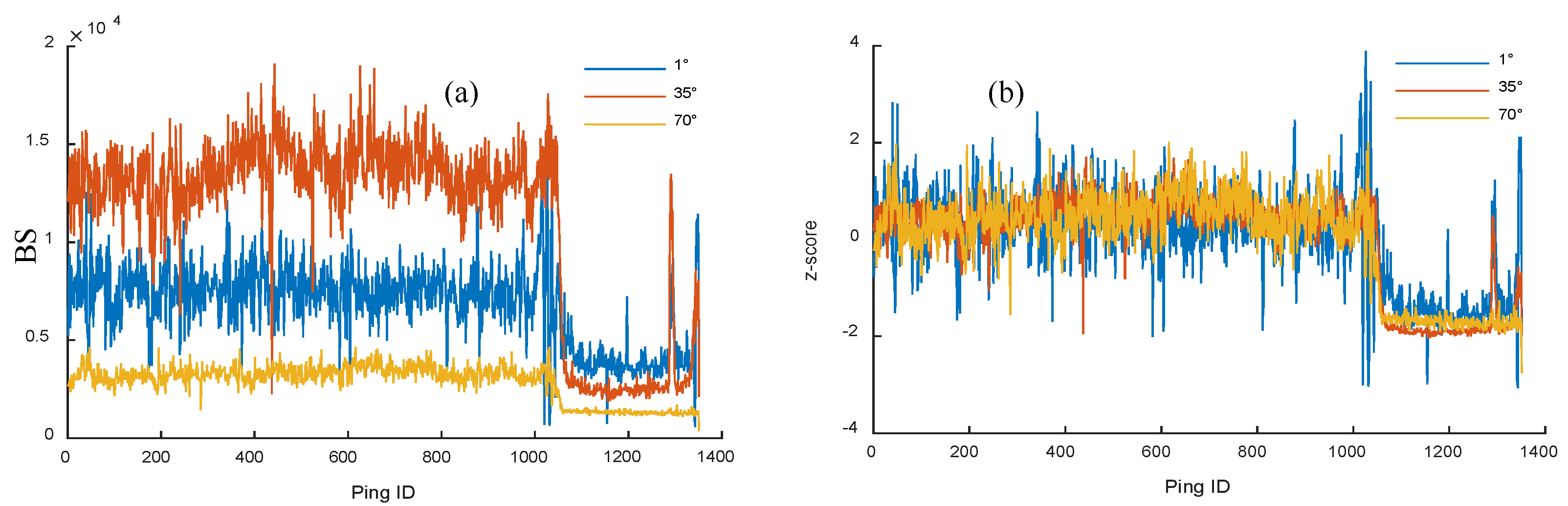
2.1. TVG Residuals
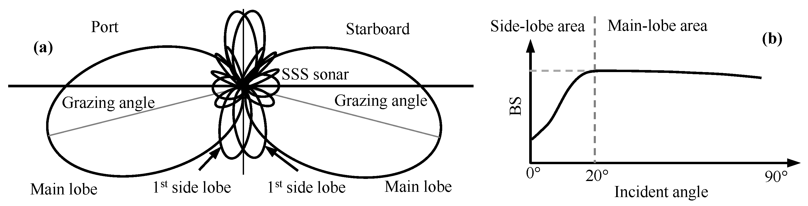
2.2. Beam Patterns
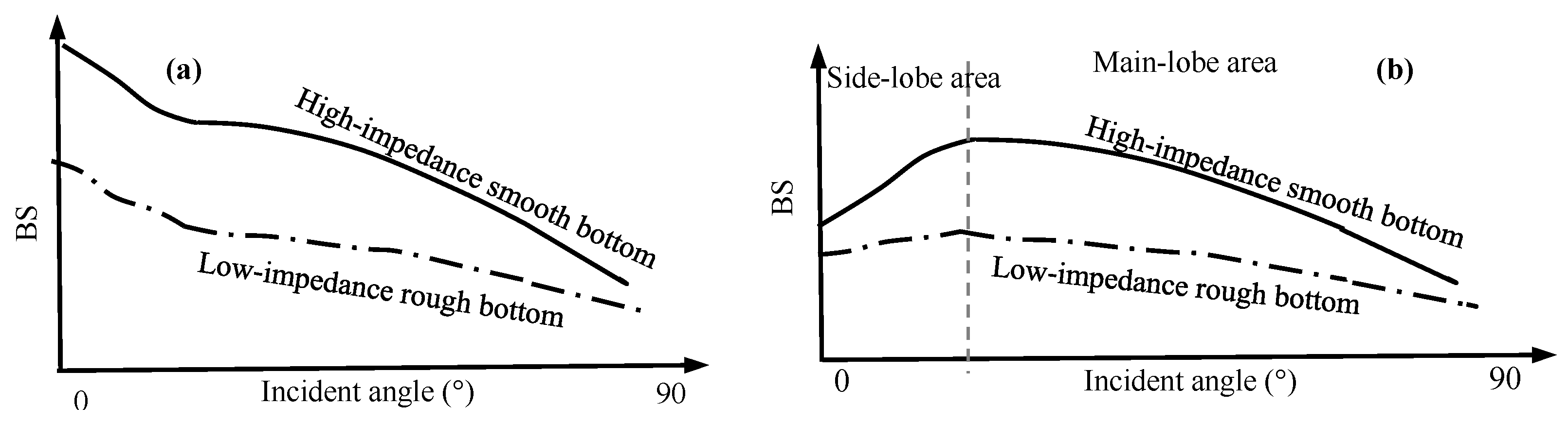
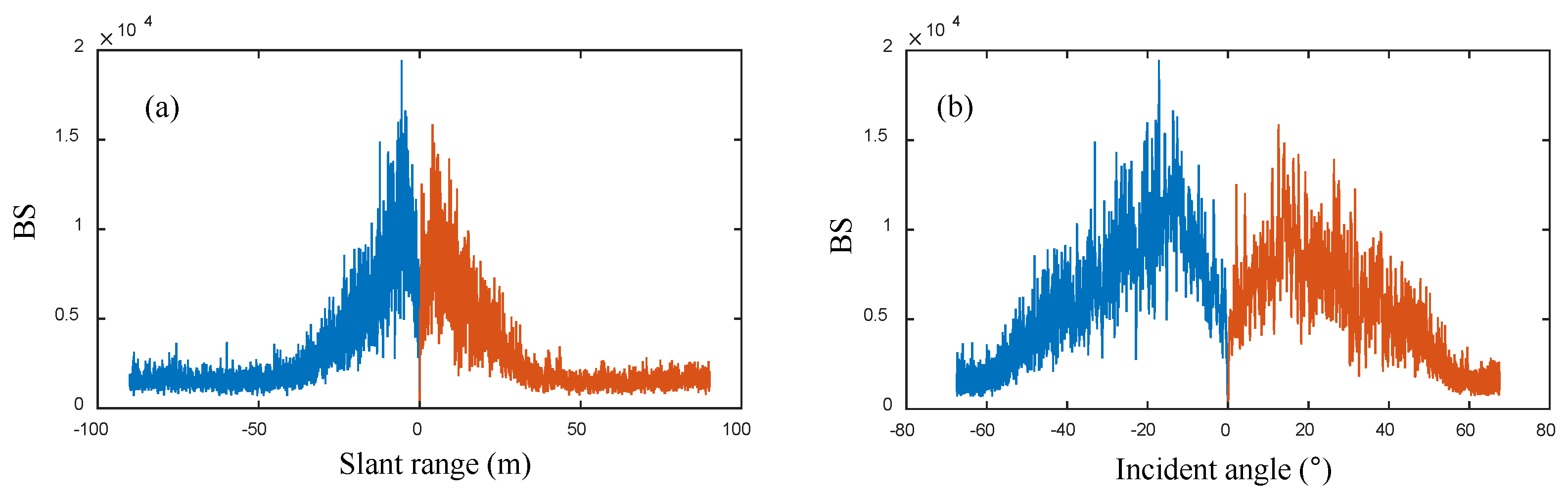
2.3. Angular Response
3. Radiometric Correction
3.1. Correction of Along-Track TVG Residual
3.2. Correction of the Angle-Related Effect
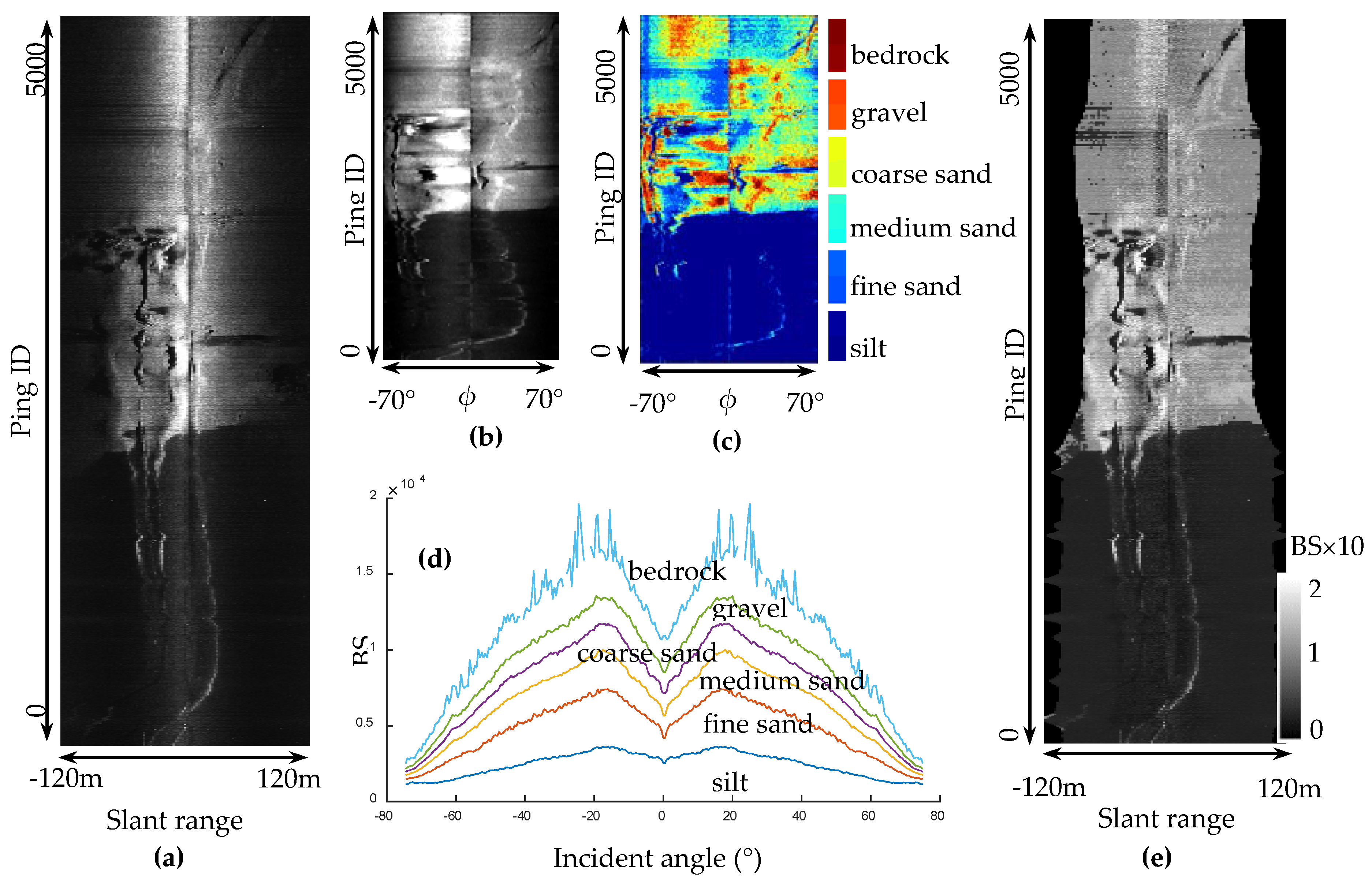
3.2.1. Slant-Range Sequence to Angular Sequence
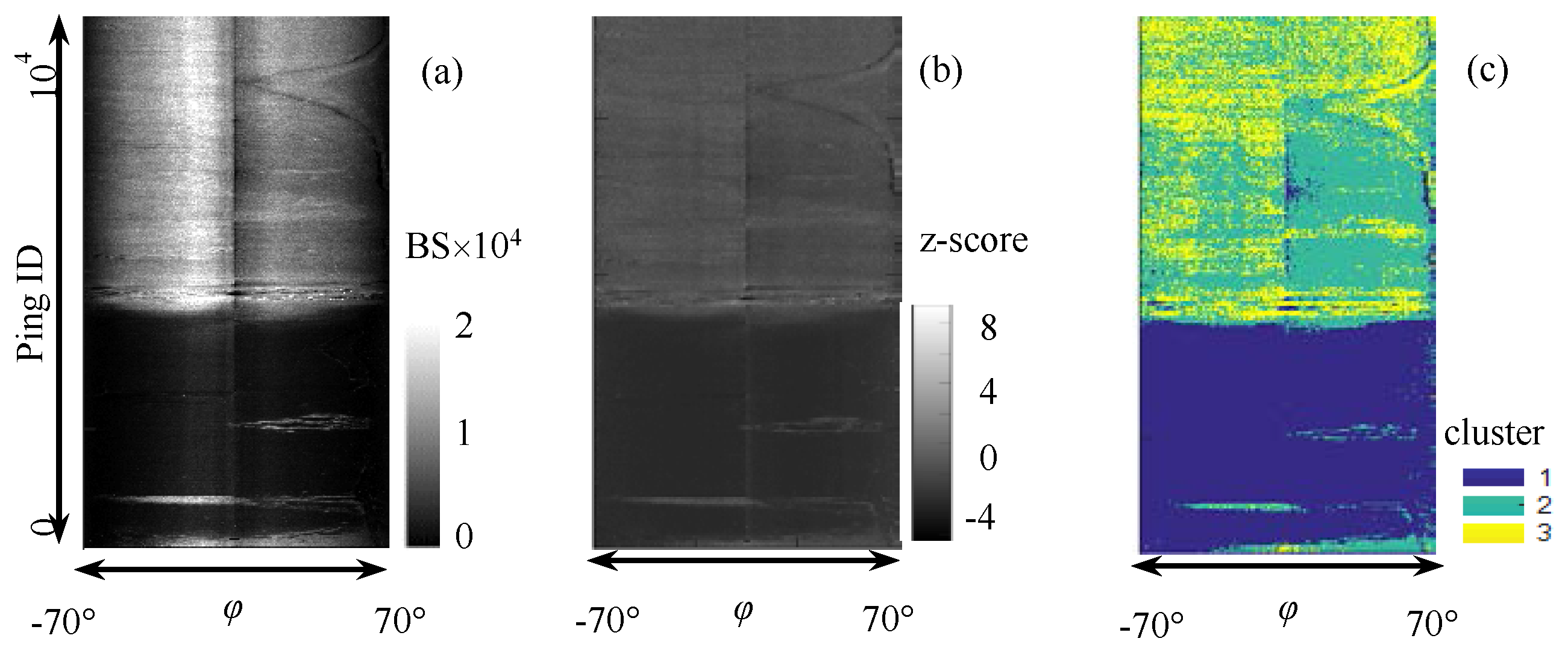
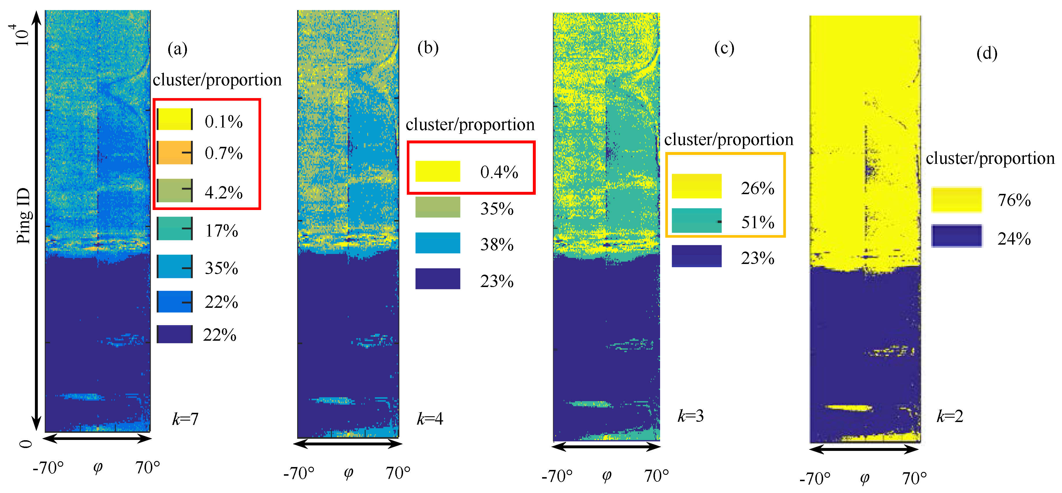
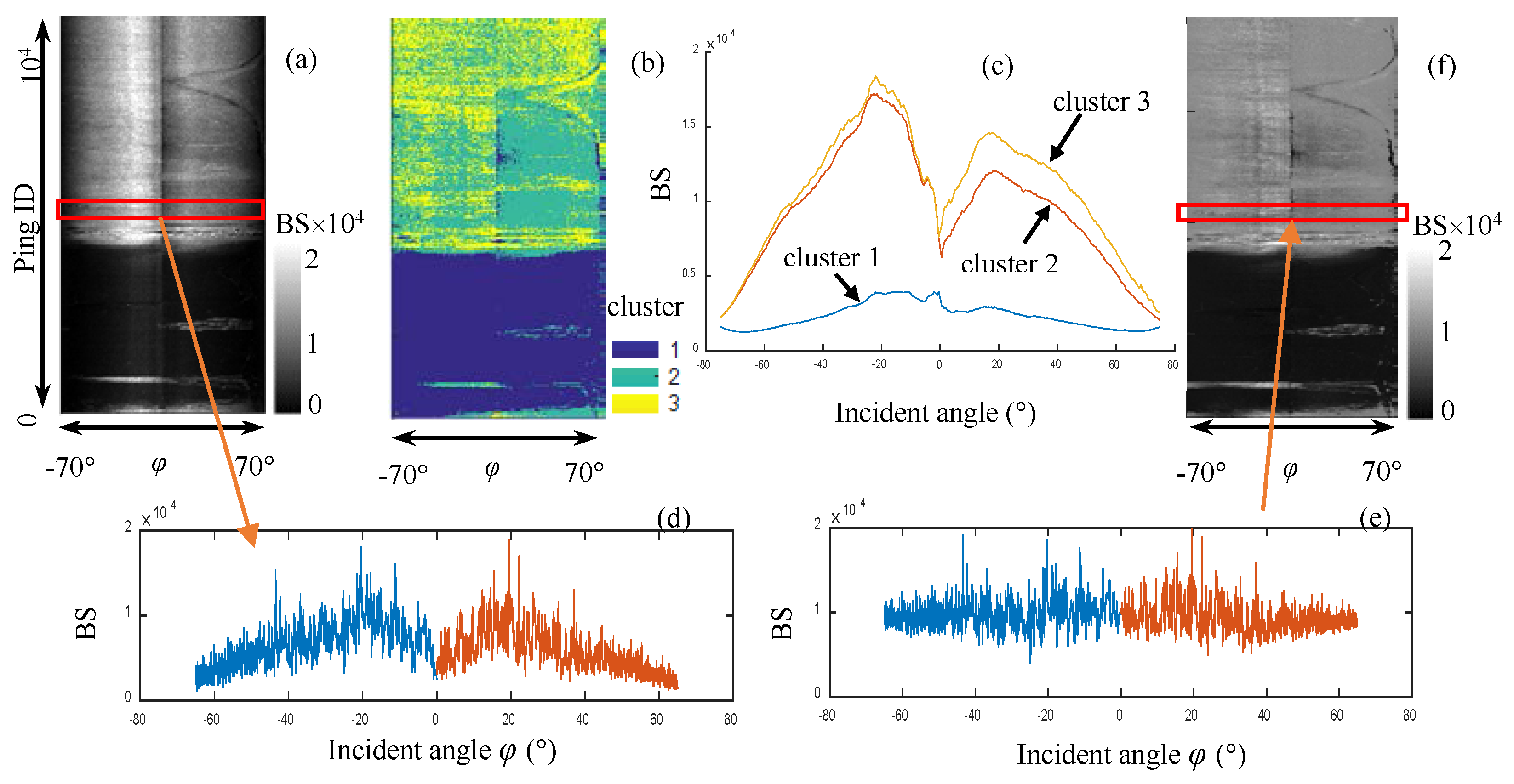
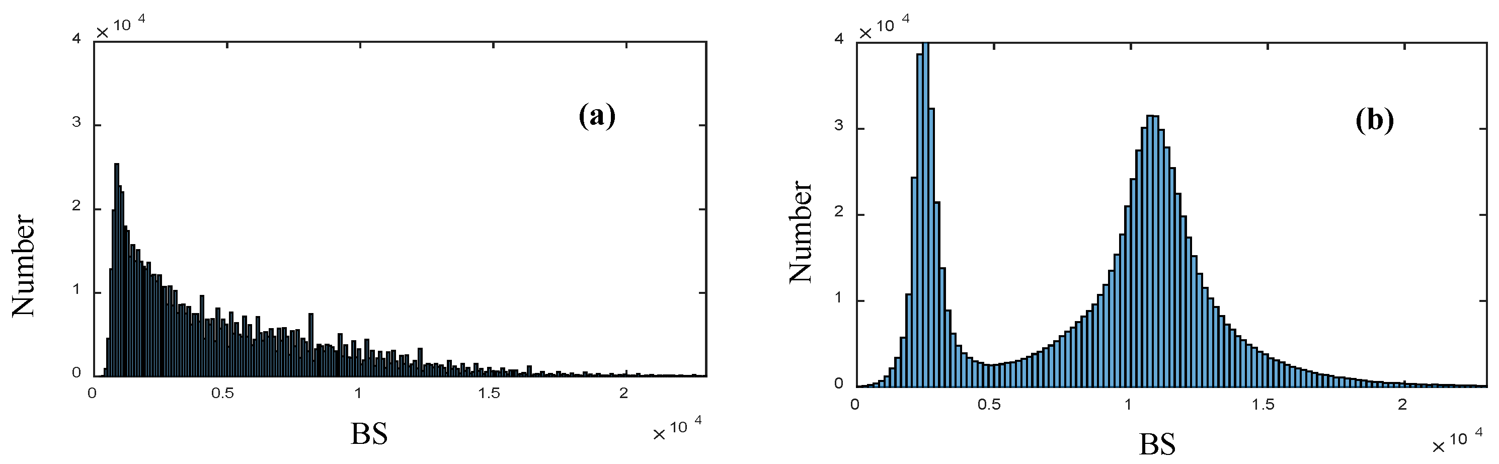
3.2.2. Unsupervised Sediment Classification
- (1)
- Transform two-dimension z-score image Iz to one-dimension vector V.
- (2)
- Use the k-means++ algorithm for the k cluster centers’ initialization of V.
- (3)
- Calculate the distance of each value in V to each centroid, and assign it to the cluster with the closest centroid.
- (4)
- Compute the average values of all the clusters to obtain k new centroid locations.
- (5)
- Repeat Steps 3 and 4 until the cluster assignments do not change and the distribution D of each value in V is obtained.
- (6)
- Transform vector D to two-dimension classification image ID.
- (1)
- Provide a large value (for example, k = 7) as the initial k.
- (2)
- Apply k-means++ on the z-score image with the initial k.
- (3)
- Calculate the center intensities and proportion of each sediment.
- (4)
- Remove the clusters whose proportion is less than 5%, and merge the clusters whose distance is less than 5% of the BS variation range. Then, a new k is obtained.
- (5)
- Repeat Steps 2–4 until k does not change.
3.2.3. Radiometric Correction
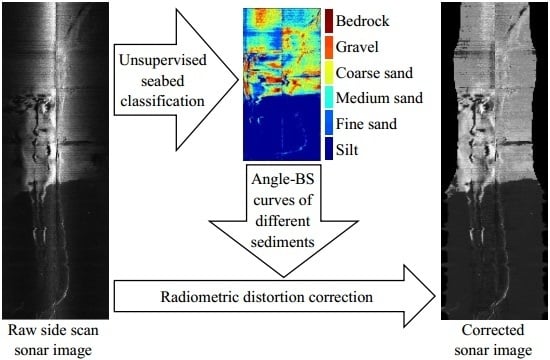
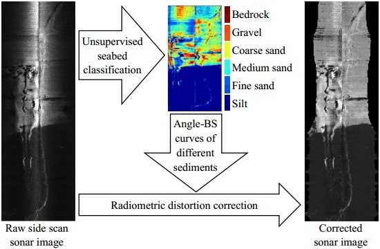
4. Process of Radiometric Distortion Correction for SSS Images
- (1)
- Use bottom line tracking to obtain the along-track sonar altitudes, calculate factor fh with Equation (2) at a given referencing sonar altitude, and remove the along-track TVG residual by multiplying BS with fh.
- (2)
- Transform the slant range to the incident angle and obtain angle–BS sequences.
- (3)
- Use the z-score to normalize the raw BSs and obtain the z-score image.
- (4)
- Apply the unsupervised cluster algorithm and obtain the distributions of different sediments.
- (5)
- Obtain the angle–BS curves of different sediments and implement radiometric correction.
- (6)
- Transform the corrected BS to the gray level and form a new SSS image.
5. Experiments and Analysis
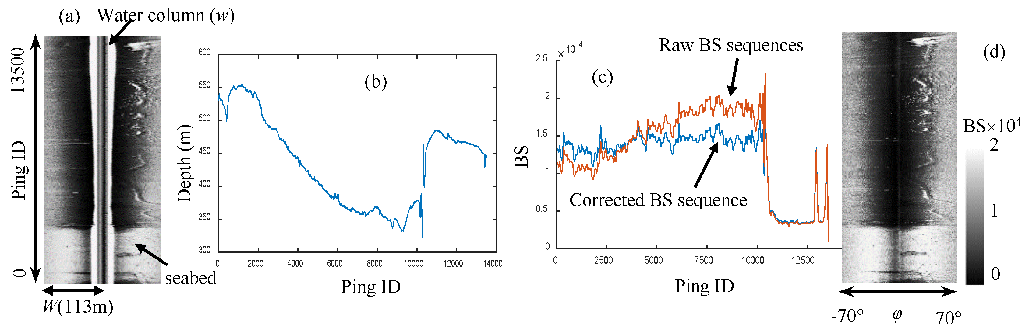
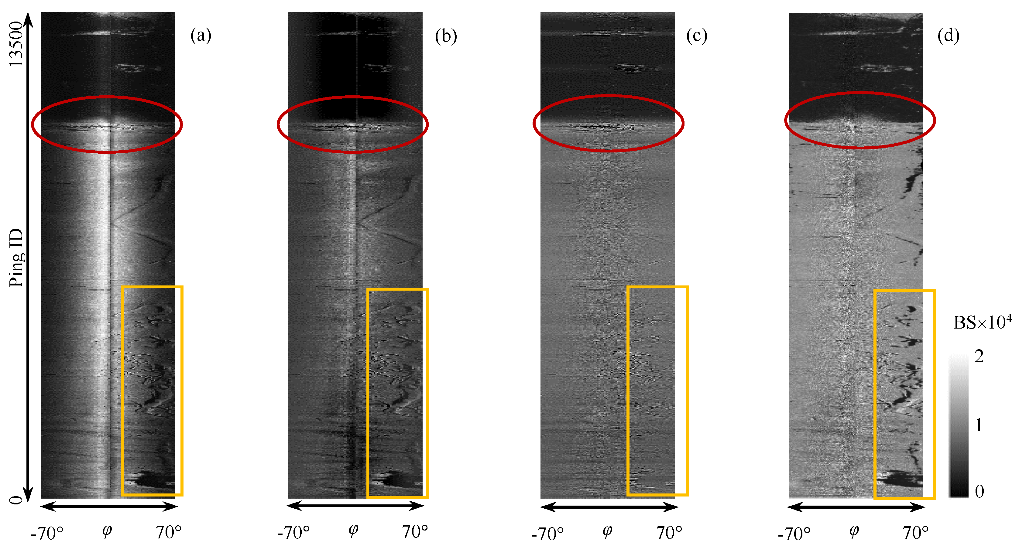
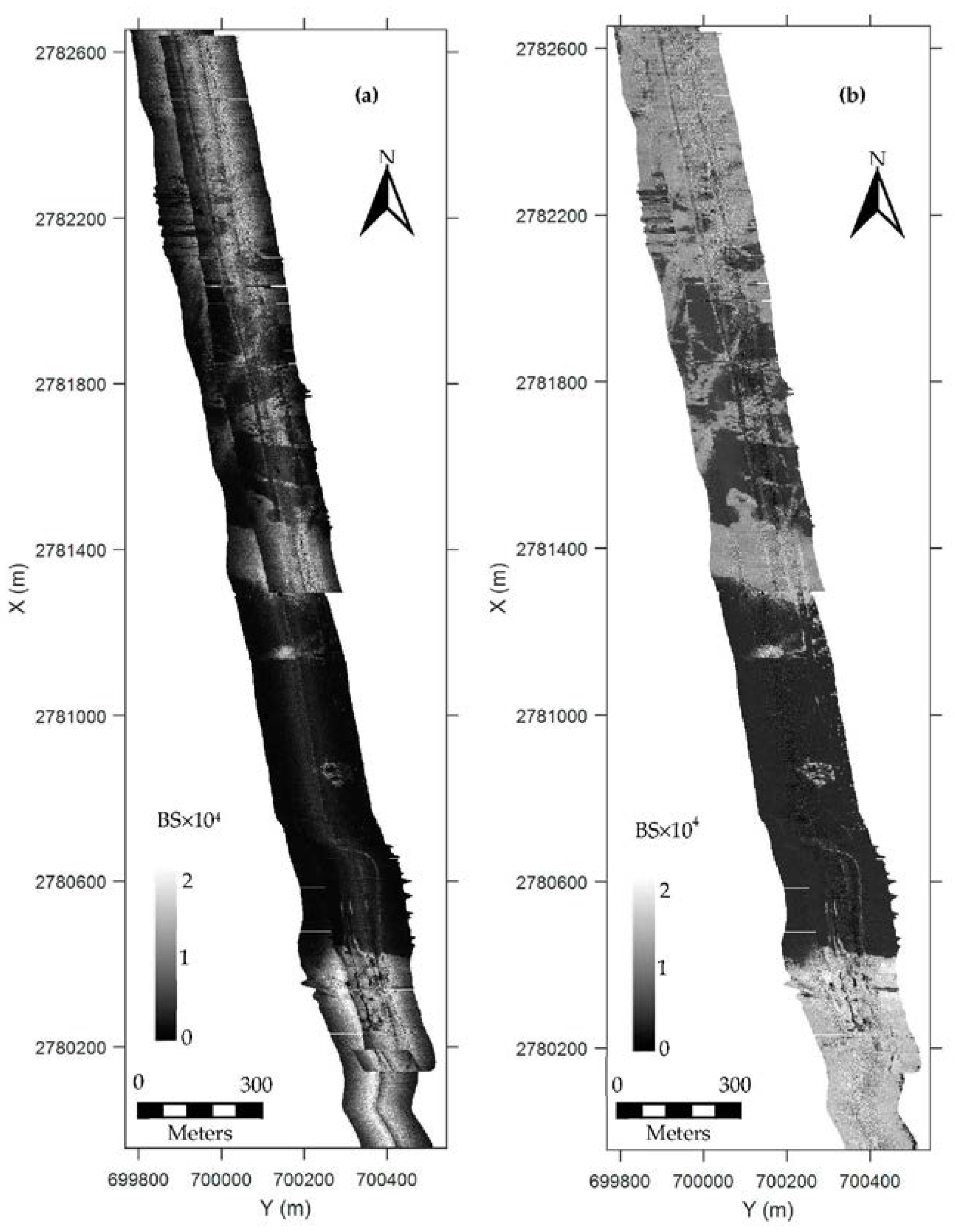
5.1. Correction of Radiometric Distortion
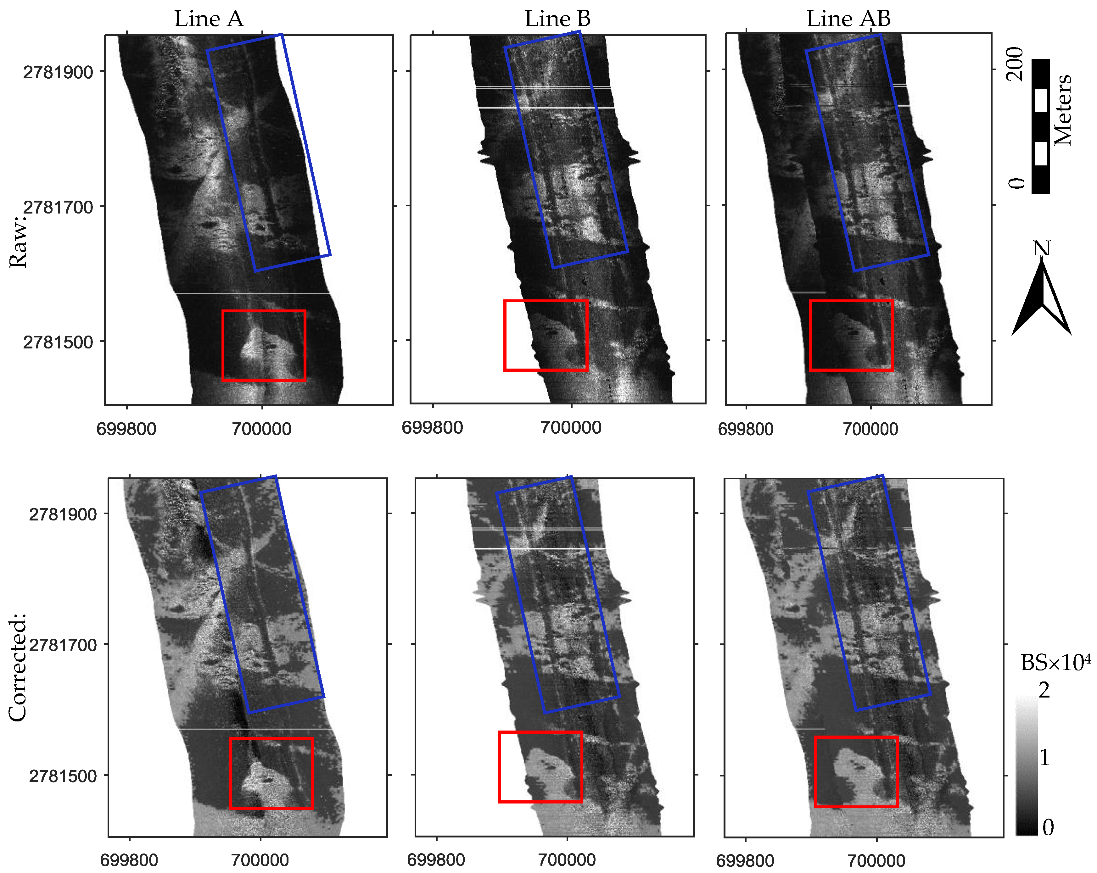
5.2. Consistency Assessment
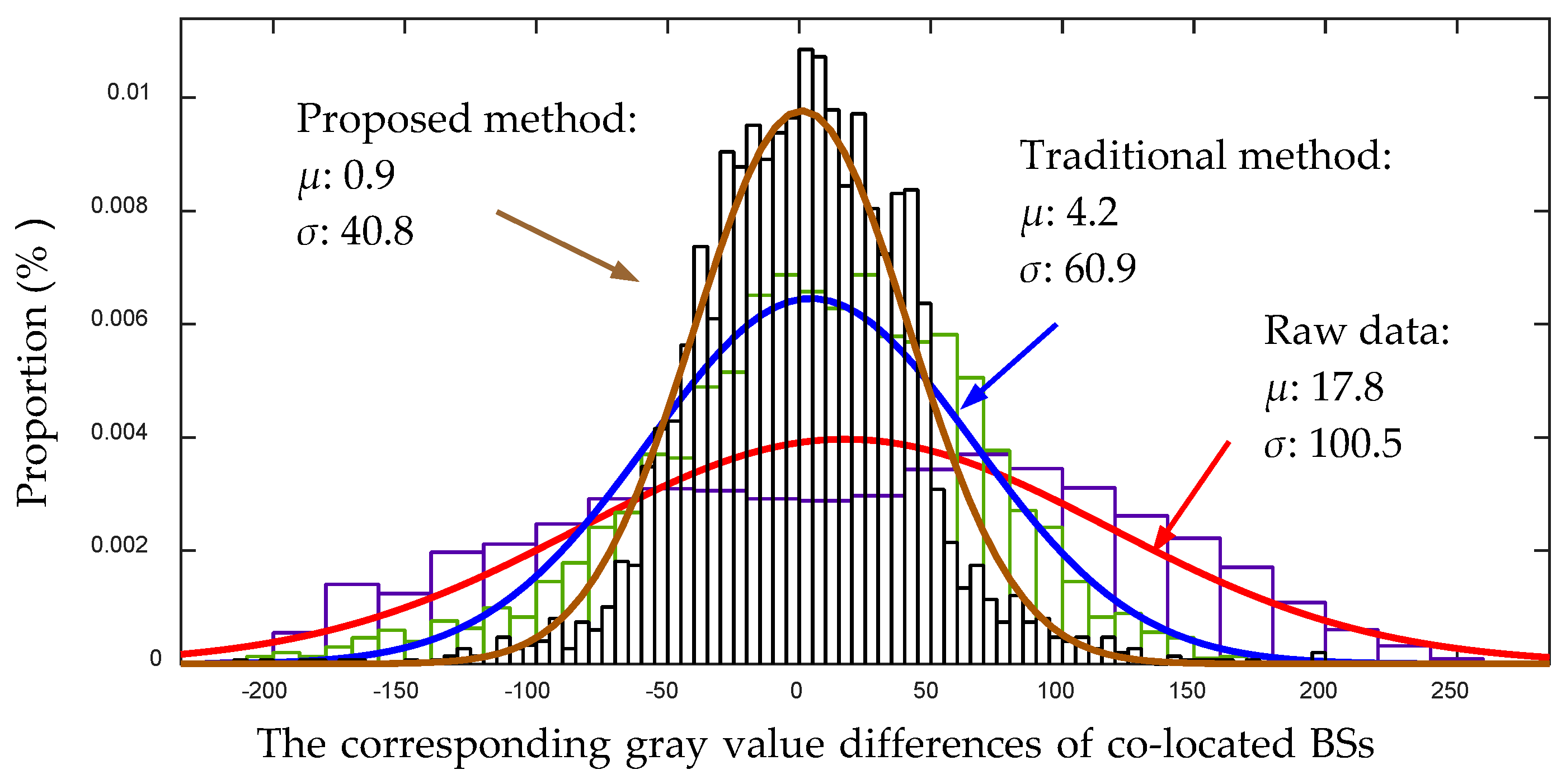
5.2.1. Co-Located Sediment Variation and Target
5.2.2. Co-Located BSs
6. Discussion
6.1. Application of the Proposed Method
6.2. Other Sediment Classification Algorithms
6.3. Other Influential Factors
6.4. Related Work in the Multibeam Sonar Aspect
7. Conclusions
Acknowledgments
Author Contributions
Conflicts of Interest
References
- Kaeser, A.J.; Litts, T.L.; Tracy, T. Using low-cost side-scan sonar for benthic mapping throughout the lower flint river, Georgia, USA. River Res. Appl. 2013, 29, 634–644. [Google Scholar] [CrossRef]
- Powers, J.; Brewer, S.K.; Long, J.M.; Campbell, T. Evaluating the use of side-scan sonar for detecting freshwater mussel beds in turbid river environments. Hydrobiologia 2015, 743, 127–137. [Google Scholar] [CrossRef]
- Haniotis, S.; Cervenka, P.; Negreira, C.; Marchal, J. Seafloor segmentation using angular backscatter responses obtained at sea with a forward-looking sonar system. Appl. Acoust. 2015, 89, 306–319. [Google Scholar] [CrossRef]
- Grządziel, A.; Felski, A.; Wąż, M. Experience with the use of a rigidly-mounted side-scan sonar in a harbour basin bottom investigation. Ocean Eng. 2015, 109, 439–443. [Google Scholar]
- Blondel, P. The Handbook of Sidescan Sonar; Springer Science & Business Media: Berlin, Germany, 2010. [Google Scholar]
- Schultz, J.J.; Healy, C.A.; Parker, K.; Lowers, B. Detecting submerged objects: The application of side scan sonar to forensic contexts. Forensic Sci. Int. 2013, 231, 306–316. [Google Scholar] [CrossRef] [PubMed]
- Buscombe, D. Shallow water benthic imaging and substrate characterization using recreational-grade sidescan-sonar. Environ. Model. Softw. 2017, 89, 1–18. [Google Scholar] [CrossRef]
- Kaeser, A.J.; Litts, T.L. A novel technique for mapping habitat in navigable streams using low-cost side scan sonar. Fisheries 2010, 35, 163–174. [Google Scholar] [CrossRef]
- Capus, C.; Ruiz, I.T.; Petillot, Y. Compensation for changing beam pattern and residual tvg effects with sonar altitude variation for sidescan mosaicing and classification. In Proceedings of the 7th European Conference Underwater Acoustics, Delft, The Netherlands, 5–8 July 2004. [Google Scholar]
- Capus, C.G.; Banks, A.C.; Coiras, E.; Ruiz, I.T.; Smith, C.J.; Petillot, Y.R. Data correction for visualisation and classification of sidescan SONAR imagery. IET Radar Sonar Navig. 2008, 2, 155–169. [Google Scholar] [CrossRef]
- Moreira, M.A.; Vital, H.; Lira, N.B.H.F. Using side scan sonar in the characterization of the continental shelf: Touros area. In Proceedings of the 2013 IEEE/OES, Acoustics in Underwater Geosciences Symposium (RIO Acoustics), Rio de Janeiro, Brazil, 24–26 July 2013; pp. 1–5. [Google Scholar]
- Zhao, J.; Yan, J.; Zhang, H.; Meng, J. Two self-adaptive methods of improving multibeam backscatter image quality by removing angular response effect. J. Mar. Sci. Technol. 2017, 22, 288–300. [Google Scholar] [CrossRef]
- Andersson, A.J.; Reed, T.B.; Winn, C.D. Marine sediment classification using sidescan sonar and geographical information system software in Kaneohe Bay, Oahu, Hawaii. In Proceedings of the Oceans, 2001 MTS/IEEE Conference and Exhibition, Honolulu, HI, USA, 5–8 November 2001; IEEE: Honolulu, HI, USA, 2001; Volume 4, pp. 2653–2657. [Google Scholar]
- Wang, A. Research on 3D Seafloor Terrian Recovery from the Side Scan Sonar Image; Wuhan University: Wuhan, China, 2014. [Google Scholar]
- Hughes Clarke, J.E. Seafloor characterization using keelmounted sidescan: Proper compensation for radiometric and geometric distortion. In Proceedings of the Canadian Hydrographic Conference, Ottawa, ON, Canada, 25–27 May 2004. [Google Scholar]
- Mitchell, N.C.; Somers, M.L. Quantitative backscatter measurements with a long-range side-scan sonar. IEEE J. Ocean. Eng. 1989, 14, 368–374. [Google Scholar] [CrossRef]
- Burguera, A.; Oliver, G. High-Resolution Underwater Mapping Using Side-Scan Sonar. PLoS ONE 2016, 11, e0146396. [Google Scholar] [CrossRef] [PubMed]
- Waite, A.D. Sonar for Practising Engineers, 3rd ed.; John Wiley & Sons Incorporated: Chichester, UK, 2002. [Google Scholar]
- Chang, Y.-C.; Hsu, S.-K.; Tsai, C.-H. Sidescan sonar image processing: Correcting brightness variation and patching gaps. J. Mar. Sci. Technol. 2010, 18, 785–789. [Google Scholar]
- Mazel, C. Side Scan Sonar Record Interpretation; Klein and Associates, Inc.: Salem, NH, USA, 1985. [Google Scholar]
- Zhao, J.; Wang, X.; Zhang, H.; Wang, A. A Comprehensive Bottom-Tracking Method for Sidescan Sonar Image Influenced by Complicated Measuring Environment. IEEE J. Ocean. Eng. 2016. [Google Scholar] [CrossRef]
- Honsho, C.; Ura, T.; Asada, A.; Kim, K.; Nagahashi, K. High-resolution acoustic mapping to understand the ore deposit in the Bayonnaise knoll caldera, Izu-Ogasawara arc. J. Geophys. Res. Solid Earth 2015, 120, 2070–2092. [Google Scholar] [CrossRef]
- Fonseca, L.; Calder, B. Clustering acoustic backscatter in the angular response space. In Proceedings of the US Hydrographic Conference, Norfolk, VA, USA, 14–18 May 2007. [Google Scholar]
- Arthur, D.; Vassilvitskii, S. K-means++: The advantages of careful seeding. In Proceedings of the Advances in the Eighteenth Annual ACM-SIAM Symposium on Discrete Algorithms, New Orleans, LA, USA, 7–9 January 2007; Society for Industrial and Applied Mathematics: Philadelphia, PA, USA; pp. 1027–1035. [Google Scholar]
- Buscombe, D.; Grams, P.E.; Smith, S.M.C. Automated Riverbed Sediment Classification Using Low-Cost Sidescan Sonar. J. Hydraul. Eng. 2016, 142. [Google Scholar] [CrossRef]
- Goff, J.A.; Olson, H.C.; Duncan, C.S. Correlation of side-scan backscatter intensity with grain-size distribution of shelf sediments, New Jersey margin. Geo-Mar. Lett. 2000, 20, 43–49. [Google Scholar] [CrossRef]
- Collier, J.; Brown, C. Correlation of sidescan backscatter with grain size distribution of surficial seabed sediments. Mar. Geol. 2005, 214, 431–449. [Google Scholar] [CrossRef]
- Atallah, L.; Probert Smith, P.J.; Bates, C.R. Wavelet analysis of bathymetric sidescan sonar data for the classification of seafloor sediments in Hopvågen Bay-Norway. Mar. Geophys Res. 2002, 23, 431–442. [Google Scholar] [CrossRef]
- De Moustier, C.; Alexandrou, D. Angular dependence of 12-kHz seafloor acoustic backscatter. J. Acoust. Soc. Am. 1991, 90, 522–531. [Google Scholar] [CrossRef]
- Fernandes, W.; Chakraborty, B. Multi-beam backscatter image data processing techniques employed to EM 1002 system. In Proceedings of the 2009 International Symposium on Ocean Electronics (SYMPOL 2009), Cochin, India, 18–20 November 2009; pp. 93–99. [Google Scholar]
- Chakraborty, B.; Menezes, A.; Dandapath, S.; Fernandes, W.A.; Karisiddaiah, S.M.; Haris, K.; Gokul, G.S. Application of Hybrid Techniques (Self-Organizing Map and Fuzzy Algorithm) Using Backscatter Data for Segmentation and Fine-Scale Roughness Characterization of Seepage-Related Seafloor Along the Western Continental Margin of India. IEEE J. Ocean. Eng. 2015, 40, 3–14. [Google Scholar] [CrossRef]
- Schimel, A.C.; Rzhanov, Y.; Fonseca, L.; Mayer, M.; Immenga, D. Combining angular and spatial information from multibeam backscatter data for improved unsupervised acoustic seabed segmentation. In Proceedings of the Marine Geological and Biological Habitat Mapping 2013, Rome, Italy, 6–10 May 2013. [Google Scholar]
- De Moustier, C.; Matsumoto, H. Seafloor acoustic remote sensing with multibeam echo-sounders and bathymetric sidescan sonar systems. Mar. Geophys. Res. 1993, 15, 27–42. [Google Scholar] [CrossRef]
- Cutter, G.R.; Rzhanov, Y.; Mayer, L.A. Automated segmentation of seafloor bathymetry from multibeam echosounder data using local Fourier histogram texture features. J. Exp. Mar. Biol. Ecol. 2003, 285, 355–370. [Google Scholar] [CrossRef]


© 2017 by the authors. Licensee MDPI, Basel, Switzerland. This article is an open access article distributed under the terms and conditions of the Creative Commons Attribution (CC BY) license (http://creativecommons.org/licenses/by/4.0/).
Share and Cite
Zhao, J.; Yan, J.; Zhang, H.; Meng, J. A New Radiometric Correction Method for Side-Scan Sonar Images in Consideration of Seabed Sediment Variation. Remote Sens. 2017, 9, 575. https://doi.org/10.3390/rs9060575
Zhao J, Yan J, Zhang H, Meng J. A New Radiometric Correction Method for Side-Scan Sonar Images in Consideration of Seabed Sediment Variation. Remote Sensing. 2017; 9(6):575. https://doi.org/10.3390/rs9060575
Chicago/Turabian StyleZhao, Jianhu, Jun Yan, Hongmei Zhang, and Junxia Meng. 2017. "A New Radiometric Correction Method for Side-Scan Sonar Images in Consideration of Seabed Sediment Variation" Remote Sensing 9, no. 6: 575. https://doi.org/10.3390/rs9060575