
Building Damage Assessment Using Multisensor Dual-Polarized Synthetic Aperture Radar Data for the 2016 M 6.2 Amatrice Earthquake, Italy


Abstract
:
1. Introduction
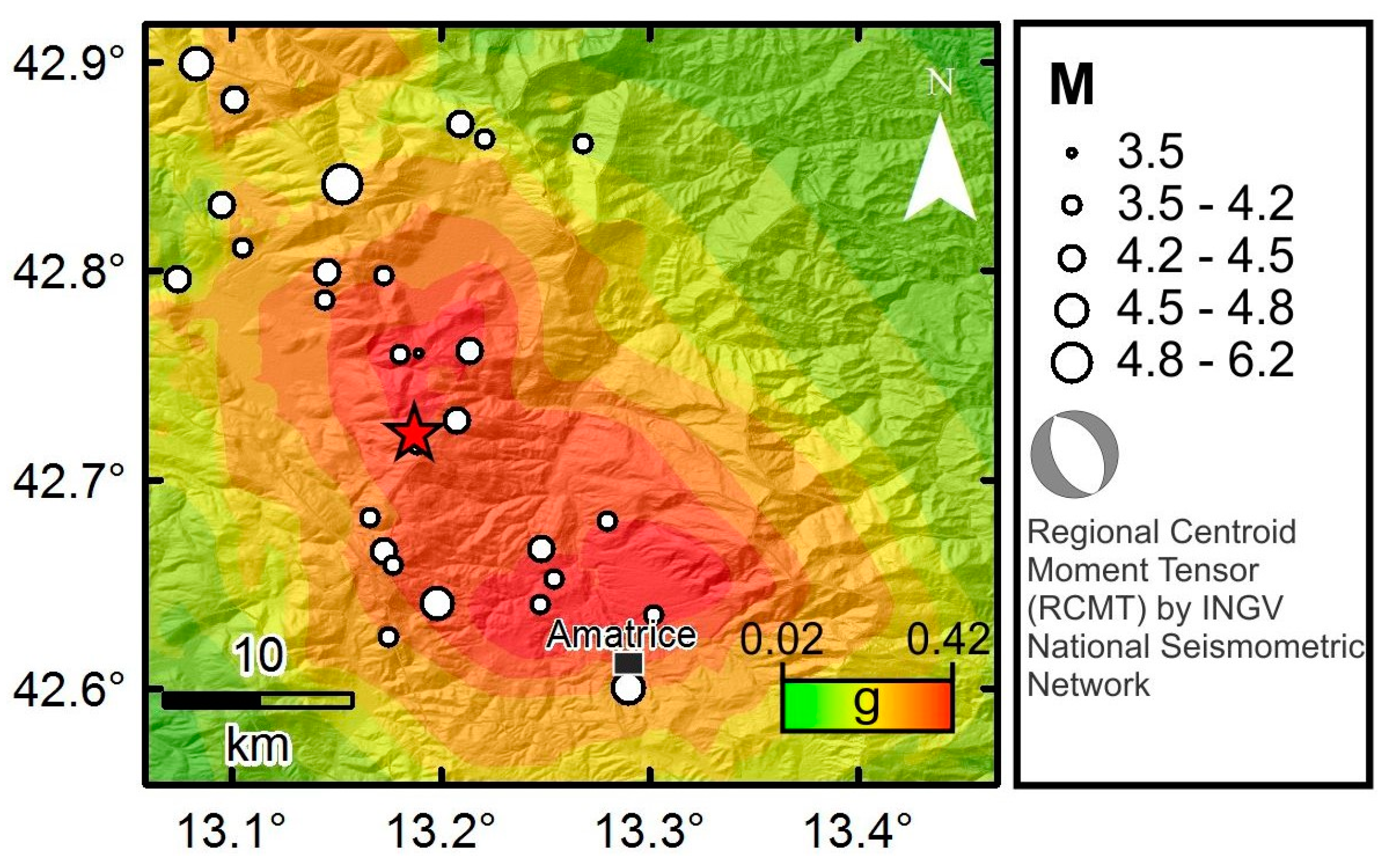
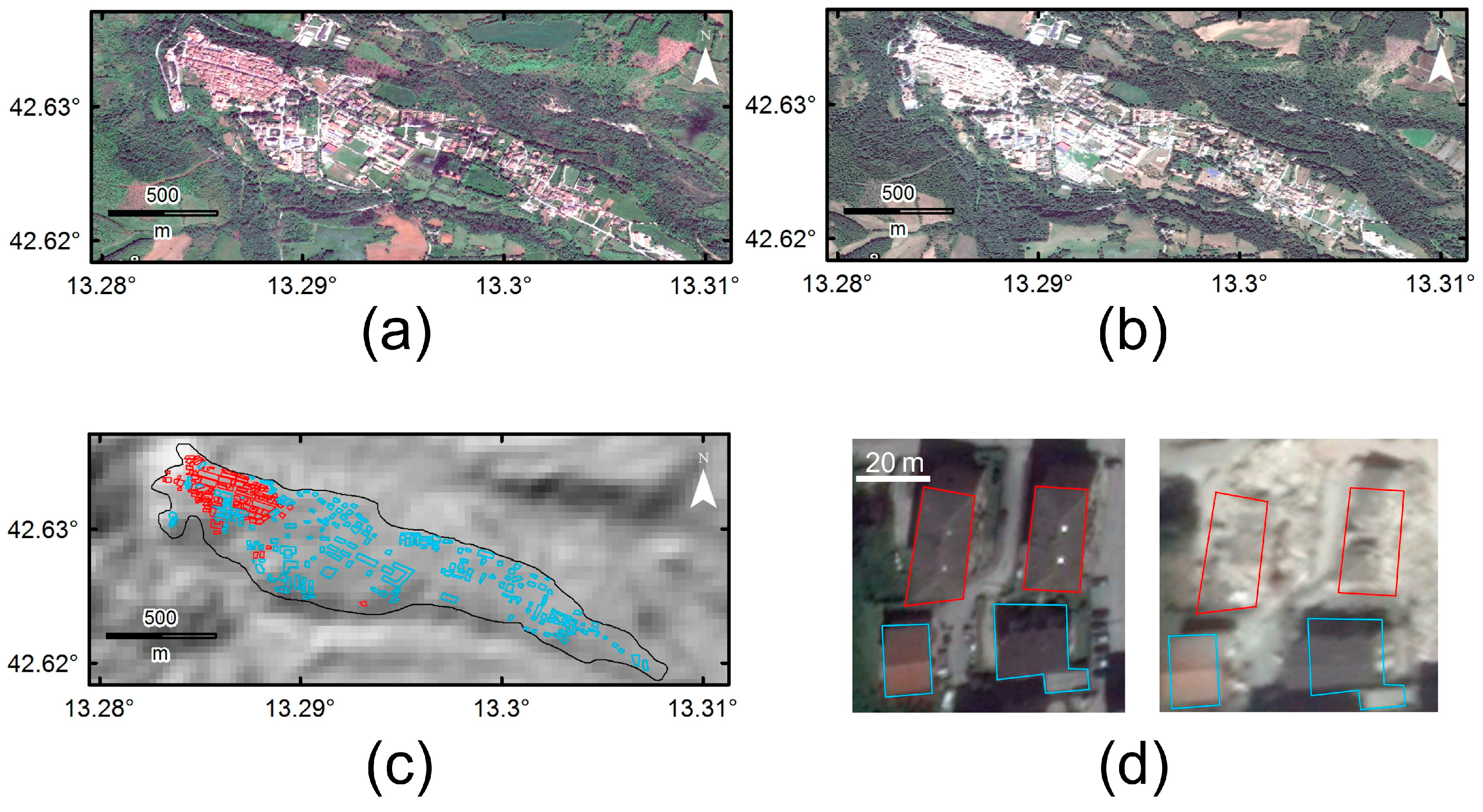
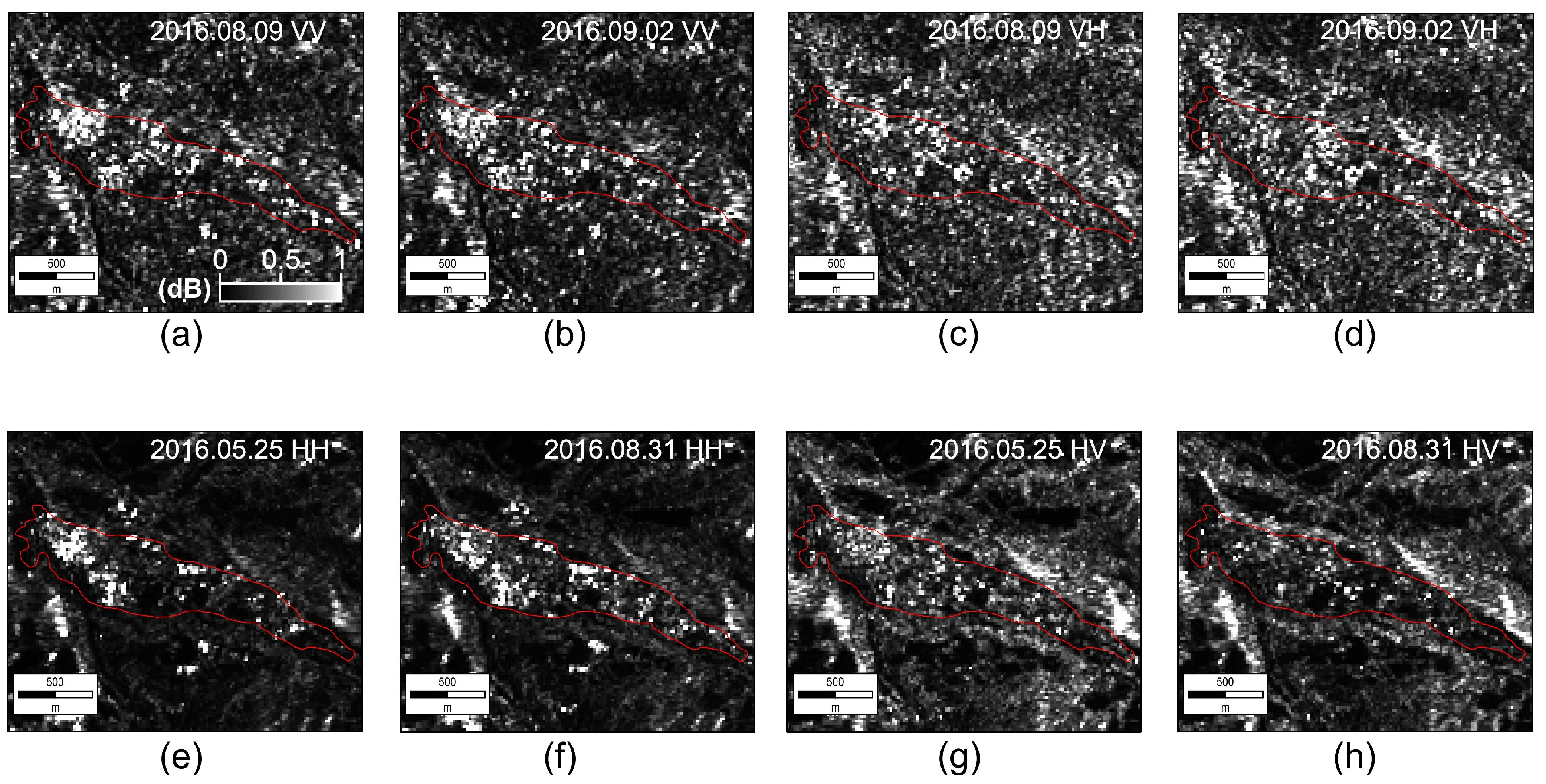
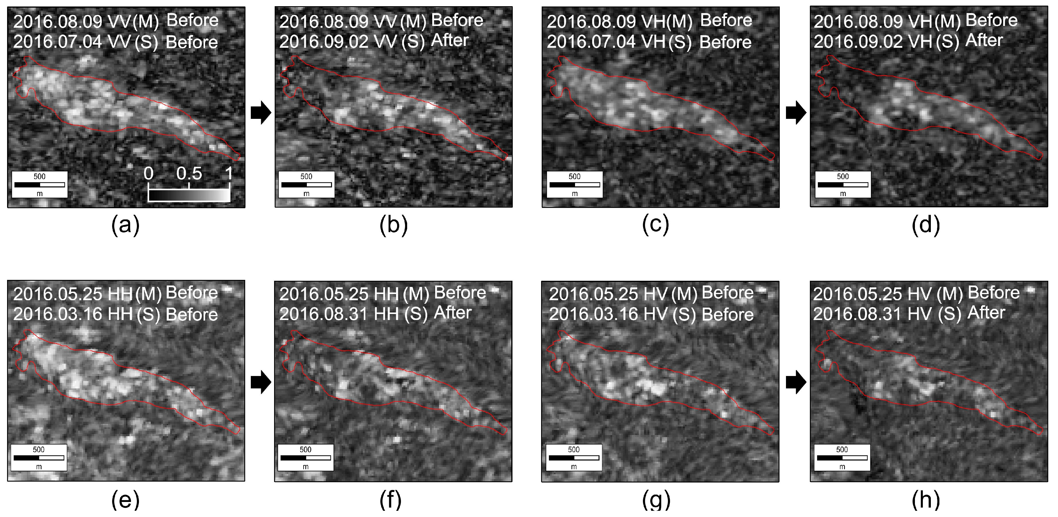
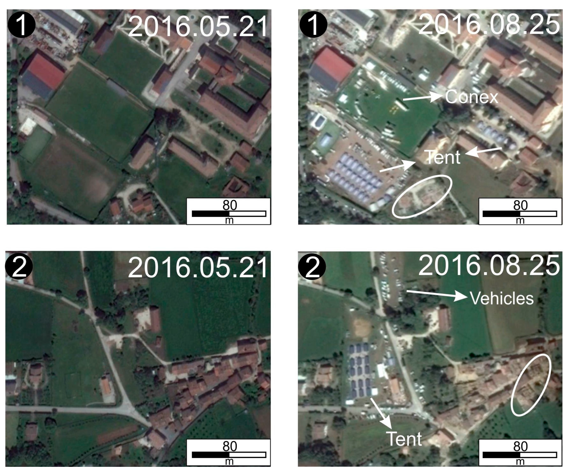
2. Study Area and SAR Data
3. Methodology
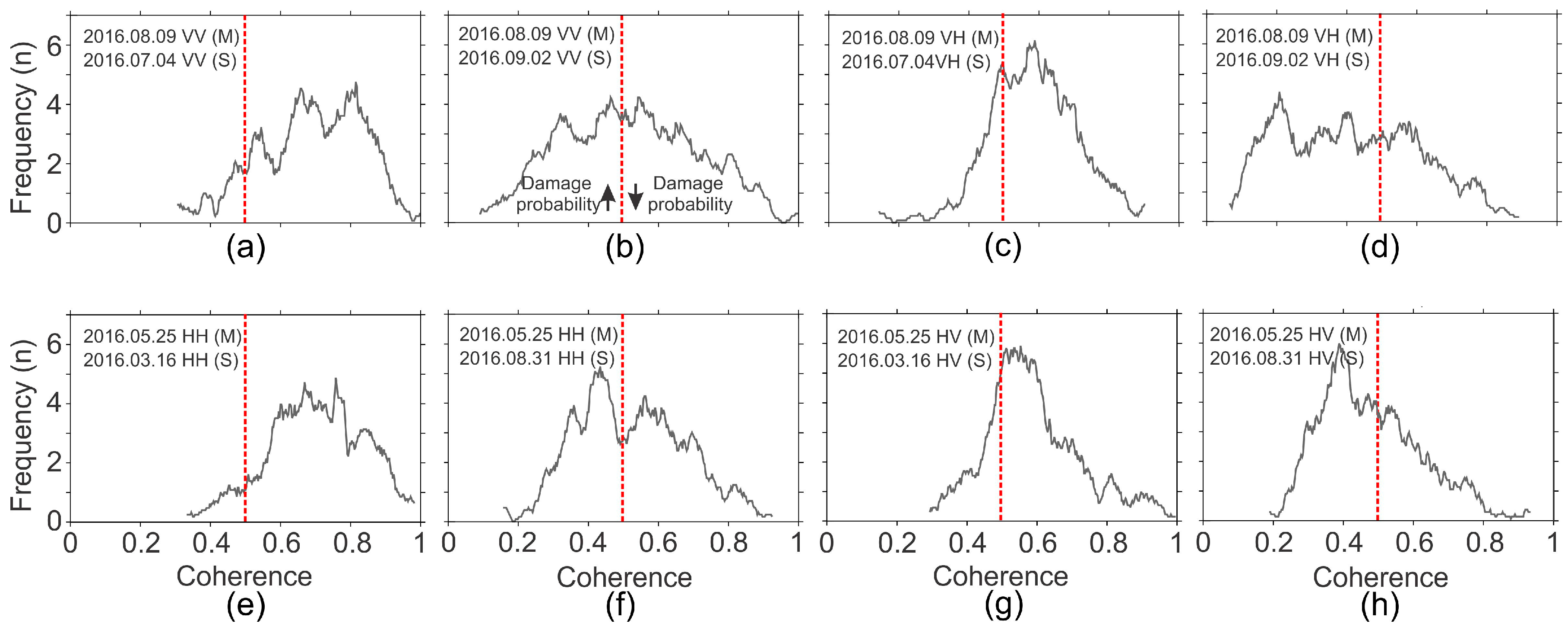
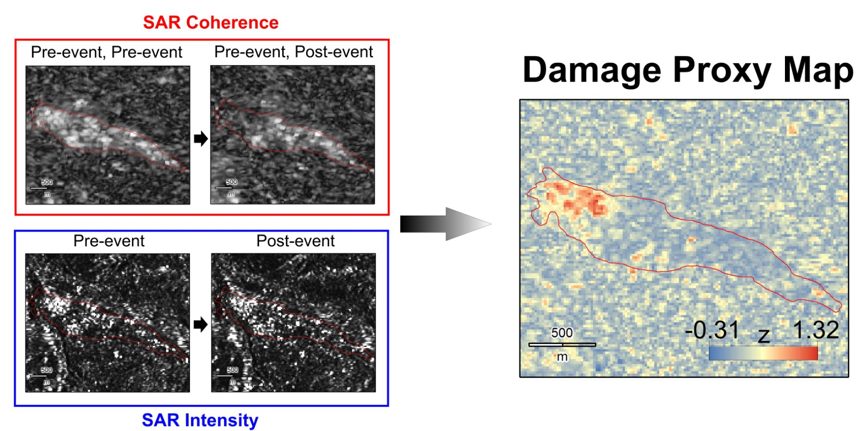
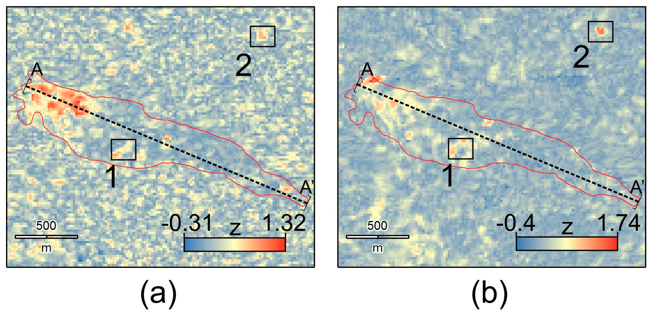
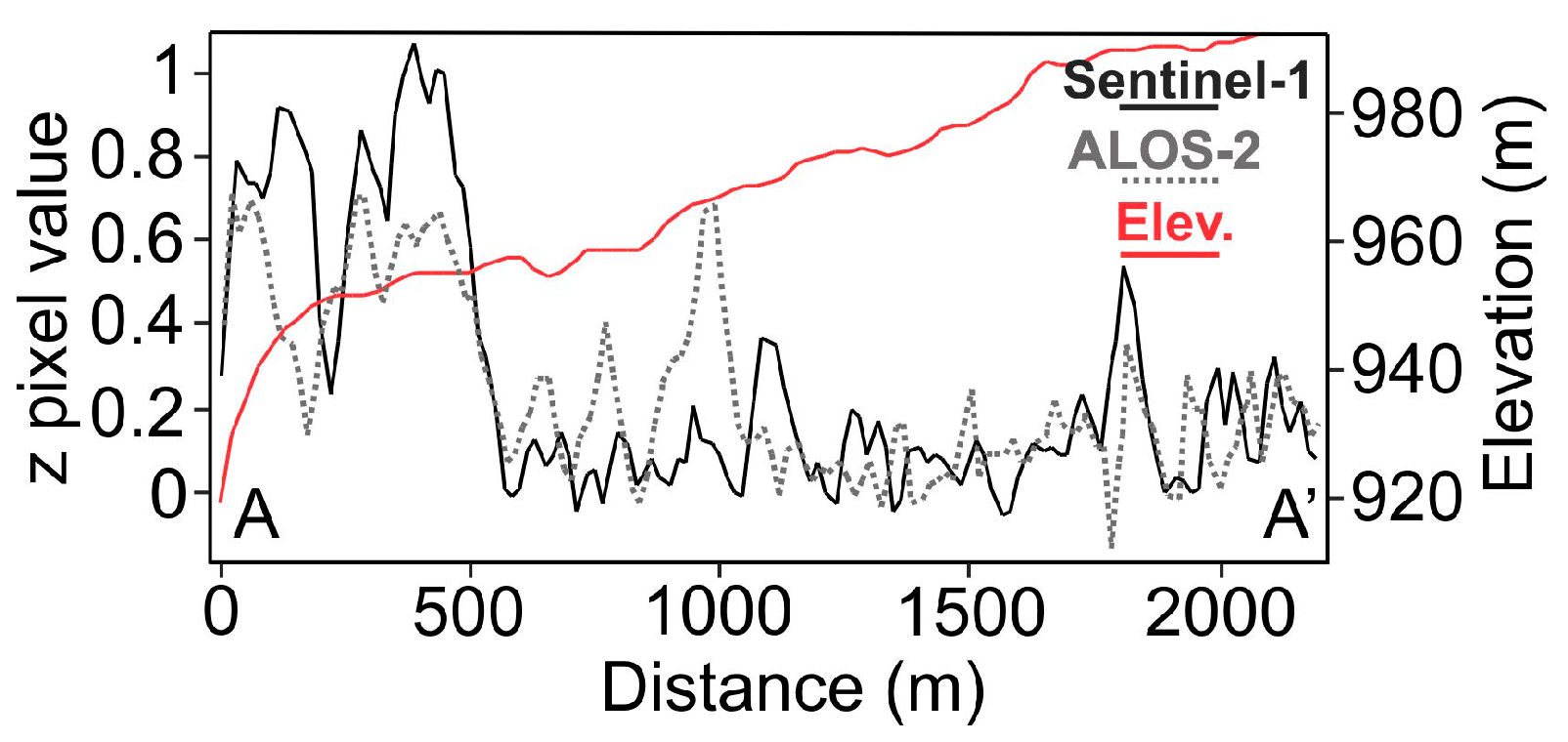
3.1. SAR Intensity and SAR Coherence
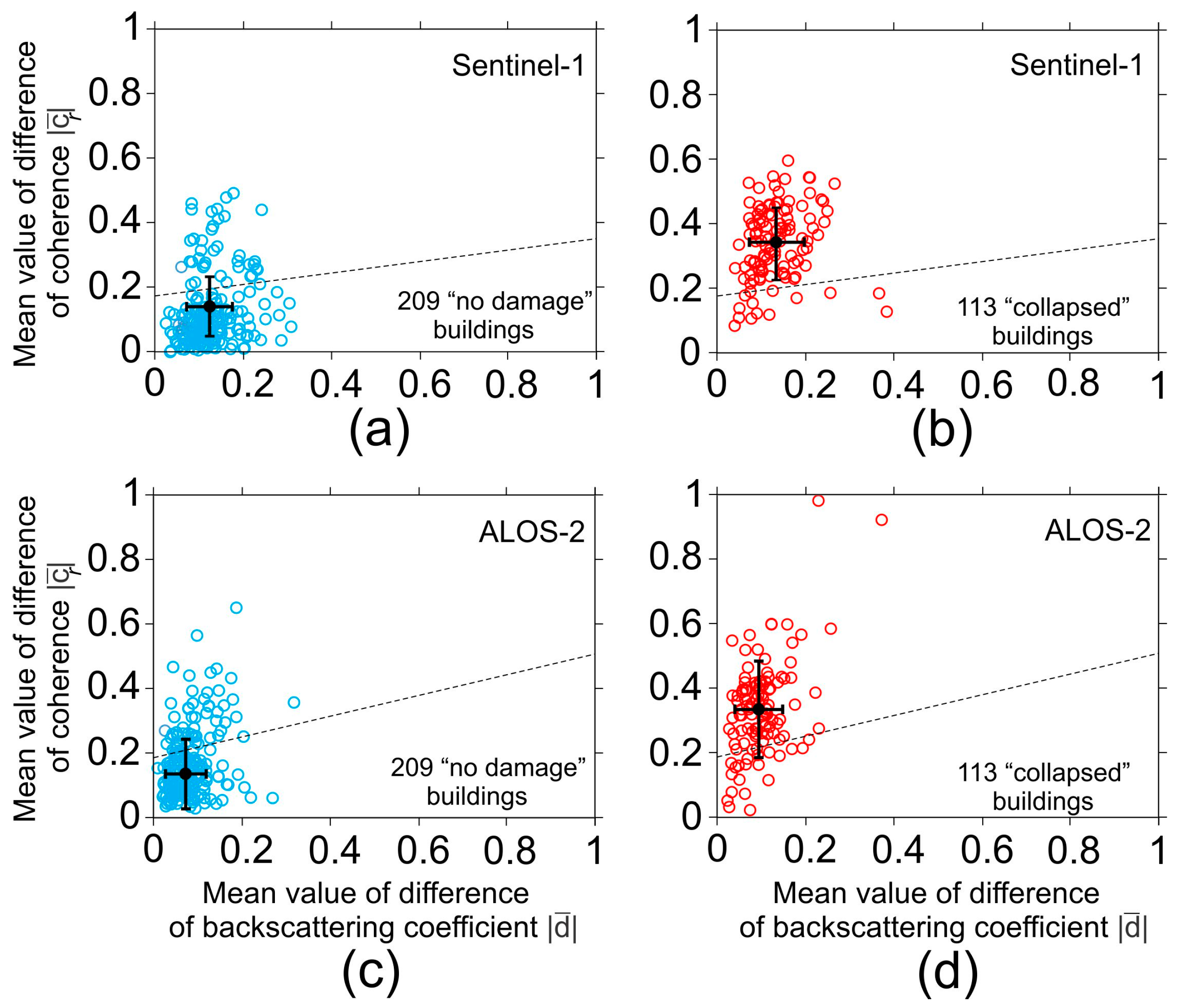
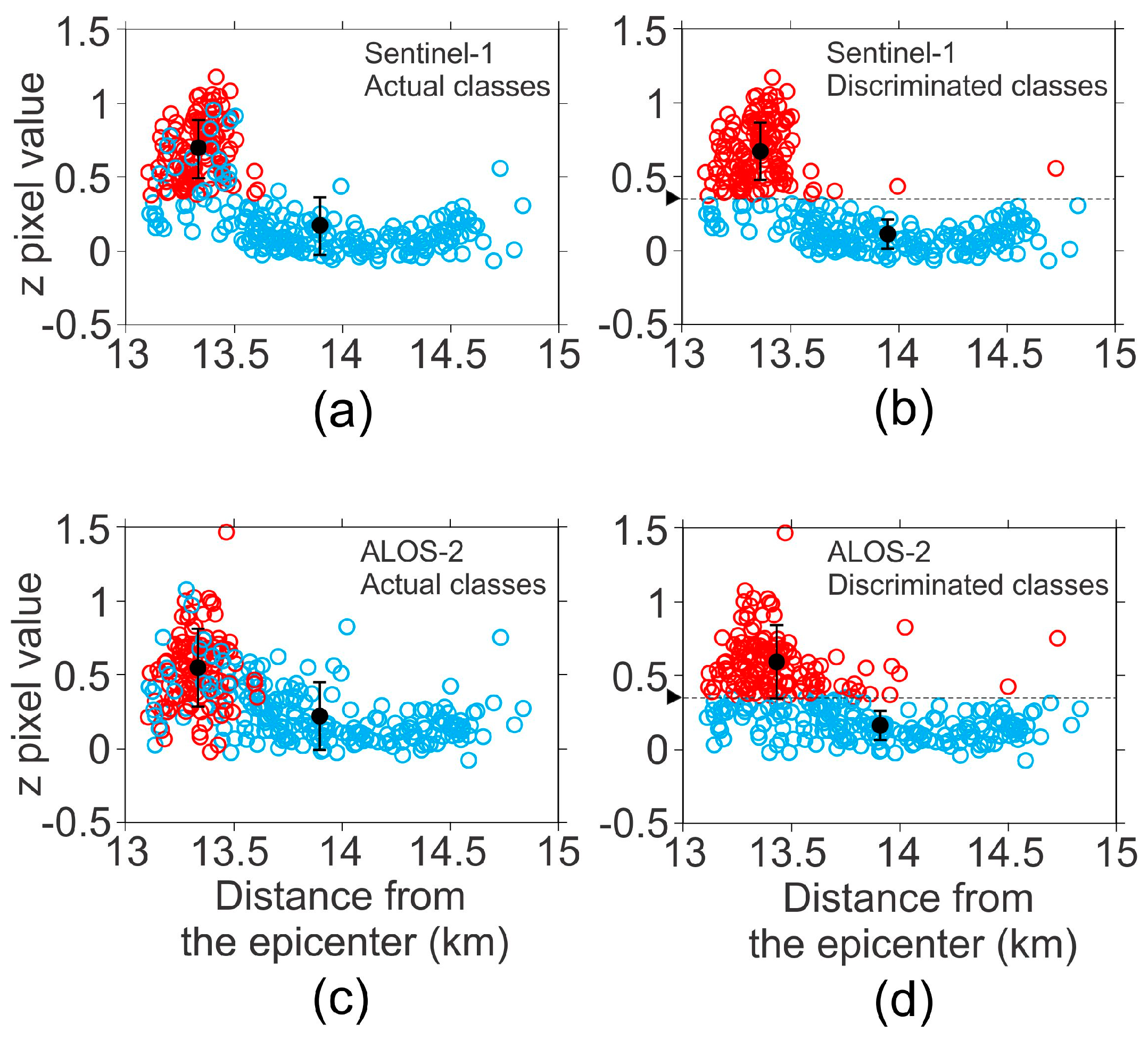
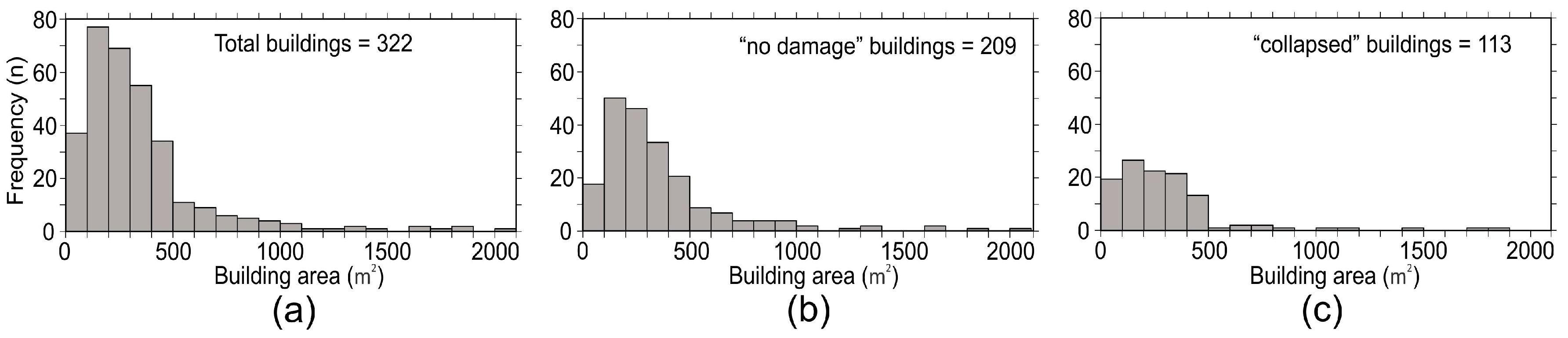
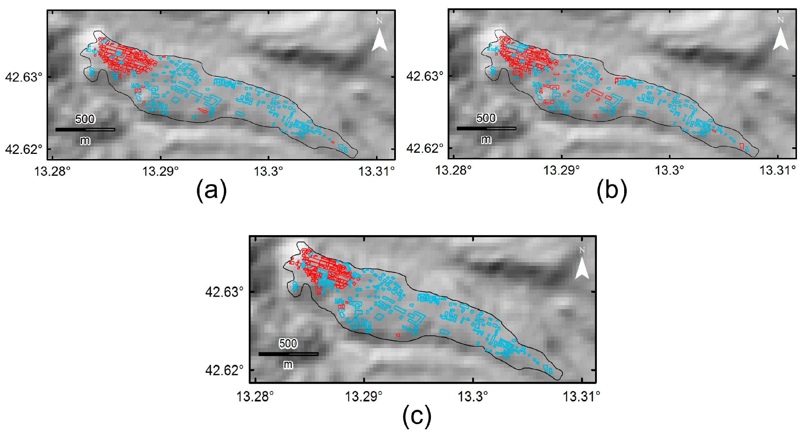
3.2. Discriminant Analysis and Damage Proxy Maps
4. Discussion
5. Summary and Conclusions
Acknowledgments
Author Contributions
Conflicts of Interest
References
- Karimzadeh, S.; Miyajima, M.; Hassanzadeh, R.; Amiraslanzadeh, R.; Kamel, B. A GIS-based seismic hazard, building vulnerability and human loss assessment for the earthquake scenario in Tabriz. Soil Dyn. Earthq. Eng. 2014, 66, 263–280. [Google Scholar] [CrossRef]
- Karimzadeh, S.; Feizizadeh, B.; Matsuoka, M. From a GIS-based hybrid site condition map to an earthquake damage assessment in Iran: Methods and trends. Int. J. Disaster Risk Reduct. 2017, 22, 23–36. [Google Scholar] [CrossRef]
- Karimzadeh, S. Characterization of land subsidence in Tabriz basin (NW Iran) using InSAR and watershed analyses. Acta Geod. Geophys. 2016, 51, 181–195. [Google Scholar] [CrossRef]
- Nakmuenwai, P.; Yamazaki, F.; Liu, W. Automated Extraction of Inundated Areas from Multi-Temporal Dual Polarization RADARSAT-2 Images of the 2011 Central Thailand Flood. Remote Sens. 2017, 9, 78. [Google Scholar] [CrossRef]
- Yang, X. Urban Remote Sensing: Monitoring, Synthesis and Modeling in the Urban Environment; Wiley-Blackwell: Oxford, UK, 2011. [Google Scholar]
- Plank, S. Rapid Damage Assessment by Means of Multi-Temporal SAR: A Comprehensive Review and Outlook to Sentinel-1. Remote Sens. 2014, 6, 4870–4906. [Google Scholar] [CrossRef]
- Gong, L.X.; Zhang, J.; Zeng, Q.M.; Wu, F. A Survey of Earthquake Damage Detection and Assessment of Buildings Using SAR Imagery. Chin. J. Earthq. Eng. Eng. Vib. 2013, 33, 195–201. (In Chinese) [Google Scholar]
- Matsuoka, M.; Yamazaki, F. Use of Satellite SAR Intensity Imagery for Detecting Building Areas Damaged Due to Earthquakes. Earthq. Spectra 2004, 20, 975–994. [Google Scholar] [CrossRef]
- Matsuoka, M.; Yamazaki, F. Building Damage Mapping of the 2003 Bam, Iran, Earthquake Using Envisat/ASAR Intensity Imagery. Earthq. Spectra 2005, 21, S285–S294. [Google Scholar] [CrossRef]
- Miura, H.; Midorikawa, S.; Matsuoka, M. Building Damage Assessment Using High-Resolution Satellite SAR Images of the 2010 Haiti Earthquake. Earthq. Spectra 2016, 32, 591–610. [Google Scholar] [CrossRef]
- Fielding, E.J.; Talebian, M.; Rosen, P.A.; Nazari, H.; Jackson, J.A.; Ghorashi, M.; Walker, R. Surface Ruptures and Building Damage of the 2003 Bam, Iran, Earthquake Mapped by Satellite Synthetic Aperture Radar Interferometric Correlation. J. Geophys. Res. Solid Earth 2003. [Google Scholar] [CrossRef]
- Yun, S.-H.; Hudnut, K.; Owen, S.; Webb, F.; Simons, M.; Sacco, P.; Gurrola, E.; Manipon, G.; Liang, C.; Fielding, E.; et al. Rapid Damage Mapping for the 2015 Mw 7.8 Gorkha Earthquake Using Synthetic Aperture Radar Data from COSMO–SkyMed and ALOS-2 Satellites. Seismol. Res. Lett. 2015, 86, 1549–1556. [Google Scholar] [CrossRef]
- Matsuoka, M.; Yamazaki, F. Interferometric Characterization of Areas Damaged by the 1995 Kobe Earthquake Using Satellite SAR images. In Proceedings of the 12th World Conference on Earthquake Engineering, Auckland, New Zealand, 30 January–4 February 2000. [Google Scholar]
- Yonezawa, C.; Takeuchi, S. Decorrelation of SAR Data by Urban Damages Caused by the 1995 Hyogoken-nanbu Earthquake. Int. J. Remote Sens. 2001, 22, 1585–1600. [Google Scholar] [CrossRef]
- Takeuchi, S.; Suga, Y.; Yonezawa, C.; Chen, A.J. Detection of Urban Disaster Using InSAR: A Case Study for the 1999 Great Taiwan Earthquake. In Proceedings of the IEEE 2000 International Geoscience and Remote Sensing Symposium, Honolulu, HI, USA, 24–28 July 2000. [Google Scholar]
- Arciniegas, G.A.; Bijker, W.; Kerle, N.; Tolpekin, V.A. Coherence- and Amplitude-Based Analysis of Seismogenic Damage in Bam, Iran, Using ENVISAT ASAR Data. IEEE Trans. Geosci. Remote Sens. 2007, 45, 1571–1581. [Google Scholar] [CrossRef]
- Chini, M.; Bignami, C.; Stramondo, S.; Pierdicca, N. Uplift and Subsidence Due to the 26 December 2004 Indonesian Earthquake Detected by SAR Data. Int. J. Remote Sens. 2008, 29, 3891–3910. [Google Scholar] [CrossRef]
- Stramondo, S.; Bignami, C.; Chini, M.; Pierdicca, N.; Tertulliani, A. Satellite Radar and Optical Remote Sensing for Earthquake Damage Detection: Results from Different Case Studies. Int. J. Remote Sens. 2006, 27, 4433–4447. [Google Scholar] [CrossRef]
- Arciniegas, G.A. Earthquake-Induced Urban Damage Analysis Using Interferometric SAR Data. Master’s Thesis, International Institute for Geo-Information Science and Earth Observation, Enschede, The Netherlands, 2005. [Google Scholar]
- Chen, S.; Sato, M. Tsunami Damage Investigation of Built-Up Areas Using Multitemporal Spaceborne Full Polarimetric SAR Images. IEEE Trans. Geosci. Remote Sens. 2013, 51, 1985–1997. [Google Scholar] [CrossRef]
- Li, X.; Guo, H.; Zhang, L.; Chen, X.; Liang, L. A New Approach to Collapsed Building Extraction Using RADARSAT-2 Polarimetric SAR imagery. IEEE Trans Geosci. Remote Sens. Lett. 2012, 9, 677–681. [Google Scholar]
- Watanabe, M.; Motohka, T.; Miyagi, Y.; Yonezawa, C.; Shimada, M. Analysis of Urban Areas Affected by the 2011 Off the Pacific Coast of Tohoku Earthquake and Tsunami with L-Band SAR Full-Polarimetric Mode. IEEE Trans. Geosci. Remote Sens. Lett. 2012, 9, 472–476. [Google Scholar] [CrossRef]
- INGV Working Group on the Amatrice Earthquake. Second Summary Report on the ML 6.0 Amatrice Earthquake of 24 August 2016 (Central Italy). Rome, 2016. Available online: https://ingvterremoti.files.wordpress.com/2016/11/en20160920_secondo_rapporto_finale_del-2408def.pdf (accessed on 8 February 2017).
- Azzaro, R.; Tertulliani, A.; Bernardini, F.; Camassi, R.; Del Mese, S.; Ercolani, E.; Graziani, L.; Locati, M.; Maramai, A.; Pessina, V.; et al. The 24 August 2016 Amatrice Earthquake: Macroseismic Survey in the Damage Area and EMS intensity Assessment. Ann. Geophys. 2016. [Google Scholar] [CrossRef]
- Grünthal, G. European Macroseismic Scale 1998 (EMS-98); Conseil de l’Europe: Luxembourg, 1998. [Google Scholar]
- Prompt Assessment of Global Earthquakes for Response (PAGER). Available online: http://earthquake.usgs.gov/data/pager/ (accessed on 8 February 2017).
- Matsuoka, M.; Nojima, N. Building Damage Estimation by Integration of Seismic Intensity Information and Satellite L-band SAR Imagery. Remote Sens. 2010, 9, 2111–2126. [Google Scholar] [CrossRef]
- Lee, J.S. Digital Image Enhancement and Noise Filtering by Use of Local Statistics. IEEE Trans. Pattern Anal. Mach. Intell. 1980. [Google Scholar] [CrossRef]
- Bürgmann, R.; Rosen, P.A.; Fielding, E.J. Synthetic Aperture Radar Interferometry to Measure Earth’s Surface Topography and Its Deformation. Annu. Rev. Earth Planet. Sci. 2000, 28, 169–209. [Google Scholar] [CrossRef]
- Matsuoka, M.; Yamazaki, F. Comparative Analysis for Detecting Areas with Building Damage from Several Destructive Earthquakes Using Satellite Synthetic Aperture Radar Images. J. Appl. Remote Sens. 2010, 4, 041867. [Google Scholar]
- Kimura, H. Radar Polarization Orientation Shifts in Built-Up Areas. IEEE Trans. Geosci. Remote Sens. Lett. 2008, 5, 217–221. [Google Scholar] [CrossRef]
- Watanabe, M.; Thapa, R.B.; Ohsumi, T.; Fujiwara, H.; Yonezawa, C.; Tomii, N.; Suzuki, S. Detection of Damaged Urban Areas Using Interferometric SAR Coherence Change with PALSAR‑2. Earth Planets Space 2016. [Google Scholar] [CrossRef]
- Ferro, A.; Brunner, D.; Bruzzone, L.; Lemoine, G. On the Relationship between Double Bounce and the Orientation of Buildings in VHR SAR Images. IEEE Geosci. Remote Sens. Lett. 2011, 8, 612–616. [Google Scholar] [CrossRef]


| Sensor | Mode | Date (yyyy/mm/dd) | Polarization | Pass Direction | |||
|---|---|---|---|---|---|---|---|
| Sentinel-1 (C-band) | IW | 4 July 2016 | 39.4 | VV/VH | D | 138 | 36 |
| Sentinel-1 (C-band) | IW | 9 August 2016 | 39.4 | VV/VH | D | 0 | 0 |
| Sentinel-1 (C-band) | IW | 2 September 2016 | 39.4 | VV/VH | D | 38 | 24 |
| ALOS-2 (L-band) | SM3 | 16 March 2016 | 36.2 | HH/HV | D | −142 | 70 |
| ALOS-2 (L-band) | SM3 | 25 May 2016 | 36.2 | HH/HV | D | 0 | 0 |
| ALOS-2 (L-band) | SM3 | 31 August 2016 | 36.2 | HH/HV | D | −88 | 98 |
| Sentinel-1 | ALOS-2 | ||
|---|---|---|---|
| Number of buildings | 322 | Number of buildings | 322 |
| R Square | 0.433 | R Square | 0.306 |
| Multiple R | 0.658 | Multiple R | 0.553 |
| Standard error | 0.360 | Standard error | 0.399 |
| Intercept coefficient | −0.052 | Intercept coefficient | −0.012 |
| −0.383 | −0.641 | ||
| 2.209 | 1.866 | ||
| Cutoff point | 0.350 | Cutoff point | 0.352 |
| Sentinel-1 | ALOS-2 | ||
|---|---|---|---|
| 171 | 157 | ||
| 99 | 88 | ||
| Misclassified | 52 | Misclassified | 77 |
| Total correct | 270 | Total correct | 245 |
| Total accuracy (%) | 84 | Total accuracy (%) | 76 |
| User’s accuracy (%) | 86 | User’s accuracy (%) | 82 |
| Producer’s accuracy (%) | 88 | Producer’s accuracy (%) | 82 |
| Sentinel-1 | Total Accuracy (%) | ALOS-2 | Total Accuracy (%) |
|---|---|---|---|
| Mean differential intensity approach () | 50 | Mean differential intensity approach () | 44 |
| Mean differential coherence approach () | 78 | Mean differential coherence approach () | 70 |
| Integrated approach () | 84 | Integrated approach () | 76 |
© 2017 by the authors. Licensee MDPI, Basel, Switzerland. This article is an open access article distributed under the terms and conditions of the Creative Commons Attribution (CC BY) license (http://creativecommons.org/licenses/by/4.0/).
Share and Cite
Karimzadeh, S.; Mastuoka, M. Building Damage Assessment Using Multisensor Dual-Polarized Synthetic Aperture Radar Data for the 2016 M 6.2 Amatrice Earthquake, Italy. Remote Sens. 2017, 9, 330. https://doi.org/10.3390/rs9040330
Karimzadeh S, Mastuoka M. Building Damage Assessment Using Multisensor Dual-Polarized Synthetic Aperture Radar Data for the 2016 M 6.2 Amatrice Earthquake, Italy. Remote Sensing. 2017; 9(4):330. https://doi.org/10.3390/rs9040330
Chicago/Turabian StyleKarimzadeh, Sadra, and Masashi Mastuoka. 2017. "Building Damage Assessment Using Multisensor Dual-Polarized Synthetic Aperture Radar Data for the 2016 M 6.2 Amatrice Earthquake, Italy" Remote Sensing 9, no. 4: 330. https://doi.org/10.3390/rs9040330