
Optimized Sample Selection in SVM Classification by Combining with DMSP-OLS, Landsat NDVI and GlobeLand30 Products for Extracting Urban Built-Up Areas


Abstract
:1. Introduction
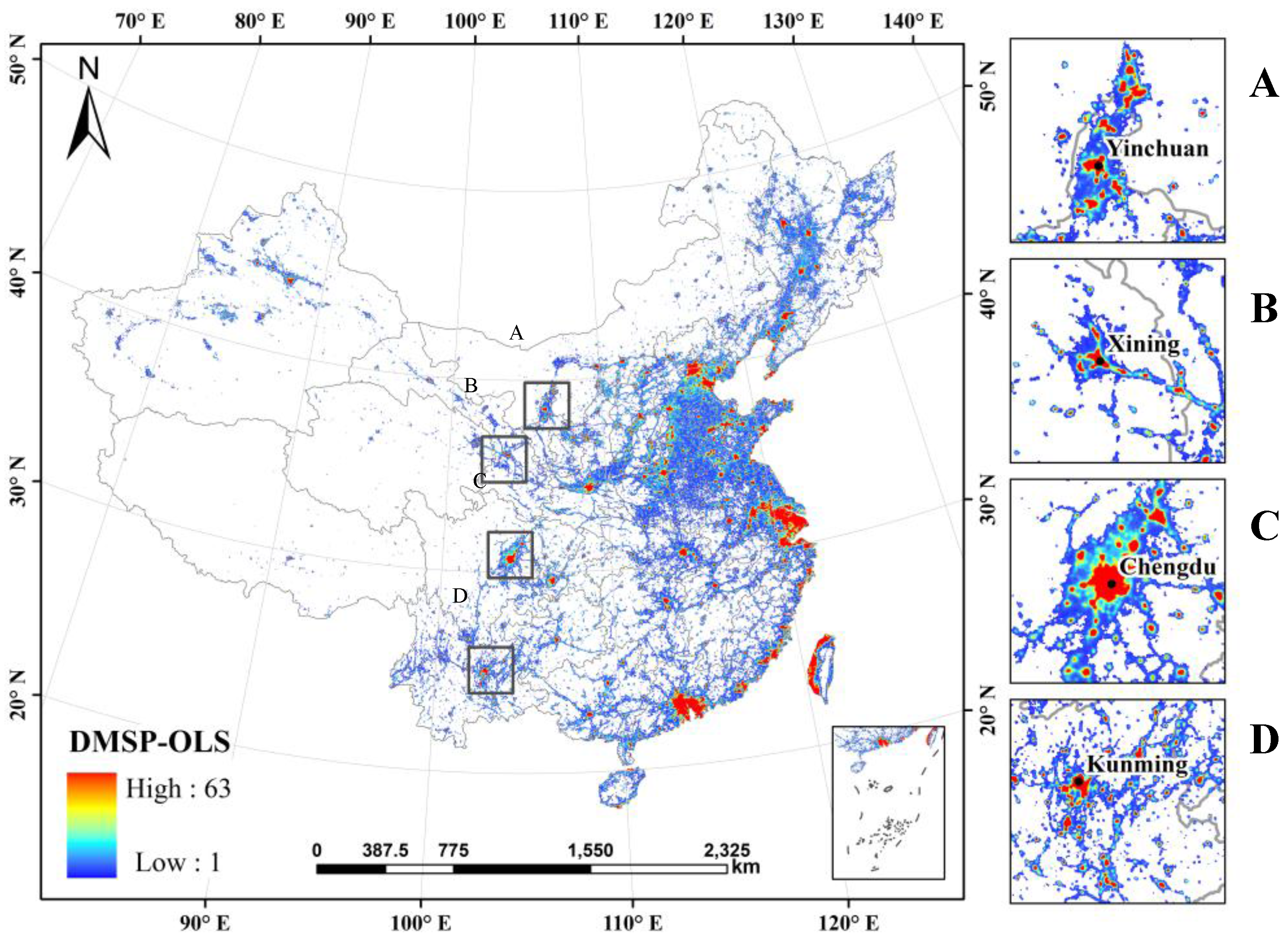
2. Study Areas and Materials
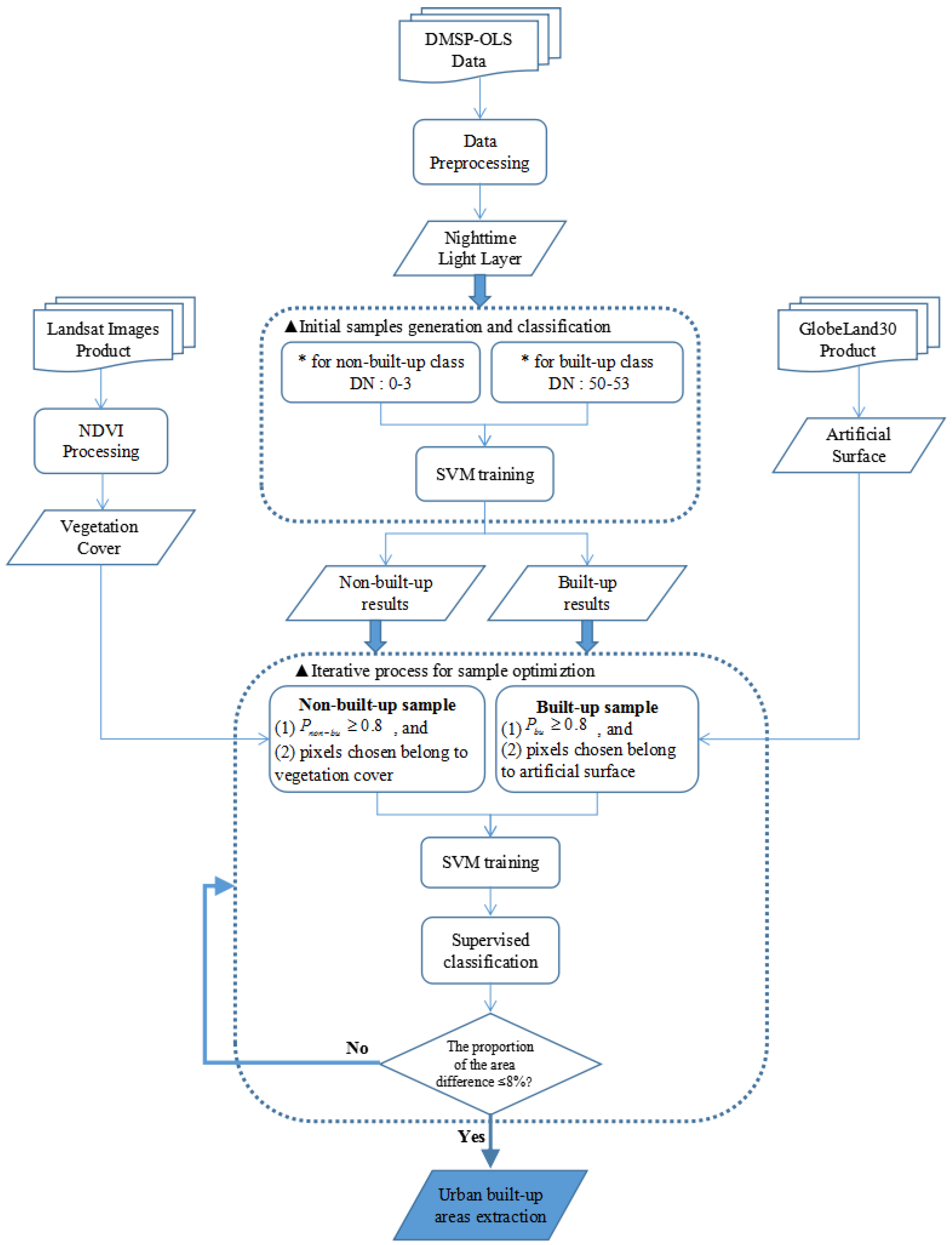
3. Methods
3.1. Data Pre-Processing
3.2. Sample Optimization in SVM Classification
3.2.1. Initial Samples Generation and Classification
3.2.2. Refined Samples Selection and Optimization
3.2.3. Iterative Classification and Urban Built-Up Area Extraction
3.3. Two Methods for Experimental Comparison
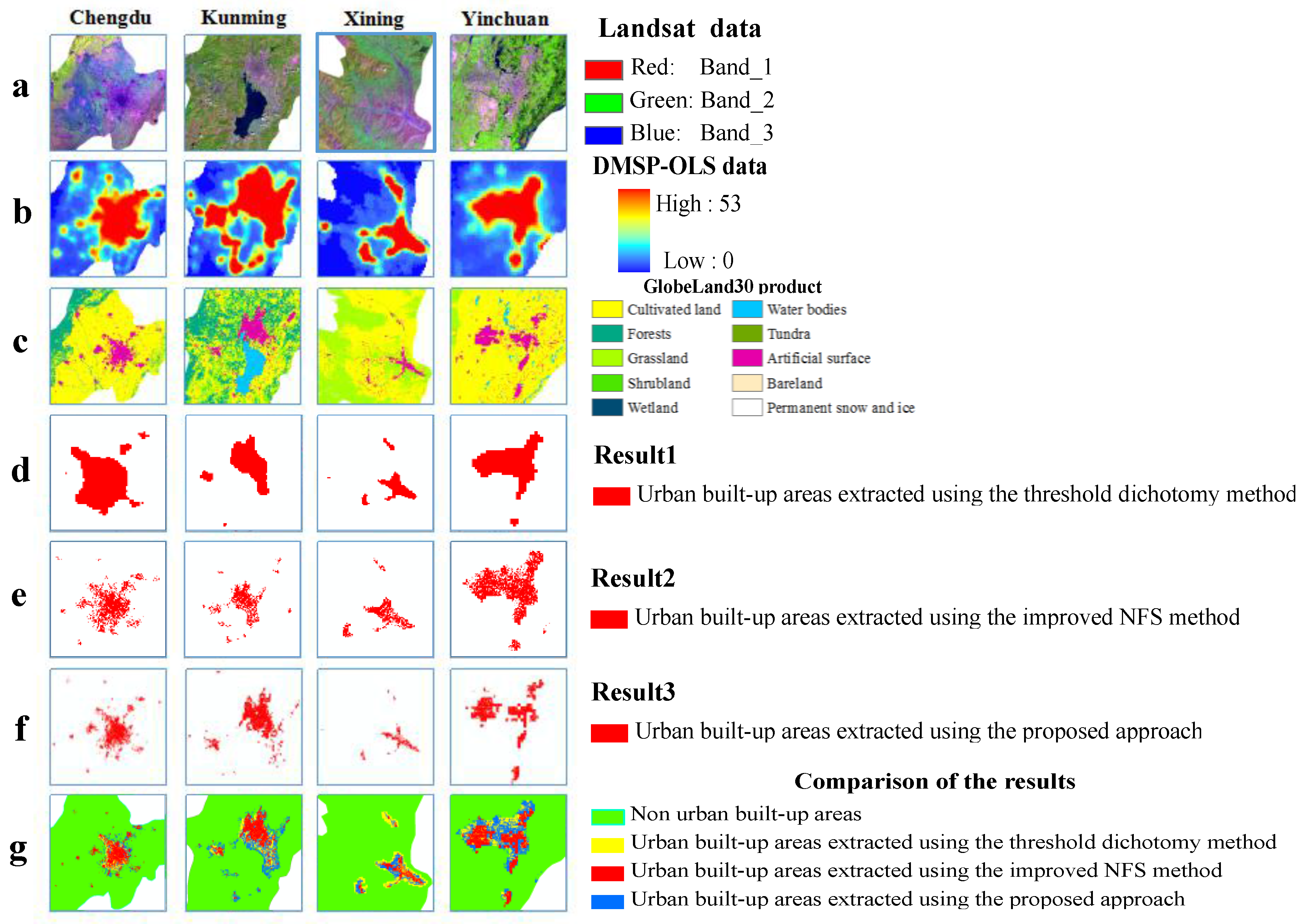
4. Experimental Results and Analysis
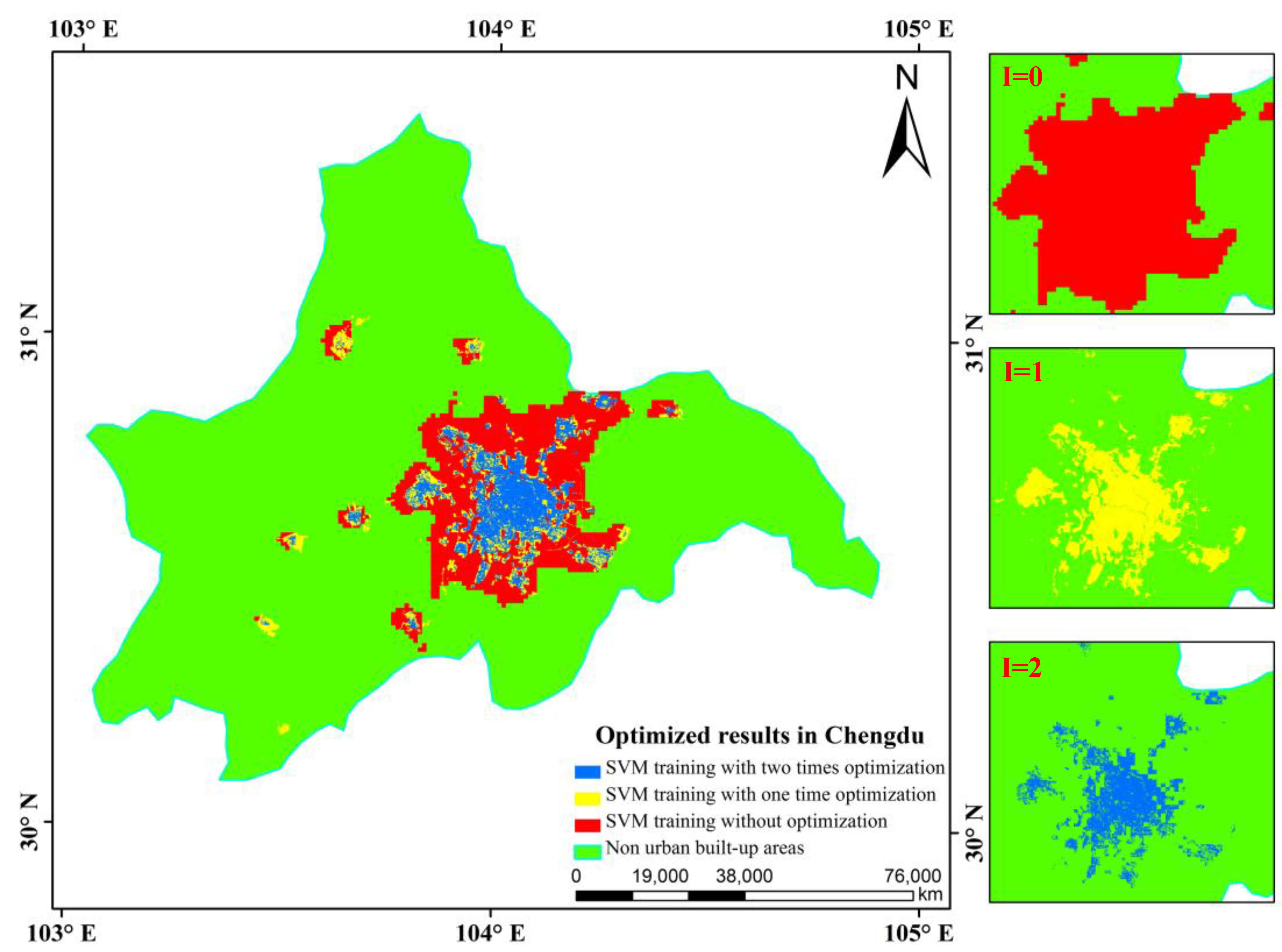
4.1. Results of Sample Optimization
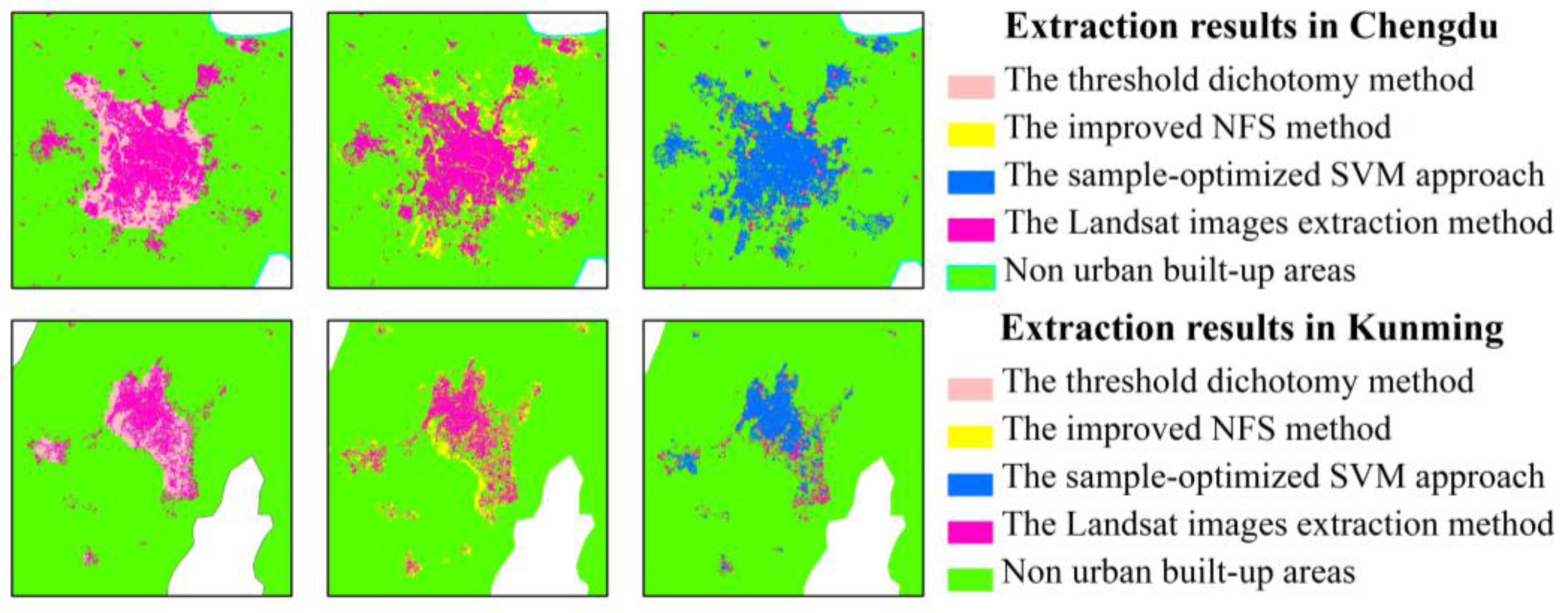
4.2. Results of Urban Built-Up Areas
4.3. Assessment of Accuracy for Urban Built-up Areas
5. Conclusions
Acknowledgments
Author Contributions
Conflicts of Interest
References
- Zhou, Y.; Smith, S.J.; Elvidge, C.D.; Zhao, K.; Thomson, A.; Imhoff, M. A cluster-based method to map urban area from DMSP/OLS nightlights. Remote Sens. Environ. 2014, 147, 173–185. [Google Scholar] [CrossRef]
- Small, C.; Elvidge, C.D. Mapping decadal change in anthropogenic night light. Procedia Environ. Sci. 2011, 7, 353–358. [Google Scholar] [CrossRef]
- Huang, X.; Schneider, A.; Friedl, M.A. Mapping sub-pixel urban expansion in China using MODIS and DMSP/OLS nighttime lights. Remote Sens. Environ. 2016, 175, 92–108. [Google Scholar] [CrossRef]
- Zhang, Q.; He, C.; Liu, Z. Studying Urban Development and Change in the Contiguous United States Using Two Scaled Measures Derived from Nighttime Lights Data and Population Census. GISci. Remote Sens. 2014, 51, 63–82. [Google Scholar] [CrossRef]
- Yu, B.; Shu, S.; Liu, H.; Song, W.; Wu, J.; Wang, L.; Chen, Z. Object-Based Spatial Cluster Analysis of Urban Landscape Pattern Using Nighttime Light Satellite Images: A Case Study of China. Int. J. Geogr. Inf. Sci. 2014, 28, 2328–2355. [Google Scholar] [CrossRef]
- Bagan, H.; Yamagata, Y. Analysis of Urban Growth and Estimating Population Density Using Satellite Images of Nighttime Lights and Land-Use and Population Data. GISci. Remote Sens. 2015, 52, 765–780. [Google Scholar] [CrossRef]
- Shao, Z.; Liu, C. The Integrated Use of DMSP-OLS Nighttime Light and MODIS Data for Monitoring Large-Scale Impervious Surface Dynamics: A Case Study in the Yangtze River Delta. Remote Sens. 2014, 6, 9359–9378. [Google Scholar] [CrossRef]
- Imhoff, M.L.; Lawrence, W.T.; Elvidge, C.D.; Paul, T.; Levine, E.; Privalsky, M.V.; Brown, V. Using nighttime DMSP/OLS images of city lights to estimate the impact of urban land use on soil resources in the U.S. Remote Sens. Environ. 1997, 59, 105–117. [Google Scholar] [CrossRef]
- Henderson, M.; Yeh, E.T.; Gong, P.; Baugh, K. Validation of Urban boundaries derived from global night-time satellite imagery. Int. J. Remote Sens. 2003, 24, 595–605. [Google Scholar] [CrossRef]
- He, C.; Shi, P.; Li, J.; Chen, J.; Pan, Y.Z.; Li, J.; Zhuo, L. Study on the reconstruction of China’s urbanization process in 1990s based on DMSP/OLS night light data and statistical data. Chin. Sci. Bull. 2006, 51, 856–861. [Google Scholar] [CrossRef]
- Gibson, J.; Gibson, G.B.; Stichbury, G. Urban land expansion in India 1992–2012. Food Policy. 2015, 56, 100–113. [Google Scholar] [CrossRef]
- Wei, Y.; Liu, H.; Song, W.; Yu, B.; Xiu, C. Normalization of time series DMSP-OLS nighttime light images for urban growth analysis with Pseudo Invariant Features. Landsc. Urban Plan. 2014, 128, 1–13. [Google Scholar] [CrossRef]
- Foody, G.M.; Mathur, A.; Sanchez-Hernandez, C.; Boyd, D.S. Training Set Size Requirements for the Classification of a Specific Class. Remote Sens. Environ. 2006, 104, 1–14. [Google Scholar] [CrossRef]
- Munoz-Mari, J.; Bruzzone, L.; Camps-Valls, G. A Support Vector domain description approach to supervised classification of remote sensing images. IEEE Trans. Geosci. Remote Sens. 2007, 45, 2683–2692. [Google Scholar] [CrossRef]
- Sanchez-Hernandez, C.; Boyd, D.S.; Foody, G.M. One-class classification for mapping a specific land-cover class: SVDD classification of fenland. IEEE Trans. Geosci. Remote Sens. 2007, 45, 1061–1073. [Google Scholar] [CrossRef]
- Cao, X.; Chen, J.; Imura, H.; Higashi, O. A SVM-based method to extract urban areas from DMSP-OLS and SPOT VGT data. Remote Sens. Environ. 2009, 113, 2205–2209. [Google Scholar] [CrossRef]
- Pandey, B.; Joshi, P.; Seto, K.C. Monitoring urbanization dynamics in India using DMSP/OLS night time lights and SPOT-VGT data. Int. J. Appl. Earth Obs. Geoinf. 2013, 23, 49–61. [Google Scholar] [CrossRef]
- Yang, Y.; He, C.; Du, S. Improving the support vector machine-based method to map urban land of China using DMSP/OLS and SPOT VGT data. IEEE Int. Geosci. Remote Sens. Symp. 2011. [Google Scholar] [CrossRef]
- Polydoros, A.; Cartalis, C. Use of earth observation based indices for the monitoring of built-up area features and dynamics in support of urban energy studies. Energy Build. 2015, 98, 92–99. [Google Scholar] [CrossRef]
- Larrañaga, A.; Álvarez-Mozos, J. On the added value of Quad-Pol Data in a multi-temporal crop classification framework based on RADARSAT-2 imagery. Remote Sens. 2016, 8, 335. [Google Scholar] [CrossRef]
- Shiraishi, T.; Motohka, T.; Thapa, R.B.; Watanabe, M.; Shimada, M. Comparative assessment of supervised classifiers for land use–land cover classification in a tropical region using time-series PALSAR Mosaic data. IEEE J. Sel. Top. Appl. Earth Obs. Remote Sens. 2014, 7, 1186–1199. [Google Scholar] [CrossRef]
- Jensen, J.R.; Fang, Q.; Patterson, K. A neural network image interpretation system to extract rural and urban land use and land cover information from remote sensor data. Geocarto Int. 2001, 16, 21–30. [Google Scholar] [CrossRef]
- Jung, J.; Pasolli, E.; Prasad, S.; Tilton, J.C.; Crawford, M.M. A Framework for land cover classification using discrete return LiDAR Data: Adopting pseudo-waveform and hierarchical segmentation. IEEE J. Sel. Top. Appl. Earth Obs. Remote Sens. 2014, 7, 491–502. [Google Scholar] [CrossRef]
- Du, P.; Liu, S.; Gamba, P.; Tan, K.; Xia, J. Fusion of Difference images for change detection over urban areas. IEEE J. Sel. Top. Appl. Earth Obs. Remote Sens. 2012, 5, 1076–1086. [Google Scholar] [CrossRef]
- Jiao, L. Urban land density function: A new method to characterize urban expansion. Landsc. Urban Plan. 2015, 139, 26–39. [Google Scholar] [CrossRef]
- Jat, M.K.; Garg, P.K.; Kharea, D. Monitoring and modeling of urban sprawl using remote sensing and GIS techniques. Int. J. Appl. Earth Obs. Geoinf. 2008, 10, 26–43. [Google Scholar] [CrossRef]
- Estoque, R.C.; Murayama, Y. Classification and change detection of built-up lands from Landsat-7 ETM+ and Landsat-8 OLI/TIRS imagery: A comparative assessment of various spectral indices. Ecol. Indic. 2015, 56, 205–217. [Google Scholar] [CrossRef]
- Hadeel, A.; Jabbar, M.; Chen, X. Application of remote sensing and GIS to the study of land use/cover change and urbanization expansion in Basrah province, southern Iraq. Geo-Spat. Inf. Sci. 2009, 12, 135–141. [Google Scholar] [CrossRef]
- Gamba, P.; Aldrighi, M.; Stasolla, M. Robust extraction of urban area extents in HR and VHR SAR images. IEEE J. Sel. Top. Appl. Earth Obs. Remote Sens. 2011, 4, 27–34. [Google Scholar] [CrossRef]
- Bedawi, S.M.; Kamel, M.S. Multiple classifier system for urban area’s extraction from high resolution remote sensing imagery. In Proceedings of the ICIAR’11 Proceedings of the 8th International Conference on Image Analysis and Recognition, Burnaby, BC, Canada, 22–24 June 2011.
- Qin, R. A Mean Shift vector-based shape feature for classification of high spatial resolution remotely sensed imagery. IEEE J. Sel. Top. Appl. Earth Obs. Remote Sens. 2015, 8, 1974–1985. [Google Scholar] [CrossRef]
- Xie, H.; Tong, X. A Probability-based improved binary encoding algorithm for classification of hyperspectral images. IEEE J. Sel. Top. Appl. Earth Obs. Remote Sens. 2014, 7, 2108–2118. [Google Scholar] [CrossRef]
- Tong, X.; Xie, H.; Weng, Q. Urban Land cover classification with airborne hyperspectral data: What features to use? IEEE J. Sel. Top. Appl. Earth Obs. Remote Sens. 2014, 7, 3998–4009. [Google Scholar] [CrossRef]
- Liao, W.; Mura, M.D.; Chanussot, J.; Pižurica, A. Fusion of Spectral and Spatial Information for Classification of Hyper-spectral Remote-Sensed Imagery by Local Graph. IEEE J. Sel. Top. Appl. Earth Obs. Remote Sens. 2016, 9, 583–594. [Google Scholar] [CrossRef]
- Arsanjani, J.J.; See, L.; Tayyebi, A. Assessing the suitability of GlobeLand30 for mapping land cover in Germany. Int. J. Digit. Earth 2016, 9, 873–891. [Google Scholar] [CrossRef]
- Lin, J.; Liu, X.; Li, K.; Li, X. A maximum entropy method to extract urban land by combining MODIS reflectance, MODIS NDVI, and DMSP-OLS data. Int. J. Remote Sens. 2014, 35, 6708–6727. [Google Scholar] [CrossRef]
- State Statistics Bureau. China City Statistical Yearbook, 2011st ed.; China Statistics Press: Beijing, China, 2011. [Google Scholar]
- Zhou, N.; Hubacek, K.; Roberts, M. Analysis of spatial patterns of urban growth across South Asia using DMSP-OLS nighttime lights data. Appl. Geogr. 2015, 63, 292–303. [Google Scholar] [CrossRef]
- Jun, C.; Jin, C.; Liao, A.; Cao, X.; Chen, J.; Chen, X.; He, C.; Han, G.; Peng, S.; Lu, M.; et al. Global land cover mapping at 30 m resolution: A POK-based operational approach. ISPRS J. Photogramm. Remote Sens. 2015, 103, 7–27. [Google Scholar]
- GLC30 Information Service. Available online: http://www.globallandcover.com (accessed on 21 February 2017).
- Housing and Urban-Rural Development. China Urban Construction Statistical Yearbook, 2011st ed.; China Planning Press: Beijing, China, 2011. [Google Scholar]
- Product Data Service Plan, Institute of Remote Sensing and Digital Earth of Chinese Academy of Sciences. Available online: http://ids.ceode.ac.cn (accessed on 28 February 2017).
- Li, Q.; Lu, L.; Weng, Q.; Xie, Y.; Guo, H. Monitoring urban dynamics in the southeast U.S.A. Using time-series DMSP/OLS nightlight imagery. Remote Sens. 2016, 8, 578. [Google Scholar] [CrossRef]
- Xiao, P.; Wang, X.; Feng, X.; Zhang, X.; Yang, Y. Detecting China’s urban expansion over the past three decades using nighttime light data. IEEE J. Sel. Top. Appl. Earth Obs. Remote Sens. 2014, 7, 4095–4106. [Google Scholar] [CrossRef]
- Cao, Z.; Wu, Z.; Kuang, Y.; Huang, N. Correction of DMSP/OLS Night-time light images and its application in China. J. Geo-Inf. Sci. 2015, 17, 1092–1102. [Google Scholar]
- Liao, L.; Song, J.; Wang, J.; Xiao, Z.; Wang, J. Bayesian method for building frequent Landsat-like NDVI datasets by integrating MODIS and Landsat NDVI. Remote Sens. 2016, 8, 452. [Google Scholar] [CrossRef]
- Brown, J.C.; Kastens, J.H.; Coutinho, A.C.; Victoria, D.D.; Bishop, C.R. Classifying multiyear agricultural land use data from Mato Grosso using time-series MODIS vegetation index data. Remote Sens. Environ. 2013, 130, 39–50. [Google Scholar] [CrossRef]
- Landmann, T.; Schramm, M.; Huettich, C.; Dech, S. MODIS-based change vector analysis for assessing wetland dynamics in Southern Africa. Remote Sens. Lett. 2013, 4, 104–113. [Google Scholar] [CrossRef]
- Pal, M.; Foody, G.M. Evaluation of SVM, RVM and SMLR for accurate image classification with limited ground data. IEEE J. Sel. Top. Appl. Earth Obs. Remote Sens. 2012, 5, 1344–1355. [Google Scholar] [CrossRef]
- Zhang, Q.; Seto, K.C. Mapping urbanization dynamics at regional and global scales using multi-temporal DMSP/OLS nighttime light data. Remote Sens. Environ. 2011, 115, 2320–2329. [Google Scholar] [CrossRef]
- Small, C.; Pozzi, F.; Elvidge, C.D. Spatial analysis of global urban extent from DMSPOLS night lights. Remote Sens. Environ. 2005, 96, 277–291. [Google Scholar] [CrossRef]
- Shi, K.; Huang, C.; Yu, B.; Yin, B.; Huang, Y.; Wu, J. Evaluation of NPP-VIIRS night-time light composite data for extracting built-up urban areas. Remote Sens. Lett. 2014, 5, 358–366. [Google Scholar] [CrossRef]
- Wu, B.; Zhang, L.; Li, P. Unmixing of hyperspectral imagery based on probabilistic outputs of support vector machines. Geomat. Inf. Sci. 2006, 31, 51–54. [Google Scholar]
- He, C.; Shi, P.; Li, J.; Chen, J.; Pan, Y.; Li, J.; Zhuo, L.; Toshiaki, I. Restoring urbanization process in China in the 1990 by using non-radiance calibrated DMSP/OLS nighttime light imagery and statistical data. Chin. Sci. Bull. 2006, 51, 1614–1620. [Google Scholar] [CrossRef]
- Liu, Z.; He, C.; Zhang, Q.; Huang, Q.; Yang, Y. Extracting the dynamics of urban expansion in China using DMSP-OLS nighttime light data from 1992 to 2008. Landsc. Urban Plan. 2012, 106, 62–72. [Google Scholar] [CrossRef]
- Shi, K.; Chen, Y.; Yu, B.; Xu, T.; Li, L.; Huang, C.; Liu, R.; Chen, Z.; Wu, J. Urban expansion and agricultural land loss in China: A Multiscale Perspective. Sustainability 2016, 8, 790–906. [Google Scholar] [CrossRef]
- Meng, L.; Graus, W.; Worrell, E.; Huang, B. Estimating CO2 (carbon dioxide) emissions at urban scales by DMSP/OLS (Defense Meteorological Satellite Program’s Operational Linescan System) nighttime light imagery: Methodological challenges and a case study for China. Energy 2014, 71, 468–478. [Google Scholar] [CrossRef]
- Tan, M. Use of an inside buffer method to extract the extent of urban areas from DMSP/OLS nighttime light data in North China. GISci. Remote Sens. 2016, 53, 444–458. [Google Scholar] [CrossRef]


| Data Source | Product Description | Spatial Resolution |
|---|---|---|
| DMSP-OLS data | Yearly stable nighttime light composite | 1 km |
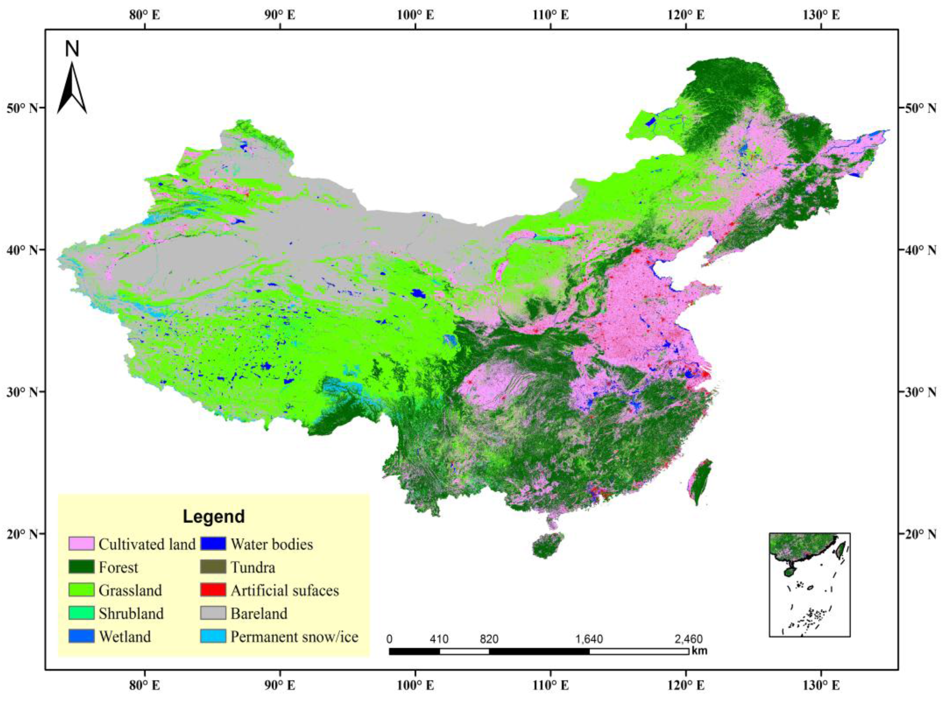
| GlobeLand30 product | Land cover types mainly include water bodies, tundra, bare land, cultivated land, forest, shrub land, grassland, permanent snow/ice, artificial surfaces, and wetland | 30 m |
| Landsat image product | Seven images covering 4 cities, band 3–5 are selected in our study | 30 m |
| Satellite Number | Year | A | b | R2 |
|---|---|---|---|---|
| F16 | 2006 | 0.8296 | 1.1883 | 0.9647 |
| 2007 | 0.7314 | 1.2132 | 0.9369 | |
| 2008 | 0.7927 | 1.1487 | 0.9186 | |
| 2009 | 0.6051 | 1.1525 | 0.8923 | |
| F18 | 2010 | 0.3427 | 1.2188 | 0.8387 |
| 2011 | 0.7035 | 1.0872 | 0.8545 | |
| 2012 | 0.4821 | 1.1866 | 0.8849 |
| Rule Properties | Pixels Belong to Artificial Surface | Pixels Belong to Vegetation Cover | ||
|---|---|---|---|---|
| Urban built-up class | √ | √ | × | × |
| Non-urban built-up class | × | × | √ | √ |
| Iteration Time (I) | Training Sample (Pixel) | Accuracy | |||
|---|---|---|---|---|---|
| Built-Up Area | Non-Built-Up Area | Producer Accuracy | User Accuracy | Overall Accuracy | |
| 0 | 572 | 4684 | 0.76 | 0.60 | 0.89 |
| 1 | 456 | 9886 | 0.59 | 0.95 | 0.92 |
| 2 | 449 | 10,058 | 0.72 | 0.97 | 0.96 |
| Region | City | Statistical Areas (km2) | Extracted Areas (km2) | Relative Error (%) |
|---|---|---|---|---|
| Western China | Chengdu | 455.56 | 423.55 | −7.03 |
| Kunming | 295.03 | 266.48 | −9.68 | |
| Xining | 66.77 | 73.35 | 9.85 | |
| Yinchuan | 120.57 | 110.62 | −8.25 |
| City | Threshold Dichotomy Method | Improved NFS Method | Sample-Optimized SVM Approach | |||||||||
|---|---|---|---|---|---|---|---|---|---|---|---|---|
| OA (%) | Kappa | CE (%) | OE (%) | OA (%) | Kappa | CE (%) | OE (%) | OA (%) | Kappa | CE (%) | OE (%) | |
| Chengdu | 89.14 | 0.54 | 13.84 | 53.94 | 91.93 | 0.67 | 32.64 | 21.43 | 96.20 | 0.80 | 3.27 | 28.13 |
| Kunming | 96.25 | 0.63 | 1.21 | 51.48 | 97.45 | 0.69 | 3.94 | 45.25 | 97.98 | 0.83 | 13.02 | 18.95 |
© 2017 by the authors. Licensee MDPI, Basel, Switzerland. This article is an open access article distributed under the terms and conditions of the Creative Commons Attribution (CC BY) license ( http://creativecommons.org/licenses/by/4.0/).
Share and Cite
Ma, X.; Tong, X.; Liu, S.; Luo, X.; Xie, H.; Li, C. Optimized Sample Selection in SVM Classification by Combining with DMSP-OLS, Landsat NDVI and GlobeLand30 Products for Extracting Urban Built-Up Areas. Remote Sens. 2017, 9, 236. https://doi.org/10.3390/rs9030236
Ma X, Tong X, Liu S, Luo X, Xie H, Li C. Optimized Sample Selection in SVM Classification by Combining with DMSP-OLS, Landsat NDVI and GlobeLand30 Products for Extracting Urban Built-Up Areas. Remote Sensing. 2017; 9(3):236. https://doi.org/10.3390/rs9030236
Chicago/Turabian StyleMa, Xiaolong, Xiaohua Tong, Sicong Liu, Xin Luo, Huan Xie, and Chengming Li. 2017. "Optimized Sample Selection in SVM Classification by Combining with DMSP-OLS, Landsat NDVI and GlobeLand30 Products for Extracting Urban Built-Up Areas" Remote Sensing 9, no. 3: 236. https://doi.org/10.3390/rs9030236
APA StyleMa, X., Tong, X., Liu, S., Luo, X., Xie, H., & Li, C. (2017). Optimized Sample Selection in SVM Classification by Combining with DMSP-OLS, Landsat NDVI and GlobeLand30 Products for Extracting Urban Built-Up Areas. Remote Sensing, 9(3), 236. https://doi.org/10.3390/rs9030236