1. Introduction
Remotely sensed data are extensive exploited for the estimation of environmental variables of relevance to human health. Since the launch of Landsat-1 in 1972 [
1], an increasing number of health studies have used remotely sensed data for monitoring, surveillance, or risk assessment. This data, associated with image processing techniques, is very helpful to understand the transmission mechanisms of several diseases and could be used to develop satellite data-based early warning systems [
2].
Most of the health studies involving remote sensed data were related to parasitic diseases and refer to the pathogen, studying the presence or absence of the specific vectors [
2]. Malaria is one of the most common vector-borne diseases in the world, with an estimated 214 million new cases and 438,000 deaths in 2015 [
3], and therefore is one of the most studied diseases from the remote sensing point of view (e.g., [
4,
5]). For some infectious diseases of major public health importance (e.g., Dengue fever) and other highly pathogenic or emerging infectious diseases (e.g., Ebola fever), remote sensing has become in recent years a very powerful instrument [
6,
7]. Also, an extensive use of remote sensing data is recorded in the study of neglected tropical diseases [
8]. Recently, several studies have related different environmental factors (e.g., humidity, temperature, particulate matter of 10 micrometers or less (PM10), Nitrogen Dioxide (NO
2)) retrieved by remote sensing data with other diseases, such as asthma exacerbations [
9], preterm birth [
10], circulatory mortality and ischemic heart disease [
11], or diabetes [
12].
During the last years, the quantity and variety of remotely sensed and in situ environmental data (e.g., measuring human activity) [
13,
14] have greatly increased. This growth was followed by a significant increase in the scientific publications associated with these works [
15]. Several studies show that the analysis of published literature could provide critical information about the research production and the scientific quality [
16,
17,
18,
19]. Moreover, we believe that describing trends and characteristics of the articles from a scientific field can trigger the future research and collaborations between authors and institutions.
There are already bibliometric analyses of global remote sensing [
15]. However, there is no study, to the best of our knowledge, that has specifically investigated its relation to health.
The goal of this paper was to perform a bibliometric analysis, using a systematic review approach, regarding the application of remote sensing data to human health to appraise the publication, research trends, and characteristics in this field.
2. Material and Methods
2.1. Bibliographic Database
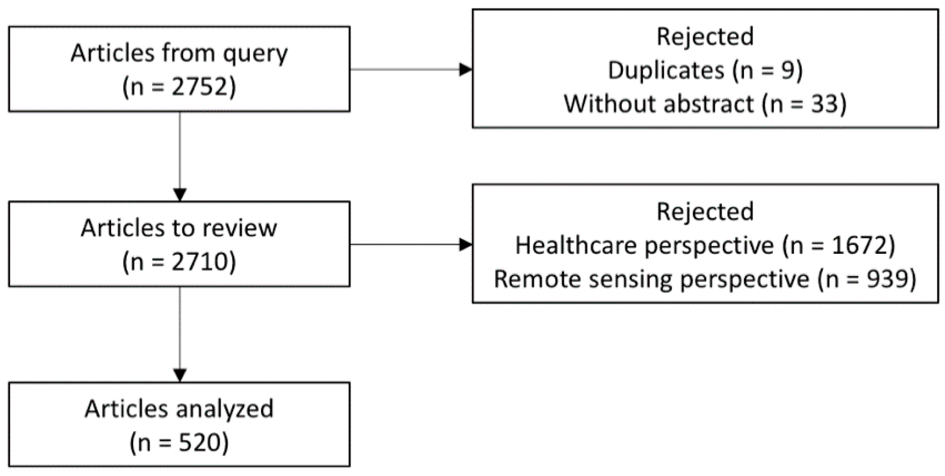
Scopus is one of the world’s largest abstract and citation databases of peer-reviewed research literature, with over 22,000 titles from more than 5000 international publishers. Furthermore, Scopus has a wide coverage, currently counting 22,794 peer-reviewed journals; it has efficient tools for retrieving and aggregating information; and it exports data in multiple formats based on previously defined output variables and provides extensive information for analysis [
20]. For these reasons, Scopus was the database of peer-reviewed literature chosen for this research.
Scopus also provides relevant functionalities, namely the field “source type”, in which the user is able to refine search results by the type of data source, such as journal publications, books, book chapters, and conference proceedings. In this study, we limited our analysis to journal publications and reviews. Conference proceedings, books, and book chapters were not considered for analysis because they include works that might have been published more than once, in different sources. For instance, books or book chapters usually contain one or more studies that might have been published elsewhere and conference proceedings include abstracts that might have been published in scientific journals. Thus, limiting our analysis to journal publications was essential for addressing potential bias caused by duplicate publications, minimizing false positive results. Synthesis studies e.g., systematic reviews, comprise studies published elsewhere; however, they were included in our analysis because they are regarded as original studies.
2.2. Search Strategy and Validity
Besides limiting our search to reviews and journal publications, we only considered documents whose publication year occurred between 2007 and 2016 (a 10-year study). We selected only studies regarding the application of remote sensing technology in human health, including healthcare services. In order to retrieve complete and suitable publications data from Scopus, we built the search query based on two main pillars regarding medical and remote sensing as two broad concepts.
The search firstly accounted for remote sensing publications and was implemented as follows: retrieve all documents either containing “Remot* sens*” or “satellite imag*” or “aerial photograph*” or “space-borne sensor*” or “Earth Observation Satellite*” or “Earth Resources Satellite*” in the title, abstract or keyword, in which the wild card “*” was used to address plurals and certain word variations (e.g., sensing, sensors, and sensor). The implementation of the search within the medical field combined two approaches in order to maximize sensitivity. The first approach implemented a broader search aimed to retrieve all journal publications that presented “Health Care” or “HealthCare” terms in the title, abstract or as keyword, combined with an extensive list of diseases and medical conditions. This list of diseases and medical conditions was obtained through the aggregation of all diseases defined by the International Classification of Diseases 9th Revision Clinical Modification (ICD-9-CM) terminology, a list of diseases from the Centers for Disease Control and Prevention (CDC), and an additional list of Medical Subject Headings (MeSH) terms under the C category, which describes all diseases in the mesh tree structures of PubMed. Common diseases among ICD-9-CM terminology, CDC, and Category C of Mesh terms were merged, and non-specific disease terms such as “eye” and “arm” were removed. It is important to highlight that limiting the search to title, abstracts, and keywords was necessary to increase specificity and due to the exhaustive list of diseases included in the query.
We conducted a manual review of all retrieved documents in order to address word ambiguity issues. For instance, several terms related to the medical field, such as depression, AIDS, and burns, may overlap with concepts from other scientific fields, retrieving false positive results. Additionally, the search results from “remote sensing” might include publications on remote monitoring of devices, which are not related to the concept of remote sensing in the context of our study.
The systematic review was conducted independently by six reviewers. All documents resulted from our search were reviewed under two perspectives: four reviewers performed the review under the medical perspective and two under the remote sensing perspective. Under the medical perspective, the inclusion criteria were: “any publication related to human health, which comprised those articles with a main focus on human health, any specific disease or medical condition, risk factor for disease or healthcare services”.
Under the remote sensing perspective, the reviewers used as inclusion criteria “any publication regarding any imagery obtained by Earth observation systems”. Divergences between the two remote sensing reviewers were resolved through reaching a consensus. Under the medical perspective, each article was analyzed by two reviewers and a third reviser resolved divergences. Only the papers that were accepted by the remote sensing reviewers and by healthcare reviewers were included in the final analysis.
2.3. Software and Data Analysis
At the manual review stage, Cohen’s kappa statistics was calculated to appraise interrater reliability.
All articles that were included after the manual review were analyzed by authorship, country, sources, affiliation, and citations. Individual keywords were assessed by frequency and a ranking of publication sources was performed by relevance. A list of diseases or human conditions were also selected from the keywords and analyzed. Productivity analysis was conducted by author and country rankings. Total and average number of citations was analyzed by country.
Authorship analysis was carried out by computing the number of single-authored articles and multi-authored publications. We also calculated the rate of articles per author, authors per article, and co-authors per articles. Overall collaboration and the frequency publications cited together i.e., co-citations, were also analyzed.
VOSviewer program, a software tool designed specifically for bibliometric analysis, was employed for the visualization of the retrieved data. This tool provides a density map in which a color represents clusters (e.g., countries or authors) connecting lines to indicate certain parameters (e.g., strength of collaboration between countries or authors are measured and represented by the thickness of connecting lines). The circle size or font size indicates the level of productivity or citations. On selecting the unit of analysis, thresholds were imposed for the visualization to be intelligible.
The software Microsoft Excel was used to rearrange the data and perform the analysis of the exported data (i.e., comma separated values’ table) from Scopus and the software R was used to plot charts. Moreover, for network visualization of the analysis, the software VOSviewer was used.
2.4. Statistics and Ethical Considerations
This study was exempted from ethical approval as no human individuals were included and only publicly available electronic data was used for analysis.
4. Discussion
Remote sensing images are a very useful source of data to understand the transmission mechanisms of several diseases. In this study, we performed a bibliometric analysis with a systematic review of remote sensing research applied to health in order to give a clear overview of research trends in this field. Although a few articles were published using this methodology in remote sensing research [
15,
18,
19], to the best of our knowledge, this is the first one applied to health.
When considering keywords, the most frequent health research areas were related to malaria, dengue, and schistosomiasis, and so these keywords can be used as surrogates to indicate the most common researched diseases, in particular vector-borne diseases.
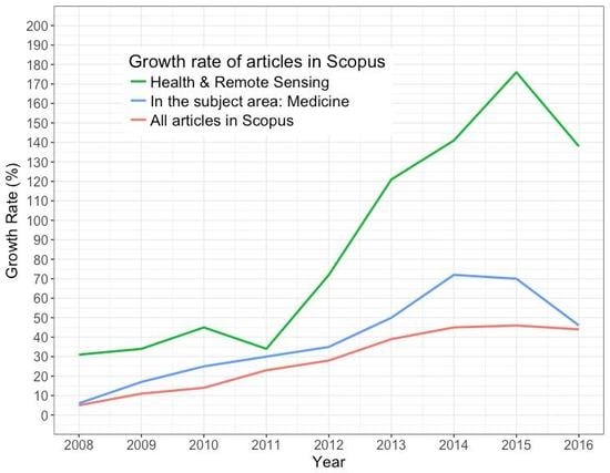
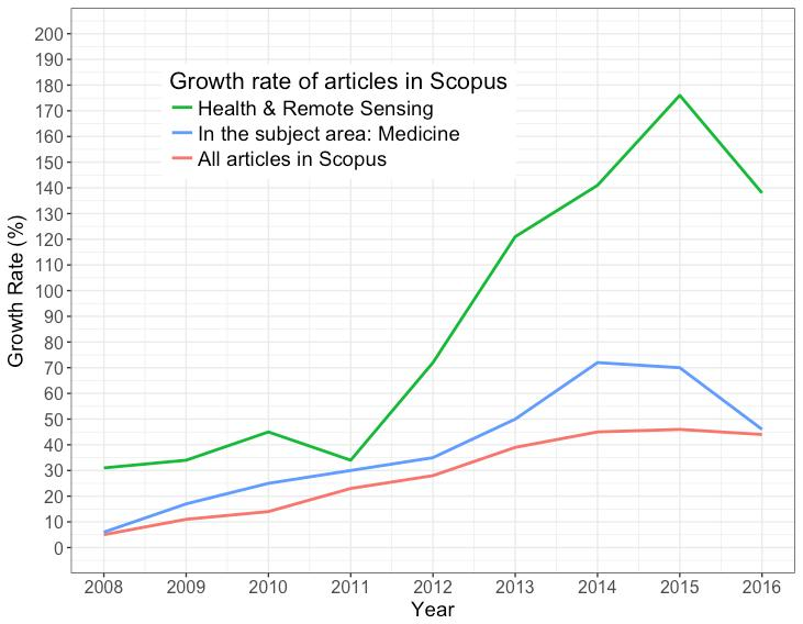
During the study period, the research productivity regarding remote sensing data to human health had a substantial increase, reaching an increase of 176% (2015) when compared to the initial year. This result is even more impressive when compared to the overall trend of publications in Scopus, which increased 46% (2015), and even when compared to the publications in Scopus in the subject area of Medicine, which increased 72% (2014). This trend reflects a mounting interest and research investment in the field.
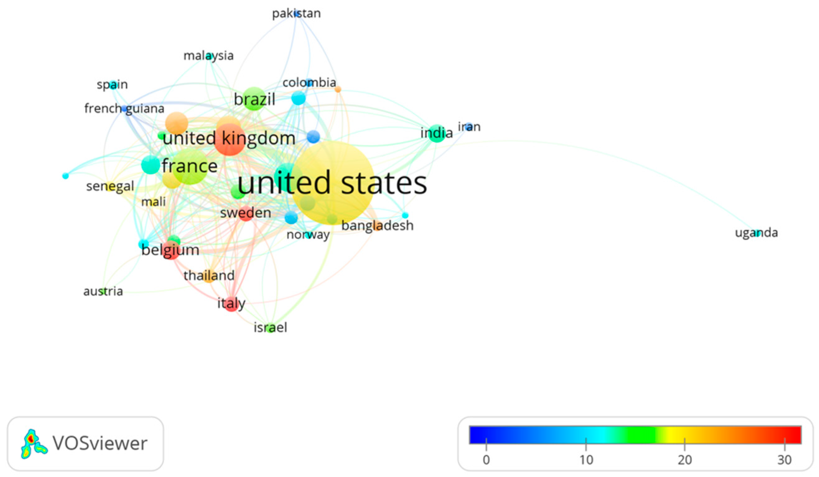
The countries who stand out for its volume of research were the United States, France, and the United Kingdom. However, when increasing the granularity of the analysis to the institution, it is clear that Swiss Tropical and Public Health Institute and University of Basel in Switzerland are leading institutions in this field.
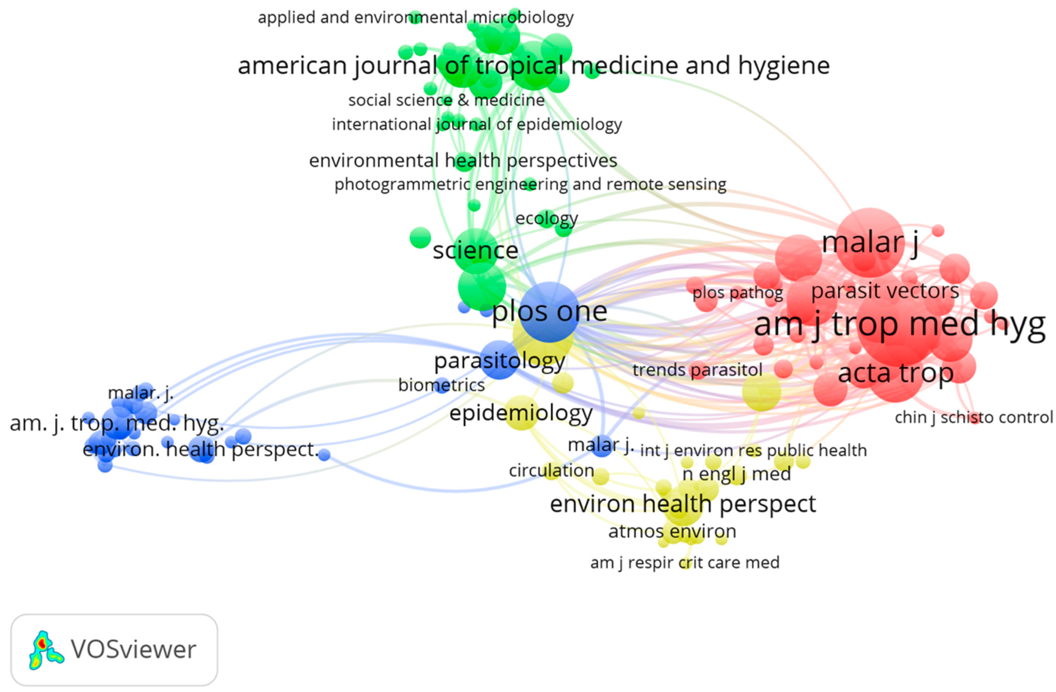
The majority of these articles were published in remote sensing and/or technology journals rather than in medical journals, which might reflect the ignorance or the fact that this research topic might be considered less important by the medical field.
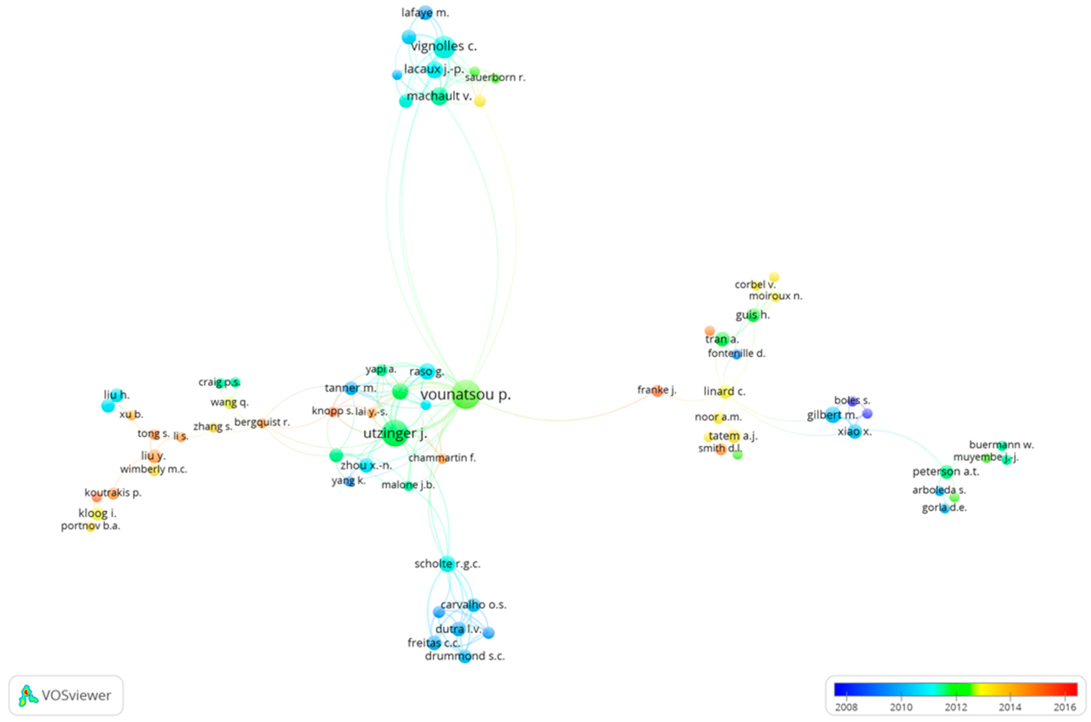
Regarding authorship, Vounatsou P. was the most prolific author in this field. However, Vignolles C. made most of her research in the field of remote sensing applied to health, indicating a greater investment and interest in the field.
In fact, the high burden of infectious diseases in developing countries [
21], allied to the fact that this disease group can be easily studied by means of remote sensing, might be a good public health indicator for their prevention and control. The timing of this study is important, as bringing attention to this topic might help some countries in their mission to achieve Sustained Development Goals proposed by the World Health Organization to be reached by 2030 [
22]. However, the use of remote sensing data in public health issues (i.e., infectious diseases) has already been pointed out [
23]. In so-called “environmental” diseases, geographical information systems (GIS) are highly applicable, while in the non-communicable category its applicability is quite limited. This and the fact that regions such as Africa have a great burden of these diseases can explain the collaboration and location of the research on this field [
24].
It is known that health geomatics can be a good tool to improve health resources allocation, as a good relation between location and healthcare triggers disease prevention and improves health planning and policy [
25]. Furthermore, GIS are being more often used in public health with a clear advantage of depicting complex analyses on a map, but some disadvantages such as trained staff, appropriate spatial units, and/or patient confidentiality [
26].
While developing this paper, we were faced with many challenges, the most difficult one being the establishment of a definition of human health, requiring the authors to sort through more than 8000 medical concepts to perform an adequate search. The search itself presented a challenge because of the massive number of search terms and the search engine limitations. Despite this effort, and due to the duality of some concepts (e.g., burn, depression, and AIDS), we reviewed the abstracts manually to end up with more accurate and appropriate results.
Our study had some limitations. Firstly, we performed this bibliometric analysis only in Scopus. Although Scopus is one of the largest databases, some research in this field might be indexed in other databases, not indexed at all, or might have not yet been published in article format (e.g., only presented in congresses). Furthermore, adding results from searches in other databases would be feasible but very time consuming and, most likely, would not have provided added value to the results. Secondly, a limitation inherent to the query cannot be ignored, as false-negatives might be present with some articles being excluded, though we tried to overcome this limitation by using a sensitive query regarding both health and remote sensing. Moreover, one strength of our study is that all articles were reviewed manually by at least two reviewers in each perspective, minimizing the possibility that a false-positive article would be included. Thirdly, authors and institutions’ rankings may not be completely correct, as some have different name spellings or initials. Finally, we used in VOSviewer a minimum threshold number to draw graphics, excluding some items; this choice was made after several iterations, with the aim of maximizing the balance between the amount of information included in the visualization and readability.
5. Conclusions
Earth observation data have demonstrated a great value in providing crucial information to understand health issues. Remote sensing along with GIS has multiple applications in the healthcare area, particularly for vector-borne diseases. In fact, for some infectious diseases and other highly pathogenic or emerging infectious diseases, remote sensing has become a very powerful instrument, providing spatial information on environmental conditions for understanding influences in health. Also, several studies relate different environmental factors retrieved by remote sensing data with other diseases, such as asthma exacerbations. Health-related remote sensing publications are increasing and this paper highlights the importance of these related technologies toward better information and, ideally, better provision of healthcare. On the other hand, this paper provides an overall picture of the state of the research regarding the application of remote sensing data in human health and identifies the most active stakeholders e.g., authors and institutions in the field, informing possible new collaboration research groups.
The present work lays the ground for several research directions, namely systematic reviews comparing methodologies of remote sensing applied to tracking specific diseases, remote sensing’s impact on public health, and the evolution of remote sensing methods over the years. Furthermore, and based on the manual classification of articles, other methodological approaches can be explored (e.g., text mining).

 ,
, 


