Remote Sensing in Human Health: A 10-Year Bibliometric Analysis
by
 , , and
João Viana
1,2, 
João Vasco Santos
1,2,
Rui Manuel Neiva
1,2,
Júlio Souza
1,2,
Lia Duarte
3,4,
Ana Cláudia Teodoro
3,4 and
and
Alberto Freitas
1,2,* 1
Department of Community Medicine, Information and Health Decision Sciences, Faculty of Medicine, University of Porto, 4200-450 Porto, Portugal
2
Centre for Health Technology and Services Research, 4200-450 Porto, Portugal
3
Department of Geosciences, Environment and Land Planning, Faculty of Sciences, University of Porto, 4169-007 Porto, Portugal
4
ICT—Institute of Earth Sciences, Faculty of Sciences, University of Porto, 4169-007 Porto, Portugal
*
Author to whom correspondence should be addressed.
Remote Sens. 2017, 9(12), 1225; https://doi.org/10.3390/rs9121225
Submission received: 28 September 2017
/
Revised: 20 November 2017
/
Accepted: 23 November 2017
/
Published: 28 November 2017
Abstract
:A mixed methods bibliometric analysis was performed to ascertain the characteristic of scientific literature published in a 10-year period (2007–2016) regarding the application of remote sensing data in human health. A search was performed on the Scopus database, followed by manual revision using synthesis studies’ techniques, requiring the authors to sort through more than 8000 medical concepts to create the query, and to manually select relevant papers from over 2000 documents. From the initial 2752 papers identified, 520 articles were selected for analysis, showing that the United States ranked first, with a total of 250 (48.1% of the total) documents, followed by France and the United Kingdom, with 67 (12.9% of the total) and 54 (10.4% of the total) documents, respectively. When considering authorship, the top three authors were Vounatsou P (22 articles), Utzinger J (19 articles), and Vignolles C (13 articles). Regarding disease-specific keywords, malaria, dengue, and schistosomiasis were the most frequent keywords, occurring 142, 34, and 24 times, respectively. For some infectious diseases and other highly pathogenic or emerging infectious diseases, remote sensing has become a very powerful instrument. Also, several studies relate different environmental factors retrieved by remote sensing data with other diseases, such as asthma exacerbations. Health-related remote sensing publications are increasing and this paper highlights the importance of these related technologies toward better information and, ideally, better provision of healthcare. On the other hand, this paper provides an overall picture of the state of the research regarding the application of remote sensing data in human health and identifies the most active stakeholders e.g., authors and institutions in the field, informing possible new collaboration research groups.
1. Introduction
Remotely sensed data are extensive exploited for the estimation of environmental variables of relevance to human health. Since the launch of Landsat-1 in 1972 [1], an increasing number of health studies have used remotely sensed data for monitoring, surveillance, or risk assessment. This data, associated with image processing techniques, is very helpful to understand the transmission mechanisms of several diseases and could be used to develop satellite data-based early warning systems [2].
Most of the health studies involving remote sensed data were related to parasitic diseases and refer to the pathogen, studying the presence or absence of the specific vectors [2]. Malaria is one of the most common vector-borne diseases in the world, with an estimated 214 million new cases and 438,000 deaths in 2015 [3], and therefore is one of the most studied diseases from the remote sensing point of view (e.g., [4,5]). For some infectious diseases of major public health importance (e.g., Dengue fever) and other highly pathogenic or emerging infectious diseases (e.g., Ebola fever), remote sensing has become in recent years a very powerful instrument [6,7]. Also, an extensive use of remote sensing data is recorded in the study of neglected tropical diseases [8]. Recently, several studies have related different environmental factors (e.g., humidity, temperature, particulate matter of 10 micrometers or less (PM10), Nitrogen Dioxide (NO2)) retrieved by remote sensing data with other diseases, such as asthma exacerbations [9], preterm birth [10], circulatory mortality and ischemic heart disease [11], or diabetes [12].
During the last years, the quantity and variety of remotely sensed and in situ environmental data (e.g., measuring human activity) [13,14] have greatly increased. This growth was followed by a significant increase in the scientific publications associated with these works [15]. Several studies show that the analysis of published literature could provide critical information about the research production and the scientific quality [16,17,18,19]. Moreover, we believe that describing trends and characteristics of the articles from a scientific field can trigger the future research and collaborations between authors and institutions.
There are already bibliometric analyses of global remote sensing [15]. However, there is no study, to the best of our knowledge, that has specifically investigated its relation to health.
The goal of this paper was to perform a bibliometric analysis, using a systematic review approach, regarding the application of remote sensing data to human health to appraise the publication, research trends, and characteristics in this field.
2. Material and Methods
2.1. Bibliographic Database
Scopus is one of the world’s largest abstract and citation databases of peer-reviewed research literature, with over 22,000 titles from more than 5000 international publishers. Furthermore, Scopus has a wide coverage, currently counting 22,794 peer-reviewed journals; it has efficient tools for retrieving and aggregating information; and it exports data in multiple formats based on previously defined output variables and provides extensive information for analysis [20]. For these reasons, Scopus was the database of peer-reviewed literature chosen for this research.
Scopus also provides relevant functionalities, namely the field “source type”, in which the user is able to refine search results by the type of data source, such as journal publications, books, book chapters, and conference proceedings. In this study, we limited our analysis to journal publications and reviews. Conference proceedings, books, and book chapters were not considered for analysis because they include works that might have been published more than once, in different sources. For instance, books or book chapters usually contain one or more studies that might have been published elsewhere and conference proceedings include abstracts that might have been published in scientific journals. Thus, limiting our analysis to journal publications was essential for addressing potential bias caused by duplicate publications, minimizing false positive results. Synthesis studies e.g., systematic reviews, comprise studies published elsewhere; however, they were included in our analysis because they are regarded as original studies.
2.2. Search Strategy and Validity
Besides limiting our search to reviews and journal publications, we only considered documents whose publication year occurred between 2007 and 2016 (a 10-year study). We selected only studies regarding the application of remote sensing technology in human health, including healthcare services. In order to retrieve complete and suitable publications data from Scopus, we built the search query based on two main pillars regarding medical and remote sensing as two broad concepts.
The search firstly accounted for remote sensing publications and was implemented as follows: retrieve all documents either containing “Remot* sens*” or “satellite imag*” or “aerial photograph*” or “space-borne sensor*” or “Earth Observation Satellite*” or “Earth Resources Satellite*” in the title, abstract or keyword, in which the wild card “*” was used to address plurals and certain word variations (e.g., sensing, sensors, and sensor). The implementation of the search within the medical field combined two approaches in order to maximize sensitivity. The first approach implemented a broader search aimed to retrieve all journal publications that presented “Health Care” or “HealthCare” terms in the title, abstract or as keyword, combined with an extensive list of diseases and medical conditions. This list of diseases and medical conditions was obtained through the aggregation of all diseases defined by the International Classification of Diseases 9th Revision Clinical Modification (ICD-9-CM) terminology, a list of diseases from the Centers for Disease Control and Prevention (CDC), and an additional list of Medical Subject Headings (MeSH) terms under the C category, which describes all diseases in the mesh tree structures of PubMed. Common diseases among ICD-9-CM terminology, CDC, and Category C of Mesh terms were merged, and non-specific disease terms such as “eye” and “arm” were removed. It is important to highlight that limiting the search to title, abstracts, and keywords was necessary to increase specificity and due to the exhaustive list of diseases included in the query.
We conducted a manual review of all retrieved documents in order to address word ambiguity issues. For instance, several terms related to the medical field, such as depression, AIDS, and burns, may overlap with concepts from other scientific fields, retrieving false positive results. Additionally, the search results from “remote sensing” might include publications on remote monitoring of devices, which are not related to the concept of remote sensing in the context of our study.
The systematic review was conducted independently by six reviewers. All documents resulted from our search were reviewed under two perspectives: four reviewers performed the review under the medical perspective and two under the remote sensing perspective. Under the medical perspective, the inclusion criteria were: “any publication related to human health, which comprised those articles with a main focus on human health, any specific disease or medical condition, risk factor for disease or healthcare services”.
Under the remote sensing perspective, the reviewers used as inclusion criteria “any publication regarding any imagery obtained by Earth observation systems”. Divergences between the two remote sensing reviewers were resolved through reaching a consensus. Under the medical perspective, each article was analyzed by two reviewers and a third reviser resolved divergences. Only the papers that were accepted by the remote sensing reviewers and by healthcare reviewers were included in the final analysis.
2.3. Software and Data Analysis
At the manual review stage, Cohen’s kappa statistics was calculated to appraise interrater reliability.
All articles that were included after the manual review were analyzed by authorship, country, sources, affiliation, and citations. Individual keywords were assessed by frequency and a ranking of publication sources was performed by relevance. A list of diseases or human conditions were also selected from the keywords and analyzed. Productivity analysis was conducted by author and country rankings. Total and average number of citations was analyzed by country.
Authorship analysis was carried out by computing the number of single-authored articles and multi-authored publications. We also calculated the rate of articles per author, authors per article, and co-authors per articles. Overall collaboration and the frequency publications cited together i.e., co-citations, were also analyzed.
VOSviewer program, a software tool designed specifically for bibliometric analysis, was employed for the visualization of the retrieved data. This tool provides a density map in which a color represents clusters (e.g., countries or authors) connecting lines to indicate certain parameters (e.g., strength of collaboration between countries or authors are measured and represented by the thickness of connecting lines). The circle size or font size indicates the level of productivity or citations. On selecting the unit of analysis, thresholds were imposed for the visualization to be intelligible.
The software Microsoft Excel was used to rearrange the data and perform the analysis of the exported data (i.e., comma separated values’ table) from Scopus and the software R was used to plot charts. Moreover, for network visualization of the analysis, the software VOSviewer was used.
2.4. Statistics and Ethical Considerations
This study was exempted from ethical approval as no human individuals were included and only publicly available electronic data was used for analysis.
3. Results
3.1. General Information
A total of 2752 documents were retrieved. A manual review of all retrieved documents (title and abstract) was performed under the medical and the remote sensing perspectives in order to exclude potential false positive results. Under the medical perspective, the Cohen’s kappa statistics was 0.78 (95% confidence interval (CI) = 0.75–0.81), whereas under the remote sensing perspective reviewers reached a similar level of interrater reliability with a Cohen’s kappa statistics of 0.75 (95% CI = 0.72–0.79). The final set of articles was of 520 articles (19.9% of total). Figure 1 shows a summary of the review process results.
The vast majority of the retrieved documents were published in English (505 documents; 96.7%), though other common languages were encountered, followed by Portuguese (six documents; 1.1%), Chinese (four documents; 0.8%) and French (four documents; 0.8%). Retrieved articles received a total of 8034 citations, corresponding to a mean of 15.5 citations per document. A total of 472 (90.8%) articles were cited at least once, while the remaining 48 (9.2%) publications were not cited at all.
Regarding disease-specific keywords, malaria, dengue, and schistosomiasis were the most frequent keywords, occurring 142, 35, and 34 times respectively. More disease-specific keywords can be seen in Table 1.
3.2. Trends and Citations
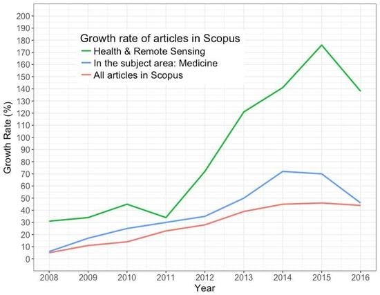
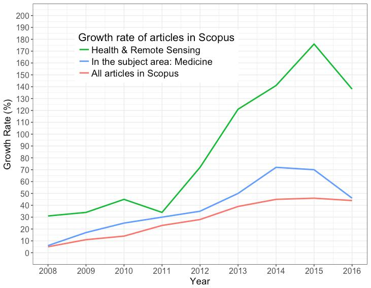
Throughout the period considered in our study, the average number of publications was 52 documents per year. An increasing trend of the number of publications was observed over the years (Table 2). The peak of productivity was observed in 2015, with a total of 80 publications, which comprised 15.4% of the total productivity in the studied period. Table 2 summarizes yearly scientific production and citations, while Figure 2 shows the growth rate of publications (referenced to 2007), comparing the growth between health and remote sensing, the publications indexed in Scopus with the subject area: Medicine, and the total publications indexed in Scopus.
The article that received the highest number of citations was “Mapping H5N1 highly pathogenic avian influenza risk in Southeast Asia”, with a total of 196 citations published in the Proceedings of the National Academy of Sciences of the United States of America in 2010. A list the most referenced publications by articles in field of remote sensing applied to human health is presented in Table 3. Figure 3 shows a network for co-citation analysis.
3.3. Geographical Distribution
In order to visualize collaboration nets and the distribution of publications across the world regarding publications on the application of remote sensing technology in human health, we constructed a bibliometric network represented in Figure 4. Researchers from 39 different countries with connections with each other contributed to the publication of the selected documents. The United States ranked first, with a total of 250 (48.1% of the total) documents, followed by France and the United Kingdom, with 67 (12.9% of the total) and 54 (10.4% of the total) documents, respectively. When only the number of citations is considered, the United States (4755 citations; average article citations of 19.0) also presented the highest number, followed by France (1155 citations; average article citations of 17.2) and the United Kingdom (1500 citations; average article citations of 27.8).
Taking into account author’s affiliation, there are no institutions or organizations that have concentrated most of the publications in the field of remote sensing applied to human health, with 1928 different institutions or organizations having published at least one manuscript in this research field, with was an average of 3.7 institutions or organizations per publication. Swiss Tropical and Public Health Institute, Switzerland and University of Basel, Switzerland ranked first as the most productive institutions. The number of publications per institution is presented in Table 4.
The selected publications on remote sensing applied to healthcare were published by a total of 134 different sources. Table 5 lists all preferred journals, with a minimum productivity of 10 documents. Malaria Journal ranked first, with 39 (7.5% of the total) documents, followed by International Journal of Health Geographics, with 35 publications (6.5% of the total), and PLoS ONE, with 32 manuscripts (6.2% of the total).
3.4. Authorship Pattern and Collaboration
A total of 2479 researchers participated in the retrieved documents regarding the application of remote sensing technology to human health, which corresponds to a mean of 4.76 authors per document. Single-authored documents comprised a total of 11 (2.11% of the total) publications. Additionally, authors with a minimum productivity of three documents were graphically represented using an algorithm implemented by VOSviewer, as shown in Figure 5. Table 6 lists the top 10 active authors in the field of remote sensing applied to human health.
4. Discussion
Remote sensing images are a very useful source of data to understand the transmission mechanisms of several diseases. In this study, we performed a bibliometric analysis with a systematic review of remote sensing research applied to health in order to give a clear overview of research trends in this field. Although a few articles were published using this methodology in remote sensing research [15,18,19], to the best of our knowledge, this is the first one applied to health.
When considering keywords, the most frequent health research areas were related to malaria, dengue, and schistosomiasis, and so these keywords can be used as surrogates to indicate the most common researched diseases, in particular vector-borne diseases.
During the study period, the research productivity regarding remote sensing data to human health had a substantial increase, reaching an increase of 176% (2015) when compared to the initial year. This result is even more impressive when compared to the overall trend of publications in Scopus, which increased 46% (2015), and even when compared to the publications in Scopus in the subject area of Medicine, which increased 72% (2014). This trend reflects a mounting interest and research investment in the field.
The countries who stand out for its volume of research were the United States, France, and the United Kingdom. However, when increasing the granularity of the analysis to the institution, it is clear that Swiss Tropical and Public Health Institute and University of Basel in Switzerland are leading institutions in this field.
The majority of these articles were published in remote sensing and/or technology journals rather than in medical journals, which might reflect the ignorance or the fact that this research topic might be considered less important by the medical field.
Regarding authorship, Vounatsou P. was the most prolific author in this field. However, Vignolles C. made most of her research in the field of remote sensing applied to health, indicating a greater investment and interest in the field.
In fact, the high burden of infectious diseases in developing countries [21], allied to the fact that this disease group can be easily studied by means of remote sensing, might be a good public health indicator for their prevention and control. The timing of this study is important, as bringing attention to this topic might help some countries in their mission to achieve Sustained Development Goals proposed by the World Health Organization to be reached by 2030 [22]. However, the use of remote sensing data in public health issues (i.e., infectious diseases) has already been pointed out [23]. In so-called “environmental” diseases, geographical information systems (GIS) are highly applicable, while in the non-communicable category its applicability is quite limited. This and the fact that regions such as Africa have a great burden of these diseases can explain the collaboration and location of the research on this field [24].
It is known that health geomatics can be a good tool to improve health resources allocation, as a good relation between location and healthcare triggers disease prevention and improves health planning and policy [25]. Furthermore, GIS are being more often used in public health with a clear advantage of depicting complex analyses on a map, but some disadvantages such as trained staff, appropriate spatial units, and/or patient confidentiality [26].
While developing this paper, we were faced with many challenges, the most difficult one being the establishment of a definition of human health, requiring the authors to sort through more than 8000 medical concepts to perform an adequate search. The search itself presented a challenge because of the massive number of search terms and the search engine limitations. Despite this effort, and due to the duality of some concepts (e.g., burn, depression, and AIDS), we reviewed the abstracts manually to end up with more accurate and appropriate results.
Our study had some limitations. Firstly, we performed this bibliometric analysis only in Scopus. Although Scopus is one of the largest databases, some research in this field might be indexed in other databases, not indexed at all, or might have not yet been published in article format (e.g., only presented in congresses). Furthermore, adding results from searches in other databases would be feasible but very time consuming and, most likely, would not have provided added value to the results. Secondly, a limitation inherent to the query cannot be ignored, as false-negatives might be present with some articles being excluded, though we tried to overcome this limitation by using a sensitive query regarding both health and remote sensing. Moreover, one strength of our study is that all articles were reviewed manually by at least two reviewers in each perspective, minimizing the possibility that a false-positive article would be included. Thirdly, authors and institutions’ rankings may not be completely correct, as some have different name spellings or initials. Finally, we used in VOSviewer a minimum threshold number to draw graphics, excluding some items; this choice was made after several iterations, with the aim of maximizing the balance between the amount of information included in the visualization and readability.
5. Conclusions
Earth observation data have demonstrated a great value in providing crucial information to understand health issues. Remote sensing along with GIS has multiple applications in the healthcare area, particularly for vector-borne diseases. In fact, for some infectious diseases and other highly pathogenic or emerging infectious diseases, remote sensing has become a very powerful instrument, providing spatial information on environmental conditions for understanding influences in health. Also, several studies relate different environmental factors retrieved by remote sensing data with other diseases, such as asthma exacerbations. Health-related remote sensing publications are increasing and this paper highlights the importance of these related technologies toward better information and, ideally, better provision of healthcare. On the other hand, this paper provides an overall picture of the state of the research regarding the application of remote sensing data in human health and identifies the most active stakeholders e.g., authors and institutions in the field, informing possible new collaboration research groups.
The present work lays the ground for several research directions, namely systematic reviews comparing methodologies of remote sensing applied to tracking specific diseases, remote sensing’s impact on public health, and the evolution of remote sensing methods over the years. Furthermore, and based on the manual classification of articles, other methodological approaches can be explored (e.g., text mining).
Acknowledgments
Project NORTE-01-0145-FEDER-000016 (NanoSTIMA) is financed by the North Portugal Regional Operational Programme (NORTE 2020), under the PORTUGAL 2020 Partnership Agreement, and through the European Regional Development Fund (ERDF).
Author Contributions
A.C.T. participated in the design of the manuscript, selection of the studies and in the systematic review. L.D. participated in the systematic review. R.M.N. participated in the data analysis, selection of the studies and in the systematic review. J.S. participated in the data analysis, selection of the studies and in the systematic review. A.F. participated in the design of the manuscript, data analysis and selection of the studies. J.V.S. participated in the design of the manuscript, selection of the studies and in the systematic review. J.V. participated in the design of the manuscript, data analysis, selection of the studies and in the systematic review. All authors read, reviewed and approved the final manuscript.
Conflicts of Interest
The authors declare no conflict of interest.
References
- Wulder, M.A.; Masek, J.G.; Cohen, W.B.; Loveland, T.R.; Woodcock, C.E. Opening the archive: How free data has enabled the science and monitoring promise of Landsat. Remote Sens. Environ. 2012, 122, 2–10. [Google Scholar] [CrossRef]
- Beck, L.R.; Lobitz, B.M.; Wood, B.L. Remote sensing and human health: New sensors and new opportunities. Emerg. Infect. Dis. 2000, 6, 217–227. [Google Scholar] [CrossRef] [PubMed]
- World Health Organization (WHO). World Malaria Report 2015; WHO: Geneva, Switzerland, 2015. [Google Scholar]
- Masuoka, P.M.; Claborn, D.M.; Andre, R.G.; Nigro, J.; Gordon, S.W.; Klein, T.A.; Kim, H.C. Use of IKONOS and Landsat for malaria control in the Republic of Korea. Remote Sens. Environ. 2003, 88, 187–194. [Google Scholar] [CrossRef]
- Li, Z.C.; Roux, E.; Dessay, N.; Girod, R.; Stefani, A.; Nacher, M.; Moiret, A.; Seyler, F. Mapping a knowledge-based Malaria hazard index related to Landscape using remote sensing: application to the cross-border area between French Guiana and Brazil. Remote Sens. 2016, 8, 319. [Google Scholar] [CrossRef]
- Stanforth, A.; Moreno-Madriñán, M.A.; Ashby, J. Exploratory analysis of dengue fever Niche variables within the Río Magdalena Watershed. Remote Sens. 2016, 8, 770. [Google Scholar] [CrossRef]
- Peckham, R.; Sinha, R. Satellites and the new war on infection: tracking Ebola in West Africa. Geoforum 2017, 80, 24–38. [Google Scholar] [CrossRef]
- Hamm, N.A.S.; Magalhães, R.J.S.; Archie, C.A.; Clements, C.A. Earth observation, spatial data quality, and neglected tropical diseases. PLoS Negl. Trop. Dis. 2015, 9, e0004164. [Google Scholar] [CrossRef] [PubMed]
- Ayres-Sampaio, D.; Teodoro, A.C.; Sillero, N.; Santos, C.; Fonseca, J.; Freitas, A. An investigation of the environmental determinants of asthma hospitalizations: An applied spatial approach. Appl. Geogr. 2014, 47, 10–19. [Google Scholar] [CrossRef]
- Oliveira, M.; Teodoro, A.C.; Freitas, A.; Bernardes, J.; Gonçalves, H. Spatio-temporal analysis of preterm birth in Portugal and its relation with environmental variables. Remote Sens. Technol. Appl. Urban Environ. 2016, 100080B. [Google Scholar] [CrossRef]
- Jerrett, M.; Turner, M.C.; Beckerman, B.S.; Pope, C.A.; van Donkelaar, A.; Martin, R.V.; Serre, M.; Crouse, D.; Gapstur, S.M.; Krewski, D.; et al. Comparing the health effects of ambient particulate matter estimated using ground-based versus remote sensing exposure estimates. Environ. Health Perspect. 2017, 125, 552–559. [Google Scholar] [CrossRef] [PubMed]
- Chen, H.; Burnett, R.T.; Kwong, J.C.; Villeneuve, P.J.; Goldberg, M.S.; Brook, R.D. Risk of incident diabetes in relation to long-term exposure to fine particulate matter in Ontario, Canada. Environ. Health Perspect. 2013, 121, 804–810. [Google Scholar] [CrossRef] [PubMed]
- Jiang, M.; Tian, S.; Zheng, Z.; Zhan, Q.; He, Y. Human activity influences on vegetation cover changes in Beijing, China, from 2000 to 2015. Remote Sens. 2017, 9, 271. [Google Scholar] [CrossRef]
- Sefeedpari, P.; Rafiee, S.; Akram, A.; Chau, K.; Pishgar-Komleh, S.H. Prophesying egg production based on energy consumption using multi-layered adaptive neural fuzzy inference system approach. Comput. Electron. Agric. 2016, 131, 10–19. [Google Scholar] [CrossRef]
- Zhang, H.; Huang, M.; Qing, X.; Li, G.; Tian, C. Bibliometric analysis on global remote sensing research during 2010–2015. SPRS Int. J. Geo-Inf. 2017, 6, 332. [Google Scholar] [CrossRef]
- DeShazo, J.P.; LaVallie, D.L.; Wolf, F.M. Publication trends in the medical informatics literature: 20 years of “Medical Informatics” in MeSH. BMC Med. Inform. Decis. Mak. 2009, 9, 7. [Google Scholar] [CrossRef] [PubMed]
- Ugolini, D.; Bonassi, S.; Cristaudo, A.; Leoncini, G.; Ratto, G.B.; Neri, M. Temporal trend, geographic distribution, and publication quality in asbestos research. Environ. Sci. Pollut. Res. 2014. [Google Scholar] [CrossRef] [PubMed]
- Zhuang, Y.H.; Liu, X.J.; Nguyen, T.; He, Q.Q.; Hong, S. Global remote sensing research trends during 1991–2010: A bibliometric analysis. Scientometrics 2013, 96, 203–219. [Google Scholar] [CrossRef]
- Vijaylakshmi, S.; Ambuja, R. Growth of Remote Sensing Literature: A Bibliometric Analysis. J. Adv. Libr. Inf. Sci. 2013, 2, 157–165. [Google Scholar]
- What Content Is Included in Scopus? Available online: https://www.elsevier.com/solutions/scopus/content (accessed on 12 July 2017).
- GBD 2015 Disease and Injury Incidence and Prevalence Collaborators. Global, regional and national incidence, prevalence, and years lived with disability for 310 diseases and injuries, 1990–2015: A systematic analysis for the Global Burden of Disease Study 2015. Lancet 2016, 388, 1545–1602. [Google Scholar]
- Sustainable Development Knowledge Plataform. Available online: https://sustainabledevelopment.un.org/content/documents/21252030%20Agenda%20for%20Sustainable%20Development%20web.pdf (accessed on 14 July 2015).
- Semenza, J.C.; Menne, B. Climate change and infectious diseases in Europe. Lancet Infect. Dis. 2009, 9, 365–375. [Google Scholar] [CrossRef]
- Tanser, F.C.; Sueur, D. The application of geographical information systems to important public health problems in Africa. Int. J. Health Geogr. 2002, 1, 4. [Google Scholar] [CrossRef] [PubMed]
- Kamel-Boulos, M.N.; Roudsari, A.V.; Carson, E.R. Health Geomatics: An Enabling suite of technologies in health and healthcare. J. Biomed. Inform. 2001, 34, 195–219. [Google Scholar] [CrossRef]
- Mullner, R.M.; Chung, K.; Croke, K.G.; Mensah, E.K. Geographic information systems in public health and medicine. J. Med. Syst. 2004, 28, 215–221. [Google Scholar] [CrossRef] [PubMed]
Figure 1.
Review process flow diagram.
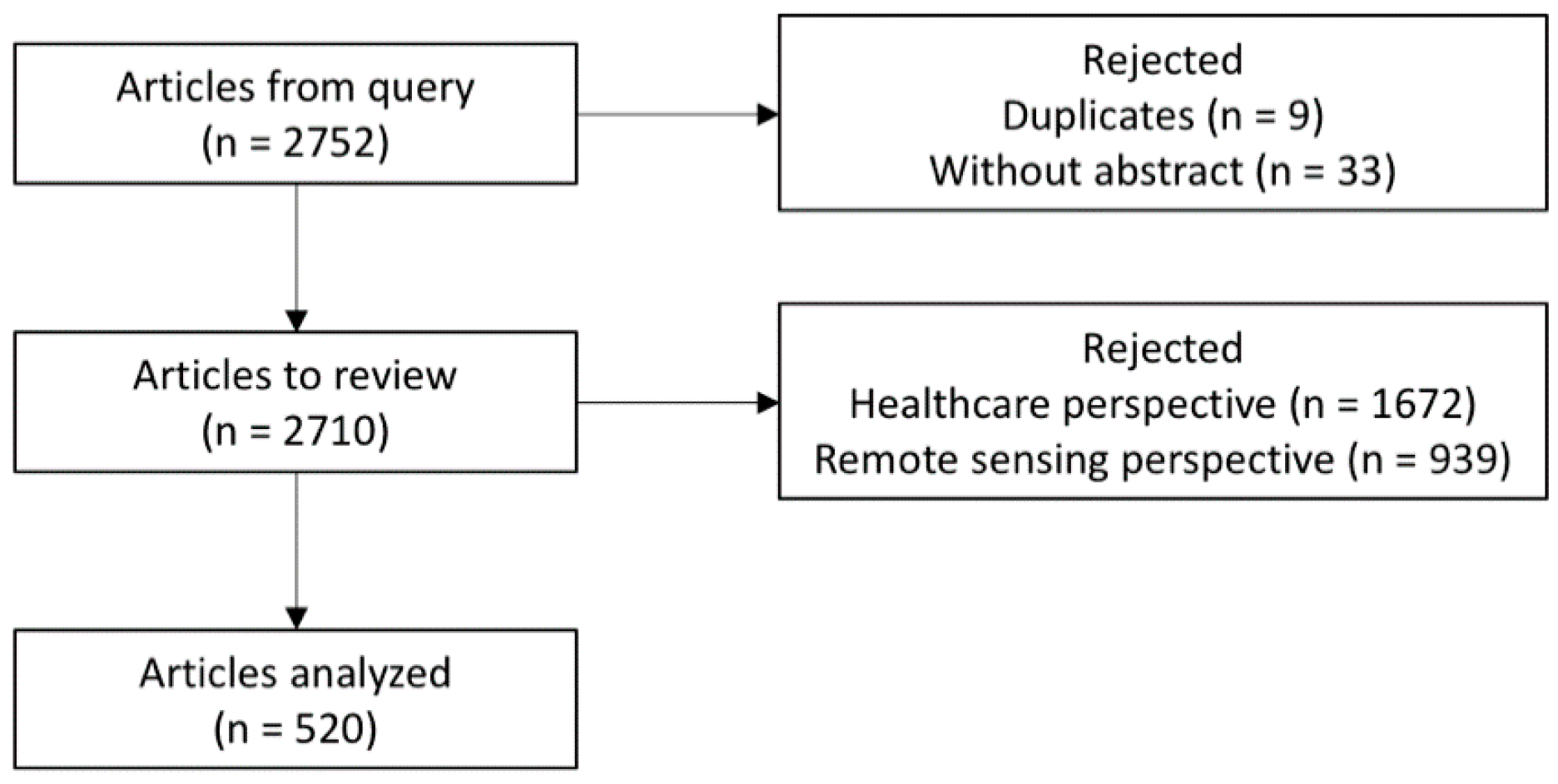
Figure 2.
Annual growth rate of publications in health and remote sensing, annual growth rate of all the publications indexed in Scopus and annual growth rate of publications indexed in Scopus in the medical area per year (2008–2016) compared to the reference year (2007).
Figure 2.
Annual growth rate of publications in health and remote sensing, annual growth rate of all the publications indexed in Scopus and annual growth rate of publications indexed in Scopus in the medical area per year (2008–2016) compared to the reference year (2007).
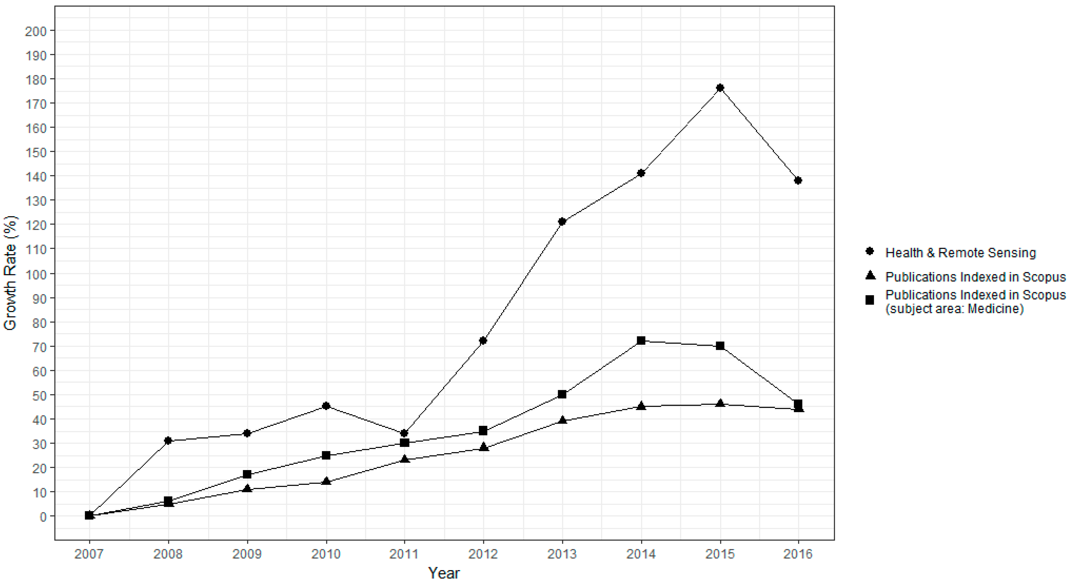
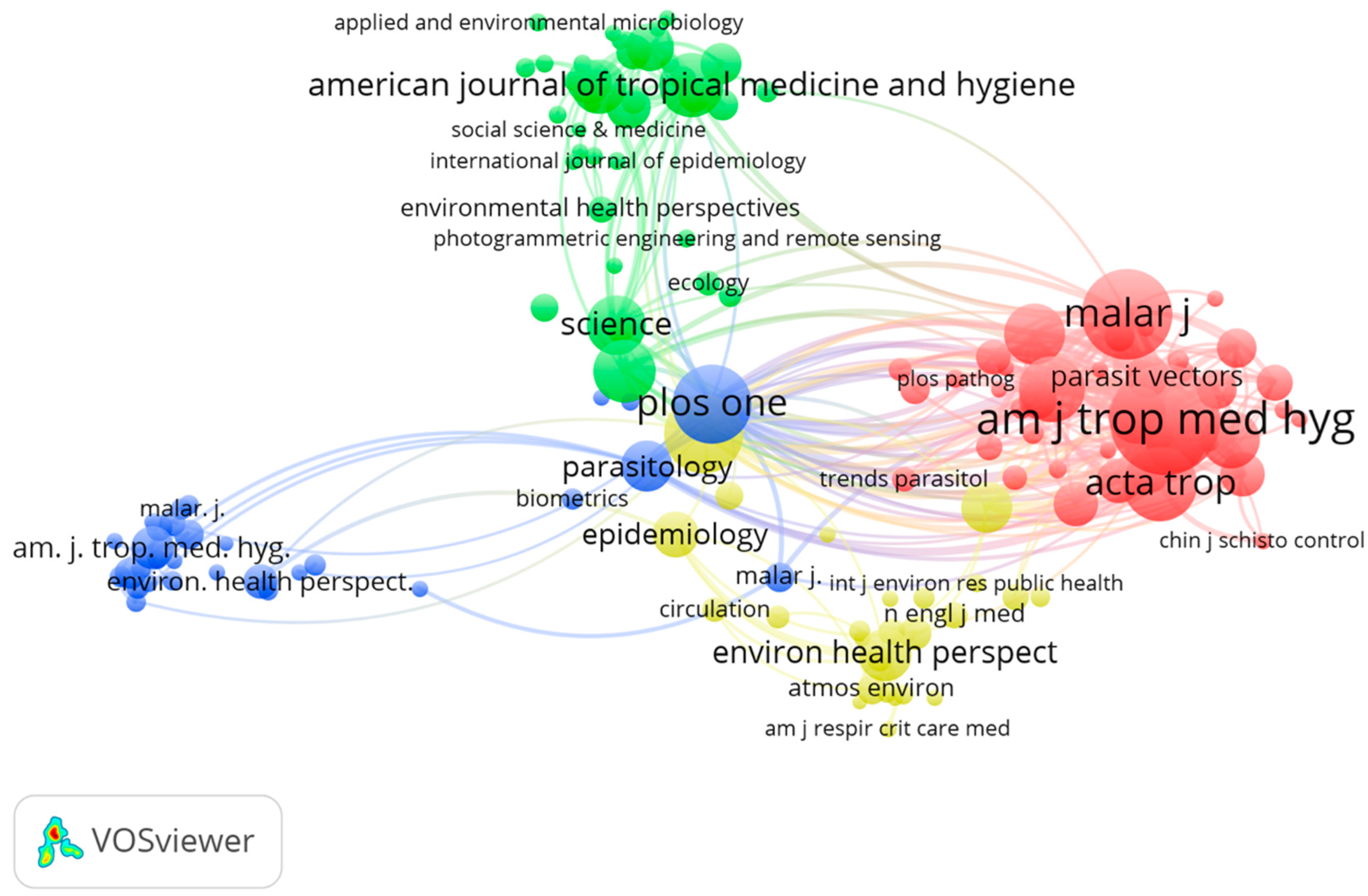
Figure 3.
Co-citations relations between sources. Each circle represents a different journal, with the larger circles having the highest number of citations in the field of remote sensing applied to human health. The lines reflect the link strength between the different sources. A minimum of 20 citations per source was considered, with 139 sources meeting this criterion.

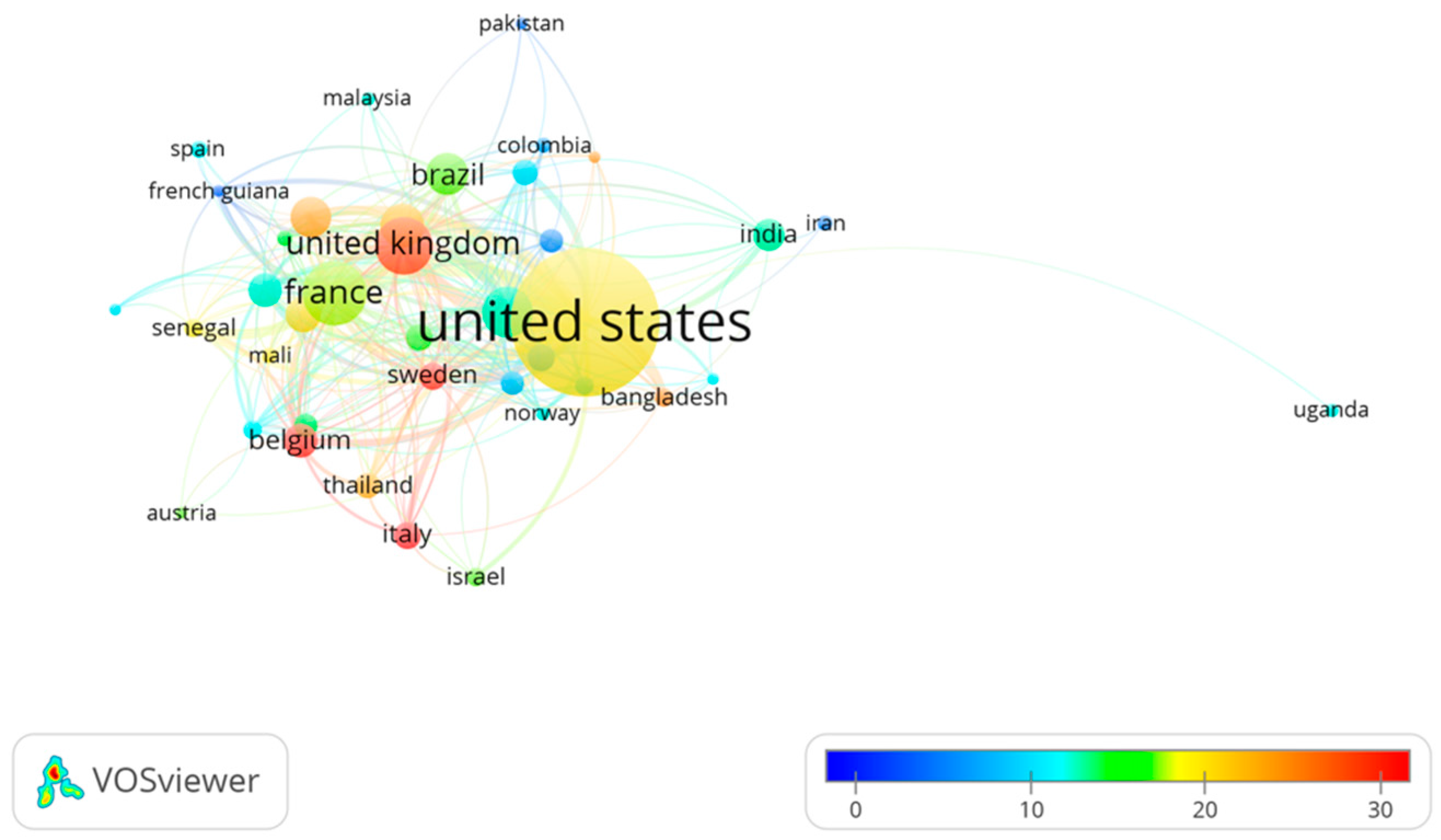
Figure 4.
Citation relationships between countries. The size of each circle is proportional to the number of published articles, the color represents the countries’ average citations and the lines reflect the citations between countries. Only countries with a minimum productivity of five articles were included.

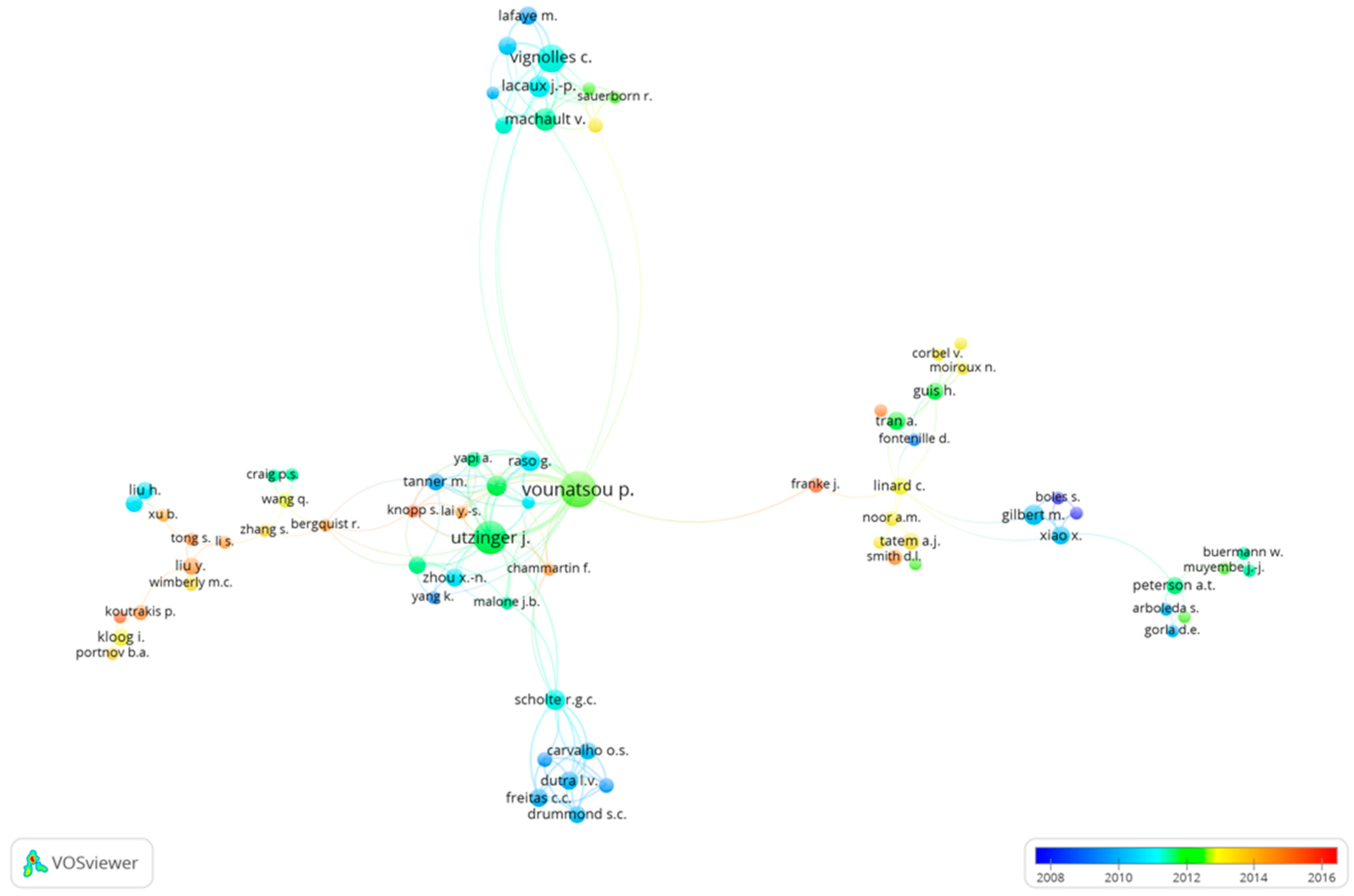
Figure 5.
Co-authorship relations between authors. Each author is represented by a circle, where closer circles represent authors with close research collaborations, the size and name of the circle represent the number of publications, and the color represents the average publication year. The selection was made with a minimum of three documents per author, with 162 authors selected. However, the representation depicts 72 authors that had connections among them.


Table 1.
Frequency of disease-specific keywords found either in Index or Author’s keywords.
| Keyword | Occurrences as Index or Author Keywords n (%) |
|---|---|
| Malaria | 142 (27.3) |
| Dengue | 34 (6.5) |
| Schistosomiasis | 24 (4.6) |
| Cholera | 16 (3.1) |
| Cardiovascular disease | 15 (2.9) |
| Asthma | 14 (2.7) |
| Schistosomiasis japonica | 10 (1.9) |
| Chagas disease | 9 (1.7) |
| Obesity | 6 (1.2) |
| Pregnancy | 2 (0.4) |
Table 2.
Yearly summary of publish articles in the field of remote sensing applied to human health. Articles—number of articles publish per year and percentage from the total of articles retrieved (520), ACLO—Articles cited at least once, ACLO %—percentage of articles cited at least once when compared to total annual publication, ACY—average citation per year.
| Year | Articles (%) | ACLO | ACLO % | ACY | Total-Citations | Median (Q1–Q3) of Citations |
|---|---|---|---|---|---|---|
| 2007 | 29 (5.6) | 28 | 96.6% | 95.8 | 1051 | 30.5 (17.5–52.5) |
| 2008 | 38 (7.3) | 37 | 97.4% | 138.7 | 1248 | 22.0 (9.5–39) |
| 2009 | 39 (7.5) | 36 | 92.3% | 144.3 | 1176 | 21.5 (10.5–38.5) |
| 2010 | 42 (8.1) | 42 | 100% | 117.4 | 823 | 15.5 (8–26) |
| 2011 | 39 (7.5) | 39 | 100% | 110.7 | 664 | 9.0 (8–22) |
| 2012 | 50 (9.6) | 49 | 98.0% | 192.4 | 990 | 11.0 (6.5–28) |
| 2013 | 64 (12.3) | 59 | 92.2% | 169.5 | 725 | 9.0 (5–14) |
| 2014 | 70 (13.5) | 66 | 94.3% | 209.0 | 633 | 7.0 (3–12) |
| 2015 | 80 (15.4) | 69 | 86.3% | 266.5 | 533 | 4.0 (2–7) |
| 2016 | 69 (13.3) | 47 | 68.1% | 191.0 | 191 | 3.0 (1–5) |
Table 3.
Top 10 most referenced publications by articles in the field of remote sensing applied to human health.
Table 3.
Top 10 most referenced publications by articles in the field of remote sensing applied to human health.
| References | Title | Number of Citations |
|---|---|---|
| Gilbert et al. (2008) | Mapping H5N1 highly pathogenic avian influenza risk in Southeast Asia | 196 |
| Kraemer et al. (2015) | The global distribution of the arbovirus vectors Aedes aegypti and Ae. Albopictus | 186 |
| Reid et al. (2009) | Mapping community determinants of heat vulnerability | 180 |
| De Magny et al. (2008) | Environmental signatures associated with cholera epidemics | 136 |
| Delfino et al. (2009) | The relationship of respiratory and cardiovascular hospital admissions to the southern California wildfires of 2003 | 116 |
| Vittor et al. (2009) | Linking deforestation to malaria in the Amazon: Characterization of the breeding habitat of the principal malaria vector, Anopheles darlingi | 114 |
| Bejon et al. (2010) | Stable and unstable malaria hotspots in longitudinal cohort studies in Kenya | 110 |
| Kloog et al. (2008) | Light at night co-distributes with incident breast but not lung cancer in the female population of Israel | 99 |
| Chan et al. (2008) | Increasing cardiopulmonary emergency visits by long-range transported Asian dust storms in Taiwan | 94 |
| Gilbert et al. (2007) | Avian influenza, domestic ducks and rice agriculture in Thailand | 93 |
Table 4.
Ranking of institutions and organizations with a minimum productivity of 10 publications in the field of remote sensing applied o health. Articles (%)—number of articles per institution and percentage from the total of articles retrieved (n = 520).
Table 4.
Ranking of institutions and organizations with a minimum productivity of 10 publications in the field of remote sensing applied o health. Articles (%)—number of articles per institution and percentage from the total of articles retrieved (n = 520).
| Institution | Articles (%) |
|---|---|
| Swiss Tropical and Public Health Institute, Switzerland | 31 (6.0) |
| University of Basel, Switzerland | 22 (4.2) |
| Johns Hopkins University, United States | 22 (4.2) |
| University of California, United States | 20 (3.8) |
| University of Florida, United States | 13 (2.5) |
| University of Oxford, United Kingdom | 13 (2.5) |
| National Institutes of Health, United States | 12 (2.3) |
| Emory University, United States | 12 (2.3) |
| Columbia University, United States | 11 (2.1) |
| University of Maryland, United States | 10 (1.9) |
| Kenya Medical Research Institute, Kenya | 10 (1.9) |
| Nagasaki University, Japan | 10 (1.9) |
| University of Miami, United States | 10 (1.9) |
Table 5.
Ranking of journals with a minimum productivity of 10 publications in the field of remote sensing applied o health. Articles (%)—number of articles per journal and percentage from the total of articles retrieved (n = 520).
Table 5.
Ranking of journals with a minimum productivity of 10 publications in the field of remote sensing applied o health. Articles (%)—number of articles per journal and percentage from the total of articles retrieved (n = 520).
| Journal | Articles (%) |
|---|---|
| Malaria Journal | 39 (7.5) |
| International Journal of Health Geographics | 34 (6.5) |
| PLoS ONE | 32 (6.2) |
| Geospatial Health | 31 (6.0) |
| PLoS Neglected Tropical Diseases | 17 (3.3) |
| American Journal of Tropical Medicine and Hygiene | 16 (3.1) |
| Acta Tropica | 13 (2.5) |
| Environmental Health Perspectives | 11 (2.1) |
| Parasites and Vectors | 11 (2.1) |
| Environmental Research | 10 (1.9) |
| Geospatial health | 10 (1.9) |
Table 6.
Top 10 active authors in the field of remote sensing applied to human health. SCR—Standard Competition Ranking, Articles (%)—number of authorships and percentage from the total of articles retrieved (n = 520), % of Articles from Total—percentage of articles retrieved by the total scientific production within the study period.
| Standard Competition Ranking (SCR) | Author | Articles (%) | Total Articles in Scopus within the Study Period | % of Articles from Total |
|---|---|---|---|---|
| 1st | Vounatsou P. | 22 (4.2) | 129 | 17.1 |
| 2nd | Utzinger J. | 19 (3.7) | 429 | 4.4 |
| 3rd | Vignolles C. | 13 (2.5) | 25 | 52.0 |
| 4th | Machault V. | 9 (1.7) | 20 | 45.0 |
| 5th | Kumar V. | 8 (1.5) | 84 | 9.5 |
| 5th | Lacaux J.-P. | 8 (1.5) | 25 | 32.0 |
| 5th | Martin R.V. | 8 (1.5) | 133 | 6.0 |
| 5th | Shields T. | 8 (1.5) | 36 | 22.2 |
| 5th | Moss W.J. | 8 (1.5) | 113 | 7.1 |
| 10th | Bhunia G.S. | 7 (1.3) | 19 | 36.8 |
| 10th | Gilbert M. | 7 (1.3) | 74 | 9.5 |
| 10th | Kesari S. | 7 (1.3) | 28 | 25.0 |
| 10th | Raso G. | 7 (1.3) | 57 | 12.3 |
| 10th | Scholte R.G.C. | 7 (1.3) | 18 | 38.9 |
| 10th | van Donkelaar A. | 7 (1.3) | 85 | 8.2 |
| 10th | Das P. | 7 (1.3) | 264 | 2.7 |
| 10th | N’Goran E.K. | 7 (1.3) | 109 | 6.4 |
© 2017 by the authors. Licensee MDPI, Basel, Switzerland. This article is an open access article distributed under the terms and conditions of the Creative Commons Attribution (CC BY) license (http://creativecommons.org/licenses/by/4.0/).
Share and Cite
MDPI and ACS Style
Viana, J.; Santos, J.V.; Neiva, R.M.; Souza, J.; Duarte, L.; Teodoro, A.C.; Freitas, A. Remote Sensing in Human Health: A 10-Year Bibliometric Analysis. Remote Sens. 2017, 9, 1225. https://doi.org/10.3390/rs9121225
AMA Style
Viana J, Santos JV, Neiva RM, Souza J, Duarte L, Teodoro AC, Freitas A. Remote Sensing in Human Health: A 10-Year Bibliometric Analysis. Remote Sensing. 2017; 9(12):1225. https://doi.org/10.3390/rs9121225
Chicago/Turabian StyleViana, João, João Vasco Santos, Rui Manuel Neiva, Júlio Souza, Lia Duarte, Ana Cláudia Teodoro, and Alberto Freitas. 2017. "Remote Sensing in Human Health: A 10-Year Bibliometric Analysis" Remote Sensing 9, no. 12: 1225. https://doi.org/10.3390/rs9121225
Note that from the first issue of 2016, this journal uses article numbers instead of page numbers. See further details here.