
Cropping Intensity in the Aral Sea Basin and Its Dependency from the Runoff Formation 2000–2012

 , ,
, ,
Abstract
:
1. Introduction
- To extract the regional irrigated cropland extent (iCE) in the ASB from annual MR-MODIS time series from 2000 to 2012 and to validate the result using multi-annual high-resolution (HR) Landsat-7 ETM+ covered reference sites;
- To use the same RS data sets and the iCE results for accurate mapping of cropland vegetation phenology (CVP) and cropping intensity (CI) in the ASB;
- To statistically evaluate the dependency of CI and the percentage of fallow cropland (PF) in the ASB from annual runoff formation in the upstream catchments of the Amu Darya and Syr Darya Rivers.
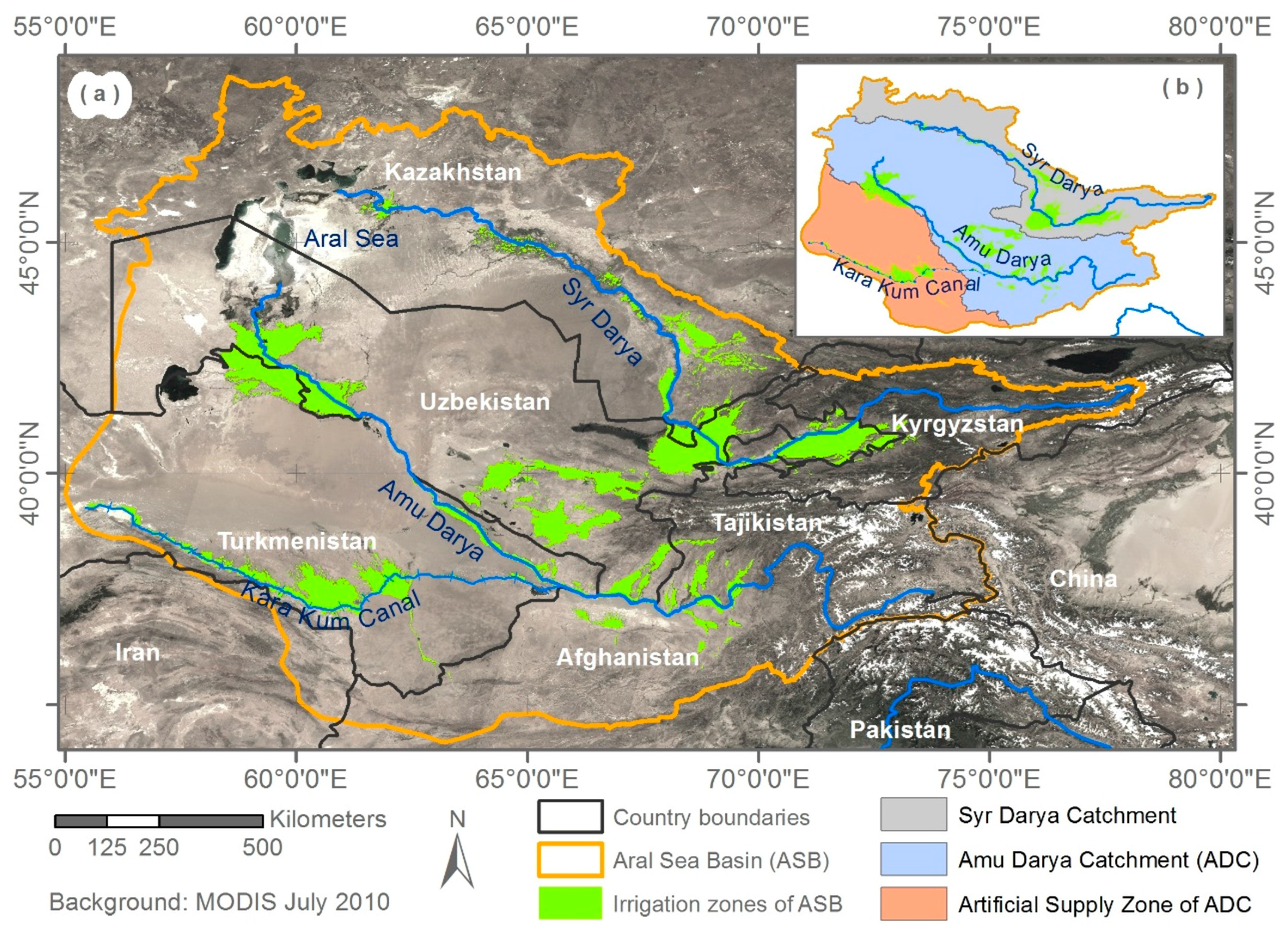
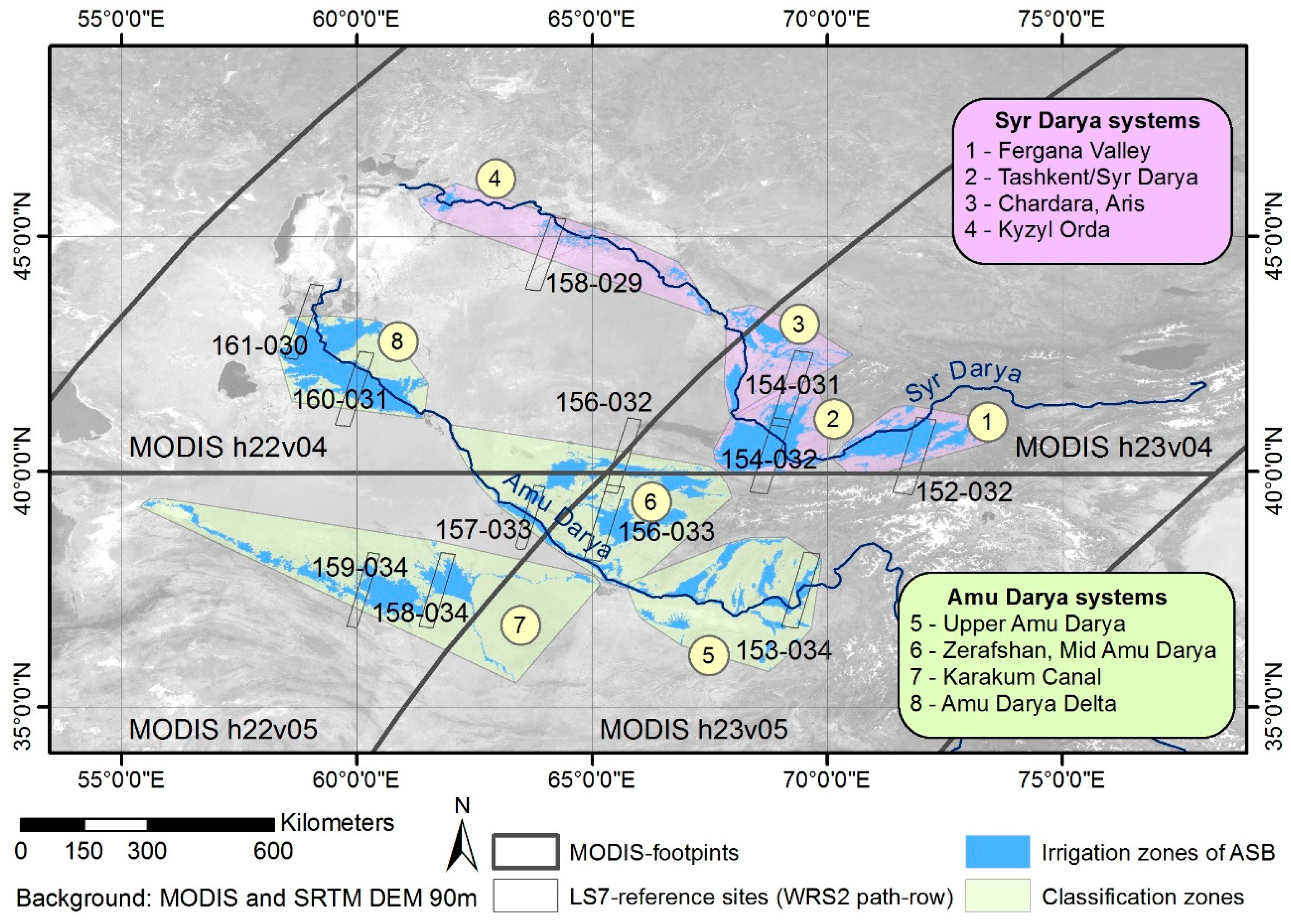
2. Study Region
3. Materials and Methods
3.1. Overall Mapping Approach
3.2. Database and Preprocessing
3.2.1. MODIS Data for Regional Mapping
3.2.2. Landsat Data for Training and Validation
3.2.3. Secondary Data
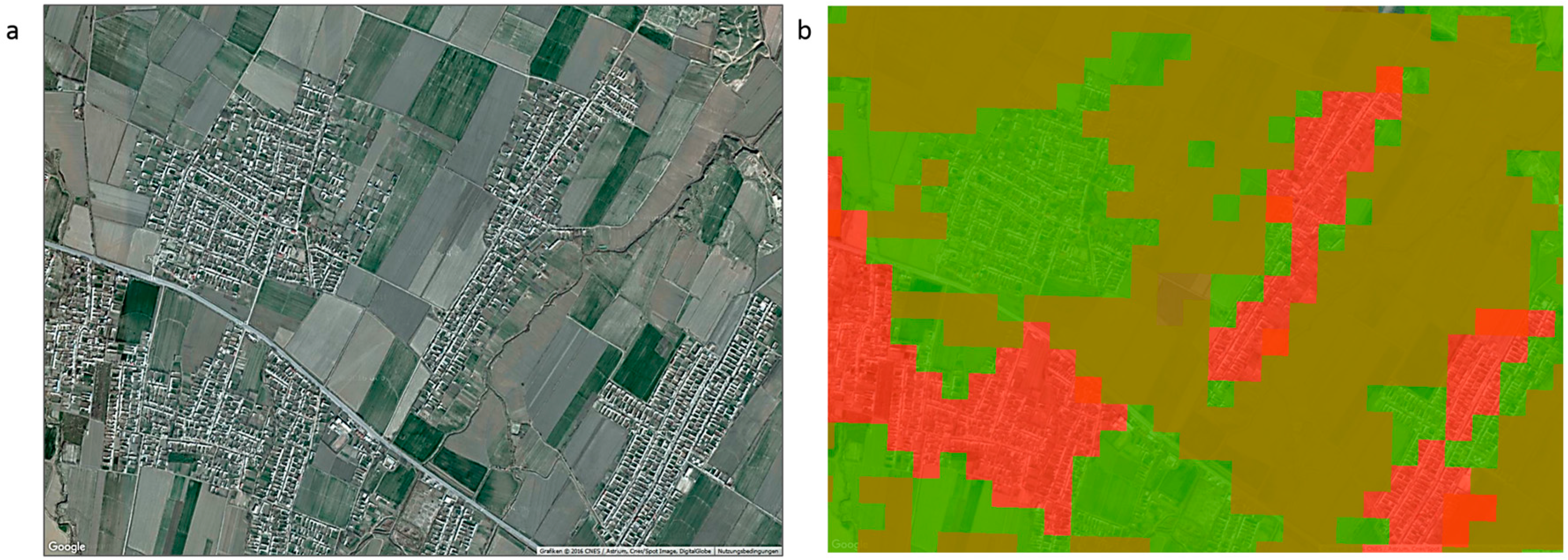
3.3. Derivation of the Irrigated Cropland Extent
3.3.1. Local Scale Reference Data (HR-iCE)
3.3.2. Regional Scale Mapping (MR-iCE)
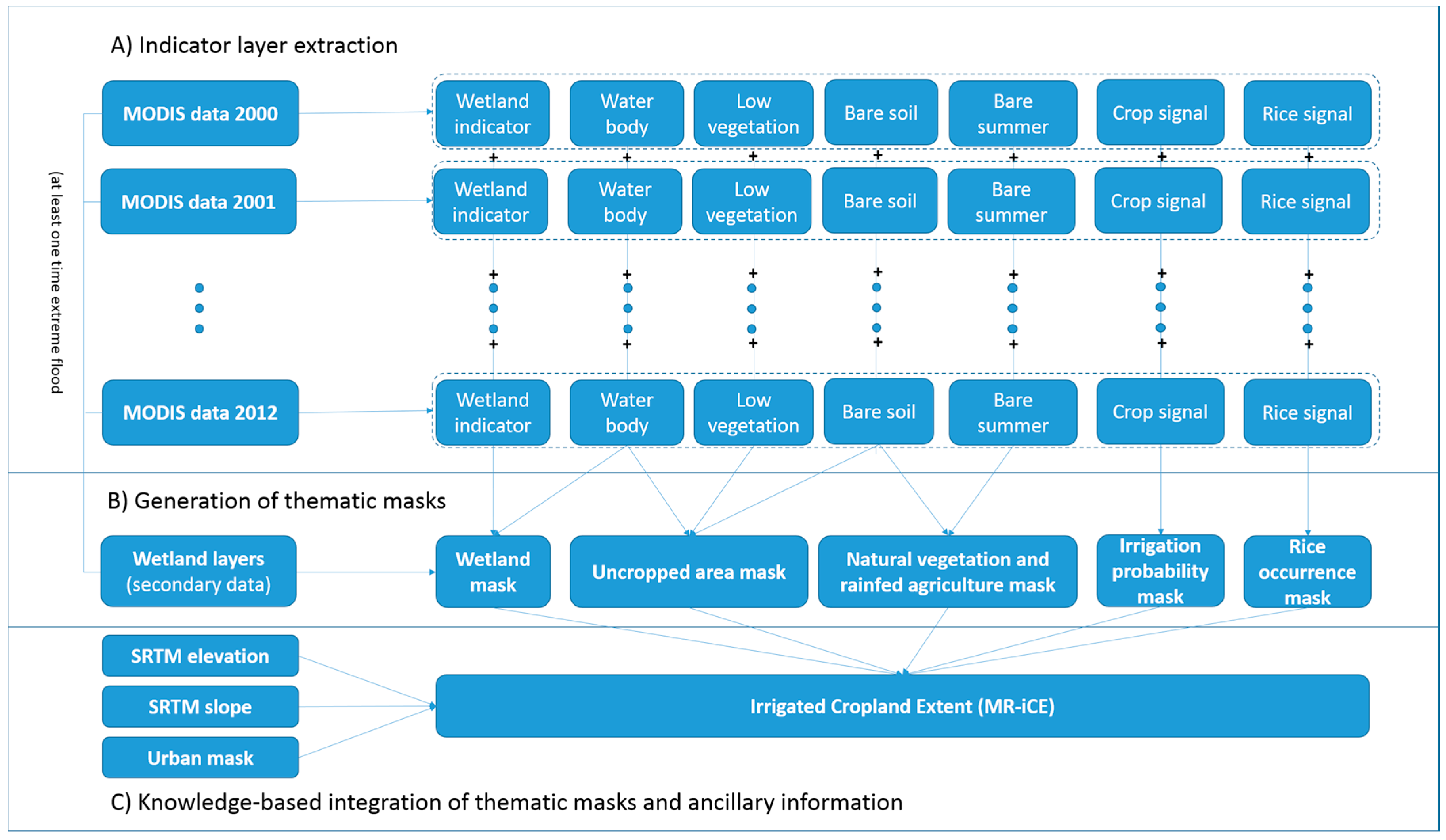
Extraction of Indicators
Generation of Thematic Masks
- If the total of wetland signals amounted to more than 10 years of the observation period (2000–2012), the respective pixel became part of the wetland mask, i.e., the raster value was set to 1. The wetland mask also included available secondary data (Section 3.2.3).
- A pixel was added to the uncropped area mask, if indication for either a water body, bare soil, or low vegetation was given throughout the observation period (2000–2012).
- If natural vegetation in the mountainous regions/winter wheat (spring peak & bare summer) or bare land were mapped in the indicator layers for the entire observation period, the pixel was included in the natural vegetation & rainfed agriculture mask.
- If the total of the crop signal layer (one high vegetation period indicating a crop signal in the annual MODIS-NDVI layerstack) amounted to 0, irrigation probability mask was also set to 0.
- In the KyzylOrda and the upper Amu Darya (Afghanistan, Tajikistan) regions, the discrimination between rice and wetland became possible by analyzing the 13 rice signal indicator layers (the rules are given in Table S1). All pixels where a rice signal occurred at least once within the observation period were assigned to the rice occurrence mask.
Knowledge-Based Data Integration
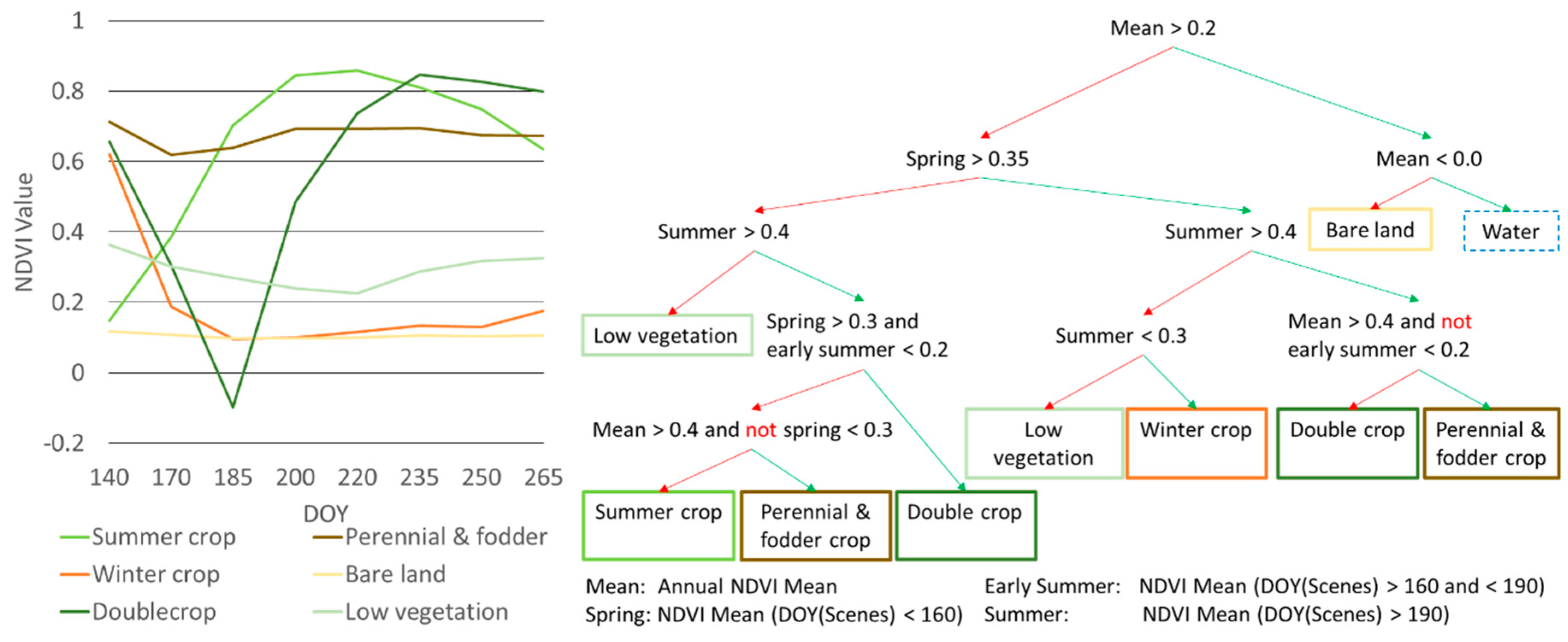
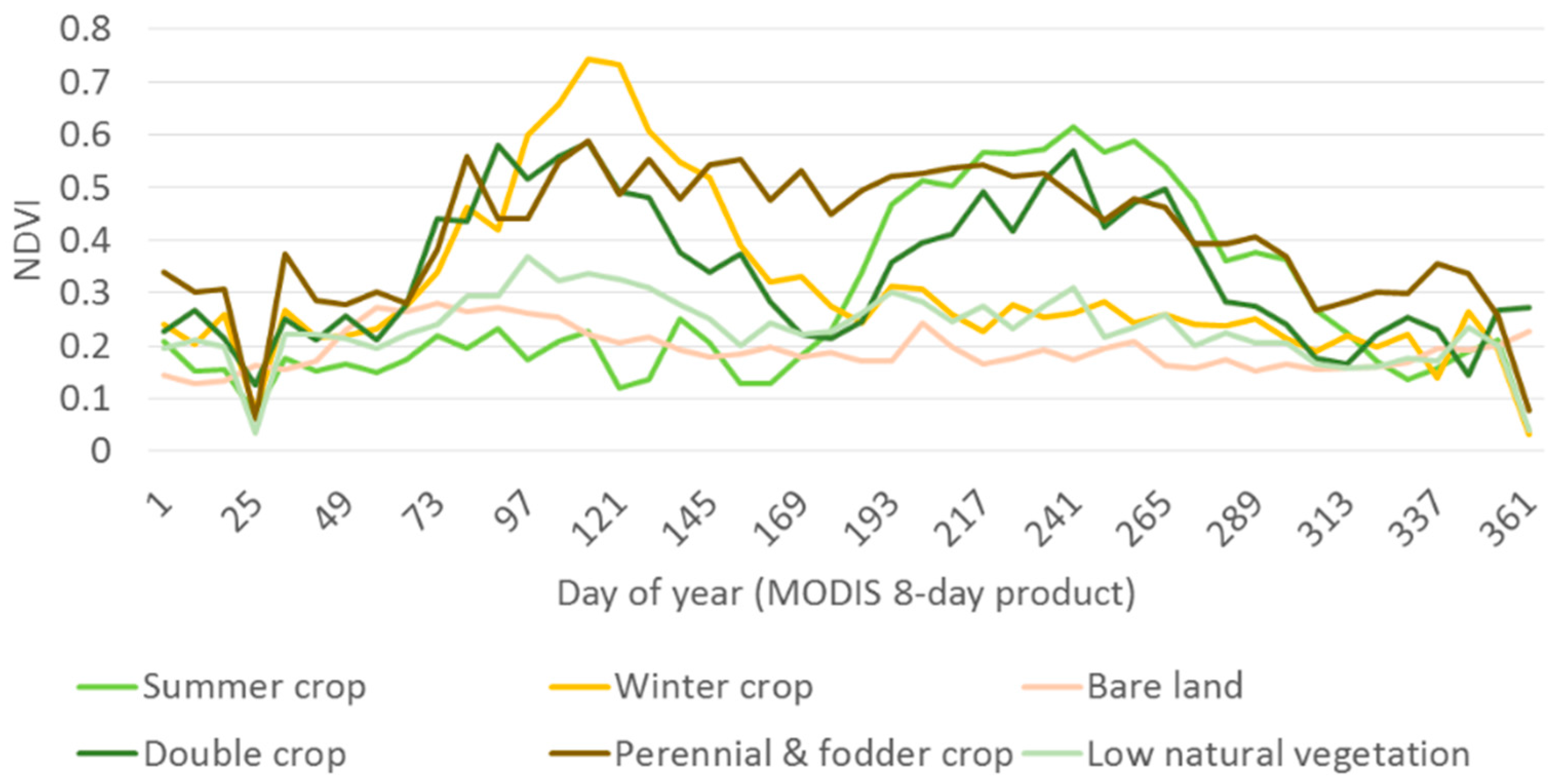
3.4. Derivation of the Cropping Intensity
3.4.1. Local Scale Reference Data (HR-CVP)
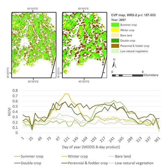
3.4.2. Regional Scale Mapping (MR-CVP)
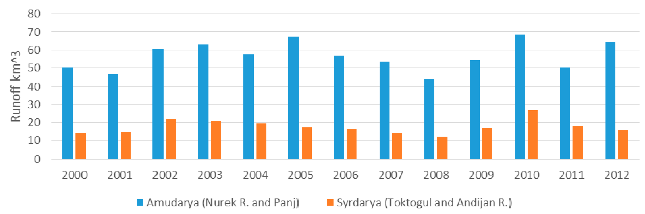
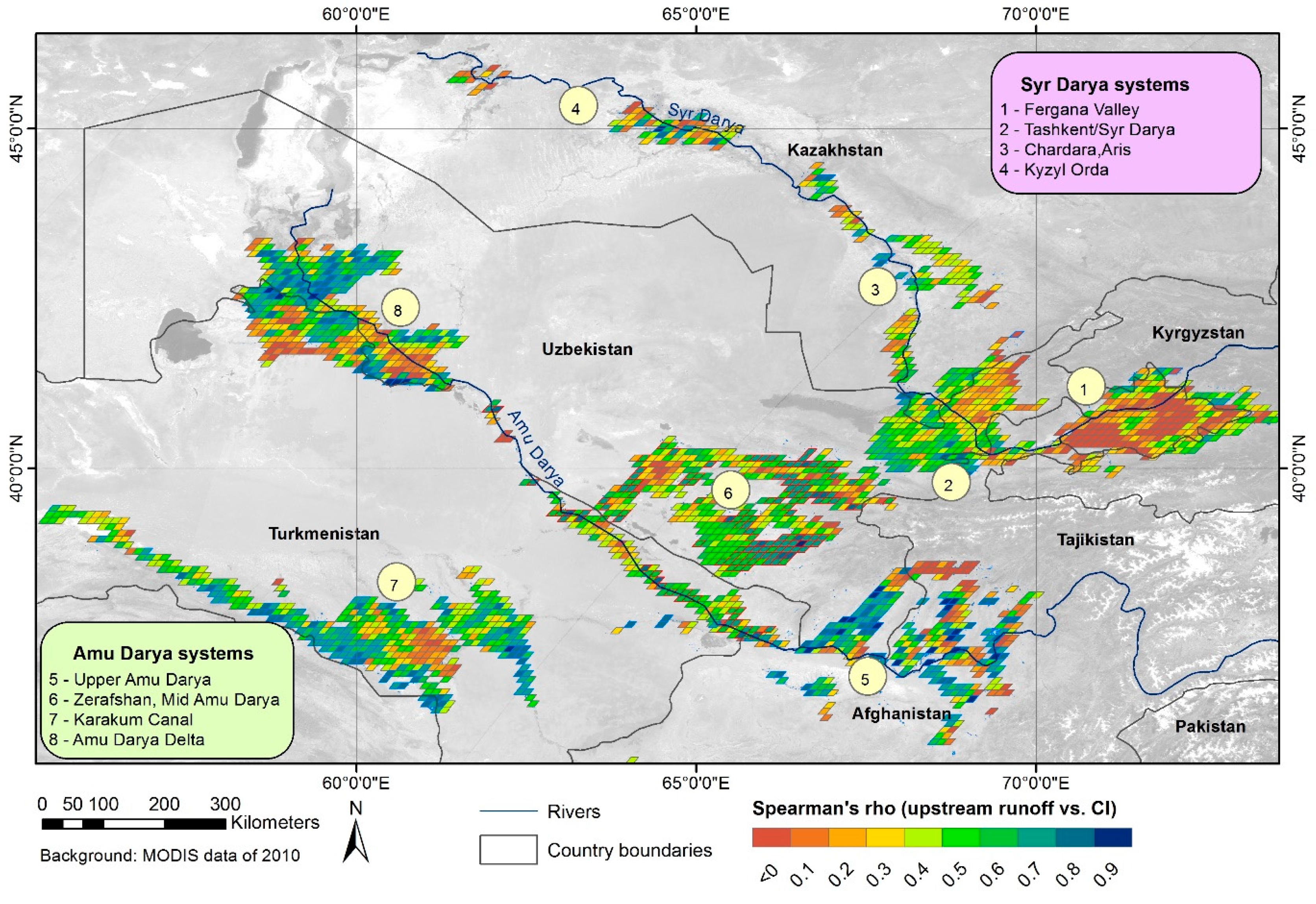
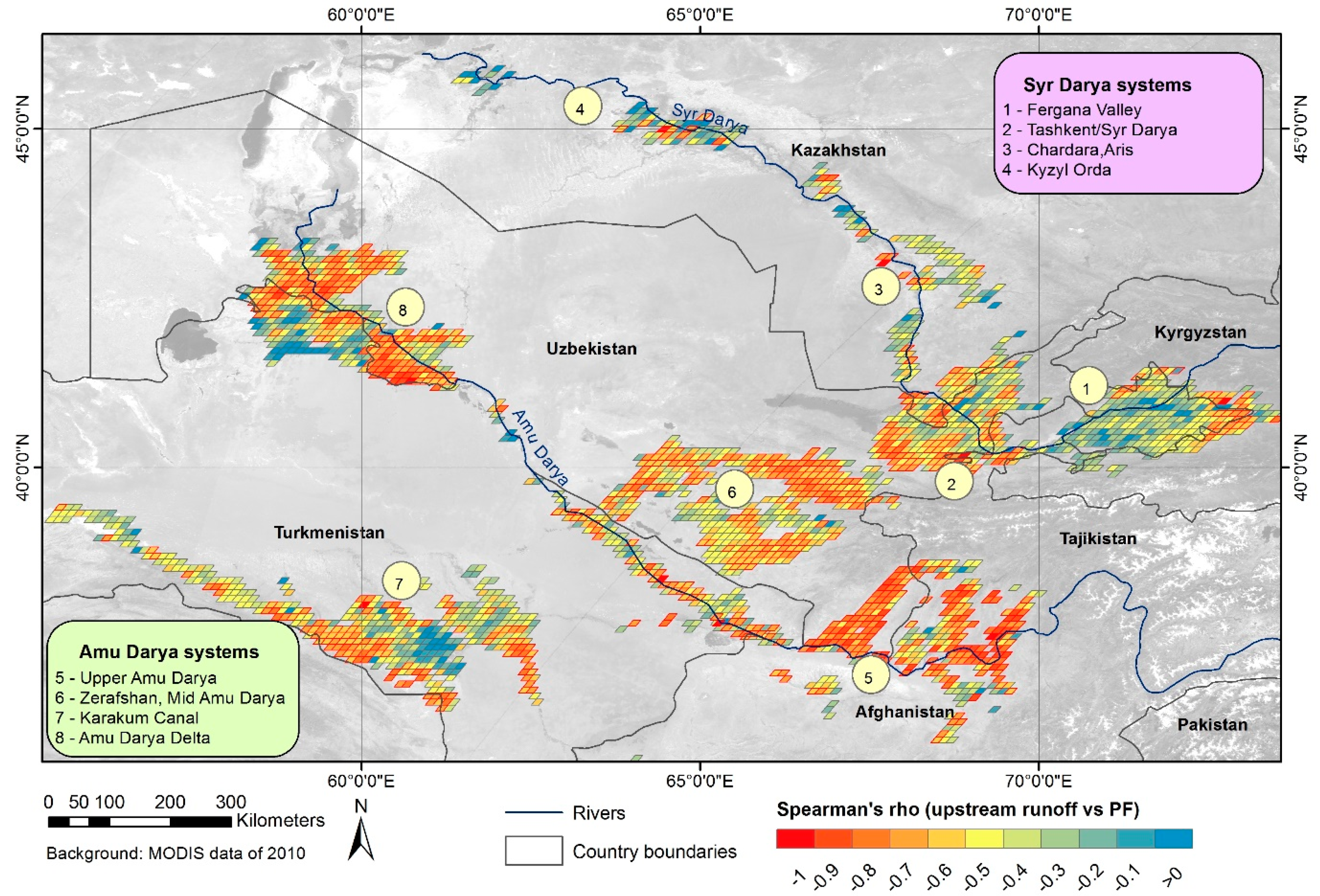
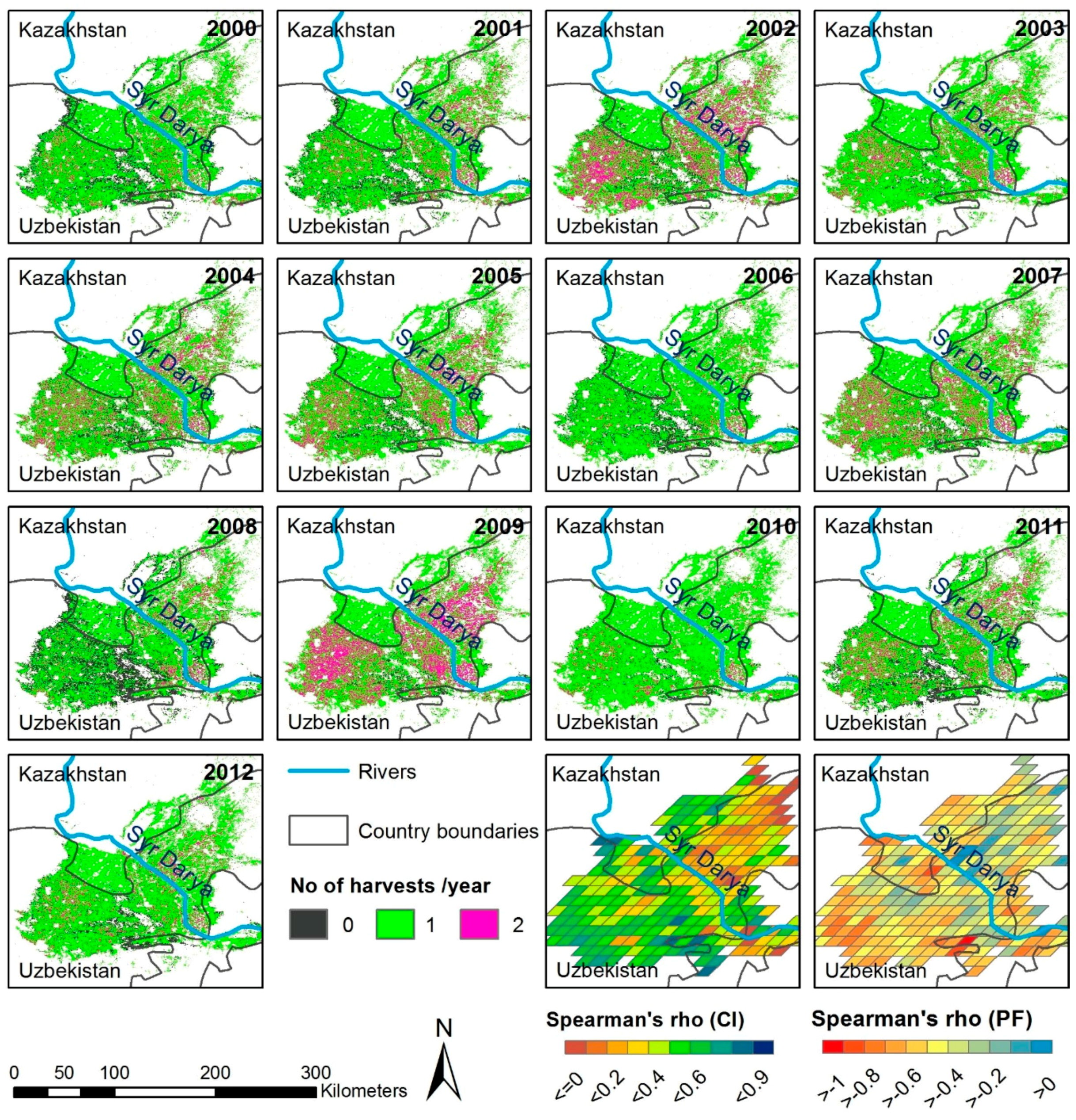
3.5. Cropping Intensity and Upstream Runoff Formation
4. Results
4.1. Validation of Classification
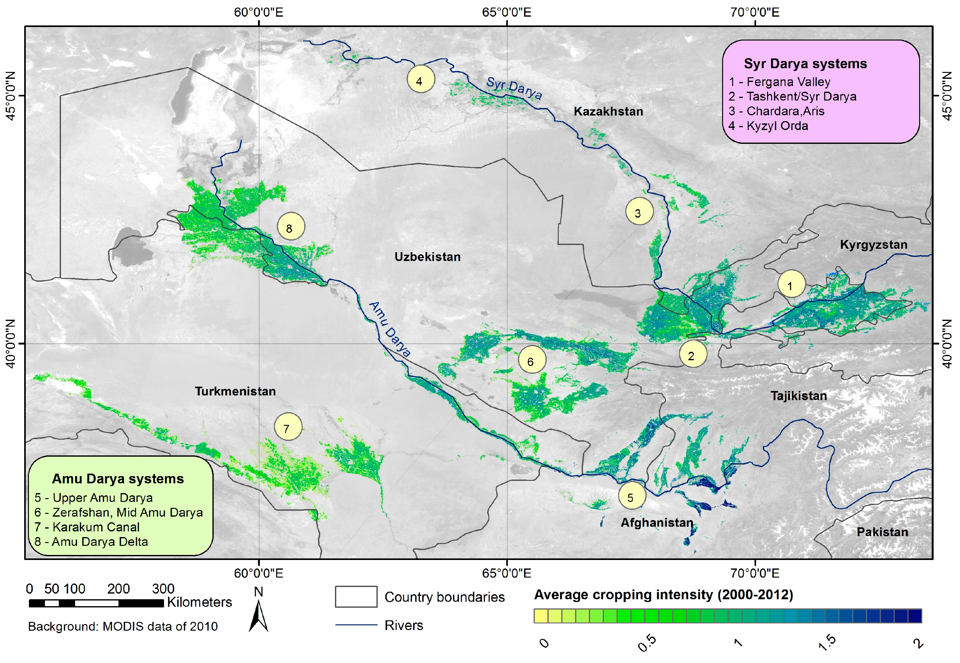
4.2. Irrigated Cropland Extent and Cropping Intensity in the ASB 2000–2012
4.3. Cropping Intensity and Upstream Runoff Formation
5. Discussion
5.1. Methodological Approach
5.2. Assessment of CI in the ASB (2000–2012)
6. Conclusions
Supplementary Materials
Acknowledgments
Author Contributions
Conflicts of Interest
Abbreviations
| ASB | Aral Sea Basin |
| AVHRR | Advanced Very High Resolution Radiometer |
| CAREWIB | Central Asia Regional Water Information Base Project |
| CART | Classification and Regression Tree |
| CAWa project | Central Asian Waters project |
| CE | Cropland Extent |
| CI | Cropping Intensity |
| CIGRID | Gridded Cropping Intensity (grids of 10 km × 10 km) |
| CVP | Cropland Vegetation Phenology |
| CZ | Classification Zone |
| DEM | Digital Elevation Model |
| DOY | Days of Year |
| ENVI | Environment for Visualizing Images |
| ETM+ | Enhanced Thematic Mapper Plus |
| FAO | Food and Agriculture Organization of the United Nations |
| GE | Google Earth |
| GIS | Geographic information system |
| HR | High Resolution |
| HR-CI | High-Resolution Cropping Intensity |
| HR-CVP | High-Resolution Cropl and Vegetation Phenology |
| HR-iCE | High-Resolution Irrigated Cropland Extent |
| iCE | Irrigated Cropland Extent |
| MODIS | Moderate Resolution Imaging Spectroradiometer |
| MR | Moderate Resolution |
| MR-CI | Moderate-Resolution Cropping Intensity |
| MR-CVP | Moderate-Resolution Cropland Vegetation Phenology |
| MR-iCE | Moderate-Resolution Irrigated Cropland Extent |
| NDVI | Normalized Differenced Vegetation Index |
| NIR | Near Infrared |
| OA | Overall Accuracy |
| OSM | Open Street Map |
| PF | Percentage of Fallow Cropland |
| RF | Random Forest |
| RS | Remote Sensing |
| SIC ICWC | Scientific-Information Center of the Interstate Coordination Water Commission of the Central Asia |
| SLC | Scan Line Corrector |
| SRTM | Shuttle Radar Topographic Mission |
| TiSeG | Time-Series Generator |
| TP | Transition Period |
| USGS | United States Geological Survey |
| WRS | World Reference System |
References
- Micklin, P. The aral sea disaster. Annu. Rev. Earth Planet. Sci. 2007, 35, 47–72. [Google Scholar] [CrossRef]
- Cai, X.; McKinney, D.C.; Rosegrant, M.W. Sustainability analysis for irrigation water management in the Aral Sea region. Agric. Syst. 2003, 76, 1043–1066. [Google Scholar] [CrossRef]
- Siegfried, T.; Bernauer, T.; Guiennet, R.; Sellars, S.; Robertson, A.W.; Mankin, J.; Bauer-Gottwein, P.; Yakovlev, A. Will climate change exacerbate water stress in Central Asia? Clim. Chang. 2012, 112, 881–899. [Google Scholar] [CrossRef]
- Bekchanov, M.; Ringler, C.; Bhaduri, A.; Jeuland, M. Optimizing irrigation efficiency improvements in the Aral Sea Basin. Water Resour. Econ. 2015, 13, 1–16. [Google Scholar] [CrossRef]
- Chemin, Y.; Platonov, A.; Ul-Hassan, M.; Abdullaev, I. Using remote sensing data for water depletion assessment at administrative and irrigation-system levels: Case study of the Ferghana Province of Uzbekistan. Agric. Water Manag. 2004, 64, 183–196. [Google Scholar] [CrossRef]
- Tischbein, B.; Manschadi, A.M.; Conrad, C.; Hornidge, A.-K.; Bhaduri, A.; Ul Hassan, M.; Lamers, J.P.A.; Awan, U.K.; Vlek, P.L.G. Adapting to water scarcity: Constraints and opportunities for improving irrigation management in Khorezm, Uzbekistan. Water Sci. Technol. Water Supply 2013, 13, 337–348. [Google Scholar] [CrossRef]
- Thevs, N.; Ovezmuradov, K.; Zanjani, L.V.; Zerbe, S. Water consumption of agriculture and natural ecosystems at the Amu Darya in Lebap Province, Turkmenistan. Environ. Earth Sci. 2014, 73, 731–741. [Google Scholar] [CrossRef]
- Bichsel, C. Liquid challenges: Contested water in central. Sustain. Dev. Law Policy 2011, 12, 24–30. [Google Scholar]
- Lioubimtseva, E.; Henebry, G.M. Climate and environmental change in arid Central Asia: Impacts, vulnerability, and adaptations. J. Arid Environ. 2009, 73, 963–977. [Google Scholar] [CrossRef]
- Mannig, B.; Müller, M.; Starke, E.; Merkenschlager, C.; Mao, W.; Zhi, X.; Podzun, R.; Jacob, D.; Paeth, H. Dynamical downscaling of climate change in Central Asia. Glob. Planet. Chang. 2013, 110, 26–39. [Google Scholar] [CrossRef]
- Schlüter, M.; Leslie, H.; Levin, S. Managing water-use trade-offs in a semi-arid river delta to sustain multiple ecosystem services: A modeling approach. Ecol. Res. 2009, 24, 491–503. [Google Scholar] [CrossRef]
- Qadir, M.; Noble, A.D.; Qureshi, A.S.; Gupta, R.K.; Yuldashev, T.; Karimov, A. Salt induced land and water degradation in the Aral Sea basin: A challenge to sustainable agriculture in Central Asia. Nat. Resour. Forum 2009, 33, 134–149. [Google Scholar] [CrossRef]
- Khamzina, A.; Lamers, J.P.A.; Vlek, P.L.G. Tree establishment under deficit irrigation on degraded agricultural land in the lower Amu Darya River region, Aral Sea Basin. For. Ecol. Manag. 2008, 255, 168–178. [Google Scholar] [CrossRef]
- Dubovyk, O.; Menz, G.; Khamzina, A. Land suitability assessment for afforestation with Eleagnus Angustifolia L. in degraded agricultural areas of the lower Amu Darya Basin. L. Degrad. Dev. 2014. [Google Scholar] [CrossRef]
- Lobell, D.B.; Bonfils, C.J.; Kueppers, L.M.; Snyder, M.A. Irrigation cooling effect on temperature and heat index extremes. Geophys. Res. Lett. 2008, 35, 1–5. [Google Scholar] [CrossRef]
- Sorooshian, S.; Li, J.; Hsu, K.L.; Gao, X. How significant is the impact of irrigation on the local hydroclimate in Californias Central Valley? Comparison of model results with ground and remote-sensing data. J. Geophys. Res. Atmos. 2011, 116, 1–11. [Google Scholar] [CrossRef]
- Wen, L.; Jin, J. Modelling and analysis of the impact of irrigation on local arid climate over northwest China. Hydrol. Process. 2012, 26, 445–453. [Google Scholar] [CrossRef]
- Douglas, E.M.; Beltrán-Przekurat, A.; Niyogi, D.; Pielke, R.A.; Vörösmarty, C.J. The impact of agricultural intensification and irrigation on land-atmosphere interactions and Indian monsoon precipitation—A mesoscale modeling perspective. Glob. Planet. Chang. 2009, 67, 117–128. [Google Scholar] [CrossRef]
- Siebert, S.; Portmann, F.T.; Döll, P. Global patterns of cropland use intensity. Remote Sens. 2010, 2, 1625–1643. [Google Scholar] [CrossRef]
- Monfreda, C.; Ramankutty, N.; Foley, J.A. Farming the planet: 2. Geographic distribution of crop areas, yields, physiological types, and net primary production in the year 2000. Glob. Biogeochem. Cycles 2008, 22, 1–19. [Google Scholar] [CrossRef]
- Portmann, F.T.; Siebert, S.; Döll, P. MIRCA2000—Global monthly irrigated and rainfed crop areas around the year 2000: A new high-resolution data set for agricultural and hydrological modeling. Glob. Biogeochem. Cycles 2010, 24, 1–24. [Google Scholar] [CrossRef]
- Conrad, C.; Loew, F.; Rudloff, M.; Schorcht, G. Assessing irrigated cropland dynamics in central Asia between 2000 and 2011 based on MODIS time series. Proc. SPIE 2012. [Google Scholar] [CrossRef]
- Gray, J.; Friedl, M.; Frolking, S.; Ramankutty, N.; Nelson, A.; Gumma, M.K. Mapping Asian cropping intensity with MODIS. IEEE J. Sel. Top. Appl. Earth Obs. Remote Sens. 2014, 7, 3373–3379. [Google Scholar] [CrossRef]
- Ganguly, S.; Friedl, M.A.; Tan, B.; Zhang, X.; Verma, M. Land surface phenology from MODIS: Characterization of the Collection 5 global land cover dynamics product. Remote Sens. Environ. 2010, 114, 1805–1816. [Google Scholar] [CrossRef]
- Ramankutty, N.; Evan, A.T.; Monfreda, C.; Foley, J.A. Farming the planet: 1. Geographic distribution of global agricultural lands in the year 2000. Glob. Biogeochem. Cycles 2008. [Google Scholar] [CrossRef]
- Waldner, F.; Fritz, S.; Di Gregorio, A.; Defourny, P. Mapping priorities to focus cropland mapping activities: Fitness assessment of existing global, regional and national cropland maps. Remote Sens. 2015, 7, 7959–7986. [Google Scholar] [CrossRef] [Green Version]
- Fritz, S.; See, L.; Mccallum, I.; You, L.; Bun, A.; Moltchanova, E.; Duerauer, M.; Albrecht, F.; Schill, C.; Perger, C.; et al. Mapping global cropland and field size. Glob. Chang. Biol. 2015, 21, 1980–1992. [Google Scholar] [CrossRef] [PubMed] [Green Version]
- Salmon, J.M.; Friedl, M.A.; Frolking, S.; Wisser, D.; Douglas, E.M. Global rain-fed, irrigated, and paddy croplands: A new high resolution map derived from remote sensing, crop inventories and climate data. Int. J. Appl. Earth Obs. Geoinf. 2015, 38, 321–334. [Google Scholar] [CrossRef]
- Thenkabail, P.S.; Biradar, C.M.; Turral, H.; Noojipady, P.; Li, Y.J.; Vithanage, J.; Dheeravath, V.; Velpuri, M.; Schull, M.; Cai, X.; et al. An Irrigated Area Map of the World (1999) Derived from Remote Sensing; International Water Management Institute: Colomobo, Sri Lanka, 2006. [Google Scholar]
- Thenkabail, P.S.; Biradar, C.M.; Noojipady, P.; Dheeravath, V.; Li, Y.; Velpuri, M.; Gumma, M.; Gangalakunta, O.R.P.; Turral, H.; Cai, X.; et al. Global irrigated area map (GIAM), derived from remote sensing, for the end of the last millennium. Int. J. Remote Sens. 2009, 30, 3679–3733. [Google Scholar] [CrossRef]
- Löw, F.; Fliemann, E.; Abdullaev, I. Mapping abandoned agricultural land in Kyzyl-Orda, Kazakhstan using satellite remote sensing. Appl. Geogr. 2015, 62, 377–390. [Google Scholar] [CrossRef]
- Dubovyk, O.; Menz, G.; Conrad, C.; Kan, E.; Machwitz, M.; Khamzina, A. Spatio-temporal analyses of cropland degradation in the irrigated lowlands of Uzbekistan using remote-sensing and logistic regression modeling. Environ. Monit. Assess. 2013, 185, 4775–4790. [Google Scholar] [CrossRef] [PubMed]
- Klein, I.; Gessner, U.; Kuenzer, C. Regional land cover mapping and change detection in Central Asia using MODIS time-series. Appl. Geogr. 2012, 35, 219–234. [Google Scholar] [CrossRef]
- Thenkabail, P.S.; Wu, Z. An automated cropland classification algorithm (ACCA) for Tajikistan by combining landsat, MODIS, and secondary data. Remote Sens. 2012, 4, 2890–2918. [Google Scholar] [CrossRef]
- Edlinger, J.; Conrad, C.; Lamers, J. P. A.; Khasankhanova, G.; Koellner, T. Reconstructing the spatio-temporal development of irrigation systems in Uzbekistan using landsat time series. Remote Sens. 2012, 4, 3972–3994. [Google Scholar] [CrossRef]
- Pervez, S.; Budde, M.; Rowland, J. Remote sensing of environment mapping irrigated areas in Afghanistan over the past decade using MODIS NDVI. Remote Sens. Environ. 2014, 149, 155–165. [Google Scholar] [CrossRef]
- Löw, F.; Duveiller, G. Defining the spatial resolution requirements for crop identification using optical remote sensing. Remote Sens. 2014, 6, 9034–9063. [Google Scholar] [CrossRef]
- Ozdogan, M.; Yang, Y.; Allez, G.; Cervantes, C. Remote sensing of irrigated agriculture: Opportunities and challenges. Remote Sens. 2010, 2, 2274–2304. [Google Scholar] [CrossRef]
- Gu, Y.; Brown, J.F.; Miura, T.; van Leeuwen, W.J.D.; Reed, B.C. Phenological classification of the United States: A geographic framework for extending multi-sensor time-series data. Remote Sens. 2010, 2, 526–544. [Google Scholar] [CrossRef]
- Wardlow, B.D.; Egbert, S.L. Large-area crop mapping using time-series MODIS 250 m NDVI data: An assessment for the US Central Great Plains. Remote Sens. Environ. 2008, 112, 1096–1116. [Google Scholar] [CrossRef]
- Xiao, X.M.; Boles, S.; Liu, J.Y.; Zhuang, D.F.; Frolking, S.; Li, C.S.; Salas, W.; Moore, B. Mapping paddy rice agriculture in southern China using multi-temporal MODIS images. Remote Sens. Environ. 2005, 95, 480–492. [Google Scholar] [CrossRef]
- Biradar, C.M.; Xiao, X. Quantifying the area and spatial distribution of double- and triple-cropping croplands in India with multi-temporal MODIS imagery in 2005. Int. J. Remote Sens. 2011, 32, 367–386. [Google Scholar] [CrossRef]
- Jain, M.; Mondal, P.; DeFries, R.S.; Small, C.; Galford, G.L. Mapping cropping intensity of smallholder farms: A comparison of methods using multiple sensors. Remote Sens. Environ. 2013, 134, 210–223. [Google Scholar] [CrossRef]
- Liu, J.; Zhu, W.; Cui, X. A Shape-matching Cropping Index (CI) mapping method to determine agricultural cropland intensities in China using MODIS time-series data. Photogramm. Eng. Remote Sens. 2012, 78, 829–837. [Google Scholar] [CrossRef]
- Ozdogan, M.; Gutman, G. A new methodology to map irrigated areas using multi-temporal MODIS and ancillary data: An application example in the continental US. Remote Sens. Environ. 2008, 112, 3520–3537. [Google Scholar] [CrossRef]
- Dukhovny, V.A.; de Schutter, J.L.G. Water in Central Asia: Past, Present and Future; CRC Press/Balkema, Taylor & Francis Group: London, UK, 2011. [Google Scholar]
- Zonn, I.S. Karakum Canal: Artificial river in a desert. In The Turkmen Lake Altyn Asyr and Water Resources in Turkmenistan. Volume 28 of the Series The Handbook of Environmental Chemistry; Zonn, I.S., Kostianoy, A.G., Eds.; Springer: Berlin, Germany; Heidelberg, Germany, 2014; pp. 95–106. [Google Scholar]
- Kienzler, K.M.; Lamers, J.P.A.; McDonald, A.; Mirzabaev, A.; Ibragimov, N.; Egamberdiev, O.; Ruzibaev, E.; Akramkhanov, A. Conservation agriculture in Central Asia-What do we know and where do we go from here? Field Crop. Res. 2012, 132, 95–105. [Google Scholar] [CrossRef]
- Gupta, R.; Kienzler, K.; Martius, C.; Mirzabaev, A.; Oweis, T.; de Pauw, E.; Qadir, M.; Shideed, K.; Sommer, R.; Thomas, R.; et al. Research Prospectus: A Vision for Sustainable Land Management Research in Central Asia. ICARDA Central Asia and Caucasus Program; Sustainable Agriculture in Central Asia and the Caucasus Series No. 1; CGIAR-PFU: Tashkent, Uzbekistan, 2009. [Google Scholar]
- Reddy, J.M.; Muhammedjanov, S.; Jumaboev, K.; Eshmuratov, D. Analysis of cotton water productivity in Fergana Valley of Central Asia. Agric. Sci. 2012, 3, 822–834. [Google Scholar]
- Food and Agriculture Organization (FAO). Irrigation in Central Asia in Figures—AQUASTAT Survey—2012; FAO: Rome, Italy, 2012. [Google Scholar]
- Löw, F.; Knöfel, P.; Conrad, C. Analysis of uncertainty in multi-temporal object-based classification. ISPRS J. Photogramm. Remote Sens. 2015, 105, 91–106. [Google Scholar] [CrossRef]
- Tucker, C.J. Red and photographic infrared linear combinations for monitoring vegetation. Remote Sens. Environ. 1979, 8, 127–150. [Google Scholar] [CrossRef]
- Vermote, E.F.; El Saleous, N.Z.; Justice, C.O. Atmospheric correction of MODIS data in the visible to middle infrared: First results. Remote Sens. Environ. 2002, 83, 97–111. [Google Scholar] [CrossRef]
- Colditz, R.R.; Conrad, C.; Wehrmann, T.; Schmidt, M.; Dech, S. TiSeG: A flexible software tool for time-series generation of MODIS data utilizing the quality assessment science data set. IEEE Trans. Geosci. Remote Sens. 2008, 46, 3296–3308. [Google Scholar] [CrossRef]
- Vermote, E.F.; Kotchenova, S.Y.; Ray, J.P. MODIS Surface Reflectance User’s Guide; NASA GSFC Terrestrial Information Systems Laboratory: Greenbelt, MD, USA, 2011. [Google Scholar]
- Wolfe, R.E.; Roy, D.P.; Vermote, E. MODIS land data storage, gridding, and compositing methodology: Level 2 grid. IEEE Trans. Geosci. Remote Sens. 1998, 36, 1324–1338. [Google Scholar] [CrossRef]
- Conrad, C.; Dech, S.W.; Hafeez, M.; Lamers, J.; Martius, C.; Strunz, G. Mapping and assessing water use in a Central Asian irrigation system by utilizing MODIS remote sensing products. Irrig. Drain. Syst. 2007, 21, 197–218. [Google Scholar] [CrossRef]
- Chen, J.; Zhu, X.; Vogelmann, J.E.; Gao, F.; Jin, S. A simple and effective method for filling gaps in Landsat ETM+ SLC-off images. Remote Sens. Environ. 2011, 115, 1053–1064. [Google Scholar] [CrossRef]
- Roy, D.P.; Wulder, M.A.; Loveland, T.R.; Woodcock, C.E.; Allen, R.G.; Anderson, M.C.; Helder, D.; Irons, J.R.; Johnson, D.M.; Kennedy, R.; et al. Landsat-8: Science and product vision for terrestrial global change research. Remote Sens. Environ. 2014, 145, 154–172. [Google Scholar] [CrossRef]
- Löw, F.; Navratil, P.; Kotte, K.; Schöler, H.F.; Bubenzer, O. Remote-sensing-based analysis of landscape change in the desiccated seabed of the Aral Sea—A potential tool for assessing the hazard degree of dust and salt storms. Environ. Monit. Assess. 2013, 185, 8303–8319. [Google Scholar] [CrossRef] [PubMed]
- Jarvis, A.; Reuter, H.I.; Nelson, A.; Guevara, E. Hole-filled SRTM for the Globe Version 4, Available from the CGIAR-CSI SRTM 90 m Database; CGIAR-CSI: Washington, DC, USA, 2008. [Google Scholar]
- SIC-ICWC Regional Information System on Water and Land Resources in the Aral Sea basin (CAREWIB). Available online: http://www.cawater-info.net (accessed on 23 July 2016).
- Congalton, R. A review of assessing the accuracy of classifications of remotely sensed data. Remote Sens. Environ. 1991, 37, 35–46. [Google Scholar] [CrossRef]
- Conrad, C.; Colditz, R.R.; Dech, S.; Klein, D.; Vlek, P.L.G. Temporal segmentation of MODIS time series for improving crop classification in Central Asian irrigation systems. Int. J. Remote Sens. 2011, 32, 8763–8778. [Google Scholar] [CrossRef]
- Conrad, C.; Dech, S.; Dubovyk, O.; Fritsch, S.; Klein, D.; Löw, F.; Schorcht, G.; Zeidler, J. Derivation of temporal windows for accurate crop discrimination in heterogeneous croplands of Uzbekistan using multitemporal RapidEye images. Comput. Electron. Agric. 2014, 103, 63–74. [Google Scholar] [CrossRef]
- Breiman, L. Random forests. Mach. Learn. 2001, 45, 5–32. [Google Scholar] [CrossRef]
- Rodriguez-Galiano, V.F.; Chica-Olmo, M.; Abarca-Hernandez, F.; Atkinson, P.M.; Jeganathan, C. Random forest classification of Mediterranean land cover using multi-seasonal imagery and multi-seasonal texture. Remote Sens. Environ. 2012, 121, 93–107. [Google Scholar] [CrossRef]
- Löw, F.; Conrad, C.; Michel, U. Decision fusion and non-parametric classifiers for land use mapping using multi-temporal RapidEye data. ISPRS J. Photogramm. Remote Sens. 2015, 108, 191–204. [Google Scholar] [CrossRef]
- Liaw, A.; Wiener, M. Classification and regression by random forest. R News 2002, 2, 18–22. [Google Scholar]
- Team, R.C. R: A Language and Environment for Statistical Computing; R Foundation for Statistical Computing: Vienna, Austria, 2015. [Google Scholar]
- Gumma, M.K.; Thenkabail, P.S.; Maunahan, A.; Islam, S.; Nelson, A. Mapping seasonal rice cropland extent and area in the high cropping intensity environment of Bangladesh using MODIS 500 m data for the year 2010. ISPRS J. Photogramm. Remote Sens. 2014, 91, 98–113. [Google Scholar] [CrossRef]
- Thenkabail, P.S.; Gangadhararao, P.; Biggs, T.W.; Krishna, M.; Turral, H. Spectral matching techniques to determine historical land-use/land-cover ( LULC ) and irrigated areas using time-series 0.1-degree AVHRR pathfinder datasets. Photogramm. Eng. Remote Sens. 2007, 73, 1029–1040. [Google Scholar]
- Lobell, D.B.; Asner, G.P. Cropland distributions from temporal unmixing of MODIS data. Remote Sens. Environ. 2004, 93, 412–422. [Google Scholar]
- Velpuri, N.M.; Thenkabail, P.S.; Gumma, M.K.; Biradar, C.; Dheeravath, V.; Noojipady, P.; Yuanjie, L. Influence of resolution in irrigated area mapping and area estimation. Photogramm. Eng. Remote Sens. 2009, 75, 1383–1395. [Google Scholar] [CrossRef]
- Pittman, K.; Hansen, M.C.; Becker-Reshef, I.; Potapov, P.V.; Justice, C.O. Estimating global cropland extent with multi-year MODIS data. Remote Sens. 2010, 2, 1844–1863. [Google Scholar] [CrossRef]
- SIC-ICWC Land Resources of the Aral Sea Basin. Available online: http://www.cawater-info.net/aral/land_e.htm (accessed on 15 June 2016).
- Rakhmatullaev, S.; Huneau, F.; Le Coustumer, P.; Motelica-Heino, M.; Bakiev, M. Facts and perspectives of water reservoirs in central Asia: A special focus on Uzbekistan. Water 2010, 2, 307–320. [Google Scholar] [CrossRef]
- O’Hara, S.L. Irrigation and land degradation: Implications for agriculture in Turkmenistan, central Asia. J. Arid Environ. 1997, 37, 165–179. [Google Scholar] [CrossRef]
- Abdullaev, I.; Rakhmatullaev, S. Transformation of water management in Central Asia: From State-centric, hydraulic mission to socio-political control. Environ. Earth Sci. 2013, 73, 849–861. [Google Scholar] [CrossRef]
- Wegerich, K.; Van Rooijen, D.; Soliev, I.; Mukhamedova, N. Water security in the Syr Darya basin. Water 2015, 7, 4657–4684. [Google Scholar] [CrossRef]


| CZs | Path-Row | Number of Available Scenes | ||||||||||||
|---|---|---|---|---|---|---|---|---|---|---|---|---|---|---|
| 2000 | 2001 | 2002 | 2003 | 2004 | 2005 | 2006 | 2007 | 2008 | 2009 | 2010 | 2011 | 2012 | ||
| 1 | 152-32 | 3 (1) | 5 | 6 | 5 (4) | 11 | 12 | 11 | 11 | 11 | 7 (1) | 4 (2) | 6 | 8 |
| 5 | 153-34 | 6 | 4 | 4 | 2 (1) | 6 | 6 | 9 | 10 | 7 | 6 | 3 | 8 | 7 |
| 3,2 | 154-31 | 3 | 3 (1) | 3 (1) | 2 (2) | 8 | 6 | 6 | 5 | 6 (1) | 7 | 5 (1) | 4 | 7 |
| 2 | 154-32 | 3 | 2 (1) | 4 | 2 (1) | 6 | 5 | 5 | 4 | 5 | 5 | 6 | 5 | 7 |
| 6 | 156-32 | 3 | 2 (1) | 4 | 2 (3) | 8 | 10 | 6 | 5 (2) | 5 | 5 (1) | 4 | 7 | 6 |
| 6 | 156-33 | 4 | 4 (1) | 4 (2) | 4 | 9 | 10 | 9 | 8 | 7 | 6 (1) | 9 | 7 | 5 |
| 6 | 157-33 | 4 | 3 | 3 (1) | 3 | 8 | 6 | 6 | 8 | 4 | 7 | 7 | 5 | 9 |
| 4 | 158-29 | 4 (1) | 2 (1) | 3 | 1 (1) | 8 | 6 | 6 | 8 | 4 | 7 | 7 (4) | 5 (4) | 9 |
| 7 | 158-34 | 3 | 3 | 3 | 2 (1) | 6 | 8 | 6 | 8 | 7 | 4 | 6 | 6 | 2 (2) |
| 7 | 159-34 | 2 (2) | 2 (1) | 2 (1) | 2 (2) | 8 | 9 | 9 | 8 | 9 | 7 | 9 | 10 | 11 |
| 8 | 160-31 | 3 | 1 | 2 (1) | 3 (1) | 5 (1) | 4 (1) | 8 | 7 | 8 | 5 | 6 | 5 (1) | 8 |
| 8 | 161-30 | 2 (1) | 2 (1) | 2 (1) | 2 (1) | 7 | 9 | 5 | 8 | 7 | 5 | 4 | 4 | 8 |
| Classification Zones | 1 | 2 & 3 | 4 | 5 | 6 | 7 | 8 |
|---|---|---|---|---|---|---|---|
| Fergana | Tashkent/Syr Darya and Chardara, Aris | Kyzyl Orda | Upper Amu Darya | Zerafshan | Karakum Canal | Amu Darya Delta | |
| No. of years | 9 | 11 | 8 | 12 | 12 | 12 | 10 |
| Reference Site | CZ | Overall Accuracy | Landsat Area (ha) | MODIS (Aggregated) Area (ha) | MODIS Area (ha) | MODIS (Aggregated) vs. Landsat | MODIS (Classified) vs. MODIS (Aggregated) |
|---|---|---|---|---|---|---|---|
| 152-32 | 1 | 0.82 | 88,105 | 88,077 | 103,933 | 1.00 | 1.18 |
| 154-32 | 2 | 0.84 | 181,459 | 183,912 | 151,656 | 1.01 | 0.82 |
| 154-31 | 3 | 0.85 | 32,514 | 33,839 | 40,536 | 1.04 | 1.20 |
| 158-29 | 4 | 0.70 | 11,829 | 11,080 | 6903 | 0.94 | 0.62 |
| 153-34 | 5 | 0.88 | 43,629 | 44,596 | 51,754 | 1.02 | 1.16 |
| 156-32 | 6 | 0.91 | 15,293 | 15,040 | 21,816 | 0.98 | 1.45 |
| 156-33 | 6 | 0.94 | 93,468 | 92,579 | 107,153 | 0.99 | 1.16 |
| 157-33 | 6 | 0.86 | 36,926 | 40,579 | 46,859 | 1.10 | 1.15 |
| 159-34 | 7 | 0.87 | 64,130 | 67,033 | 91,434 | 1.05 | 1.36 |
| 158-34 | 7 | 0.87 | 69,450 | 69,078 | 99,000 | 0.99 | 1.43 |
| 160-31 | 8 | 0.88 | 68,654 | 72,570 | 84,888 | 1.06 | 1.17 |
| 161-30 | 8 | 0.82 | 103,302 | 105,937 | 112,224 | 1.03 | 1.06 |
| Model | Classification Zone | ||||||
|---|---|---|---|---|---|---|---|
| 1 | 2 & 3 | 4 | 5 | 6 | 7 | 8 | |
| 2000 | x | 0.89 | x | 0.87 | 0.86 | 0.84 | 0.88 |
| 2001 | 0.98 | x | x | 0.95 | x | 0.89 | x |
| 2002 | 0.95 | 0.95 | 0.95 | 0.92 | 0.88 | 0.86 | x |
| 2003 | x | x | x | x | x | x | x |
| 2004 | 0.86 | 0.92 | 0.92 | 0.92 | 0.90 | 0.88 | 0.86 |
| 2005 | 0.86 | 0.96 | 0.91 | 0.96 | 0.88 | 0.86 | 0.88 |
| 2006 | 0.92 | 0.89 | 0.86 | 0.95 | 0.87 | 0.89 | 0.87 |
| 2007 | 0.96 | 0.93 | 0.89 | 0.96 | 0.98 | 0.91 | 0.89 |
| 2008 | 0.94 | 0.93 | 0.98 | 0.95 | 0.90 | 0.90 | 0.91 |
| 2009 | x | 0.93 | 0.91 | 0.93 | 0.91 | 0.92 | 0.91 |
| 2010 | x | 0.94 | x | 0.94 | 0.85 | 0.92 | 0.87 |
| 2011 | 0.97 | 0.94 | x | 0.92 | 0.88 | 0.99 | 0.92 |
| 2012 | 0.93 | 0.92 | 0.96 | 0.96 | 0.84 | 0.88 | 0.91 |
| All Years Merged | 0.90 | 0.92 | 0.91 | 0.92 | 0.92 | 0.87 | 0.87 |
| Model | Classification Zone | ||||||
|---|---|---|---|---|---|---|---|
| 1 | 2 & 3 | 4 | 5 | 6 | 7 | 8 | |
| 2000 | x | 0.97 | x | 0.93 | 0.92 | 0.95 | 0.99 |
| 2001 | 0.98 | x | x | 0.98 | x | 0.93 | x |
| 2002 | 0.96 | 0.99 | 0.98 | 0.97 | 0.90 | 0.93 | x |
| 2003 | x | x | x | x | x | x | x |
| 2004 | 0.91 | 0.99 | 0.96 | 0.96 | 0.92 | 0.95 | 0.95 |
| 2005 | 0.92 | 0.99 | 0.95 | 0.98 | 0.92 | 0.92 | 0.94 |
| 2006 | 0.95 | 0.95 | 0.94 | 0.98 | 0.97 | 0.96 | 0.93 |
| 2007 | 0.98 | 0.98 | 0.94 | 0.98 | 1.00 | 0.97 | 0.97 |
| 2008 | 0.96 | 0.99 | 1.00 | 0.98 | 0.93 | 0.99 | 0.96 |
| 2009 | x | 0.97 | 0.98 | 0.97 | 0.93 | 0.98 | 0.97 |
| 2010 | x | 0.98 | x | 0.96 | 0.89 | 0.98 | 0.95 |
| 2011 | 0.99 | 0.98 | x | 0.98 | 0.92 | 1.00 | 0.97 |
| 2012 | 0.97 | 0.99 | 0.97 | 0.98 | 0.90 | 0.96 | 0.96 |
| All Years Merged | 0.93 | 0.98 | 0.95 | 0.96 | 0.92 | 0.95 | 0.95 |
| Classification Zone (CZ) | Average MR-CI |
|---|---|
| Fergana Valley (1) | 1.09 |
| Tashkent/Syr Darya (2) | 1.05 |
| Chardara, Aris (3) | 0.84 |
| Kyzyl Orda (4) | 0.86 |
| Syr Darya River (CZ 1–4) | 1.04 |
| Upper Amu Darya (5) | 1.23 |
| Zerafshan, Mid Amu Darya (6) | 0.95 |
| Karakum Canal (7) | 0.53 |
| Amu Darya Delta (8) | 0.78 |
| Amu Dary River (CZ 5–8) | 0.83 |
| Syr Darya | CZ 1 | CZ 2 | CZ 3 | CZ 4 | Catchment |
| Upstream runoff vs. CIGRID | 0.0989 | 0.5275 | 0.3901 | 0.5934 * | 0.4176 |
| Upstream runoff vs. PF | −0.4341 | −0.6374 * | −0.4011 | −0.5934 * | −0.6264 * |
| Amu Darya | CZ 5 | CZ 6 | CZ 7 | CZ 8 | Catchment |
| Upstream runoff vs. CIGRID | 0.6868 * | 0.5714 * | 0.7088 * | 0.6978 * | 0.6758 * |
| Upstream runoff vs. PF | −0.7418 * | −0.6429 * | −0.5879 * | −0.6209 * | −0.6483 * |
© 2016 by the authors; licensee MDPI, Basel, Switzerland. This article is an open access article distributed under the terms and conditions of the Creative Commons Attribution (CC-BY) license (http://creativecommons.org/licenses/by/4.0/).
Share and Cite
Conrad, C.; Schönbrodt-Stitt, S.; Löw, F.; Sorokin, D.; Paeth, H. Cropping Intensity in the Aral Sea Basin and Its Dependency from the Runoff Formation 2000–2012. Remote Sens. 2016, 8, 630. https://doi.org/10.3390/rs8080630
Conrad C, Schönbrodt-Stitt S, Löw F, Sorokin D, Paeth H. Cropping Intensity in the Aral Sea Basin and Its Dependency from the Runoff Formation 2000–2012. Remote Sensing. 2016; 8(8):630. https://doi.org/10.3390/rs8080630
Chicago/Turabian StyleConrad, Christopher, Sarah Schönbrodt-Stitt, Fabian Löw, Denis Sorokin, and Heiko Paeth. 2016. "Cropping Intensity in the Aral Sea Basin and Its Dependency from the Runoff Formation 2000–2012" Remote Sensing 8, no. 8: 630. https://doi.org/10.3390/rs8080630