
Interpolation Routines Assessment in ALS-Derived Digital Elevation Models for Forestry Applications


Abstract
:
1. Introduction
2. Methods
2.1. Study Area
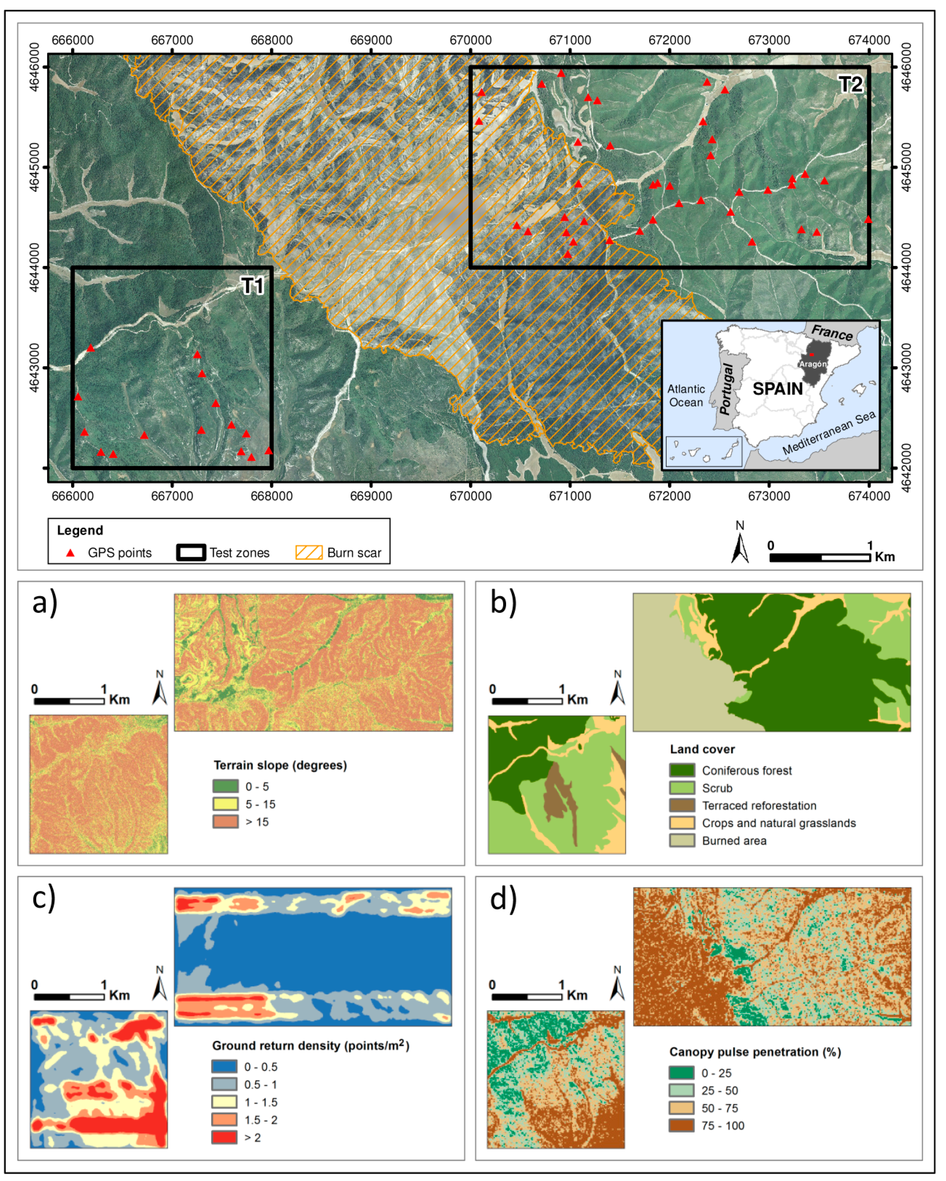
2.2. ALS Data Acquisition

| Property | Value |
|---|---|
| Sensor | ALS60 |
| Scanning method | Oscillating plane mirror (saw-tooth pattern) |
| Date | January and February 2011 |
| Mean flying height above ground (m) | 3012 |
| Mean flying speed (km/h) | 241 |
| Nominal point density (point/m2) | 1.5 |
| Field of view (degrees) | 40 |
| Beam divergence angle (mrad) | 0.22 |
| Scan angle (degrees) | ±22° |
| Total extension of LAS files (km2) | 12 |
| Point count | 18,495,618 |
| Altimetric accuracy (RMSE in m) | 0.20 |
| Planimetric accuracy (RMSE in m) | 0.30 |
2.3. Data Processing
2.3.1. Surface Interpolation Methods
| Method | Advantages/Disadvantages | Parameterization |
|---|---|---|
| Natural neighbor | It is simple because it has no adjustable parameters. It is extremely computationally efficient. It can create artifacts when points are sparse. | Not applicable. |
| Triangulated Irregular Network (TIN) to raster | It is simple and computationally efficient. If point density is lower than the output cell size, the triangle of the intermediate TIN will be transferred to the output DEM. | Linear and natural neighbor methods were tested to create the raster surface from the TIN. |
| Inverse Distance Weighted (IDW) | It requires a moderate decision-making and can also be computationally intensive. | Power of 0.5, 1, 1.5, 2, 2.5 and 3, and a variable search radius with 6, 12 and 24 minimum points were tested. |
| ANUDEM | It allows the incorporation of spatial restrictions in the interpolation process, such as contours, streams, etc. Its primary purpose is to create a surface suitable for hydrologic modeling. It is extremely computationally intensive. | Surfaces were created with drainage enforcement both on and off. |
| Kriging | It requires a lot of decision-making and it is very computationally intensive. | The fitted model of the semivariogram was “Gaussian”. Sector types of 1, 4, 4 with an offset of 45° and 8, with 2 to 5 neighbors were tested. |
| Point to raster | It is the simplest method and it is very computationally efficient. Mean is sensitive to extreme values/outliers, especially when the sample size is small. | Not applicable. |
2.3.2. DEM Accuracy Assessment
2.3.3. Error Analysis
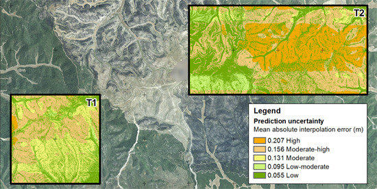
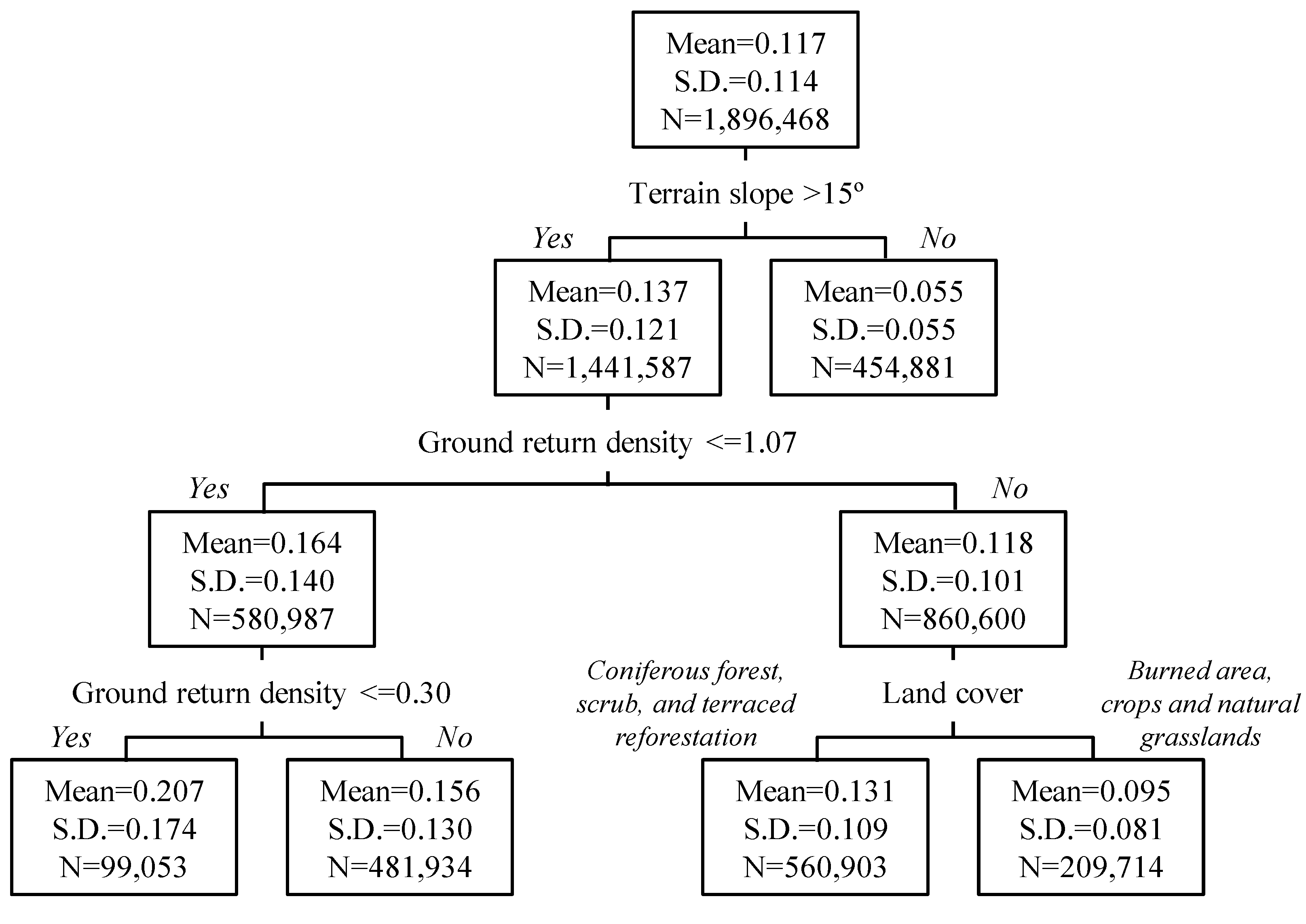
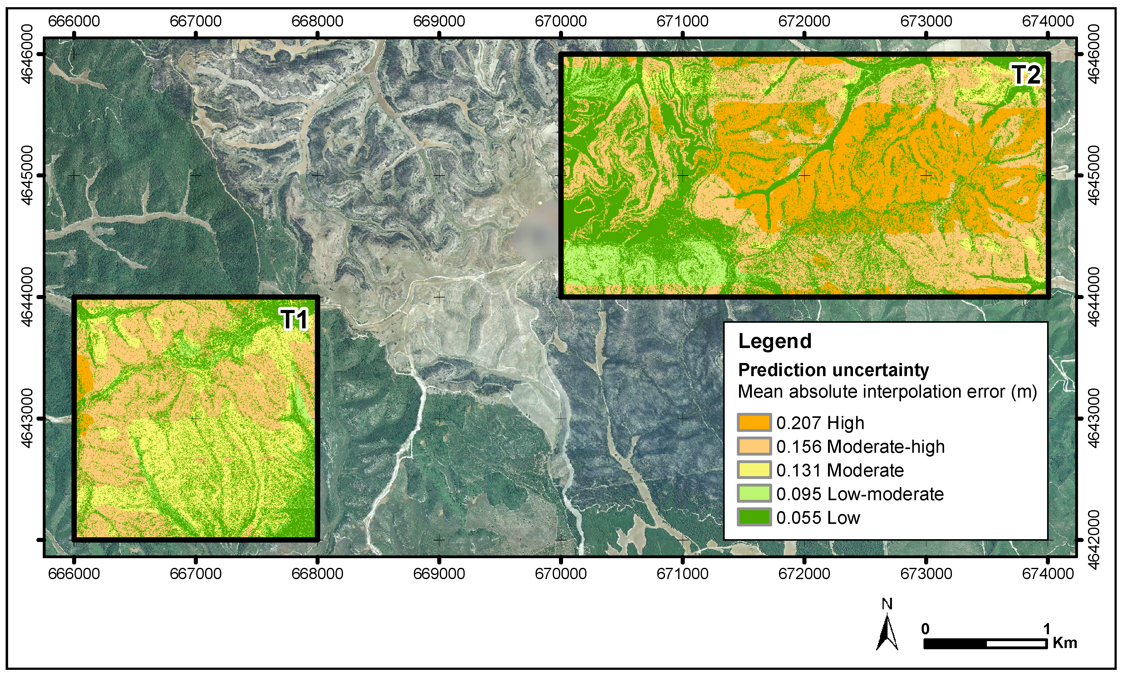
2.3.4. Error Prediction
3. Results
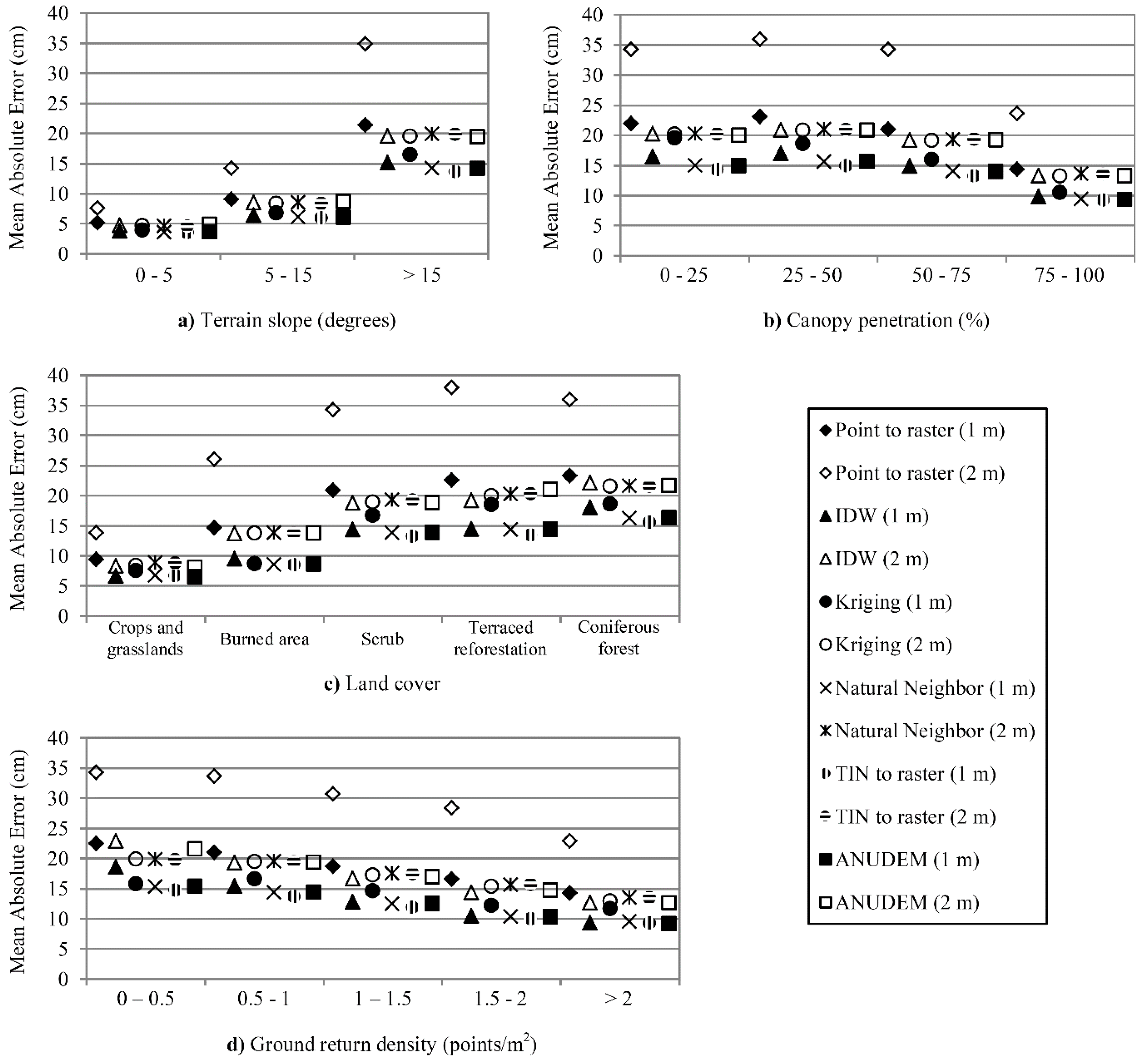
3.1. Error Analysis
| Interpolation Method | Parameterization | Resolution (m) | Min Error (m) | Max Error (m) | Range (m) | SD (m) | ME (cm) | RMSE (cm) | MAE (cm) |
|---|---|---|---|---|---|---|---|---|---|
| TIN to raster | Applying natural neighbor interpolation to TIN triangles to obtain cell values. | 1 | −3.14 | 3.50 | 6.64 | 0.16 | 0.59 | 2.68 | 11.73 |
| Natural neighbor | Not applicable. | 1 | −4.96 | 3.61 | 8.57 | 0.17 | 0.03 | 2.95 | 12.14 |
| ANUDEM | Surface created with no drainage enforcement. | 1 | −3.06 | 3.31 | 6.37 | 0.17 | −0.1 | 2.99 | 12.14 |
| IDW | Power of 2 and variable search radius with 12 minimum points. | 1 | −2.77 | 3.81 | 6.58 | 0.19 | −0.32 | 3.64 | 12.9 |
| Kriging | Parameters determined fitting the semivariogram model. 4 sectors with an offset of 45° for the search neighborhood. | 1 | −4.42 | 4.44 | 8.86 | 0.20 | −0.9 | 3.91 | 14.08 |
| Point to raster | Not applicable. | 1 | −4.45 | 4.24 | 8.69 | 0.26 | −1.29 | 6.64 | 18.25 |
| Kriging | Parameters determined fitting the semivariogram model. 1 sector for the search neighborhood. | 2 | −2.71 | 4.23 | 6.94 | 0.23 | 0.48 | 5.25 | 16.25 |
| ANUDEM | Surface created with no drainage enforcement. | 2 | −2.75 | 3.71 | 6.46 | 0.23 | 0.16 | 5.42 | 16.73 |
| TIN to raster | Applying natural neighbor interpolation to TIN triangles to obtain cell values. | 2 | −4.14 | 3.29 | 7.43 | 0.23 | 0.86 | 5.48 | 16.94 |
| Natural neighbor | Not applicable. | 2 | −3.26 | 3.70 | 6.96 | 0.23 | 0.86 | 5.52 | 16.94 |
| IDW | Power of 2 and variable search radius with 12 minimum points. | 2 | −2.76 | 3.81 | 6.57 | 0.24 | 0.32 | 5.74 | 16.74 |
| Point to raster | Not applicable. | 2 | −4.40 | 4.08 | 8.48 | 0.42 | −2.73 | 17.67 | 29.54 |
| Interpolation Method | Parameterization | Resolution (m) | Min Error (m) | Max Error (m) | Range (m) | SD (m) | ME (cm) | RMSE (cm) | MAE (cm) |
|---|---|---|---|---|---|---|---|---|---|
| IDW | Power of 1 and variable search radius with 24 minimum points. | 1 | −0.05 | 1.24 | 1.29 | 0.22 | 29.80 | 37.10 | 30.01 |
| Kriging | Parameters determined fitting the semivariogram model. 1 sector for the search neighborhood. | 1 | −0.03 | 1.23 | 1.26 | 0.24 | 30.10 | 38.10 | 30.19 |
| Natural neighbor | Not applicable. | 1 | −0.02 | 1.28 | 1.31 | 0.24 | 32.80 | 40.40 | 32.88 |
| TIN to raster | Applying linear interpolation to TIN triangles to obtain cell values. | 1 | 0.03 | 1.44 | 1.40 | 0.28 | 32.70 | 42.80 | 32.67 |
| ANUDEM | Surface created with drainage enforcement. | 1 | −0.04 | 1.49 | 1.53 | 0.31 | 33.90 | 45.40 | 34.16 |
| Point to raster | Not applicable. | 1 | −0.13 | 1.77 | 1.90 | 0.36 | 36.80 | 50.90 | 37.29 |
| IDW | Power of 0.5 and variable search radius with 6 minimum points. | 2 | −0.29 | 1.25 | 1.55 | 0.28 | 29.70 | 40.60 | 31.11 |
| ANUDEM | Surface created with drainage enforcement. | 2 | −0.12 | 1.27 | 1.39 | 0.28 | 32.40 | 42.70 | 33.79 |
| Kriging | Parameters determined fitting the semivariogram model. 1 sector for the search neighborhood. | 2 | −0.03 | 1.58 | 1.61 | 0.30 | 32.50 | 44.10 | 32.67 |
| Natural neighbor | Not applicable. | 2 | −0.05 | 1.86 | 1.90 | 0.32 | 33.20 | 46.00 | 33.37 |
| TIN to raster | Applying linear interpolation to TIN triangles to obtain cell values. | 2 | −0.04 | 1.45 | 1.48 | 0.33 | 34.00 | 47.10 | 34.13 |
| Point to raster | Not applicable. | 2 | −0.15 | 2.53 | 2.68 | 0.49 | 40.00 | 63.00 | 41.10 |

3.3. Error Prediction


4. Discussion
5. Conclusions
Acknowledgments
Author Contributions
Conflicts of Interest
References
- Huising, E.J.; Gomes Pereira, L.M. Errors and accuracy estimates of laser data acquired by various laser scanning systems for topographic applications. ISPRS J. Photogramm. Remote Sens. 1998, 53, 245–261. [Google Scholar] [CrossRef]
- Renslow, M. Manual of Airborne Topographic LiDAR; The American Society for Photogrammetry and Remote Sensing: Bethesda, MD, USA, 2013. [Google Scholar]
- Baltsavias, E.P. A comparison between photogrammetry and laser scanning. ISPRS J. Photogramm. Remote Sens. 1999, 54, 83–94. [Google Scholar] [CrossRef]
- Razak, K.A.; Straatsma, M.W.; van Westen, C.J.; Malet, J.P.; de Jong, S.M. Airborne laser scanning of forested landslides characterization: Terrain model quality and visualization. Geomorphology 2011, 126, 186–200. [Google Scholar] [CrossRef]
- Kraus, K.; Pfeifer, N. Determination of terrain models in wooded areas with airborne laser scanner data. ISPRS J. Photogramm. Remote Sens. 1998, 53, 193–203. [Google Scholar] [CrossRef]
- Aguilar, F.J.; Mills, J.P.; Delgado, J.; Aguilar, M.A.; Negreiros, J.G.; Pérez, J.L. Modelling vertical error in LiDAR-derived digital elevation models. ISPRS J. Photogramm. Remote Sens. 2010, 65, 103–110. [Google Scholar] [CrossRef]
- Kraus, K.; Pfeifer, N. Advanced DTM generation from LiDAR data. Int. Arch. Photogramm. Remote Sens. Spat. Inf. Sci. 2001, 34, 23–30. [Google Scholar]
- Lohr, U. Digital elevation models by laser scanning. Photogramm. Rec. 1998, 16, 105–109. [Google Scholar] [CrossRef]
- Wehr, A.; Lohr, U. Airborne laser scanning: An introduction and overview. ISPRS J. Photogramm. Remote Sens. 1999, 54, 68–82. [Google Scholar] [CrossRef]
- Lefsky, M.A.; Cohen, W.B.; Parker, G.G.; Harding, D.J. LiDAR remote sensing for ecosystem studies. BioScience 2002, 19–30. [Google Scholar] [CrossRef]
- Liu, X.; Zhang, Z.; Peterson, J.; Chandra, S. LiDAR-derived high quality ground control information and DEM for image orthorectification. GeoInformatica 2007, 11, 37–53. [Google Scholar] [CrossRef] [Green Version]
- Lloyd, C.D.; Atkinson, P.M. Deriving ground surface digital elevation models from LiDAR data with geostatistics. Int. J. Geogr. Inf. Sci. 2006, 20, 535–563. [Google Scholar] [CrossRef]
- Vosselman, G.; Maas, H.-G. Airborne and Terrestrial Laser Scanning; Whittles Publishing: Dunbeath, UK, 2010. [Google Scholar]
- Næsset, E. Determination of mean tree height of forest stands using airborne laser scanner data. ISPRS J. Photogramm. Remote Sens. 1997, 52, 49–56. [Google Scholar] [CrossRef]
- Næsset, E. Estimating timber volume of forest stands using airborne laser scanner data. Remote Sens. Environ. 1997, 61, 246–253. [Google Scholar] [CrossRef]
- Means, J.E.; Acker, S.A.; Fitt, B.J.; Renslow, M.; Emerson, L.; Hendrix, C.J. Predicting forest stand characteristics with airborne LiDAR. Photogramm. Eng. Remote Sens. 2000, 66, 1367–1371. [Google Scholar]
- Lefsky, M.A.; Cohen, W.B.; Acker, S.A.; Parker, G.G.; Spies, T.A.; Harding, D. LiDAR remote sensing of the canopy structure and biophysical properties of douglas-fir western hemlock forests. Remote Sens. Environ. 1999, 70, 339–361. [Google Scholar] [CrossRef]
- Dubayah, R.O.; Drake, J.B. LiDAR Remote sensing for forestry. J. For. 2000, 98, 44–46. [Google Scholar]
- Lim, K.; Treitz, P.; Wulder, M.; St-Onge, B.; Flood, M. LiDAR remote sensing of forest structure. Prog. Phys. Geogr. 2003, 27, 88–106. [Google Scholar] [CrossRef]
- Riaño, D.; Meier, E.; Allgöwer, B.; Chuvieco, E.; Ustin, S.L. Modeling airborne laser scanning data for the spatial generation of critical forest parameters in fire behavior modeling. Remote Sens. Environ. 2003, 86, 177–186. [Google Scholar] [CrossRef]
- Hall, S.A.; Burke, I.C.; Box, D.O.; Kaufmann, M.R.; Stoker, J.M. Estimating stand structure using discrete-return LiDAR: An example from low density, fire prone ponderosa pine forests. For. Ecol. Manag. 2005, 208, 189–209. [Google Scholar] [CrossRef]
- Bater, C.W.; Coops, N.C. Evaluating error associated with LiDAR-derived DEM interpolation. Comput. Geosci. 2009, 35, 289–300. [Google Scholar] [CrossRef]
- Vaze, J.; Teng, J.; Spencer, G. Impact of DEM accuracy and resolution on topographic indices. Environ. Model. Softw. 2010, 25, 1086–1098. [Google Scholar] [CrossRef]
- Sithole, G.; Vosselman, G. Experimental comparison of filter algorithms for bare-Earth extraction from airborne laser scanning point clouds. ISPRS J. Photogramm. Remote Sens. 2004, 59, 85–101. [Google Scholar] [CrossRef]
- Liu, X. Accuracy assessment of LiDAR elevation data using survey marks. Surv. Rev. 2011, 43, 80–93. [Google Scholar] [CrossRef]
- Guo, Q.; Li, W.; Yu, H.; Alvarez, O. Effects of topographic variability and LiDAR sampling density on several DEM interpolation methods. Photogramm. Eng. Remote Sens. 2010, 76, 701–712. [Google Scholar] [CrossRef]
- Gonga-Saholiariliva, N.; Gunnell, Y.; Petit, C.; Mering, C. Techniques for quantifying the accuracy of gridded elevation models and for mapping uncertainty in digital terrain analysis. Progr. Phys. Geogr. 2011, 35, 739–764. [Google Scholar] [CrossRef]
- Bilskie, M.V.; Hagen, S.C. Topographic accuracy assessment of bare earth LiDAR-derived unstructured meshes. Adv. Water Resour. 2013, 52, 165–177. [Google Scholar] [CrossRef]
- Aguilar, F.J.; Aguilar, M.A.; Agüera, F.; Sánchez, J. The accuracy of grid digital elevation models linearly constructed from scattered sample data. Int. J. Geogr. Inf. Sci. 2006, 20, 169–192. [Google Scholar] [CrossRef]
- Clark, M.L.; Clark, D.B.; Roberts, D.A. Small-footprint LiDAR estimation of sub-canopy elevation and tree height in a tropical rain forest landscape. Remote Sens. Environ. 2004, 91, 68–89. [Google Scholar] [CrossRef]
- Hopkinson, C.C.; Chasmer, L.E.; Zsigovics, G.; Creed, I.F.; Sitar, M.; Treitz, P.; Maher, R.V. Errors in LiDAR ground elevation and wetland vegetation height estimates. Proc. Int. Arch. Photogramm. Remote Sens. Spat. Inf. Sci. 2004, 36, 108–113. [Google Scholar]
- Su, J.; Bork, E. Influence of vegetation, slope and LiDAR sampling angle on DEM accuracy. Photogramm. Eng. Remote Sens. 2006, 72, 1265–1274. [Google Scholar] [CrossRef]
- Desmet, P.J.J. Effects of interpolation errors on the analysis of DEMs. Earth Surf. Process. Landf. 1997, 22, 563–580. [Google Scholar] [CrossRef]
- Gong, J.; Li, Z.; Zhu, Q.; Sui, H.; Zhou, Y. Effects of various factors on the accuracy of DEMs: An intensive experimental investigation. Photogramm. Eng. Remote Sens. 2000, 66, 1113–1117. [Google Scholar]
- Schoorl, J.M.; Sonneveld, M.P.W.; Veldkamp, A. Three-dimensional landscape process modelling: The effect of DEM resolution. Earth Surf. Process. Landf. 2000, 25, 1025–1034. [Google Scholar] [CrossRef]
- Anderson, E.S.; Thompson, J.A.; Crouse, D.A.; Austin, R.E. Horizontal resolution and data density effects on remotely sensed LIDAR-based DEM. Geoderma 2006, 132, 406–415. [Google Scholar] [CrossRef]
- Fisher, P.F.; Tate, N.J. Causes and consequences of error in digital elevation models. Prog. Phys. Geogr. 2006, 30, 467–489. [Google Scholar] [CrossRef]
- Hodgson, M.E.; Bresnahan, P. Accuracy of airborne LiDAR-derived elevation. Photogramm. Eng. Remote Sens. 2004, 70, 331–339. [Google Scholar] [CrossRef]
- Aguilar, F.J.; Mills, J.P. Accuracy assessment of LiDAR-derived digital elevation models. Photogramm. Rec. 2008, 23, 148–169. [Google Scholar] [CrossRef]
- Spanish National Plan for Aerial Orthophotography (PNOA). Available online: http://pnoa.ign.es/presentacion (accessed on 2 July 2015).
- 3D Elevation Program (3DEP) of the U.S. Geological Survey National Geospatial Program (NGP). Available online: http://nationalmap.gov/3DEP/ (accessed on 13 June 2015).
- Gatziolis, D.; Fried, J.S.; Monleon, V.S. Challenges to estimating tree height via LiDAR in closed-canopy forests: A parable from western Oregon. For. Sci. 2010, 56, 139–155. [Google Scholar]
- McGaughey, R. FUSION/LDV: Software for LIDAR Data Analysis and Visualization; US Department of Agriculture, Forest Service, Pacific Northwest Research Station: Seattle, WA, USA, 2009.
- Vicente-Serrano, S.M.; Lasanta, T.; Gracia, C. Aridification determines changes in forest growth in Pinus halepensis forests under semiarid Mediterranean climate conditions. Agric. For. Meteorol. 2010, 150, 614–628. [Google Scholar] [CrossRef]
- Notivol, E.; Cabanillas, A.; González, R.; Revuelta, C. Caracterización de masas naturales de pino carrasco (Pinus halepensis Mill.) en la Depresión del Ebro. In Proceedings of the La Ciencia Forestal: Respuestas para la Sostenibilidad, 4° Congreso Forestal Español, Zaragoza, Spain, 26–30 September 2005; p. 7.
- Tanase, M.; de la Riva, J.; Pérez-Cabello, F. Estimating burn severity at the regional level using optically based indices. Can. J. For. Res. 2011, 41, 863–872. [Google Scholar] [CrossRef]
- Tanase, M.; de la Riva, J.; Santoro, M.; Pérez-Cabello, F.; Kasischke, E. Sensitivity of SAR data to post-fire forest regrowth in Mediterranean and boreal forests. Remote Sens. Environ. 2011, 115, 2075–2085. [Google Scholar] [CrossRef]
- Chuvieco, E. Earth Observation of Wildland Fires in Mediterranean Ecosystems; Springer-Verlag: Berlin/Heidelberg, Germany, 2009. [Google Scholar]
- Evans, J.S.; Hudak, A.T. A multiscale curvature algorithm for classifying discrete return LiDAR in forested environments. IEEE Trans. Geosci. Remote Sens. 2007, 45, 1029–1038. [Google Scholar] [CrossRef]
- Montealegre, A.L.; Lamelas, M.T.; de la Riva, J. A comparison of open source LiDAR filtering algorithms in a Mediterranean forest environment. IEEE Trans. Sel. Top. Appl. Earth Observ. Remote Sens. 2015, 2015. [Google Scholar] [CrossRef]
- Sibson, R. A brief description of natural neighbour interpolation. In Interpreting Multivariate Data; Barnett, V., Ed.; John Wiley & Sons: New York, NY, USA, 1981; pp. 21–36. [Google Scholar]
- Sambridge, M.; Braun, J.; McQueen, H. Geophysical parametrization and interpolation of irregular data using natural neighbours. Geophys. J. Int. 1995, 122, 837–857. [Google Scholar] [CrossRef]
- Hutchinson, M.F. A new procedure for gridding elevation and stream line data with automatic removal of spurious pits. J. Hydrol. 1989, 106, 211–232. [Google Scholar] [CrossRef]
- Cressie, N. Spatial prediction and ordinary kriging. Math. Geol. 1988, 20, 405–421. [Google Scholar] [CrossRef]
- Caruso, C.; Quarta, F. Interpolation methods comparison. Comput. Math. Appl. 1998, 35, 109–126. [Google Scholar] [CrossRef]
- Zhang, X.F.; van Eijkeren, J.C.H.; Heemink, A.W. On the weighted least-squares method for fitting a semivariogram model. Comput. Geosci. 1995, 21, 605–608. [Google Scholar] [CrossRef]
- Chu, H.-J.; Chen, R.-A.; Tseng, Y.-H.; Wang, C.-K. Identifying LiDAR sample uncertainty on terrain features from DEM simulation. Geomorphology 2014, 204, 325–333. [Google Scholar] [CrossRef]
- Breiman, L.; Friedman, J.H.; Olshen, R.A.; Stone, C.J. Classification and Regression Trees; Wadsworth International Group: Pacific Grove, CA, USA, 1984. [Google Scholar]
- Zheng, H.; Chen, L.; Han, X.; Zhao, X.; Ma, Y. Classification and regression tree (CART) for analysis of soybean yield variability among fields in Northeast China: The importance of phosphorus application rates under drought conditions. Agric. Ecosyst. Environ. 2009, 132, 98–105. [Google Scholar] [CrossRef]
- Tayyebi, A.; Pijanowski, B.C. Modeling multiple land use changes using ANN, CART and MARS: Comparing tradeoffs in goodness of fit and explanatory power of data mining tools. Int. J. Appl. Earth Observ. Geoinf. 2014, 28, 102–116. [Google Scholar] [CrossRef]
- Lawrence, R.L.; Wright, A. Rule-based classification systems using classification and regression tree (CART) analysis. Photogramm. Eng. Remote Sens. 2001, 67, 1137–1142. [Google Scholar]
- Brown de Colstoun, E.C.; Story, M.H.; Thompson, C.; Commisso, K.; Smith, T.G.; Irons, J.R. National Park vegetation mapping using multitemporal Landsat 7 data and a decision tree classifier. Remote Sens. Environ. 2003, 85, 316–327. [Google Scholar] [CrossRef]
- Hladik, C.; Alber, M. Classification of salt marsh vegetation using edaphic and remote sensing-derived variables. Estuar. Coast. Shelf Sci. 2014, 141, 47–57. [Google Scholar] [CrossRef]
- Gallay, M.; Lloyd, C.; McKinley, J. Optimal interpolation of airborne laser scanner data for fine-scale DEM validation purposes. In Proceedings of Symposium GIS Ostrava 2012—Surface models for Geosciences, Ostrava, Czech Republic, 23–25 January 2012.
- Rees, W.G. The accuracy of Digital Elevation Models interpolated to higher resolutions. Int. J. Remote Sens. 2000, 21. [Google Scholar] [CrossRef]
- Mitášová, H.; Mitáš, L.; Harmon, R.S. Simultaneous spline approximation and topographic analysis for ALS elevation data in open source GIS. IEEE Geosci. Remote Sens. Lett. 2005, 2, 375–379. [Google Scholar] [CrossRef]
- Lloyd, C.D.; Atkinson, P.M. Deriving DSMs from LiDAR data with kriging. Int. J. Remote Sens. 2002, 23, 2519–2524. [Google Scholar] [CrossRef]
- Goodwin, N.R.; Coops, N.C.; Culvenor, D.S. Assessment of forest structure with airborne LiDAR and the effects of platform altitude. Remote Sens. Environ. 2006, 103, 140–152. [Google Scholar] [CrossRef]
- Smith, S.L.; Holland, D.A.; Longley, P.A. Quantifying interpolation errors in urban airborne laser scanning models. Geogr. Anal. 2005, 37, 200–224. [Google Scholar] [CrossRef]
- Behan, A. On the matching accuracy of rasterized scanning laser altimeter data. Int. Arch. Photogramm. Remote Sens. 2000, 33, 75–82. [Google Scholar]
- Hu, P.; Liu, X.; Hu, H. Accuracy assessment of digital elevation models based on approximation theory. Photogramm. Eng. Remote Sens. 2009, 75, 49–56. [Google Scholar] [CrossRef]
- Aguilar, F.J.; Agüera, F.; Aguilar, M.A.; Carvajal, F. Effects of terrain morphology, sampling density, and interpolation methods on grid DEM accuracy. Photogramm. Eng. Remote Sens. 2005, 71, 805–816. [Google Scholar] [CrossRef]
© 2015 by the authors; licensee MDPI, Basel, Switzerland. This article is an open access article distributed under the terms and conditions of the Creative Commons Attribution license (http://creativecommons.org/licenses/by/4.0/).
Share and Cite
Montealegre, A.L.; Lamelas, M.T.; Riva, J.D.l. Interpolation Routines Assessment in ALS-Derived Digital Elevation Models for Forestry Applications. Remote Sens. 2015, 7, 8631-8654. https://doi.org/10.3390/rs70708631
Montealegre AL, Lamelas MT, Riva JDl. Interpolation Routines Assessment in ALS-Derived Digital Elevation Models for Forestry Applications. Remote Sensing. 2015; 7(7):8631-8654. https://doi.org/10.3390/rs70708631
Chicago/Turabian StyleMontealegre, Antonio Luis, María Teresa Lamelas, and Juan De la Riva. 2015. "Interpolation Routines Assessment in ALS-Derived Digital Elevation Models for Forestry Applications" Remote Sensing 7, no. 7: 8631-8654. https://doi.org/10.3390/rs70708631