
Contraction of the Gobi Desert, 2000–2012


Abstract
:1. Introduction

| Source | Size (million km2) | Assessment Year | Methodology |
|---|---|---|---|
| Cressy, 1960 [18] | 1.7 | none | None specified |
| NASA, 2011 [19] | 1.3 | none | None specified |
| Stoppato and Bini, 2003 [20] | 1.3 | none | None specified |
| Yu et al., 2004 [21] | 1.16–1.57 | 2001 | NDVI 1982–1990 |
| Yu et al., 2004 [21] | 1.3 | none | None specified |
| Laurent et al., 2005 [22] | 1.3 | none | None specified |
| Dennell, 2012 [23] | 1.3 | none | None specified |
2. Methods
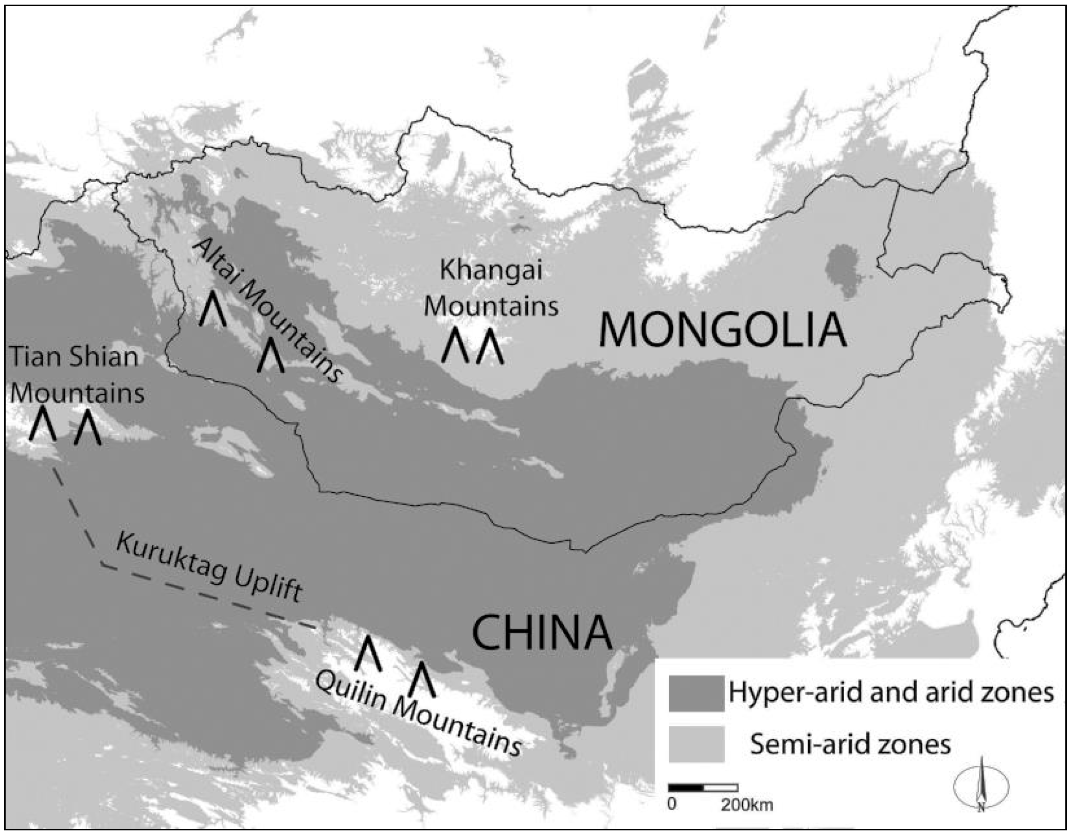
2.1. Study Area
2.2. Methods
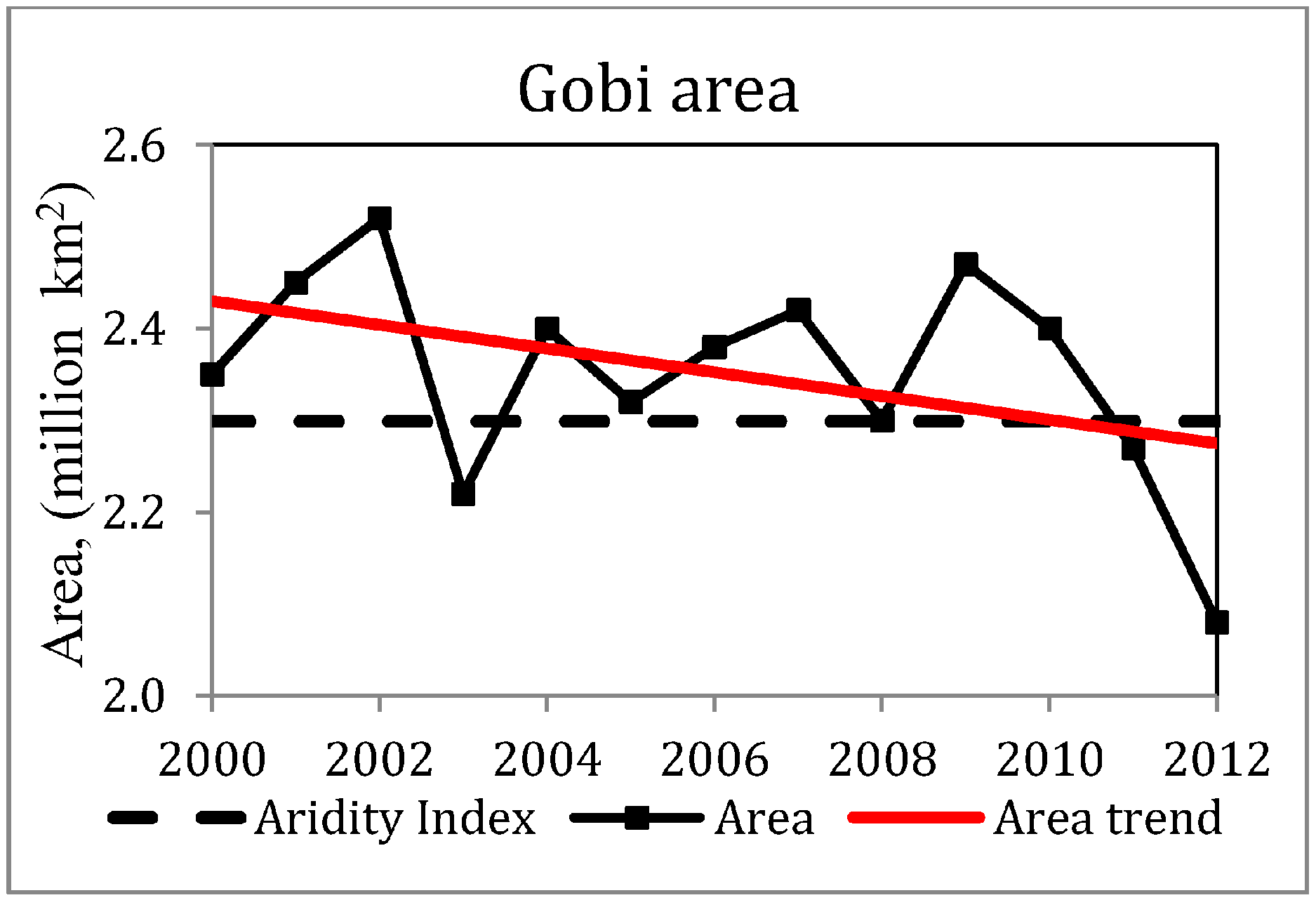
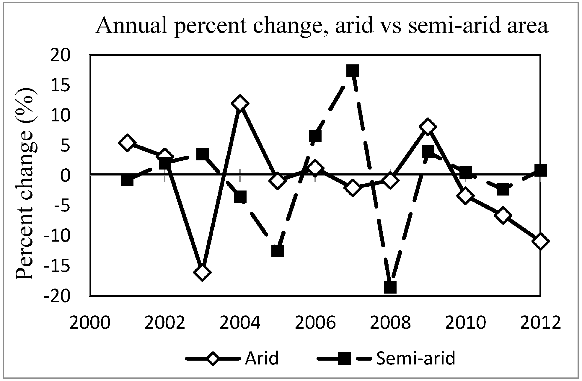
3. Results
| Year | Arid | Change (%) | Change (%) | Semi-Arid | Change (%) | Change (%) | Total | Change (%) | Change (%) |
|---|---|---|---|---|---|---|---|---|---|
| km2 | year to year | from mean | year to year | from mean | year to year | from mean | |||
| 2000 | 1,797,132 | -- | −0.7 | 560,109 | -- | 2.6 | 2,357,241 | -- | 0.1 |
| 2001 | 1,895,250 | 5.5 | 4.6 | 556,225 | −0.7 | 1.9 | 2,451,475 | 4.0 | 4.1 |
| 2002 | 1,954,933 | 3.1 | 7.5 | 567,829 | 2.1 | 3.9 | 2,522,761 | 2.9 | 6.9 |
| 2003 | 1,640,889 | −16.1 | −10.2 | 588,290 | 3.6 | 7.3 | 2,229,179 | −11.6 | −5.0 |
| 2004 | 1,837,586 | 12.0 | 1.6 | 567,578 | −3.5 | 3.9 | 2,405,165 | 7.9 | 2.3 |
| 2005 | 1,822,172 | −0.8 | 0.7 | 496,516 | −12.5 | −9.9 | 2,318,688 | −3.6 | −1.5 |
| 2006 | 1,844,999 | 1.3 | 2.0 | 529,526 | 6.6 | −3.0 | 2,374,524 | 2.4 | 0.9 |
| 2007 | 1,807,383 | −2.0 | −0.1 | 622,040 | 17.5 | 12.3 | 2,429,423 | 2.3 | 3.2 |
| 2008 | 1,793,119 | −0.8 | −0.9 | 506,806 | −18.5 | −7.6 | 2,299,925 | −5.3 | −2.2 |
| 2009 | 1,938,552 | 8.1 | 6.7 | 527,022 | 4.0 | −3.5 | 2,465,575 | 7.2 | 4.8 |
| 2010 | 1,873,921 | −3.3 | 3.5 | 529,672 | 0.5 | −3.0 | 2,403,593 | −2.5 | 2.0 |
| 2011 | 1,750,568 | −6.6 | −3.3 | 517,749 | −2.3 | −5.4 | 2,268,316 | −5.6 | −3.6 |
| 2012 | 1,559,640 | −10.9 | −16.0 | 522,473 | 0.9 | −4.4 | 2,082,113 | −8.2 | −12.0 |
| mean | 1,808,934 | --- | --- | 545,526 | --- | --- | 2,354,460 | --- | --- |


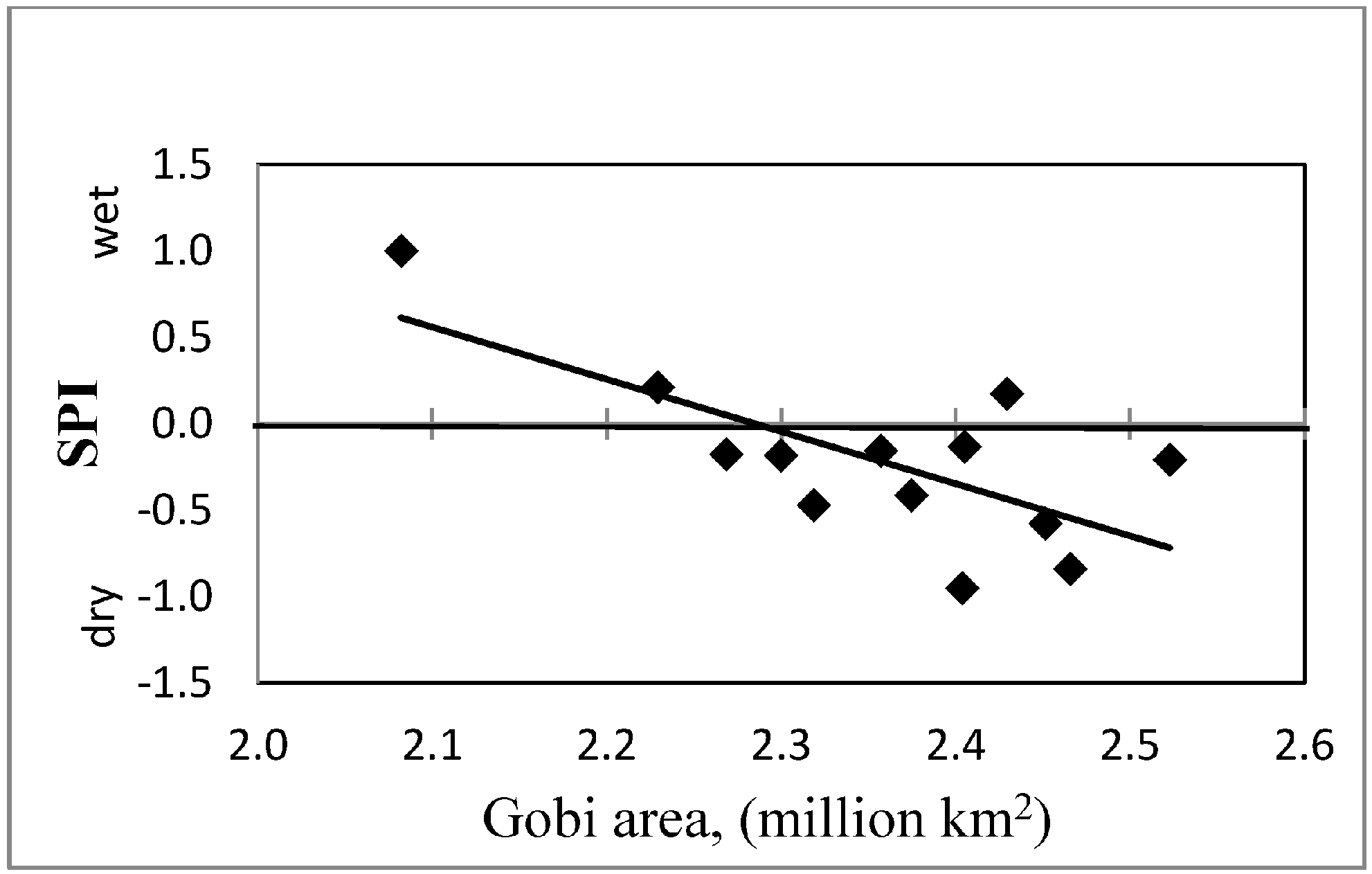
4. Discussion
5. Conclusion
Acknowledgements
Author Contributions
Conflicts of Interest
References
- Safriel, U.; Adeel, Z.; Niemeijer, D.; Puigfefabregas, J.; White, R.; Lal, R. Dryland systems. In Millennium Ecosystem Assessment: Ecosystems and Human Well-Being: Current State and Trends; El-Kassas, M., Ezcurra, E., Eds.; Island Press: Washington, DC, USA, 2005; pp. 623–662. [Google Scholar]
- Food and Agriculture Organization of the United Nations (FAO). Water and Cereals in Drylands; Earthscan: London, UK, 2008. [Google Scholar]
- Davies, J.; Poulsen, L.; Schulte-Herbrüggen, B.; Mackinnon, K.; Crawhall, N.; Henwood, W.; Dudley, N.; Smith, J.; Gudka, M. Conserving Dryland Biodiversity; International Union for Conservation of Nature (IUCN): Nairobi, Kenya, 2012. [Google Scholar]
- D’Odorico, P.; Bhattachan, A.; Davis, K.; Ravi, S.; Runyan, C. Global desertification: Drivers and feedbacks. Adv. Water Resour. 2013, 51, 326–344. [Google Scholar] [CrossRef]
- Tucker, C.; Dregne, H.; Newcomb, W. Expansion and contraction of the Sahara Desert from 1980 to 1990. Science 1991, 253, 299–301. [Google Scholar] [CrossRef] [PubMed]
- Jeong, S.; Ho, C.; Brown, M.; Kug, J.; Piao, S. Browning in desert boundaries in Asia in recent decades. J. Geophys. Res. 2011. [Google Scholar] [CrossRef]
- Wang, X.; Chen, F.; Hasi, E.; Li, J. Desertification in China: An assessment. Earth-Sci. Rev. 2008, 88, 188–206. [Google Scholar] [CrossRef]
- Zhu, Z.; Sleeter, B.; Griffith, G.; Stackpoole, S.; Hawbaker, T.; Bergamaschi, B. An Assessment of Carbon Sequestration in Ecosystems of the Western United States—Scope, Methodology, and Geography; U.S. Geological Survey Professional Paper 1797; U.S. Geological Survey: Reston, VA, USA, 2012. Available online: http://pubs.usgs/gov/pp/1797 (accessed on 20 March 2014).
- Poulter, B.; Frank, D.; Ciais, P.; Myneni, R.B.; Andela, N.; Bi, J.; Broquet, G.; Canadell, J.G.; Chevallier, F.; Liu, Y.Y.; et al. Contribution of semi-arid ecosystems to interannual variability of the global carbon cycle. Nature 2014, 509, 600–603. [Google Scholar] [CrossRef] [PubMed]
- Stoms, D.; Hargrove, W. Potential NDVI as a baseline for monitoring ecosystem functioning. Int. J. Remote Sens. 2000, 21, 401–407. [Google Scholar] [CrossRef]
- Reynolds, J.F.; Smith, D.M.S.; Lambin, E.F.; Turner, B.L., II; Mortimore, M.; Batterbury, S.P.J.; Downing, T.E.; Dowlatabadi, H.; Fernández, R.J.; Herrick, J.E.; et al. Global desertification: building a science for dryland development. Science 2007, 316, 847–851. [Google Scholar] [CrossRef] [PubMed]
- Thomas, D.; Middleton, N. Desertification: Exploding the Myth; Wiley: Chichester, UK, 1994. [Google Scholar]
- Food and Agriculture Organization of the United Nations (FAO). Drylands, People and Land Use. 2009. Available online: fao.org/docrep/012/i0372e/i0372e01.pdf (accessed on 26 May 2014).
- Shi, Y.; Shen, Y.; Kang, E.; Li, D.; Ding, Y.; Zhang, G.; Hu, R. Recent and future climate change in Northwest China. Clim. Chang. 2007, 80, 379–393. [Google Scholar] [CrossRef]
- Lu, W.; Jia, G. Fluctuation of farming-pastoral ecotone in association with changing East Asia monsoon climate. Clim. Chang. 2013, 119, 747–760. [Google Scholar] [CrossRef]
- Von Wehrden, H.; Wesche, K. Relationships between climate, productivity and vegetation in southern Mongolian drylands. Basic Appl. Dryland Res. 2007, 1, 100–120. [Google Scholar] [CrossRef] [PubMed]
- Sternberg, T. Desert boundaries: The once and future Gobi. Geogr. J. 2014. [Google Scholar] [CrossRef]
- Cressey, G. The Deserts of Asia; Syracuse University: Syracuse, NY, USA, 1960. [Google Scholar]
- NASA. Dust storm in Gobi Desert, Mongolia. 2002. Available online: visibleearth.nasa.gov/view.php?id=63315 (accessed on 23 January 2015).
- Stoppato, M.; Bini, A. Deserts; Firefly Books: Toronto, ON, Canada, 2003. [Google Scholar]
- Yu, F.; Price, K.; Ellis, J.; Feddema, J.; Shi, P. Interannual variations of the grassland boundaries bordering the eastern edges of the Gobi Desert in central Asia. Int. J Remote Sens. 2004, 25, 327–343. [Google Scholar]
- Laurent, B.; Marticorena, B.; Bergametti, G.; Chazette, P.; Maignan, F.; Schmechtig, C. Simulation of the mineral dust emission frequencies from desert areas of China and Mongolia using an aerodynamic roughness length map derived from the POLDER. J. Geophys. Res. 2005. [Google Scholar] [CrossRef]
- Dennell, R. Hominins, deserts, and the colonisation and settlement of continental Asia. Quatern. Int. 2012, 300, 13–21. [Google Scholar] [CrossRef]
- Yang, X.; Zhang, K.; Jia, B.; Ci, L. Desertification assessment in China: An overview. J. Arid Environ. 2005, 63, 517–531. [Google Scholar] [CrossRef]
- Regdel, D.; Dugarzhav, C.; Gunin, P. Ecological demands on socioeconomic development of Mongolia under climate aridization. Arid Ecosyst. 2012, 2, 1–10. [Google Scholar] [CrossRef]
- Wang, X.; Zhang, C.; Hasi, E.; Dong, Z. Has the Three Norths Forest Shelterbelt Program solved the desertification and duststorm problems in arid and semiarid China? J Arid Environ. 2010, 74, 13–22. [Google Scholar] [CrossRef]
- Eldridge, D.; Bowker, M.; Maestre, F.; Roger, E.; Reynolds, J.F.; Whitford, W.G. Impacts of shrub encroachment on ecosystem structure and functioning: Towards a global synthesis. Ecol. Lett. 2011, 14, 709–722. [Google Scholar] [CrossRef] [PubMed]
- Dalintai, B.; Yanbo, L.; Jianjun, C. The Eurasian Steppe: History of utilization and policies on the rangeland. In Restoring Community Connections to the Land; Fernandez-Gimenez, M.E., Wang, X., Baival, B., Klein, J., Reid, R., Eds.; CABI: Wallingford, UK, 2011; pp. 51–68. [Google Scholar]
- Cao, S.; Chen, L.; Shankman, D.; Wang, C.; Wang, X.; Zhang, H. Excessive reliance on afforestation in China’s arid and semi-arid regions: Lessons in ecological restoration. Earth-Sci. Rev. 2011, 104, 240–245. [Google Scholar] [CrossRef]
- Addison, J.; Friedel, M.; Brown, C.; Davies, J.; Waldron, S. A critical review of degradation assumptions applied to Mongolia’s Gobi Desert. Rangel. J. 2012, 34, 125–137. [Google Scholar] [CrossRef]
- Thomas, D. Arid Zone Geomorphology; Wiley-Blackwell: Chichester, UK, 2011. [Google Scholar]
- Middleton, N. Deserts: A Very Short Introduction; Oxford University Press (OUP): Oxford, UK, 2009. [Google Scholar]
- Goudie, A.; Middleton, N. Desert Dust in the Global System; Springer: Heidelberg, Germany, 2006. [Google Scholar]
- Han, J.; Zhang, Y.; Wang, C.; Bai, W.; Wang, Y.; Han, G.; Li, L. Rangeland degradation and restoration management in China. Rangel. J. 2008, 30, 233–239. [Google Scholar] [CrossRef]
- Trabucco, A.; Zomer, R. Global Aridity Index (Global-Aridity) and Global Potential Evapo-Transpiration (Global-PET) Geospatial Database, 2009. CGIAR Consortium for Spatial Information. Available online: www.csi.cgiar.org/ (accessed on 22 January 2013).
- Karnieli, A.; Bayarjargal, Y.; Bayasgalan, M.; Mandakh, B.; Dugarjav, C.; Burgheimer, J.; Khudulmur, S.; Bazha, S.; Gunin, P. Do vegetation indices provide a reliable indication of vegetation degradation? A case study in the Mongolian pastures. Int. J. Remote Sens. 2013, 34, 6243–6262. [Google Scholar] [CrossRef]
- Shoshany, M. Identifying desert thresholds by mapping inverse erodibility and recovery potentials in patch patterns using spectral and morphological algorithms. Land Degrad. Dev. 2012, 23, 31–338. [Google Scholar] [CrossRef]
- Sternberg, T.; Thomas, D.; Middleton, N. Drought dynamics on the Mongolian steppe, 1970–2006. Int. J. Climatol. 2011, 31, 1823–1830. [Google Scholar] [CrossRef]
- Chen, Z.; Li, J.; Fang, K.; Davi, N.; He, X.; Cui, M.; Zhang, X.; Peng, J. Seasonal dynamics of vegetation over the past 100 years inferred from tree rings and climate in Hulunbei’er steppe, northern China. J. Arid. Environ. 2012, 83, 86–93. [Google Scholar] [CrossRef]
- Piao, S.; Fang, J.; Liu, H.; Zhu, B. NDVI-indicated decline in desertification in China in the past two decades. Geophys. Res. Lett. 2005. [Google Scholar] [CrossRef]
- Earth Observing System Data and Information System. 2009. Available online: http://www.echo.nasa.gov/reverb (accessed on 26 February 2014).
- Tachiiri, K.; Shinoda, M.; Klinkenberg, B.; Morinaga, Y. Assessing Mongolian snow disaster risk using livestock and satellite data. J. Arid Environ. 2008, 72, 2251–2263. [Google Scholar] [CrossRef]
- Sternberg, T.; Tsolmon, R.; Middleton, N.; Thomas, D. Tracking desertification on the Mongolian steppe through NDVI and field-survey data. Int. J. Dig. Earth 2010, 1, 50–64. [Google Scholar]
- Hao, F.; Zhang, X.; Ouyang, W.; Skidmore, A.; Toxopeus, A. Vegetation NDVI linked to temperature and precipitation in the upper catchments of Yellow River. Environ. Model. Assess. 2012, 17, 389–398. [Google Scholar] [CrossRef]
- Jolivet, M.; Brunel, M.; Seward, D.; Xu, Z.; Yang, J.; Roger, F.; Tapponnier, P.; Malavieille, J.; Arnaud, N.; Wu, C. Mesozoic and Cenozoic tectonics of the northern edge of the Tibetan plateau: Fission-track constraints. Tectonophysics 2001, 34, 111–134. [Google Scholar] [CrossRef]
- Zhang, B.; Tsunekawa, A.; Tsuboa, M. Contributions of sandy lands and stony deserts to long-distance dust emission in China and Mongolia during 2000–2006. Glob. Planet Chang. 2008, 60, 487–504. [Google Scholar] [CrossRef]
- Wang, Q.; Nishidai, T.; Coward, M. The Tarim basin, NW China: Formation and aspects of petroleum geology. J. Petrol. Geol. 1992, 15, 5–34. [Google Scholar] [CrossRef]
- Keyantash, J.; Dracup, J. The quantification of drought: An analysis of drought indices. Bull. Am. Meteorol. Soc. 2002, 83, 1167–1180. [Google Scholar] [CrossRef]
- Sternberg, T.; Middleton, N.; Thomas, D. Pressurised pastoralism in South Gobi, Mongolia: what is the role of drought? Trans. Inst. Br. Geogr. 2009, 34, 364–377. [Google Scholar] [CrossRef]
- Hayes, M.; Svoboda, M.; Wilhite, D.; Vanyarkho. Monitoring the 1996 drought using the standardized precipitation index. Bull. Am. Meteorol. Soc. 1999, 80, 429–438. [Google Scholar] [CrossRef]
- Myoung, B.; Choi, Y.; Choi, S.; Park, S. Impact of vegetation on land-atmosphere coupling strength and its implication for desertification mitigation over East Asia. J. Geophys. Res. 2012. [Google Scholar] [CrossRef]
- Meigs, P. World Distribution of Arid and Semi-Arid Homoclimates; United Nations: Paris, France, 1953. [Google Scholar]
- Rudaya, N.; Li, H.C. A new approach for reconstruction of the Holocene climate in the Mongolian Altai: The high-resolution δ 13C records of TOC and pollen complexes in Hoton-Nur Lake sediments. J. Asian Earth Sci. 2013, 69, 185–195. [Google Scholar] [CrossRef]
- Tao, F.; Zhang, Z.; Yokozawa, M. Dangerous levels of climate change for agricultural production in China. Reg. Environ. Chang. 2011, 11, 41–48. [Google Scholar] [CrossRef]
- Dai, A. Drought under global warming: A review. WIREs Clim. Chang. 2011, 2, 45–65. [Google Scholar]
- She, D.; Xia, J. The spatial and temporal analysis of dry spells in the Yellow River basin, China. Stoch. Environ. Res. Risk Assess. 2012, 27, 29–42. [Google Scholar] [CrossRef]
- Ren, H.; Shen, W.; Lu, H.; Wen, Y.; Jian, S. Degraded ecosystems in China: Status, causes and restoration efforts. Landsc. Ecol. Eng. 2010, 3, 1–13. [Google Scholar] [CrossRef]
- Wang, F.; Pan, X.; Wang, D.; Shen, C.; Lu, Q. Combating desertification in China: Past, present and future. Land Use Policy 2013, 31, 311–313. [Google Scholar] [CrossRef]
- Zhang, M.; Borjigin, E.; Zhang, H. Mongolian nomadic culture and ecological culture: On the ecological reconstruction in the agro-pastoral mosaic zone in Northern China. Ecol. Econ. 2007, 62, 19–26. [Google Scholar] [CrossRef]
- Huang, L.; Xiao, T.; Zhao, Z.; Sun, C.; Liu, J.; Shao, Q.; Wang, J. Effects of grassland restoration programs on ecosystems in arid and semiarid China. J. Environ. Manag. 2013, 117, 268–275. [Google Scholar] [CrossRef]
- Reeves, J. Resources, sovereignty, and governance: Can Mongolia avoid the “resource curse”? Asian J. Pol. Sci. 2011, 19, 170–185. [Google Scholar] [CrossRef]
- Nicholson, S.; Tucker, C.; Ba, M. Desertification, drought, and surface vegetation: An example from the West African Sahel. Bull. Am. Meteorol. Soc. 1998, 79, 815–829. [Google Scholar] [CrossRef]
- Von Wehrden, H.; Hanspach, J.; Ronnenberg, K.; Wesche, K. Inter-annual rainfall variability in Central Asia—A contribution to the discussion on the importance of environmental stochasticity in drylands. J Arid Environ. 74, 1212–1215. [CrossRef]
- Laity, J. Deserts and Desert Environments; Wiley-Blackwell: Chichester, UK, 2008. [Google Scholar]
© 2015 by the authors; licensee MDPI, Basel, Switzerland. This article is an open access article distributed under the terms and conditions of the Creative Commons Attribution license (http://creativecommons.org/licenses/by/4.0/).
Share and Cite
Sternberg, T.; Rueff, H.; Middleton, N. Contraction of the Gobi Desert, 2000–2012. Remote Sens. 2015, 7, 1346-1358. https://doi.org/10.3390/rs70201346
Sternberg T, Rueff H, Middleton N. Contraction of the Gobi Desert, 2000–2012. Remote Sensing. 2015; 7(2):1346-1358. https://doi.org/10.3390/rs70201346
Chicago/Turabian StyleSternberg, Troy, Henri Rueff, and Nick Middleton. 2015. "Contraction of the Gobi Desert, 2000–2012" Remote Sensing 7, no. 2: 1346-1358. https://doi.org/10.3390/rs70201346
APA StyleSternberg, T., Rueff, H., & Middleton, N. (2015). Contraction of the Gobi Desert, 2000–2012. Remote Sensing, 7(2), 1346-1358. https://doi.org/10.3390/rs70201346