Remote Sensing in Mapping Mangrove Ecosystems — An Object-Based Approach


Abstract
:1. Introduction
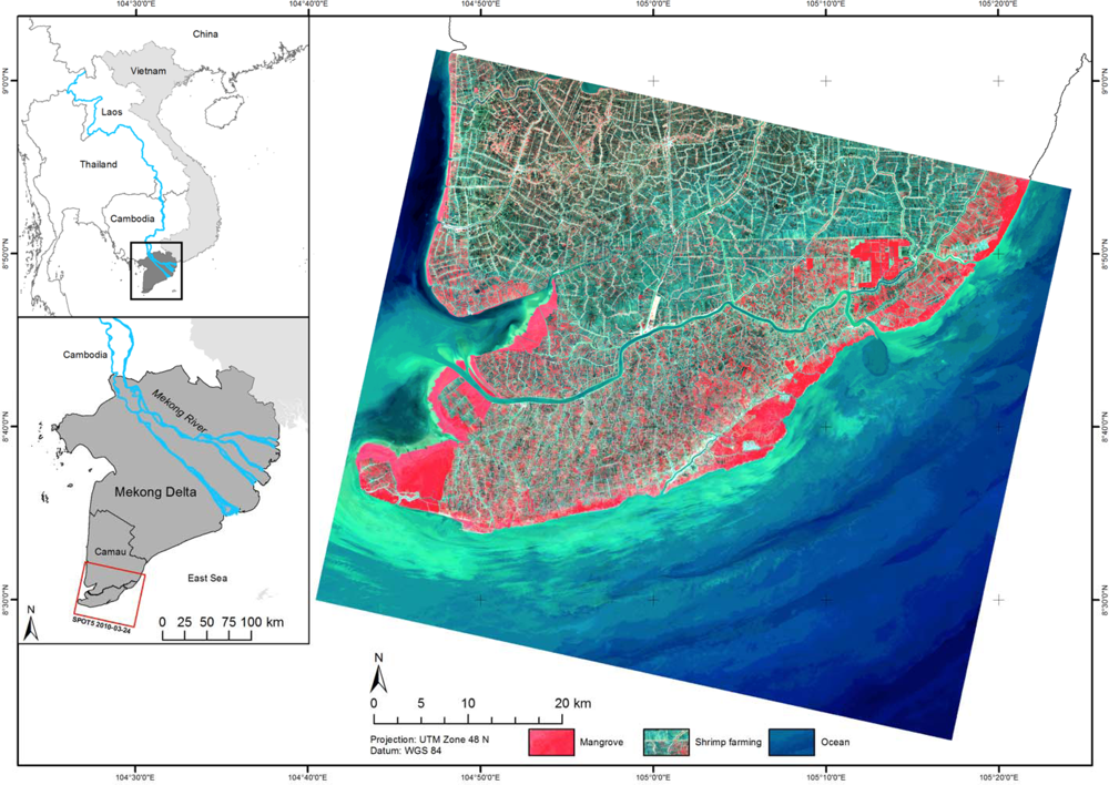
2. Study Area and Data
2.1. Study Area
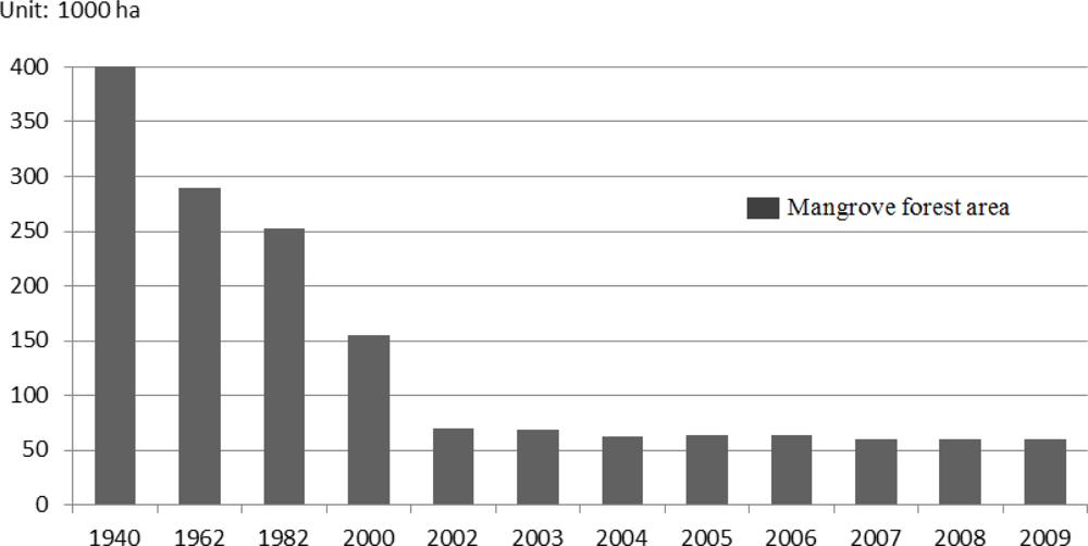
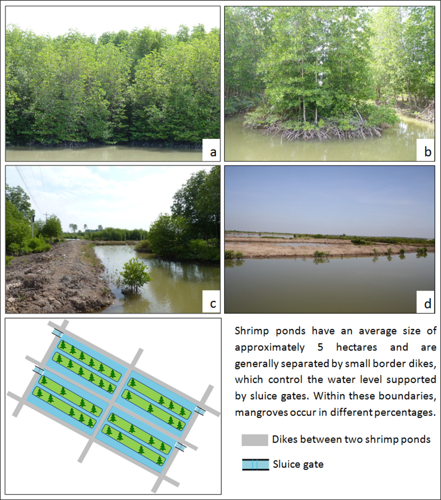
2.2. Mangrove Forest Management in Ca Mau
2.3. Data
3. Methodology
3.1. Preprocessing
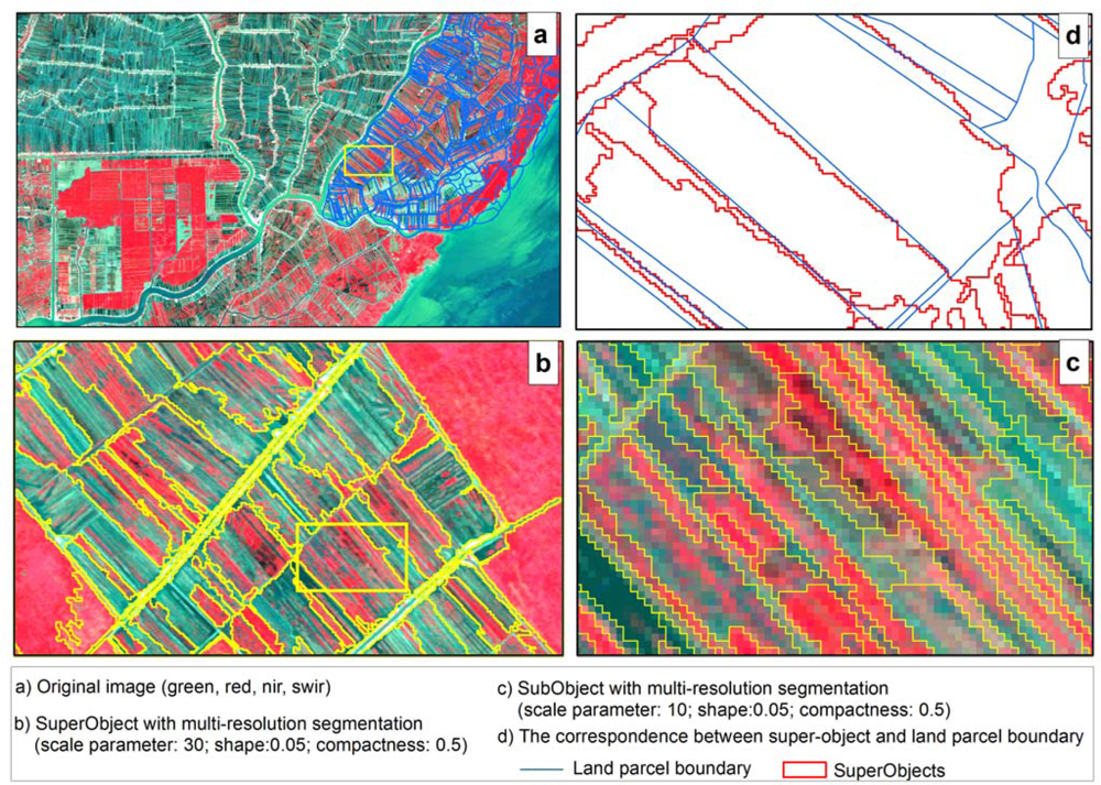
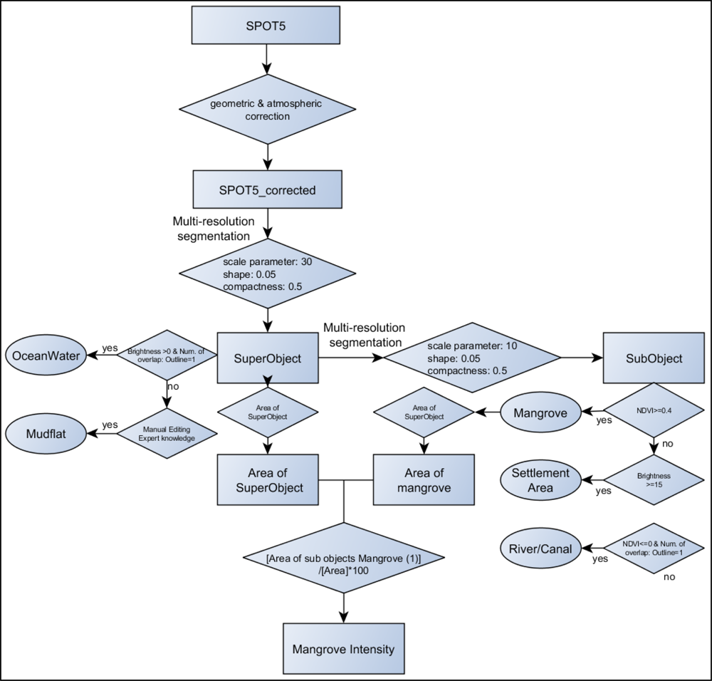
3.2. Image Segmentation
3.3. Classification
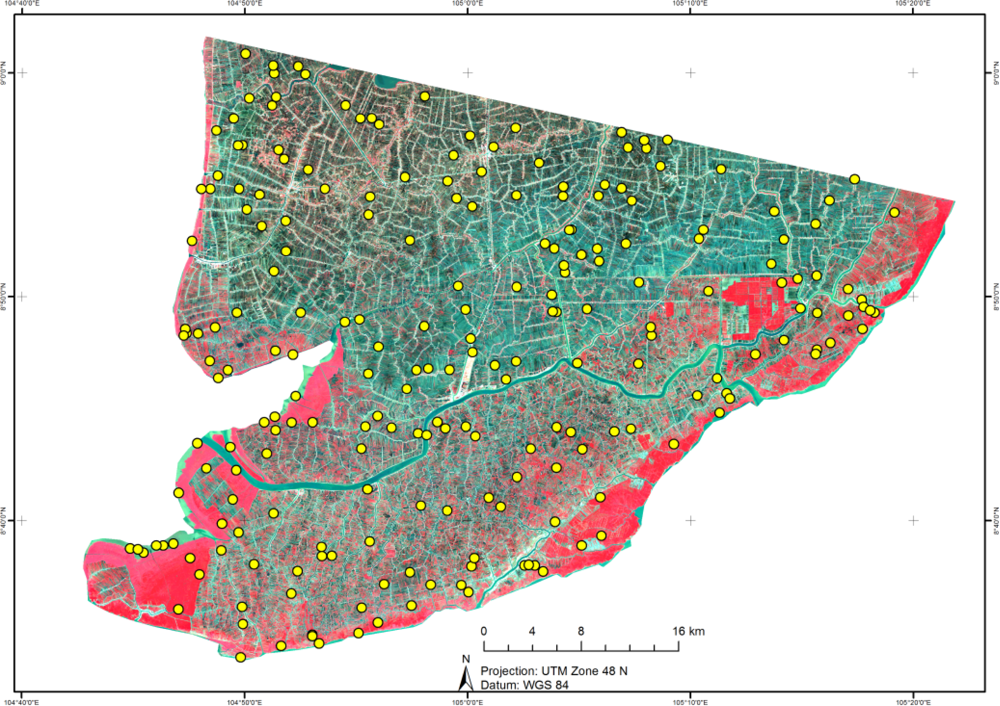
3.4. Validation
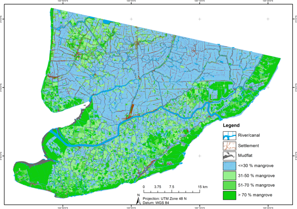
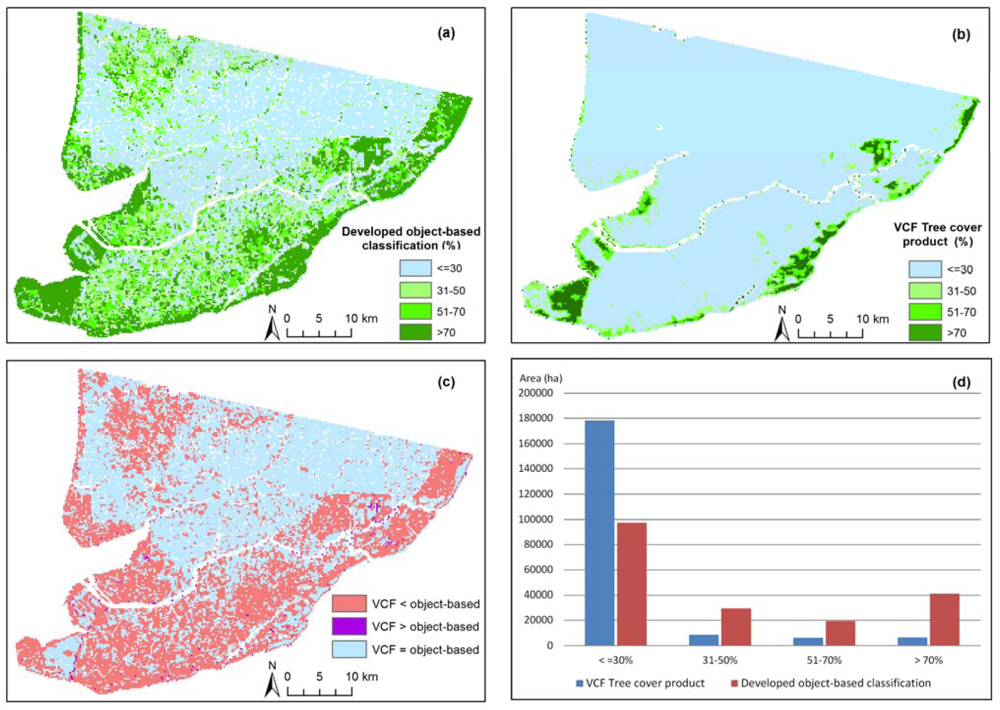
4. Results
5. Discussion
6. Conclusions
Acknowledgments
References
- Rönnbäck, P.; Rona, B.; Ingwall, L. The return of ecosystem goods and services in replanted mangrove forests—Perspectives from local communities in Gazi Bay, Kenya. Environ. Conserv 2007, 34, 313–324. [Google Scholar] [Green Version]
- Alongi, D.M. Present state and future of the world’s mangrove forests. Environ. Conserv 2002, 29, 331–349. [Google Scholar] [Green Version]
- Kathiresan, K.; Bingham, B.L. Biology of mangroves and mangrove ecosystems. Adv. Mar. Biol 2001, 40, 1–145. [Google Scholar] [Green Version]
- Vo, Q.T.; Kuenzer, C.; Vo, Q.M.; Moder, F.; Oppelt, N. Review of valuation methods for mangrove ecosystem services. Ecol. Indic 2012, 23, 431–446. [Google Scholar] [Green Version]
- Giri, C.; Muhlhausen, J. Mangrove forest distributions and dynamics in madagascar (1975–2005). Sensors 2008, 8, 2104–2117. [Google Scholar] [Green Version]
- Kuenzer, C.; Bluemel, A.; Gebhardt, S.; Quoc, T.V.; Dech, S. Remote sensing of mangrove ecosystems: A review. Remote Sens 2011, 3, 878–928. [Google Scholar] [Green Version]
- Thampanya, U.; Vermaat, J.E.; Sinsakul, S.; Panapitukkul, N. Coastal erosion and mangrove progradation of Southern Thailand. Estuar. Coast. Shelf Sci 2006, 68, 75–85. [Google Scholar] [Green Version]
- Hammer, M.; Holmlund, C.M.; Aqvist, M. Social-ecological feedback links for ecosystem management: A case study of fisheries in the Central Baltic Sea archipelago. Ocean Coast. Manag 2003, 46, 527–545. [Google Scholar] [Green Version]
- De Groot, R. A typology for the classification, description and valuation of ecosystem functions, goods and services. Ecol. Econ 2002, 41, 393–408. [Google Scholar] [Green Version]
- Ronnback, P.; Crona, B.; Ingwall, L. The return of ecosystem goods and services in replanted mangrove forests: Perspectives from local communities in Kenya. Environ. Conserv 2007, 34, 313–324. [Google Scholar] [Green Version]
- Seto, K.C.; Fragkias, M. Mangrove conversion and aquaculture development in Vietnam: A remote sensing-based approach for evaluating the Ramsar Convention on Wetlands. Glob. Environ. Change 2007, 17, 486–500. [Google Scholar] [Green Version]
- Badola, R.; Hussain, S.A. Valuing ecosystem functions: an empirical study on the storm protection function of Bhitarkanika mangrove ecosystem, India. Environ. Conserv 2005, 32, 85–92. [Google Scholar] [Green Version]
- Dahdouh-Guebas, F.; Jayatissa, L.P.; Di Nitto, D.; Bosire, J.O.; Lo Seen, D.; Koedam, N. How effective were mangroves as a defence against the recent tsunami? Curr. Biol 2005, 15, R443–7. [Google Scholar] [Green Version]
- Barbier, E.B. Natural barriers to natural disasters: replanting mangroves after the tsunami. Front. Ecol. Environ 2006, 4, 124–131. [Google Scholar] [Green Version]
- Gstaiger, V.; Huth, J.; Gebhardt, S.; Kuenzer, C. Multi-sensoral and automated derivation of inundated areas using TerraSAR-X and ENVISAT ASAR data. Int. J. Remote Sens 2012, 33, 37–41. [Google Scholar] [Green Version]
- Bann, C. The Economic Valuation of Tropical Forest Land Use Options: A Manual for Researchers; Economy and Environment Program for Southest Asia: Singapore, 1997. [Google Scholar]
- Walters, B.B.; Rönnbäck, P.; Kovacs, J.M.; Crona, B.; Hussain, S.A.; Badola, R.; Primavera, J.H.; Barbier, E.; Dahdouh-Guebas, F. Ethnobiology, socio-economics and management of mangrove forests: A review. Aquat. Bot 2008, 89, 220–236. [Google Scholar] [Green Version]
- Primavera, J.H. The values of wetlands: landscape and institutional development and conservation of Philippine mangroves: Institutional issues. Ecol. Econ 2000, 35, 91–106. [Google Scholar] [Green Version]
- Penha-Lopes, G.; Bartolini, F.; Limbu, S.; Cannicci, S.; Mgaya, Y.; Kristensen, E.; Paula, J. Ecosystem engineering potential of the gastropod Terebralia palustris (Linnaeus, 1767) in mangrove wastewater wetlands—A controlled mesocosm experiment. Environ. Pollut 2010, 158, 258–266. [Google Scholar] [Green Version]
- Rönnbäck, P. The ecological basis for economic value of seafood production supported by mangrove ecosystems. Ecol. Econ 1999, 29, 235–252. [Google Scholar] [Green Version]
- Costanza, R.; d’Arge, R.; De Groot, R.; Farber, S.; Grasso, M.; Hannon, B.; Limburg, K.; Naeem, S.; O’Neill, R.V.; Paruelo, J.; et al. The value of the world’s ecosystem services and natural capital. Nature 1997, 387, 253–260. [Google Scholar] [Green Version]
- Tue, N.T.; Ngoc, N.T.; Quy, T.D.; Hamaoka, H.; Nhuan, M.T.; Omori, K. A cross-system analysis of sedimentary organic carbon in the mangrove ecosystems of Xuan Thuy National Park, Vietnam. J. Sea Res 2012, 67, 69–76. [Google Scholar] [Green Version]
- Valiela, I.; Bowen, J.L.; York, J.K. Mangrove forests: One of the world’ s threatened major tropical environments. BioScience 2001, 51, 807–815. [Google Scholar] [Green Version]
- Alongi, D.M. Mangrove forests: Resilience, protection from tsunamis, and responses to global climate change. Estuar. Coast. Shelf Sci 2008, 76, 1–13. [Google Scholar] [Green Version]
- Barbier, E.; Cox, M. Economic and demographic factors affecting mangrove loss in the coastal provinces of Thailand, 1979–1996. Ambio 2002, 31, 351–357. [Google Scholar] [Green Version]
- Huth, J.; Kuenzer, C.; Wehrmann, T.; Gebhardt, S.; Tuan, V.Q.; Dech, S. Land cover and land use classification with TWOPAC: Towards automated processing for pixel- and object-based image classification. Remote Sens 2012, 4, 2530–2553. [Google Scholar] [Green Version]
- Kuenzer, C.; Renaud, F.G. Climate Change and Environmental Change in River Deltas Globally: Expected Impacts, Reilience, and Adaptation. In The Mekong Delta System—Interdisciplinary Analyses of a River Delta; Springer: Rotterdam, The Netherlands, 2012; pp. 7–48. [Google Scholar]
- Binh, T.N.K.; Vromant, N.; Hung, N.T.; Hens, L.; Boon, E.K. Land cover changes between 1968 and 2003 in Cai Nuoc, Ca Mau Peninsula, Vietnam. Area 2003, 7, 519–536. [Google Scholar] [Green Version]
- Green, E.P.; Cb, C.; Clark, C.D.; Mumby, P.J.; Edwards, A.J.; Ne, T.; Ellis, A.C. Remote sensing techniques for mangrove mapping. Int. J. Remote Sens 1998, 19, 935–956. [Google Scholar] [Green Version]
- Rasolofoharinoro, M.; Blasco, F. A remote sensing based methodology for mangrove studies in Madagascar. Int. J. Remote Sens 1998, 19, 1873–1886. [Google Scholar] [Green Version]
- Tong, P.H.S.; Auda, Y.; Populus, J.; Aizpuru, M.; Al Habshi, A.; Al Blasco, F. Assessment from space of mangroves evolution in the Mekong delta, in relation with extensive shrimp-farming. Int. J. Remote Sens 2004, 25, 4795–4812. [Google Scholar] [Green Version]
- Thu, P.M.; Populus, J. Status and changes of mangrove forest in Mekong Delta: Case study in Tra Vinh, Vietnam. Estuar. Coast. Shelf Sci 2007, 71, 98–109. [Google Scholar] [Green Version]
- Kamal, M.; Phinn, S. Hyperspectral data for mangrove species mapping: A comparison of pixel-based and object-based approach. Remote Sens 2011, 3, 2222–2242. [Google Scholar] [Green Version]
- Lee, T.; Yeh, H. Applying remote sensing techniques to monitor shifting wetland vegetation: A case study of Danshui River estuary mangrove communities, Taiwan. Ecol. Eng 2008, 5, 487–496. [Google Scholar] [Green Version]
- Béland, M.; Goïta, K.; Bonn, F.; Pham, T.T.H. Assessment of land-cover changes related to shrimp aquaculture using remote sensing data: A case study in the Giao Thuy District, Vietnam. Int. J. Remote Sens 2006, 27, 1491–1510. [Google Scholar] [Green Version]
- Hölbling, D.; Füreder, P.; Antolini, F.; Cigna, F.; Casagli, N.; Lang, S. A semi-automated object-based approach for landslide detection validated by persistent scatterer interferometry measures and landslide inventories. Remote Sens 2012, 4, 1310–1336. [Google Scholar] [Green Version]
- Polychronaki, A.; Gitas, I.Z. Burned area mapping in Greece using SPOT-4 HRVIR images and object-based image analysis. Remote Sens 2012, 4, 424–438. [Google Scholar] [Green Version]
- Polychronaki, A.; Gitas, I.Z. The development of an operational procedure for burned-area mapping using object-based classification and ASTER imagery. Int. J. Remote Sens 2010, 31, 1113–1120. [Google Scholar] [Green Version]
- Dupuy, S.; Barbe, E.; Balestrat, M. An object-based image analysis method for monitoring land conversion by artificial sprawl use of RapidEye and IRS data. Remote Sens 2012, 4, 404–423. [Google Scholar] [Green Version]
- Lamonaca, A.; Corona, P.; Barbati, A. Exploring forest structural complexity by multi-scale segmentation of VHR imagery. Remote Sens. Environ 2008, 112, 2839–2849. [Google Scholar] [Green Version]
- Conchedda, G.; Durieux, L.; Mayaux, P. An object-based method for mapping and change analysis in mangrove ecosystems. ISPRS J. Photogramm 2008, 63, 578–589. [Google Scholar] [Green Version]
- Wang, L.; Sousa, W.P.; Gong, P. Integration of object-based and pixel-based classification for mapping mangroves with IKONOS imagery. Int. J. Remote Sens 2004, 25, 5655–5668. [Google Scholar] [Green Version]
- Heumann, B.W. An object-based classification of mangroves using a hybrid decision tree—Support vector machine approach. Remote Sens 2011, 3, 2440–2460. [Google Scholar] [Green Version]
- Myint, S.W.; Giri, C.P.; Wang, L.; Zhu, Z.; Gillette, S.C. Identifying mangrove species and their surrounding land use and land cover classes using an object-oriented approach with a lacunarity spatial measure. GIScience Remote Sens 2008, 45, 188–208. [Google Scholar] [Green Version]
- Hay, G.J.; Castilla, G.; Wulder, M.A.; Ruiz, J.R. An automated object-based approach for the multiscale image segmentation of forest scenes. Int. J. Appl. Earth Obs. Geoinf 2005, 7, 339–359. [Google Scholar] [Green Version]
- Kuenzer, C.; Campbell, I.; Roch, M.; Leinenkugel, P.; Vo, Q.T.; Dech, S. Understanding the impacts of hydropower developments in the context of upstream-downstream relations in the Mekong River Basin. Sustainability Science 2012, 11, 1–20. [Google Scholar] [Green Version]
- Clough, B.; Tan, D.T.; Phuong, D.X.; Buu, D.C. Canopy leaf area index and litter fall in stands of the mangrove Rhizophora apiculata of different age in the Mekong Delta, Vietnam. Aquat. Bot 2000, 66, 311–320. [Google Scholar] [Green Version]
- Leinenkugel, P.; Esch, T.; Kuenzer, C. Settlement detection and impervious surface estimation in the Mekong Delta using optical and SAR remote sensing data. Remote Sens. Environ 2011, 115, 3007–3019. [Google Scholar] [Green Version]
- Evers, H.-D.; Benedikter, S. Strategic Group Formation in the Mekong Delta—The Development of a Modern Hydraulic Society. In ZEF Working Paper Series No 35; Center for Development Research (ZEF), University of Bonn: Bonn, Germany, 2009. [Google Scholar]
- Gebhardt, S.; Huth, J.; Nguyen, L.D.; Kuenzer, C. A comparison of TerraSAR-X Quadpol backscattering with RapidEye multispectral vegetation indices over rice fields in the Mekong Delta, Vietnam. Int. J. Remote Sens 2012, 33, 37–41. [Google Scholar] [Green Version]
- Goverment of Vietnam General Statistics Office. Available online: www.gso.gov.vn (accessed on 20 August 2012).
- Corps, C. Case Study 2: Mangrove Conservation vs. Shrimp Farming in Thailand. 2007, pp. 1–4. Available online: http://vancouveraccord.org/resources (accessed on 20 August 2012).
- Lebel, L.; Tri, N.H.; Saengnoree, A.; Pasong, S.; Buatama, U.; Thoa, L.K. Industrial transformation and shrimp aquaculture in Thailand and Vietnam: pathways to ecological, social, and economic sustainability? Ambio 2002, 31, 311–23. [Google Scholar] [Green Version]
- Government of Vietnam. Mangrove Forest Area. Available online: www.kiemlam.org.vn (accessed on 25 June 2011).
- Kovacs, J.M.; Flores-verdugo, F.; Wang, J.; Aspden, L.P. Estimating leaf area index of a degraded mangrove forest using high spatial resolution satellite data. Aquat. Bot 2004, 80, 13–22. [Google Scholar] [Green Version]
- Vaiphasa, C.; Ongsomwang, S.; Vaiphasa, T.; Skidmore, A.K. Tropical mangrove species discrimination using hyperspectral data: A laboratory study. Estuar. Coast. Shelf Sci 2005, 65, 371–379. [Google Scholar] [Green Version]
- Christensen, S.M.; Tarp, P.; Hjortsø, C.N. Mangrove forest management planning in coastal buffer and conservation zones, Vietnam: A multimethodological approach incorporating multiple stakeholders. Ocean Coast. Manag. 2008, 51, 712–726. Goverment of Vietnam. The Rule for Land Use and Natural Resource Utilization Based on the Decision No. 116/1999/QD-TTg of 3 March 1999 for Reforestation of Mangrove Forest in Ca Mau, Bac Lieu, Soc Trang and Tra Vinh Provinces. 1999; pp. 3–4. Available online: http://vbqppl.moj.gov.vn/vbpq/Lists/Vn%20bn%20php%20lut/View_Detail.aspx?ItemID=5538 (accessed on 25 June 2011). [Google Scholar] [Green Version]
- Richter, R.; Schläpfer, D. Atmospheric/Topographic Correction for Satellite Imagery; DLR Report DLR-IB 565-02/11; DLR: Wessling, Germany, 2011; p. 202. [Google Scholar]
- eCognition 8.7 Image Analysis Software. Trimble: Munich, Germany. Available online: http://www.ecognition.com/ (accessed on 25 June 2011).
- Baatz, M.; Benz, U.; Dehghani, S.; Heynen, M.; Astrid, H.; Hofmann, P.; Lingenfelder, I.; Mimler, M.; Sohlbach, M.; Weber, M.; Willhauck, G. User Guide 4—Introducing Ecognition Elements. 2004. Available online: www.gis.unbc.ca/help/software/ecognition4/ELuserguide.pdf (accessed on 25 June 2011).
- Baatz, M.; Schäpe, A. Multiresolution Segmentation: An Optimization Approach for High Quality Multi-Scale Image Segmentation. In Angewandte Geographische Informationsverarbeitung XII: Beiträge zum AGIT-Symposium Salzburg 2000 (German Edition); Strobl, J., Blaschke, T., Griesebner, G., Eds.; Wichmann-Verlag: Heidelberg, Germany, 2000; pp. 12–23. [Google Scholar]
- Congalton, R.; Green, K. Assessing the Accuracy of Remotely Sensed Data: Principles and Practices; CRC Press: Boca Raton, FL, USA, 2009; p. 183. [Google Scholar]
- Hansen, M.C.; Townshend, J.R.G.; DeFries, R.S.; Carroll, M. Estimation of tree cover using MODIS data at global, continental and regional/local scales. Int. J. Remote Sens 2005, 26, 4359–4380. [Google Scholar] [Green Version]
- Montesano, P.M.; Nelson, R.; Sun, G.; Margolis, H.; Kerber, a.; Ranson, K.J. MODIS tree cover validation for the circumpolar taiga–tundra transition zone. Remote Sens. Environ 2009, 113, 2130–2141. [Google Scholar] [Green Version]
- Ranson, K.J.; Montesano, P.M.; Nelson, R. Object-based mapping of the circumpolar taiga–tundra ecotone with MODIS tree cover. Remote Sens. Environ 2011, 115, 3670–3680. [Google Scholar] [Green Version]


| SPOT-5 (HRG) | |
|---|---|
| Band Wavelength (nm) | 480–710 (pan) |
| 500–590 (green) | |
| 610–680 (red) | |
| 790–890 (NIR) | |
| 1580–1750 (mid IR) | |
| Spatial Resolution (m) | 2.5 × 2.5 (pan) |
| 10 × 10 (multi) | |
| Swath Width (km) | 60 |
| Revisit Time (days) | 26 |
| Sensor | SPOT-5 MS |
|---|---|
| Date | 24.03.2010 |
| Solar zenith angle (deg) | 27.3 |
| Solar azimuth angle (deg) | 105.0 |
| Sensor tilt angle (deg) | 19.7 |
| Sensor view azimuth angle (deg) | 102.5 |
| Water vapor category | Tropical |
| Aerosol type | Maritime |
| Average visibility (km) | 80.0 |
| ≤30% | 31%–50% | 51%–70% | >70% | River-Canal | Mudflat | Settle-Ment | Producers Accuracy | Users Accuracy | |
|---|---|---|---|---|---|---|---|---|---|
| ≤30% | 62 | 11 | 5 | 0 | 1 | 0 | 2 | 89.86% | 76.54% |
| 31%–50% | 3 | 16 | 10 | 1 | 0 | 0 | 1 | 53.33% | 51.61% |
| 51%–70% | 2 | 1 | 14 | 3 | 0 | 0 | 3 | 42.42% | 60.87% |
| >70% | 1 | 2 | 4 | 32 | 0 | 0 | 1 | 86.49% | 80.00% |
| River-canal | 1 | 0 | 0 | 0 | 17 | 0 | 1 | 94.44% | 89.47% |
| Mudflat | 0 | 0 | 0 | 0 | 0 | 10 | 0 | 100.00% | 100.00% |
| Settlement | 0 | 0 | 0 | 1 | 0 | 0 | 17 | 68.00% | 94.44% |
Share and Cite
Vo, Q.T.; Oppelt, N.; Leinenkugel, P.; Kuenzer, C. Remote Sensing in Mapping Mangrove Ecosystems — An Object-Based Approach. Remote Sens. 2013, 5, 183-201. https://doi.org/10.3390/rs5010183
Vo QT, Oppelt N, Leinenkugel P, Kuenzer C. Remote Sensing in Mapping Mangrove Ecosystems — An Object-Based Approach. Remote Sensing. 2013; 5(1):183-201. https://doi.org/10.3390/rs5010183
Chicago/Turabian StyleVo, Quoc Tuan, Natascha Oppelt, Patrick Leinenkugel, and Claudia Kuenzer. 2013. "Remote Sensing in Mapping Mangrove Ecosystems — An Object-Based Approach" Remote Sensing 5, no. 1: 183-201. https://doi.org/10.3390/rs5010183
APA StyleVo, Q. T., Oppelt, N., Leinenkugel, P., & Kuenzer, C. (2013). Remote Sensing in Mapping Mangrove Ecosystems — An Object-Based Approach. Remote Sensing, 5(1), 183-201. https://doi.org/10.3390/rs5010183