Post-Fire Canopy Height Recovery in Canada’s Boreal Forests Using Airborne Laser Scanner (ALS)

Abstract
:1. Introduction
2. Material and Methods
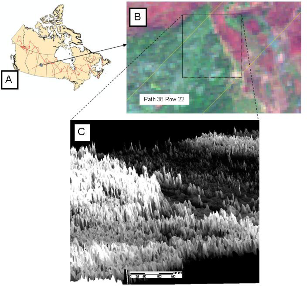
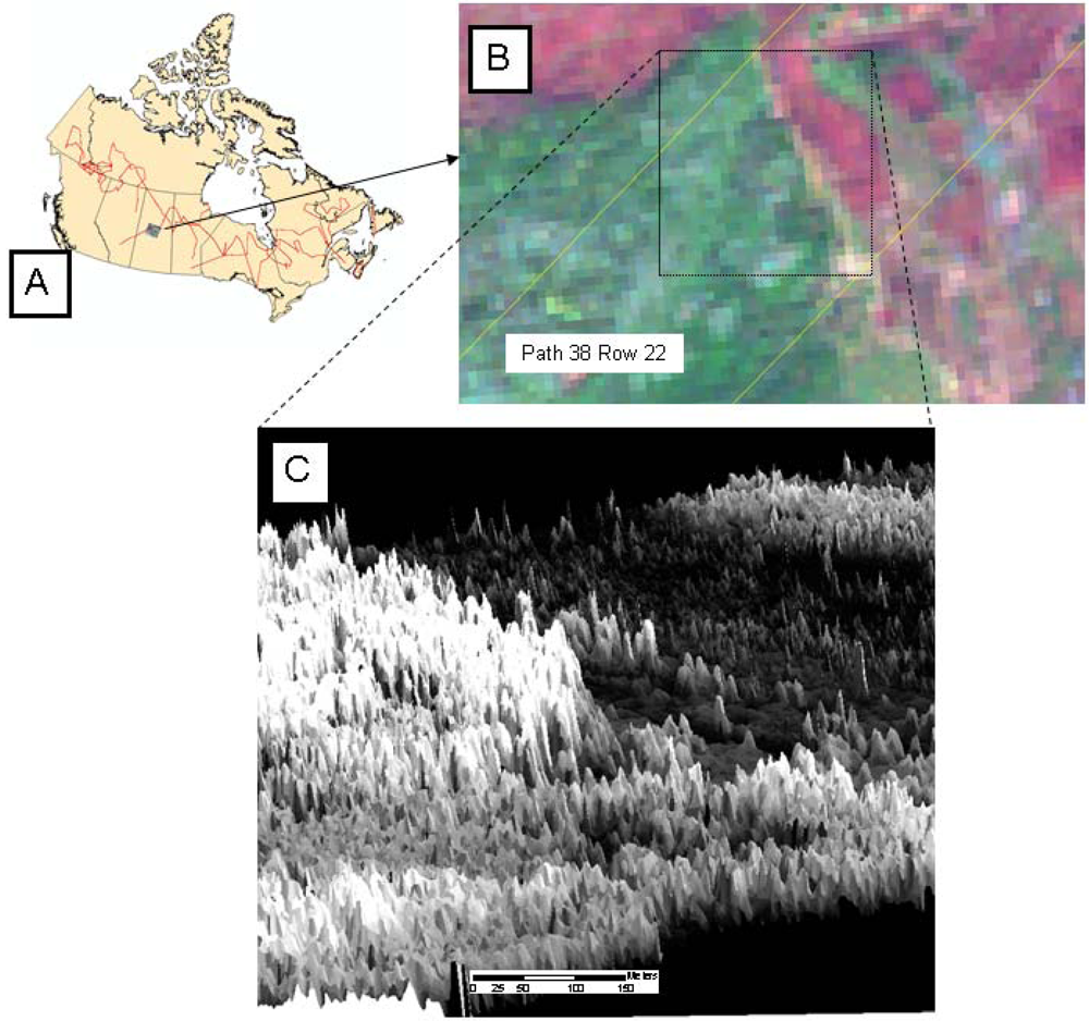
2.1. ALS Data Acquisition
2.2. ALS Data Processing
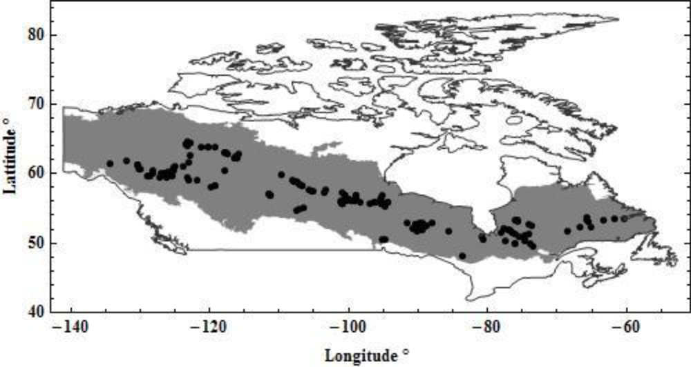
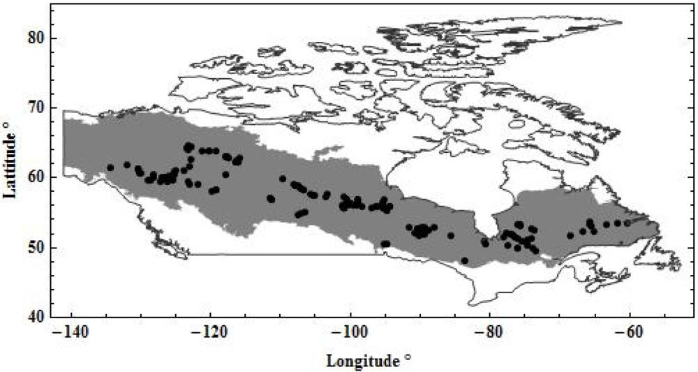
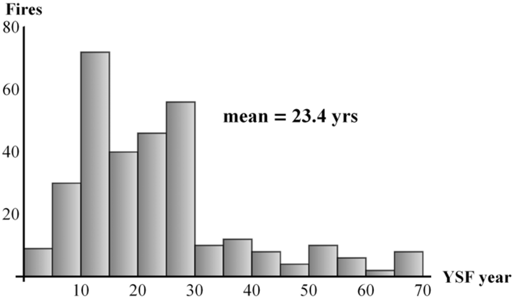
2.3. Fire Data
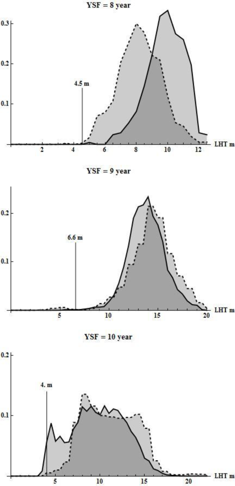
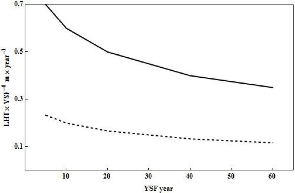
2.4. Estimating Post-Fire Tree Canopy Recovery
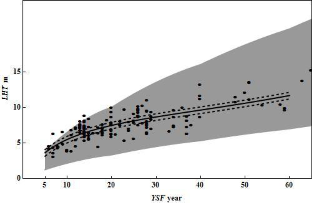
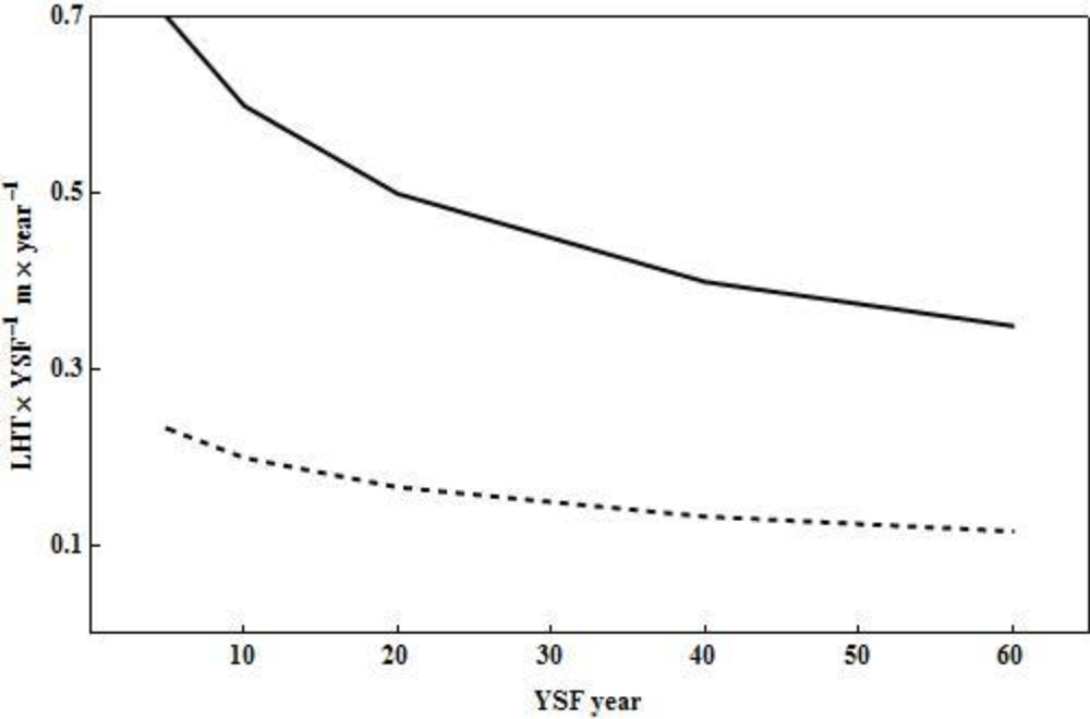
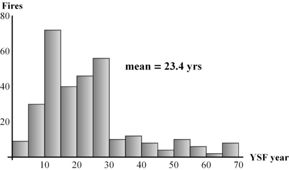
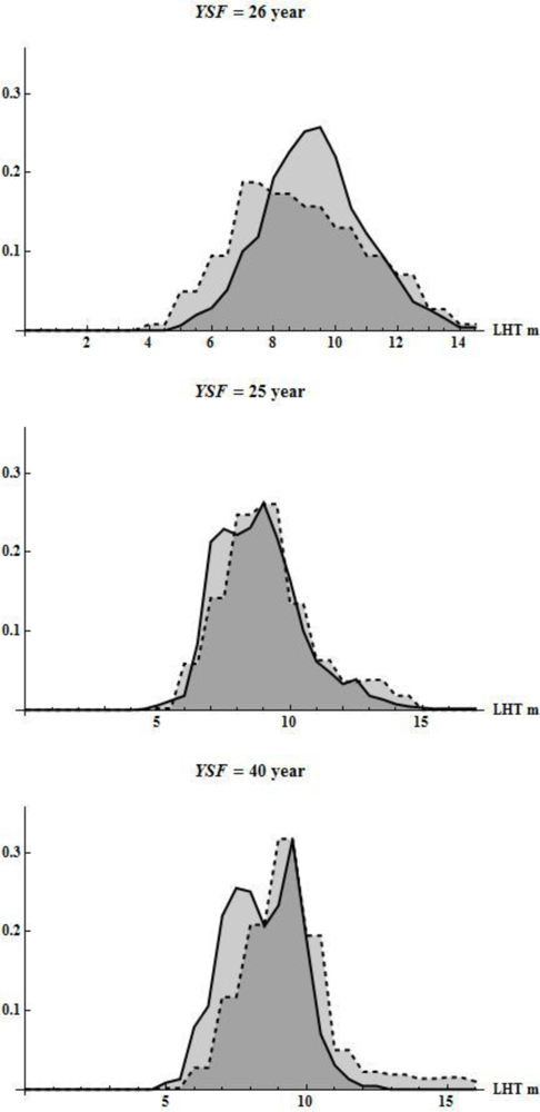
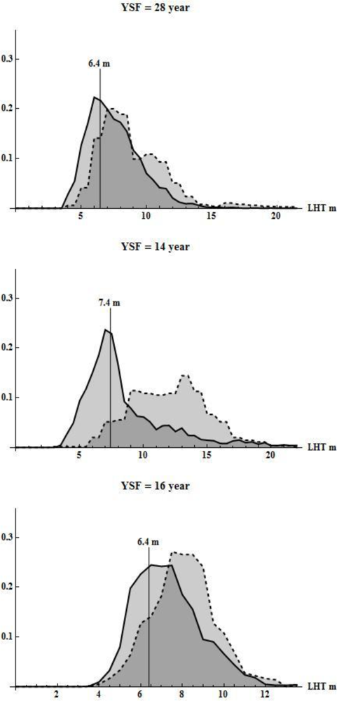
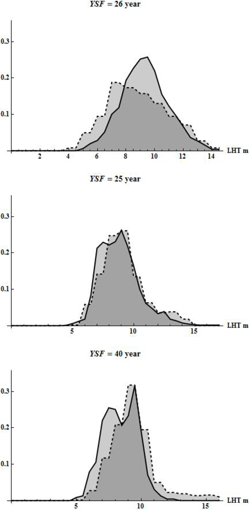
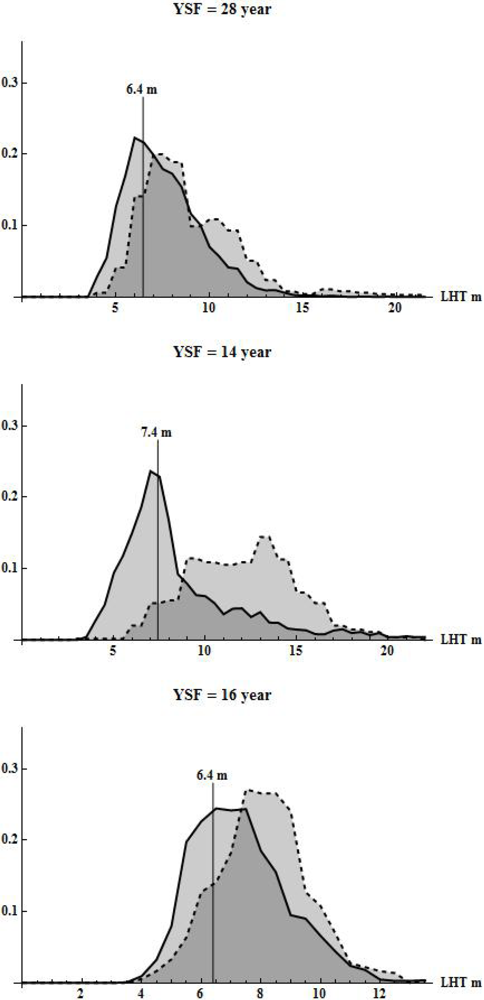
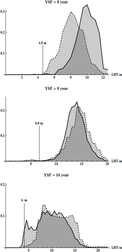
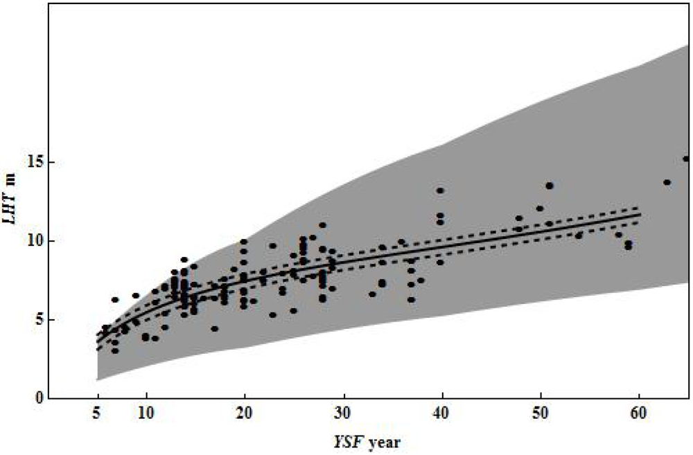
3. Results and Discussion
4. Conclusions
Acknowledgments
References
- Leckie, D.G.; Gillis, M.D. Forest inventory in canada with emphasis on map production. For. Chron 1995, 71, 74–78. [Google Scholar]
- Wulder, M.A.; Kurz, W.A.; Gillis, M. National level forest monitoring and modeling in Canada. Progr. Plan 2003, 61, 365–381. [Google Scholar]
- Gillis, M.D.; Omule, A.Y.; Brierley, T. Monitoring canada’s forests: The national forest inventory. For. Chron 2005, 81, 214–221. [Google Scholar]
- Wulder, M.A.; Seemann, D. Forest inventory height update through the integration of LIDAR data with segmented landsat imagery. Can. J. Remote Sens 2003, 29, 536–543. [Google Scholar]
- Næsset, E. Accuracy of forest inventory using airborne laser scanning: Evaluating the first nordic full-scale operational project. Scand. J. For. Res 2004, 19, 554–557. [Google Scholar]
- Hudak, A.T.; Evans, J.S.; Smith, A.M.S. Lidar utility for natural resource managers. Remote Sens 2009, 1, 934–951. [Google Scholar]
- Brandt, J.P. The extent of the north american boreal zone. Env. Rev 2009, 17, 101–161. [Google Scholar]
- Angelo, J.J.; Duncan, B.W.; Weishampel, J.F. Using LIDAR-derived vegetation profiles to predict time since fire in an oak scrub landscape in east-central florida. Remote Sens 2010, 2, 514–525. [Google Scholar]
- Morsdorf, F.; Meier, E.; Kotz, B.; Itten, K.I.; Dobbertin, M.; Allgower, B. Lidar-based geometric reconstruction of boreal type forest stands at single tree level for forest and wildland fire management. Remote Sens. Environ 2004, 92, 353–362. [Google Scholar]
- Listopad, C.M.C.S.; Drake, J.B.; Masters, R.E.; Weishampel, J.F. Portable and airborne small footprint LIDAR: Forest canopy structure estimation of fire managed plots. Remote Sens 2011, 3, 1284–1307. [Google Scholar]
- Tinker, D.; Stakes, G.K.; Arcano, R.M. Allometric equation development, biomass, and aboveground productivity in ponderosa pine forests, black hills, wyoming. W. J. Appl. For 2010, 25, 112–119. [Google Scholar]
- Nabuurs, G.J. Special section: European forest carbon balance as assessed with inventory based methods. For. Ecol. Manage 2010, 260, 239–240. [Google Scholar]
- García, M.; Riaño, D.; Chuvieco, E.; Danson, F.M. Estimating biomass carbon stocks for a mediterranean forest in central spain using LIDAR height and intensity data. Remote Sens. Environ 2010, 114, 816–830. [Google Scholar]
- De Santis, A.; Chuvieco, E. Burn severity estimation from remotely sensed data: Performance of simulation versus empirical models. Remote Sens. Environ 2007, 108, 422–435. [Google Scholar]
- Bond-Lamberty, B.; Peckham, S.D.; Ahl, D.E.; Gower, S.T. Fire as the dominant driver of central canadian boreal forest carbon balance. Nature 2007, 450, 89–92. [Google Scholar]
- Gaboury, S.; Boucher, J.-F.; Villeneuve, C.; Lord, D.; Gagnon, R. Estimating the net carbon balance of boreal open woodland afforestation: A case-study in Québec’s closed-crown boreal forest. For. Ecol. Manage 2009, 257, 483–494. [Google Scholar]
- Lhermitte, S.; Verbesselt, J.; Verstraeten, W.W.; Veraverbeke, S.; Coppin, P. Assessing intra-annual vegetation regrowth after fire using the pixel based regeneration index. ISPRS J. Photogramm 2011, 66, 17–27. [Google Scholar] [Green Version]
- Escuin, S.; Navarro, R.; Fernández, P. Fire severity assessment by using NBR (normalized burn ratio) and NDVI (normalized difference vegetation index) derived from Landsat TM/ETM images. Int. J. Remote Sens 2008, 29, 1053–1073. [Google Scholar]
- Murphy, K.A.; Reynolds, J.H.; Koltun, J.M. Evaluating the ability of the differenced normalized burn ratio (DNBR) to predict ecologically significant burn severity in alaskan boreal forests. Int. J. Wildland Fire 2008, 17, 490–499. [Google Scholar]
- Cocke, A.E.; Fulé, P.Z.; Crouse, J.E. Comparison of burn severity assessments using differenced normalized burn ratio and ground data. Int. J. Wildland Fire 2005, 14, 189–198. [Google Scholar]
- Nappi, A.; Drapeau, P.; Saint-Germain, M.; Angers, V.A. Effect of fire severity on long-term occupancy of burned boreal conifer forests by saproxylic insects and wood-foraging birds. Int. J. Wildland Fire 2010, 19, 500–511. [Google Scholar]
- Hély, C.; Flannigan, M.; Bergeron, Y. Modeling tree mortality following wildfire in the southeastern canadian mixed-wood boreal forest. For. Sci 2003, 49, 566–576. [Google Scholar]
- Beverly, J.L.; Martell, D.L. Modeling pinus strobus mortality following prescribed fire in quetico provincial park, north-western Ontario. Can. J. For. Res 2003, 33, 740–751. [Google Scholar]
- Martell, D.L. Wildfire regime in the boreal forest. Conserv. Biol 2002, 16, 1177. [Google Scholar]
- Jaskierniak, D.; Lane, P.N.J.; Robinson, A.; Lucieer, A. Extracting LIDAR indices to characterise multilayered forest structure using mixture distribution functions. Remote Sens. Environ 2011, 115, 573–585. [Google Scholar]
- van Leeuwen, M.; Nieuwenhuis, M. Retrieval of forest structural parameters using LIDAR remote sensing. Eur. J. For. Res 2010, 129, 749–770. [Google Scholar]
- Kane, V.R.; Bakker, J.D.; McGaughey, R.J.; Lutz, J.A.; Gersonde, R.F.; Franklin, J.F. Examining conifer canopy structural complexity across forest ages and elevations with LIDAR data. Can. J. For. Res 2010, 40, 774–787. [Google Scholar]
- Dalponte, M.; Bruzzone, L.; Gianelle, D. Tree species classification in the southern alps based on the fusion of very high geometrical resolution multispectral/hyperspectral images and LIDAR data. Remote Sens. Environ 2012, 123, 258–270. [Google Scholar]
- Hudak, A.T.; Strand, E.K.; Vierling, L.A.; Byrne, J.C.; Eitel, J.U.H.; Martinuzzi, S.; Falkowski, M.J. Quantifying aboveground forest carbon pools and fluxes from repeat LIDAR surveys. Remote Sens. Environ 2012, 123, 25–40. [Google Scholar]
- Evans, J.; Hudak, A.; Faux, R.; Smith, A.M. Discrete return LIDAR in natural resources: Recommendations for project planning, data processing, and deliverables. Remote Sens 2009, 1, 776–794. [Google Scholar]
- Treitz, P.; Lim, K.; Woods, M.; Pitt, D.; Nesbitt, D.; Etheridge, D. Lidar sampling density for forest resource inventories in ontario, canada. Remote Sens 2012, 4, 830–848. [Google Scholar]
- Axelsson, P. DEM generation from laser scanner data using adaptive TIN models. Int. Arch. Photogramm. Remote Sens. Spat. Inf. Sci 2000, 33, Part B4/1. 110–117. [Google Scholar]
- Wulder, M.A.; White, J.C.; Bater, C.W.; Coops, N.C.; Hopkinson, C.; Gang, C. Lidar plots—A new large-area data collection option: Context, concepts, and case study. Can. J. Remote Sens 2012. submitted.. [Google Scholar]
- Tinkham, W.T.; Huang, H.; Smith, A.M.S.; Shrestha, R.; Falkowski, M.J.; Hudak, A.T.; Link, T.E.; Glenn, N.F.; Marks, D.G. A comparison of two open source LIDAR surface classification algorithms. Remote Sens 2011, 3, 638–649. [Google Scholar]
- Meng, X.; Currit, N.; Zhao, K. Ground filtering algorithms for airborne LIDAR data: A review of critical issues. Remote Sens 2010, 2, 833–860. [Google Scholar]
- Sharma, M.; Paige, G.B.; Miller, S.N. DEM development from ground-based LIDAR data: A method to remove non-surface objects. Remote Sens 2010, 2, 2629–2642. [Google Scholar]
- Bater, C.W.; Coops, N.C. Evaluating error associated with LIDAR-derived DEM interpolation. Comput. Geosci 2009, 35, 289–300. [Google Scholar]
- McGaughey, R.J. Fusion/LDV: Software for Lidar Data Analysis and Visualization; Pacific Northwest Research Station, Forest Service, USDA: Portland, OR, USA, 2010. [Google Scholar]
- Næsset, E. Practical large-scale forest stand inventory using a small-footprint airborne scanning laser. Scand. J. For. Res 2004, 19, 164–179. [Google Scholar]
- Wulder, M.A.; White, J.C.; Cranny, M.; Hall, R.J.; Luther, J.E.; Beaudoin, A.; Goodenough, D.G.; Dechka, J.A. Monitoring Canada’s forests. Part 1: Completion of the eosd land cover project. Can. J. Remote Sens 2008, 34, 549–562. [Google Scholar]
- Wotton, B.M.; Nock, C.A.; Flannigan, M.D. Forest fire occurrence and climate change in canada. Int. J. Wildland Fire 2010, 19, 253–271. [Google Scholar]
- Stocks, B.J.; Mason, J.A.; Todd, J.B.; Bosch, E.M.; Wotton, B.M.; Amiro, B.D.; Flannigan, M.D.; Hirsch, K.G.; Logan, K.A.; Martell, D.L.; et al. Large forest fires in canada, 1959–1997. J. Geophys. Res 2003, 108, 8149. [Google Scholar]
- Oswald, E.T.; Brown, B.N. Vegetation Establishment during 5 Years Following Wildfire in Northern British Columbia and Southern Yukon Territory; BC-X-320; Forestry Canada: Victoria BC, Canada, 1990; p. 46. [Google Scholar]
- Anderson, K. A model to predict lightning-caused fire occurrences. Int. J. Wildland Fire 2002, 11, 163–172. [Google Scholar]
- Girardin, M.P.; Wotton, B.M. Summer moisture and wildfire risks across canada. J. Appl. Meteor. Climatol 2009, 48, 517–533. [Google Scholar]
- Hartigan, J.A.; Hartigan, P.M. The dip test of unimodality. Ann. Stat 1985, 13, 70–84. [Google Scholar]
- Silverman, B.W. Density Estimation for Statistics and Data Analysis; Chapman & Hall: London, UK, 1986; p. 175. [Google Scholar]
- Koenker, R. Quantile regression for longitudinal data. J. Multivar. Anal 2004, 91, 74–89. [Google Scholar]
- Boudewyn, P.; Song, X.; Magnussen, S.; Gillis, M.D. Model-Based, Volume-to-Biomass Conversion for Forested and Vegetated Land in Canada; BC-X-411; Canadian Forest Service, Natural Resources Canada: Victoria, BC, Canada, 2007; pp. 1–111. [Google Scholar]
- Efron, B.; Tibshirani, R.J. An Introduction to the Bootstrap; Chapman & Hall: Boca Raton, FL, USA, 1993; p. 436. [Google Scholar]
- Engle, R.F. Autoregressive conditional heteroscedasticity with estimates of the variance inflation. Econometrica 1982, 50, 987–1007. [Google Scholar]
- Beal, S.L. Sample size determination for confidence intervals on the population mean and on the difference between two population means. Biometrics 1989, 45, 969–977. [Google Scholar]
- Hartigan, J.A. Clustering Algorithms; Wiley: New York, NY, USA, 1975; p. 351. [Google Scholar]
- Bergeron, Y.; Gauthier, S.; Kafka, V.; Lefort, P.; Lesieur, D. Natural fire frequency for the eastern canadian boreal forest: Consequences for sustainable forestry. Can. J. For. Res 2001, 31, 384–391. [Google Scholar]
- Reed, W.J.; Johnson, E.A. Statistical methods for estimating historical fire frequency from multiple fire-scar data. Can. J. For. Res 2004, 34, 2306–2313. [Google Scholar]
- Leckie, D.; Gougeon, F.; Hill, D.; Quinn, R.; Armstrong, L.; Shreenan, R. Combined high-density LIDAR and multispectral imagery for individual tree crown analysis. Can. J. Remote Sens 2003, 29, 633–649. [Google Scholar]
- Burton, P.J.; Parisien, M.; Hicke, J.A.; Hall, R.J.; Freeburn, J.T. Large fires as agents of ecological diversity in the north american boreal forest. Int. J. Wildland Fire 2008, 17, 754–767. [Google Scholar]
- Allen, J.L.; Sorbel, B. Assessing the differenced normalized burn ratio’s ability to map burn severity in the boreal forest and tundra ecosystems of Alaska’s national parks. Int. J. Wildland Fire 2008, 17, 463–475. [Google Scholar]
- Eysn, L.; Hollaus, M.; Schadauer, K.; Pfeifer, N. Forest delineation based on airborne LIDAR data. Remote Sens 2012, 4, 762–783. [Google Scholar]
- Draper, N.R.; Smith, H. Applied Regression Analysis; Wiley: New York, NY, USA, 1981; p. 709. [Google Scholar]
- Hocking, R.R. The analysis and selection of variables in linear regression. Biometrics 1976, 32, 1–49. [Google Scholar]
- Domke, G.M.; Woodall, C.W.; Smith, J.E.; Westfall, J.A.; McRoberts, R.E. Consequences of alternative tree-level biomass estimation procedures on u.S. Forest carbon stock estimates. For. Ecol. Manage 2012, 270, 108–116. [Google Scholar]


| Step | Classification Rule (Test) | Classification of LHTin | Cases | Avg. Post-Fire Height Growth m × year−1 |
|---|---|---|---|---|
| 1 | YSF ≥ 25 and LH̄Tin ≤1.1LĤTQ95 and |LH̄Tin -LH̄Tout|< 1.2 m | Post-fire canopy | 34 | |
| 2 | LH̄Tin ≥ LH̄Tout + 1.2 m and LH̄Tin < 1.1LĤTQ95 | Partial post-fire canopy | 85 | |
| 3 | LH̄Tin ≥1.1LĤTQ95 | Pre-fire canopy | 16 |
| Step | Classification Rule (Test) | Classification of LHTin | Cases | Avg. Post-Fire Height Growth m × year−1 |
|---|---|---|---|---|
| Step 1 | LH̄Tin.1 ≤ LH̄Tout.1 and LH̄Tin.2 ≤ LH̄Tout.2 and LH̄Tin.1 ≤ LĤTQ95 and LH̄Tin.2 ≤ LĤTQ95 | Post-fire canopy | 1 | |
| Step 2 | LH̄Tin.1 ≤ LH̄Tout.1 and LH̄Tin.2 > LH̄Tout.2 LH̄Tin.1 ≤ LĤTQ95 | Partial post-fire canopy | 2 | |
| Step 3 | LH̄Tin.1 > LĤTQ95 | Pre-fire canopy | 16 |
Share and Cite
Magnussen, S.; Wulder, M.A. Post-Fire Canopy Height Recovery in Canada’s Boreal Forests Using Airborne Laser Scanner (ALS). Remote Sens. 2012, 4, 1600-1616. https://doi.org/10.3390/rs4061600
Magnussen S, Wulder MA. Post-Fire Canopy Height Recovery in Canada’s Boreal Forests Using Airborne Laser Scanner (ALS). Remote Sensing. 2012; 4(6):1600-1616. https://doi.org/10.3390/rs4061600
Chicago/Turabian StyleMagnussen, Steen, and Michael A. Wulder. 2012. "Post-Fire Canopy Height Recovery in Canada’s Boreal Forests Using Airborne Laser Scanner (ALS)" Remote Sensing 4, no. 6: 1600-1616. https://doi.org/10.3390/rs4061600