Use of Remote Sensing to Support Forest and Wetlands Policies in the USA


Abstract
:1. Introduction
2. US Policies Regarding Forests and Wetlands
2.1. Roads and Forests in the USA
2.1.1. Road Policies for the National Forests
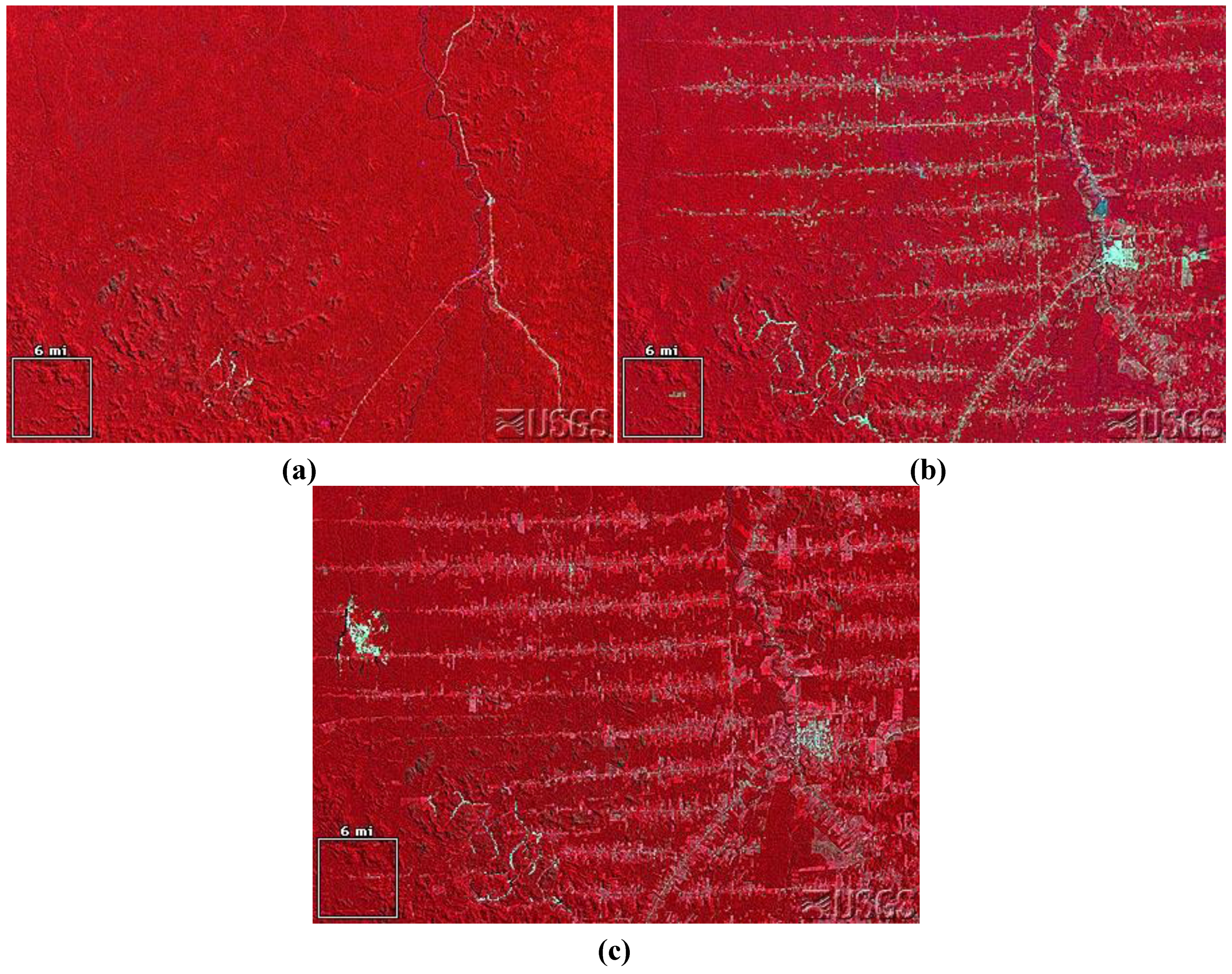
2.1.2. Road Detection in National Forests
2.2. Wetland Loss in the USA
2.2.1. Wetlands Conservation Policy
2.2.2. Remote Sensing and Wetlands at the National Scale
2.2.3. Regional-Scale Wetlands Programs Using Remote Sensing
Regional Use of the National Wetlands Inventory
3. Implementation Barriers
3.1. Emerging Opportunities for Policy Applications

3.2. Barriers to Use for Environmental Policy
4. Conclusions
Acknowledgements
References and Notes
- de Leeuw, J.; Georgiadou, Y.; Kerle, N.; de Gier, A.; Inoue, Y.; Ferwerda, J.; Smies, M.; Narantuya, D. The function of remote sensing in support of environmental policy. Remote Sens. 2010, 2, 1731–1750. [Google Scholar] [CrossRef]
- Backhaus, R.; Beule, B. Efficiency evaluation of satellite data products in environmental policy. Space Policy 2005, 21, 173–183. [Google Scholar] [CrossRef]
- Miller, R.B.; Small, C. Cities from space: Potential applications of remote sensing in urban environmental research and policy. Environ. Sci. Policy 2003, 6, 129–137. [Google Scholar] [CrossRef]
- Bryan, B.A.; Hajkowicz, S.; Marvanek, S.; Young, M.D. Mapping economic returns to agricultural for informing environmental policy in the Murray-Darling Basin, Australia. Environ. Model. Assess. 2009, 14, 375–390. [Google Scholar] [CrossRef]
- Koren, I.; Remer, L.A.; Longo, K. Reversal of trend of biomass burning in the Amazon. Geophys. Res. Lett. 2007, 34, L20404. [Google Scholar] [CrossRef]
- Baker, J.P.; Hulse, D.W.; Gregory, S.V.; White, D.; Van Sickle, J.; Berger, P.A.; Dole, D.; Schumaker, N.H. Alternative futures for the Willamette River Basin, Oregon. Ecol. Appl. 2004, 14, 313–324. [Google Scholar] [CrossRef]
- Engel-Cox, J.A.; Hoff, R.M. Science-policy data compact: Use of environmental monitoring data for air quality policy. Environ. Sci. Policy 2005, 8, 115–131. [Google Scholar] [CrossRef]
- Running, S.W.; Nemani, R.R.; Heinsch, F.A.; Zhao, M.; Reeves, M.; Hasimoto, H. A continuous satellite-derived measure of global terrestrial primary production. BioScience 2004, 54, 547–560. [Google Scholar] [CrossRef]
- Reid, W.V.; Chen, D.; Goldfarb, L.; Hackmann, H.; Lee, Y.T.; Mokhele, K.; Ostrom, E.; Raivio, K.; Rockström, J.; Schellnhuber, H.J.; Whyte, A. Earth system science for global sustainability: Grand challenges. Science 2010, 330, 916–917. [Google Scholar] [CrossRef] [PubMed]
- Molina, M.J.; Rowland, F.S. Stratospheric sink for chlorofluoromethands: Chlorine atom-catalysed destruction of ozone. Nature 1974, 249, 810–812. [Google Scholar] [CrossRef]
- NASA. Ozone Hole Watch. Available online: http://ozonewatch.gsfc.nasa.gov/ (accessed on 1 March 2011).
- United Nations Environment Programme, Ozone Secretariat. Handbook for the Montreal Protocol on Substances that Deplete the Ozone Layer, 7th ed.; 2006; Available online: http://ozone.unep.org/Publications/MP_Handbook/Section_1.1_The_Montreal_Protocol/ (accessed on 1 March 2011).
- Kampe, T.U.; Johnson, B.R.; Kuester, M.; Keller, M. NEON: The first continental-scale ecological observatory with airborne remote sensing of vegetation canopy biochemistry and structure. J. Appl. Remote Sens. 2010, 4, 043510. [Google Scholar] [CrossRef]
- Herold, M.; Woodcock, C.E.; Loveland, T.R.; Townshend, J.; Brady, M.; Steenmans, C.; Schmullius, C.C. Land-cover observations as part of a Global Earth Observation System of Systems (GEOSS): Progress, activities, and prospects. IEEE Syst. J. 2008, 2, 414–423. [Google Scholar] [CrossRef]
- Nativi, S.; Mazzetti, P.; Saarenmaa, H.; Kerr, J.; Tuama, É.Ó. Biodiversity and climate change use scenarios framework for the GEOSS interoperability pilot process. Ecol. Inform. 2009, 4, 23–33. [Google Scholar] [CrossRef]
- Stone, R. Earth-observation summit endorses global data sharing. Science 2010, 330, 902. [Google Scholar] [CrossRef] [PubMed]
- Christian, E. Planning for the Global Earth Observation System of Systems (GEOSS). Space Policy 2005, 21, 105–109. [Google Scholar] [CrossRef]
- Lautenbacher, C.C. The Global Earth Observation System of Systems: Science serving society. Space Policy 2006, 22, 8–11. [Google Scholar] [CrossRef]
- Group on Earth Observations Geo Portal: GEOSS online. Available online: http://www.earthobservations.org/index.html (accessed on 10 March 2011).
- Heilman, G.E., Jr.; Strittholt, J.R.; Slosser, N.C.; Dellasala, D.A. Forest fragmentation of the conterminous USA: Assessing forest intactness through road density and spatial characteristics. BioScience 2002, 52, 411–422. [Google Scholar] [CrossRef]
- Forman, R.T.T.; Sperling, D.; Bissonette, J.A.; Clevenger, A.P.; Cutshall, C.D.; Dale, V.H.; Fahrig, L.; France, R.L.; Goldman, C.R.; Heanue, K.; Jones, J.; Swanson, F.; Turrentine, T.; Winter, T.C. Road Ecology: Science and Solutions; Island Press: Washington, DC, USA, 2003. [Google Scholar]
- Coffin, A.W. From roadkill to road ecology: A review of the ecological effects of roads. J. Transp. Geogr. 2007, 15, 396–406. [Google Scholar] [CrossRef]
- Lugo, A.E.; Gucinski, H. Function, effects, and management of forest roads. Forest Ecol. Manag. 2000, 133, 249–262. [Google Scholar] [CrossRef]
- Gucinski, H.; Furniss, M.J.; Ziemer, R.R.; Brookes, M.H. Forest Roads: A Synthesis Of Scientific Information; General Technical Report PNW-GTR-509; Pacific Northwest Research Station, USDA Forest Service: Portland, OR, USA, 2001; p. 103. [Google Scholar]
- Forman, R.T.T.; Alexander, L.E. Roads and their major ecological effects. Ann. Rev. Ecol. Syst. 1998, 29, 207–231. [Google Scholar] [CrossRef]
- Eigenbrod, F.; Hecnar, S.J.; Fahrig, L. The relative effects of road traffic and forest cover on anuran populations. Biol. Conserv. 2008, 141, 35–46. [Google Scholar] [CrossRef]
- Laurance, W.F.; Williamson, G.B. Positive feedbacks among forest fragmentation, drought, and climate change in the Amazon. Conserv. Biol. 2001, 15, 1529–1535. [Google Scholar] [CrossRef]
- Hansen, M.J.; Clevenger, A.P. The influence of disturbance and habitat on the presence of non-native plant species along transport corridors. Biol. Conserv. 2005, 125, 249–259. [Google Scholar] [CrossRef]
- Riitters, K.H.; Wickham, J.D. How far to the nearest road? Front. Ecol. Environ. 2003, 1, 125–129. [Google Scholar] [CrossRef]
- Nie, M. Administrative rulemaking and public lands conflict: The Forest Service’s Roadless Rule. Nat. Resour. J. 2004, 44, 687–742. [Google Scholar]
- Voicu, M. At a dead end: The need for congressional direction in the roadless area management debate. Ecol. Law Quart. 2010, 37, 487–523. [Google Scholar]
- Glickman, D. 36 CFR Part 294, Special Areas; Roadless Area Conservation; Final Rule. In Federal Register; 12 January 2001; Volume 66, pp. 3244–3273. Available online: http://www.fs.usda.gov/Internet/FSE_DOCUMENTS/stelprdb5050459.pdf (accessed on 20 February 2011). [Google Scholar]
- Final Travel Management Regulations. In Federal Register; 9 November 2005; Volume 70, pp. 68264–68291.
- Cordell, H.K.; Betz, C.J.; Green, G.T.; Stephens, B. Off-Highway Vehicle Recreation in the USA and Its Regions and States: A National Report from the National Survey on Recreation and the Environment (NSRE); Internet Research Information Series; USDA Forest Service: Athens, GA, USA, 2008; Available online: http://www.fs.fed.us/recreation/programs/ohv/IrisRec1rpt.pdf (accessed on 25 February 2011).
- Werstak, C.; Johnson, V.; Maus, P.; Lachowski, H.; Merigliano, L.; Molyneux, M.; Meier, N. Geospatial Tools for Travel-Management Planning; RSAC-0063-RPT3; Remote Sensing Applications Center, USDA Forest Service: Salt Lake City, UT, USA, 2004. [Google Scholar]
- Williamson, M.; Evans, D.; Lachowski, H.; Lowery, L.; Clerke, W.; Meadows, D.; Watson, L. Technology Evaluation for Mapping Roads and Trails in the Ocala National Forest, Florida; RSAC-41-RPT1; Remote Sensing Applications Center, USDA Forest Service: Salt Lake City, UT, USA; San Dimas Technology and Development Center: San Dimas, CA, USA, 2002. [Google Scholar]
- Riitters, K.; Wickham, J.; Coulston, J. Use of road maps in national assessments of forest fragmentation in the USA. Ecol. Soc. 2004, 9, 13. [Google Scholar]
- Dahl, T.E. Wetland Losses in the USA, 1780’s to 1980’s; US Department of the Interior, Fish and Wildlife Service: Washington, DC, USA, 1990; p. 21.
- Dahl, T.E. Status and Trends of Wetlands in the Conterminous USA 1998 to 2004; US Department of the Interior, Fish and Wildlife Service: Washington, DC, USA, 2006; p. 112.
- Millennium Ecosystem Assessment. Ecosystems and Human Well-Being: Wetlands and Water Synthesis; World Resources Institute: Washington, DC, USA, 2005; p. 68. [Google Scholar]
- The Conservation Foundation. Protection America’s Wetlands: An Action Agenda, The Final Report of the National Wetlands Policy Forum; The Conservation Foundation: Washington, DC, USA, 1988; p. 69. [Google Scholar]
- Frayer, W.E.; Monahan, T.J.; Bowden, D.C.; Graybill, F.A. Status and Trends of Wetlands and Deepwater Habitats in the Conterminous USA, 1950’s to 1970’s; Colorado State University: Fort Collins, CO, USA, 1983; p. 32. [Google Scholar]
- Dahl, T.E.; Johnson, C.E. Status and Trends of Wetlands in the Conterminous USA, mid-1970’s to mid-1980’s; US Department of the Interior, Fish and Wildlife Service: Washington, DC, USA, 1991; p. 28.
- Dahl, T.E. Status and Trends of Wetlands in the Conterminous USA 1986 to 1997; US Department of the Interior, Fish and Wildlife Service: Washington, DC, USA, 2000; p. 82.
- Hall, J.V.; Frayer, W.E.; Wilen, B.O. Status of Alaska Wetlands; US Department of the Interior, Fish and Wildlife Service: Washington, DC, USA, 1994; p. 36.
- Alaska Department of Natural Resources. Alaska’s Outdoor Legacy: Statewide Comprehensive Outdoor Recreation Plan, 1992–1996; Department of Natural Resources, State of Alaska: Anchorage, AK, USA, 1993; p. 80.
- US Environmental Protection Agency, Ecosystem Services Research Program. Wetlands Research. Available online: http://www.epa.gov/ecology/quick-finder/wetlands-research.htm (accessed on 30 March 2011).
- US Army Corps of Engineers. Ecosystem Restoration. Available online: http://www.usace.army.mil/CECW/PlanningCOP/Pages/ecosystem.aspx (accessed on 30 March 2011).
- Ackleson, S.G.; Klemas, V. Remote sensing of submerged aquatic vegetation in lower Chesapeake Bay: A comparison of Landsat MSS to TM imagery. Remote Sens. Environ. 1987, 22, 235–248. [Google Scholar] [CrossRef]
- Sader, S.A.; Ahl, D.; Liou, W.S. Accuracy of Landsat-TM and GIS rule-based methods for forest wetland classification in Maine. Remote Sens. Environ. 1995, 53, 133–144. [Google Scholar] [CrossRef]
- Lo, C.P.; Watson, L.J. The influence of geographic sampling methods on vegetation map accuracy evaluation in a swampy environment. Photogramm. Eng. Remote Sensing 1998, 64, 1189–1200. [Google Scholar]
- Townsend, P.A.; Walsh, S.J. Remote sensing of forested wetlands: Application of multitemporal and multispectral satellite imagery to determine plant community composition and structure in southeastern USA. Plant Ecol. 2001, 157, 129–149. [Google Scholar] [CrossRef]
- Ozesmi, S.L.; Bauer, M. Satellite remote sensing of wetlands. Wetl. Ecol. Manag. 2002, 10, 381–402. [Google Scholar] [CrossRef]
- Bernthal, T.; Willis, K. Using Landsat 7 Imagery to Map Invasive Reed Canary Grass (Phalaris arundinacea): A Landscape Level Wetland Monitoring Methodology; Wisconsin Department of Natural Resources: Madison, WI, USA, 2004; p. 78. [Google Scholar]
- Wilen, B.O.; Bates, M.K. The US Fish and Wildlife Service’s National Wetland Inventory Project. Vegetatio 1995, 118, 153–169. [Google Scholar] [CrossRef]
- Ducks Unlimited. Updating the National Wetlands Inventory (NWI) for the Great Lakes (Wisconsin, Illinois, Indiana, Michigan, and Ohio) Project Workplan; Ducks Unlimited: Ann Arbor, MI, USA, 2008; p. 108. [Google Scholar]
- US Environmental Protection Agency. Chesapeake Bay Program: Implementation Plan; US Environmental Protection Agency: Annapolis, MD, USA, 1990; p. 42.
- Williams, D.J.; Rybicki, N.B.; Lombana, A.V.; O’Brien, T.M.; Gomez, R.B. Preliminary investigation of submerged aquatic vegetation mapping using hyperspectral remote sensing. Environ. Monit. Assess. 2003, 81, 383–392. [Google Scholar] [CrossRef]
- Werdell, P.J.; Bailey, S.W.; Franz, B.A.; Harding, L.W., Jr.; Feldman, G.C.; McClain, C.R. Regional and seasonal variability of chlorophyll-a in Chesapeake Bay as observed by SeaWiFS and MODIS-Aqua. Remote Sens. Environ. 2009, 113, 1319–1330. [Google Scholar] [CrossRef]
- Coastal Resources Management Council. Rhode Island Coastal and Estuarine Land Conservation Plan; Coastal Resources Management Council: Wakefield, RI, USA, 2010; p. 35.
- NOAA. Habitat Priority Planner. Available online: http://www.csc.noaa.gov/digitalcoast/tools/hpp/ (accessed on 25 March 2011).
- Quackenbush, L.J. A review of techniques for extracting linear features from imagery. Photogramm. Eng. Remote Sensing 2004, 70, 1383–1392. [Google Scholar] [CrossRef]
- Harvey, W.; McGlone, J.C.; McKeown, D.M.; Irvine, J.M. User-centric evaluation of semi-automated road network extraction. Photogramm. Eng. Remote Sensing 2004, 70, 1353–1364. [Google Scholar] [CrossRef]
- Priestnall, G.; Hatcher, M.J.; Morton, R.D.; Wallace, S.J.; Ley, R.G. A framework for automated extraction and classification of linear networks. Photogramm. Eng. Remote Sensing 2004, 70, 1373–1382. [Google Scholar] [CrossRef]
- Read, J.M.; Clark, D.B.; Venticinque, E.M.; Moreira, M.P. Application of merged 1-m and 4-m resolution satellite data to research and management in tropical forests. J. Appl. Ecol. 2003, 40, 592–600. [Google Scholar] [CrossRef]
- Wade, T.G.; Riitters, K.H.; Wickham, J.D.; Jones, K.B. Distribution and causes of global forest fragmentation. Conserv. Ecol. 2003, 7. article 7. [Google Scholar]
- Skole, D.; Tucker, C. Tropical deforestation and habitat fragmentation in the Amazon: Satellite data from 1978 to 1988. Science 1993, 260, 1905–1910. [Google Scholar] [CrossRef] [PubMed]
- Brandão, A.O., Jr.; Souza, C.M., Jr. Mapping unofficial roads with Landsat images: A new tool to improve the monitoring of the Brazilian Amazon rainforest. Int. J. Remote Sens. 2006, 27, 177–189. [Google Scholar] [CrossRef]
- Perz, S.; Brilhante, S.; Brown, F.; Caldas, M.; Ikeda, S.; Mendoza, E.; Overdevest, C.; Reis, V.; Reyes, J.F.; Rojas, D.; Schmink, M.; Souza, C.; Walker, R. Road building, land use and climate change: prospects for environmental governance in the Amazon. Phil. Trans. Roy. Soc. B 2008, 363, 1889–1895. [Google Scholar] [CrossRef] [PubMed]
- Camara, G.; Souza, R.C.M.; Freitas, U.M.; Garrido, J. SPRING: Integrating remote sensing and GIS by object-oriented data modeling. J. Comput. Graph. 1996, 20, 395–403. Available online: http://www.dpi.inpe.br/geopro/trabalhos/spring.pdf (accessed on 9 June 2011). [Google Scholar] [CrossRef]
- dos Santos Silva, M.P.; Câmara, G.; Escada, M.I.S.; de Souza, R.C.M. Remote-sensing image mining: Detecting agents of land-use change in tropical forest areas. Int. J. Remote Sens. 2008, 29, 4803–4822. [Google Scholar] [CrossRef]
- Campbell, R.W. Rondônia, Brazil: 1975, 1986, 1992. In Earthshots: Satellite Images of Environmental Change; USGS, 14 February 1997. Available online: http://earthshots.usgs.gov/Rondonia/Rondonia (accessed on 9 June 2011). [Google Scholar]
- Olander, L.P.; Gibbs, H.K.; Steininger, M.; Swenson, J.J.; Murray, B.C. Reference scenarios for deforestation and forest degradation in support of REDD: A review of data and methods. Environ. Res. Lett. 2008, 3, 025011. [Google Scholar] [CrossRef]
- Herold, M.; Johns, T. Linking requirements with capabilities for deforestation monitoring in the context of the UNFCCC-REDD process. Environ. Res. Lett. 2007, 2, 045025. [Google Scholar]
- Asner, G.P.; Powell, G.V.N.; Mascaro, J.; Knapp, D.E.; Clark, J.K.; Jacobson, J.; Kennedy-Bowdoin, T.; Balaji, A.; Paez-Acosta, G.; Victoria, E.; Secada, L.; Valqui, M.; Hughes, R.F. High-resolution forest carbon stocks and emissions in the Amazon. Proc. Natl. Acad. Sci. USA 2010, 107, 16738–16742. [Google Scholar] [CrossRef] [PubMed]
- Jha, A. Google unveils breakthrough technology to monitor deforestation. The Guardian, 10 December; 2009.
- Johnson, R.R.; Higgins, K.F. Wetland Resources of Eastern South Dakota, Brookings, SD; South Dakota State University: Brookings, SD, USA, 1997; p. 120. [Google Scholar]
- Sethre, P.R.; Rundquist, B.C.; Todhunter, P.E. Remote detection of prairie pothole ponds in the Devils Lake Basin, North Dakota. GIScience Remote Sens. 2005, 42, 277–296. [Google Scholar] [CrossRef]
- Winter, T.C.; Rosenberry, D.O. Hydrology of prairie wetlands during drought and deluge: A 17-year study of the Cottonwood Lake Wetland Complex in North Dakota in the perspective of longer term measured and proxy hydrological records. Climatic Change 1998, 40, 189–209. [Google Scholar] [CrossRef]
- Rundquist, D.; Lawson, M.; Queen, L.; Cerveny, R. The relationship between summer-season rainfall events and lake-surface area. Water Resour. Bull. 1987, 23, 493–508. [Google Scholar] [CrossRef]
- Harris, A.R. Time series remote sensing of a climatically sensitive lake. Remote Sens. Environ. 1994, 50, 83–94. [Google Scholar] [CrossRef]
- Birkett, C.M. Synergistic remote sensing of Lake Chad: Variability of basin inundation. Remote Sens. Environ. 2000, 72, 218–236. [Google Scholar] [CrossRef]
- Work, E.A., Jr.; Gilmer, D.S.; Klett, A. Utility of ERTS for Monitoring the Breeding Habitat of Migratory Waterfowl. In Proceedings of the Third Earth Resources Technology Satellite-1 Symposium, Washington, DC, USA, 10–14 December 1973; Volume 1, pp. 10–14.
- Work, E.A., Jr.; Gilmer, D.S. Utilization of satellite data for inventorying prairie ponds and lakes. Photogramm. Eng. Remote Sensing 1976, 42, 685–694. [Google Scholar]
- Best, R.G.; Moore, D.G. Landsat interpretation of prairie lakes and wetlands of eastern South Dakota in Satellite Hydrology. In Proceedings of the Fifth Annual William T. Pecora Memorial Symposium on Remote Sensing, Sioux Falls, SD, USA, 10–15 June 1979; Satellite Hydrology. Deutsch, M., Wiesnet, D.R., Rango, A., Eds.; American Water Resources Association: Minneapolis, MN, USA, 1981; pp. 499–506. [Google Scholar]
- Frazier, P.S.; Page, J.P. Water body detection and delineation with Landsat TM data. Photogramm. Eng. Remote Sensing 2000, 66, 461–1468. [Google Scholar]
- Adamus, P.R. Condition, Values, and Loss of Natural Functions of Prairie Wetlands of the North-Central USA; EPA/600/R-92/249; US Environmental Protection Agency: Washington, DC, USA, 1992. Available online: http://water.epa.gov/type/wetlands/assessment/appendixb.cfm#7.0 (accessed on 20 May 2011).
- Jones, K.B.; Neale, A.C.; Nash, M.S.; Van Remortel, R.D.; Wickham, J.D.; Ritters, K.H.; O’Neill, R.V. Predicting nutrient and sediment loadings to streams from landscape metrics: A multiple watershed study from the USA Mid-Atlantic Region. Landscape Ecol. 2001, 16, 301–312. [Google Scholar] [CrossRef]
- Kellogg, D.Q.; Golda, A.J.; Groffmanb, P.M.; Addya, K.; Stolta, M.H.; Blazejewski, G. In situ ground water denitrification in stratified, permeable soils underlying riparian wetlands. J. Environ. Qual. 2005, 34, 524–533. [Google Scholar] [CrossRef] [PubMed]
- Dosskey, M.G.; Helmers, M.J.; Eisenhauer, D.E. An approach for using soil surveys to guide the placement of water quality buffers. J. Soil Water Conserv. 2006, 61, 344–354. [Google Scholar]
- Vidon, P.G.F.; Hill, A.R. Landscape controls on nitrate removal in stream riparian zones. Water Resour. Res. 2004, 40, 2473–2487. [Google Scholar] [CrossRef]
- Baker, M.E.; Weller, D.E.; Jordan, T.E. Improved methods for quantifying potential nutrient interception by riparian buffers. Landscape Ecol. 2006, 21, 1327–1345. [Google Scholar] [CrossRef]
- Dodds, W.K.; Oakes, R.M. Headwater influences on downstream water quality. Environ. Manag. 2008, 41, 367–377. [Google Scholar] [CrossRef] [PubMed]
- Tomer, M.D.; Dosskey, M.G.; Burkhart, M.R.; James, D.E.; Helmers, M.J.; Eisenhauer, D.E. Methods to prioritize placement of riparian buffers for improved water quality. Agroforest. Syst. 2009, 75, 17–25. [Google Scholar] [CrossRef]
- Ebert, D.W.; Wade, T.G. Analytical Tools Interface for Landscape Assessments (ATtiLA): User Manual; EPA/600/R-04/083; US Environmental Protection Agency: Washington, DC, USA, 2004; p. 39.
- Macauley, M.K. The value of information: Measuring the contribution of space-derived earth science data to resource management. Space Policy 2006, 22, 274–282. [Google Scholar] [CrossRef]
- Kalser, J.V.; Stow, D.A.; Cao, L. Evaluation of remote sensing techniques for mapping transborder trails. Photogramm. Eng. Remote Sensing 2004, 70, 1441–1447. [Google Scholar]
- Rivero, R.G.; Grunwald, S.; Binford, M.W.; Osborne, T.Z. Integrating spectral indices into functional models to predict soil phosphorus in a subtropical wetland. Remote Sens. Environ. 2009, 113, 2389–2402. [Google Scholar] [CrossRef]
- Comprehensive Everglades Restoration Program; Florida Department of Environmental Protection: Tallahassee, FL, USA. Available online: http://www.dep.state.fl.us/water/wqssp/everglades/cerp.htm (accessed on 25 March 2011).
- Northern Everglades and Estuaries Protection Program; Florida Department of Environmental Protection: Tallahassee, FL, USA. Available online: http://www.sfwmd.gov/portal/page/portal/xweb%20protecting%20and%20restoring/other%20everglades (accessed on 25 March 2011).
- Migratory Bird Program; US Fish and Wildlife Service: Arlington, VA, USA. Available online: http://www.fws.gov/migratorybirds/regulationspolicies/mbta/mbtintro.html (accessed on 15 May 2011).
- International Affairs: International Wetlands Program; US Fish and Wildlife Service: Arlington, VA, USA. Available online: http://www.fws.gov/international/dic/global/wetlands.html (accessed on 15 May 2011).
© 2011 by the authors; licensee MDPI, Basel, Switzerland. This article is an open access article distributed under the terms and conditions of the Creative Commons Attribution license (http://creativecommons.org/licenses/by/3.0/).
Share and Cite
Mayer, A.L.; Lopez, R.D. Use of Remote Sensing to Support Forest and Wetlands Policies in the USA. Remote Sens. 2011, 3, 1211-1233. https://doi.org/10.3390/rs3061211
Mayer AL, Lopez RD. Use of Remote Sensing to Support Forest and Wetlands Policies in the USA. Remote Sensing. 2011; 3(6):1211-1233. https://doi.org/10.3390/rs3061211
Chicago/Turabian StyleMayer, Audrey L., and Ricardo D. Lopez. 2011. "Use of Remote Sensing to Support Forest and Wetlands Policies in the USA" Remote Sensing 3, no. 6: 1211-1233. https://doi.org/10.3390/rs3061211
APA StyleMayer, A. L., & Lopez, R. D. (2011). Use of Remote Sensing to Support Forest and Wetlands Policies in the USA. Remote Sensing, 3(6), 1211-1233. https://doi.org/10.3390/rs3061211