4.1. Volumetric Analysis
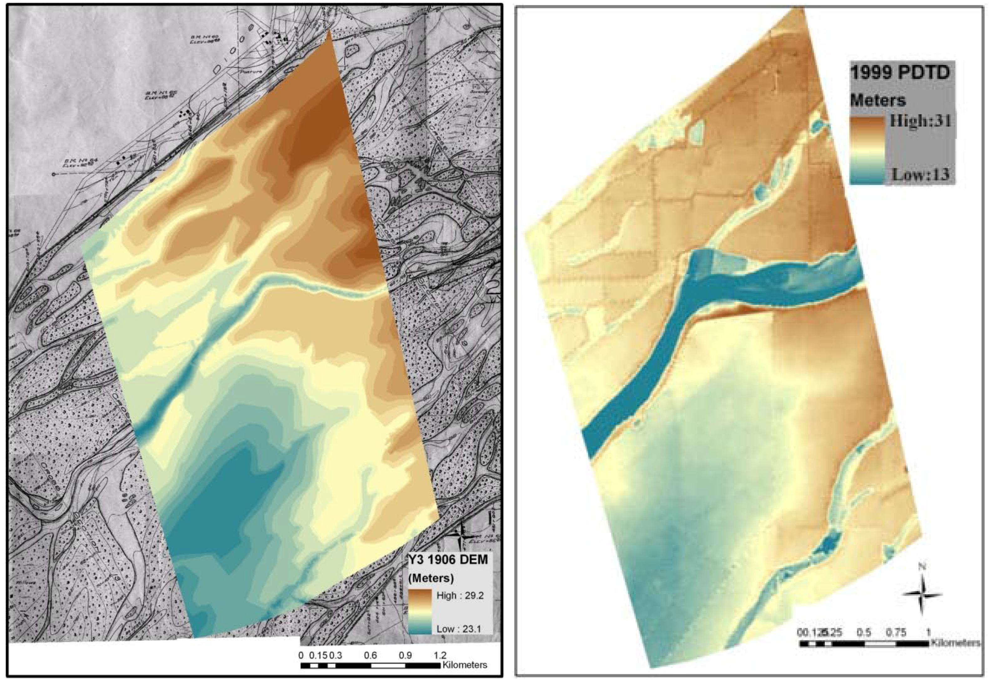
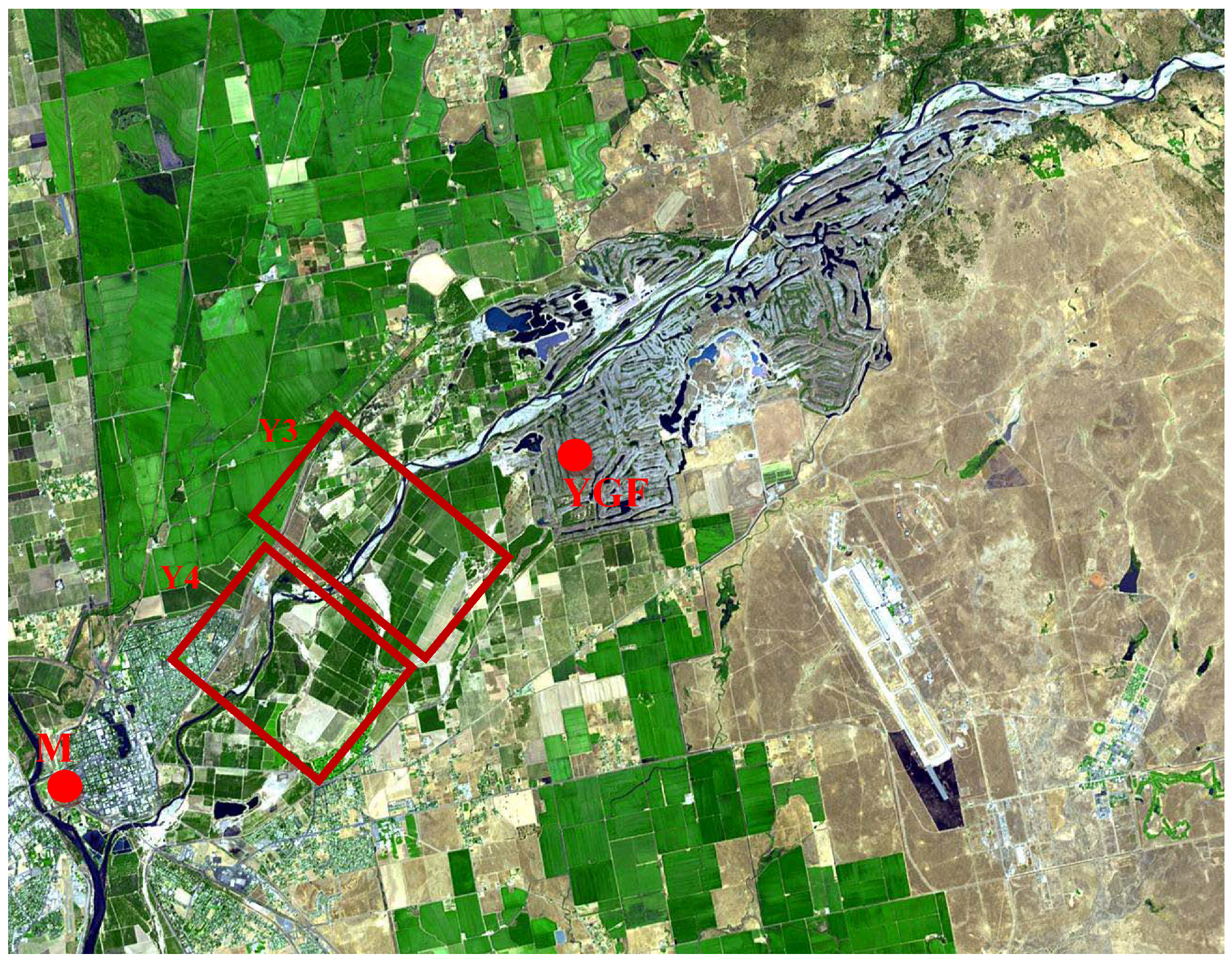
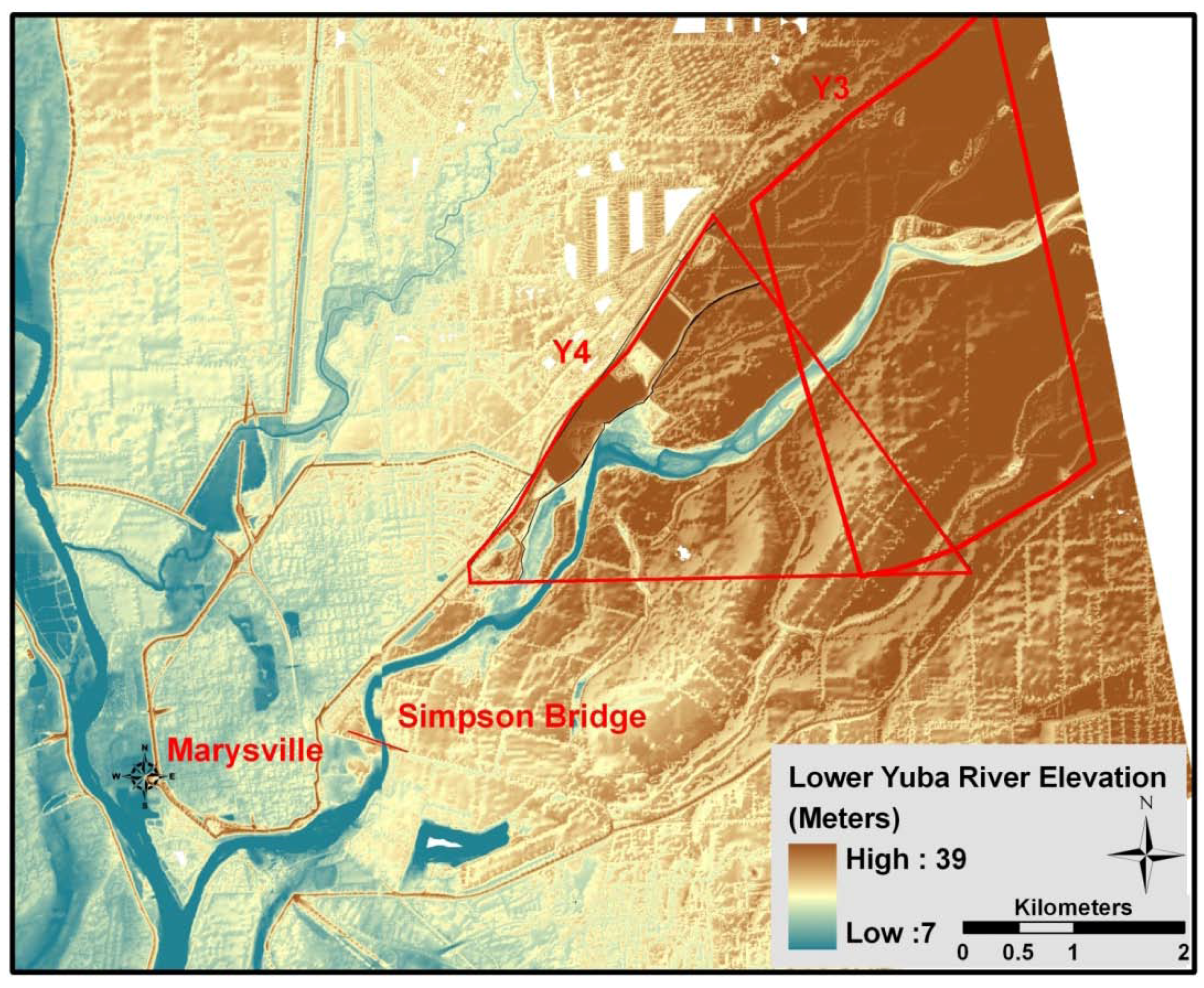
The CDC (1906) maps show detailed topography of the channel, floodplain, and terrace surfaces. The main channel position at these two sites, digitized from a 1999 DOQQ, corresponds fairly closely with the 1906 low-water channel position indicating that the channel largely returned to its original position in this part of the lower Yuba [
18]. Channel scars on the 1906 maps represent pre-1906 channel positions during the period of mining. The largest of these high-water channels remain active during large floods. The volumetric analysis reveals that erosion dominated at both Yuba River sites from 1906 to 1999. Total volumetric erosion at the Y3 site was 5.6 × 10
6 m
3 while the total volumetric deposition was 3.9 × 10
6 m
3 (
Table 1). The maximum amount of erosion was from the channel bed followed by bars and terraces. On the basis of the two dates of the volumetric analysis, it is not possible to further constrain when these changes occurred.
In a broad sense, the volumetric change data are best described in two distinct systems: the main channel
versus the terraces (historical floodplains). No deposition occurred in the positions of modern main channels, which were dominated by deep incision, in some areas more than 10 m (
Figure 10 and
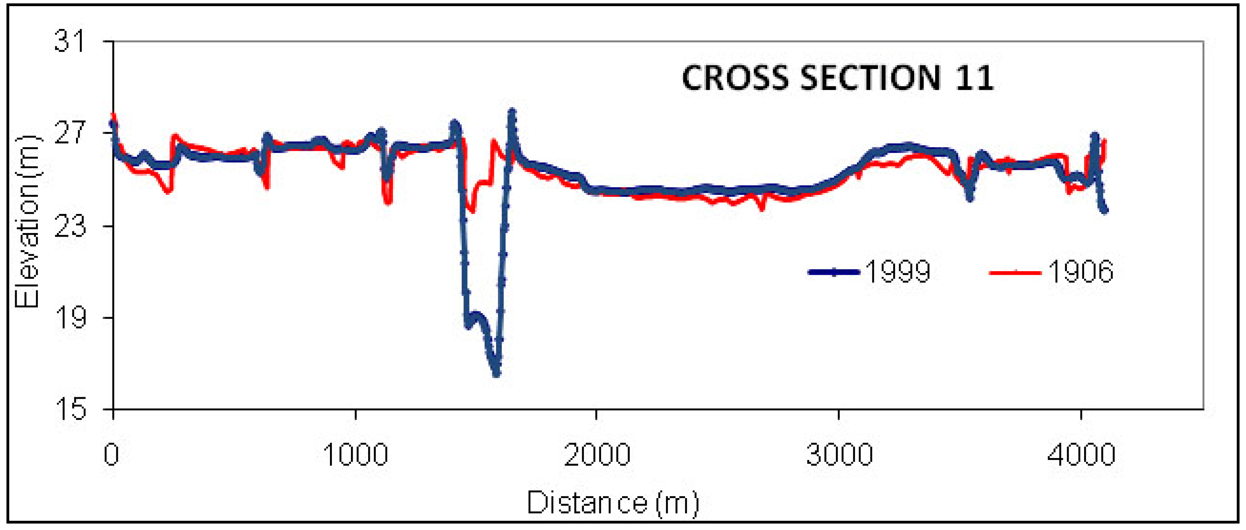
Figure 11). For example, the deepest point in the channel through the Y3 reach is at an elevation of 26.8 m above m.s.l. on the 1906 map, but the deepest point is twelve meters lower at only 14.8 m above m.s.l. when the 1999 SONAR data were collected. Similarly, cross-section analysis (
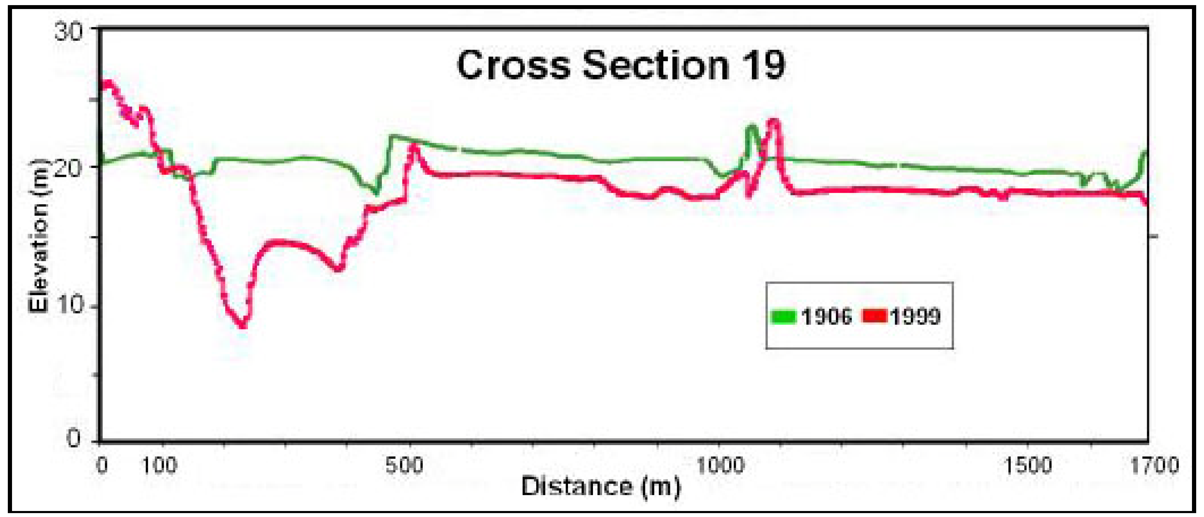
Figure 8) shows that the 1999 channel incised more than 12 m along cross section 11 after 1906. The greatest elevation decreases occurred where the modern thalweg has eroded into relatively high terraces composed of historical mining sediment deposited during the peak period of channel aggradation. At these locations, terrace scarps may exceed 10 m in height and lateral connectivity between the low-flow channel and adjacent alluvial land has been largely disrupted.
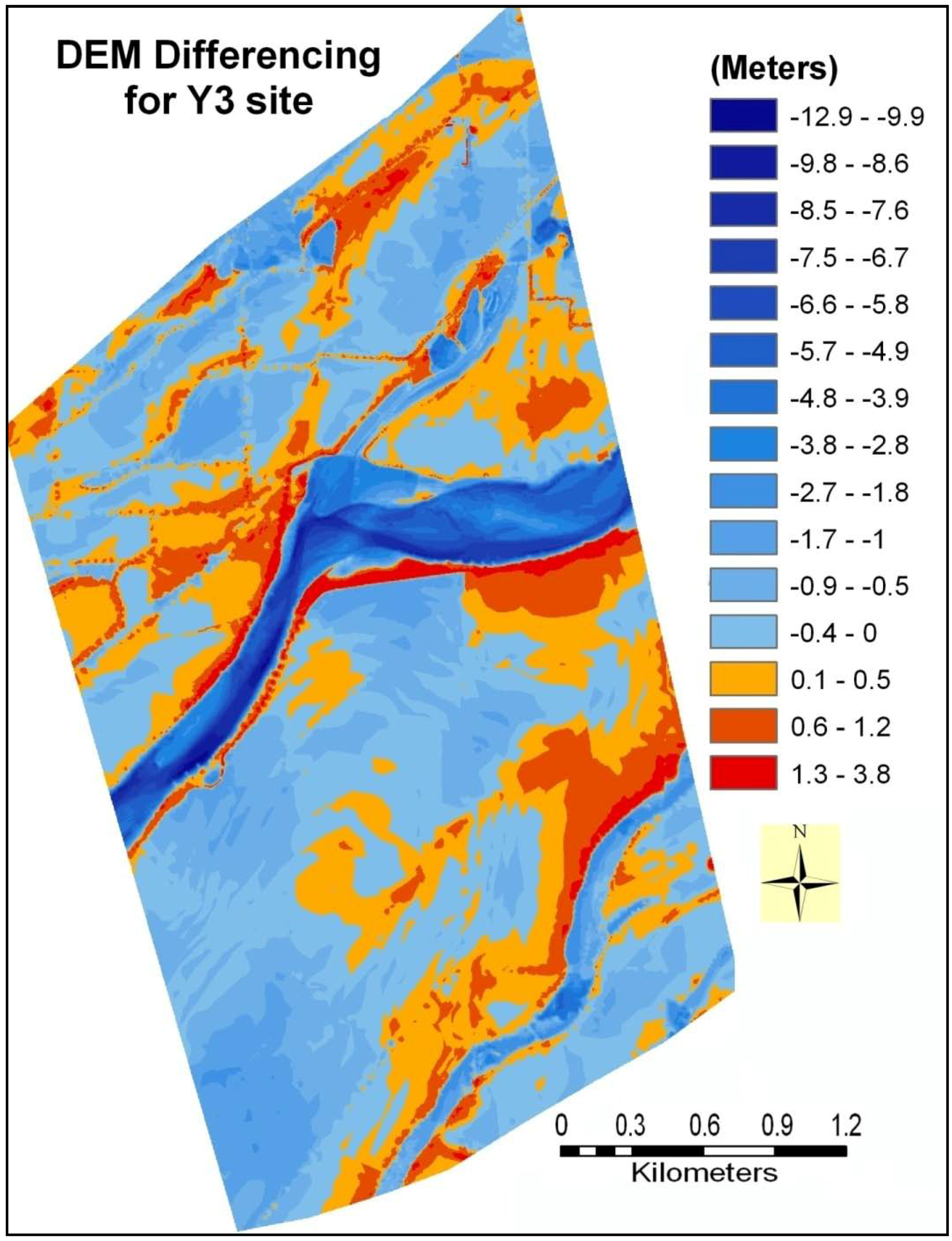
Outside of the main channels, changes from 1906 to 1999 were dominated by morphologic adjustments within and along the major high-water channels representing former large channels south of the modern main channel. The high-water channels generally incised one or two meters from 1906 to 1999; far less than the modern main channels. Some isolated points along the high-water channel in the Y3 reach were up to 5 m lower in 1999 than in 1906 (
Figure 10), but field visits indicate that these depressions represent local sand quarries. Most sediment deposition in the study area was on terraces;
i.e., historical floodplains now perched 6 to 10 m above the main channel but flooded by decadal flood events. Terrace deposits primarily formed as large natural levees adjacent to the high-water channels sometime after 1906, representing a large volume of sediment storage. Overbank sedimentation on natural levees was important during the recovery period along the larger high-water channels as well as the main channel. A logical inference from the dominance of natural levees as depositional sites is that overbank sediment was relatively coarse grained (sandy) and remained close to channel sources. Similar processes have been noted on the Sacramento River at Fremont Weir [
29]. Construction of natural levees represents a major redistribution of historical sediment storage from the inner channel, which incised deeply, to floodplains adjacent to major flood channels. Away from channels, broad areas of floodplain surface show a relatively uniform vertical lowering, largely less than 1 m (
Figure 10 and
Figure 11). Floodplains do not generally erode to such uniform depths, so this may represent compaction of the deep historical deposits, subsidence owing to groundwater extractions, or an artifact of vertical registration.
No deposition occurred in the main high-water channels over the 1906 to 1999 period. Absence of deposition in these channels from 1906 to 1999 raises the question why they are not filling by overbank accretion processes which is typical of abandoned channels on actively inundated floodplains with abundant sediment. The explanation may be that the poor time resolution (1906 to 1999) of the volumetric analysis fails to capture recent filling episodes. Channel incision was likely most active during the early 20th century, and by differencing DEMs over such a long time period, the analysis cannot detect a late period of channel filling of a lower magnitude than the earlier incision. The volumetric results only show the net sediment change on the floodplain for a 93 year period. The total net change in sediment volume from the Y3 site is 1.7 × 10
6 m
3 for the period between 1906 and 1999, but this masks the active relocation of larger sediment volumes including 5.6 × 10
6 m
3 eroded and 3.9 × 10
6 m
3 deposited (
Table 1).
Table 1.
Volumetric changes from 1906 to 1999 at Y3.
Table 1.
Volumetric changes from 1906 to 1999 at Y3.
| | Erosion (m3) | Deposition (m3) | Net Change (m3) |
|---|
| Channels | −1,935,044 | 0 | −1,935,044 |
| Bars | −1,694,310 | 937,038 | −757,272 |
| High-water channels | −564,605 | 0 | −564,605 |
| Terraces | −1,452,474 | 2,994,265 | 1,541,791 |
| Total | −5,646,433 | 3,931,303 | −1,715,130 |
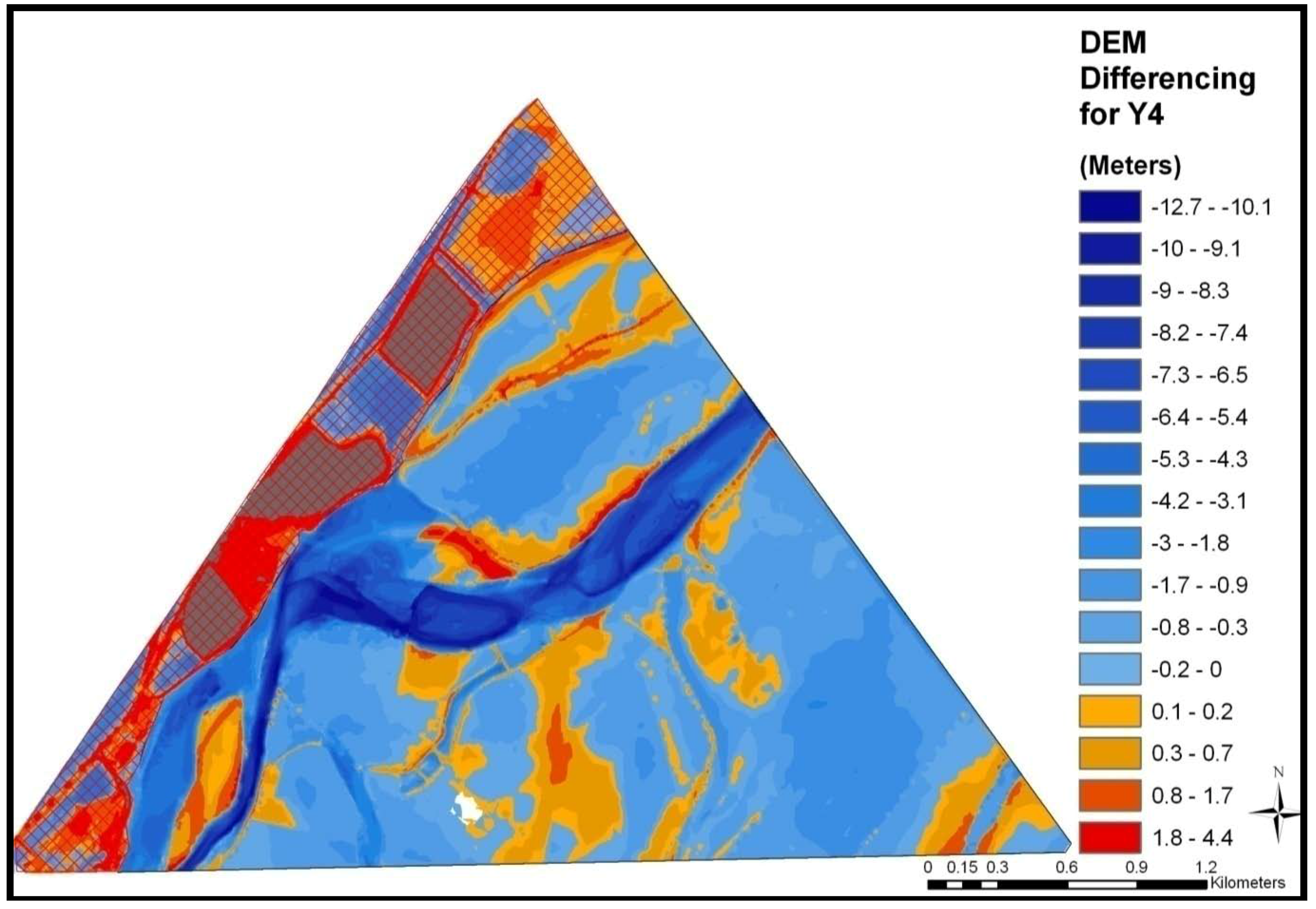
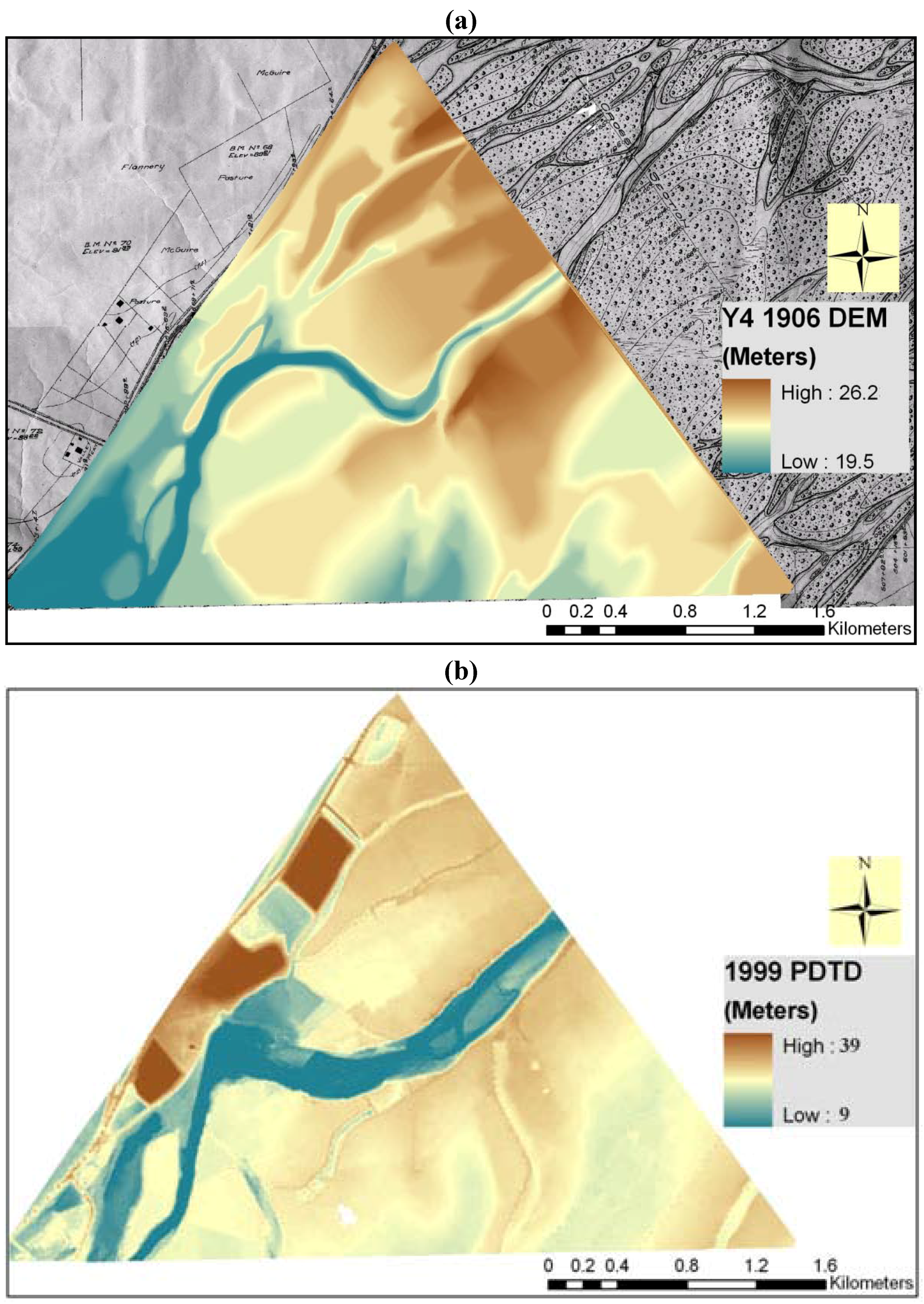
The CDC (1906) map at Y4 site shows similar landform features as the Y3 site. The floodplain is 3.9 km wide. In 1906 the deepest point in the channel at the Y4 site was at an elevation of 24.8 m above m.s.l., while in 1999 the deepest point was 12.1 m lower at 12.7 m above m.s.l. A portion of the north-western bank of the river was masked out and omitted from the Y4 site volumetric analysis owing to the presence of a landfill (
Figure 11). Similar to erosion at Y3, the maximum amount of erosion at site Y4 occurred in the channels followed by emergent bars, high-water channels and terraces (
Table 2). The areas of the 1999 channel all experienced substantial incision since 1906. A reach of channel along the north bank of the modern channel, in the center of the image, filled during this period. This deposition, classified here as ‘bar’ sedimentation, represents a relatively recent avulsion that is documented in the planimetric analysis. Channel bars received the maximum volume of deposition followed by terraces and high-water channels. Unlike at reach Y3, high-water channels received a considerable amount of deposition. In addition, a thin layer of sediment (0–0.6 m deep) was deposited widely across the floodplain (
Figure 11), presumably owing to vertical accretion by overbank flow. While natural levees clearly formed along the modern main channel and high-water channels, they are less massive or extensive than in the Y3 reach. This could represent a distal decline in overbank sediment supplies downstream from the Yuba Gold Fields, although more analysis is needed to test this possibility. The net change in sediment volumes at this site for the 93-year period was an erosion of 5.1 × 10
6 m
3 with a total erosion of 7.1 × 10
6 m
3 and total deposition of 1.9 × 10
6 m
3.
Table 2.
Volumetric changes from 1906 to 1999 at Y4.
Table 2.
Volumetric changes from 1906 to 1999 at Y4.
| | Erosion (m3) | Deposition (m3) | Net Change (m3) |
|---|
| Channels | −4,620,498 | 0 | −4,620,498 |
| Bars | −1,344,385 | 998,223 | −346,162 |
| High-water channels | −693,641 | 310,676 | −382,965 |
| Terraces | −409,834 | 674,689 | 264,854 |
| Total | −7,068,359 | 1,983,587 | −5,084,771 |
4.2. Planimetric Analysis
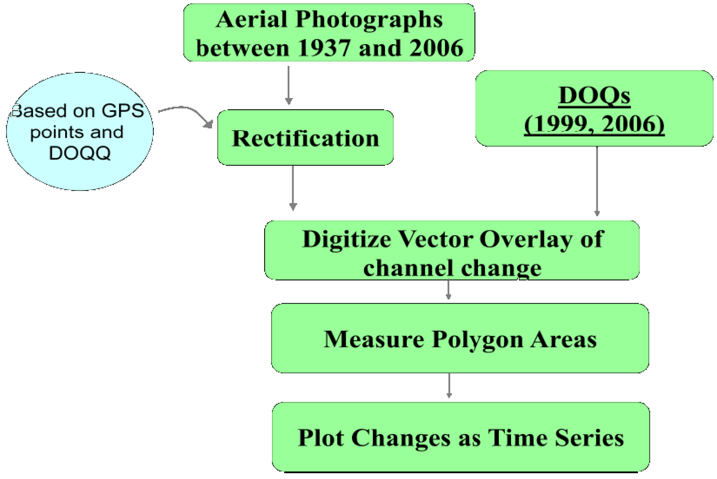
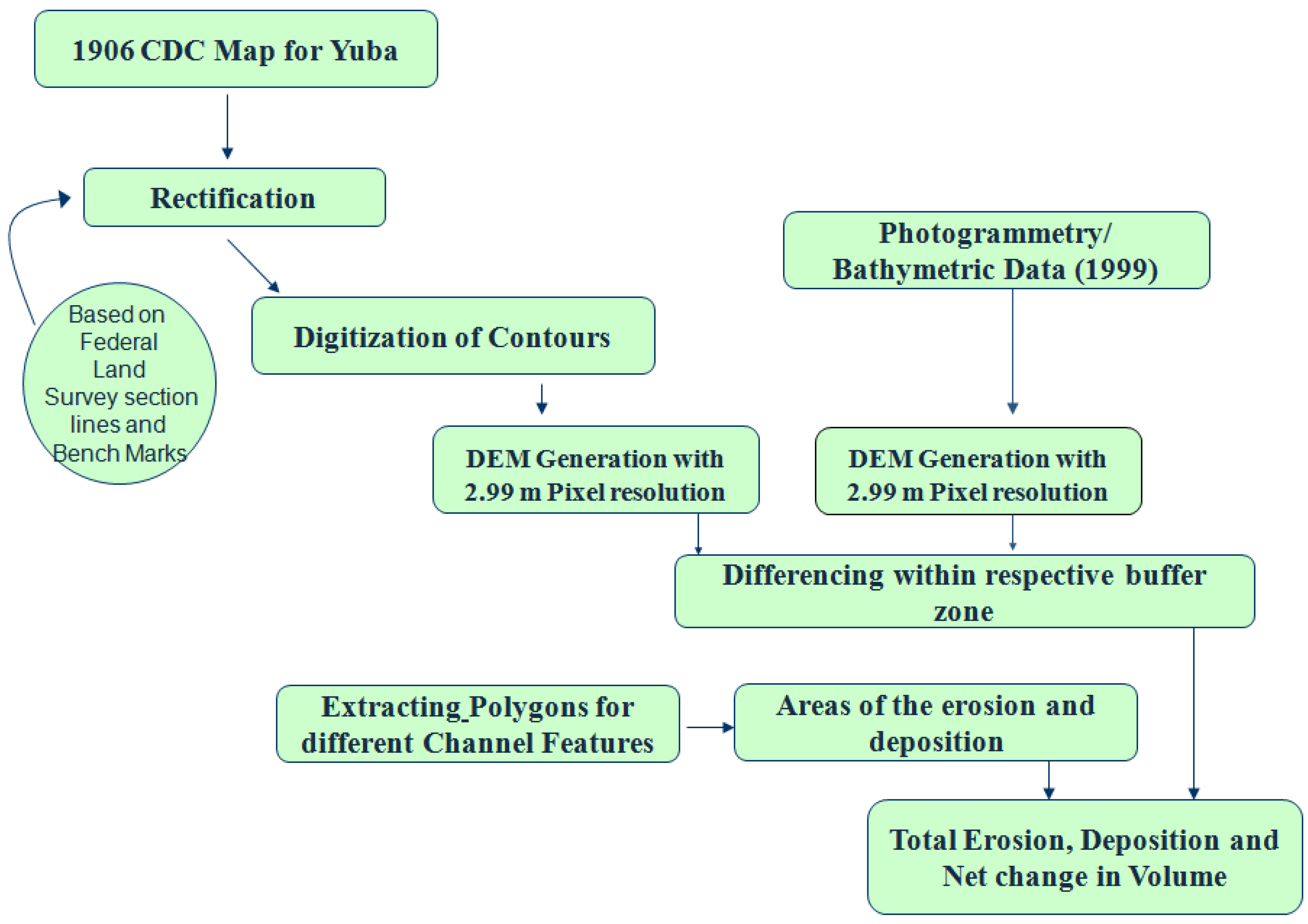
Spatial and temporal variations in channel enlargement, lateral migration, and associated surface areas of within-channel erosion and sedimentation were measured based on a remote sensing and GIS analysis of 1906
California Debris Commission (CDC) topographic maps [
26], aerial photographs flown between 1947 and 2006 (NAPP), DOQQs from 1999, 2006, and 1999 photogrammetric data (USACE [
24,
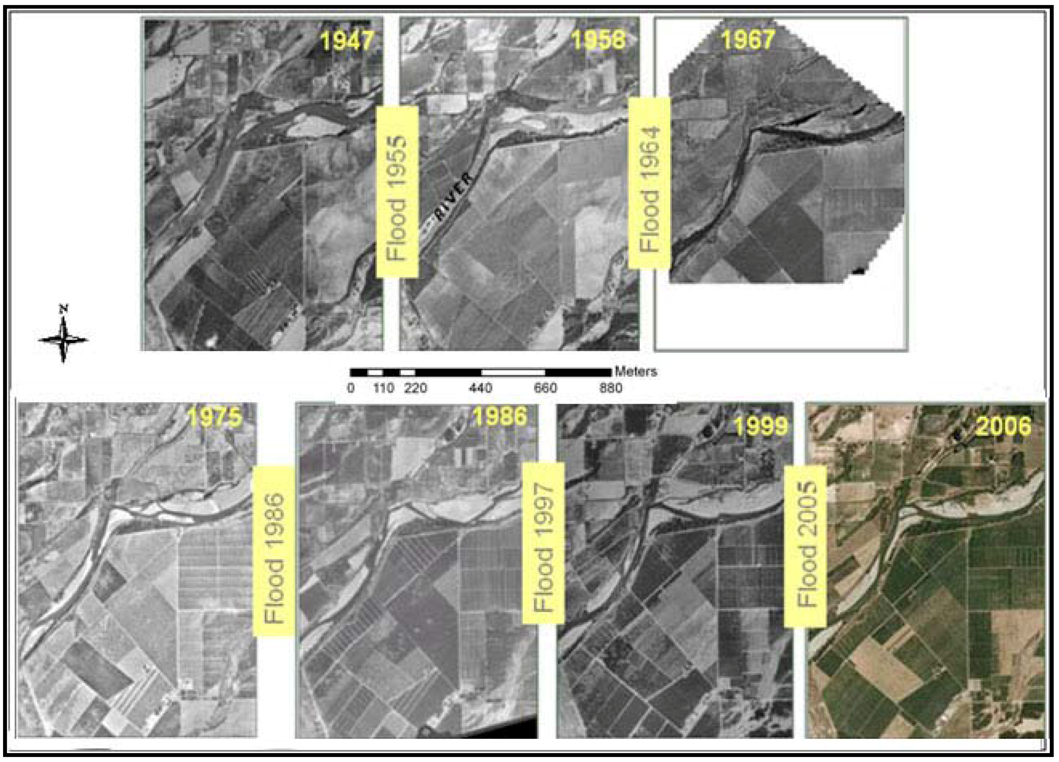
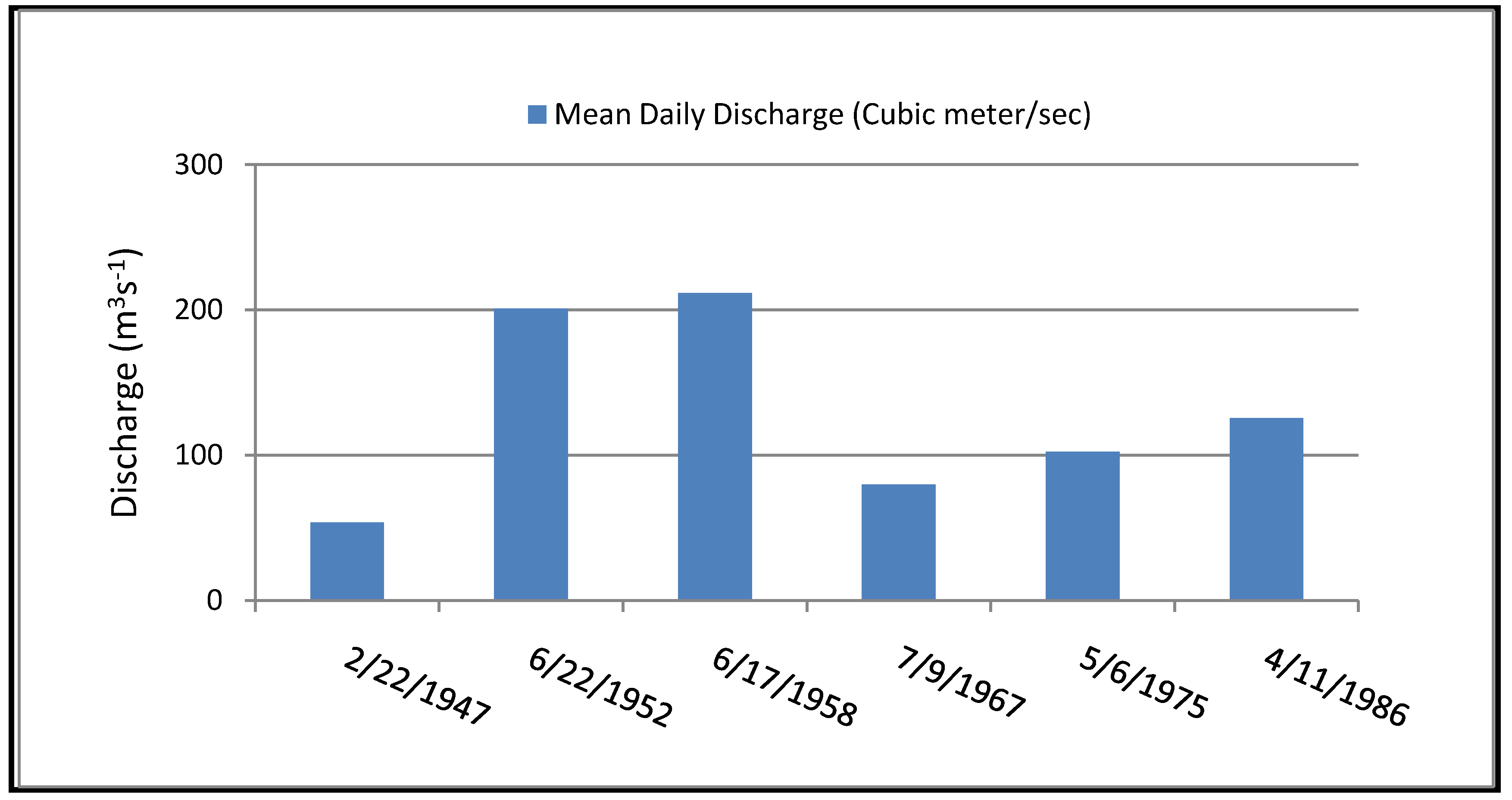
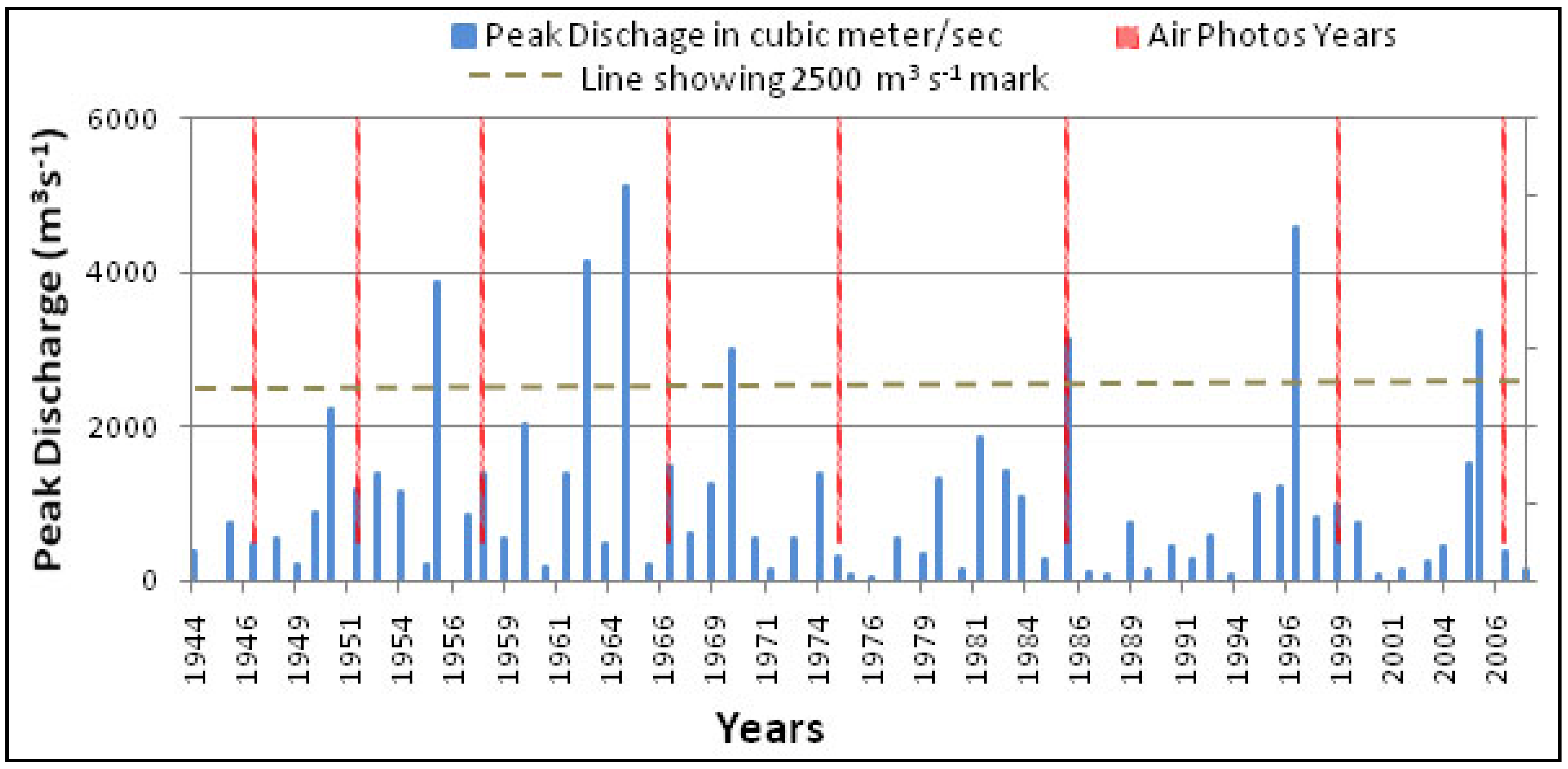
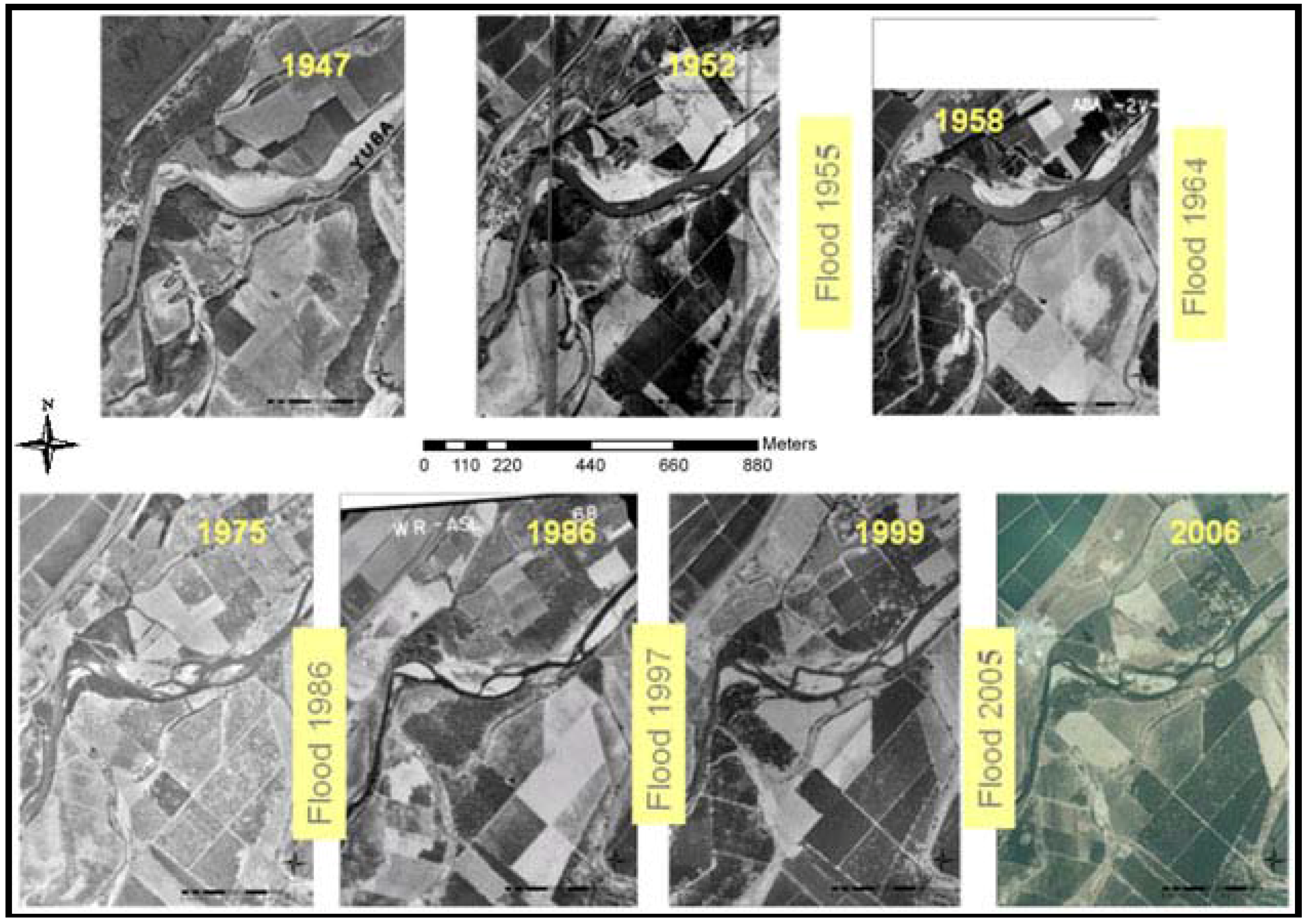
25]). These data were used to reconstruct historical channel changes and to calculate surface areas of erosion and sedimentation. Aerial photographs bracketing major flood years for Y3 (
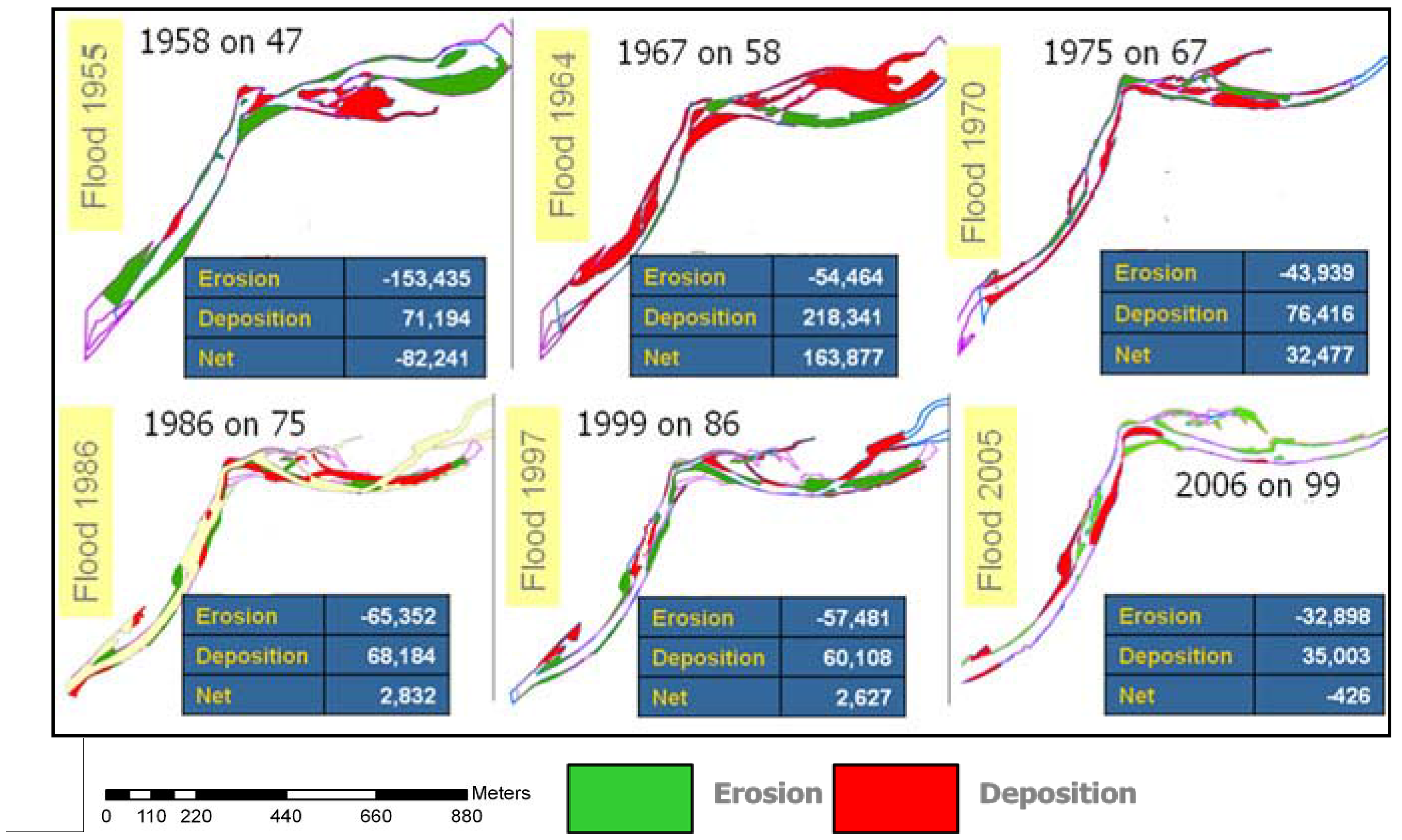
Figure 14) were used to measure changes in surface area corresponding to erosion and deposition by a given flood. For example, the overlay analysis between 1952 and 1958 aerial photographs reveals changes corresponding to erosion and deposition by the 1955 flood. The following sets of maps show total erosion and deposition at Y3 and Y4 for each period followed by bar charts of erosion and deposition for each period broken into bars and terraces. In this post-incision period, the replacement of water by new areas of land is always classified as ‘bars’ because deposition on high terraces cannot be detected by planimetric analysis which measures lateral migration.
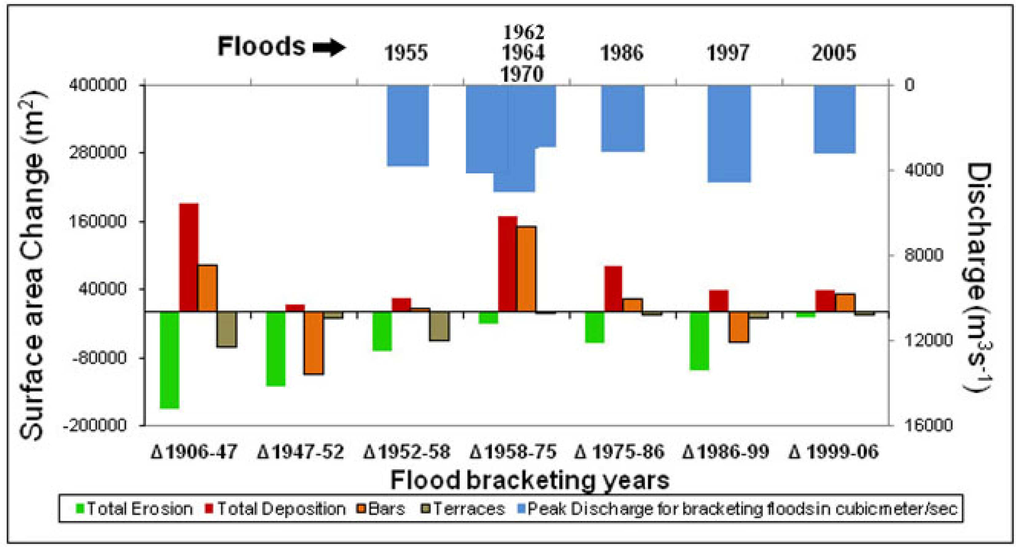
Changes in surface area at Y3 due to erosion and deposition by six different floods are shown in
Figure 17 and
Figure 18. The maps illustrate a greater amount of surface change in the first half of the century until 1960 with decreased lateral activity thereafter. In addition, the active zone of lateral channel activity apparently narrowed in the later period. The 1955 flood resulted in substantial net erosion of bars and terraces, whereas the 1964 flood deposited a considerable amount of sediment in channels to form new bars (
Figure 18). The net change for each period drops to a negligible value after 1986, but this does not indicate a lack of channel activity. Instead, it represents bar deposition in each period that is approximately equal to erosion.
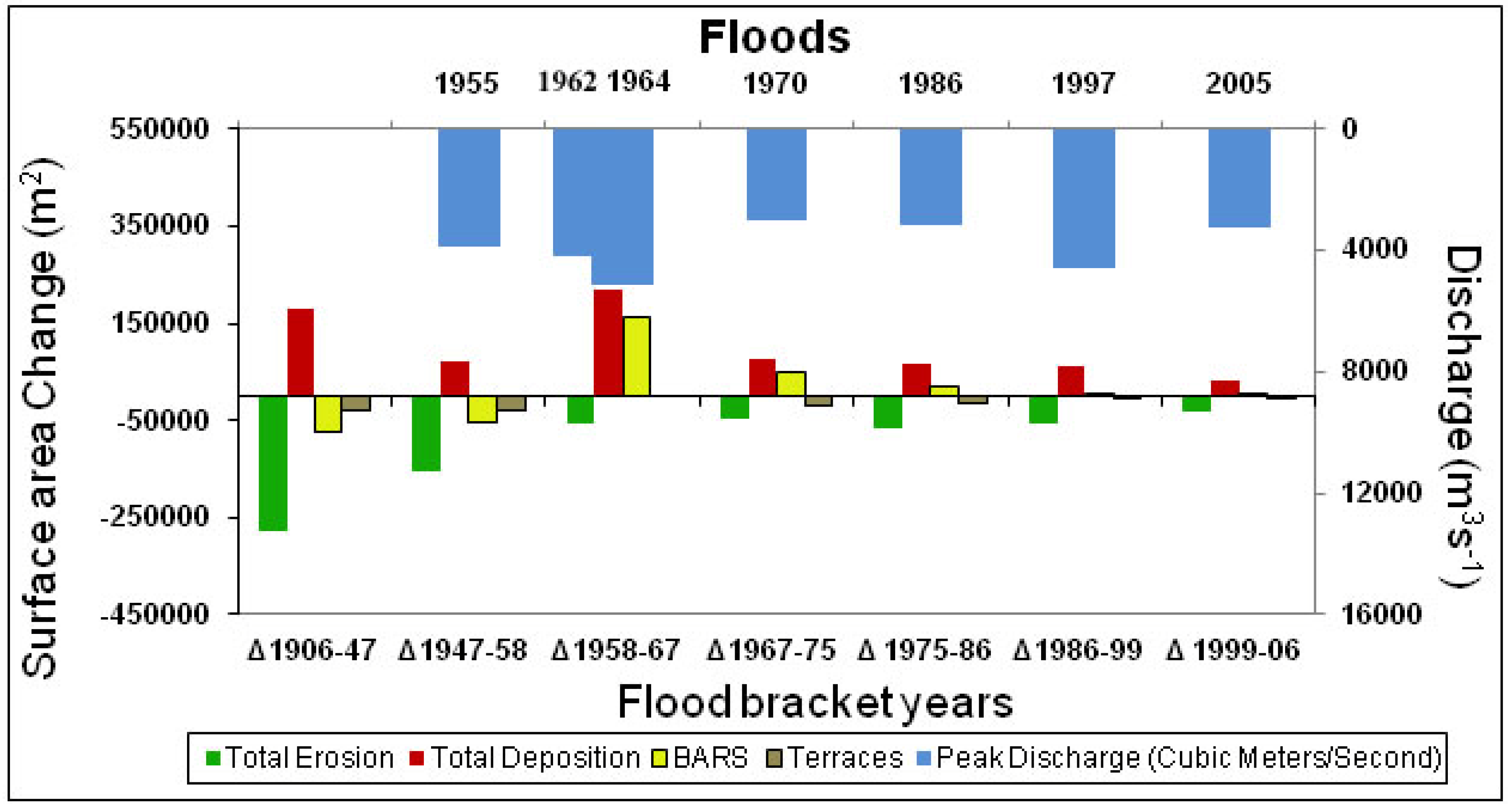
Areal changes separated into bars
versus terraces and into total erosion and total deposition (
Figure 19) reveal several features of channel change. Changes in bar and terrace surface areas on these bar charts represent net change (deposition − |erosion|), however, so values can be much smaller than total bar erosion or total terrace erosion. Both erosion and deposition were highly active in the early period as shown on the bar graph (
Figure 19). Creation of ~150 × 10
3 m
2 of new surface by the 1964 flood was entirely on lower surfaces classified here as emergent bars. Some of this deposition may be an artifact of the low discharge at the time that the 1967 aerial photograph was flown (
Figure 9), although that stage change was less than one meter. A moderately large flood in 1970 was presumably responsible for the deposition on bars that occurred between 1967 and 1975 over a surface extent of ~50 × 10
3 m
2. The 1986 and 1997 floods had high peak discharges, but a smaller surface area of bars or terraces was displaced by these floods.
In general, the areas of net erosion, net deposition, and total net change appear to have decreased somewhat after the 1964 flood and certainly after the 1986 flood (
Figure 17,
Figure 18,
Figure 19). Erosion and deposition continued throughout the study period. In fact, a major channel avulsion occurred on the south bank of the upper reach in response to the 1997 flood. A reduction in lateral activity did occur later in the study period, however, such that lateral migration and point bar formation became confined to a narrower band. This was independent of flood magnitudes which did not decrease during the period of study (
Figure 19).
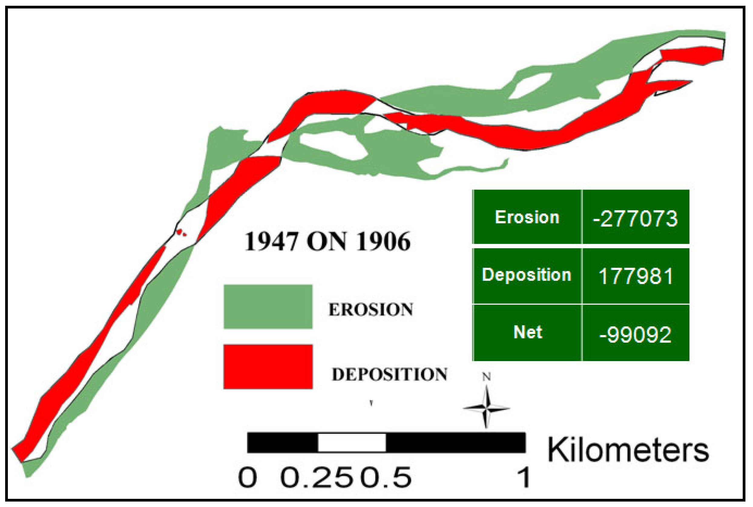
Figure 17.
Erosion and deposition polygons showing areas of sediment reworked at the Y3 site for the period between 1906 and 1947. Table shows changes in area due to erosion, deposition and net change. Areas are in square meters.
Figure 17.
Erosion and deposition polygons showing areas of sediment reworked at the Y3 site for the period between 1906 and 1947. Table shows changes in area due to erosion, deposition and net change. Areas are in square meters.
Figure 18.
Erosion and deposition polygons showing areas (m2) of sediment reworked by each flood at the Y3 site. Tables show changes in area due to erosion, deposition and net change for each flood year.
Figure 18.
Erosion and deposition polygons showing areas (m2) of sediment reworked by each flood at the Y3 site. Tables show changes in area due to erosion, deposition and net change for each flood year.
Figure 19.
Surface areas of total, bar and terrace, erosion and deposition corresponding to each flood period at the Y3 site. Positive area changes represent deposition; negative area changes are erosion. Values of total erosion and total deposition are for bars plus terraces, while values of bars and terraces represent net changes from erosion plus deposition.
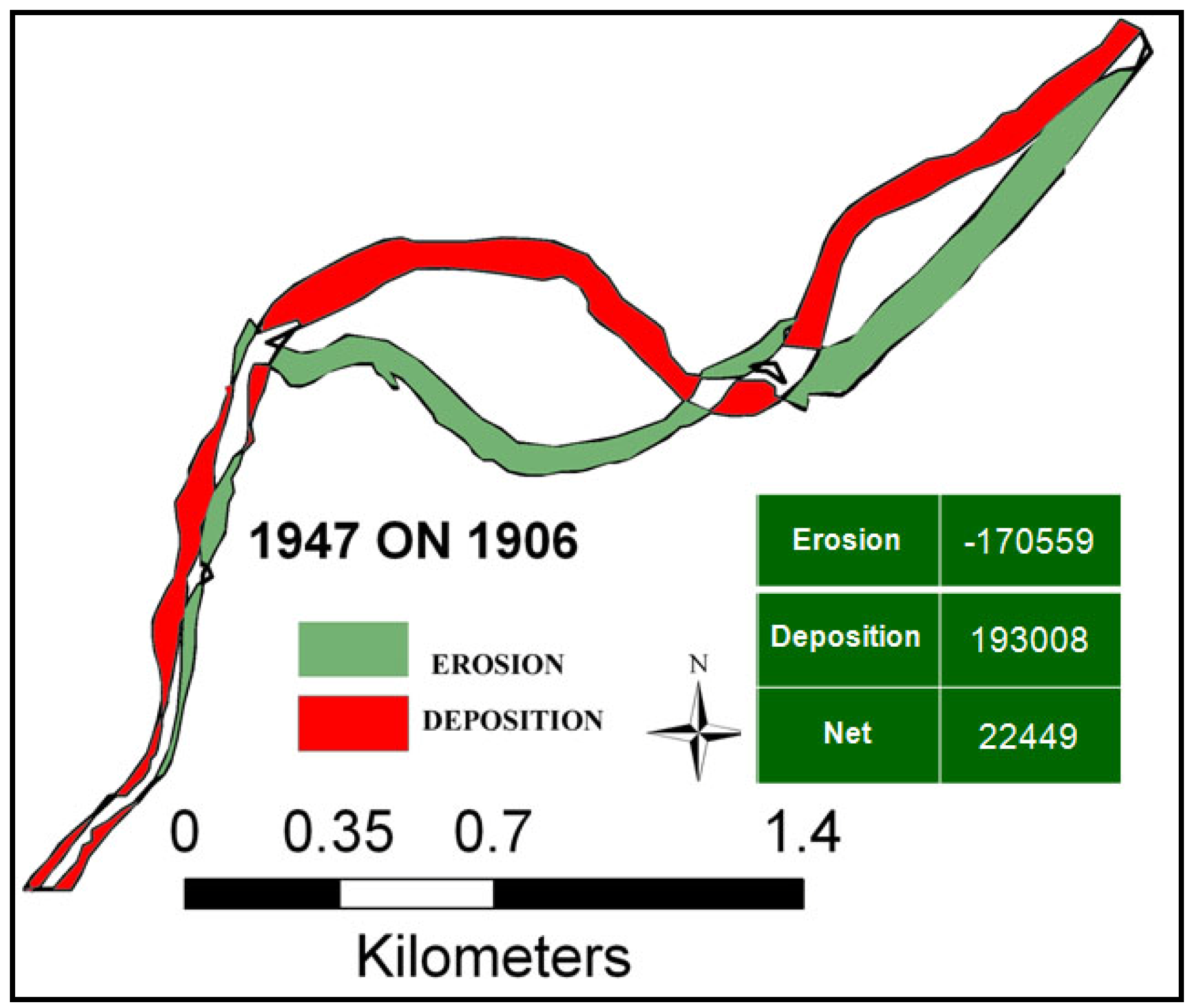
Similar planimetric results are obtained for the Y4 site, where major avulsions and expanses of lateral migration occurred in the early period 1906 to 1947 (
Figure 20). These avulsions were associated with large areas of erosion and deposition, 17 × 10
3 m
2 and 193 × 10
3 m
2, respectively, but only modest areas of net change. These areas of erosion and sedimentation are the largest for any single period, although comparability is limited by the longer duration of time.
Figure 20.
Erosion and deposition polygons showing areas (m2) of sediment reworked at Y4 site for the period between 1906 and 1947. The table shows the change in area due to erosion, deposition and net change.
Figure 20.
Erosion and deposition polygons showing areas (m2) of sediment reworked at Y4 site for the period between 1906 and 1947. The table shows the change in area due to erosion, deposition and net change.
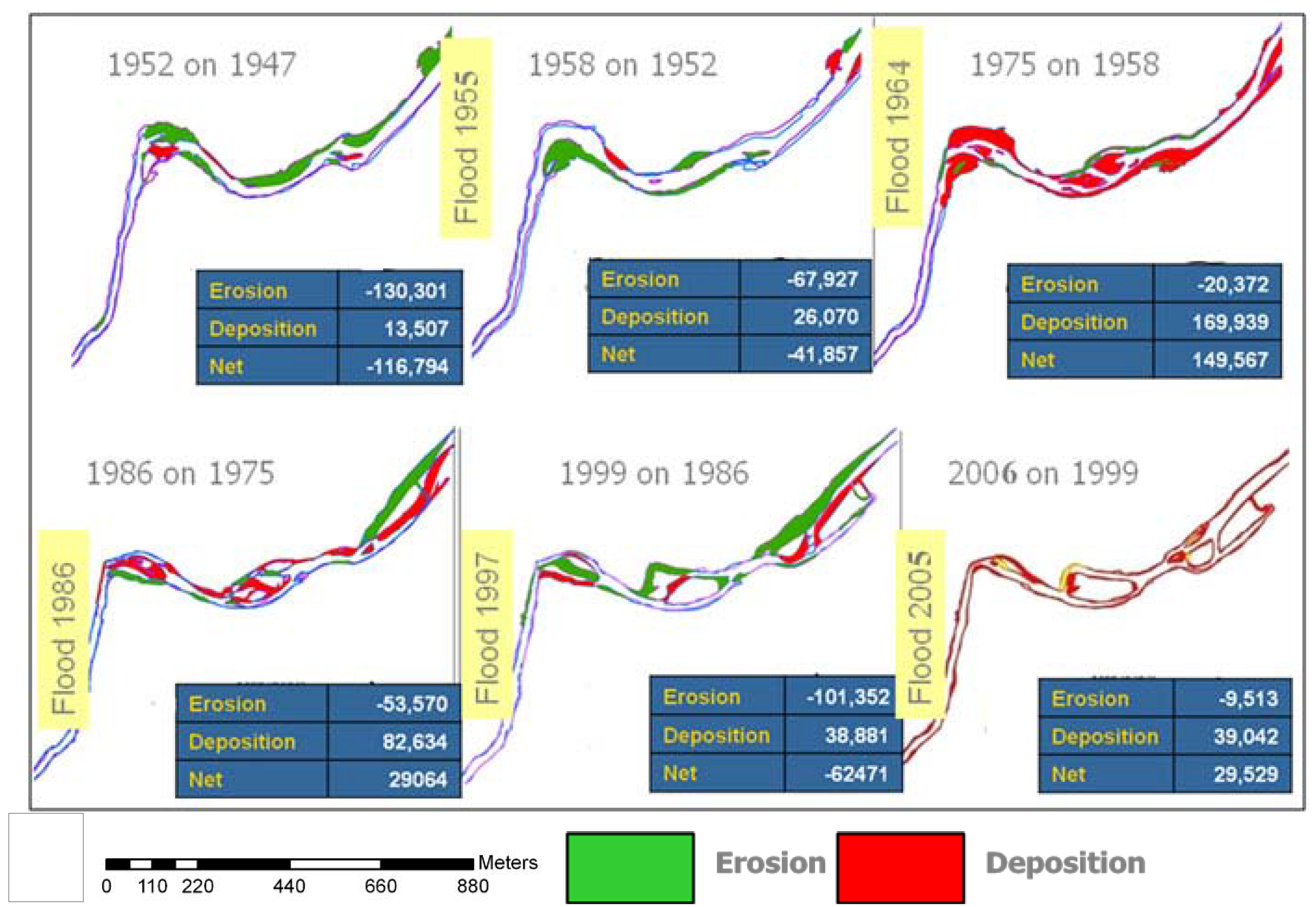
Subsequently, the 1955 flood eroded ~42 × 10
3 m
2 of terrace surfaces and the 1964 flood deposited sediment creating ~150 × 10
3 m
2 of new bar surfaces (
Figure 21 and
Figure 22). As at the Y3 site, the 1986 and the 1997 floods displaced smaller areas compared to the earlier floods at the Y4 site, although the magnitude of the later floods are no less than the earlier floods. The 1997 flood (Q = 2,793 m
3s
−1; 161,000 ft
3s
−1) had a higher peak discharge than the 1955 flood (Q = 2,515 m
3s
−1; 136,000 ft
3s
−1) (U.S. Geological Survey gauge data).
Two large deposition events are documented by the planimetric data from the 1950s through the 1970s. The Y3 site experienced ~200,000 m
2 of bar deposition in 1964 and the Y4 site experienced almost as much deposition in the 1970s. The Y3 deposition event is explained by a substantial channel avulsion in the northern section of the reach that caused abandonment of a large area of the north channel. This increased area of emergent bars was not compensated for by lateral migration of the channel into the south bank indicating that the channel narrowed in the upper reaches of Y3. Deposition at the Y4 site between 1958 and 1975 may best be explained by three factors. First, this was a longer period than most, extending 17 years. Second, two moderately large floods occurred during this period, which apparently caused the channel to narrow and abandon emergent bars. Finally, the 1958 aerial photograph that forms the basis of the depositional area calculation, was a high flow (
Figure 9 and
Figure 15) that tends to overestimate new exposed bar areas on subsequent images.
A substantial period of erosion occurred from 1975 to 1999 at Y4 in response to lateral migration through the entire period. Migration is shown by the gradual southward movement of the northern eroded channel in the period 1975–1986 that included the 1986 flood and in the period 1986–1999 that included the 1997 flood (
Figure 21). Apparently, these changes represent progressive migration across the north bar rather than an avulsion from one location to another. Therefore, it represents the displacement of a large volume of sediment as the thalweg moved across the entire area.
Figure 21.
Erosion and deposition polygons showing areas of sediment reworked by floods at the Y4 site. Tables show changes in area (m2) due to erosion, deposition and net change for each flood.
Figure 21.
Erosion and deposition polygons showing areas of sediment reworked by floods at the Y4 site. Tables show changes in area (m2) due to erosion, deposition and net change for each flood.
Figure 22.
Surface areas of total, bar and terrace, erosion and deposition corresponding to each flood at the Y4 site. Positive area changes represent deposition; negative changes are erosion. Values of total erosion and total deposition are for bars plus terraces, while values of bars and terraces represent net changes from erosion plus deposition.
4.2.1. Implications of Planimetric Analysis
The planimetric change analysis between 1906 and 1947 shows the highest change in area for both the sites (
Figure 19 and
Figure 22). Apparently, bar and terrace erosion as measured by planimetric changes was somewhat more active during the early period, from 1906 through the 1970s than the later period from the 1980s onward. The total change in areas due to each flood tends to decrease towards the end of the century (
Figure 23) in spite of large floods occurring in the later period. Thus, on the basis of this planimetric analysis, it is not possible to reject the null hypothesis that morphologic changes were not greater during the early 20th century than subsequent changes later. In fact, the original hypothesis appears to be supported by the planimetric analysis;
i.e., floods after the 1970s were less effective than in the earlier period. Overall, total areas of planimetric change were fairly similar between sites Y3 and Y4 with the exception of deposition events in the 1960s at Y3 and in the 1970s at Y4 (
Figure 19 and
Figure 22). Both of those events represent episodic bar formation events that were part of long-term channel morphologic adjustments to decreased sediment loads and channel incision. It is not clear if the downstream shift in the avulsions from Y3 to Y4 through time represents a large-scale systematic trend. Similar to the temporal patterns demonstrated at Y3, areas of net erosion, net deposition, and total net change decreased somewhat in the later period after the 1970 flood (
Figure 22). Three floods occurred in the period 1958 to 1975, which limits the ability to resolve which floods within this period were geomorphically effective. It is possible that the timing of the decline in activity is similar between the two sites (compared with
Figure 19). This decline was independent of flood magnitudes.
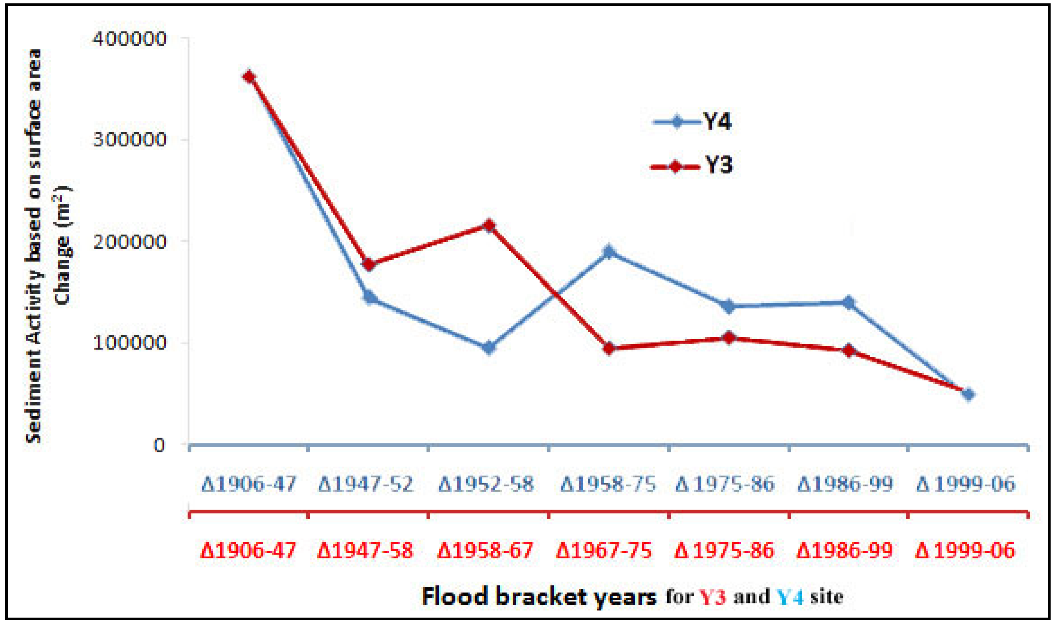
Figure 23.
Total amount of sediment displaced (|erosion| + |deposition|) decreased during the later half of the 20th century at both the Y3 and Y4 sites. The X axes are not to scale.
Figure 23.
Total amount of sediment displaced (|erosion| + |deposition|) decreased during the later half of the 20th century at both the Y3 and Y4 sites. The X axes are not to scale.


