Assessing Plant Diversity in a Dry Tropical Forest: Comparing the Utility of Landsat and Ikonos Satellite Images

Abstract
:1. Introduction
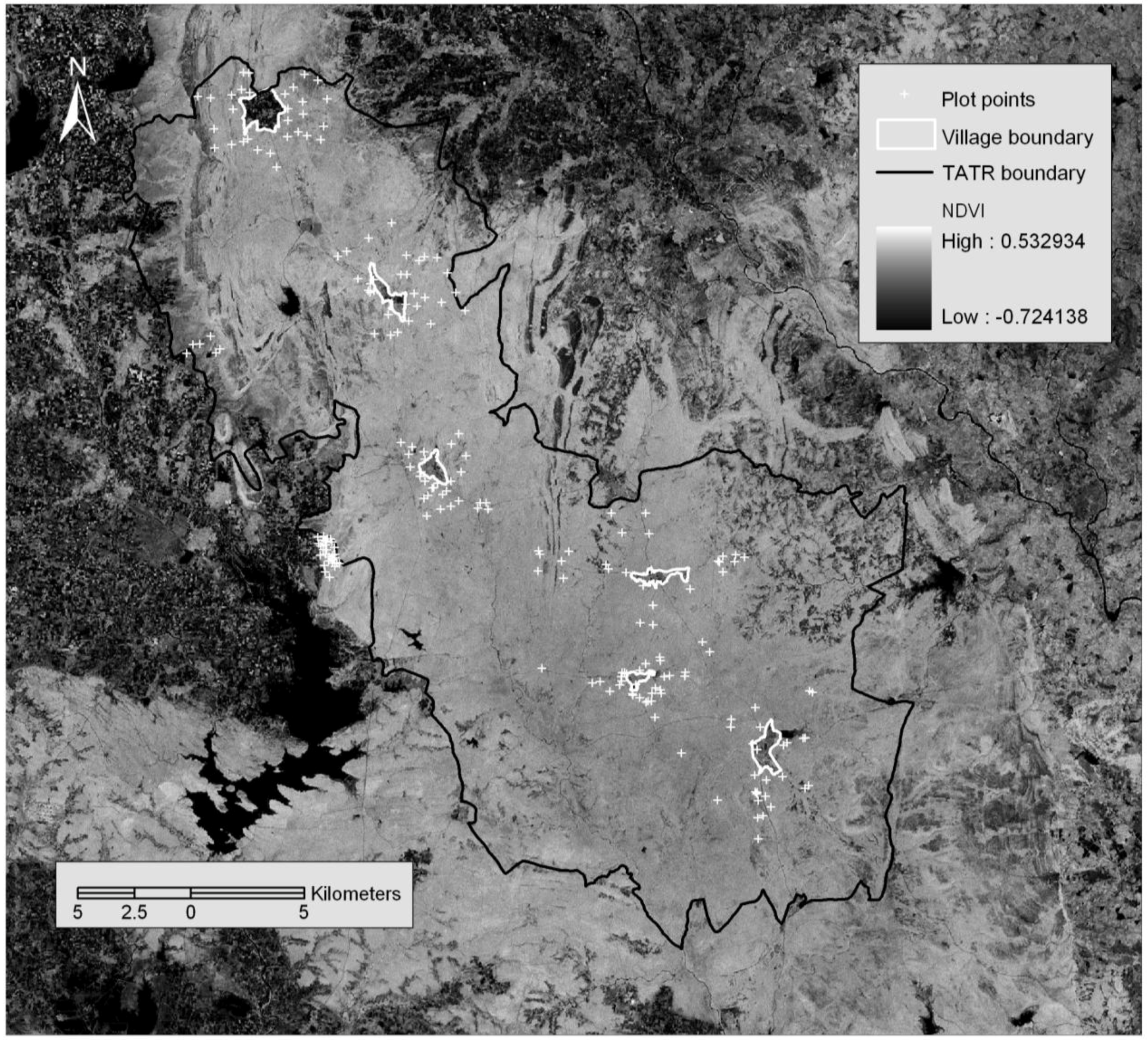
2. Study Area
3. Materials and Methods
3.1. Data Gathering
3.1.1. Field data collection
3.1.2. Image data acquisition and pre-processing
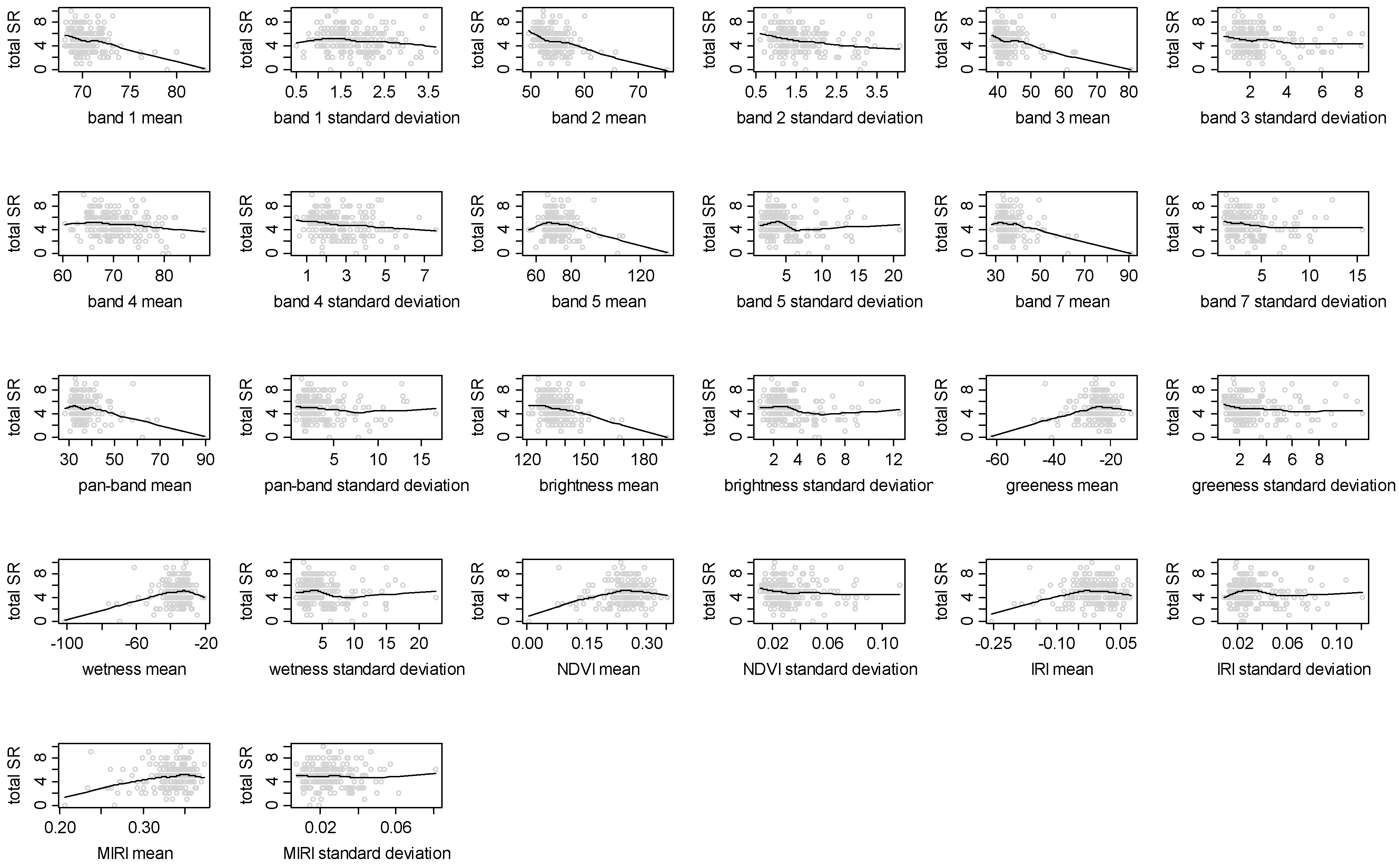
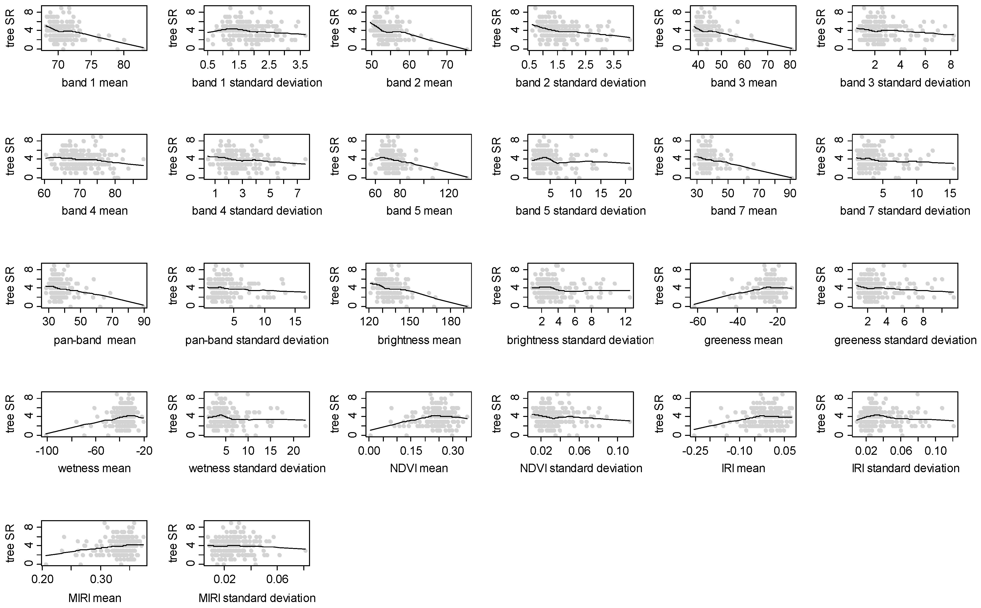
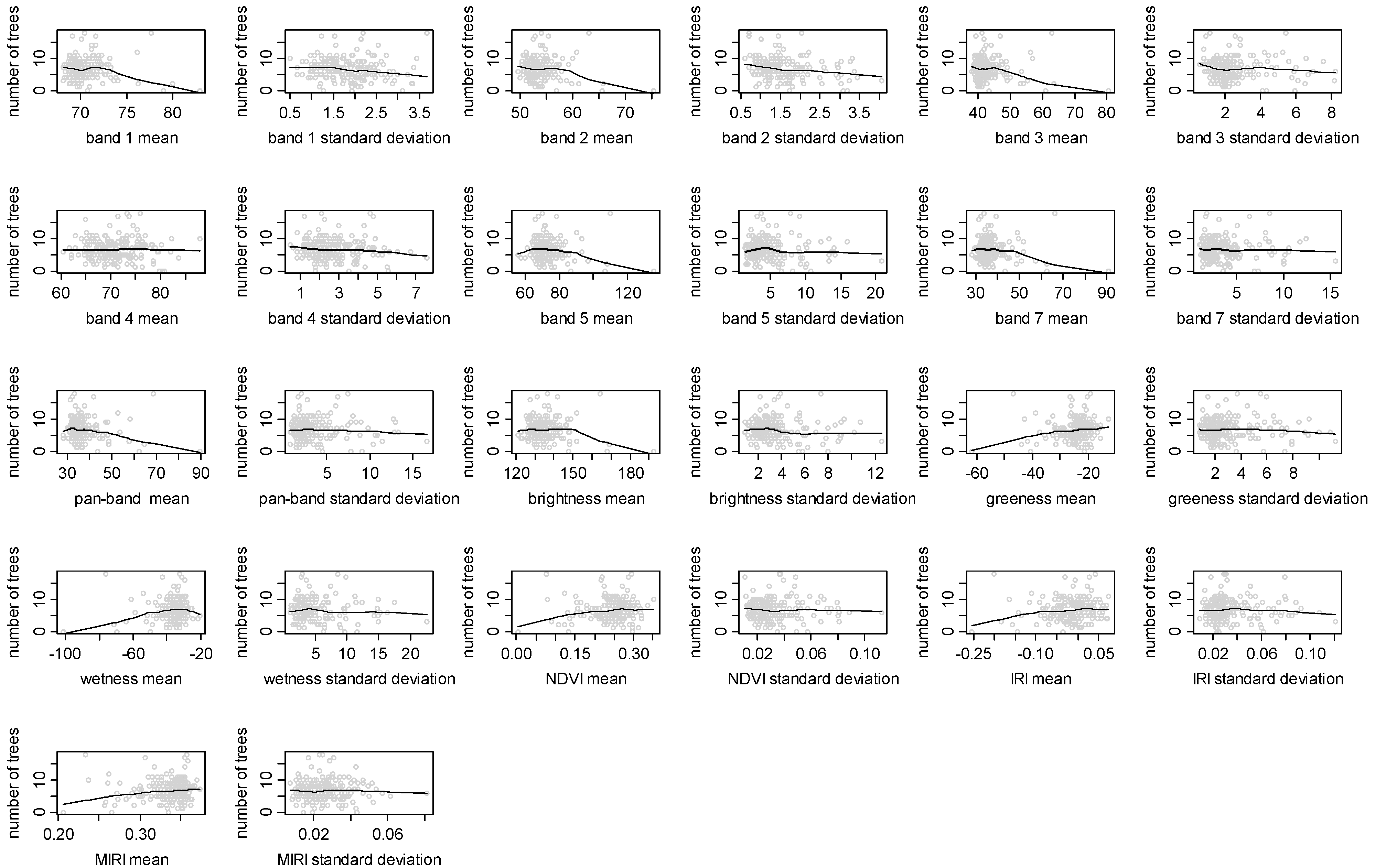
3.2. Data Analysis: Relationship Between Spectral and Plant Biodiversity Data
4. Results

| Spectral variable | Total species richness | Tree species richness | Tree Shannon diversity | Number of trees |
|---|---|---|---|---|
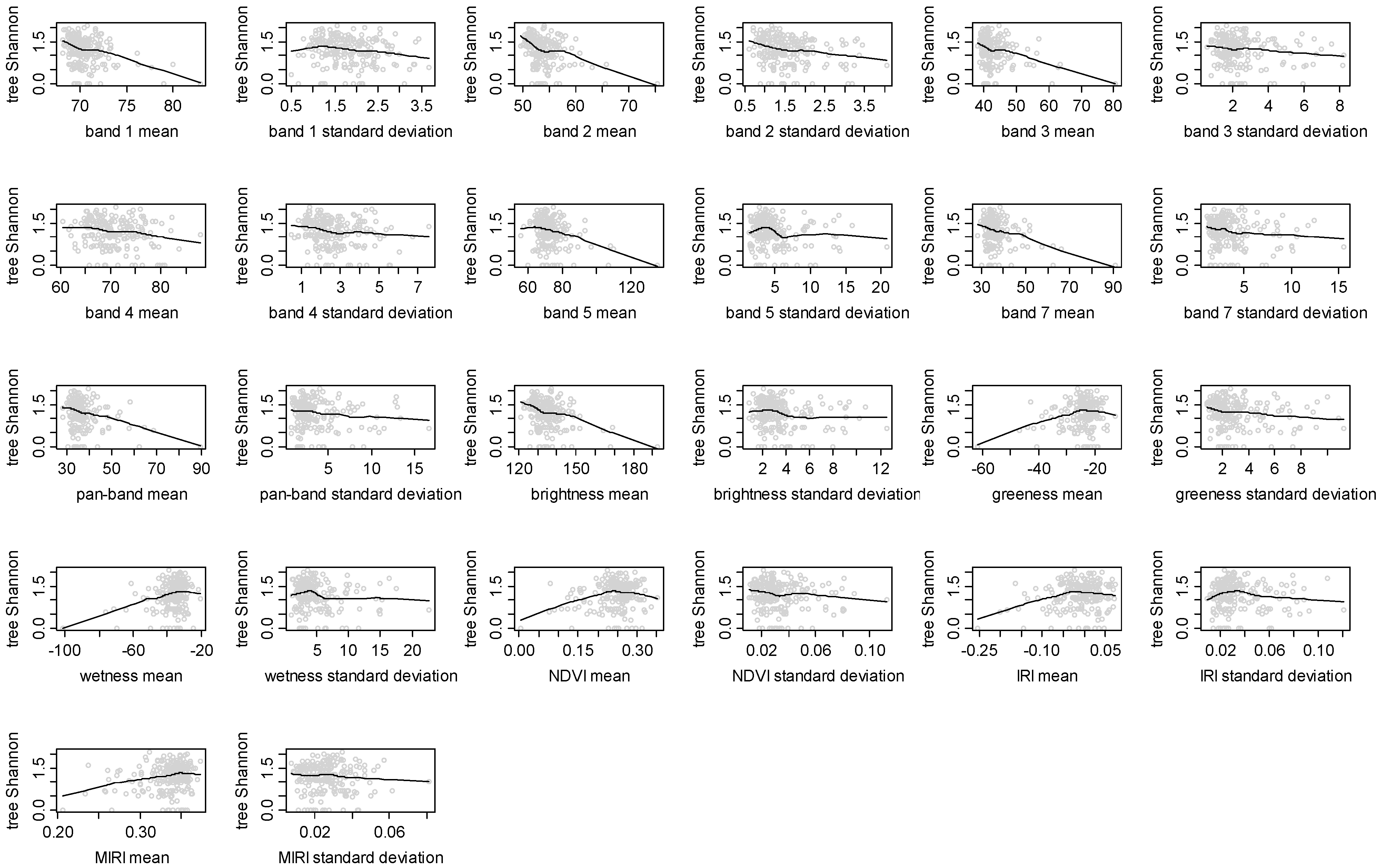
| Band 1 Mean | −0.328*** | −0.275*** | −0.297*** | −0.066 |
| Band 1 Standard Deviation | −0.118 | −0.152* | −0.125 | −0.112 |
| Band 2 Mean | −0.336*** | −0.316*** | −0.336*** | −0.105 |
| Band 2 Standard Deviation | −0.263*** | −0.281*** | −0.225*** | −0.242*** |
| Band 3 Mean | −0.293*** | −0.251*** | −0.26*** | −0.091 |
| Band 3 Standard Deviation | −0.139* | −0.131 | −0.129 | −0.045 |
| Band 4 Mean | −0.172* | −0.142* | −0.186** | 0.019 |
| Band 4 Standard Deviation | −0.146* | −0.135 | −0.167* | −0.075 |
| Band 5 Mean | −0.246*** | −0.255*** | −0.268*** | −0.115 |
| Band 5 Standard Deviation | −0.137* | −0.142* | −0.151* | −0.068 |
| Band 7 Mean | −0.254*** | −0.25*** | −0.26*** | −0.112 |
| Band 7 Standard Deviation | −0.093 | −0.105 | −0.117 | −0.039 |
| Panchromatic Band Mean | −0.276*** | −0.263*** | −0.269*** | −0.133 |
| Panchromatic Band Standard Deviation | −0.125 | −0.115 | −0.138* | −0.013 |
| Brightness Mean | −0.305*** | −0.278*** | −0.307*** | −0.077 |
| Brightness Standard Deviation | −0.181** | −0.179** | −0.179** | −0.108 |
| Greenness Mean | 0.202** | 0.192** | 0.18** | 0.112 |
| Greenness Standard Deviation | −0.101 | −0.107 | −0.123 | −0.007 |
| Wetness Mean | 0.228*** | 0.241*** | 0.25*** | 0.118 |
| Wetness Standard Deviation | −0.12 | −0.131 | −0.142* | −0.061 |
| NDVI Mean | 0.166* | 0.144* | 0.125 | 0.087 |
| NDVI Standard Deviation | −0.089 | −0.098 | −0.105 | −0.021 |
| IRI Mean | 0.119 | 0.154* | 0.138* | 0.117 |
| IRI Standard Deviation | −0.041 | −0.041 | −0.063 | 0.004 |
| MIRI Mean | 0.22** | 0.193** | 0.193** | 0.092 |
| MIRI Standard Deviation | 0.01 | −0.004 | −0.036 | 0.001 |


| Spectral variable | Total species richness | Tree species richness | Tree Shannon diversity | Number of trees |
|---|---|---|---|---|
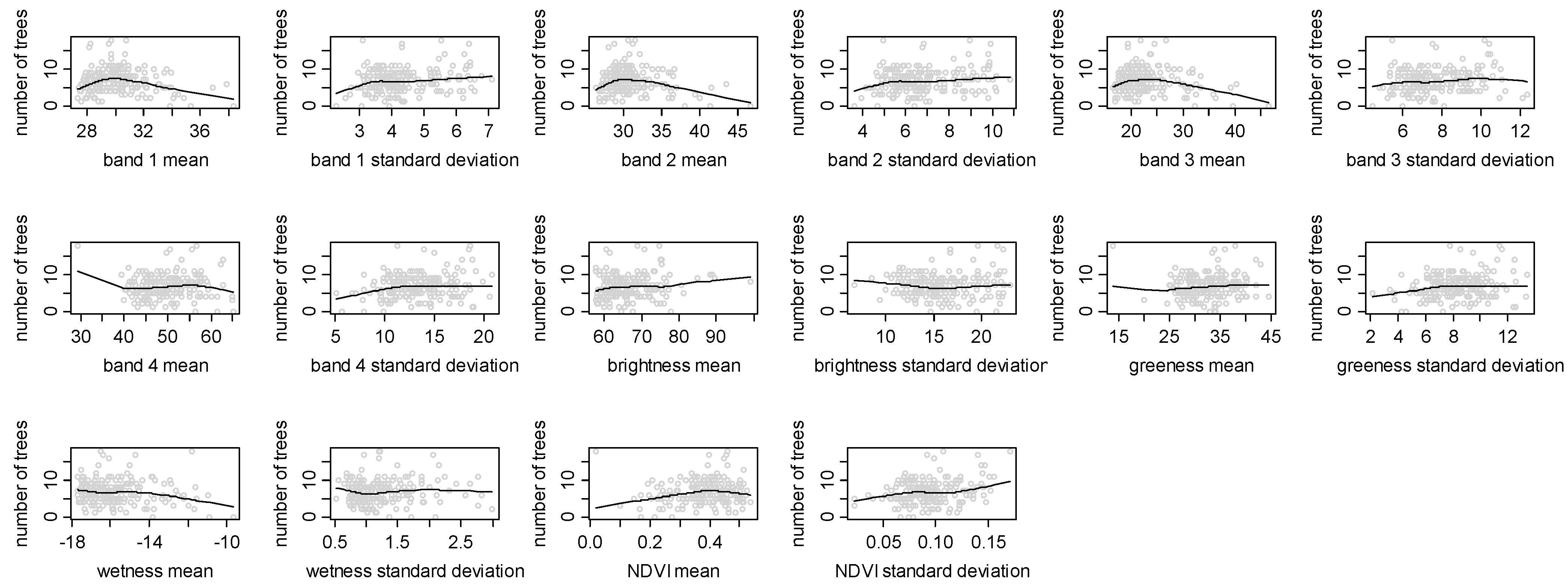
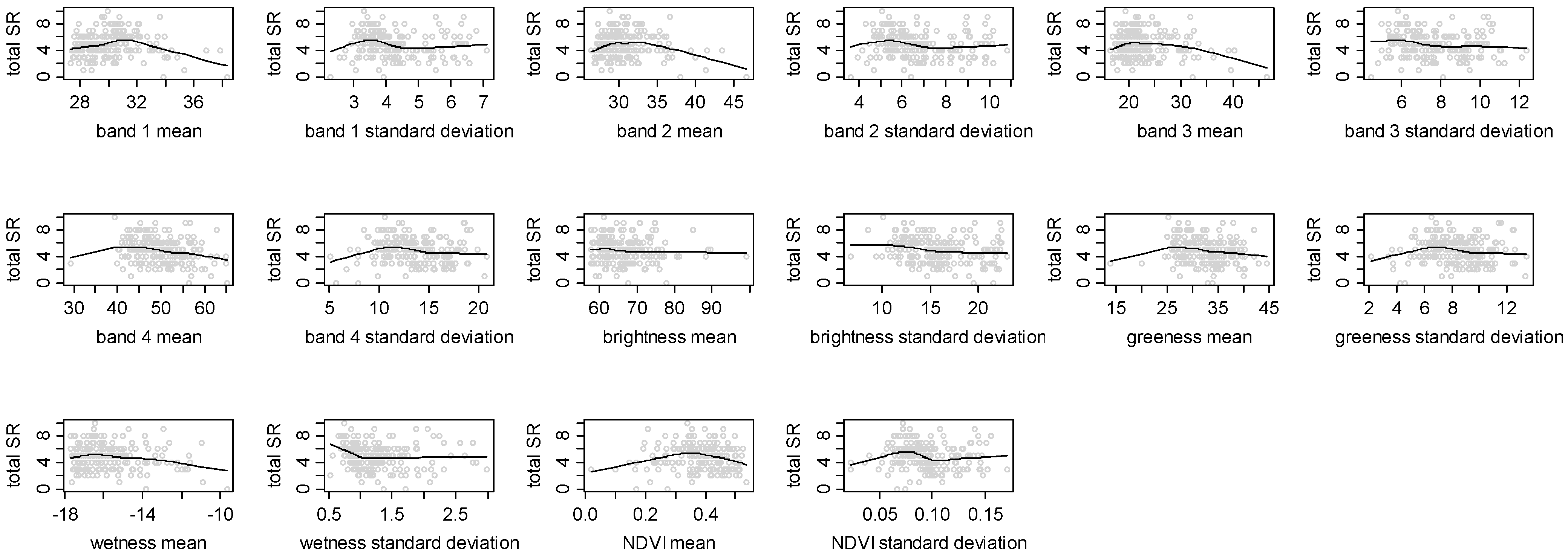
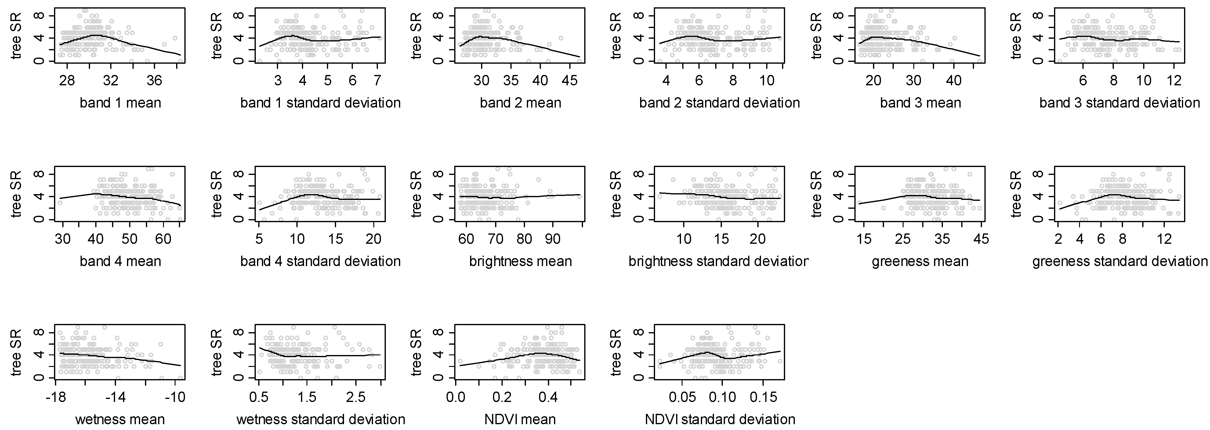
| Band 1 Mean | −0.018 | −0.041 | −0.012 | −0.131 |
| Band 1 Standard Deviation | −0.118 | −0.007 | −0.050 | 0.198*** |
| Band 2 Mean | −0.133 | −0.148* | −0.129 | −0.159* |
| Band 2 Standard Deviation | −0.127 | −0.021 | −0.066 | 0.183*** |
| Band 3 Mean | −0.149* | −0.159* | −0.142* | −0.138* |
| Band 3 Standard Deviation | −0.140* | −0.044 | −0.090 | 0.158* |
| Band 4 Mean | −0.235*** | −0.149* | −0.181** | 0.016 |
| Band 4 Standard Deviation | −0.080 | 0.012 | −0.056 | 0.175* |
| Brightness Mean | −0.080 | −0.008 | −0.050 | 0.131 |
| Brightness Standard Deviation | −0.187** | −0.127 | −0.175** | 0.051 |
| Greenness Mean | −0.164* | −0.069 | −0.110 | 0.086 |
| Greenness Standard Deviation | −0.068 | 0.026 | −0.049 | 0.166* |
| Wetness Mean | −0.169* | −0.192** | −0.176** | −0.119 |
| Wetness Standard Deviation | −0.114 | −0.056 | −0.098 | 0.057 |
| NDVI Mean | −0.020 | 0.042 | 0.012 | 0.099 |
| NDVI Standard Deviation | −0.106 | 0.011 | −0.054 | 0.235*** |


5. Discussion
Acknowledgements
References
- Kerr, J.T.; Ostrovsky, M. From space to species: ecological applications for remote sensing. Trends Ecol. Evol. 2003, 18, 299–305. [Google Scholar] [CrossRef]
- Carter, G.A.; Lucas, K.L.; Blossom, G.A.; Lassitter, C.L.; Holiday, D.M.; Mooneyhan, D.S.; Fastring, D.R.; Holcombe, T.R.; Griffith, J.A. Remote sensing and mapping of tamarisk along the Colorado river, USA: a comparative use of summer-acquired Hyperion, Thematic Mapper and QuickBird data. Remote Sens. 2009, 1, 318–329. [Google Scholar] [CrossRef]
- Prasad, P.R.C.; Nagabhatla, N.; Reddy, C.S.; Gupta, S.; Rajan, K.S.; Raza, S.H.; Dutt, C.B.S. Assessing forest canopy closure in a geospatial medium to address management concerns for tropical islands—Southeast Asia. Environ. Monit. Assess. 2009. [Google Scholar] [CrossRef] [PubMed]
- Wang, L.; Sousa, W.P.; Gong, P.; Biging, G. Comparison of IKONOS and QuickBird images for mapping mangrove species on the Caribbean coast of Panama. Remote Sens. Environ. 2004, 91, 432–440. [Google Scholar] [CrossRef]
- Everitt, J.J.; Fletcher, R.S.; Elder, H.S.; Yang, C. Mapping giant salvinia with satellite imagery and image analysis. Environ. Monit. Assess. 2008, 139, 35–40. [Google Scholar] [CrossRef] [PubMed]
- Duro, D.C.; Coops, N.C.; Wulder, M.A.; Han, T. Development of a large area biodiversity monitoring system driven by remote sensing. Prog. Phys. Geogr. 2007, 31, 253–260. [Google Scholar] [CrossRef]
- Nagendra, H.; Rocchini, D. Satellite imagery applied to biodiversity study in the tropics: the devil is in the detail. Biodiv. Conserv. 2008, 17, 3431–3442. [Google Scholar] [CrossRef]
- Nagendra, H.; Gadgil, M. Satellite imagery as a tool for monitoring species diversity: an assessment. J. Appl. Ecol. 1999, 36, 388–397. [Google Scholar] [CrossRef]
- Sanchez-Azofeifa, G.A.; Castro, K.L.; Rivard, B.; Kalascka, M.R.; Harriss, R.C. Remote sensing research priorities in tropical dry forest environments. Biotropica 2003, 35, 134–142. [Google Scholar] [CrossRef]
- Loarie, S.R.; Joppa, L.N.; Pimm, S.L. Satellites miss environmental priorities. Trends Ecol. Evol. 2007, 22, 630–632. [Google Scholar] [CrossRef] [PubMed]
- Nagendra, H. Using remote sensing to assess biodiversity. Int. J. Remote Sens. 2001, 22, 2377–2400. [Google Scholar] [CrossRef]
- Turner, B.L., II; Lambin, E.F.; Reenberg, A. The emergence of land change science for global environmental change and sustainability. Proc. Natl. Acad. Sci. USA 2008, 104, 20666–20671. [Google Scholar] [CrossRef] [PubMed]
- Read, J.M.; Clark, D.B.; Venticinque, E.M.; Moreiras, M.P. Application of merged 1-m and 4-m resolution satellite data to research and management in tropical forests. J. Appl. Ecol. 2003, 40, 592–600. [Google Scholar] [CrossRef]
- Kovacs, J.M.; King, J.M.L.; de Santiago, F.F.; Flores-Verdugo, F. Evaluating the condition of a mangrove forest of the Mexican Pacific based on an estimated leaf area index mapping approach. Environ. Monit. Assess. 2008. [Google Scholar] [CrossRef] [PubMed]
- Everitt, J.J.; Yang, C.; Johnson, H.B. Canopy spectra and remote sensing of Ashe juniper and associated vegetation. Environ. Monit. Assess. 2007, 130, 403–413. [Google Scholar] [CrossRef] [PubMed]
- Levin, N.; Shmida, A.; Levanoni, O.; Tamari, H.; Kark, S. Predicting mountain plant richness and rarity from space using satellite-derived vegetation indices. Divers. Distrib. 2007, 13, 692–703. [Google Scholar] [CrossRef]
- Rocchini, D. Effects of spatial and spectral resolution in estimating ecosystem α-diversity by satellite imagery. Remote Sens. Environ. 2007, 111, 423–434. [Google Scholar] [CrossRef]
- Warren, A.J.; Collins, M.J. A pixel-based semiempirical system for predicting vegetation diversity in boreal forest. Int. J. Remote Sens. 2007, 28, 83–105. [Google Scholar] [CrossRef]
- Curran, P.J. Remote sensing of foliar chemistry. Remote Sens. Environ. 1989, 30, 271–278. [Google Scholar] [CrossRef]
- Martin, M.E.; Aber, J.D. High spectral resolution remote sensing of forest canopy lignin, nitrogen, and ecosystem processes. Ecol. Appl. 1997, 7, 431–443. [Google Scholar] [CrossRef]
- Cochrane, M.A. Using vegetation reflectance variability for species level classification of hyperspectral data. Int. J. Remote Sens. 2000, 21, 2075–2087. [Google Scholar] [CrossRef]
- Clark, M.; Roberts, D.A.; Clark, D.B. Hyperspectral discrimination of tropical rain forest tree species at leaf to crown scales. Remote Sens. Environ. 2005, 96, 375–398. [Google Scholar] [CrossRef]
- Leimgruber, P.; Christen, C.A.; Laborderie, A. The impact of Landsat satellite monitoring on conservation biology. Environ. Monit. Assess. 2005, 106, 81–101. [Google Scholar] [CrossRef] [PubMed]
- Feeley, K.J.; Gillespie, T.W.; Terborgh, J.W. The utility of spectral indices from Landsat ETM+ for measuring the structure and composition of tropical dry forests. Biotropica 2005, 37, 508–519. [Google Scholar] [CrossRef]
- Nagendra, H.; Pareeth, S.; Ghate, R. People within parks: Forest villages and fragmentation in the Tadoba-Andhari Tiger Reserve, India. Appl. Geogr. 2006, 26, 96–112. [Google Scholar] [CrossRef]
- Jensen, J.R. Remote Sensing of the Environment: An Earth Resource Perspective; Prentice Hall: New Jersey, NJ, USA, 2000. [Google Scholar]
- Legendre, P.; Legendre, L. Numerical Ecology, Second English Edition; Elsevier Science BV: Amsterdam, The Netherlands, 1998. [Google Scholar]
- Oza, M.P.; Srivastava, V.K.; Devaiah, P.K. Estimating tree volume in tropical dry deciduous forest from Landsat TM data. Geocarto Int. 1996, 1, 33–39. [Google Scholar] [CrossRef]
- Bawa, K.; Rose, J.; Ganeshaiah, K.N.; Barve, N.; Kiran, M.C.; Umashaankar, R. Assessing biodiversity from space: an example from the Western Ghats, India. Conserv. Ecol. 2002, 6, 7. Available online at: http://wwwconsecolorg/vol6/iss2/art7 (accessed on 9 May 2008). [Google Scholar]
- Sokal, R.R.; Rohlf, F.J. Biometry, 3rd ed.; Freeman: New York, NY, USA, 1995. [Google Scholar]
- Cleveland, W.S. Robust locally weighted regression and smoothing scatterplots. J. Am. Stat. Assoc. 1979, 74, 829–836. [Google Scholar] [CrossRef]
- Cleveland, W.S.; Devlin, S.J. Locally weighted regression: an approach to regression analysis by local fitting. J. Am. Stat. Assoc. 1988, 83, 596–610. [Google Scholar] [CrossRef]
- Crawley, M.J. Statistics: An Introduction Using R; Wiley & Sons: Chichester, UK, 2005. [Google Scholar]
- R Development Core Team. R: A Language and Environment for Statistical Computing; R Foundation for Statistical Computing: Vienna, Austria, 2008. [Google Scholar]
- Fraser, C.S.; Dial, G.; Grodecki, J. Sensor orientation via RPCs. ISPRS J. Photogramm. Remote Sens. 2006, 60, 182–194. [Google Scholar] [CrossRef]
- Wu, J.; Wang, D.; Bauer, M.E. Image-based atmospheric correction of QuickBird imagery of Minnesota cropland. Remote Sens. Environ. 2005, 99, 315–325. [Google Scholar] [CrossRef]
- Sohn, G.; Dowman, I. Data fusion of high-resolution satellite imagery and LiDAR data for automatic building extraction. ISPRS J. Photogramm. Remote Sens. 2007, 62, 43–63. [Google Scholar] [CrossRef]
- Jakubauskas, M.E.; Price, K.P. Empirical relationships between structural and spectral factors of Yellowstone Lodgepole Pine forests. Photogramm. Eng. Remote Sens. 1997, 63, 1375–1381. [Google Scholar]
- Gillespie, T.W. Predicting woody-plant species richness in tropical dry forests: a case study from South Florida, USA. Ecol. Appl. 2005, 15, 27–37. [Google Scholar] [CrossRef]
- Che, X.; Vierling, L.; Rowell, E.; DeFelice, T. Using lidar and effective LAI data to evaluate IKONOS and Landsat 7 ETM+ vegetation cover estimates in a ponderosa pine forest. Remote Sens. Environ. 2004, 91, 14–26. [Google Scholar]
- Gillespie, T.W.; Foody, G.M.; Rocchini, D.; Giorgi, A.P.; Saatchi, S. Measuring and modeling biodiversity from space. Prog. Phys. Geogr. 2008, 32, 203–221. [Google Scholar] [CrossRef]
- Hernandez-Stefanoni, J.L.; Dupuy, J. Mapping species density of trees, shrubs and vines in a tropical forest, using field measurements, satellite multispectral imagery and spatial interpolation. Biodiv. Conserv. 2007, 16, 3817–3833. [Google Scholar] [CrossRef]
- Gougeon, F.A. Comparison of possible multispectral classification schemes for tree crowns individually delineated on high spatial resolution MEIS images. Can. J. Remote Sens. 1995, 21, 1–9. [Google Scholar] [CrossRef]
- Biging, G.S.; Dobbertin, M.; Murphy, E.C. A test of airborne multispectral videography for assessing the accuracy of wildlife habitat maps. Can. J. Remote Sens. 1995, 21, 357–366. [Google Scholar] [CrossRef]
- Meyer, P.; Staenz, K.; Itten, K.I. Semi-automated procedures for tree species identification in high spatial resolution data from digitised colour infrared-aerial photography. ISPRS J. Photogramm. Remote Sens. 1996, 51, 5–16. [Google Scholar] [CrossRef]
- Woodcock, C.E.; Strahler, A.H. The factor of scale in remote sensing. Remote Sens. Environ. 1987, 21, 311–332. [Google Scholar] [CrossRef]
- Ricotta, C.; Avena, G.C.; Volpe, F. The influence of principal component analysis on the spatial structure of a multispectral dataset. Int. J. Remote Sens. 1999, 20, 3367–3376. [Google Scholar]
- Freitas, S.R.; Mello, M.C.S.; Cruz, C.B.M. Relationships between forest structure and vegetation indices in Atlantic Rainforest. Forest Ecol. Manage. 2005, 218, 353–362. [Google Scholar] [CrossRef]
- Puhr, C.B.; Donoghue, D.N.M. Remote sensing of upland conifer plantations using Landsat TM data: A case study from Galloway, south-west Scotland. Int. J. Remote Sens. 2000, 21, 633–646. [Google Scholar] [CrossRef]
- Ingram, J.C.; Dawson, T.P.; Whittaker, R.J. Mapping tropical forest structure in southeastern Madagascar using remote sensing and artificial neural networks. Remote Sens. Environ. 2005, 94, 491–507. [Google Scholar] [CrossRef]
- Gould, W. Remote sensing of vegetation, plant species richness, and regional biodiversity hotspots. Ecol. Appl. 2000, 10, 1861–1870. [Google Scholar] [CrossRef]
- Goetz, S. Crisis in Earth observation. Science 2007, 315, 1767. [Google Scholar] [CrossRef] [PubMed]
- Kark, S.; Levin, N.; Phinn, S. Global environmental priorities: making sense of remote sensing: reply to TREE Letter: satellites miss environmental priorities by Loarie et al. (2007). Trends Ecol. Evol. 2008, 23, 181–182. [Google Scholar] [CrossRef] [PubMed]
- Srikantia, S.V. Restriction on maps: a denial of valid geographic information. Curr. Sci. 2000, 79, 484–488. [Google Scholar]
© 2010 by the authors; licensee Molecular Diversity Preservation International, Basel, Switzerland. This article is an open-access article distributed under the terms and conditions of the Creative Commons Attribution license (http://creativecommons.org/licenses/by/3.0/).
Share and Cite
Nagendra, H.; Rocchini, D.; Ghate, R.; Sharma, B.; Pareeth, S. Assessing Plant Diversity in a Dry Tropical Forest: Comparing the Utility of Landsat and Ikonos Satellite Images. Remote Sens. 2010, 2, 478-496. https://doi.org/10.3390/rs2020478
Nagendra H, Rocchini D, Ghate R, Sharma B, Pareeth S. Assessing Plant Diversity in a Dry Tropical Forest: Comparing the Utility of Landsat and Ikonos Satellite Images. Remote Sensing. 2010; 2(2):478-496. https://doi.org/10.3390/rs2020478
Chicago/Turabian StyleNagendra, Harini, Duccio Rocchini, Rucha Ghate, Bhawna Sharma, and Sajid Pareeth. 2010. "Assessing Plant Diversity in a Dry Tropical Forest: Comparing the Utility of Landsat and Ikonos Satellite Images" Remote Sensing 2, no. 2: 478-496. https://doi.org/10.3390/rs2020478