

Expansion of Eucalyptus Plantation on Fertile Cultivated Lands in the North-Western Highlands of Ethiopia


1
Department of Geography and Environmental Studies, Bahir Dar University, Bahir Dar P.O. Box 79, Ethiopia
2
Guna Tana Integrated Field Research and Development Center, Debre Tabor University, Debre Tabor P.O. Box 272, Ethiopia
3
Australian Rivers Institute, School of Engineering and Built Environment, Griffith University, Nathan, QLD 4111, Australia
*
Author to whom correspondence should be addressed.
Remote Sens. 2023, 15(3), 661; https://doi.org/10.3390/rs15030661
Submission received: 7 December 2022
/
Revised: 16 January 2023
/
Accepted: 17 January 2023
/
Published: 22 January 2023
(This article belongs to the Special Issue Applications of Remote Sensing in Forest Management and Biodiversity Conservation)
Abstract
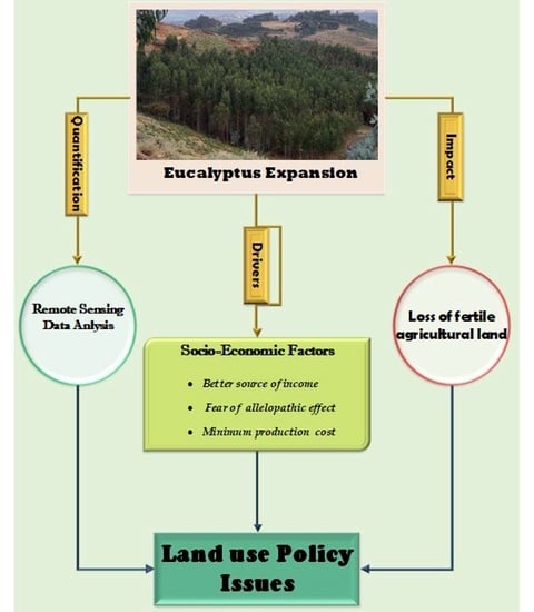
:Converting fertile, cultivated land into Eucalyptus plantations has become a common practice in Ethiopia. Integrating geospatial techniques with socio-economic data analysis can be a useful method to evaluate the expansion of Eucalyptus and its underlying factors. The objective of this study is to detect the spatio-temporal patterns and main factors contributing to Eucalyptus expansion in the Mecha district of Ethiopia. To quantify the spatial extents of Eucalyptus plantations, the study employed Landsat images from 1991 to 2021 with supervised image classification in ERDAS Imagine 2015. In addition, 120 households were chosen using random sampling technique to incorporate socioeconomic factors related to Eucalyptus expansion. The result shows that, Eucalyptus plantations expanded significantly across the study area during the last three decades. Eucalyptus plantation covered 908.87 ha, 3719.05 ha, and 26261.9 ha in 1991, 2006, and 2021, respectively. The increment was mostly at the expense of fertile cultivated land use. The main reasons for its expansion are linked with farmer’s expectations of a better source of income, apprehension about the detrimental effects on nearby cropland, and its affordable production cost. In conclusion, the study area faces challenges from the uncontrolled expansion of Eucalyptus plantations on productive lands. Therefore, careful management and intervention strategies should be established to manage its rapid expansion.
1. Introduction
Land use and land cover change are common phenomena in all parts of the globe, with varying magnitudes. Understanding this crucial scenario, requires attention regarding the ways in which land conditions have shifted and where the changes have taken place. In central Ethiopia, most of the natural ecosystems have shifted to agriculture and human settlement. More recently, the expansion of some exotic tree species such as Eucalyptus woodlots has been a major land use/land cover change [1]. The largest area of land is converted to cropland use, which is susceptible to land degradation and ultimately affects the economic, political, and social units of a nation [2,3]. However, in most countries, including Ethiopia, much of the fertile cropland has been converted to exotic plant species such as Eucalyptus [4,5]. Eucalyptus trees can grow in the tropics, subtropics, and temperate regions, which cover 0.5% of the global forest area [6]. Eucalyptus is the most widely planted genus, covering 22.4% of all planted areas in Africa [3,7]. In Ethiopia, the Eucalyptus tree was introduced in 1894/95 to supply fuelwood and construction wood to the new and growing capital city, Addis Ababa. During the first decade, Eucalyptus was planted and grown in the capital city of Addis Ababa and continued to increase. The next stage, of Eucalyptus growing outside Addis Ababa, was started by missionaries in Ghimbi, DebreTabor, and Harar. Later still, especially after the 1950s, Eucalyptus growth moved to rural areas from these first nodes, being planted first in urban areas, the homesteads, and eventually on agricultural lands by farmers and urban dwellers [3]. The major species grown are Eucalyptus camaldulensis and Eucalyptus globules, which are designated as red and white Eucalyptus, respectively [8,9]. In the early 1970s, it covered about 42,300 ha of the countries land mass; in 1996, 250,000 ha, and by 2002 it had increased to 506,000 ha [10,11,12]. The estimated mean annual increment of Eucalyptus woodlots in Ethiopia is 10–20 m3/ha/year [13].
Eucalyptus is often considered to have undesirable ecological qualities such as depletion of soil water, competent nature for nutrients with other native species, unsuitability for soil erosion control, production of allelopathic chemicals that suppress the growth of other plants, and provision of inadequate food and habitat for wildlife [14]. Replacing natural grassland and bushland with fast growing Eucalyptus could have significant hydrological implications when there exists a variation in water use between the introduced species and the replaced vegetation [15]. Experiments show that planting Eucalyptus causes a significant streamflow reduction when it reaches the third year, and in the ninth year, the stream dried up completely [16]. Several studies have been done on Eucalyptus’ allelopathic effects. Certain species of Eucalyptus emit phenolic acids and volatile oils from their leaves, branches, and roots that are harmful to other plant species [1]. Live plant roots have an extraordinary capacity to produce organic compounds into the rhizosphere that plays crucial roles in interactions with other plant species. Rather than its biological qualities, the primary cause of the detrimental effects is the inadequate management practices used. Nevertheless, Eucalyptus tree plantations are becoming common practice among smallholder farmers in Ethiopia. At present, farmers are replacing their plots of land by Eucalyptus due to its tolerance of fire, insect and browsing animal damage, and its provision of a high yield per hectare due to its short rotation period [1,17,18]. In the Mecha district, there has been a remarkable expansion of Eucalyptus plantations on extensive fertile agricultural land. However, this uncontrolled expansion might be responsible for the reduction in food crop yields [18]. There have been a very limited number of studies conducted focusing on the investigation of spatio-temporal changes in Eucalyptus plantations and their interaction with soil fertility and water utilization [19,20]. However, it is difficult to find a study linking spatio-temporal Eucalyptus expansion with socioeconomic factors.
Understanding the existing information about land use and land cover changes is fundamental for a better understanding of the relationship between the human and the natural environment. With the emergence of geographic information system (GIS) and remote sensing (RS) technology, spatio-temporal changes have been monitored across a variety of aquatic and terrestrial environments including coastal, agricultural, forested, and urban areas [21]. In the past, scientists used field data and aerial photographs to map land use and land cover changes over smaller areas. However, these methods become very costly and time-consuming when the area of interest has large coverage. In recent decades, remote sensing data with multi-temporal satellite imagery has been widely used to quantify and detect land cover information on large geographic extents over time [22,23]. In addition, land use and land cover data coupled with socio-economic data can be very important for obtaining societal perceptions about questions such as ‘why is land use change occurring?’ and ‘so what?’ [24,25]. The integration of socio-economic data and land use and land cover changes improves our understanding of the causes and processes of land use and land cover changes [26]. Therefore, the objective of this study was to evaluate the spatio-temporal expansion of Eucalyptus plantations and identify the major factors that affect farmers to cultivate Eucalyptus trees on their farmland.
2. Materials and Methods
2.1. Description of Study Area
The Mecha district is geographically located between 11°10′ and 11°25′N latitude and 37°02′ and 37°17′E longitude (Figure 1). It is located 525 km northwest of Addis Ababa and 38 km west of Bahir Dar, the capital of the Amhara regional state. The mean monthly minimum and maximum temperatures range from 6.9 °C in January to 13.8 °C in May, respectively. The area’s average annual rainfall is 1270 mm. The Mecha district comprises 12% temperate, 64% alpine, and 24% subalpine climatic zones. The soil type in the Mecha district is characterized by 93% Nitisols, 3% black soil, and 4% gray soil. Nitisols have deep porous and stable soil structure, which allows for deep rooting and creates an ideal environment for the production of food crops such as maize and finger millet, as well as trees such as Eucalyptus [27]. The Mecha district has a total population of 292,080, with 147,611 males and 144,469 females; 22,677, or 7.76%, are urban inhabitants. Its population density is 197.13 persons per square kilometer [28].
2.1.1. Image Data Sources
Landsat satellite images were acquired from United States Geological Survey in 1991, 2006, and 2021 from http://glovis.usgs.gov accessed on 20 January 2020 (Table 1). The study area coverage delimited on single scene, only path 170/row 52 of Land sat images. These images were acquired during the clear sky season (January–February) to reduce atmospheric and radiometric errors. The images were extracted to “Tiff” formats for preprocessing and actual image analysis.
2.1.2. Field Observation
Observation is the conscious noticing and detailed examination of the behavior in a naturalistic setting [29]. So, in this study an intensive field visit was made to closely observe the status of Eucalyptus expansion, which was useful in substantiating the responses obtained by interview; and in validating image classification results. This was made by taking pictures from Eucalyptus plantation fields. In addition, a Global Positioning System (GPS) was used for spatial ground truth point collection, which was used for classification accuracy assessment (Figure 2).
2.1.3. Image Classification Scheme
The major land use and land cover classes found in the study area were identified as forest, Eucalyptus plantations, grazing land, built-up areas of crop (cultivated) land, and waterbody (Table 2). These land uses were identified by modifying the Anderson land use and land cover classification system based on the prior knowledge of the researcher [30]. Eucalyptus plantations were discriminated from other forests using recode function and integration of google earth in ERDAS Imagine menu. Moreover, intensive field observation took place across the study area which was predominantly covered by Eucalyptus.
2.2. Methods of Data Analysis
2.2.1. Image Preprocessing
In remote sensing, preprocessing functions involve the operations required prior to the main data analysis and consist of processes aimed at geometric correction, radiometric correction, and atmospheric corrections to improve the ability to interpret the image components qualitatively and quantitatively for further analysis. Thus, preprocessing is mandatory in most of the document layout analysis and classification operations. The preprocessing may itself be broken into smaller tasks such as line removal, skew estimation and correction, base-line detection (upper and lower), smoothing, and so on. Several methods have been proposed in the literature for estimating the above parameters [31,32]. In this study, the major preprocessing techniques used were layer stacking and sub-setting using ERDAS Imagine 2015. Hence, layer stacking was made to generate single multi-band false color composite images while sub-setting was applied for clipping out the images to the borders of study area (Figure 3).
2.2.2. Image Classification
Image classification is defined as the process of categorizing all pixels in an image or raw remotely sensed satellite data to obtain a given set of labels or land cover themes. There are several approaches and methods that are associated with satellite image classification. However, most widely used satellite image classification methods are unsupervised and supervised techniques [32]. For this study, we employed supervised image classification using the maximum-likelihood parametric decision rule. This technique is better because it automatically classifies all pixels in an image into predefined classes/ themes. This classification approach is achieved using training samples of spectral signatures with the help of visual interpretation.
2.2.3. Change Detection
Change detection is the process of identifying occurrences of targeted changes in a scene, at a given instant time, with the same scene acquired at an earlier instant time. This task consists in finding relevant transitions of one land use into another land use [33,34]. Accordingly, this study made change detection analysis to determine quantities of conversions of different land cover to Eucalyptus during the reference years. Thus, land use change towards Eucalyptus plantation was evaluated at three interval periods: 1st period (1991–2006), 2nd period (2006–2021), and 3rd period (1989–2021). ERDAS Imagine 2015 was used to provide information about area of conversion in raster tab thematic icon matrix union.
2.2.4. Accuracy Assessment
Land cover maps derived from remote sensing imagery always contain some sort of error due to several factors ranging from classification technique to method of satellite data [35]. The study employed producers’ accuracy, users’ accuracy, overall accuracy, and kappa statistics to validate classification ERDAS Imagine 2015. User’s accuracy represents the probability that a given pixel appears on the ground as it is assigned, while producer’s accuracy represents the percentage of a given class that is correctly identified. Whereas, the Kappa coefficient is a measure of agreement between the classified pixel value and the reality [36]. The Kappa statistics were calculated using Equation (1).
where; K = Kappa statics, N = total classified pixels, D = the sum of correctly classified pixels (diagonals), P = total sum of the product of correctly classified pixels with classified total.
To make validation of classified images, a total number of ground truth sample points of 284, 259, and 243 were used for the 1991, 2006, and 2021 images, respectively. In the case of the 1991 and 2006 images, the sample points were collected with supported from local area elders, through asking, “What was there at that time”. For the 2021 classified image, validation was carried out with the support of Google Earth pro software. The test sample points were examined according to each assigned class value to investigate how the results reflected the reality on the ground.
2.2.5. Socio-Economic Sampling Procedure and Sample Size
The study applied a multistage sampling procedure. First, the kebele (lower level of administration) of the study area was stratified into two groups: those who have a large area of Eucalyptus and those with insignificant Eucalyptus cover based on the classification results of the 2021 satellite image. Secondly, three kebeles were chosen out of 39 kebeles that have significant Eucalyptus tree cover. The sample kebeles selected were Kudmi, Inamrt, and Ambomesk, with Eucalyptus plantation coverage of 154.86 ha, 1373.42 ha, and 952.61 ha, respectively. According to information gathered from the district administration office, the three kebeles are home to 3893 (N) households. Out of these, 88% (P) are households with Eucalyptus plantations, while 12% (Q) are households without Eucalyptus plantations. Therefore, using the Cochran [37] approach as given in Equation (2), 120 households were chosen randomly from the lists of households at the kebele administration.
where: n = sample size of housing units (household head); P = household who have agricultural land use; Q = household who have not agricultural land use = 1 − P; N = Total number of housing units; Z = Standardized normal variable and its value that corresponds to 95 % confidence interval equals 1.96; d = Allowable error (0.05).
Figure 4 shows the general framework of the study including input data, techniques and methods employed during the study period.
3. Results
3.1. Accuracy Assessment Results
Table 3 illustrates the total reference point, total classified point number of correctly classified points, producer and user accuracies, and the Kappa statistics. The overall accuracies for all classified images were above the threshold i.e., >85% [38]. Overall accuracy of classified image was 95.42%, 98.07%, and 96.3% during 1991, 2006, and 2021, respectively. The user’s accuracy results range from 91.67–100%, 96.3–100%, and 93.75–100% in 1991, 2006, and 2021, respectively (Table 3). The producer’s accuracy varies from 86.1–100%, 93.3–100%, and 93.3–100% during 1991, 2006, and 2021, respectively (Table 3). This disclosed that only the lowest values of class were misclassified due to spectral property similarities among other land cover classes. Moreover, the Kappa coefficient achieved 0.95, 0.98, and 0.96 in 1991, 2006, and 2021, respectively, which indicates an agreement of the classified image with real land cover.
3.2. Land Use and Land Cover Changes (1991–2021)
Based on image classification result Eucalyptus plantation covered about 908.87 ha (0.6%) in 1991; 3719.05 ha (2.5%) in 2006, and 26,261.9 ha (17.6%) in 2021 respectively (Table 4). Similarly, built-up and water body increased from 72.86 ha (0.1%) to 1570.84 ha (1.1%), and 450.05 ha (0.3%) to 2051.3 ha (1.4%) between 1991 and 2021, respectively. However, cultivated land coverage declined from 87,613.6 ha (58.6%) to 68,561.52 ha (45.9%) between 1991 and 2021 (Table 4). In addition, grazing land and forestland showed a decreasing trend which covered 50,237.32 ha (33.6%), 49,161.2 ha (32.9%), and 40,927.52 ha (27.4%) in 1991, 2006, and 2021, respectively (Table 4).
3.3. Driving Factor of Eucalyptus Expansion
There are different factors responsible for the expansion of Eucalyptus plantations; the major ones are the desirable price of the tree over food crops, fear for crop yield reduction due to adjacent Eucalyptus plantations, and low production cost (Table 5). In the study area, around 45.8 % of respondent farmers choose to plant Eucalyptus on their plots, hoping to generates better income (Table 5). While, 27.5% of the respondents replied that farmers were forced to change their land to Eucalyptus due to the fear of its negative impacts from nearby croplands covered with the plant (Table 5). The remaining 18.3% of the respondent specified that farmers had planted Eucalyptus due to its low cost of production, and short growing and harvest time (Table 5). The majority of the respondents (97.5%) replied that cropland which the most commonly converted land use to Eucalyptus (Table 5).
4. Discussion
Expansion of Eucalyptus Plantation
Image classification result presented that there was dramatic expansion of Eucalyptus plantation in the Mecha district during the last three decades, as indicated in Table 4. This expansion was due to transformation and/or modification from other land use and land cover types to Eucalyptus largely cultivated land use (Figure 5).
Change detection results revealed that there was significant conversion of different land uses into Eucalyptus plantation. The highest share of conversion was primarily at the expense of extensive fertile cultivated land (Figure 5 and Figure 6). Eucalyptus expanded on 2513.13 ha, 25,043.53 ha, and 24,447.71 ha cultivated land during the 1st period, the 2nd period, and the 3rd period, respectively (Figure 5 and Table 6). In the first period (1991–2006), expansion was limited to agricultural land closer to the homestead, and later productive croplands altered into Eucalyptus woodlots (Figure 2). This result agrees with the study reported by Biru et al. [39] in Koga watershed, which states that there is a rising trend in forest cover that is associated with the quick growth of Eucalyptus plantations. Another investigation in Southern Ethiopia described how growing Eucalyptus at a farm level in the form of woodlot has become common practice among rural households in Southern Ethiopia [40]. The finding is also in agreement with the report of Jenbere et al. [5]; for example, in south central parts of Ethiopia Arsi-Negele district, Eucalyptus plantation is rapidly expanding in fertile agricultural land. Accordingly, the rate of Eucalyptus plantation is the most dominant species and has been planted over 95 countries in the world [41]. Lal [42] identified that in India, forest and farmlands, community lands and road/rail/canal strips have been transformed to large-scale Eucalyptus plantations to satisfy fuel shortage. A study in China also indicates that China were ranked first in the world in the mid-1990s in terms of expansion of Eucalyptus plantations, due to the short logging/rotation period for production of timber [43]. The same report has been published by Merino et al. [44] in southern Europe, stating that forest plantations are dominated by fast growing species such as Eucalyptus which can grow on acidic soils. The major reason for its expansion is that people are highly dependent on the multi-functionality of the tree. Unless masonry construction is used, the only tree source used for house construction is Eucalyptus. Even the masonry buildings are consuming a large volume of Eucalyptus to support the construction. Dessie et al. [45] indicated that 92% of the construction industry was covered by Eucalyptus. This makes the tree worth more income from the sale of the tree. A study in central Ethiopia indicated that Eucalyptus covers 75% of the firewood sold in the market and about 25% of the income source for livelihood [46]. From its very nature, the tree has a very wide adaptation to the different agro-ecological zones in the country, and is fast growing, resulting in rapid plantation of Eucalyptus by smallholders. More surprisingly, unlike other tree species Eucalyptus is non-palatable by livestock. Plantation efforts were made every year with a government-sponsored campaign; however, the success rate is marginal.
Moreover, about 1009.75 ha, 1029.94 ha, and 1151.45 ha of grazing land use was transformed to Eucalyptus in the first, second, and the third periods, respectively. This finding corresponds with Lemenh et al. [46] which indicated that there was substantial expansion of Eucalyptus plantation on grazing and bushland areas in different parts of Ethiopia. The finding is also supported by reports of Jaleta et al. [1] who presented that there was an increase in Eucalyptus coverage in central Ethiopia at the expense of grassland and bush land, driven by the demand for fuel wood and construction materials, the rising of the market, and profit gained from the wood products. A similar report, presented that in Uruguay commercial Eucalyptus plantations have increased during the last decade due to conversion of natural grazed pastures [47]. Figure 5 and Table 6, indicates that 108.64 ha, 113.72 ha, and 566.18 ha of forest land was also converted into Eucalyptus plantation in the first, second, and the third period, respectively. The results are also congruent with the findings of Bayle [17], which show that the expansion of Eucalyptus plantation because of the depletion of natural forests by other land uses such as farming practice leads to the shortage of fuel wood; and its ability to grow in areas where other forest species cannot persist. Yet, the transformation of built-up areas and waterbodies into Eucalyptus plantation were not significate during the study period.
The result of remote sensing data proved that there was rapid expansion of Eucalyptus plantation during the past three decades in the Mecha district. The major factors for expansion of Eucalyptus plantation are the desirable price of the tree over food crops, fear for crop yield reduction due to adjacent Eucalyptus plantation, and low production cost (Table 5). Around 45.8% of respondent farmers prefer planting Eucalyptus on their plots, hoping to generates better income (Table 5). This finding agrees with the study by Zerga [48] indicating that recently Eucalyptus is becoming an immediate source of money for various expenses for farmers. Similarly, a study in the Tigray region Ethiopia, indicated that the main factors influencing household or community decisions to invest in Eucalyptus tree growing is due to its low-cost requirement and a high yield, especially where it is planted on croplands [49]. Furthermore, Desta et al. [50] also indicated that farmers planted Eucalyptus expecting a better return, although, its price is becoming marginal as compared to crops and livestock. Besides, 27.5% of the respondents reacted that farmers were forced to change their land to Eucalyptus due to the fear of its negative impacts from nearby croplands covered with the plant (Table 5). This was investigated by Chanie et al. [18], who indicated that the production of crops where Eucalyptus is planted in the adjacent cropland as a Eucalyptus plantation creates high competition for nutrients, shadow effects, and competition for water. Another experimental investigation supported the finding that finger millet and maize yield suffered as a result of Eucalyptus over-competition with crops cultivated in the nearby croplands [27]. The other 18.3% of the respondents indicated that farmers planted Eucalyptus because it requires low cost of production and needs a short growing and harvest time, as indicated (Table 6). The same report has been published by [44] in southern Europe, stating that, forest plantations are dominated by fast growing species such as Eucalyptus, which can grow on acidic soils. It is also supported by a study done in China which shows that Eucalyptus coverage increased because of its fastest growing and high-yielding qualities, as well as its high tolerance to infertile soil [43]. A total of 97.5% of the respondents agreed that cropland is mostly subject to conversion into Eucalyptus plantation. The result corresponds with the classified image outcome, which shows that the principal change was observed from cultivated land use (Table 6 and Figure 7). Thus, the results imply that large hectares of fertile cropland is converted into Eucalyptus plantation. This is supported by the same study in the North-Western highlands of Ethiopia by Tesfaw et al. [51].
Despite the multi-level benefits and rapid expansion of Eucalyptus plantations, there are still opposing opinions among practitioners and policymakers on the advantages and disadvantages of planting Eucalyptus [50,51,52,53,54]. With the existing conflicting ideas from various perspectives, an idea that brings both sides together is critical. According to Gil et al. [54], Eucalyptus has negative impacts when it is planted to replace existing natural forests and is then poorly managed. In contrast, it would have a positive impact if planted in degraded areas under good management. Currently, raising Eucalyptus seedlings from government nursery sites is not encouraging. However, most farmers understand the merits and demerits of Eucalyptus. Most of the time, farmers need short-term benefits from plantations and other development interventions. As a result, farmers prefer to raise Eucalyptus seedlings on their own plots of land and sell them in the local market [55,56]. The primary source of household income in most households is the sale of Eucalyptus seedlings and wood lots. It is possible to say that, there is no smallholder farmer who does not have a Eucalyptus tree in the study district, even in Ethiopia. In addition, planting Eucalyptus is considered an employment opportunity for unemployed youth and women. There is a current argument that degraded areas are home to unemployed and landless youths. These lands are mostly communal and can be used as a means to create job opportunities for income generation [57]. Low-income countries, such as Ethiopia, should encourage Eucalyptus plantations since it is the backbone of smallholder farmers’ livelihoods, and should develop legislation to encourage the adoption of fast-growing tree species such as Eucalyptus that meet the growing demand for firewood, construction materials, and timber to prevent further degradation of natural forests. Furthermore, Eucalyptus could contribute to rural development and poverty reduction [49]. Sustainable land resource management can be achieved through sound land use planning. With a rapidly growing population, land is a serious and sensitive economic sector for rural and peri-urban areas. Ethiopia as a nation has a land use planning policy under proclamation number 456/2005. However, the implementation of the policy is hampered by the lack of integration among stakeholders, follow-up capacity, rule enforcement, and regulatory mechanisms. Implementing institutions at all levels are expected to require the capacity to develop regulations and reinforce existing rules. In addition, regulating the expansion of exotic species should also be monitored along with the land use policy. For example, Eucalyptus is a widely planted tree species that would be managed properly to harmonize its impact from different perspectives. In order to reduce the challenges and enhance its productivity, strict regulations should be maintained. Such decisions shall be supported by research results reported by different scholars. The rate of Eucalyptus plantation and its expansion from fertile cropland, according to this study, is an unregulated practice. In order to enhance the implementing partner organizations and decision-makers’ skills and capacities, research outputs are fundamental. Thus, the results of this study can support decision-makers, land planners, and local governments to apply appropriate land management policies and strategies. In particular, such site-specific information enables the local government to understand the issue and needs critical action. Moreover, it is crucial to start action on selecting the appropriate land use through communication among stakeholders including the landowners. It is obvious that fertile croplands will be preserved because they are critical land uses for combating food insecurity, whereas perennial tree crops such as Eucalyptus shall be grown in degraded areas to maintain ecosystem services and restore degraded areas.
5. Conclusions
In the study district, Eucalyptus tree plantation is the most common practice referred to by farmers. The study revealed that Eucalyptus plantation coverage increased rapidly over the last three decades. It increased from 908.87 ha to 26,261.9 ha (17.6%) between 1991 and 2021, which is around twenty-nine times the earlier year. This increment was mainly at the expense of 24,447.71 ha of cultivated land followed by 1151.45 ha of grazing and 566.18 ha of forest land use during 1991–2021. The observed expansion was due to various factors such as fear of its negative impact on the productivity of adjacent cropland and affordable cost of production as compared to other land uses. There are varies opinions on the advantages and disadvantages of planting Eucalyptus. However, the advantages of planting Eucalyptus outweigh the benefits a smallholder gains from other land uses. Many agree on planting the tree in degraded areas with proper management methods. Otherwise, it seems challenging to discourage the practice without putting in place an alternative means of livelihood support. Hence, further investigation into the impacts of Eucalyptus, especially the interaction between Eucalyptus and soil, water, nutrients, and others through experimentation is required, to reach a reasonable utilization of the resource among policy makers and user communities. Beyond doubt, the results of this study can support decision-makers, land planners, and the local government in applying appropriate land management policies and strategies.
Author Contributions
G.M. Conceptualization; G.M. and M.B.A. methodology; G.M., M.B.A. and G.T.A. formal analysis; G.M. writing the original draft preparation; M.B.A. and G.T.A. review and editing; G.T.A. funding acquisition. All authors have read and agreed to the published version of the manuscript.
Funding
This research received no external funding. Gebiaw T. Ayele covered the APC and received funding from Griffith Graduate Research School, the Australian Rivers Institute and School of Engineering, Griffith University, Queensland, Australia.
Data Availability Statement
The data presented in this study are available on the tables and figures presented in the manuscript.
Acknowledgments
It is grateful to all those who had contributed for the research work in the study area and especial thanks goes to Daniel Asfaw who supported during data collection. Gebiaw T. Ayele acknowledges Griffith Graduate Research School, the Australian Rivers Institute and School of Engineering, Griffith University, Queensland, Australia.
Conflicts of Interest
The authors declare no conflict of interest.
References
- Jaleta, D.; Mbilinyi, B.; Mahoo, H.; Lemenih, M. Evaluation of land use/land cover changes and Eucalyptus expansion in Meja watershed, Ethiopia. J. Geogr. Environ. Earth Sci. Int. 2016, 7, 1–12. [Google Scholar] [CrossRef]
- Desalegn, T.; Cruz, F.; Kindu, M.; Turrión, M.-B.; Gonzalo, J. Land-use/land-cover (LULC) change and socioeconomic conditions of local community in the central highlands of Ethiopia. Int. J. Sustain. Dev. World Ecol. 2014, 21, 406–413. [Google Scholar] [CrossRef]
- Yitaferu, B.; Abewa, A.; Amare, T. Expansion of eucalyptus woodlots in the fertile soils of the highlands of Ethiopia: Could it be a treat on future cropland use? J. Agric. Sci. 2013, 5, 97. [Google Scholar] [CrossRef]
- Anteneh, W.; Dejen, E.; Getahun, A. Shesher and Welala floodplain wetlands (Lake Tana, Ethiopia): Are they important breeding habitats for Clarias gariepinus and the migratory Labeobarbus fish species? Sci. World J. 2012, 2012, 298742. [Google Scholar] [CrossRef] [PubMed] [Green Version]
- Jenbere, D.; Lemenih, M.; Kassa, H. Expansion of eucalypt farm forestry and its determinants in Arsi Negelle District, South Central Ethiopia. Small-Scale For. 2012, 11, 389–405. [Google Scholar] [CrossRef] [Green Version]
- Chidumayo, E.N.; Gumbo, D.J. The Dry Forests and Woodlands of Africa; Earthscan: London, UK; Washington, DC, USA, 2010. [Google Scholar]
- Abebe, M.; Tadesse, W. Eucalyptus in Ethiopia Risk or Opportunity? Ethiopian Institute of Agricultural Research: Addis Ababa, Ethiopia, 2014.
- Amare, G. Eucalyptus farming in Ethiopia: The case of Eucalyptus farm and village woodlots in Amhara Region. In 2002 Bahir Dar Conference Proceedings; Ethiopian Society of Soil Science: Bahir Dar, Ethiopia, 2002; pp. 137–153. [Google Scholar]
- Bekele, T. Integrated Utilization of Eucalyptus globulus grown on the Ethiopian Highlands and its Contributionto Rural Livelihood: A Case Study of Oromia, Amhara and Southern Nations Nationalities and People’s Regional State Ethiopia. Int. J. Basic Appl. Sci. 2015, 4, 80–87. [Google Scholar]
- Getahun, A. Eucalyptus Farming in Ethiopia: The Case for Eucalyptus Woodlots in the Amhara Region; FAO: Rome, Italy, 2003. [Google Scholar]
- Dessie, G. Eucalyptus in East Africa: Socio-Economic and Environmental Issues; International Water Management Institute: Colombo, Sri Lanka, 2011. [Google Scholar]
- Bekele, M. Forest plantations and woodlots in Ethiopia. Afr. For. Forum Work. Pap. Ser. 2011, 1, 1–51. [Google Scholar]
- Zegeye, H. Environmental and socio-economic implications of Eucalyptus in Ethiopia. Ethiop. Inst. Agric. Res. 2010, 15, 184–205. [Google Scholar]
- Stanturf, J.A.; Vance, E.D.; Fox, T.R.; Kirst, M. Eucalyptus beyond its native range: Environmental issues in exotic bioenergy plantations. Int. J. For. Res. 2013, 2013, 463030. [Google Scholar] [CrossRef]
- Scott, D.F.; Lesch, W. Streamflow responses to afforestation with Eucalyptus grandis and Pinus patula and to felling in the Mokobulaan experimental catchments, South Africa. J. Hydrol. 1997, 199, 360–377. [Google Scholar] [CrossRef]
- Sasikumar, B. Rosemary. In Handbook of Herbs and Spices; Elsevier: Amsterdam, The Netherlands, 2012; pp. 452–468. [Google Scholar]
- Bayle, G. Ecological and social impacts of eucalyptus tree plantation on the environment. J. Biodivers. Conserv. Bioresour. Manag. 2019, 5, 93–104. [Google Scholar] [CrossRef] [Green Version]
- Chanie, T.; Collick, A.S.; Adgo, E.; Lehmann, C.J.; Steenhuis, T.S. Eco-hydrological impacts of Eucalyptus in the semi humid Ethiopian Highlands: The Lake Tana Plain. J. Hydrol. Hydromech. 2013, 61, 21. [Google Scholar] [CrossRef] [Green Version]
- Tadele, D.; Assefa, A.; Teketay, D. Effect of Eucalyptus camaldulensis stand Conversion into Crop Production on Growth and Yield of Maize: The case of Koga Watershed Areas in northwestern Ethiopia. Momona Ethiop. J. Sci. 2014, 6, 58–69. [Google Scholar] [CrossRef]
- Wiatkowska, B.; Słodczyk, J.; Stokowska, A. Spatial-Temporal Land Use and Land Cover Changes in Urban Areas Using Remote Sensing Images and GIS Analysis: The Case Study of Opole, Poland. Geosciences 2021, 11, 312. [Google Scholar] [CrossRef]
- Temesgen, G.; Amare, B.; Silassie, H. Land degradation in Ethiopia: Causes, impacts and rehabilitation techniques. J. Environ. Earth Sci. 2014, 4, 98–104. [Google Scholar]
- Berlanga-Robles, C.A.; Ruiz-Luna, A. Land use mapping and change detection in the coastal zone of northwest Mexico using remote sensing techniques. J. Coast. Res. 2002, 18, 514–522. [Google Scholar]
- Fonji, S.F.; Taff, G.N. Using satellite data to monitor land-use land-cover change in North-eastern Latvia. Springerplus 2014, 3, 1–15. [Google Scholar] [CrossRef] [PubMed] [Green Version]
- Klintenberg, P.; Seely, M.; Christiansson, C. Local and national perceptions of environmental change in central Northern Namibia: Do they correspond? J. Arid. Environ. 2007, 69, 506–525. [Google Scholar] [CrossRef]
- Sertel, E.; Findik, N.; Kaya, S.; Seker, D.; Samsunlu, A. Assessment of landscape changes in the Kizilirmak Delta, Turkey, using remotely sensed data and GIS. Environ. Eng. Sci. 2008, 25, 353–362. [Google Scholar] [CrossRef]
- Mertens, B.; Sunderlin, W.D.; Ndoye, O.; Lambin, E.F. Impact of macroeconomic change on deforestation in South Cameroon: Integration of household survey and remotely-sensed data. World Dev. 2000, 28, 983–999. [Google Scholar] [CrossRef]
- Alebachew, M.; Amare, T.; Wendie, M. Investigation of the Effects of Eucalyptus camaldulensis on Performance of Neighbouring Crop Productivity in Western Amhara, Ethiopia. Open Access Libr. J. 2015, 2, 1. [Google Scholar] [CrossRef]
- Central Statistics Agency. The 2007 Population and Housing Census of Ethiopia; Central Statistics Agency: Addis Ababa, Ethiopia, 2010.
- Cowie, N. Observation, in Qualitative Research in Applied Linguistics; Springer: Berlin/Heidelberg, Germany, 2009; pp. 165–181. [Google Scholar]
- Anderson, J.R.; Hardy, E.E.; Roach, J.T.; Witmer, R.E. A Land Use and Land Cover Classification System for Use with Remote Sensor Data; Professional Paper; US Government Printing Office: Washington, DC, USA, 1976.
- Gross, R.; Brajovic, V. An Image Preprocessing Algorithm for Illumination Invariant Face Recognition. In International Conference on Audio- and Video-Based Biometric Person Authentication; Springer: Berlin/Heidelberg, Germany, 2003. [Google Scholar]
- Dhingra, S.; Kumar, D. A review of remotely sensed satellite image classification. Int. J. Electr. Comput. Eng. 2019, 9, 1720. [Google Scholar] [CrossRef]
- Sahbi, H.; Deschamps, S.; Stoian, A. Active learning for interactive satellite image change detection. arXiv 2021, arXiv:2110.04250. [Google Scholar]
- Samal, D.R.; Gedam, S.S. Monitoring land use changes associated with urbanization: An object based image analysis approach. Eur. J. Remote Sens. 2015, 48, 85–99. [Google Scholar] [CrossRef]
- Rogan, J.; Chen, D. Remote sensing technology for mapping and monitoring land-cover and land-use change. Prog. Plan. 2004, 61, 301–325. [Google Scholar] [CrossRef]
- Foody, G.M. Sample size determination for image classification accuracy assessment and comparison. Int. J. Remote Sens. 2009, 30, 5273–5291. [Google Scholar] [CrossRef]
- Cochran, J.; Heinrich, B.; Baartman, R. 24 GHz transmission studies on the amorphous alloy METGLAS 2826 from 26 to 270 °C. Physica B+C 1977, 86, 807–809. [Google Scholar] [CrossRef]
- Congalton, R.G. A review of assessing the accuracy of classifications of remotely sensed data. Remote Sens. Environ. 1991, 37, 35–46. [Google Scholar] [CrossRef]
- Biru, M.K.; Minale, A.; Debay, A. Multitemporal land use land cover change and dynamics of Blue Nile Basin by using GIS and remote sensing techniques, north-western Ethiopia. Int. J. Environ. Sci. 2015, 4, 81–88. [Google Scholar]
- Gizachew, K. Expansion of eucalypt woodlot and its factors in Cheha District, Southern Ethiopia. World Sci. News 2017, 66, 163–180. [Google Scholar]
- Hua, L.S.; Chen, L.W.; Antov, P.; Kristak, L.; Tahir, P.M. Engineering Wood Products from Eucalyptus spp. Adv. Mater. Sci. Eng. 2022, 2022, 8000780. [Google Scholar]
- Lal, P. Clonal eucalyptus plantations in India. In ACIAR PROCEEDINGS; ACIAR: Canberra, Australia, 2003. [Google Scholar]
- Zhang, Y.; Wang, X. Geographical spatial distribution and productivity dynamic change of eucalyptus plantations in China. Sci. Rep. 2021, 11, 1–15. [Google Scholar] [CrossRef] [PubMed]
- Merino, A.; Balboa, M.; Soalleiro, R.R.; González, J. Nutrient exports under different harvesting regimes in fast-growing forest plantations in southern Europe. For. Ecol. Manag. 2005, 207, 325–339. [Google Scholar] [CrossRef]
- Dessie, A.B.; Abate, T.; Mekie, T. Eucalyptus: The popular exotic tree crop in Ethiopia. Acta Sci. Agric. 2019, 3, 50–56. [Google Scholar] [CrossRef]
- Lemenh, M.; Campbell, B. The role and management of Eucalyptus in Lode Hetosa District, Central Ethiopia. For. Trees Livelihoods 2007, 17, 309–323. [Google Scholar]
- Sicardi, M.; Garcı, F.; Frioni, L. Soil microbial indicators sensitive to land use conversion from pastures to commercial Eucalyptus grandis (Hill ex Maiden) plantations in Uruguay. Appl. Soil Ecol. 2004, 27, 125–133. [Google Scholar] [CrossRef]
- Zerga, B. Ecological impacts of Eucalyptus plantation in eza wereda, Ethiopia. Int. Inv. J. Agric. Soil Sci. 2015, 3, 47–51. [Google Scholar]
- Jagger, P.; Pender, J. The role of trees for sustainable management of less-favored lands: The case of eucalyptus in Ethiopia. For. Policy Econ. 2003, 5, 83–95. [Google Scholar] [CrossRef] [Green Version]
- Desta, T.T.; Teklemariam, H.; Mulugeta, T. Insights of smallholder farmers on the trade-offs of eucalyptus plantation. Environ. Chall. 2023, 10, 100663. [Google Scholar] [CrossRef]
- Tesfaw, A.; Senbeta, F.; Alemu, D.; Teferi, E. Value Chain Analysis of Eucalyptus Wood Products in the Blue Nile Highlands of Northwestern Ethiopia. Sustainability 2021, 13, 12819. [Google Scholar] [CrossRef]
- Waldy, J.; Kershaw, J.A.; Weiskittel, A.; Ducey, M.J. Comparison of time-based versus state–space stand growth models for tropical hybrid Eucalyptus clonal plantations in Sumatera, Indonesia. Can. J. For. Res. 2021, 51, 1178–1187. [Google Scholar] [CrossRef]
- Seware, B.Z.; Dullo, B.W.; Fanta, D.T.; Abshare, M.W. Environmental Impacts of Eucalypt Plantations in the Western Gurage Watersheds, Central-South Ethiopia. 2021. Available online: http://collections.unu.edu/eserv/UNU:8238/n1-s2.0-S2666719321000261-main.pdf (accessed on 1 October 2022).
- Gil, L.; Tadesse, W.; Tolosana, E.; López, R. Eucalyptus Species Management, History, Status, and Trends in Ethiopia; Ethiopian Institute of Agricultural Research (EIAR): Addis Ababa, Ethiopia, 2010.
- Derero, A. Toward a Tree Seed System That Guarantees Quality and Satisfies Demand in Ethiopia; Derero, A., Fantu, W., Eshetu, Z., Eds.; Trends in tree seed systems in Ethiopia; EIAR: Addis Ababa, Ethiopia, 2011; pp. 43–56.
- Oduol, J.; Nang’ole, E. Economic and market assessment of agroforestry options in Ethiopia. 2012. Available online: https://www.researchgate.net/profile/Judith-Beatrice-Oduol-2/publication/266089052_Economic_and_Market_Assessment_of_Agroforestry_Options_in_Ethiopia_A_Case_study_of_Jeldu_Diga_and_Fogera_Districts/links/5425505a0cf26120b7ac8c93/Economic-and-Market-Assessment-of-Agroforestry-Options-in-Ethiopia-A-Case-study-of-Jeldu-Diga-and-Fogera-Districts.pdf (accessed on 1 October 2022).
- Alebachew, M. Traditional Agroforestry practices, opportunities, threats and research needs in the highlands of Oromia, Central Ethiopia. IRJAS 2012, 2, 194–206. [Google Scholar]
Figure 1.
Location map of the study area, Mecha district.

Figure 2.
Eucalyptus woodlots encroaching on cultivated fields (a) and GPS point data collection (b).
Figure 2.
Eucalyptus woodlots encroaching on cultivated fields (a) and GPS point data collection (b).

Figure 3.
Landsat image False Color Composite of the study area (a) 1991, (b) 2006 and (c) 2021.

Figure 4.
Methodological Flowchart implemented for the study.

Figure 5.
Land use transitions towards Eucalyptus plantation for the three periods.

Figure 6.
Spatial coverage of Eucalyptus plantation in the study area (a) 1991 (b) 2006 and (c) 2021.
Figure 6.
Spatial coverage of Eucalyptus plantation in the study area (a) 1991 (b) 2006 and (c) 2021.

Figure 7.
The conversion trends of different land use towards Eucalyptus: (a) 1991–2006, (b) 2006–2021 and (c) 1991–2021.
Figure 7.
The conversion trends of different land use towards Eucalyptus: (a) 1991–2006, (b) 2006–2021 and (c) 1991–2021.


Table 1.
Types of satellite image.
| Satellite Data | Date | Spatial Resolution | Source |
|---|---|---|---|
| Landsat 5 MSS | 1 February 1991 | 30 m | Global Land Cover Facility (GLCF) |
| Land sat 7 TM | 8 February 2006 | 30 m | Global Land Cover Facility (GLCF) |
| Landsat 7 ETM+ | 12 February 2021 | 30 m | Global Land Cover Facility (GLCF) |
Table 2.
Characteristics of identified land cover classes in the study area.
| Class Name | Description |
|---|---|
| Forest | Land use/land cover, which is covered by natural and artificial forests excluding Eucalyptus. |
| Eucalyptus | Areas covered with growth mainly Eucalyptus and other mixed crops |
| Grazing Land | Areas used for grazing, as well as bare lands (or rocks) with little or no grass cover, bushes, or shrubs. |
| Built-up areas | Residential areas including educational, health, and socio-economic facilities, and shops; especially urban areas. |
| Cropland | Areas used for crop cultivation, especially cereal crops (Teff, Wheat, Barley, etc.) and different scattered settlements. |
| Waterbody | Lakes and rivers, and waterlogged and swampy areas throughout the year. |
Table 3.
Accuracy assessment for 1991, 2006, and 2021 classified image.
| Classified Data | Reference Totals | Classified Totals | Number Correct | Producers Accuracy (%) | Users Accuracy (%) | |
|---|---|---|---|---|---|---|
| 1991 | Forest | 46 | 42 | 42 | 91.3 | 100 |
| Eucalyptus | 48 | 48 | 44 | 91.67 | 91.67 | |
| Grazing land | 54 | 59 | 54 | 100 | 91.53 | |
| Built-up area | 36 | 31 | 31 | 86.1 | 100 | |
| Cultivated land | 54 | 58 | 54 | 100 | 93.1 | |
| Waterbody | 46 | 46 | 46 | 100 | 100 | |
| Total | 284 | 284 | 271 | |||
| 2006 | Forest | 33 | 33 | 32 | 96.97 | 96.97 |
| Eucalyptus | 48 | 48 | 47 | 97.92 | 97.92 | |
| Grazing land | 47 | 48 | 47 | 100 | 97.92 | |
| Built-up area | 48 | 48 | 48 | 100 | 100 | |
| Cultivated land | 53 | 54 | 52 | 98.11 | 96.3 | |
| Waterbody | 30 | 28 | 28 | 93.3 | 100 | |
| Total | 259 | 259 | 254 | |||
| 2021 | Forest | 45 | 42 | 42 | 93.3 | 100 |
| Eucalyptus | 48 | 51 | 48 | 100 | 94.12 | |
| Grazing land | 48 | 49 | 46 | 95.83 | 93.88 | |
| Built-up area | 34 | 33 | 33 | 97.06 | 100 | |
| Cultivated land | 46 | 48 | 45 | 97.83 | 93.75 | |
| Waterbody | 22 | 20 | 20 | 90.91 | 100 | |
| Total | 243 | 243 | 234 |
Table 4.
Area of land use classes in ha in 1991, 2006, and 2021.
| Land Use Class | 1991 | 2006 | 2021 | |||
|---|---|---|---|---|---|---|
| Area (ha) | % | Area (ha) | % | Area (ha) | % | |
| Forest | 10,158.47 | 6.8 | 10,670.9 | 7.1 | 10,068.1 | 6.7 |
| Eucalyptus | 908.87 | 0.6 | 3719.05 | 2.5 | 26,261.9 | 17.6 |
| Grazing land | 50,237.32 | 33.6 | 49,161.20 | 32.9 | 40,927.52 | 27.4 |
| Built-up area | 72.86 | 0.1 | 126.94 | 0.1 | 1570.84 | 1.1 |
| Cultivated land | 87,613.6 | 58.6 | 85,644.96 | 57.3 | 68,561.52 | 45.9 |
| Water body | 450.05 | 0.3 | 118.13 | 0.1 | 2051.3 | 1.4 |
| Total | 149,441.2 | 100 | 149,441.2 | 100 | 149,441.2 | 100 |
Table 5.
Driving factors for expansions of Eucalyptus plantation.
| Number of Respondents | Percent | |
|---|---|---|
| Drivers for the expansions of Eucalyptus farming | ||
| An increasing price of wood products in the market | 9 | 7.5 |
| Yields better income than other land use products | 55 | 45.8 |
| Low Production Cost | 22 | 18.3 |
| Guarantee for their ownership of land | 1 | 0.8 |
| Fear for adjacent crop yield reduction | 33 | 27.5 |
| Land use mostly converted to Eucalyptus | ||
| Crop land | 117 | 97.5 |
| Residential area | 3 | 2.5 |
| Grazing land | 0 | 0 |
| Total | 120 | 100 |
Table 6.
The spatial conversions of different land use towards Eucalyptus (1991–2021).
| Land Use Classes | Eucalyptus Plantation (ha) | ||
|---|---|---|---|
| 1st Period | 2nd Period | 3rd Period | |
| Forest | 108.64 | 113.72 | 566.18 |
| Eucalyptus | 85.41 | 72.86 | 94.52 |
| Grazing land | 1009.75 | 1029.94 | 1151.45 |
| Built-up area | 0.05 | 0.48 | 0.52 |
| Cultivated land | 2513.13 | 25,043.53 | 24,447.71 |
| Water body | 2.07 | 1.37 | 1.52 |
| Total | 3719.05 | 26,261.90 | 26,261.90 |
Disclaimer/Publisher’s Note: The statements, opinions and data contained in all publications are solely those of the individual author(s) and contributor(s) and not of MDPI and/or the editor(s). MDPI and/or the editor(s) disclaim responsibility for any injury to people or property resulting from any ideas, methods, instructions or products referred to in the content. |
© 2023 by the authors. Licensee MDPI, Basel, Switzerland. This article is an open access article distributed under the terms and conditions of the Creative Commons Attribution (CC BY) license (https://creativecommons.org/licenses/by/4.0/).
Share and Cite
MDPI and ACS Style
Molla, G.; Addisie, M.B.; Ayele, G.T. Expansion of Eucalyptus Plantation on Fertile Cultivated Lands in the North-Western Highlands of Ethiopia. Remote Sens. 2023, 15, 661. https://doi.org/10.3390/rs15030661
AMA Style
Molla G, Addisie MB, Ayele GT. Expansion of Eucalyptus Plantation on Fertile Cultivated Lands in the North-Western Highlands of Ethiopia. Remote Sensing. 2023; 15(3):661. https://doi.org/10.3390/rs15030661
Chicago/Turabian StyleMolla, Gashaw, Meseret B. Addisie, and Gebiaw T. Ayele. 2023. "Expansion of Eucalyptus Plantation on Fertile Cultivated Lands in the North-Western Highlands of Ethiopia" Remote Sensing 15, no. 3: 661. https://doi.org/10.3390/rs15030661
Note that from the first issue of 2016, this journal uses article numbers instead of page numbers. See further details here.