Article

A Study on Pseudorange Biases in BDS B1I/B3I Signals and the Impacts on Beidou Wide Area Differential Services

1
Shanghai Astronomical Observatory, Chinese Academy of Sciences, Shanghai 200030, China
2
University of Chinese Academy of Sciences, Beijing 100049, China
3
Beijing Satellite Navigation Center, Beijing 100094, China
*
Author to whom correspondence should be addressed.
Remote Sens. 2022, 14(3), 432; https://doi.org/10.3390/rs14030432
Submission received: 16 December 2021 / Revised: 11 January 2022 / Accepted: 11 January 2022 / Published: 18 January 2022
(This article belongs to the Special Issue Beidou/GNSS Precise Positioning and Atmospheric Modeling)

Abstract

:
Due to satellite signal deformations, there are different constant biases in the same satellite signal that are measured by different technical types of receivers and different satellite signals that are measured by the same type of receiver, which are named pseudorange biases. These biases cannot be transmitted to users with existing navigation parameters, such as satellite time group delay (TGD) and receiver differential code biases (DCB). With the improvement of the signal-in-space accuracy of the Global Navigation Satellite System (GNSS), the pseudorange bias has become one of the primary error sources affecting the accuracy of GNSS services. To ensure the accuracy for users under the wide area differential services (WADS), we extracted the pseudorange biases of Beidou Satellite Navigation System (BDS) B1I, B3I and B1I/B3I signals and analyzed the impact of those biases on users under the WADS. Finally, we tried to eliminate this influence. The results show that the pseudorange biases of the B3I signal are smaller than those of the B1I signal at the centimeter level, but the pseudorange biases of the B1I/B3I signal can reach the meter level. Due to the large pseudorange bias of the B1I/B3I signal, the average user equivalent ranging error (UERE) under the WADS is 1.19 m, which is no better than the average UERE under open services (OS). Influenced by the pseudorange biases, the average positioning accuracies of the B1I/B3I signal are 4.17 m and 4.24 m under the WADS and the OS. When the pseudorange biases are deducted, these accuracies are 3.03 m and 3.50 m, respectively.

Graphical Abstract

1. Introduction

To improve the accuracy and integrity of satellite navigation, many countries and regions have established satellite-based augmentation systems, such as the Wide Area Augmentation System (WAAS) in the United States, the European Geostationary Navigation Overlay Service (EGNOS) in Europe, the MTSAT Satellite-based Augmentation System (MSAS) in Japan and Global Positioning System (GPS)-aided geostationary Earth orbit (GEO) Augmented Navigation (GAGAN) in India [1,2,3,4]. Satellite-based augmentation systems track navigation satellites in real time using monitoring receivers located in service areas, calculate corrections, including satellite orbit and clock offset corrections and the corresponding integrity information, and then broadcast augmentation messages through GEO satellites [5]. WAAS users in most service areas can obtain positioning accuracies of better than 1.0 m and 1.5 m in the horizontal and vertical directions, respectively. The EGNOS system provides users in Europe with a positioning accuracy within 1.5 m and the GAGAN user positioning accuracy is less than 7.6 m in both the horizontal and vertical directions [6,7,8,9,10].
In contrast to GPS, the Global Navigation Satellite System (GLONASS) and other satellite navigation systems, the Beidou Satellite Navigation System 2 (BDS-2) no longer uses a patch method to improve the OS performance, but it does provide both open and wide area differential service (WADS) data in the same ground monitoring network and operation control center. The Beidou Satellite Navigation System 3 (BDS-3) still provides the WADS for China and the surrounding areas by sending D2 messages through GEO satellite B1I/B2I/B3I signals to provide wide area differential corrections and integrity information, including the equivalent clock correction, user differential range error index (UDREI), vertical delay at ionospheric grid points and grid ionospheric vertical error index (GIVEI). The specific augmentation information categories and update periods are shown in Table 1 [11]. Table 2 lists the pseudorandom noise (PRN) numbers and the types of BDS-2 and BDS-3 in-orbit service satellites. Based on the real-time measurements of the BDS monitoring network, Ref. [12] evaluates the performance of the BDS WADS. The results show that the user differential range error (UDRE) using the equivalent clock parameter is within 1 m, which is reduced by 50% compared to the OS user equivalent ranging error (UERE), and that the positioning service is within 2.6 m in the WADS of BDS-3.
With the improvement and development of satellite navigation and positioning systems, the signal-in-space accuracy of satellites has been increasing and errors based on the propagation segment and the user segment have gradually become key factors affecting navigation accuracy [12,13,14,15,16,17].
It was first time that the effect of pseudorange bias caused by abnormally deformed signal in GPS Block II was reported in Ref. [18]. The signal distortion of GPS Block II (SVN 19) caused a serious decrease in the positioning accuracy of the hybrid receiver in the differential positioning service. After analysis, researchers found that the pseudorange bias of the hybrid receiver was caused by satellite signal deformations [19]. Hence, there are inevitable deformations in satellites that have abnormal downlink navigation signals. Therefore, pseudorange bias widely exists in hybrid receivers with inconsistent technical statuses [20,21]. The in-depth study conducted by the satellite-based augmentation research team at Stanford University on the pseudorange bias caused by satellite signal deformations in hybrid receivers showed that the pseudorange biases caused by such deformations were related to the receiver correlator spacing [21]. After studying the relationship between the receiver configuration and the satellite signal deformations, some scholars found that, in addition to the receiver correlation spacing, the filter affects the pseudorange biases of different receivers to different satellites [22]. The German Aerospace Center (DLR) team analyzed the influence of the pseudorange biases of GPS, GLONASS and GALILEO satellites on different receivers and found that the pseudorange biases of GALILEO satellites are significantly smaller than those of GPS satellites [22,23].
Pseudorange biases also exist in BDS for different types of receivers [24]. Tang et al. found that the pseudorange biases of the B1I signal are the largest and that the pseudorange biases of the new BDS signal B1C are much better than those of BDS B1I and GPS L1C/A in the 1.5 GHz frequency bands. In the other bands, the pseudorange biases of BDS B2a are smaller than those of other signals and BDS B3I is smaller than GPS L2C [25]. Pseudorange biases would affect GNSS services if they were omitted in data processing. Li et al. reported that the root-mean-square error of the 24-h precise orbit determination overlap corresponding to the radial, cross-track and along-track components are improved by 1.4%, 2.7% and 12.7%, respectively, after correcting the inter-receiver pseudorange biases [26].
To explore and reduce the impact of pseudorange bias on users who are under the WADS, we first derived the algorithm for extracting the pseudorange bias according to the characteristics of that bias. We found that the reason pseudorange bias affects the service effect of the WADS is based on the principle of the WADS. Then, we extracted and analyzed the pseudorange biases of BDS B1I/B3I ionospheric free combination signals to eliminate the influence of the pseudorange biases on users. Finally, we tried to improve the service effect of the WADS by deducting the pseudorange biases.

2. Pseudorange Bias in WADS

2.1. Calculation Method for Pseudorange Bias

According to the characteristics of the pseudorange bias, we set up two different types of receivers which were close to each other (the two receivers shared the same clock and their distance was less than 10 m) to extract the pseudorange bias through double-difference observations between the two types of receivers and two satellites. Taking the BDS B1I signal as an example, the pseudorange observation residual could be obtained by BDS broadcast information and relevant receiver information. The pseudorange observation residual of receiver A to satellite i is defined as:
d ρ ˜ i A = c ( d t A d t i ) + c ( T G D i + I F B A ) + d i o n A i + d T A i + d r e l A i + d o r b e A i + α A i + ε A i
where d ρ ˜ i A is the pseudorange observation residual, c is the speed of light, d t A is the error of receiver A clock offset, d t i is the error of satellite i clock offset, T G D is the timing group delay of the satellite, I F B is the differential code bias of the receiver, d i o n is the ionospheric delay correction residual from satellite to receiver, d T is the error of the tropospheric correction from satellite to receiver, d r e l is the residual error of the relativistic correction of satellite to receiver, d o r b e is the projection error of the satellite’s orbit prediction error in the direction of the receiver, α is the pseudorange bias of the B1I signal and ε is the multipath error and measurement noise.
To eliminate some of the parameters in Equation (1), the pseudorange observation residuals of the two types of receivers set at the same position were subtracted. In this way, the ephemeris error, satellite clock error, ionospheric delay, tropospheric delay and TGD effect on the observation residuals could be eliminated. The result after elimination can be expressed as follows:
d ρ ˜ i A d ρ ˜ i B = c d t A _ B + d α A _ B i + I F B A _ B + d ε A _ B i
where d t I _ II is the difference between the clock offsets of the type A and type B receivers, d α A _ B i is the difference between the pseudorange biases of the type A and type B receivers to satellite i, and d ε A _ B i is the difference in the pseudorange multipath errors, the residual errors of model corrections and the interfering signals from type I and type II receivers to satellite i.
To eliminate the error related to the receiver, satellite j was treated as the reference satellite. Thus, Equation (3) can be derived from Equation (2):
d ρ ˜ i A d ρ ˜ i B ( d ρ ˜ j A d ρ ˜ j B ) = d α A _ B i j + d ε A _ B i j
where d α A _ B i j refers to the relative pseudorange bias and d ε A _ B i j includes the multipath error and the double-difference residuals between the satellite and the receiver. The pseudorange bias extracted by the double-difference method was a relative bias, which changed according to the reference satellite and reference receiver.
Through Equation (3), it was concluded that the pseudorange bias extracted by the double-difference method was not related to TGD and IFB. d ε A _ B i j would affect the extraction accuracy of pseudorange bias.

2.2. Pseudorange Bias in WADS Parameters

The strategy of the WADS parameters was analyzed to understand the impact of pseudorange bias on these services. Based on the dual-frequency ionosphere-free combination, the common pseudorange equation on the B1I/B3I signal can be obtained as:
d ρ ˜ i A , B 1 I B 3 I = δ satclk δ satclk + c ( T G D B 1 I B 3 I i + I F B A , B 1 I B 3 I ) + T A i + r e l A i + o r b e A i + f 1 2 α A , B 1 I i f 2 2 α A , B 3 I i f 2 2 f 1 2 + ε A , B 1 I B 3 I i f 1 2 ρ A , B 1 I i f 2 2 ρ A , B 3 I i f 2 2 f 1 2
where d ρ ˜ i A , B 1 I B 3 I is the equivalent distance error of station A to satellite i of the B1I/B3I signal; δ satclk and δ staclk are the satellite and receiver clock correction errors, respectively; T G D B 1 I B 3 I i and I F B A , B 1 I B 3 I are the timing group delays from the satellite and receiver of the B1I/B3I signal, respectively; α A , B 1 I i and α A , B 3 I i are the B1I/B3I signal timing group delays from the satellite and receiver, respectively; ε A , B 1 I B 3 I i is the multipath error and measurement noise of the B1I/B3I signal; and ρ A , B 1 I i and ρ A , B 3 I i are the pseudorange observation data of the B1I signal and B3I signal, respectively.
The errors of the troposphere, relativity and antenna phase center in Equation (4) could be corrected by corresponding models. In addition, the pseudorange multipath error was magnified by the dual-frequency ionosphere-free combination. To avoid the influence of this error, the phase-smoothed pseudorange method was used in this study. The receiver clock error could be subtracted in the observation equation because the same receiver for different satellites has the same receiver clock error. Finally, except for ε A , B 1 I B 3 I i , there were only three errors remaining in the pseudorange equation: orbit error; satellite clock error; and pseudorange bias. The error of a satellite to all the monitoring stations that forecast in the same area is similar and this was set as a correction for the same area users, named the equivalent clock error:
p c o r = δ orb + δ satclk _ A + f 1 2 α A , B 1 I i f 2 2 α A , B 3 I i f 2 2 f 1 2
where p c o r is the equivalent clock error and δ orb is the projection of the satellite ephemeris correction error in the radial direction.
According to Equations (4) and (5), Equation (6) can be obtained:
δ P A , B 1 I B 3 I i = d ρ ˜ i A , B 1 I B 3 I ε A , B 1 I B 3 I i = p c o r i δ staclk _ A
The observation equation was constructed based on the observation of the monitoring stations that were evenly distributed in the service area. The weighted least squares method was used to solve the equivalent clock error. A monitoring station clock was fixed to avoid solving the rank deficit of the equations, as shown in Equation (7):
[ δ P 1 , B 1 I B 3 I 1 δ P 1 , B 1 I B 3 I 2 δ P 2 , B 1 I B 3 I 1 δ P 2 , B 1 I B 3 I 2 δ P n , B 1 I B 3 I m - 1 δ P n , B 1 I B 3 I m ] = [ 1 0 0 0 0 1 0 0 1 0 1 0 0 1 1 0 1 0 1 0 1 1 ] [ p c o r 1 p c o r 2 p c o r m - 1 p c o r m δ staclk _ 1 δ staclk _ 2 δ staclk _ n ]
The vertical delay at ionospheric grid points broadcast by the WADS provides a correction model of the ionosphere for single-frequency users. In contrast to the ionospheric 8-parameter model provided by the open servers (OS), the WADS divides the service area into grids and provides the vertical delay parameters of the ionosphere at each grid point. The vertical delay of the ionospheric grid point is obtained by the inverse distance weighting method (IDW) using the ionospheric delay of the puncture point in the nearby area. Among them, the vertical delay at the puncture point is calculated by the dual-frequency combination:
I I P P , v m = f 2 2 ( f 1 2 f 2 2 ) ( ρ I P P , v , B 1 I m ρ I p p , v , B 3 I m )
where I I P P , v m is the value of the ionospheric delay at puncture point m and ρ is the pseudorange observation. I I P P , v m includes f 2 2 ( f 1 2 f 2 2 ) ( α I , B 1 I m α I , B 3 I m ) if there is pseudorange bias on ρ .
The ionospheric grid in the WADS area was set to 2.5 × 5 . Due to IDW, the distance between the puncture points and the grid point was first calculated. Then, the puncture points were screened according to the distance from the grid point. Finally, the vertical delay at the grid point was fitted:
I I G P , v u = m = 1 n ( I mode , u I mode , m ) W mu k = 1 n W k u I I P P , v m
where I I G P , v u is the vertical ionospheric delay of grid point u; I mode , u and I mode , m are the vertical ionospheric delays of grid point u and puncture point m calculated by the BDS-K8 model, respectively; and W mu and W k u are the weights of grid point u and puncture point m, respectively [27]. If there was pseudorange bias on I I P P , v m , I I G P , v u included m = 1 n ( I mode , u I mode , m ) W mu k = 1 n W ku f 2 2 ( f 1 2 f 2 2 ) ( α A , B 1 I m α A , B 3 I m ) , and this error in I I G P , v u was changed by the movement of the satellites: where W mu is the reciprocal of the distance between puncture point m and grid point u, which can be shown:
W mu = 1 R arccos ( sin ( φ m ) sin ( φ u ) ) + cos ( φ m ) cos ( φ u ) cos ( λ m λ u )
where R is the radius of the earth, ( φ m , λ m ) are the latitude and longitude of the puncture point and ( φ u , λ u ) are the latitude and longitude of the grid point.
According to the above algorithm, if there is a pseudorange bias in the observation, it will inevitably affect the parameters of the WADS.

2.3. Pseudorange Bias in BDS Signal (B1/B3I)

The BDS uses unified monitoring receivers, which provide OS and WADS at the same time. Thus, the parameters from OS and WADS provided by the BDS are self-consistent. The effect of pseudorange bias on the WADS is mainly caused by the inconsistency between the user receiver and the system receiver. Five different receiver types (type A, type B, type C, type D and type E) were chosen to analyze the pseudorange biases of different types of receivers to the B1I and B3I signals of BDS satellites. The receiver type information is listed in Table 3.
Further, in order to know the influence of the Beidou satellite signal deformations on the pseudorange bias of the receivers, this paper obtained the observation data of the B1I/B3I signal of type A and type B receivers for 10 consecutive days from 2 to 11 October 2019 and used the short baseline double-difference method to calculate the pseudorange bias of the type B receiver to the Beidou satellite in the B1I/B3I single-frequency and B1I/B3I dual-frequency ionosphere-free combination modes. To avoid the problem of insufficient reference data caused by the short visible arc of the reference satellite in the Chinese region, the GEO satellite C59 of the BDS-3 system was selected as the reference satellite. Figure 1 and Figure 2 show the time series of the B1I, B3I and B1I/B3I signal pseudorange biases to these satellites. The pseudorange biases in the B1I, B3I and B1I/B3I signals are represented by red, green and blue, respectively.
The figures show that the pseudorange biases for 10 days extracted by the double-difference method are relatively stable. The results are still inevitably affected by multipath errors when satellites enter and exit the visual range of the receivers.
To analyze the pseudorange bias characteristics from the different receivers to the B1I, B3I and B1I/B3I BDS signals, we used the type B receivers installed in Beijing and Sanya as examples. C38 was selected as the reference satellite because, in this observation period, each receiver could obtain C38 satellite observation data continuously and stably. The pseudorange biases from the BDS-3 satellites to type B receivers in B1I, B3I and B1I/B3I signals were calculated with observations from 1 to 14 December 2019, which are shown in Figure 3. The blue and red lines are the results from the type B receivers installed in Beijing and Sanya, respectively.
According to the figures, the pseudorange biases extracted by the double-difference method for the same satellite between two same-type receivers are similar, while those for the same receiver to different satellites are different. The pseudorange biases of the B3I signal are smaller than those of the B1I signal at the centimeter level, but the pseudorange biases of the B1I/B3I signal can reach the meter level.

3. Influence and Improvement for Pseudorange Bias

3.1. Influence on UERE and UDRE

To obtain the equivalent clock correction broadcast by the WADS, the UERE of the B1I/B3I signal was calculated as follows:
U E R E B , B 1 I B 3 I i = δ satclk δ staclk + c ( T G D B 1 I B 3 I i + I F B B , B 1 I B 3 I ) + T B i + r e l B i + o r b e B i + f 1 2 α B , B 1 I i f 2 2 α B , B 3 I i f 2 2 f 1 2 + ε B , B 1 I B 3 I i f 1 2 ρ B , B 1 I i f 2 2 ρ B , B 3 I i f 2 2 f 1 2 p c o r i
where U E R E B , B 1 I B 3 I i is the UERE of the B1I/B3I signal from satellite i to receiver B.
According to Equations (5) and (11), Equation (12) can be obtained:
U E R E B , B 1 I B 3 I i = δ staclk + d T B i + d r e l B i + f 1 2 α B , B 1 I i f 2 2 α B , B 3 I i f 2 2 f 1 2 f 1 2 α A , B 1 I i f 2 2 α A , B 3 I i f 2 2 f 1 2 + ε B , B 1 I B 3 I i = δ staclk + d T B i + d r e l B i + f 1 2 ( α B , B 1 I i α A , B 1 I i ) f 2 2 ( α B , B 3 I i α A , B 3 I i ) f 2 2 f 1 2 + ε B , B 1 I B 3 I i = δ P B , B 1 I B 3 I i + f 1 2 ( α B , B 1 I i α A , B 1 I i ) f 2 2 ( α B , B 3 I i α A , B 3 I i ) f 2 2 f 1 2
From Equation (12), if the user receiver has the same configuration as the BDS monitoring receiver, the pseudorange bias of this type of receiver is canceled by the pseudorange bias in the equivalent clock correction to obtain an ideal effect of correction under the WADS. If there is a different pseudorange bias between the user receiver and the BDS monitoring receiver, it will inevitably bring a relative pseudorange bias f 1 2 ( α B , B 1 I i α A , B 1 I i ) f 2 2 ( α B , B 3 I i α A , B 3 I i ) f 2 2 f 1 2 .
Similarly, the UERE of the B1I signal under the WADS was calculated as follows:
U E R E B , B 1 I i = s B i + δ satclk δ staclk + c ( T G D B 1 I i + I F B B , B 1 I ) + T B i + r e l B i + o r b e B i + m = 1 4 ( W m i I I G P , v m k = 1 n W k i ) + α B , B 1 I i + ε B , B 1 I i ρ B , B 1 I i p c o r i
where U E R E B , B 1 I i is the user equivalent range error of the B1I signal from the satellite i to the receiver B.
Equation (14) can be obtained according to Equations (5), (9) and (13):
U E R E B , B 1 I i = δ P B , B 1 I i + u = 1 4 ( W ui m = 1 n ( I mode , u I mode , m ) W mu k = 1 n W ku f 2 2 ( f 1 2 f 2 2 ) ( α A , B 1 I m α A , B 3 I m ) k = 1 n W k i ) + α B , B 1 I i f 1 2 α A , B 1 I i f 2 2 α A , B 3 I i f 2 2 f 1 2
In contrast to the UERE of the B1I/B3I signal, ionospheric correction was added to the UERE of the B1I signal. If there is a pseudorange bias in the observation from the BDS satellite to the monitoring receiver, a bias will be introduced in the ionospheric correction, which will affect the UERE of the BII signal. In contrast to the UERE of the B1I/B3I signal in Equation (12), the bias in Equation (14) cannot be completely deducted if the user receiver has the same configuration as the monitoring receiver.
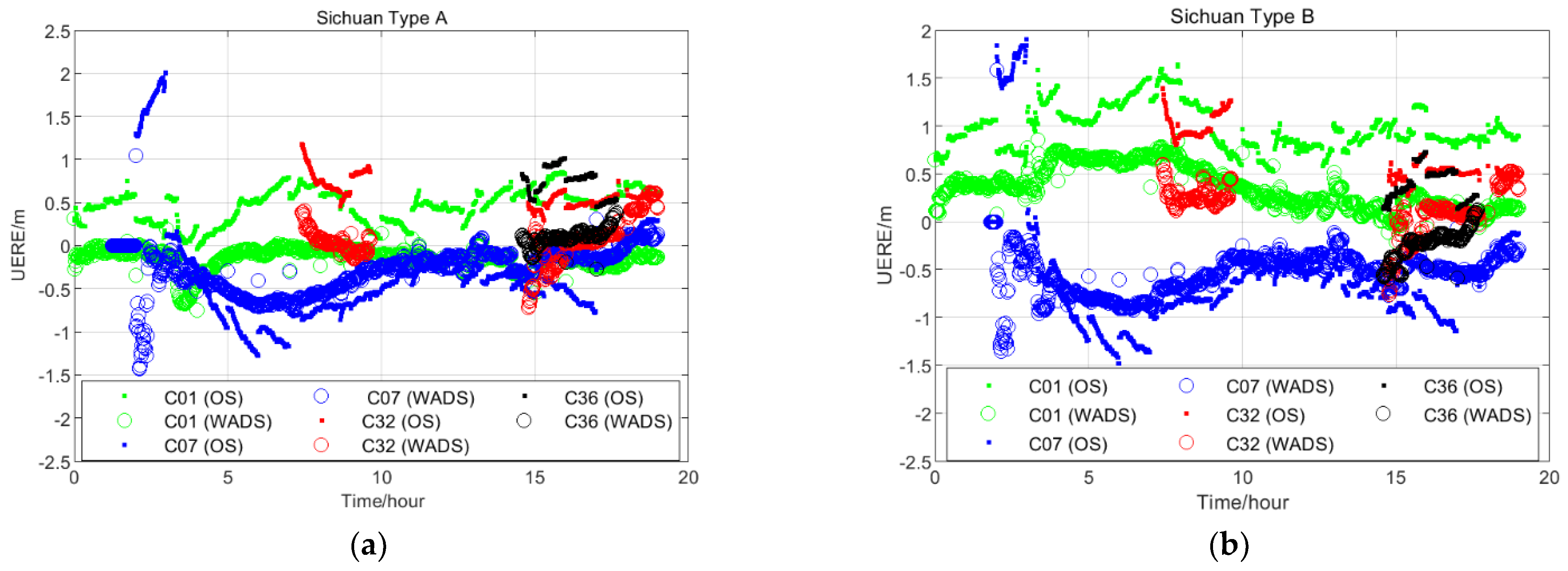
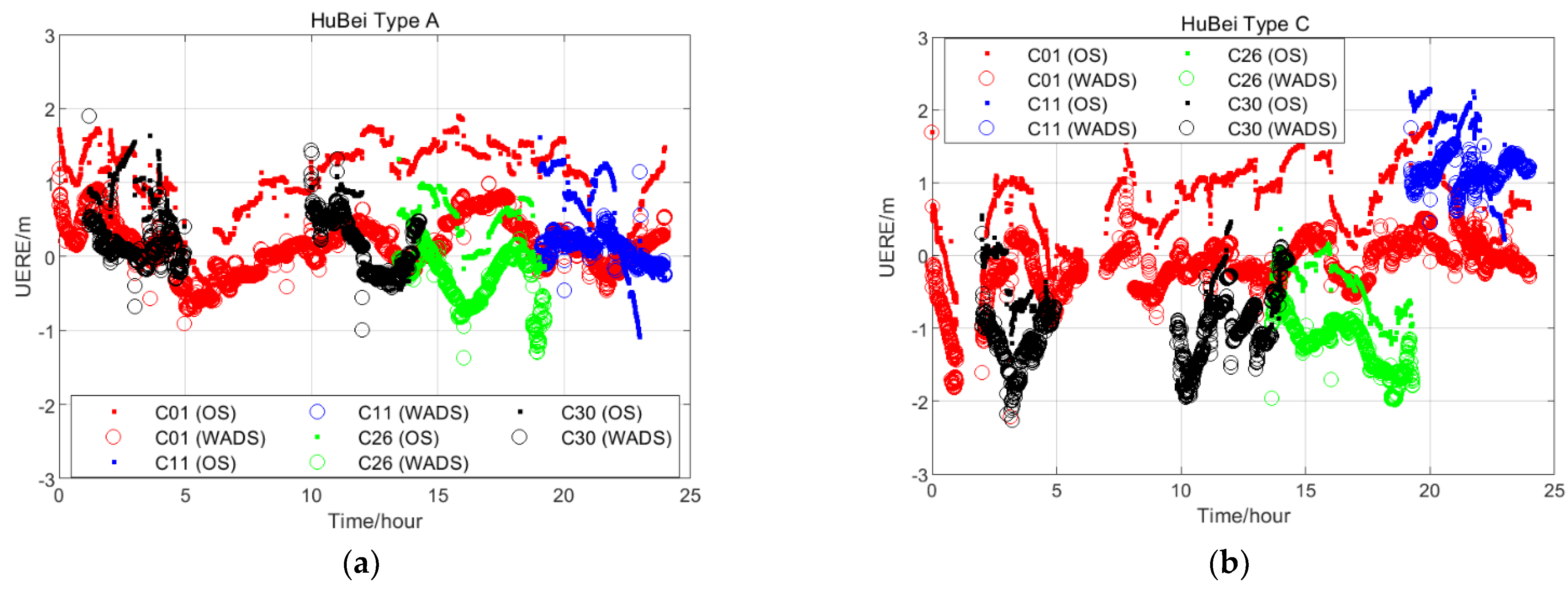
We used type A and type B receivers in the Sichuan Province and type A and type C receivers in the Hubei Province. The receivers in the same province were very close to each other. To study the impact of pseudorange bias on the WADS, observations of these receivers on 25 January 2020 were used to calculate the UERE of the BDS satellite B1I/B3I signal under the OS and the WADS. Based on the two receivers with different type, the UERE of the C1, C7, C32 and C36 satellites in the Sichuan Province are shown in Figure 4, and the UERE of the C1, C11, C26 and C30 satellites in the Hubei Province are shown in Figure 5. Figure 4a,b represent the UERE of the type A and type B receivers under the OS and the WADS in the Sichuan Province. Figure 5a,b are the UERE of the type A and type C receivers under the OS and the WADS in the Hubei Province.
In these figures, there are different constant biases in the UEREs of some satellites, as calculated by three types of receivers (type A, type B and type C) in the OS. These biases could be effectively eliminated by the equivalent clock correction parameter in the type A receiver UEREs, but they were still there and partly increased in type B and type C receiver UEREs after the correction based on the equivalent clock correction parameter. The UEREs of the type B and type C receivers for some satellites could not be improved in the WADS because of the pseudorange bias, which further affected the accuracy of the WADS for users.
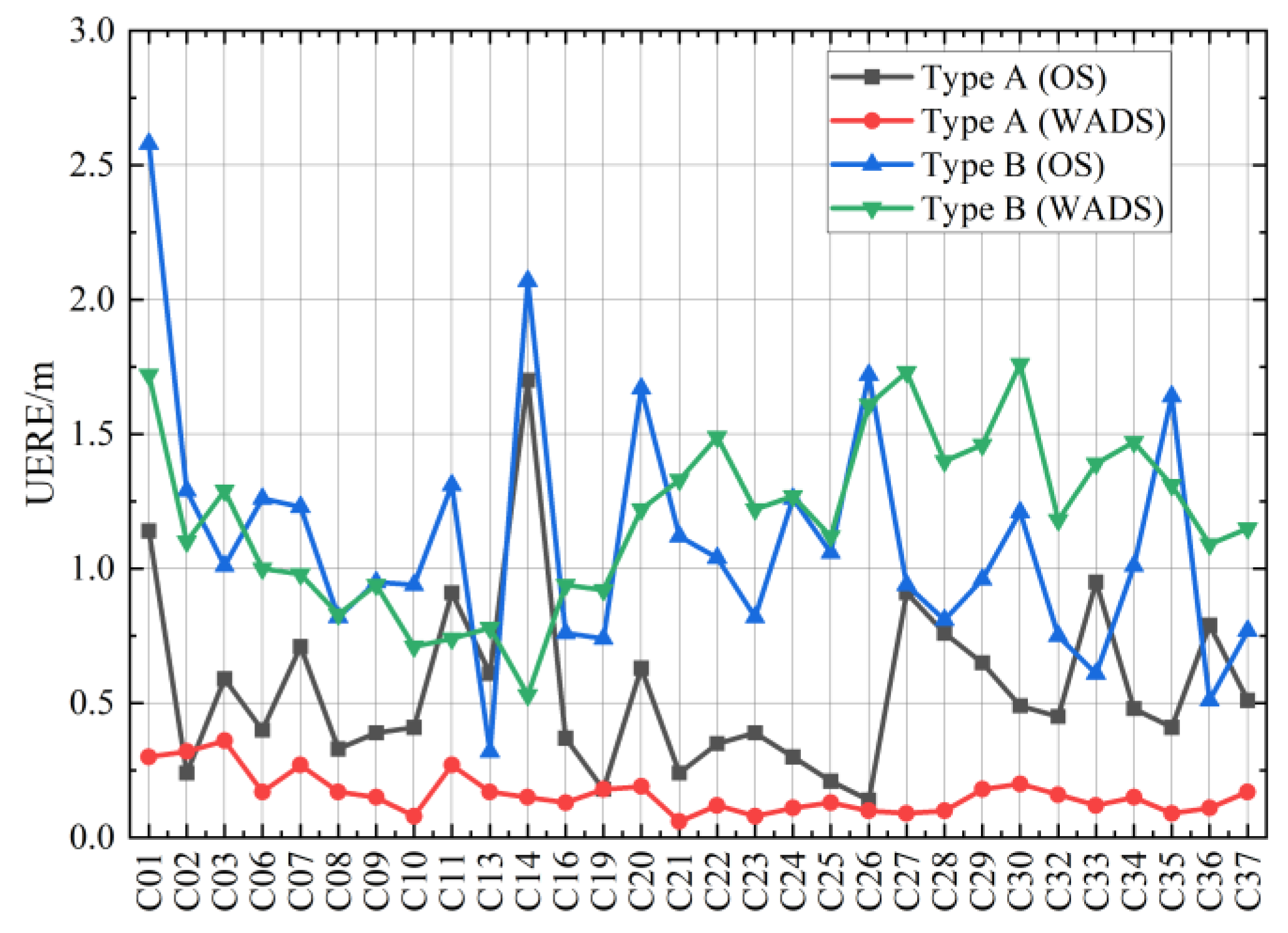
To study the influence of pseudorange bias on the UERE under the OS and the WADS, we obtained observations from type A and type B receivers in Beijing on 2 January 2020 and counted the UEREs of the BDS-3 satellites to these receivers, which are shown in Figure 6. In Figure 6, the black and red curves represent the UERE of the type A receiver under the OS and the WADS, respectively, and the blue and green curves represent the UERE of the type B receiver under the OS and the WADS, respectively. The pseudorange bias affected most of the UEREs of the type B receivers, which made the WADS unable to provide effective services to type B receivers.
To quantify the influence of the pseudorange bias on the type B receiver, we statistically determined the mean and standard deviation of the UERE for all BDS-3 satellites to type A and type B receivers according to Figure 7, which are shown in Table 4.
Table 4 shows that: (1) the average UERE of type A receivers is 0.55 m under the OS, while this average UERE is reduced by 71% under the WADS to 0.16 m; (2) the average UEREs of type B receivers are 1.11 m and 1.19 m under the OS and the WADS, respectively, and when affected by the pseudorange bias, the averages increase by 7% through the amendment of the equivalent clock parameter; (3) through the effective correction of the equivalent clock parameter, the UEREs of the type A receivers decrease to make the standard deviation of these UEREs decrease from 0.33 m to 0.07 m, however, for the standard deviation of the UEREs of the type B receivers, the number decreases from 0.47 m to 0.33 m and does not change significantly.
The WADS cannot measure the influence of pseudorange bias on different users, which means that the UDRE cannot be used by users who are influenced by pseudorange bias. The observation data and UDRE of the C04 satellite from 5 December 2019 were acquired, taking the UERE of type A and type B receivers as examples, which were compared to the UDRE, as shown in Figure 7. The blue and black lines represent the UERE of C04 to the type A and type B receivers under the WADS, respectively, and the red line is the C04 UDRE. Obviously, the UDRE cannot fully envelop the UERE of the type B receivers, which is under the WADS.

3.2. Influence on Position Accuracy

According to Equation (12), the observation equation was set and f 1 2 ( α B , B 1 I i α A , B 1 I i ) f 2 2 ( α B , B 3 I i α A , B 3 I i ) f 2 2 f 1 2 was represented as α A _ B , B 1 I B 3 I i . α B , B 1 I B 3 I i ( i = 1 , 2 , ) could not be absorbed by the receiver clock error because the same type of receiver had different pseudorange biases for different satellites, which further affected the positioning accuracy for the user.
[ δ P B , B 1 I B 3 I 1 α B , B 1 I B 3 I 1 δ P B , B 1 I B 3 I 2 α B , B 1 I B 3 I 2 δ P B , B 1 I B 3 I n α B , B 1 I B 3 I n ] = [ x B x 1 s B 1 y B y 1 s B 1 z B z 1 s B 1 1 x B x 2 s B 2 y B y 2 s B 2 z B z 2 s B 2 1 x B x n s B n y B y n s B n z B z n s B n 1 ] [ d x B d y B d z B d t B ]
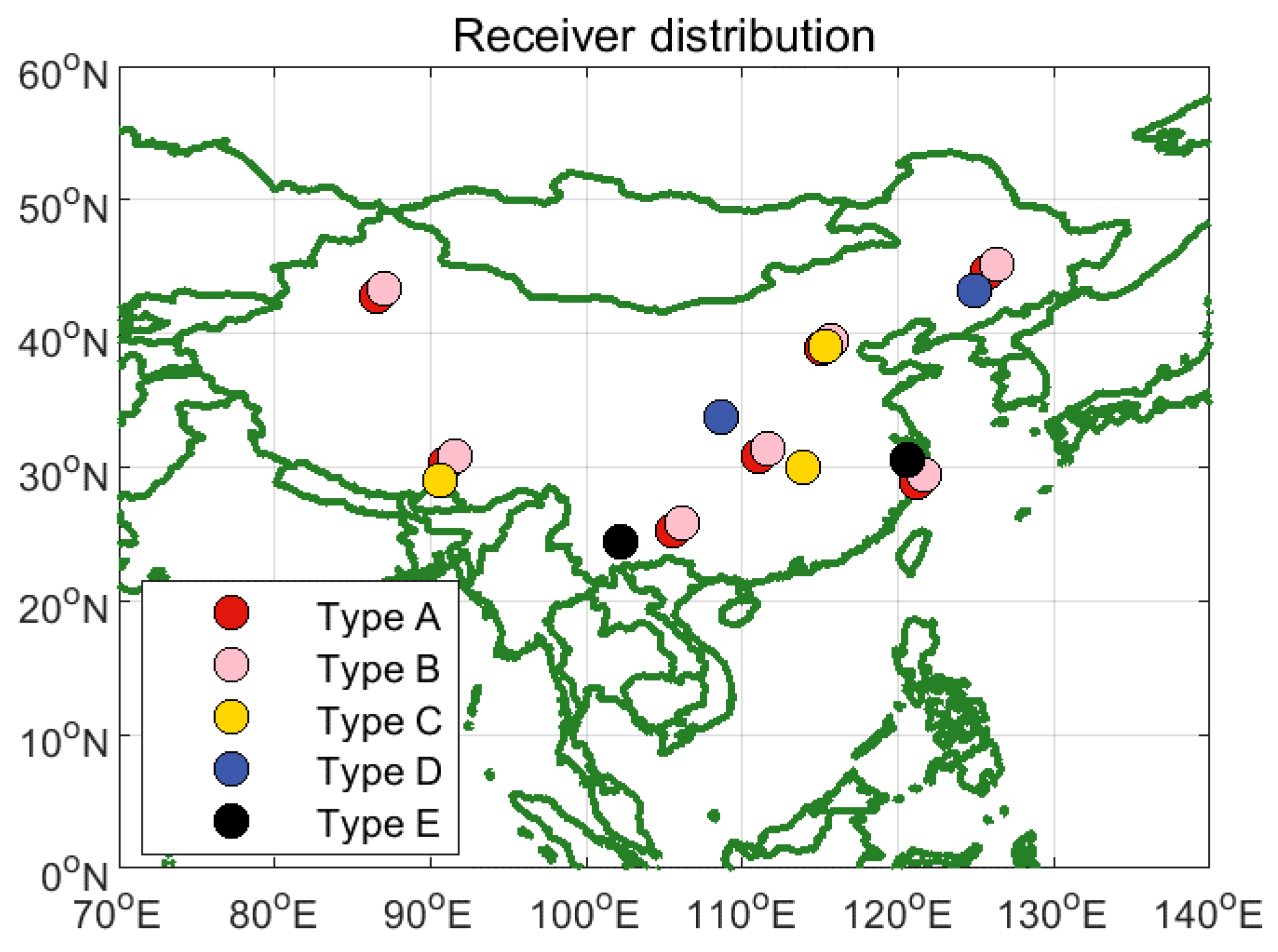
Some receivers were affected by the pseudorange bias, which prevented the UERE from being effectively reduced by the equivalent clock parameter. Moreover, the positioning accuracy was influenced by the UERE and DOP. To analyze the influence of pseudorange bias on the user positioning accuracy of the WADS, we chose 21 receivers in China, including 7 type A receivers, 7 type B receivers collocated with type A receivers, 3 type C receivers, 2 type D receivers and 2 type E receivers. The distribution of these receivers is shown in Figure 8.
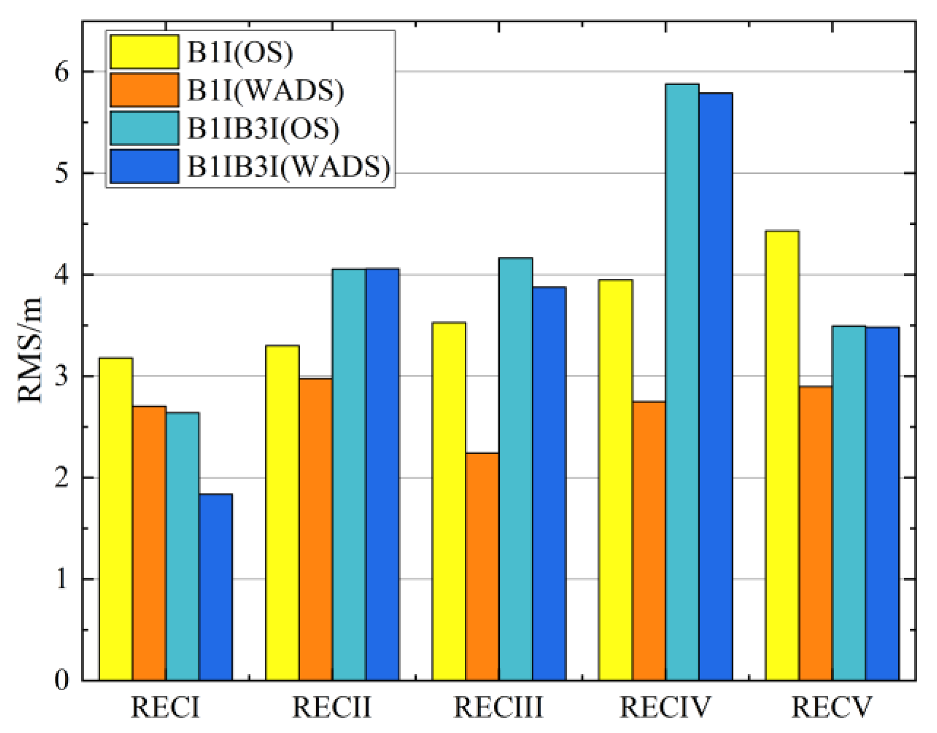
Observations of these 21 receivers taken over 14 days from 1 to 14 December 2019 were used to evaluate the positioning accuracy of the B1I and B1I/B3I frequencies in the OS and the WADS. The results are shown in Table 5, and the average B1I and B1I/B3I positioning accuracies of the five types of receivers in the two services are presented in Figure 9.
Figure 9 shows that the B1I positioning accuracies of the five types of receivers under the WADS are less than 3 m, which are significantly improved compared to those under the OS; however, for the B1I/B3I positioning accuracies, only type A receivers under the WADS are less than 3 m, which are significantly improved compared to those under the OS.
Through Figure 9 and Table 5, we show that: (1) the B1I positioning accuracies of the five types of receivers under the WADS (type A, type B, type C, type D and type E) are 2.7 m, 3.0 m, 2.2 m, 2.7 m and 2.9 m, which are improved by 15%, 10%, 37%, 30% and 35%, respectively, compared to the B1I positioning accuracies of these receivers under the OS; (2) the B1I/B3I positioning accuracies of these types of receivers under the WADS are 1.8 m, 4.0 m, 3.9 m, 5.8 m and 3.5 m, which change by 30%, 0%, 7%, 2% and 0%, respectively, compared to the B1I/B3I positioning accuracy of these receivers under the OS.
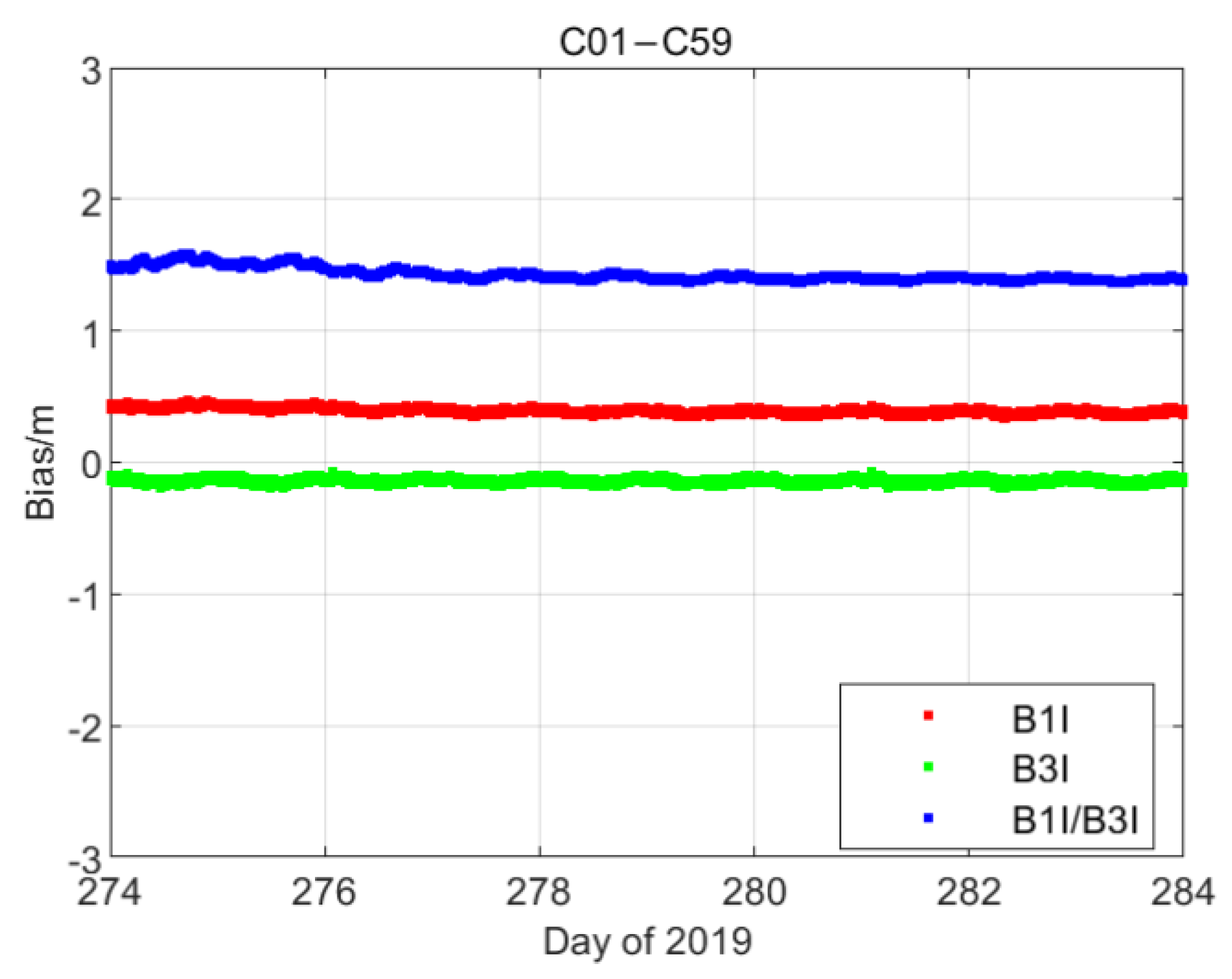
The pseudorange bias of the type B receiver at the B1I frequency is 0.14 m on average and is 1 m on average at the B1I/B3I frequency. This bias is amplified by the IF combination. The IF combination prevents the positioning accuracy from being significantly improved and becoming a non-negligible error for dual-frequency users.

3.3. Improvement after Deducting Pseudorange Bias

To improve the positioning accuracy of the receiver, which is affected by the pseudorange bias, this bias was treated as a kind of error and eliminated in the process of satellite navigation. The double-difference method was used to extract the pseudorange bias of the B1I/B3I signal. When the distance between receiver A and receiver B was close enough (such as less than 10 m), receiver A and satellite j were set as the reference receiver and satellite. Then, the following could be obtained:
d ρ ˜ i A , B 1 I B 3 I d ρ ˜ i B , B 1 I B 3 I ( d ρ ˜ j A , B 1 I B 3 I d ρ ˜ j B , B 1 I B 3 I ) = f 1 2 ( α A , B 1 I i α B , B 1 I i ) f 2 2 ( α A , B 3 I i α B , B 3 I i ) f 2 2 f 1 2 f 1 2 ( α A , B 1 I j α B , B 1 I j ) f 2 2 ( α A , B 3 I j α B , B 3 I j ) f 2 2 f 1 2 + d ε A _ B , B 1 I B 3 I i j
The relative pseudorange bias extracted by Equation (16) could be set as an error and subtracted from the UERE to eliminate a part of the common bias:
U E R E B , B 1 I B 3 I i ( d ρ ˜ i A , B 1 I B 3 I d ρ ˜ i B , B 1 I B 3 I ( d ρ ˜ j A , B 1 I B 3 I d ρ ˜ j B , B 1 I B 3 I ) ) = δ P B , B 1 I B 3 I i + f 1 2 ( α B , B 1 I j α A , B 1 I j ) f 2 2 ( α B , B 3 I j α A , B 3 I j ) f 2 2 f 1 2
The relative pseudorange bias f 1 2 ( α B , B 1 I j α A , B 1 I j ) f 2 2 ( α B , B 3 I j α A , B 3 I j ) f 2 2 f 1 2 of receiver B to satellite j relative to receiver A to satellite j was simplified as α A _ B , B 1 I B 3 I j . According to the number of observations by receiver B, the observation equation set was formed and Equation (18) could be obtained:
[ δ P B , B 1 I B 3 I 1 α A _ B , B 1 I B 3 I j δ P B , B 1 I B 3 I 2 α A _ B , B 1 I B 3 I j δ P B , B 1 I B 3 I n α A _ B , B 1 I B 3 I j ] = [ x B x 1 s B 1 y B y 1 s B 1 z B z 1 s B 1 1 x B x 2 s B 2 y B y 2 s B 2 z B z 2 s B 2 1 x B x n s B n y B y n s B n z B z n s B n 1 ] [ d x B d y B d z B d t B ]
where, ( x B , y B , z B ) are the coordinates of receiver B, ( x n , y n , z n ) are the coordinates of satellite n, s B n is the geometric distance between satellite n and receiver B, ( d x B , d y B , d z B ) is the coordinate accuracy of receiver B and d t B is the clock error of receiver B.
According to Equation (18), the least square method was used to calculate the coordinate accuracy and clock error accuracy of receiver B. To avoid the rank deficit of the equation, the number of available satellites n had to be greater than 4. Equation (18) shows that all satellites have the same constant bias from the UERE of satellite j to receiver B. This bias is eventually transferred to the receiver clock error and affects the timing accuracy of the navigation system for the user.
To verify the effectiveness of this method, type B and type C receivers were taken as examples. The positioning accuracies of these receivers under the OS and the WADS from 1 to 14 December 2019 were calculated after eliminating the pseudorange bias and the results are shown in Table 6.
Compared to Table 5, Table 6 shows the following: (1) the positioning accuracy on the B1I/B3I frequency is effectively improved by eliminating the pseudorange bias. Under the OS, the positioning accuracies of the type B and type C receivers are 3.45 m and 3.88 m and increase by 15% and 14%, respectively, compared to the original result. Under the WADS, the positioning accuracies of the type B and type C receivers are 2.87 m and 3.30 m and increase by 29% and 15%, respectively. (2) After eliminating the influence of the pseudorange bias, the positioning accuracies on the B1I/B3I frequency of the type B and type C receivers under the WADS are increased by 17% and 8%, respectively, compared to the positioning accuracy in the OS. (3) There is no apparent improvement in the positioning accuracy on the B1I frequency by eliminating the pseudorange bias. Under the OS, the positioning accuracies of the type B and type C receivers are 3.22 m and 4.06 m and increase by 2% and −15%, respectively. Under the WADS, the positioning accuracies of the type B and type C receivers are 2.70 m and 2.52 m and increase by 9% and −13%, respectively.
The pseudorange bias extracted by double-difference observations was related to the reference receiver and reference satellite. Figure 9 shows that the type C receivers were distant from the type A receivers, which meant that the result of the pseudorange bias for the type C receiver was influenced by the residual errors of the model corrections. Due to this, the improvement in the positioning accuracy on the B1I/B3I frequency of the type C receiver under the WADS is lower than that of the type B receiver. Compared to the B1I/B3I frequency, the pseudorange bias of the B1I frequency is smaller, which is obviously affected by the residual errors of the model corrections. The positioning accuracy of type C receivers is also not improved by eliminating the pseudorange bias.

4. Conclusions

We analyzed the influence of pseudorange bias on the WADS through the characteristics of this bias. To eliminate this influence, the double-difference method was used to extract the pseudorange bias and deduct it as an error in the positioning process. The conclusions are outlined below.
The pseudorange biases of the B3I signal are smaller than those of the B1I signal at the centimeter level, but the pseudorange biases of the B1I/B3I signal can reach the meter level.
The effect of the equivalent clock correction parameter on the UERE of the B1I/B3I frequency is significantly reduced by the pseudorange bias. If a receiver with the same technical status as the WADS monitoring receiver is used, the average UERE is 0.16 m under the WADS, which is reduced by 71% compared to the UERE under the OS. However, for other receivers, the average UERE calculated under the WADS is 1.19 m and 1.11 m under the OS.
The positioning accuracy for users under the WADS cannot be improved because the UERE of the users is influenced by the pseudorange bias. For the technical monitoring receiver, the B1I/B3I IF combination positioning accuracy can be improved from 2.64 m to 1.84 m, which is an increase of 30%. For other technical receivers, the B1I/B3I IF combination positioning accuracies under the WADS and the OS are 4.17 m and 4.24 m, respectively.
Integrity failure is caused by the pseudorange bias because the integrity parameter UDRE in the WADS cannot cover the UERE calculated by a receiver with a different technical status from the monitoring receiver in the WADS.
The dual-frequency positioning accuracies can be effectively improved by deducting the pseudorange bias. The dual-frequency positioning accuracy of the receiver in the OS is 3.50 m on average, comprising an 18% increase compared to the positioning accuracy before subtracting the pseudorange bias. In the WADS, the positioning accuracy is 3.03 m on average, which is a 27% increase compared to the accuracy before subtracting the pseudorange bias.
The above results indicate that the B1I/B3I frequency positioning accuracy and the integrity of receivers with different technical statuses from the monitoring receiver under the WADS are influenced by the pseudorange bias. This bias could be extracted by the double-difference method, but the accuracy of this result is still affected by the distance between the reference receivers. To obtain the declared accuracy service of the WADS, the commercial receiver state of the BDS should be referred to maintain consistency with the receiver status of the BDS monitoring station.

Author Contributions

Conceptualization, X.H. and C.T.; methodology, C.T. and Y.C.; software, Q.T. and J.Y.; validation, Y.C. and Q.T.; formal analysis, Q.T.; investigation, R.G., X.L. and Y.T.; resources, X.H.; data curation, Y.Y.; writing—original draft preparation, Q.T.; writing—review and editing, Y.C., C.T. and S.Z.; visualization, R.G., X.L. and Y.T.; supervision, Y.C. and S.Z.; project administration, X.H. and Y.C.; funding acquisition, Y.C. and S.Z. All authors have read and agreed to the published version of the manuscript.

Funding

This research was funded by the National Key Research Program of China as the “Collaborative Precision Positioning Project” grant number 2016YFB0501900; National Natural Science Foundation of China grant number 41674041 and 11203059.

Institutional Review Board Statement

Not applicable.

Data Availability Statement

The authors would like to thank the IGMAS and MGEX for the provision of BDS observations used in the study. ftp://igs.gnsswhu.cn (accessed on 30 October 2019).

Conflicts of Interest

The authors declare no conflict of interest.

References

  1. Cheolsoon, L.; Byungwoon, P.; Changdon, K.; Youngsun, Y. Benefit of SFMC SBAS and its Performance Assessment for WAAS, EGNOS, and MSAS. In Proceedings of the 33rd International Technical Meeting of the Satellite Division of The Institute of Navigation (ION GNSS+ 2020), 21–25 September 2020; pp. 1099–1131. [Google Scholar]
  2. Johnson, G.; Dhungana, G.; Delisle, J. An Evaluation of WAAS 2020+ to Meet Maritime Navigation Require-ments in Canadian Waters. In Proceedings of the 32nd International Technical Meeting of the Satellite Division of The Institute of Navigation (ION GNSS+ 2019), Miami, FL, USA, 16–20 September 2019; pp. 855–875. [Google Scholar]
  3. Bauer, F.; Greze, G.; Haddad, F.; Tourtier, A.; Rols, B.; Urbanska, K. A Study on a New EGNOS V2 Release with Enhanced System Performances. In Proceedings of the 32nd International Technical Meeting of the Satellite Division of the Institute of Navigation (ION GNSS+ 2019), Miami, FL, USA, 16–20 September 2019; pp. 902–919. [Google Scholar]
  4. Sunda, S.; Sridharan, R.; Vyas, B.M.; Khekale, P.V.; Parikh, K.P.; Ganeshan, A.S.; Sudhir, C.S.; Satish, S.V.; Bagiya, M.S. Satellite-based augmentation systems: A novel and cost-effective tool for ionospheric and space weather studies. Space Weather Int. J. Res. Appl. 2015, 13, 6–15. [Google Scholar] [CrossRef]
  5. Luciano, T.; Andrea, D.C.C.W.; Pozzobon, O.; Serrano, G.F.; Calabrese, A.; Perring, A.; Mabilleau, M.; Vecchione, G. Broadcast Data Authentication Concepts for Future SBAS Ser-vices. In Proceedings of the 33rd International Technical Meeting of the Satellite Division of The Institute of Navigation (ION GNSS+ 2020), 25–28 January 2020; pp. 1–26. [Google Scholar]
  6. Cheolsoon, L.; Donghyun, S.; Hwang, H.-Y.; Park, B.; Kim, E.; Kee, C.; Seo, S.; Park, J. Performance Analysis on Multi-Constellation SBAS of the Modified L1-only SBAS Message. In Proceedings of the 30th International Technical Meeting of the Satellite Division of The Institute of Navigation (ION GNSS+ 2017), Portland, OR, USA, 25–29 September 2017; pp. 1089–1094. [Google Scholar]
  7. Grewal, M.S. Space-based augmentation for global navigation satellite systems. IEEE Trans. Ultrason. Ferroelectr. Freq. Control. 2012, 59, 497–503. [Google Scholar] [CrossRef] [PubMed]
  8. Felski, A.; Nowak, A. On Egnos Monitoring in Local Conditions. Artif. Satell. 2013, 48, 85–92. [Google Scholar] [CrossRef] [Green Version]
  9. Felski, A.; Nowak, A.; Woźniak, T. Accuracy and Availability of Egnos-Results of Observations" Artificial Satellites. Artif. Satell. 2011, 46, 111–118. [Google Scholar] [CrossRef] [Green Version]
  10. Nandulal, S.; Rao, C.B.; Indi, C.L.; Irulappan, M.; Arulmozhi, S.; Soma, P. Evaluation of real-time position accuracy and LNAV/VNAV service availability of GAGAN SBAS (Wide Area Differential GPS) over Indian region. In Proceedings of the 2008 Tyrrhenian International Workshop on Digital Communications—Enhanced Surveillance of Aircraft and Vehicles, Capri, Italy, 3–5 September 2008; pp. 1–6. [Google Scholar] [CrossRef]
  11. CSNO. BeiDou Navigation Satellite System Signal B3I (Version 3.0) [EB/OL]. 2019. Available online: http://www.beidou.gov.cn.2020.02 (accessed on 30 December 2020).
  12. Liu, J.-L.; Cao, Y.-L.; Hu, X.-G.; Tang, C.-P. Beidou wide-area augmentation system clock error correction and performance verification. Adv. Space Res. 2020, 65, 2348–2359. [Google Scholar] [CrossRef]
  13. Teunissen, P.J.G.; Montenbruck, O. Springer Handbook of Global Navigation Satellite Systems; Springer: Cham, Switzerland, 2017. [Google Scholar]
  14. Montenbruck, O.; Steigenberger, P.; Hauschild, A. Broadcast versus precise ephemerides: A multi-GNSS perspective. GPS Solut. 2014, 19, 321–333. [Google Scholar] [CrossRef]
  15. Steigenberger, P.; Montenbruck, O. Galileo status: Orbits, clocks, and positioning. GPS Solut. 2017, 21, 319–331. [Google Scholar] [CrossRef]
  16. Chen, J.; Hu, X.; Tang, C.; Zhou, S.; Yang, Y.; Pan, J.; Ren, H.; Ma, Y.; Tian, Q.; Wu, B.; et al. SIS accuracy and service performance of the BDS-3 basic system. Sci. China Phys. Mech. Astron. 2020, 63, 269511. [Google Scholar] [CrossRef]
  17. Enge, P.; Walter, T.; Pullen, S.; Kee, C.; Chao, Y.C.; Tsai, Y.J. Wide area augmentation of the Global Positioning System. Proc. IEEE 1996, 84, 1063–1088. [Google Scholar] [CrossRef]
  18. Phelts, R.E.; Akos, D.M.; Enge, P. Robust Signal Quality Monitoring and Detection of Evil Waveforms. In Proceedings of the International Technical Meeting of the Satellite Division of the Institute of Navigation, Salt Lake City, UT, USA, 19–22 September 2000; pp. 1180–1190. [Google Scholar]
  19. Wong, G.; Chen, Y.H.; Phelts, R.E.; Walter, T.; Enge, P. Measuring code-phase differences due to inter-satellite hardware differences. In Proceedings of the 25th international technical meeting of the satellite division of the institute of navigation (ION GNSS 2012), ION GNSS, Nashville, TN, USA, 17–21 September 2012; pp. 2150–2158. [Google Scholar]
  20. Wong, G.; Phelts, R.E.; Walter, T.; Enge, P. Characterization of Signal Deformations for GPS and WAAS Satellites. In Proceedings of the International Technical Meeting of the Satellite Division of the Institute of Navigation, Portlands, OR, USA, 21–24 September 2010; pp. 3143–3151. [Google Scholar]
  21. Wong, G.; Phelts, R.; Eric, W.T.; Enge, P. Bounding Errors Caused by Nominal GNSS Signal Deformations. In Proceedings of the 24th International Technical Meeting of the Satellite Division of The Institute of Navigation (ION GNSS 2011), Portland, OR, USA, 21–24 September 2011; pp. 2657–2664. [Google Scholar]
  22. Hauschild, A.; Montenbruck, O. The Effect of Correlator and Front-End Design on GNSS Pseudorange Biases for Geodetic Receivers. Navigation 2016, 63, 443–453. [Google Scholar] [CrossRef]
  23. Hauschild, A.; Montenbruck, O. A study on the dependency of GNSS pseudorange biases on correlator spacing. GPS Solut. 2014, 20, 159–171. [Google Scholar] [CrossRef]
  24. Chen, L.; Li, M.; Zhao, Y.; Zheng, F.; Shi, C. Clustering Code Biases between BDS-2 and BDS-3 Satellites and Effects on Joint Solution. Remote Sens. 2021, 13, 15. [Google Scholar] [CrossRef]
  25. Tang, C.; Su, C.; Hu, X.; Gao, W.; Liu, L.; Lu, J.; Chen, Y.; Liu, C.; Wang, W.; Zhou, S. Characterization of pesudorange bias and its effect on positioning for BDS satellites. Acta Geodaet. Cartograph. Sin. 2020, 49, 1131–1138. [Google Scholar]
  26. Li, R.; Li, Z.; Wang, N.; Tang, C.; Ma, H.; Zhang, Y.; Wang, Z.; Wu, J. Considering inter-receiver pseudorange biases for BDS-2 precise orbit determination. Measurement 2021, 177, 109251. [Google Scholar] [CrossRef]
  27. Sun, G.; Shen, L.; Zhu, X.; Jia, X.; Liu, X.; Guo, M.; Zhai, W.; Hong, Y.; Zheng, J. Accuracy Analysis of GNSS Broadcast Ionospheric Model. In Proceedings of the China Satellite Navigation Conference (CSNC), CSNC 2019, Beijing, China, 22–25 May 2019; Sun, J., Yang, C., Yang, Y., Eds.; Springer: Cham, Switzerland; Volume 563. [Google Scholar]
Figure 1. The pseudorange bias extraction result from the C01 satellite, as obtained by the type B receiver.
Remotesensing 14 00432 g001
Figure 2. The pseudorange bias extraction result from the C39 satellite, as obtained by the type B receiver.
Remotesensing 14 00432 g002
Figure 3. The pseudorange bias of the type B receivers to the Beidou satellite in the B1I, B3I and B1I/B3I signals.
Remotesensing 14 00432 g003
Figure 4. The UEREs calculated by a type A receiver and a type B receiver in the OS and the WADS: (a) the results of the type A receiver; (b) the results of the type B receiver.
Remotesensing 14 00432 g004
Figure 5. The UEREs calculated by a type A receiver and a type C receiver in the OS and the WADS: (a) the results of the type A receiver; (b) the results of the type C receiver.
Remotesensing 14 00432 g005
Figure 6. The UEREs of BDS satellites, as calculated by type A and type B receivers under the OS and the WADS.
Remotesensing 14 00432 g006
Figure 7. The UEREs and UDREs of the C04 satellite, as calculated by the type A and B receivers for the B1I/B3I IF combination in the WADS.
Remotesensing 14 00432 g007
Figure 8. Receiver distribution.
Remotesensing 14 00432 g008
Figure 9. The positioning accuracy in the B1I and the B1I/B3I IF combination of the five types of receivers in the OS and the WADS.
Remotesensing 14 00432 g009
Table 1. BDS WADS (D2) messages on B1I/B3I frequency.
Information from BDS WADSUpdate PeriodParameter Range
Equivalent Clock Correction (Δt)18 s−4096~4096
User Differential Range Error Index (UDREI)3 s0~15
Vertical Delay at Ionospheric Grid Points ()180 s0~63.625 m (the coverage area is 70–145 degrees East longitude and 7.5–55 degrees North latitude, divided according to 5 × 2.5 degrees)
Grid Ionospheric Vertical Error Index (GIVEI)180 s0~15
Table 2. BDS satellite types (July 2020).
BDS-2BDS-3
PRNSystem TypeSatellite TypePRNSystem TypeSatellite TypePRNSystem TypeSatellite Type
C01BDS-2GEOC19BDS-3MEOC36BDS-3MEO
C02BDS-2GEOC20BDS-3MEOC37BDS-3MEO
C03BDS-2GEOC21BDS-3MEOC38BDS-3IGSO
C04BDS-2GEOC22BDS-3MEOC39BDS-3IGSO
C05BDS-2GEOC23BDS-3MEOC40BDS-3IGSO
C06BDS-2IGSOC24BDS-3MEOC41BDS-3MEO
C07BDS-2IGSOC25BDS-3MEOC42BDS-3MEO
C08BDS-2IGSOC26BDS-3MEOC43BDS-3MEO
C09BDS-2IGSOC27BDS-3MEOC44BDS-3MEO
C10BDS-2IGSOC28BDS-3MEOC45BDS-3MEO
C11BDS-2MEOC29BDS-3MEOC46BDS-3MEO
C12BDS-2MEOC30BDS-3MEOC59BDS-3GEO
C13BDS-2IGSOC32BDS-3MEOC60BDS-3GEO
C14BDS-2MEOC33BDS-3MEOC61BDS-3GEO
C16BDS-2IGSOC34BDS-3MEO
C18BDS-2GEOC35BDS-3MEO
Table 3. Information about the five receiver types.
Receiver TypeInformation
AWADS monitoring receiver
BCETC-20-1
CCETC-54
DCETC-20-2
EUNICORE
Table 4. The results of the BDS satellite UEREs, as calculated by type A and type B receivers under the OS and the WADS (unit: meter).
Receiver TypeUERE (OS)UERE (WADS)
MeanStdMeanStd
Type A0.550.330.160.07
Type B1.110.471.190.32
Table 5. The single- and dual-frequency positioning accuracy in the BDS OS and the WADS (unit: meter).
StationB1IB1I/B3I
OSWADSOSWADS
HorizontalVerticalHorizontalVerticalHorizontalVerticalHorizontalVertical
Type A 11.472.80.832.061.542.110.791.23
Type A 21.542.970.81.770.942.160.51.97
Type A 30.882.691.072.281.142.070.851.56
Type A 41.842.641.382.181.482.921.142.07
Type A 51.472.311.242.911.652.641.241.97
Type A 61.133.140.982.521.092.450.651.49
Type A 70.963.070.812.91.182.140.641.27
Type B 11.632.891.092.051.962.841.82.84
Type B 21.622.960.922.141.32.941.213.48
Type B 31.032.81.142.621.543.191.373.32
Type B 41.933.471.793.553.27.033.067.28
Type B 51.752.341.52.761.994.881.944.33
Type B 61.283.261.062.891.533.411.53.4
Type B 70.962.70.712.541.332.320.952.35
Type C 11.292.91.231.482.763.182.622.89
Type C 21.073.881.522.572.433.272.42.57
Type C 31.13.21.251.322.353.492.23.59
Type D 11.663.481.652.312.864.972.694.44
Type D 21.23.861.582.142.395.532.545.86
Type E 11.825.31.622.612.082.41.862.48
Type E 21.243.011.22.442.72.692.582.88
Mean (type A)1.332.801.022.371.292.360.831.65
Mean (type B)1.462.921.172.651.843.801.693.86
Mean (type C)1.153.331.331.792.513.312.413.02
Mean (type D)1.433.671.622.232.635.252.625.15
Mean (type E)1.534.161.412.532.392.552.222.68
Table 6. The B1I and B1I/B3I positioning accuracy in the OS and the WADS after correcting the pseudorange bias of the type B and type C receivers to the BDS satellites (unit: meter).
StationB1IB1I/B3I
OSWADSOSWADS
HorizontalVerticalHorizontalVerticalHorizontalVerticalHorizontalVertical
Type B 11.073.010.612.471.341.950.841.17
Type B 22.472.702.202.770.692.310.522.54
Type B 30.782.710.692.291.282.841.022.55
Type B 41.383.001.302.521.933.991.613.44
Type B 61.373.680.932.531.572.791.182.17
Type B 71.082.441.082.111.854.871.593.98
Type C 11.263.631.281.941.693.321.392.95
Type C 21.244.621.432.921.332.901.532.35
Type C 31.243.371.321.551.683.421.453.58
Mean (type B)1.362.921.142.451.443.131.132.64
Mean (type C)1.253.871.342.141.573.221.462.96
Publisher’s Note: MDPI stays neutral with regard to jurisdictional claims in published maps and institutional affiliations.

