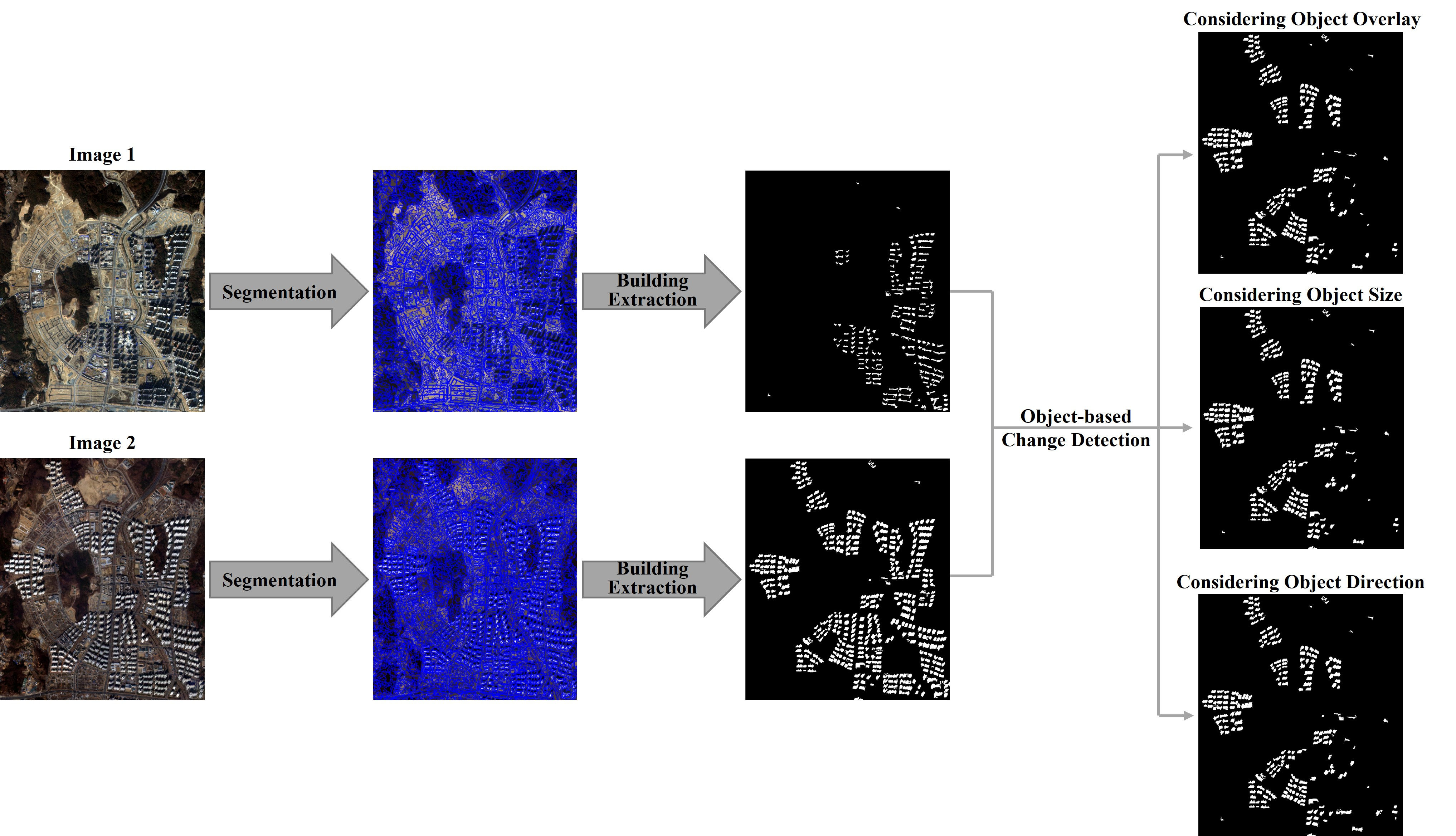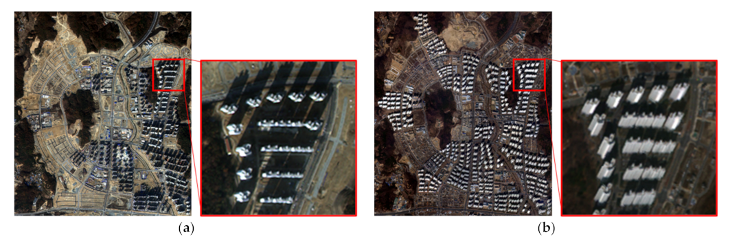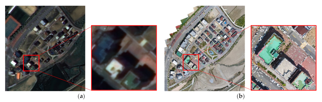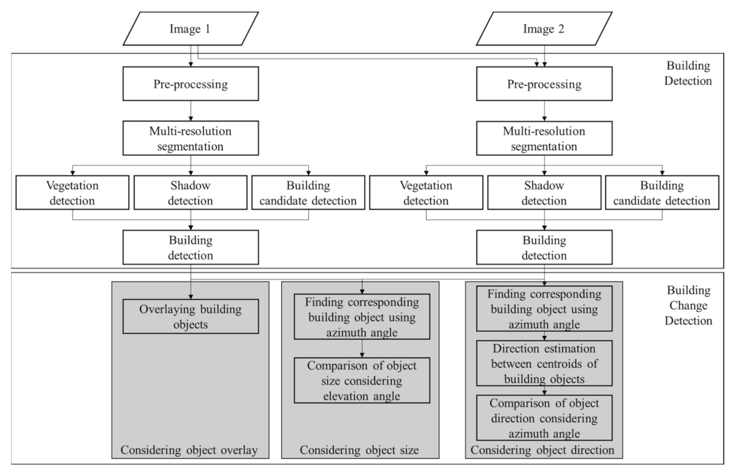
Change Detection of Building Objects in High-Resolution Single-Sensor and Multi-Sensor Imagery Considering the Sun and Sensor’s Elevation and Azimuth Angles


Abstract
1. Introduction
2. Study Site and Evaluation Criteria
2.1. Study Site
2.2. Evaluation Creteria
3. Methods
3.1. Preprocessing
3.2. Multiresolution Segmentation
3.3. Object-Based Building Detection
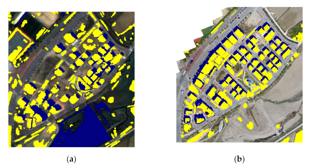
3.3.1. Vegetation and Shadow Detection
3.3.2. Building Candidate Detection
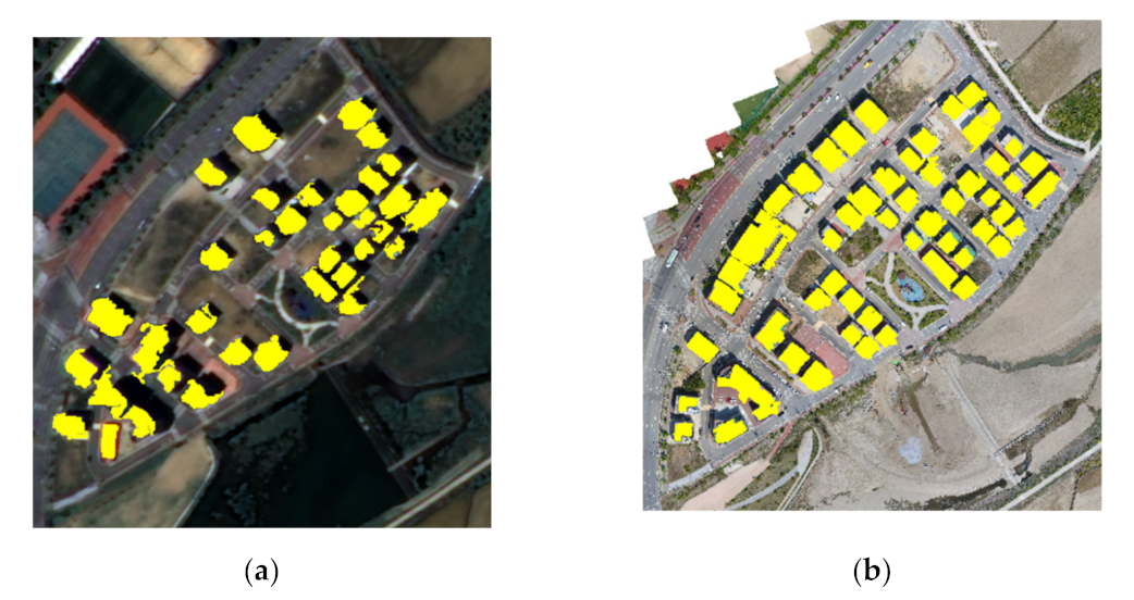
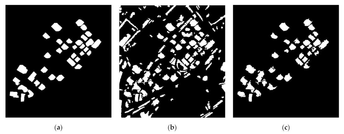
3.3.3. Final Building Detection Using Shadow Information
3.4. Object-Based Building Change Detection
4. Experimental Results
4.1. Building Detection Results
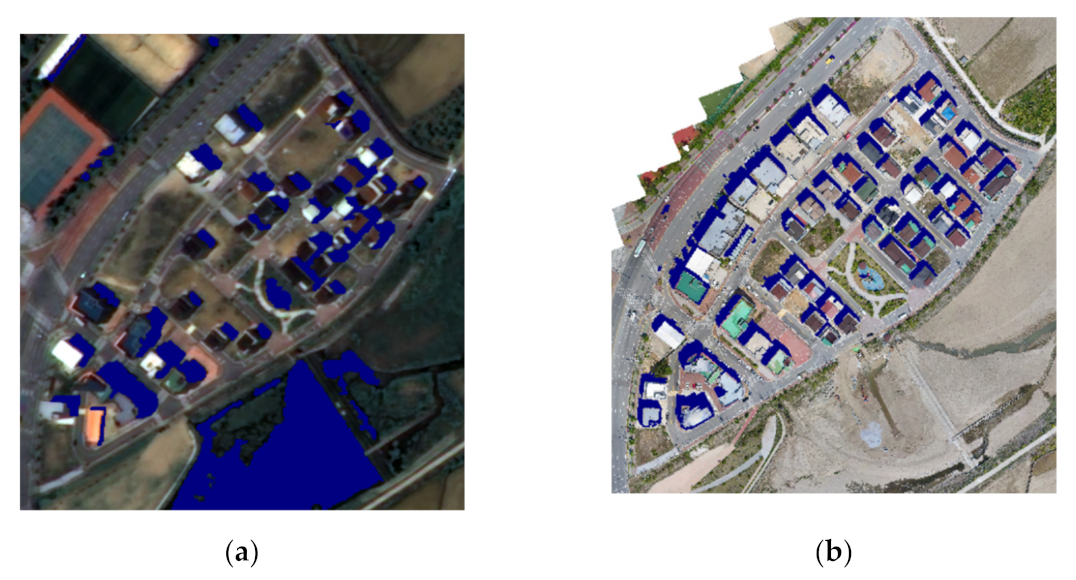
4.1.1. Site 1: Single-Sensor Imagery
4.1.2. Site 2: Multi-Sensor Imagery
4.2. Object-Based Building Change Detection Results
4.2.1. Site 1: Single-Sensor Imagery
4.2.2. Site 2: Multi-Sensor Imagery
5. Discussion
5.1. Site 1: Single-Sensor Imagery
5.2. Site 2: Multi-Sensor Imagery
6. Conclusions
Author Contributions
Funding
Conflicts of Interest
References
- Huang, X.; Zhang, L. A multidirectional and multiscale morphological index for automatic building extraction from multispectralgeoeye-1 imagery. Photogramm. Eng. Remote Sens. 2011, 77, 721–732. [Google Scholar] [CrossRef] [Scilit]
- Attarzadeh, R.; Momeni, M. Object-based rule sets and its transferability for building extraction from high resolution satellite imagery. J. Indian Soc. Remote Sens. 2018, 46, 169–178. [Google Scholar] [CrossRef] [Scilit]
- Du, S.; Zhang, Y.; Zou, Z.; Xu, S.; He, X.; Chen, S. Automatic building extraction from LiDAR data fusion of point and grid-based features. ISPRS J. Photogramm. Remote Sens. 2017, 130, 294–307. [Google Scholar] [CrossRef] [Scilit]
- Park, H.; Choi, J.; Park, W.; Park, H. Modified S 2 CVA algorithm using cross-sharpened images for unsupervised change detection. Remote Sens. 2018, 10, 3301. [Google Scholar] [CrossRef] [Scilit]
- Pang, S.; Hu, X.; Wang, Z.; Lu, Y.; Balzter, H.; Blaschke, T.; Thenkabail, P.S. Object-based analysis of airborne LiDAR data for building change detection. Remote Sens. 2014, 6, 10733–10749. [Google Scholar] [CrossRef] [Scilit]
- Meng, X.; Currit, N.; Wang, L. Morphology-based building detection from airborne lidar data. In Proceedings of the American Society for Photogrammetry and Remote Sensing-ASPRS Annual Conference, Portland, OR, USA, 28 April–2 May 2008; Volume 2, pp. 484–492. [Google Scholar]
- Yan, Y.; Tan, Z.; Su, N.; Zhao, C. Building extraction based on an optimized stacked sparse autoencoder of structure and training samples using LIDAR DSM and optical images. Sensors 2017, 17, 1957. [Google Scholar] [CrossRef] [Scilit]
- Saha, S.; Bovolo, F.; Bruzzone, L. Building change detection in VHR SAR images via unsupervised deep transcoding. IEEE Trans. Geosci. Remote Sens. 2021, 59, 1917–1929. [Google Scholar] [CrossRef] [Scilit]
- Zhao, L.; Zhou, X.; Kuang, G. Building detection from urban SAR image using building characteristics and contextual information. EURASIP J. Adv. Signal Process. 2013, 2013, 1–16. [Google Scholar] [CrossRef] [Scilit]
- Zha, Y.; Gao, J.; Ni, S. Use of normalized difference built-up index in automatically mapping urban areas from TM imagery. Int. J. Remote Sens. 2003, 24, 583–594. [Google Scholar] [CrossRef] [Scilit]
- Xu, H. A new index for delineating built-up land features in satellite imagery. Int. J. Remote Sens. 2008, 29, 4269–4276. [Google Scholar] [CrossRef] [Scilit]
- As-syakur, A.R.; Adnyana, I.W.S.; Arthana, I.W.; Nuarsa, I.W. Enhanced built-UP and bareness index (EBBI) for mapping built-UP and bare land in an urban area. Remote Sens. 2012, 4, 2957–2970. [Google Scholar] [CrossRef] [Scilit]
- Sirmaçek, B.; Ünsalan, C. Building detection from aerial images using invariant color features and shadow information. In Proceedings of the 2008 23rd International Symposium on Computer and Information Sciences, Istanbul, Turkey, 27–29 October 2008; pp. 1–5. [Google Scholar] [CrossRef] [Scilit]
- Liu, H.; Yang, M.; Chen, J.; Hou, J.; Deng, M. Line-constrained shape feature for building change detection in VHR remote sensing imagery. ISPRS Int. J. Geo-Inf. 2018, 7, 410. [Google Scholar] [CrossRef] [Scilit]
- Li, J.; Cao, J.; Feyissa, M.E.; Yang, X. Automatic building detection from very high-resolution images using multiscale morphological attribute profiles. Remote Sens. Lett. 2020, 11, 640–649. [Google Scholar] [CrossRef] [Scilit]
- Huang, X.; Zhang, L.; Zhu, T. Building change detection from multitemporal high-resolution remotely sensed images based on a morphological building index. IEEE J. Sel. Top. Appl. Earth Obs. Remote Sens. 2013, 7, 105–115. [Google Scholar] [CrossRef] [Scilit]
- Huang, X.; Zhu, T.; Zhang, L.; Tang, Y. A novel building change index for automatic building change detection from high-resolution remote sensing imagery. Remote Sens. Lett. 2014, 5, 713–722. [Google Scholar] [CrossRef] [Scilit]
- Sheikh, M.A.A.; Kole, A.; Maity, T. A multi-level approach for change detection of buildings using satellite imagery. Int. J. Artif. Intell. Tools 2018, 27, 1850031. [Google Scholar] [CrossRef] [Scilit]
- Javed, A.; Jung, S.; Lee, W.H.; Han, Y. Object-based building change detection by fusing pixel-level change detection results generated from morphological building index. Remote Sens. 2020, 12, 2952. [Google Scholar] [CrossRef] [Scilit]
- Gong, J.; Hu, X.; Pang, S.; Li, K. Patch matching and dense crf-based co-refinement for building change detection from bi-temporal aerial images. Sensors 2019, 19, 1557. [Google Scholar] [CrossRef] [Scilit]
- Wang, B.; Choi, J.; Choi, S.; Lee, S.; Wu, P.; Gao, Y. Image fusion-based land cover change detection using multi-temporal high-resolution satellite images. Remote Sens. 2017, 9, 804. [Google Scholar] [CrossRef] [Scilit]
- Keyport, R.N.; Oommen, T.; Martha, T.R.; Sajinkumar, K.S.; Gierke, J.S. A comparative analysis of pixel-and object-based detection of landslides from very high-resolution images. Int. J. Appl. Earth Obs. Geoinf. 2018, 64, 1–11. [Google Scholar] [CrossRef] [Scilit]
- Tang, Y.; Zhang, L.; Huang, X. Object-oriented change detection based on the Kolmogorov–Smirnov test using high-resolution multispectral imagery. Int. J. Remote Sens. 2011, 32, 5719–5740. [Google Scholar] [CrossRef] [Scilit]
- Ma, L.; Li, M.; Blaschke, T.; Ma, X.; Tiede, D.; Cheng, L.; Chen, Z.; Chen, D. Object-based change detection in urban areas: The effects of segmentation strategy, scale, and feature space on unsupervised methods. Remote Sens. 2016, 8, 761. [Google Scholar] [CrossRef] [Scilit]
- Im, J.; Jensen, J.R.; Tullis, J.A. Object-based change detection using correlation image analysis and image segmentation. Int. J. Remote Sens. 2008, 29, 399–423. [Google Scholar] [CrossRef] [Scilit]
- Leichtle, T.; Geiß, C.; Wurm, M.; Lakes, T.; Taubenböck, H. Unsupervised change detection in VHR remote sensing imagery–an object-based clustering approach in a dynamic urban environment. Int. J. Appl. Earth Obs. Geoinf. 2017, 54, 15–27. [Google Scholar] [CrossRef] [Scilit]
- Zhang, X.; Xiao, P.; Feng, X.; Yuan, M. Separate segmentation of multi-temporal high-resolution remote sensing images for object-based change detection in urban area. Remote Sens. Environ. 2017, 201, 243–255. [Google Scholar] [CrossRef] [Scilit]
- Peng, J.; Liu, Y.C. Model and context-driven building extraction in dense urban aerial images. Int. J. Remote Sens. 2005, 26, 1289–1307. [Google Scholar] [CrossRef] [Scilit]
- Katartzis, A.; Sahli, H. A stochastic framework for the identification of building rooftops using a single remote sensing image. IEEE Trans. Geosci. Remote Sens. 2008, 46, 259–271. [Google Scholar] [CrossRef]
- Izadi, M.; Saeedi, P. Three-dimensional polygonal building model estimation from single satellite images. IEEE Trans. Geosci. Remote Sens. 2012, 50, 2254–2272. [Google Scholar] [CrossRef] [Scilit]
- Ok, A.O. Automated detection of buildings from single VHR multispectral images using shadow information and graph cuts. ISPRS J. Photogramm. Remote Sens. 2013, 86, 21–40. [Google Scholar] [CrossRef] [Scilit]
- Gao, X.; Wang, M.; Yang, Y.; Li, G. Building extraction from RGB VHR images using shifted shadow algorithm. IEEE Access 2018, 6, 22034–22045. [Google Scholar] [CrossRef] [Scilit]
- Liasis, G.; Stavrou, S. Satellite images analysis for shadow detection and building height estimation. ISPRS J. Photogramm. Remote Sens. 2016, 119, 437–450. [Google Scholar] [CrossRef] [Scilit]
- Zhou, G.; Sha, H. Building shadow detection on ghost images. Remote Sens. 2020, 12, 679. [Google Scholar] [CrossRef] [Scilit]
- Hu, L.; Zheng, J.; Gao, F. A building extraction method using shadow in high resolution multispectral images. Int. Geosci. Remote Sens. Symp. 2011, 1862–1865. [Google Scholar] [CrossRef] [Scilit]
- Jung, S.J.; Kim, T.H.; Lee, W.H.; Han, Y.K. Object-based change detection using various pixel-based change detection results and registration noise. J. Korean Soc. Surv. Geod. Photogramm. Cartogr. 2019, 37, 481–489. [Google Scholar] [CrossRef]
- Jung, S.; Park, J.; Lee, W.H.; Han, Y. Object-based building change detection using azimuth and elevation angles of sun and platform in the multi-sensor images. Korean J. Remote Sens. 2020, 36, 989–1006. [Google Scholar] [CrossRef]
- Benarchid, O.; Raissouni, N. Building extraction using object-based classification and shadow information in very high resolution multispectral images, a case study: Tetuan, Morocco. Can. J. Image Process. Comput. Vis. 2013, 4, 1–8. [Google Scholar]
- Cooner, A.J.; Shao, Y.; Campbell, J.B. Detection of urban damage using remote sensing and machine learning algorithms: Revisiting the 2010 Haiti earthquake. Remote Sens. 2016, 8, 868. [Google Scholar] [CrossRef] [Scilit]
- Haralick, R.M.; Dinstein, I.; Shanmugam, K. Textural features for image classification. IEEE Trans. Syst. Man Cybern. 1973, SMC-3, 610–621. [Google Scholar] [CrossRef] [Scilit]
- Sheen, D. A generalized Green’s theorem. Appl. Math. Lett. 1992, 5, 95–98. [Google Scholar] [CrossRef] [Scilit]
- Suliman, A.; Zhang, Y. Development of line-of-sight digital surface model for co-registering off-nadir VHR satellite imagery with elevation data. IEEE J. Sel. Top. Appl. Earth Obs. Remote Sens. 2015, 8, 1913–1923. [Google Scholar] [CrossRef] [Scilit]



| Sensor | KOMPSAT-3 |
|---|---|
| Spatial resolution | Pan: 0.7 m MS: 2.8 m |
| Spectral bands | >Pan: 450–900 nm Blue: 450–520 nm Green: 520–600 nm Red: 630–690 nm NIR: 760–900 nm |
| >Swath width | >≥15 km (at nadir) |
| Radiometric resolution | 14 bits |
| UAV: Inspire 2 | Camera: Zenmuse X4S | ||
|---|---|---|---|
 |  | ||
| Weight | 3400 g | Weight | 253 g |
| Speed | Max: 94 km/h | FOV | 84° |
| Flight altitude | ≤5000 m | Focal length | 8.8 mm |
| Flight time | ≤27 min | Image size | 4864 × 3648 pixels |
| Hovering accuracy | Vertical: 0.5 m Horizontal: 1.5 m | IOS | 100 |
| Sensor | KOMPSAT-3 | ||
|---|---|---|---|
| Acquisition date | 16 November 2013 | 26 February 2019 | |
| Resolution | 2.8 m (MS) | ||
| Image size | 936 × 1076 pixels | ||
| Location | Sejong-si, South Korea | ||
| Sensor angle | Azimuth | 261.369° | 207.623° |
| Elevation | 79.760° | 62.328° | |
| Incidence | 10.240° | 27.672° | |
| Sun angle | Azimuth | 204.811° | 198.504° |
| Elevation | 33.608° | 47.451° | |
| Sensor | KOMPSAT-3 | UAV | |
|---|---|---|---|
| Acquisition date | 18 May 2016 | 28 April 2020 | |
| Resolution | 0.7 m (pan-sharpened) | 0.7 m | |
| Image size | 437 × 460 (pixels) | ||
| Location | Sangju-si, South Korea | ||
| Sensor angle | Azimuth | 81.429° | - |
| Elevation | 57.892° | 90° (nadir) | |
| Incidence | 32.108° | 0° (nadir) | |
| Sun angle | Azimuth | 225.153° | 155.893° |
| Elevation | 69.085° | 66.136° | |
| Reference Data | |||
|---|---|---|---|
| Condition Positive (CP) | Condition Negative (CN) | ||
| Results | Prediction Positive (PP) | True Positive (TP) | False Positive (FP) |
| Prediction Negative (PN) | False Negative (FN) | True Negative (TN) | |
| Images | Scale | Shape | Compactness | Number of Objects |
|---|---|---|---|---|
| 2013 image | 90 | 0.1 | 0.9 | 4899 |
| 2019 image | 90 | 0.1 | 0.9 | 8396 |
| Image | Evaluation Indicator | without Shadow | with Shadow |
|---|---|---|---|
| 2013 image | False alarm | 0.058 | 0.041 |
| Miss rate | 0.178 | 0.183 | |
| F1-score | 0.459 | 0.824 | |
| Kappa | 0.433 | 0.837 | |
| 2019 image | False alarm | 0.095 | 0.009 |
| Miss rate | 0.084 | 0.059 | |
| F1-score | 0.694 | 0.917 | |
| Kappa | 0.642 | 0.906 |
| Images | Scale | Shape | Compactness | Number of Objects |
|---|---|---|---|---|
| KOMPSAT-3 image | 120 | 0.1 | 0.9 | 1023 |
| UAV image | 30 | 0.1 | 0.9 | 725 |
| Images | Shadow | without Shadow | with Shadow |
|---|---|---|---|
| KOMPSAT-3 image | False alarm | 0.152 | 0.008 |
| Miss rate | 0.155 | 0.158 | |
| F1-score | 0.488 | 0.876 | |
| Kappa | 0.417 | 0.865 | |
| UAV image | False alarm | 0.065 | 0.006 |
| Miss rate | 0.196 | 0.199 | |
| F1-score | 0.696 | 0.867 | |
| Kappa | 0.651 | 0.852 |
| MBI [19] | Pixel-Based Comparison | Object-Based Method | |||
|---|---|---|---|---|---|
| Considering Overlay | Considering Size by Elevation Angle | Considering Direction by Azimuth Angle | |||
| False alarm | 0.078 | 0.062 | 0.018 | 0.018 | 0.020 |
| Miss rate | 0.353 | 0.175 | 0.175 | 0.176 | 0.176 |
| F1-score | 0.400 | 0.531 | 0.754 | 0.750 | 0.739 |
| Kappa | 0.358 | 0.500 | 0.741 | 0.737 | 0.725 |
| MBI [19] | Pixel-Based Comparison | Object-Based Method | |||
|---|---|---|---|---|---|
| Considering Overlay | Considering Size by Elevation Angle | Considering Direction by Azimuth Angle | |||
| False alarm | 0.096 | 0.081 | 0.003 | 0.031 | 0.004 |
| Miss rate | 0.476 | 0.182 | 0.459 | 0.202 | 0.138 |
| F1-score | 0.369 | 0.470 | 0.677 | 0.655 | 0.891 |
| Kappa | 0.327 | 0.433 | 0.666 | 0.635 | 0.886 |
Publisher’s Note: MDPI stays neutral with regard to jurisdictional claims in published maps and institutional affiliations. |
© 2021 by the authors. Licensee MDPI, Basel, Switzerland. This article is an open access article distributed under the terms and conditions of the Creative Commons Attribution (CC BY) license (https://creativecommons.org/licenses/by/4.0/).
Share and Cite
Jung, S.; Lee, W.H.; Han, Y. Change Detection of Building Objects in High-Resolution Single-Sensor and Multi-Sensor Imagery Considering the Sun and Sensor’s Elevation and Azimuth Angles. Remote Sens. 2021, 13, 3660. https://doi.org/10.3390/rs13183660
Jung S, Lee WH, Han Y. Change Detection of Building Objects in High-Resolution Single-Sensor and Multi-Sensor Imagery Considering the Sun and Sensor’s Elevation and Azimuth Angles. Remote Sensing. 2021; 13(18):3660. https://doi.org/10.3390/rs13183660
Chicago/Turabian StyleJung, Sejung, Won Hee Lee, and Youkyung Han. 2021. "Change Detection of Building Objects in High-Resolution Single-Sensor and Multi-Sensor Imagery Considering the Sun and Sensor’s Elevation and Azimuth Angles" Remote Sensing 13, no. 18: 3660. https://doi.org/10.3390/rs13183660
APA StyleJung, S., Lee, W. H., & Han, Y. (2021). Change Detection of Building Objects in High-Resolution Single-Sensor and Multi-Sensor Imagery Considering the Sun and Sensor’s Elevation and Azimuth Angles. Remote Sensing, 13(18), 3660. https://doi.org/10.3390/rs13183660