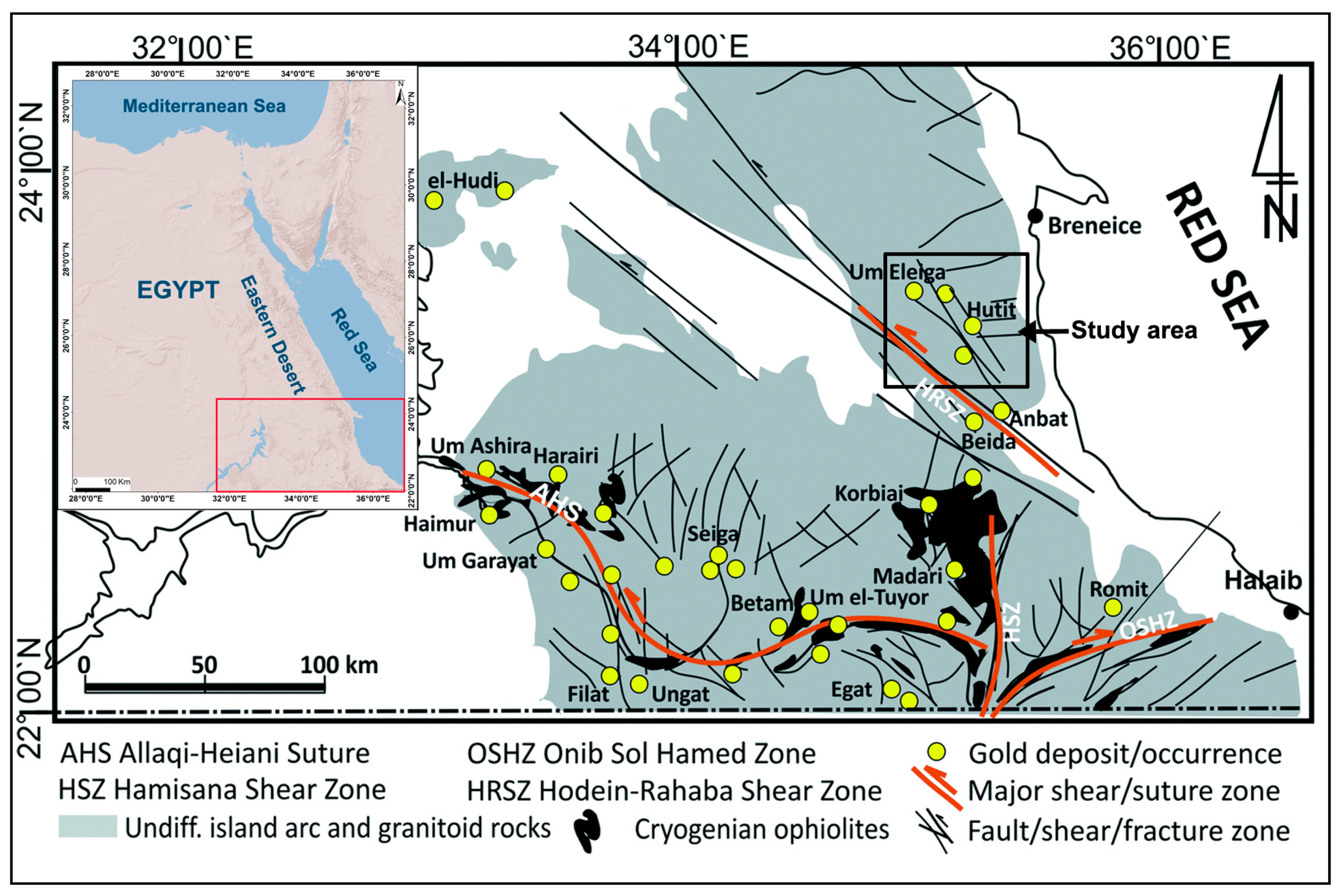
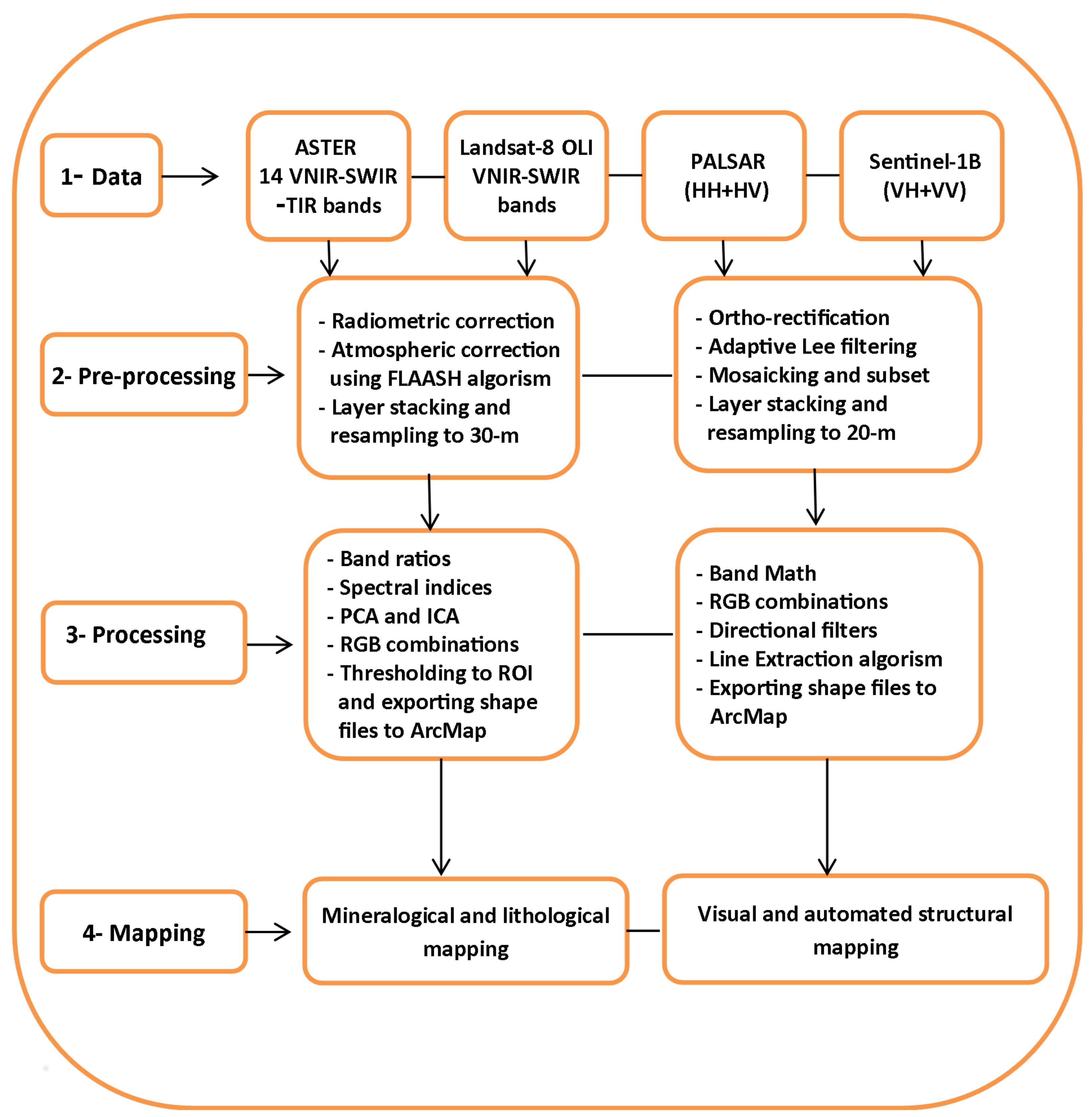
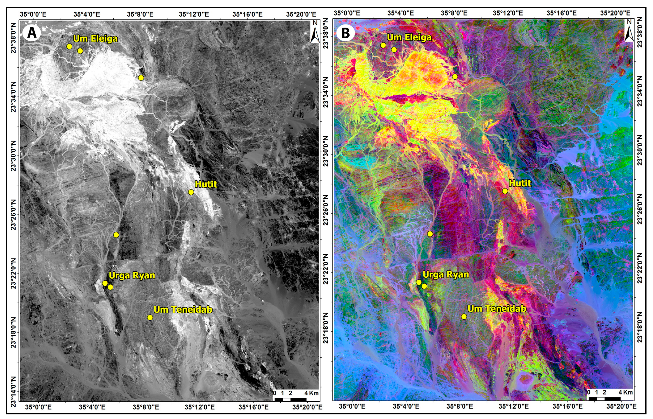
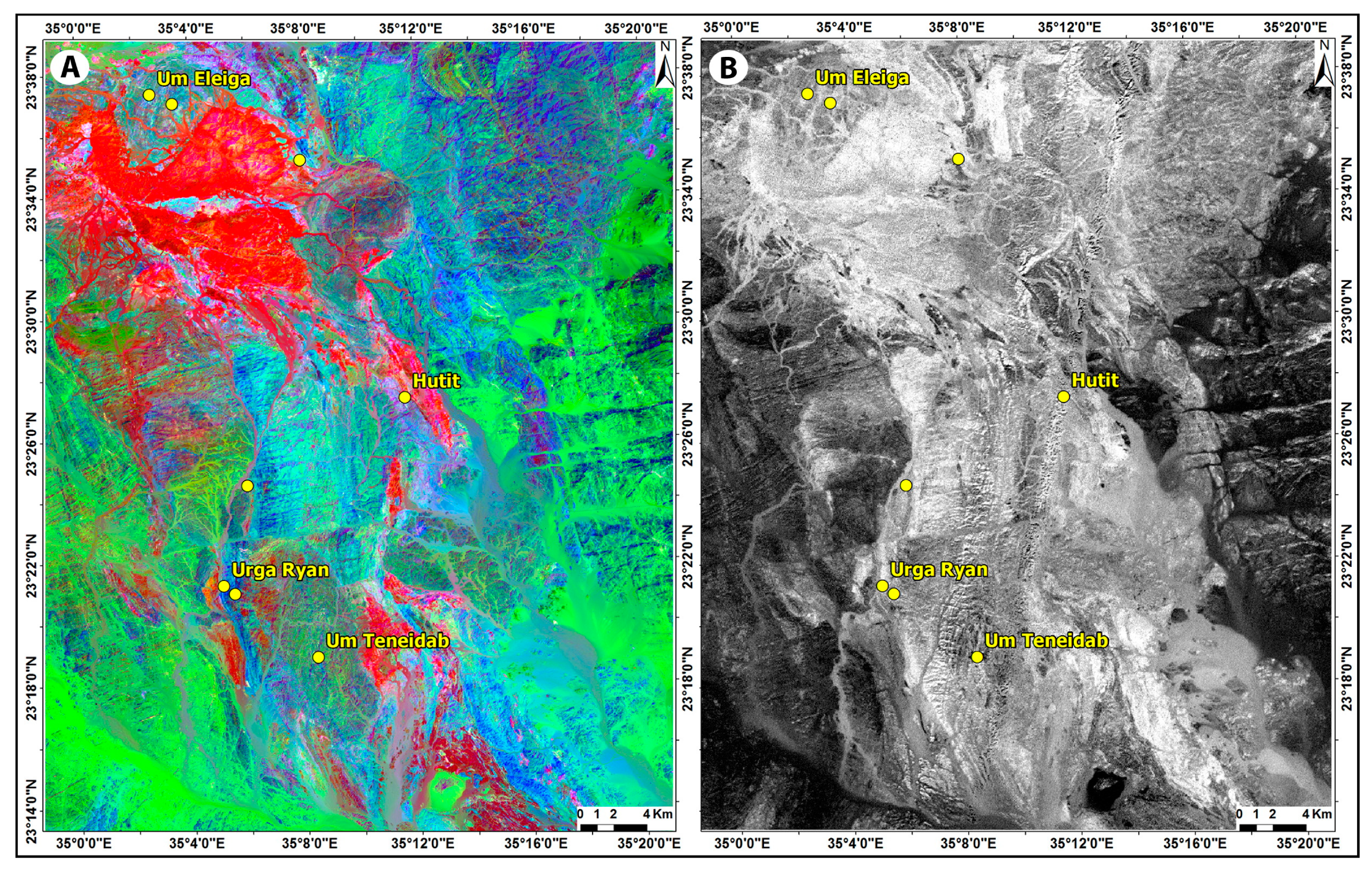
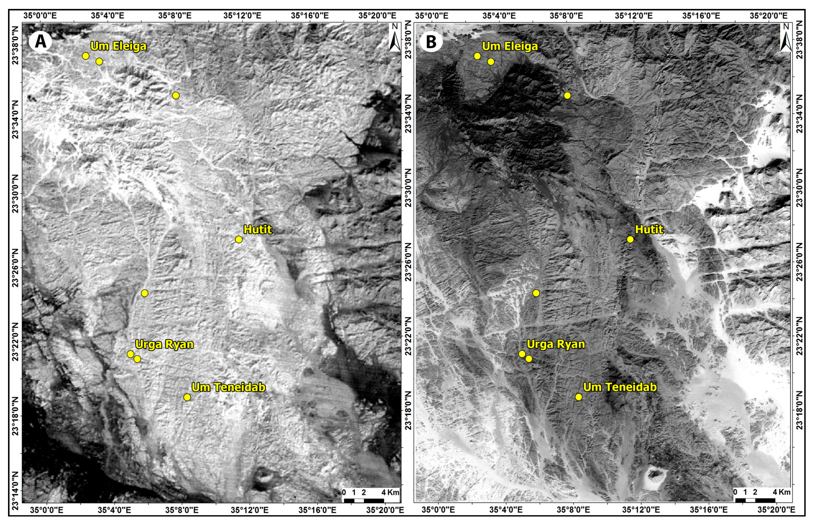
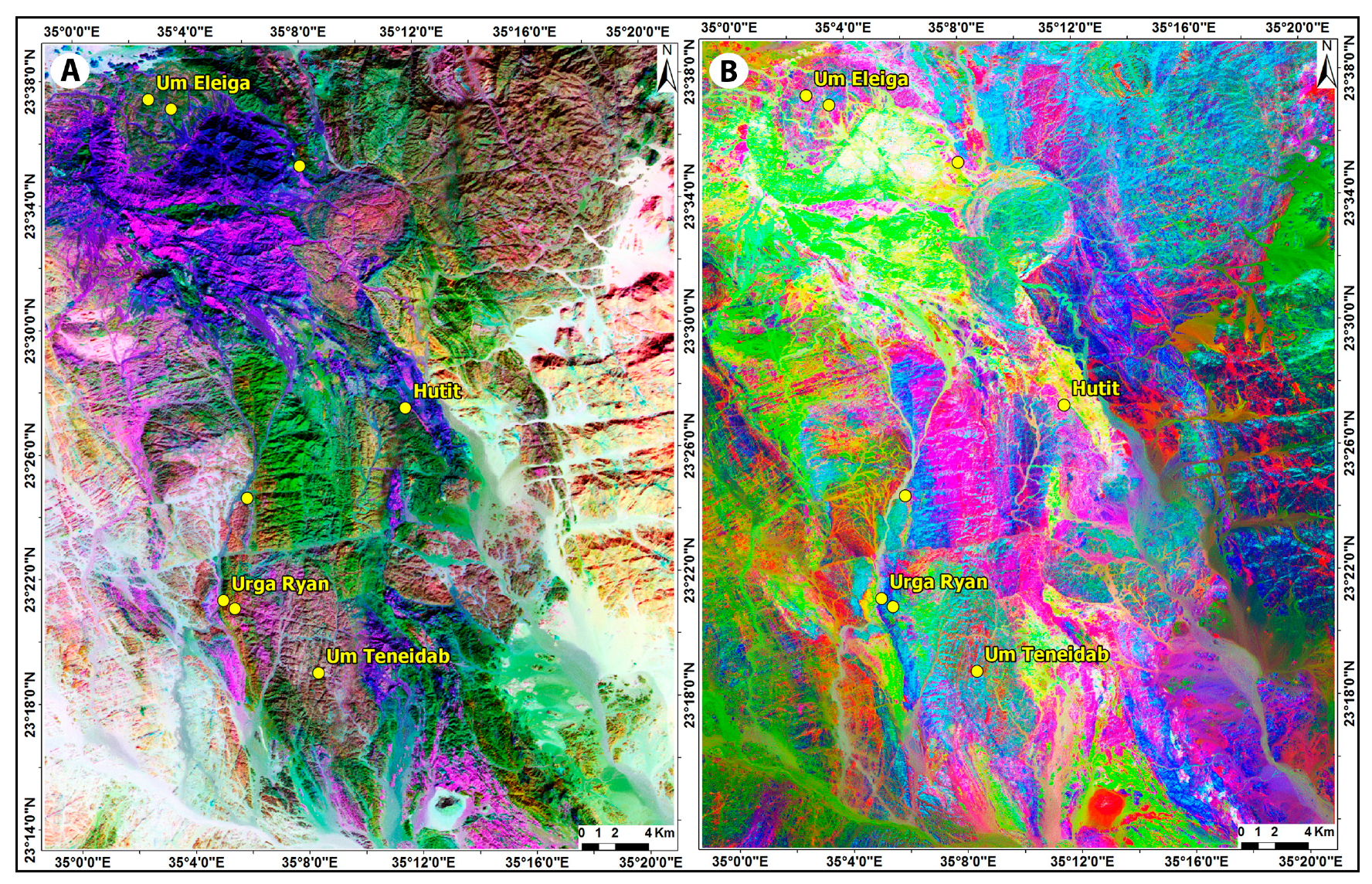
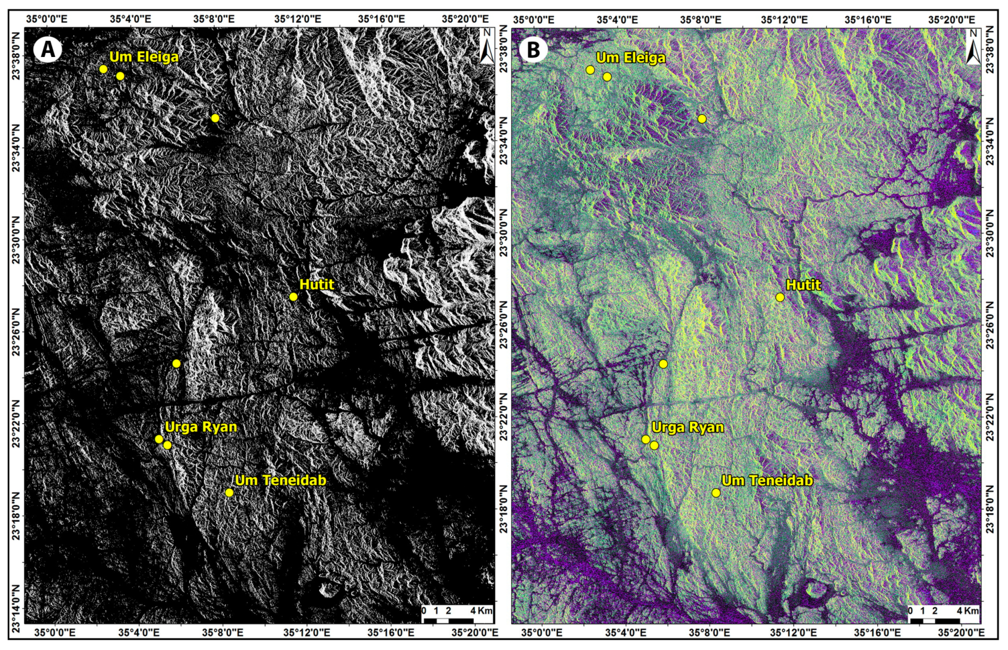
In this section, details of the significant gold occurrences in the study area are given. Aside from the comprehensive description of the geological setting of each of the gold occurrences, a pivotal emphasize is given to the deformation fabrics exhibited by the mineralized quartz veins and the structural elements observed in the mine areas and at the regional map scale.
4.1. Um Eleiga Gold Deposit
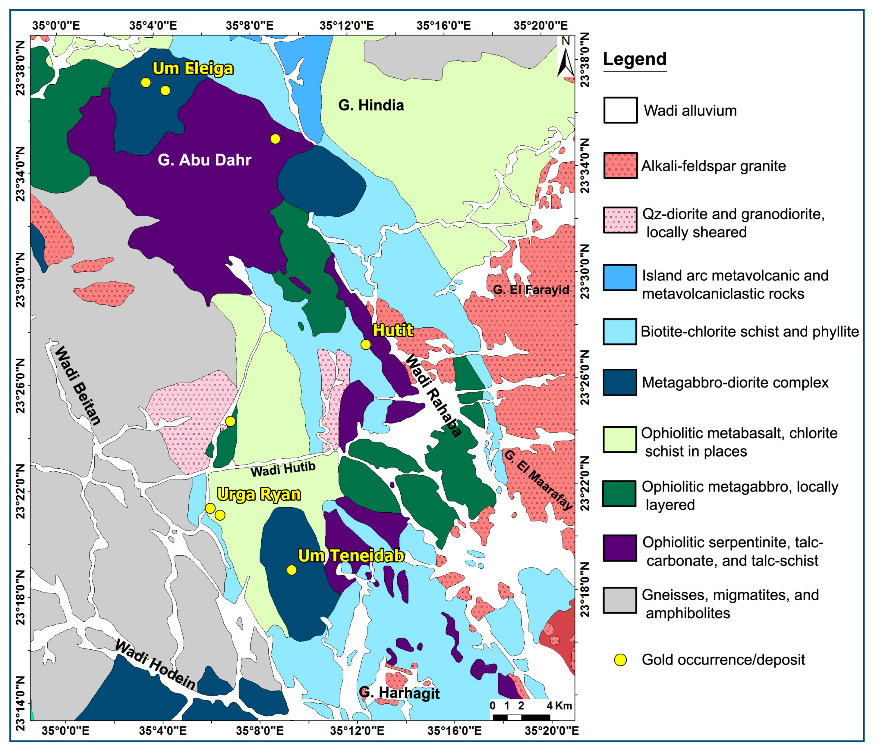
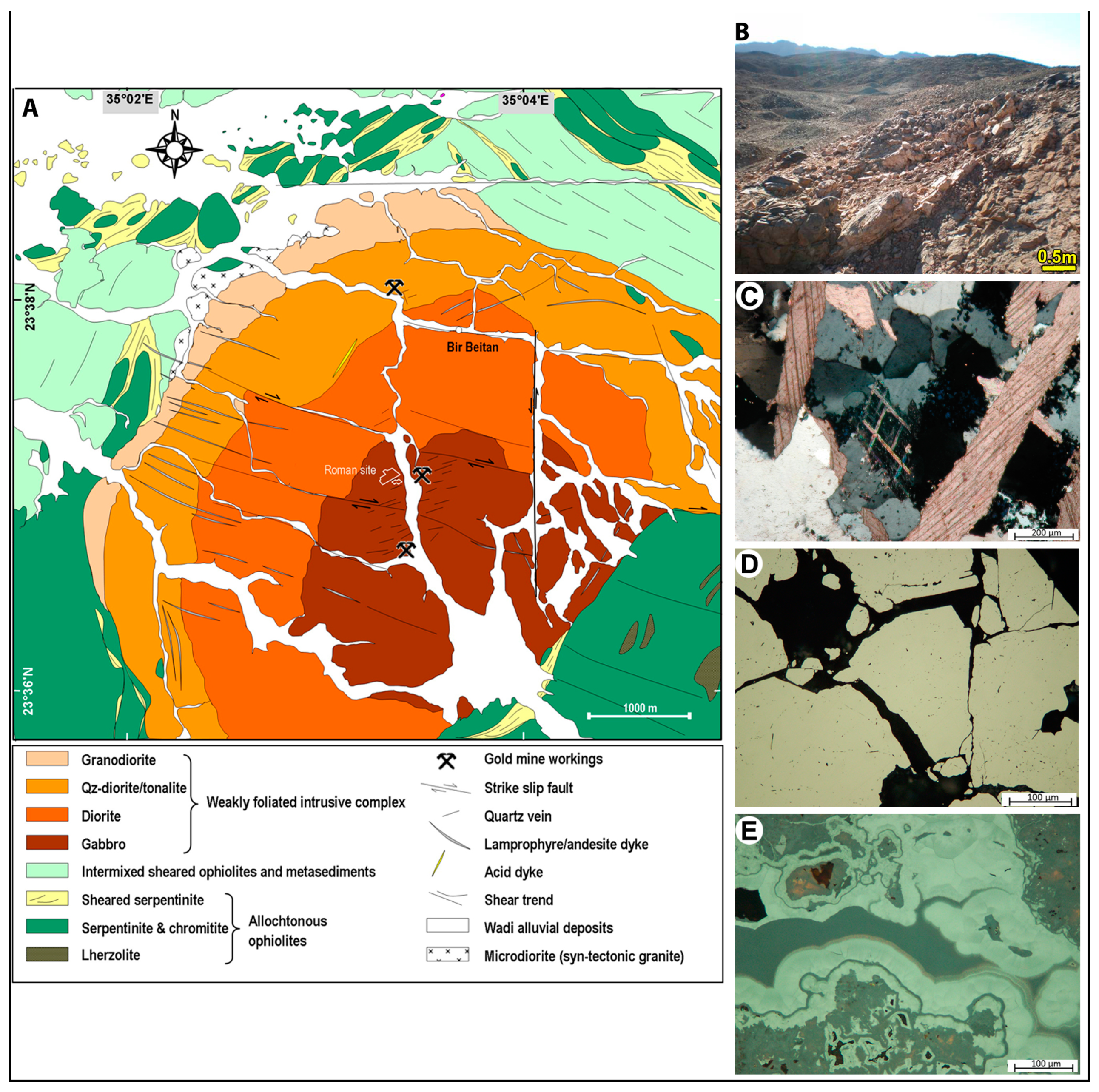
The Um Eleiga area, ~45 km west of the Red Sea coast, hosts a historic gold deposit in the SED. The gold mine lies along the NNW–SSE-trending Wadi Um Eleiga (
Figure 12A), where traces of placer mining and shallow pits, dumps, ancient mining camps, stone anvils, hammers, and grinding date back to the Roman–Byzantine and early Islamic times [
67,
68,
69]. Gold contents in quartz dumps collected from shallow pits grade as high as 28 g/t [
69], whereas the fine-grained alluvium at the base of the Wadi deposits/terraces yield anomalous concentrations of up to 36 g/t Au [
40,
70].
The Um Eleiga mine area is hosted by an elliptical, zoned intrusive complex (ca. 32 km
2) encompassing quartz–gabbro, diorite, tonalite, and granodiorite (
Figure 12A). The intrusive complex cuts through allochthonous ophiolitic blocks of serpentinite–chromitite (Gebel Abu Dahr) embedded in a highly tectonized matrix of pelitic and carbonaceous metasedimentary and metavolcanic rocks (see
Figure 5A and
Figure 7A). The different rock varieties in the complex are separated from each other by gradational contacts. WNW-, NNW-, and N-trending fault/fracture sets densely dissect the complex. The central part of the complex features olivine-, pyroxene-, and/or hornblende-rich gabbros, whereas diorite surrounds the gabbroic core and locally shows a distinct porphyritic texture. Tonalite and granodiorite form the outer parts of the complex. A small body of albitized microdiorite and sets of lamprophyre and andesite dykes cut the western parts of the complex. In the eastern part, the highly tectonized gabbro and diorite contain intensely kaolinitized and oxidized zones in which massive and disseminated goethite, malachite, and azurite are abundant.
The mineralized quartz veins trend mainly NE–SW or ENE–WSW and cut the gabbroic rocks in the central part of the complex and extend beyond the gabbro–diorite boundary (
Figure 12B). A later barren generation of N-, NW-, and E-trending quartz veins are restricted to fault intersections and tension gashes in the highly deformed gabbroic rocks. Zoheir et al. [
71] suggested that fault/joint intersections are the main structural control of intensely hydrothermal alteration zones and high gold contents in the central part of the Um Eleiga complex. The E-trending fractures cutting the gabbroic rocks are locally associated with chlorite–calcite and chalcedonic quartz alteration assemblage. Sulfide-bearing quartz veins (5–40 cm thick) cutting the gabbro–diorite complex are scarce, and cannot be compared with the extensive old workings. It is herein considered that the old miners worked quartz veins, scattered quartz blocks, and the friable wadi alluvium underneath the consolidated terraces. These milky quartz veins have brecciated borders in which quartz fragments are cemented by chalcedonic quartz, calcite, chlorite, and sulfides (
Figure 12C).
Gold-bearing quartz dumps enclose chlorite–sericite–calcite selvages and pyrite–malachite–limonite gossans (
Figure 12D,E). The main ore minerals are pyrite, chalcopyrite, sphalerite, pyrrhotite, and gold. Pyrrhotite and sulfarsenide form scarce primary inclusions, whereas pyrite, chalcopyrite, sphalerite, and free gold are late in the paragenetic sequence. Pyrite forms disseminated euhedral to subhedral grains with pyrrhotite inclusions. Chalcopyrite and sphalerite are intergrown with subhedral pyrite grains and also occur as inclusions in pyrite grains. Free-milling gold blebs and specks occur along fine ribbons and selvages of wallrock enclosed in the quartz veins. Hydrothermal alteration phases associated with gold–sulfide quartz veins include fine-grained quartz, chlorite, calcite, sericite, rutile, and sulfides. These hydrothermal minerals are clearly late relative to the igneous paragenesis of the host zoned intrusion. Pyrite, chalcopyrite, and sphalerite are disseminated in domains of pervasive quartz–sericite–chlorite alteration.
4.2. Hutit Gold Occurrence (Also Known as Huzama or Rahaba Mine)
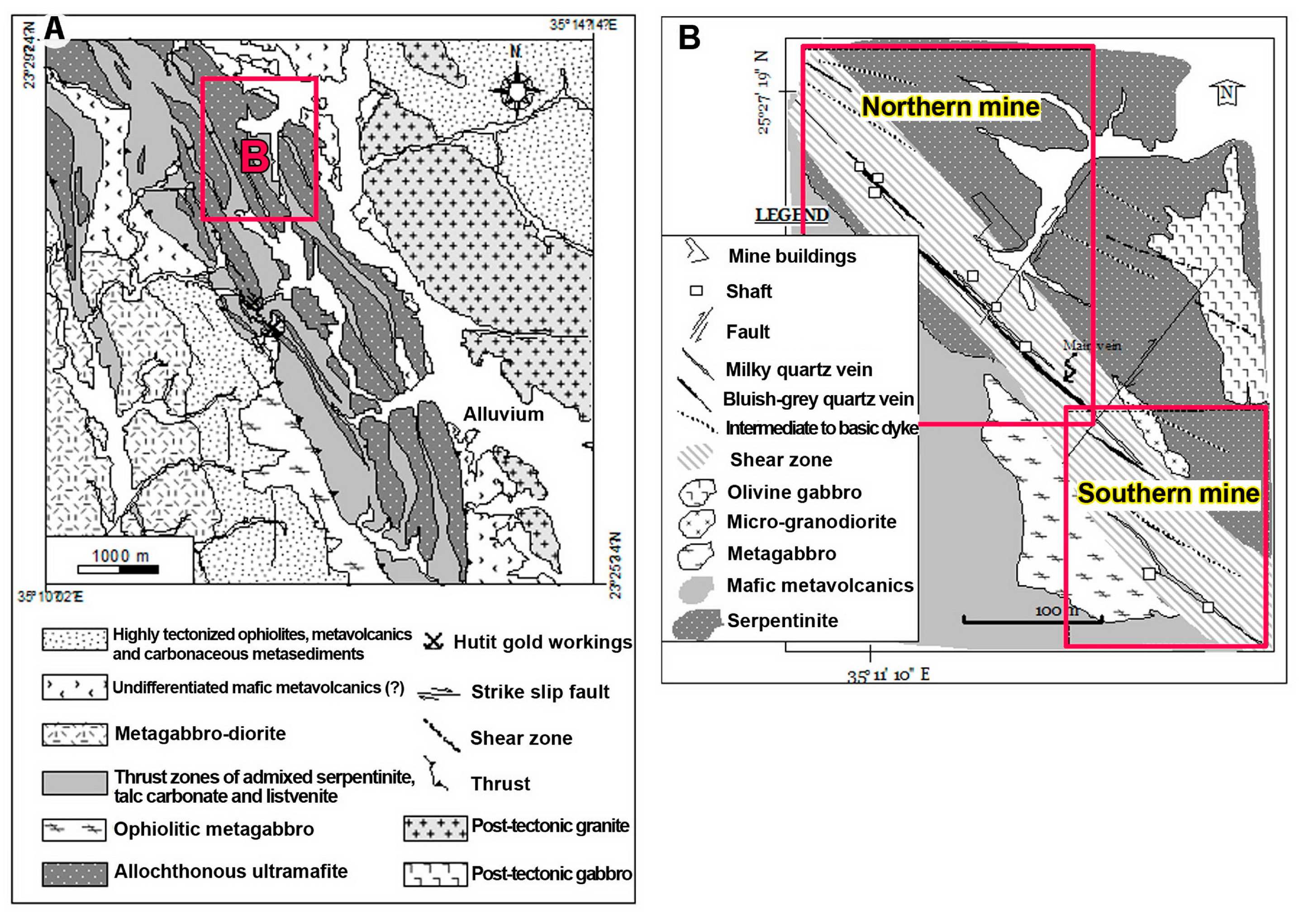
The Hutit gold occurrence lies between the head of Wadi Huzama and Wadi Hutit, a small tributary of Wadi Rahaba (
Figure 13A). The mine area is occupied by conspicuous, high to moderately elevated hills of serpentinite, mafic metavolcanics, and pelitic/psammopelitic metasedimentary rocks. Old mining in the area dates back to the early 20th century, but millstones from diorite and gabbro point to old workings, possibly from the Islamic times (seventh to eighth century). Recently, exploration mapping, structural survey, rock chip, and trench sampling, complemented by a ~30,000-m diamond core drilling program completed by Thani Ashanti (now Thani Stratex Resources Ltd.) between 2009 and 2013, indicate an in-house, non-Joint Ore Reserves Committee Code (non-JORC) resource estimate of ~0.5 Moz gold (
http://thanistratex.com/projects/projects-overview/).
The old miners extracted the ore bodies from two main (northern and southern) mines. The mine area was mapped at the 1:1000 scale and the mine area was subdivided into northern and southern [
69]. Abundant remains of grinding and separation plants are observed in the northern mine (
Figure 13B). Nevertheless, the preserved crusher stages, leaching basins, and loading station in the southern mine reflect significant mining activities in the past. In both mines, a main entrance through a horizontal ~E–W adit leads to the veins at a distance of 20 or 35 m.
The gold-bearing quartz veins occur along the contact between elongate allochthonous serpentinite masses and successions of intercalated metavolcanic and metasedimentary rocks. Field criteria indicate that these rocks are tectonically intermixed and intercalated with graphite-bearing schists forming a distinct mélange unit, in which serpentinite blocks are embedded. Contacts between the serpentinite blocks and the underlying rocks are zones of intensive shearing, grain size reduction and abundant talc-, quartz-, and carbonate- rich rocks. Serpentinite is composed essentially of antigorite, relict olivine, subordinate talc, calcite, tremolite, and minor chromite and magnetite. In the sheared horizons, no relics of olivine or pyroxene are found, where the rocks are composed mainly of antigorite and talc. Blocks of ophiolitic metabasalt and metagabbro are embedded in the sheared matrix and stretched parallel to the NW–SE foliation (
Figure 13B).
Alternating mafic metavolcanic and metasedimentary rocks prevail in the northern mine. The mélange rocks are characterized by moderate to high deformation, especially in proximity to the large faults. The elongation of clasts within the mélange matrix locally defines a moderately north-northwest plunging lineation. The metavolcanic rocks are mainly dark-colored, foliated, and slightly or intensively contorted. These rocks occupy the western part of the mine area and form an NW–SE-trending belt. The intact massive blocks of these rocks assume basaltic and ultramafic protoliths (
Figure 13C,D). The schistose varieties are mainly tremolite–actinolite and chlorite schists. They are intercalated locally with bands of metasedimentary rocks (i.e., metasiltstone and metamudstone), composed essentially of chlorite ± biotite, epidote, and quartz. These schistose rocks are graphite-bearing, especially in the northern part of the mine area.
An NNW–SSE elongate intrusion of gabbro cuts into the tectonized serpentinite in the northern mine. Small masses of micro-granodiorite dyke-like bodies (NW–SE), and dykes with different compositions cut the country serpentinite, metavolcanic, and gabbro rocks in the northern mine. Most of the dykes strike NW–SE, but a small number of the mafic dykes are NE-trending. Rhyodacite, dacite, and andesite dykes are generally porphyritic with tabular plagioclase and rhombic hornblende, embedded in a fine- to very fine-grained groundmass. The mafic dykes, mainly basalt to basaltic andesite, are notably abundant in the northern mine.
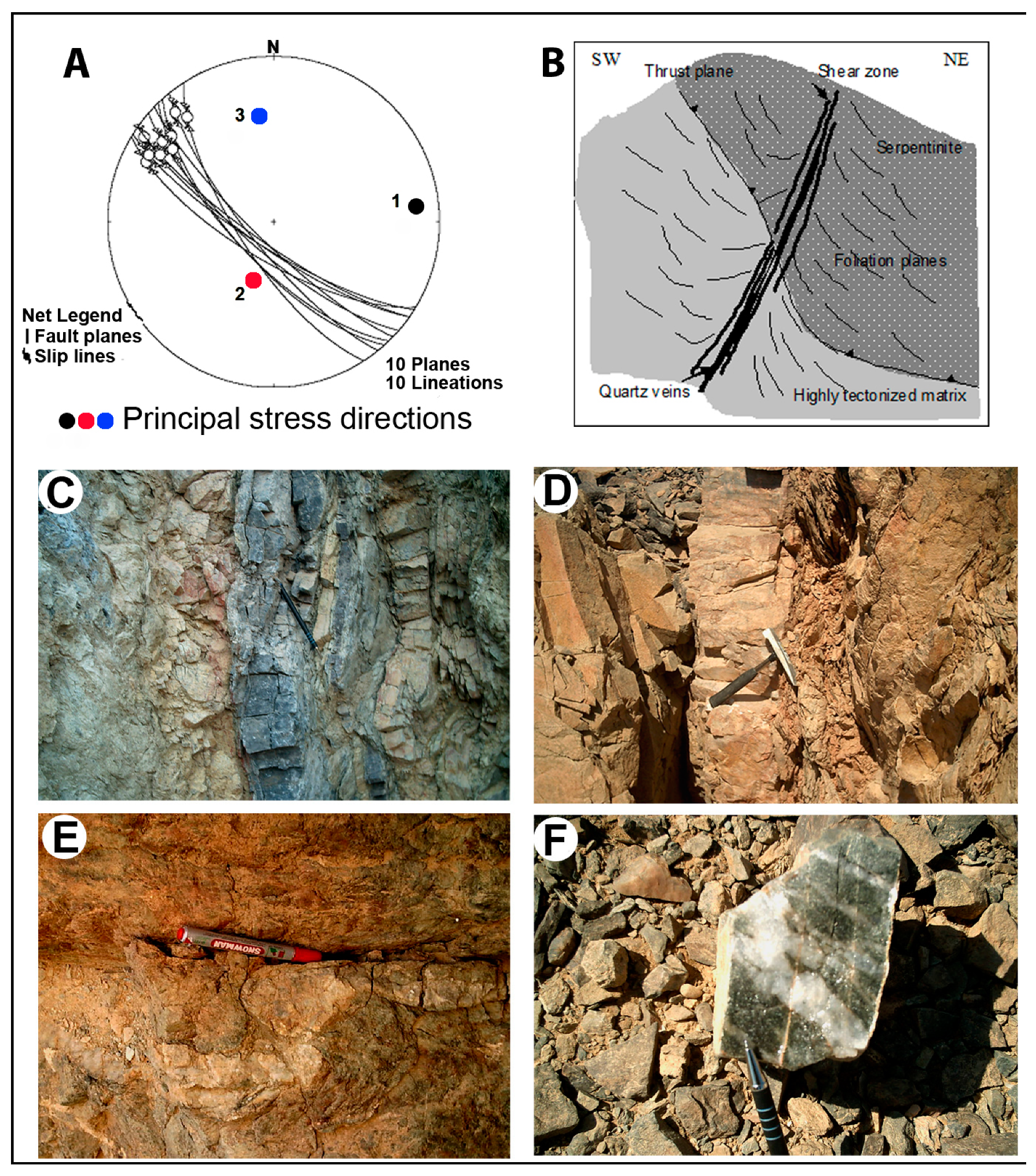
NW–SE thrust segments bound the ophiolitic serpentinite masses and dip moderately or steeply to the NE. Emplacement of the serpentinite slices is interpreted as being from east to west, constrained from moderately to steeply east-northeast dipping shear planes and consistently NW-trending stretching lineation, generally consistent with the W-directed tectonic transport of ophiolitic rocks in Wadi Ghadir area, north of the present study area [
7]. A kilometer-scale shear zone striking in an NW-SE direction is superimposed on the thrust zone and related fabrics. Analyzing the shear planes, asymmetrical fabrics, and slickensides indicates that this shear zone is a reverse fault zone (
Figure 14A), which accommodates a left-lateral displacement. Although nearly parallel to the thrust segments, this shear zone dips steeply to the west (
Figure 14B). Conjugate joints and faults are common in the northern mine. Fractures in the country rocks follow two main trends, N 40° E and N 50–60° W. No direct cross-cutting relationship was observed between the quartz veins and dykes.
The mineralized quartz veins occur along a 150-m-wide shear zone, where quartz veins have anastomosing and undulating morphologies, both down-dip and along the strike. The shear zone, quartz veins, and associated hydrothermal alteration overprint the metamorphic mineral assemblage and fabrics in the host metavolcanic and serpentinite rocks. Two types of gold-bearing quartz veins are reported in the mine area, including bluish-gray and milky quartz veins. In the northern mine, a 180-m-long bluish-gray quartz vein varies in thickness from less than 30 up to 150 cm [
69]. It strikes parallel to the shear zone (NW–SE) and dips 80° SW in the northern mine. This vein is made up mainly of gray quartz, carbonate, and subordinate colorless quartz and rare sulfides. The main entrance, along an adit from east to west, was used to work out this vein. A milky quartz vein of 20–50 cm thickness and 90 m length occurs in the vicinity of the main quartz vein. The bluish quartz veins are common in the northern mine, whereas milky quartz veins are rather dominant in the southern mine. The banded appearance of the bluish quartz veins (
Figure 14C) and their association with intensively altered host rocks, with abundant signs of strain and the absence of gashes and tensional gaps, suggest that these veins were formed under a compressional stress regime through formation of the shear zone. Asymmetric bent quartz lenses (
Figure 14E) provide signs of left-lateral shearing, but sub-vertical slickensides along the vein walls also corroborate the reverse nature of the shear zone. Field observations indicate that the milky quartz veins are younger than the bluish-gray quartz veins, on the basis of cross-cutting relationships (
Figure 14F).
The bluish-gray quartz veins are surrounded by carbonated, ferruginated, and less commonly kaolinitized wallrocks. The milky quartz veins in the southern mine are commonly surrounded by sericite–chlorite and less commonly epidote where they cut through metavolcanic rocks. In both types of quartz veins, signs of plastic and brittle deformation are abundant. Sub-grain development is the most characteristic feature of zones where the quartz veins are narrow and branchiate. Ribbon-shaped grain formation and less commonly mortar texture are also observed in the quartz veins. All interstitial quartz grains show undulatory extinction, deformation bands, and minor development of tiny equidimensional recrystallized grains around grain margins.
The mineralogy of the quartz veins also includes arsenopyrite, pyrite, and less commonly gold. Both arsenopyrite and pyrite are usually altered into goethite. In this case, appearance of tiny gold, streaky or wire-like particles along the rhythmic zones of goethite is common. This indicates that oxidation led to remobilization of structure-bound gold from pyrite and arsenopyrite to form native gold in secondary sites. Data concerning the ore grade include fire assay concentrations of some samples from the grayish and milky quartz veins. Gabra [
70] reported 1–40 g/t in quartz veins from the northern mine and 1–36 g/t in samples from quartz veins intercalated with sheared rocks in the southern mine. Takla et al. [
72] analyzed samples from the two different types of quartz veins and reported an average of 20 g/t. They also investigated the hydrothermal alteration zone for its gold content and indicated that the adjacent altered wallrocks contain 8 g/t Au on average [
72].
4.3. Um Teneidab Gold Mine (Also Known as Um Kalieb or Um Kalieba Mine)
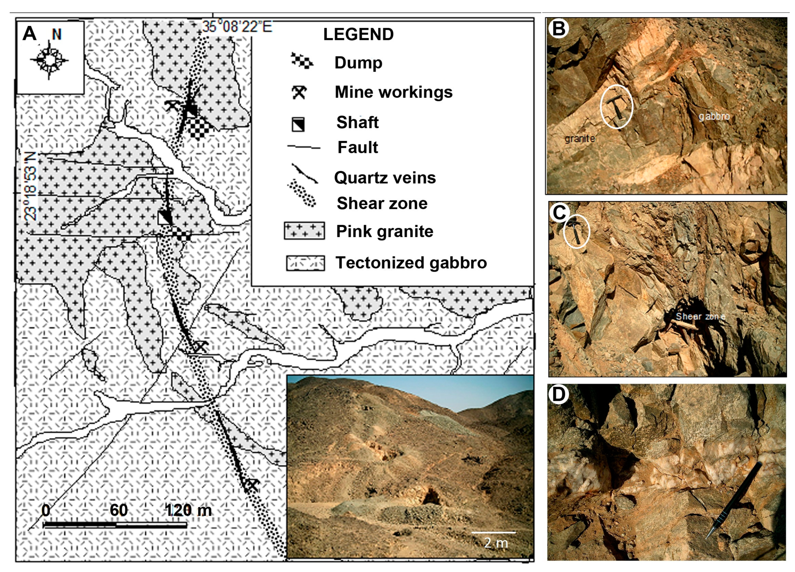
The Um Teneidab mine is situated 3 km west of Gebel Um Teneidab and 13 km southwest of the Hutit mine. The Um Teneidab mine area is underlain by gabbroic rocks that are cut by abundant offshoots of fine-grained granite (
Figure 15A). The contact between granite and the gabbroic host rocks is irregular and sharp (
Figure 15B). The area was mapped at the 1:1000 scale and these rocks are assigned as metagabbro–diorite and late-orogenic granite [
69]. Takla et al. [
72] discussed the features in detail, implying that these rocks belong to the younger gabbroic rocks of the Egyptian basement complex. In the present work, we agree with Hassan and El-Manakhly [
69], and classify the gabbroic rocks in the mine area as an island arc-metagabbro–diorite complex. This interpretation is based on some local foliated textures, a corona texture with brown hornblende bounding hypersthene crystals, and presence of more differentiated bosses with diorite composition.
Chlorite is common as an alteration mineral after the ferromagnesian mineral constituents of the host gabbros. The granitic rocks are composed of andesine, orthoclase, quartz, and intensively chloritized biotite. Approaching the quartz veins, plagioclase is more or less completely replaced by sericite and kaolinite. Pyrite is most common as alteration mineral disseminated in the hydrothermally altered granite and gabbroic rocks. Alteration is pervasive where the tectonized gabbro is densely seamed with granitic offshoots.
Structurally, the Um Teneidab mine area is traversed by conjugate NW–SE and NE–SW fault sets. Faults with no obvious lateral displacement dissect the granite body and offshoots in the western part of the mine area. Stretching lineation and slickensides along the quartz vein walls suggest that the shear zone experienced also little ductile deformation (
Figure 15C). Formation of this shear zone is attributed to the competence heterogeneity between coarse-grained gabbro and fine-grained granite. Granularity gives additional cohesion contrast that might proceed to a discontinuity zone or plane between these two different lithologies. Abundant quartz veins and felsic dykes are controlled by NW–SE shear/fault sets, but show no direct cross-cutting relations. Deformation is intense in zones where the granite offshoots traverse the gabbroic rocks.
Gold in the Um Teneidab mine area is related to a system of 10–40-cm-thick milky quartz veins extending for more than 200 m along a wrenched shear zone (
Figure 15A). These veins are NW- or NNW-trending and are commonly sub-vertical. The main lode is a zone of stockwork of veinlets (70 cm wide) bounded by hydrothermally altered wallrocks forming together a ~2-m-wide mineralization zone. The granite is notably sericitized and silicified close to the quartz veins (
Figure 15D). The latter are massive, composed of coarse-grained quartz crystals locally fractured and filled with newly formed quartz, characteristically colorless (less than 3-cm-wide veinlets).
Most quartz veins in the mine area, particularly the thin ones, are completely recrystallized. Porphyroclasts embedded in less recrystallized, mosaic-like, strain-free quartz are observed along the flanks of quartz veins. The quartz porphyroclasts are lensoid and show strong undulose extinction, deformation lamellae, and sub-grain development; they contain numerous fluid inclusions of various generations. The boundaries of the shears are sharp, and the sulfides are clearly confined to zones of shearing and alteration.
Gold is disseminated as flakes in altered pyrite, associated with galena or as fillings in the microfractures of the quartz veins. Gold is also present in the hydrothermally altered wallrocks, i.e., the altered granite (quartz–sericite rocks). Less commonly, relics of pyrite are seen disseminated in the quartz veins, whereas gold wires along rhythmic zones in goethite are accidently seen. Gold occurs as native globules disseminated in the quartz veins, mostly along the grain boundaries. The quartz veins contain from <1 up to 30 g/t gold, with an average of 8 g/t in the altered wallrocks [
72].
4.4. Urga Ryan Gold Occurrence
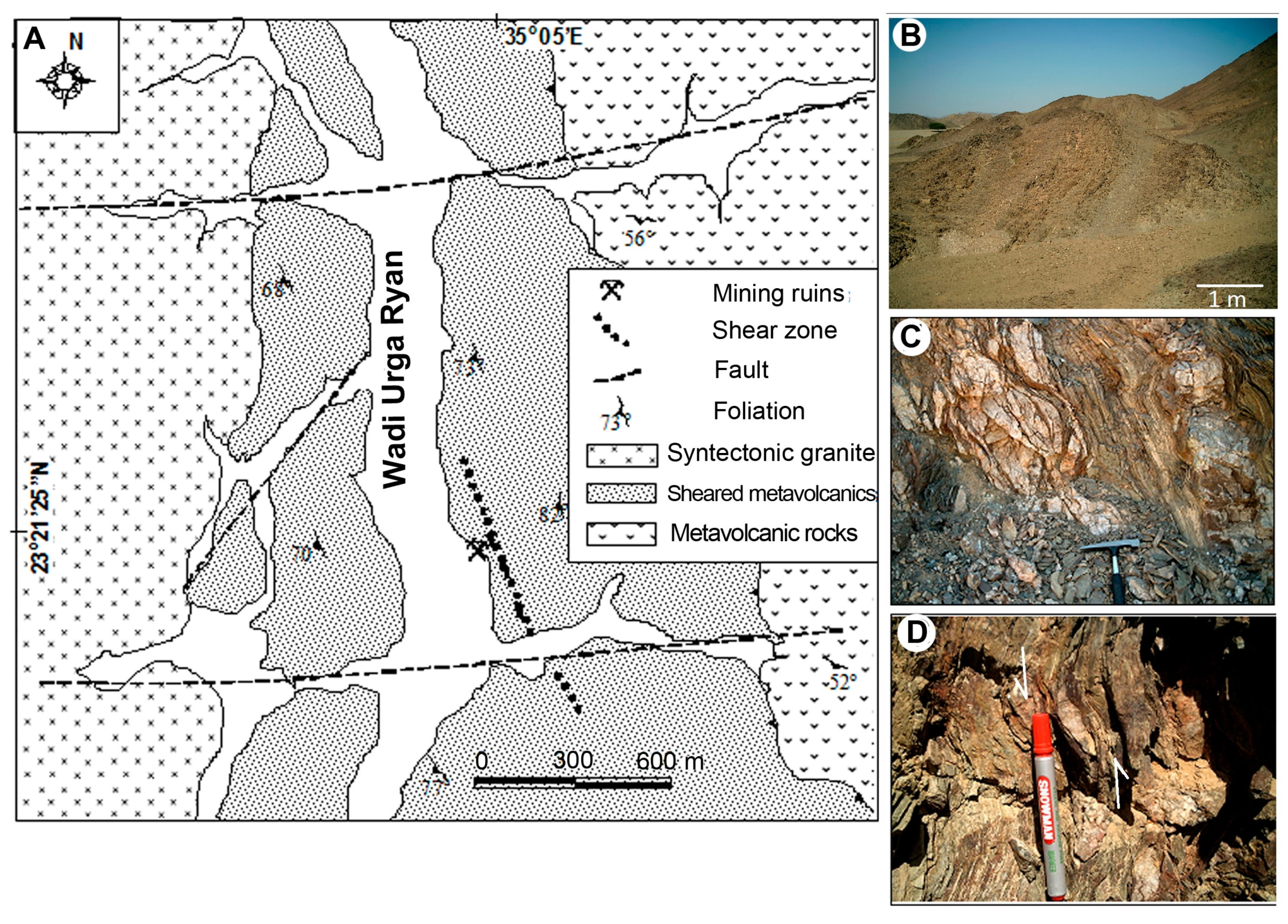
The Urga Ryan gold occurrence is located 17 km SW of the Hutit mine, ~10 km west of Gebel Um Teneidab. The location is ca. 2.5 km south of the intersection of the E–W Wadi Hutib and the nearly N–S Wadi Urga Ryan along the main wadi. The area surrounding the Urga Ryan occurrence is underlain by island arc-metavolcanic rocks, dominated by metaandesite and epidote–chlorite schist (
Figure 16A). The metavolcanic sequence is locally affected by a several kilometer-scale shear system that led to intense shearing in an NNW–SSE direction overprinting the WNW–ESE schistosity of the metavolcanic rocks. In the eastern part of the mine area, a large granitoid intrusion of granodiorite or quartz diorite composition cuts the metavolcanic rocks. The granitoid rocks are slightly foliated and tapered along the foliation in the metavolcanic rocks and enclose elongated enclaves parallel to the metavolcanic rock schistosity. The old mine workings are situated in a low hill terrane that is underlain by sheared metavolcanic rocks (
Figure 16A) along the main Wadi Urga Ryan, whereas mine houses spread over many tributaries around the area, likely reflecting considerable mine activities. The mineralization is, however, limited to small locations, particularly where the shearing is intense and quartz lenses are abundant.
The mineralization is confined to a local NNW–SSE shear zone, which dips steeply to westward, cutting across the sheared metavolcanic rocks (
Figure 16B). The main lode is composed of boudinaged quartz veins and lenses, ranging in thickness from less than 5 cm to 30 cm and extending along the strike for more than 40 m. The host shear zone exhibits features of brittle and ductile regimes manifested by mylonitization, asymmetric boudinaged quartz lenses, and partial recrystallization (
Figure 16C). The sense of shear along this shear zone is derived from the lensoidal quartz pockets that point to a left-lateral movement concurrent with vein emplacement (
Figure 16D). This observation suggests a spatial and temporal relationship between the shear zone and gold-bearing quartz veins.
The local dynamic recrystallization of the host metavolcanic rocks is assumed to have been strongly catalyzed by fluid flow through dilatant zones and promoted ductility-enhancing mineral reactions. These high-fluid-pressure features likely develop in rocks buried at great depths, indicating mesothermal conditions typical of orogenic gold deposits. In the mine area, hydrothermal alteration is confined to narrow zones of sheared wallrocks bounding the quartz veins and veinlets. The quartz veins gave a gold content ranging from 1–7 g/t [
70].


