1. Introduction
The term “equity” is originally derived from social science and represents one of the core contents of the “urban sustainable development” concept [
1]. Social equity refers to the distribution of public services, especially “popular services” such as parks, schools and so on, which should be allocated among different space units and different economic, racial and political groups in an equitable manner with special considerations made for the needs of special groups [
1,
2,
3]. The allocation of social resources should reflect equity in time and space; namely, it denotes intergenerational and intra-generational equity among different groups [
4,
5]. Adherence to social equity ideals represents the objective of the social value orientation. In a spatial context, the term could be defined and measured in numerous ways [
6]. For some researchers, spatial equity simply involves providing equal access to basic public service facilities as measured by distance [
7]. The definition of equity in relation to service distribution applied in this paper includes two aspects as follows: (1) horizontal equity (equality), in which everyone receives the same public benefit following the concept of social equity; (2) vertical equity, based on the different ability and demand of various social groups, whereby the specific socially vulnerable groups receive disproportionately more benefits [
8]. Talen argued that spatial equity involves considering needs, fairness and justice in the distribution of public service facilities [
9]. Overall, the term ‘spatial equity’ just focuses on the service level difference among a region’s public facilities while, the term ‘social equity’ pays more attention to the “spatial match” between the service level of public facilities and the distribution of the resident population.
Equity measure was generally calculated by the accessibility index using GIS to express the distance to and the cost people spent at (location of space unit mostly used) the facilities [
9]. Therefore, the accessibility difference of space units (smaller scale such as street, neighborhood, etc.) becomes the important index for the evaluation of spatial equity. Empirical research on the notion of equity in public service distribution focuses on defining and measuring equity and determining causal factors involved in the distribution of public service facilities [
10]. Urban ecological space is mainly composed of forest land and waters that have the important ecological service function of natural conservation, relaxation and vacation, forest protection, ecological protection and so on. It plays an important role in maintaining healthy and comfortable regional ecological environments, as well as the survival of mankind in urban areas [
11]. The social service function of public parks can be partly measured based on how easily (especially with respect to reaching nearby parks by walking) and equally residents can access and benefit from such space, and this is also an important indicator for measuring residents’ quality of life. Therefore, urban public parks’ layouts should be designed to support equitable and efficient supply of green space. In other words, this limited resource should be maximized so that individuals of all social hierarchies may enjoy equal access [
1]. However, while previous research has examined indicators such as per capita public green space and green space ratios for evaluating the service function of public parks, the literature has focused less on public parks’ spatial equity. What’s more, urban public parks as an ecological space agent for urban residents’ recreation, their spatial layout equity denotes a situation where residents of a planning area can access parks’ services regardless of socioeconomic status, desire, demand, population distribution and other factors. The term also emphasizes equal accessibility to urban parks for residents from different geographic locations.
The equity studies of public service abroad experienced three stages including regional equality, spatial equity and social equity. An abundance of previous research has been conducted on spatial equity. The research objects focused on various types of public facilities such as commercial service facilities [
12], health care facilities [
13,
14], education facilities [
15], cultural facilities [
16], parks [
17,
18,
19,
20,
21], sports facilities [
22] and other service facilities [
23,
24]. While in China, with the issuing of new urban planning establishment means by the Ministry of Construction at the end of 2005, the maintenance of social equity had started to be recognized as an important guiding principle, and especially in reference to the interests of low-income groups and socially vulnerable groups. Spatial equity studies on urban public service facilities are still in the initial stages in China and have mainly been focused on the fields of health care [
25,
26,
27] and education [
28]. The evaluation methods that are most commonly used in this line of research include range analysis, the Lorenz curve approach, the Gini coefficient method, the GIS spatial analysis method, etc. Urban public parks as the most important ecological space have developed into a special kind of public service facilities, and with significant attention being paid to social equity in western human geography, the accessibility and social equity of public parks is increasingly becoming a hot topic for academic discussion. Research conducted abroad has tended to focus on the socioeconomic attributes of a population and then analyzed differences in green space supply among different social groups based on single, multiple or comprehensive factors [
1]. Lindsey [
29] and Zhang Yangjian [
30] studied comprehensive factors that reflected the socio-economic status (SES) of groups to study the social equity of green space and found that the high-income, white and highly educated groups living in top communities enjoyed more green space, while socially vulnerable groups, such as the blue-collar, ethnic minority, and low-income groups living in bottom communities, enjoyed less green space. Gentrification is a form of urban renewal. It actually means that the high trend of the urban central community from the residents to the corresponding material conditions and environment. The potential negative externalities on the improvement of urban parks in deprived neighbourhoods was studied in western countries. Several authors showed in different urban contexts how the provision of new urban parks have fuelled displacement and gentrification processes (what has been called “green gentrification”) [
31]. Therefore, many public service facilities and consumer facilities (including parks) that serve for the high income groups enter the community through the process of urban gentrification. However, spatial equity research on public parks in China is still in its infancy [
32,
33,
34,
35]. The previous literature discussed the spatial equity layout of urban parks. More attention is paid to the equity of parks’ accessibility and supply and demand matching between different communities for vulnerable groups such as the elderly in China. Some studies focus that the ultimate goal is to have the same accessibility of minority groups and non-minority groups in the community, and even to provide a higher level of accessibility for low-income residents in spatial distribution in western countries [
9]. However, the previous literature mainly focuses on the parks’ accessibility and the socio-economic status of groups—few studies have comprehensively evaluated the spatial equity of urban parks through studying accessibility and demand indexes from the perspective of residents’ demands. Fewer scholars studied whether the blocks with higher accessibility are also the blocks that are relatively concentrated with higher demand groups, or whether the blocks with a high proportion of vulnerable groups such as children, the elderly and low-income groups have higher accessibility.
As for thoughts on ecological civilization construction—ecological civilization is based on natural respect and protection, takes the harmonious symbiosis among human-human, human-nature, human-society as its purpose, establishing sustainable production and consumption patterns as its content, and focusing on guiding people to get on sustainable and harmonious development path [
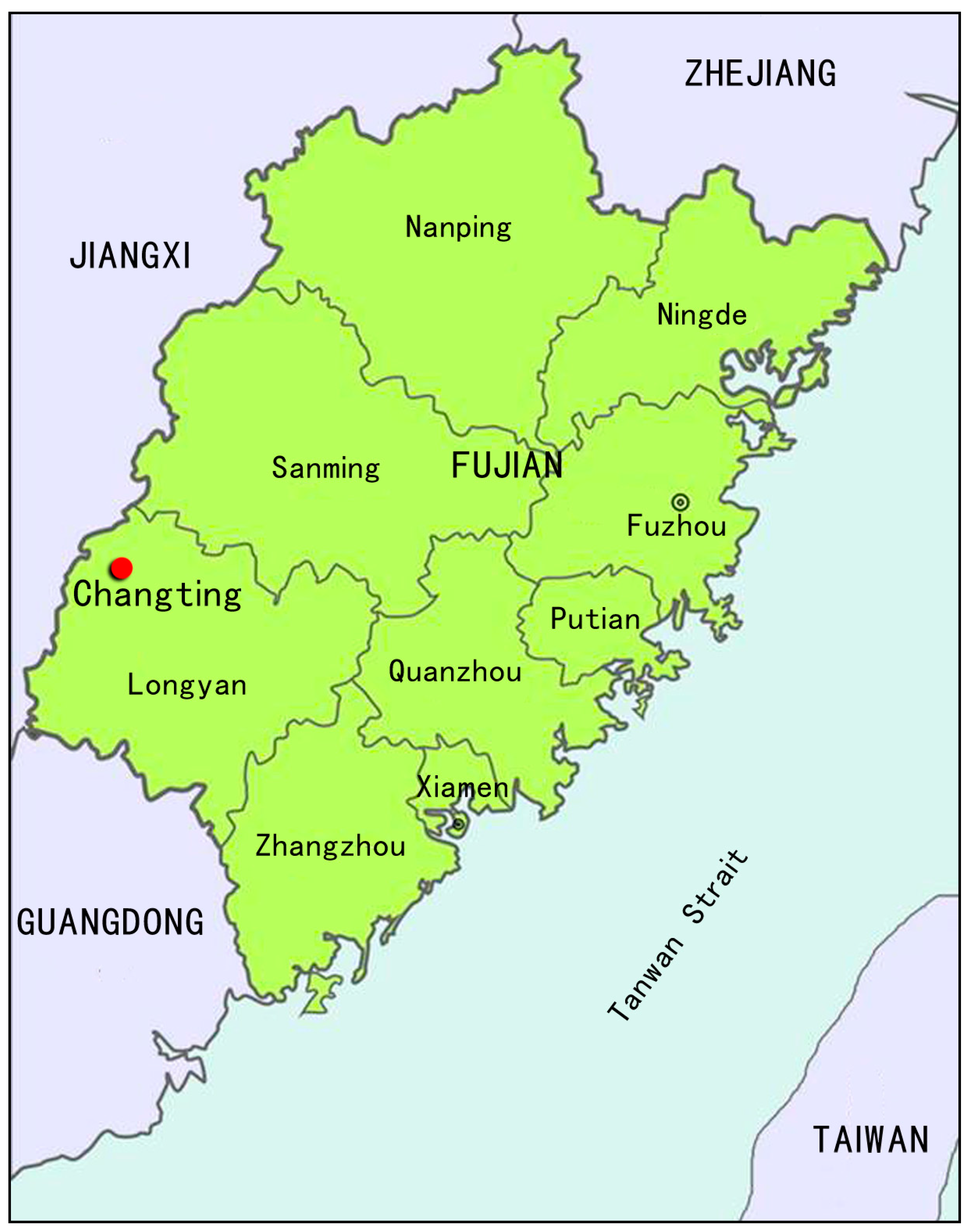
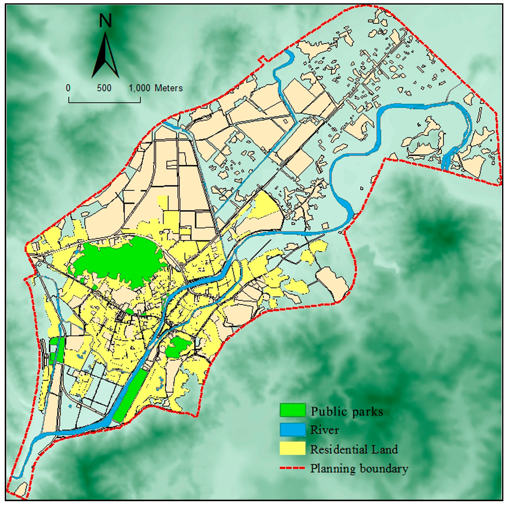
36]—ecological city and sustainable development concepts are becoming more and more embedded deeply into the hearts of people, the research on spatial layout equity of public parks which are special public service facilities is receiving the extensive attention of academic circles at home and abroad. With the rapid process of urbanization, income gaps among different social groups is widening in mountainous cities. Especially in old towns, lots of typical problems exist including higher population density, poor landscape environment of traditional old districts, concentration of the weak and old groups, and scarce community parks. The improper layout of urban public parks leads to a difference among citizens ability to share in this kind of public resource, and the inequity of park layouts is a common problem, particularly in historical districts of mountainous cities in China. Therefore, it is very meaningful to explore the social equity of urban ecological space layouts. In order to illustrate the concept of “people-orientation” and “social equity” in the context of urban construction, this paper takes the central urban area of Changting, which is a thousand-year-old ancient city in western Fujian, as the empirical object and studies the spatial equity issues of urban public parks based on the accessibility evaluation and the socially vulnerable groups demand index. It is a great challenge to arrange urban public parks reasonably within the limited urban construction land-use in Changting. Furthermore, we want to know whether the communities with a high level of accessibility are the communities where high-demand groups are also relatively concentrated, and whether the communities with a high proportion of socially vulnerable groups, such as children, the elderly and low-income groups have a higher level of accessibility. This paper intends to introduce the accessibility of public parks for vulnerable groups as the touchstone to test the spatial distribution equity and rationality of urban ecological spaces. Moreover, the paper will provide a scientific and feasible reference for urban public parks planning practices, to achieve the spatial equity of different social groups and social spaces, ease social contradictions caused by inequity, and promote the harmonious and sustainable development of mountainous cities.
5. Conclusions and Discussion
Urban parks as important urban ecological spaces provide residents with the best place for leisure and recreation, and they gradually become a “commodity” [
53]. Therefore, studies on the accessibility and spatial equity of urban parks are becoming particularly important. Especially, the layout equity of urban parks directly affect the quality of residents’ living environments on different streets—particularly the accessibility profoundly affects socially vulnerable groups including poor groups, the disabled, ethnic minorities, the elderly and children sharing public service facilities such as urban parks.
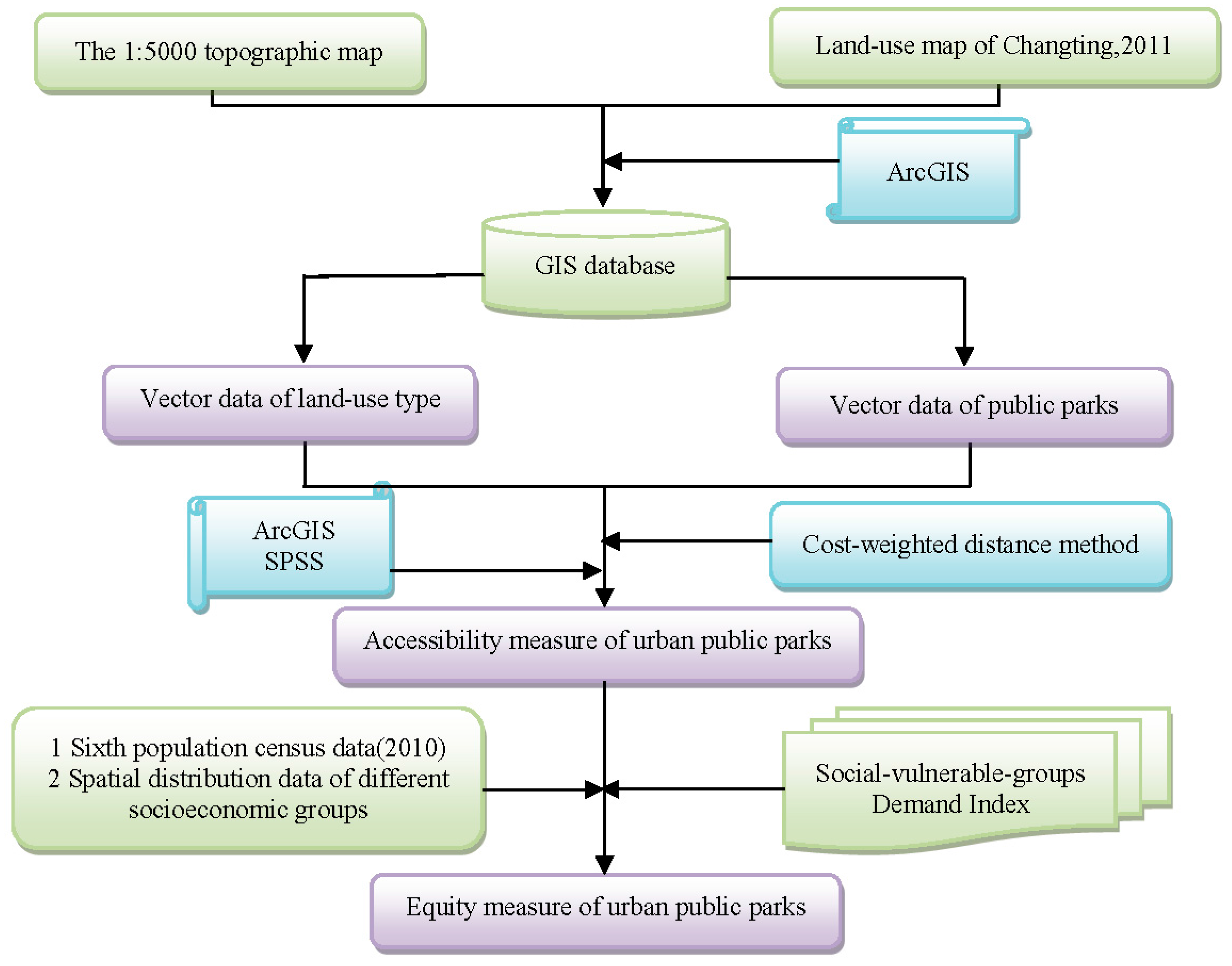
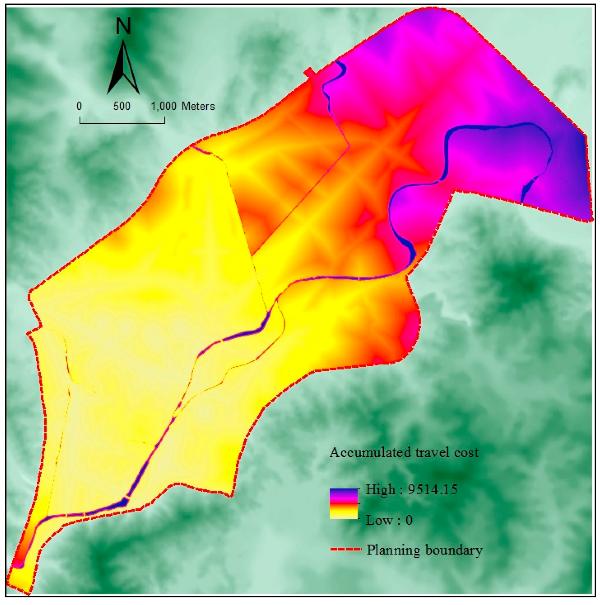
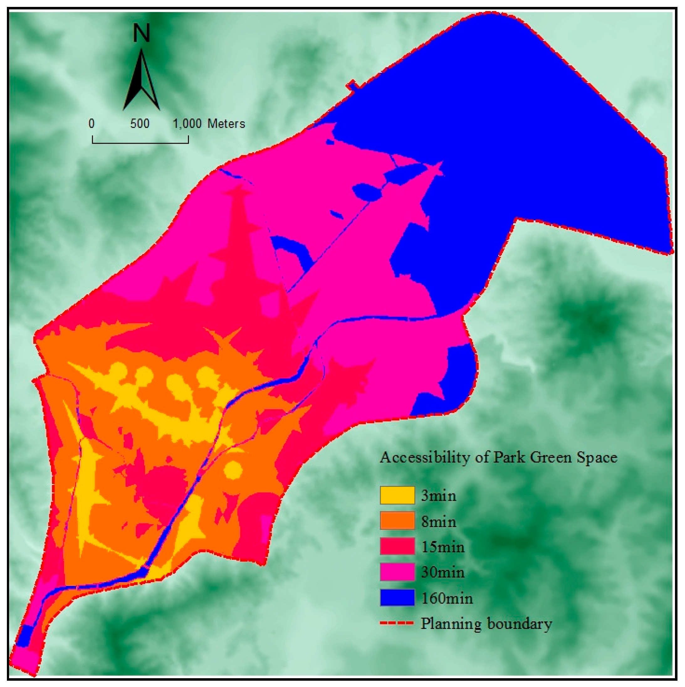
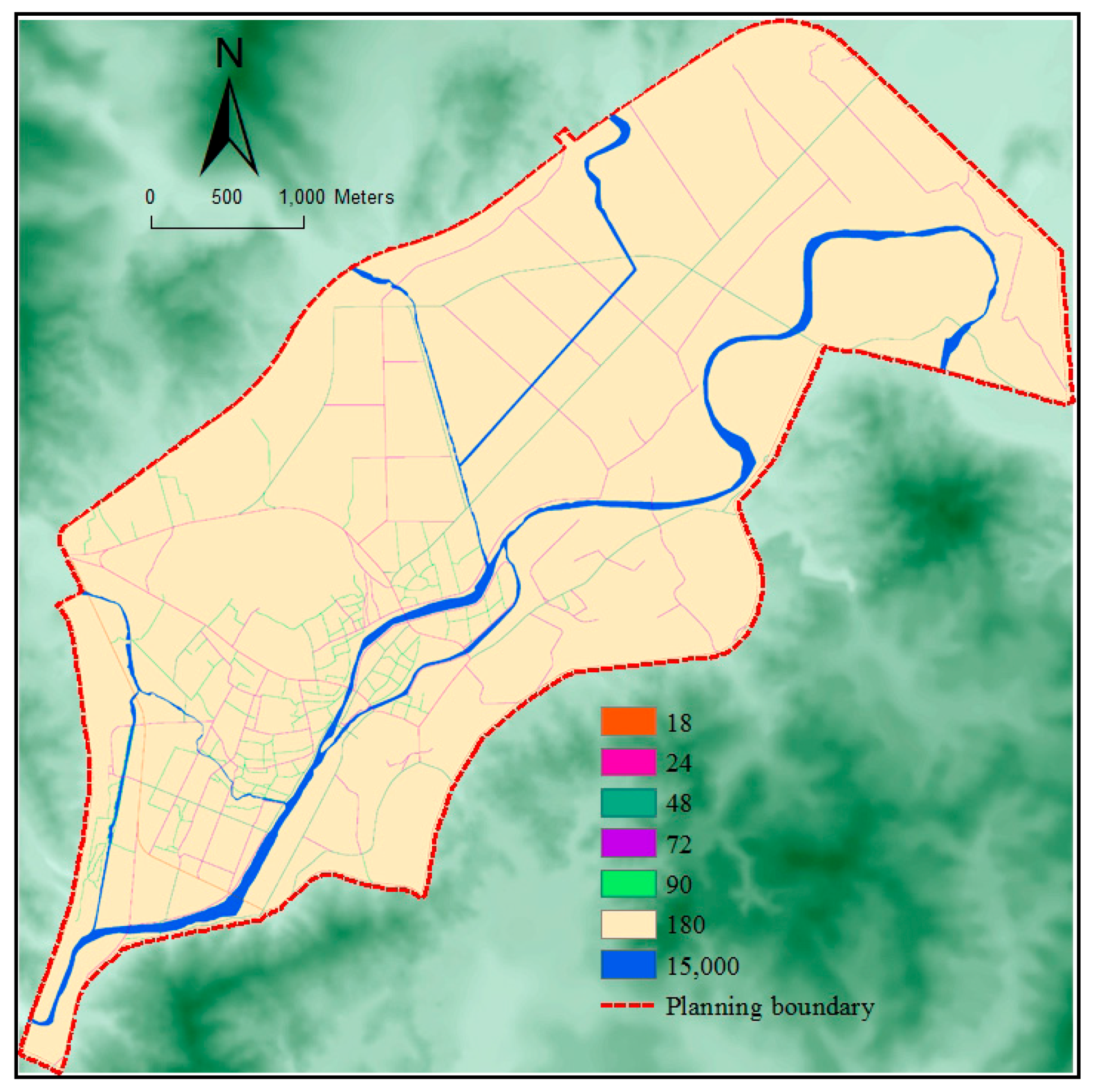
The method of park level to determine service radius usually adopted to examine the rationality of the spatial distribution pattern in China, that realizing a complete coverage of park service scope through planning. The main indicators include quantity, per capita area and spatial layout equalization of parks. Few studies have comprehensively evaluated the spatial equity of urban parks through studying accessibility and demand indexes from the perspective of residents’ demands. The central urban area of Changting is taken as an example in the paper. The cost weighted distance method is adopted to carry out the quantitative analysis for urban parks’ accessibility, and the sixth census data (2010) [
54] of Changting is combined to build the demand index, the demand for urban parks of residents is analyzed quantitatively. On this basis, the spatial equity of parks’ distribution in the study area is quantitatively measured by the two methods of sequencing variable correlation analysis and factor spatial overlay analysis. It not only evaluates the accessibility differences in different space units, but also considers the demands of different social groups. That is to say, the equity measure is based on different social groups, different areas, different demands and utilization modes (time limit), therefore the evaluation results are more targeted [
55,
56]. The results indicate that it is feasible to measure spatial equity of urban parks by the accessibility and demand index of socially vulnerable groups, and it can effectively characterize the rationality of urban ecological spaces. It can also provide useful decision-making guidance for urban planners in investigating, analyzing, and adjusting the distribution of public parks to achieve equitable outcomes. What’s more, the method of spatial equity measurement will be widely applied and provide an important referential significance for the reasonable planning and layout of other urban public service facilities, such as medical service facilities, schools, libraries, museums, and commercial shopping centers. Overall, our major conclusions are listed as follows:
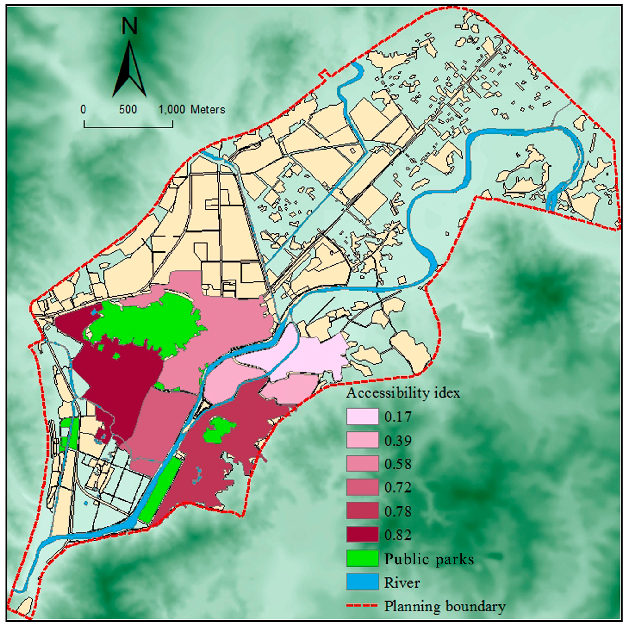
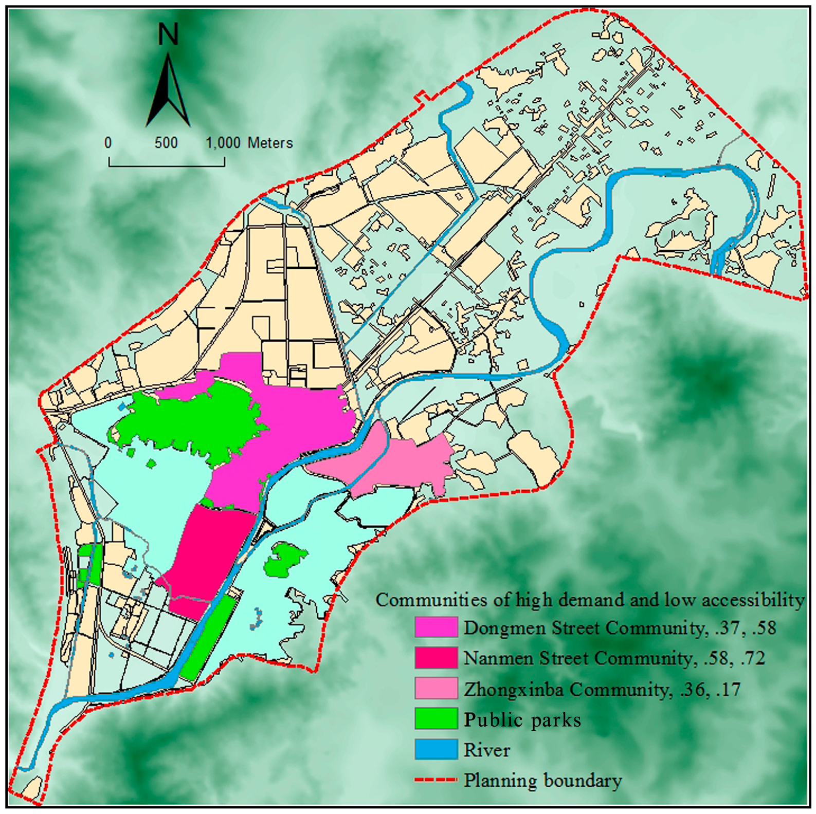
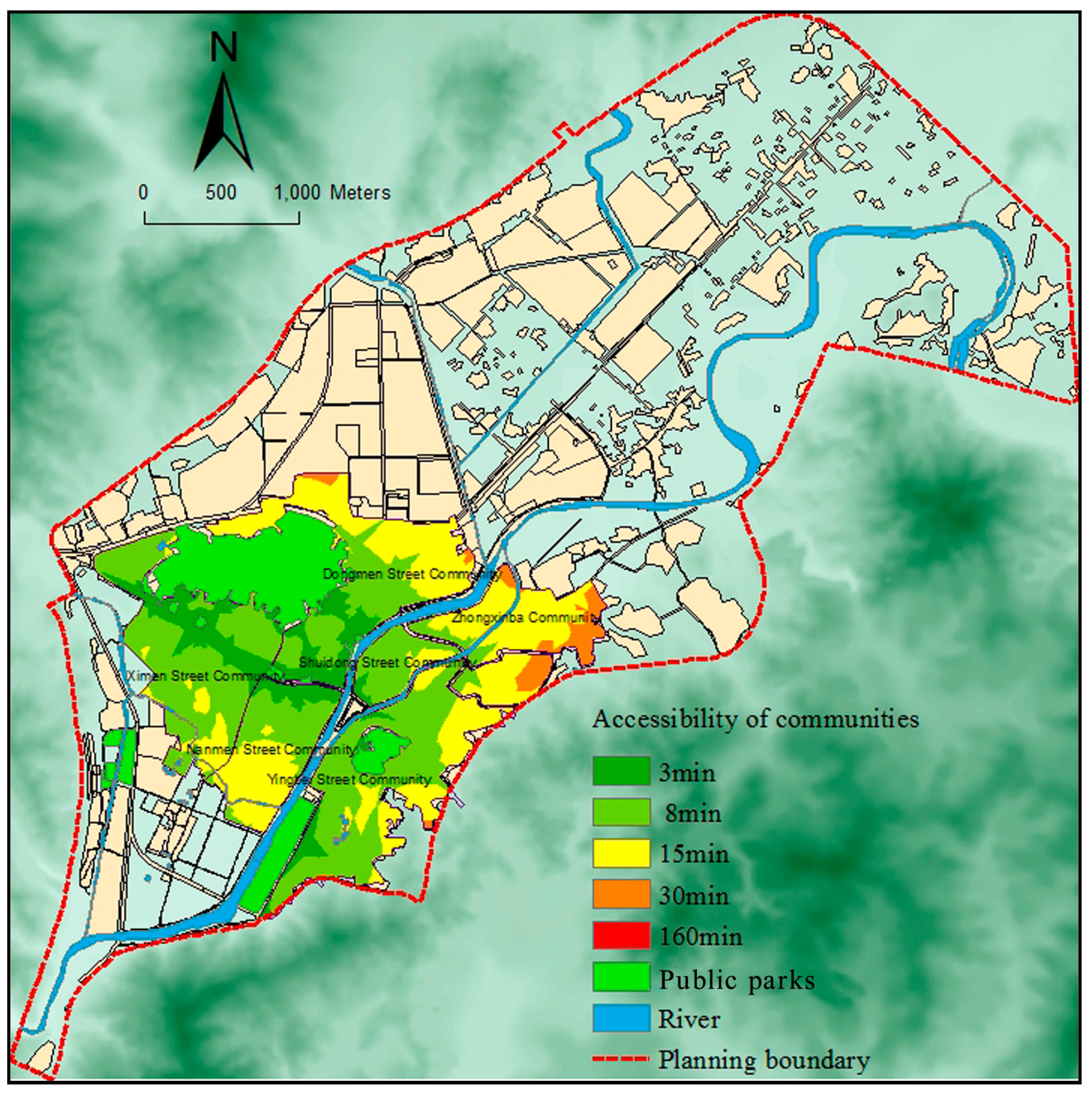
First, the results of the accessibility evaluation at the community scale show that urban parks’ accessibility levels are not high for Dongmen Street Community, Shuidong Street Community where historical and cultural blocks are located, and the high-density Zhongxinba Community.
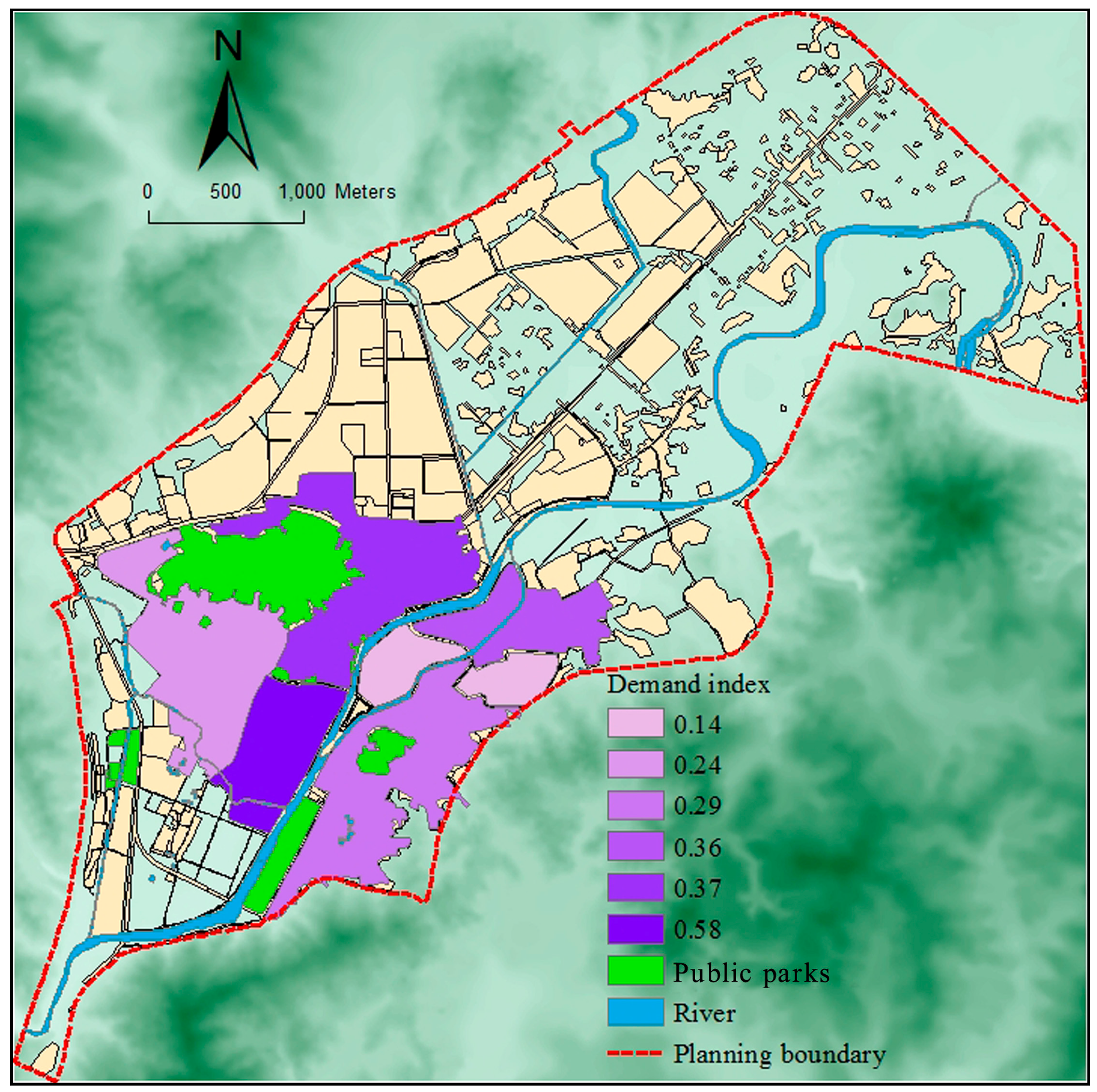
Second, according to the SDI results, the lowest value is found in Shuidong Street Community (0.14), while the highest value is found in Nanmen Street Community (0.58). This shows that there are obvious spatial differentiations between the distribution equity levels of the existing urban parks.
Third, according to the spatial overlay analysis, results indicate that the spatial distribution of urban parks is not equitable in terms of accessibility or residents’ demands. As a result, we can suggest an optimum SDI value of 0.3~0.4 and an AI value of 0.6~0.8 for the urban green space system planning for the future in the case study area.
The inequity is mainly affected by three factors. First, the implementation of ideas of people-orientation and social equity are not enough—vulnerable groups are still ignored by the social mainstream. Second, the development of urban real estate intensifies the differentiation of residential space, the residence of vulnerable groups mostly deviates from urban parks. Third, the aggregate supply of urban parks is insufficient and its spatial layout is unbalanced. There are significant differences of accessibility level in communities located in different areas in the study area. Thus, it fundamentally affects the equity degree for vulnerable groups sharing urban parks. Furthermore, on the basis of these data, we can increase the supply of green spaces and then establish an optimal urban park system according to accessibility and social equity.
In the recent ecological province construction of Fujian and with the recent goal of developing a provincial Garden County, Changting as the pilot county of ecological civilization construction demonstrates that its green space system planning should focus on both quantity and quality, as well as on the spatial distribution of urban parks. To obtain a more equitable and reasonable spatial distribution of urban parks, in addition to increasing urban green space resources and guiding the development of mixed land use, we still need to consider the equal distribution of green space resources and maximize the benefit of green space. In short, when planning an urban green space system, we should consider the equity evaluation and adaptively plan urban parks in the communities with a lower accessibility index, including Dongmen Street Community, Shuidong Street Community and Zhongxinba Community, to meet the demands of residents from all socio-economic backgrounds, and to ensure that residents enjoy this social service equally.
In the master plan for Changting (2010–2030), the goal of per capita green space is 13m2. Because of high population density and high load of parks in the old town of Changting, and the lack of street green space, the way of “see seam insert green space” should be adopted to increase small pieces of green space as soon as possible, in order to relieve pressure on parks. To realize the ecological benefits of such spaces, green corridors along Tingjiang River and Xihe Stream are recommended to increase connectivity among urban parks. In the case of road traffic, sub-level roads should be denser and greenways should be used to connect in series with major public parks to create better slow-moving conditions to improve accessibility. In addition, protective greenbelts can be updated to become public parks in conditional areas—even a small street green space can remedy the problem of unbalanced distribution. Using this strategy, the balance and equity distribution of urban public parks will be further improved, and still the urban green space system may be comprehensively improved from the angle of the integration of points, lines and surfaces.
Although there are important discoveries revealed by the study, there are also limitations. First, the eight indexes we selected not only reflect the social structure characteristics of the population and also indirectly describe the structural economic characteristics of the population, there still exist limitations that the details of the demand index are not comprehensive enough to fully express all the characteristics of socially vulnerable groups. Second, accessibility is only measured with respect to the associated time cost required to reach parks but does not involve material costs (such as money). Third, errors are generated from the cost-weighted distance method. In the process of calculation and analysis, the relative resistance values for roads, mountains, water systems and others are artificial assignments, so there exists a certain subjectivity. And much land area with the exception of urban roadways and rivers is occupied by buildings—actual paths refer to both urban roadways and community walking paths. Third, other attributes of urban parks such as park tickets, size, and facilities are not considered. Fourth, as this paper is restricted by the smallest statistical unit of the census data, and the measure of spatial equity is at the community level, the precision of the research is reduced. Further, the geographic unit of analysis is large, aggregated units; therefore it was impossible to accurately identify neighborhoods with a high percentage of vulnerable groups and calculate their access to parks. In addition, the findings were inconclusive due to the small number of observations. The factors described above will influence the accuracy of accessibility evaluation to some extent. Therefore, accessibility evaluation may be further improved by including such considerations to obtain more scientific and accurate research results.


