1. Introduction
Terrestrial vegetation plays a crucial role in controlling catchment water balance. Studying the impact of vegetation cover change on streamflow can help water resource managers to develop sustainable management strategies. Vegetation modulates and sustains evapotranspiration (ET) and precipitation (P). Without vegetation, the terrestrial water cycle would be much slower because of smaller ET losses and lower precipitation rates. Land regions lose their rainwater input either as ET or as surface and groundwater runoff [
1]. The amount of water that the ground absorbs also will depend on the land cover. Vegetation impacts the speed of water that will move across a surface. More vegetation leads to slower flowing water. Arid and semi-arid regions cover 41% of the Earth's land surface and contain 38% of the human population [
2]. These regions are more ecologically vulnerable and sensitive to climate change and human activities. It is a critical challenge to achieve and maintain ecosystem health in these regions [
3]. Understanding the connection between vegetation degradation and hydrological processes under global climate change is essential for quantifying the likely consequences of climate change and human activities on grassland ecosystems and achieving long-term grassland ecosystem sustainability in semi-arid watersheds.
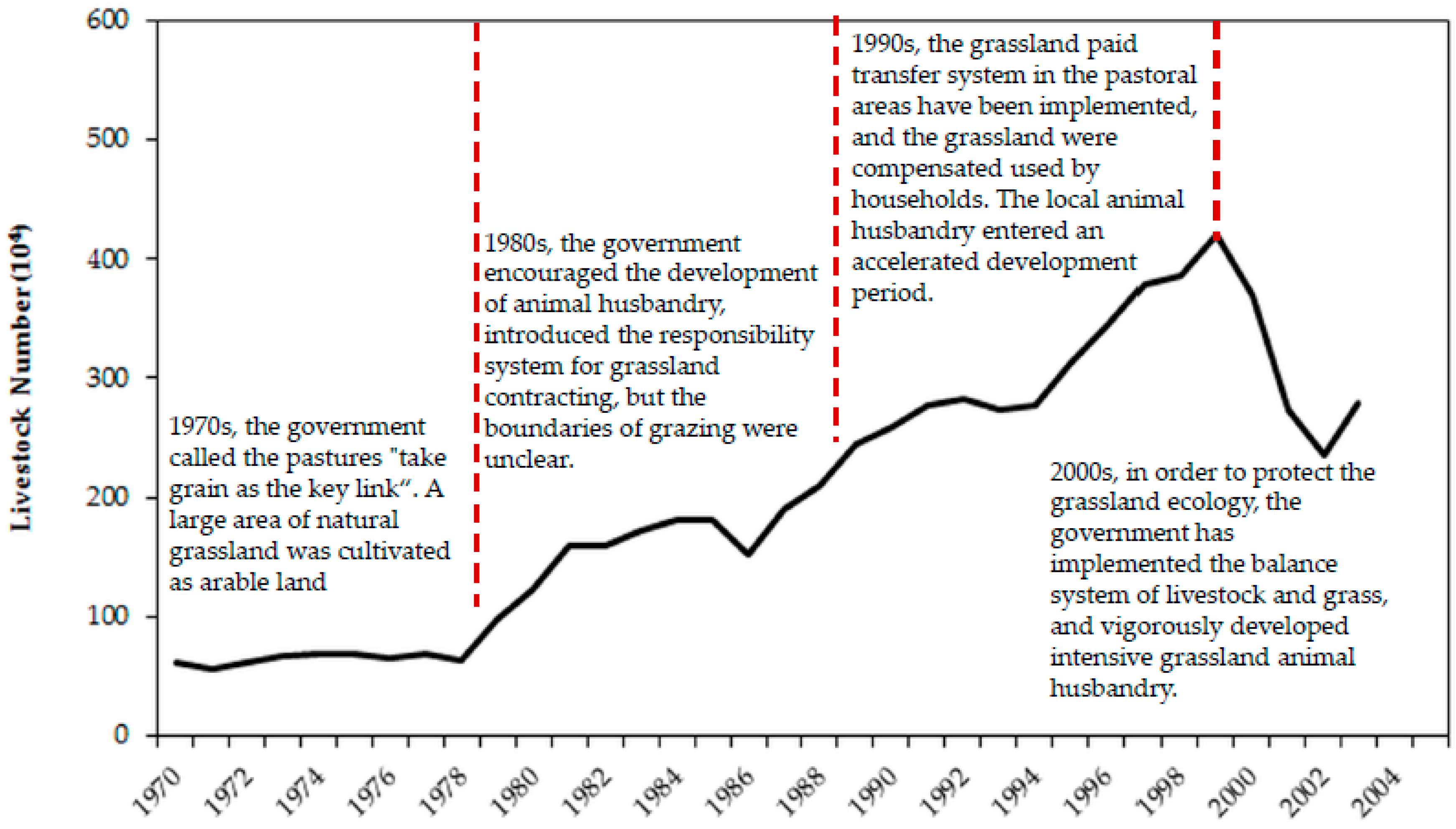
Overgrazing and land cover changes often lead to natural grassland ecosystem deterioration and degradation of catchments in arid and semi-arid regions [
4,
5,
6]. In the Inner Mongolian Plateau of China, land cover change and grassland overgrazing have been recognized as the key causes for the declines of grassland cover and quality, loss of biological diversity and degradation of ecosystem functions [
7,
8]. Vegetation degradation due to overgrazing and land cover changes affects various hydrological processes, such as interception, infiltration and ET, thereby influencing runoff generation. However, the impacts of vegetation changes on hydrological processes vary in space and time. Little is known in many catchments about the effects of specific land cover types on runoff production, streamflow and water balance closure [
9].
Numerous studies have attempted to evaluate the hydrological effects of vegetation dynamics and land cover changes using different methods, such as observation experiments [
10], remote sensing products and a statistic-based model [
11]. Li et al. [
12] investigated the underlying causes of satellite-derived vegetation change and subsequent impacts on runoff in the Northern Shaanxi Loess Plateau. Zhang et al. [
13] established a relationship between the change in the landscape parameter and vegetation change using the Budyko equation and quantified the impact of vegetation change on the regional hydrological cycle. However, traditional field experiments are generally constrained to the field scale, and the site level studies may be sensitive to the specific climatic and soil condition [
14]. Remote sensing products have some limitations to distinguish vegetation cover classes in arid and semi-arid areas due to their poor and scattered vegetation cover [
15]. The physically-based distributed ecohydrological model provided mechanistic and quantitative tools to investigate the connection between vegetation degradation and changes in hydrological processes under global climate change. The Soil and Water Assessment Tool (SWAT) [
16] is such a model that utilizes a plant growth module to simulate many types of land cover [
17]. As a process-based model, SWAT can be extrapolated to a broad range of conditions that may have limited observations. Therefore, it is widely used to study the impacts of environmental change for a wide range of scales and environmental conditions across the globe [
17,
18,
19].
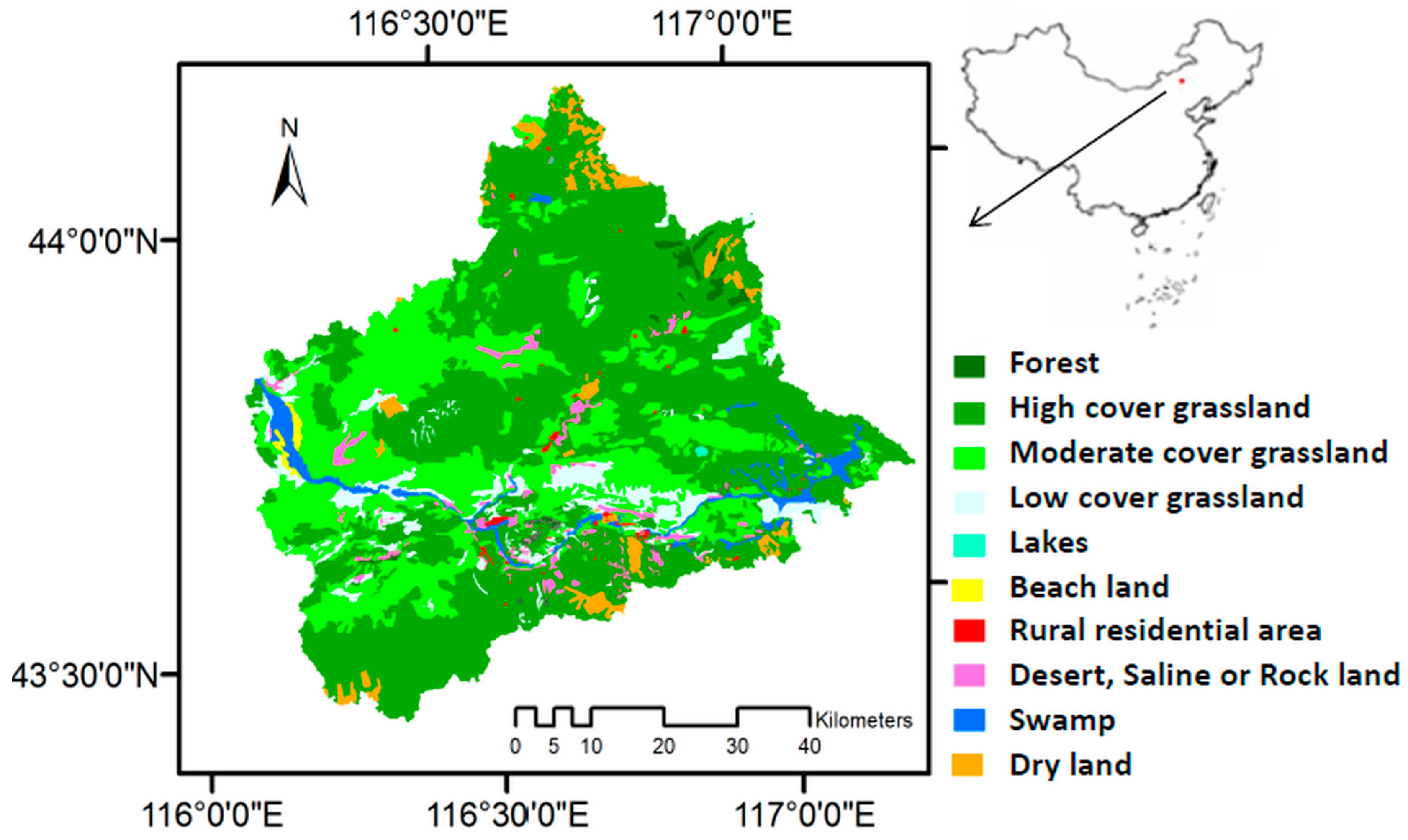
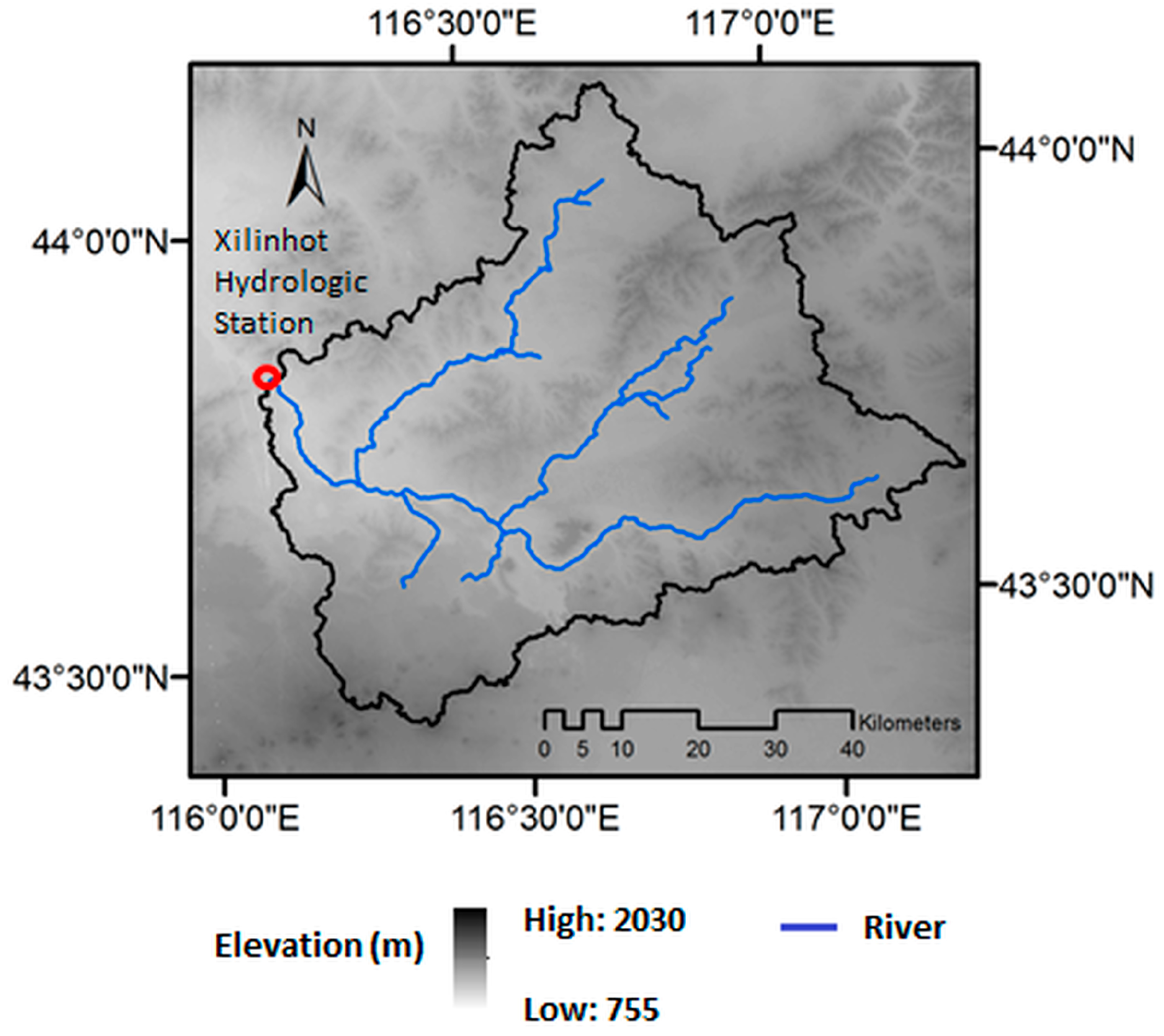
The Xilin River Basin (XLRB) is one of the few well-preserved areas of the Inner Mongolia grassland in northern China. This region has uneven distributions of both water and heat and, thus, large variations in primary productivity and hydrologic regimes [
8]. The runoff yield mechanism in the inland river basin is complex, especially for those basins, such as the XLRB, located in semi-arid regions [
20]. During the past three decades, due to adverse environmental conditions and intensified human activities (e.g., overgrazing and coal mining), the grassland ecosystem in this region has suffered from severe deterioration [
11].
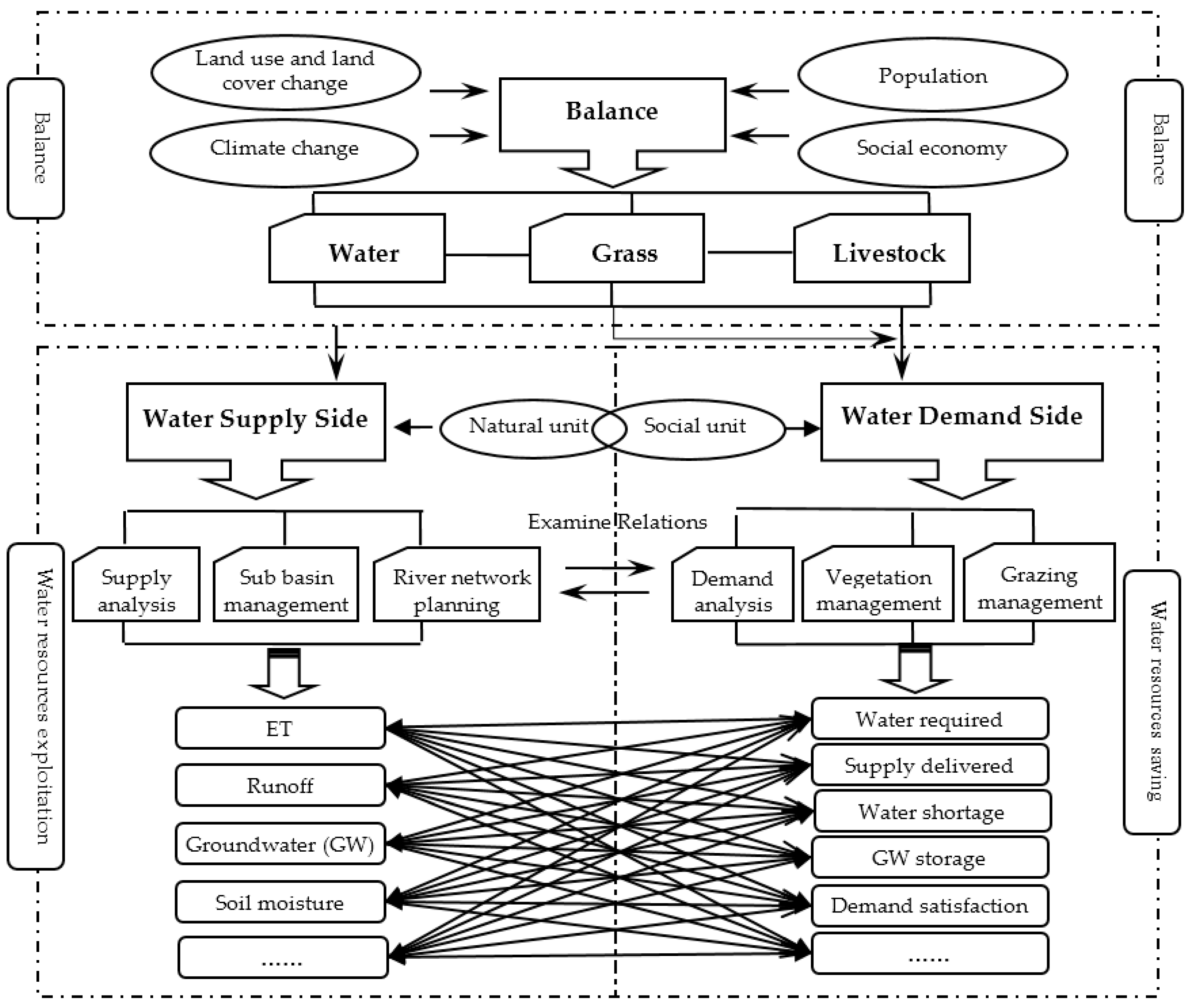
This study aimed at understanding the ecohydrological responses of a water-limited environment to climate changes and human activities using long-term ecohydrological simulation with the SWAT model. The specific objectives of this case study were to explore the following questions: (1) to setup and improve the SWAT model based on understanding the specific hydrological processes of the XLRB; (2) to simulate the consequences of vegetation cover on streamflow under multiple scenarios using improved SWAT; (3) to explore the relationships between vegetation cover and regional water balance. These objectives will be achieved by defining scenarios for changes in vegetation cover inputs to the SWAT model. The results contribute to the in-depth understanding of the mechanism of degradation and restoration of grassland ecosystem and regional biophysical and physiological processes under global climate change, as well as provide critical information to develop methods and strategies towards sustainable development in the study basin and beyond.
5. Conclusions
The vegetation cover changes due to climate change and human disturbances can change rangeland ecosystems considerably through altering the land use/cover patterns and ecosystem water balances between rainfall and ET [
4,
52]. Simulation method provides an effective and promising method that can support the understanding of dynamics, processes and the formation mechanism of environmental risk [
53,
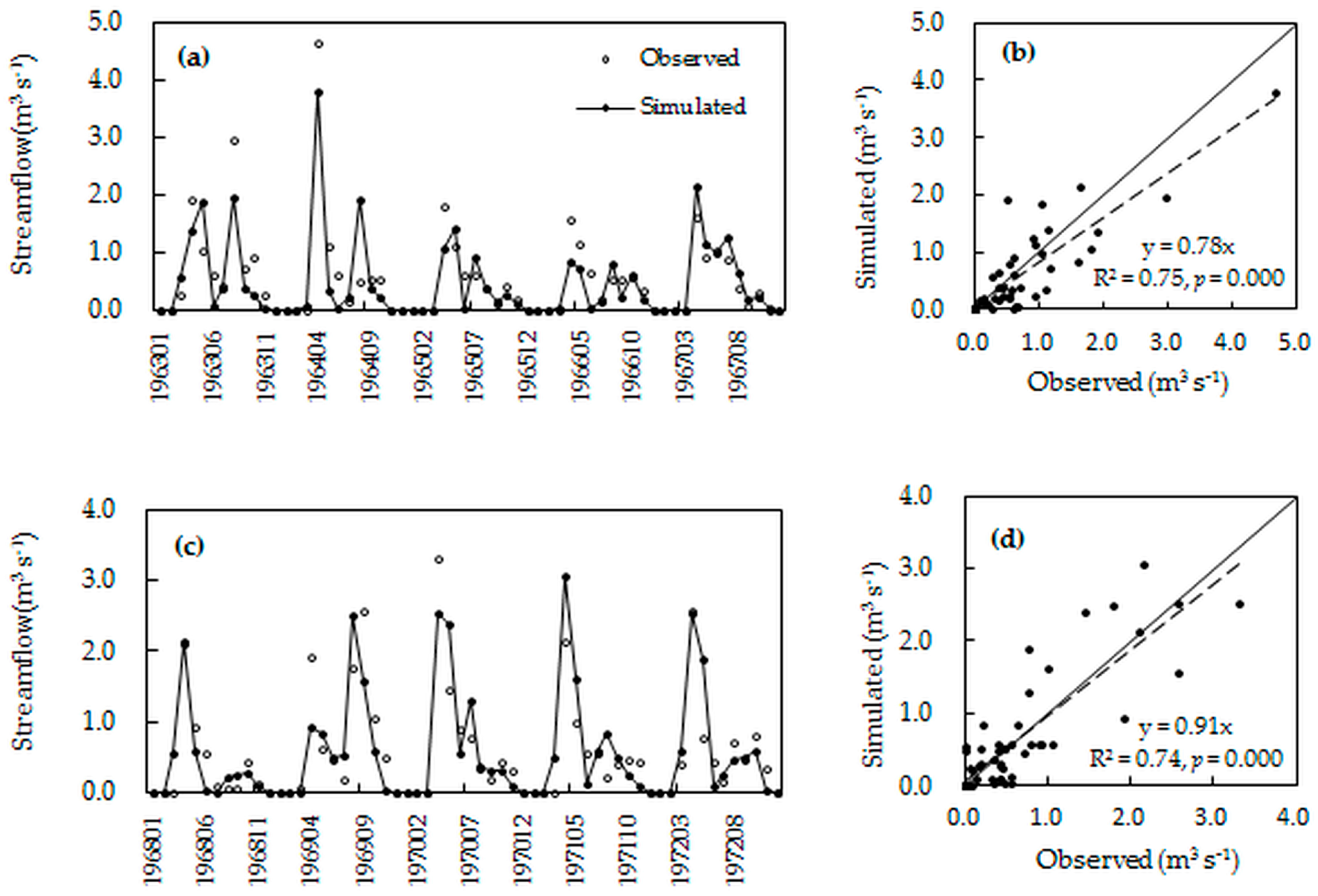
54]. This study offers an improved SWAT model to simulate the response of streamflow to vegetation cover change and climate variations under multiple scenarios and aims to understand the ecohydrological responses of a water-limited environment to climate changes and to human activities. The results showed that the improved SWAT model simulations matched well to measured monthly streamflow for both calibration periods with determination coefficient
R2 = 0.75 and Nash–Sutcliffe
ENS = 0.67, as well as validation periods with
R2 = 0.74 and
ENS = 0.68.
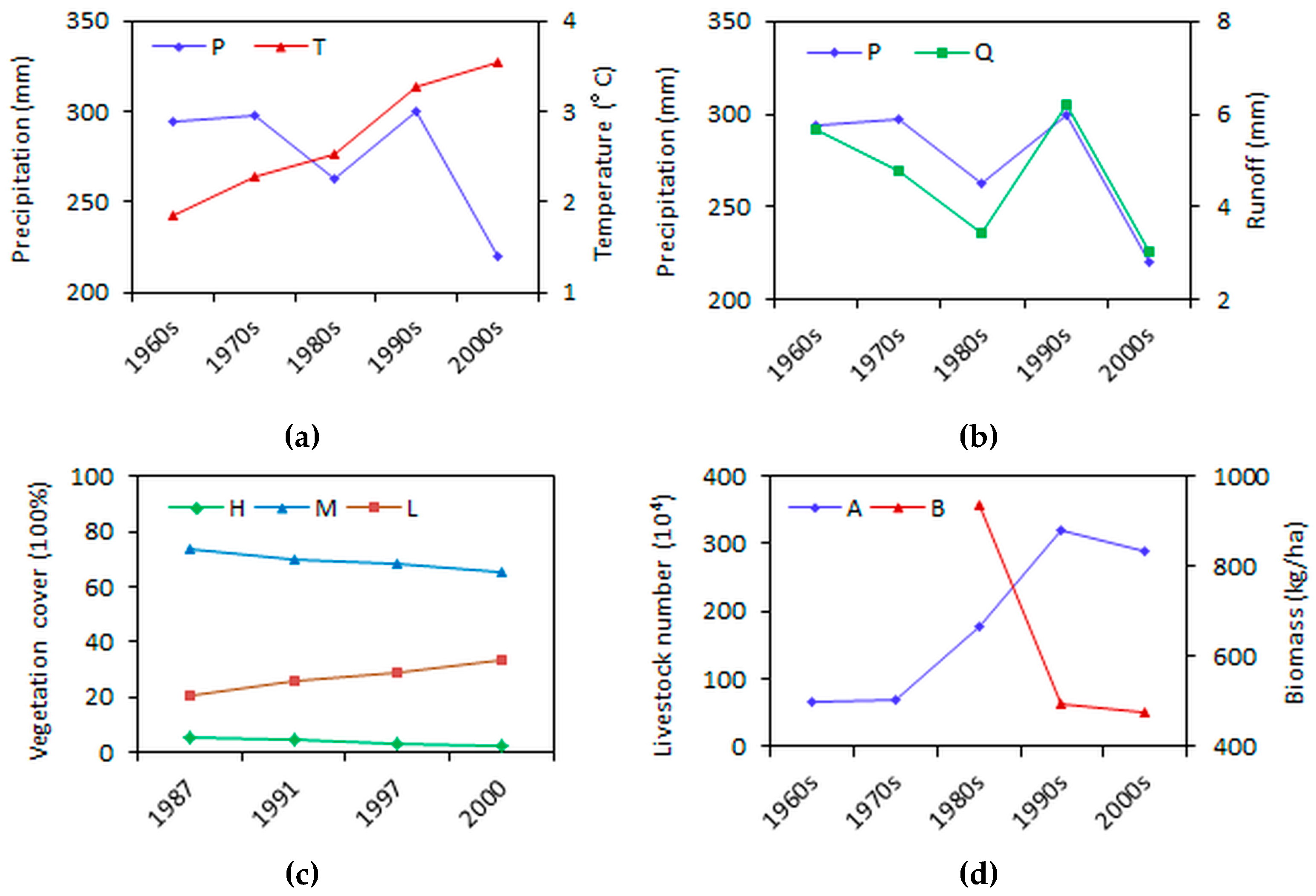
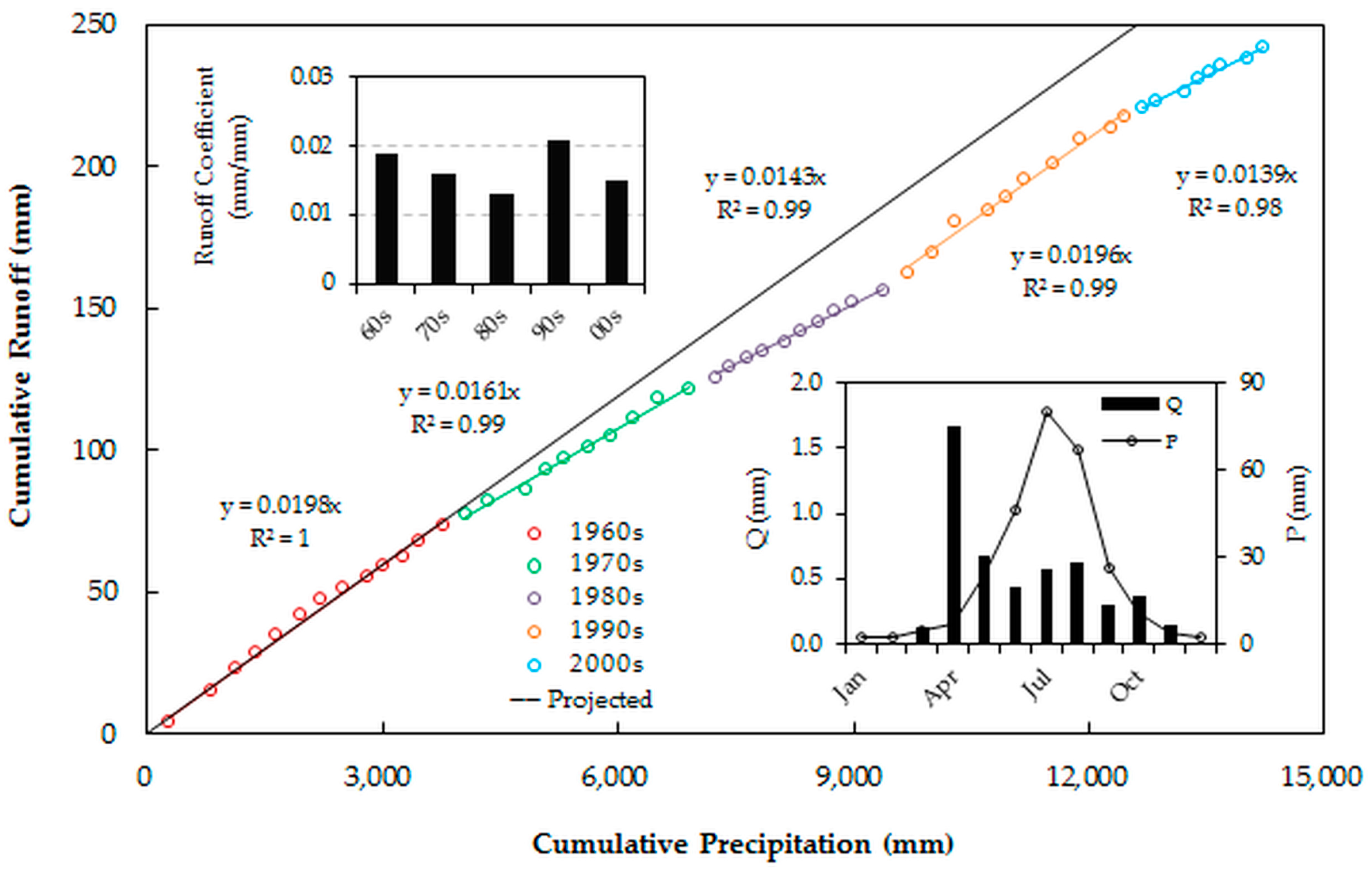
The simulating results indicated that precipitation dominated the water balances, and snow and permafrost melting in April dominated the annual river flow. The vegetation change scenario simulation results revealed that obvious changes occurred through conversion between high and low vegetation cover areas. The streamflow is sensitive to both climate variations and vegetation cover changes. The analysis suggests a clear association between streamflow change and precipitation variation, but also reveals that vegetation change may be an important factor. We also found the reductions in vegetation cover can elevate streamflow in both the rainfall season (July–August) and the snowmelt season (March–April), but the effects of the former are more obvious due to more vegetation cover in the rainfall season. These vegetation effects are more obvious during the periods with less rainfall or snowmelt. We conclude that in a particular climate zone, vegetation cover change is an important contributing factor to streamflow variations. Increases of streamflow in water-limited regions will likely reduce the effective water content of the soil, which in turn lead to further degradation of vegetation, particularly in the context of a drying and warming climate in this region.
Our study indicates that the ongoing large-scale degradation of vegetation due to overgrazing and other anthropogenic activities, such as mining and groundwater overuse, in the Xilin River Basin will likely change the hydrological environment and therefore increase the risk of ecological degradation and social vulnerability due to the loss of the ecosystem services of grassland vegetation. These findings highlight the importance of vegetation degradation on modifying the hydrological partitioning in the semi-arid steppe basin. The proposed relationship still needs to be evaluated in other catchments around the globe. The results contribute to the in-depth understanding of the mechanism of degradation and restoration of the grassland ecosystem and regional biophysical and physiological processes under global climate change, as well as provide critical information to develop methods and strategies towards sustainable development in the study basin and beyond.


