
Mapping and Monitoring the Akagera Wetland in Rwanda

 ,
,  , and
, and
Abstract
:1. Introduction
2. Materials and Methods
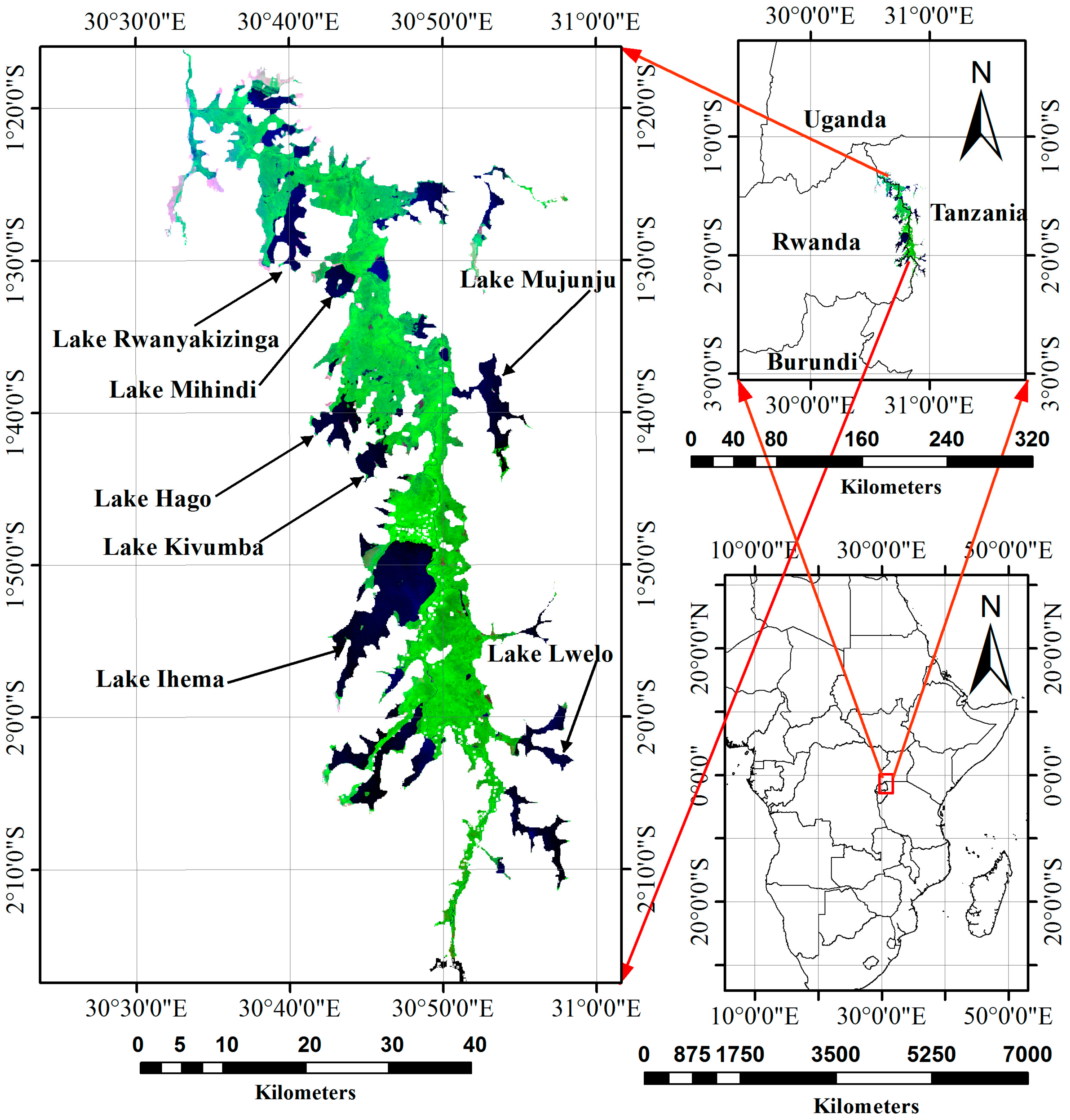
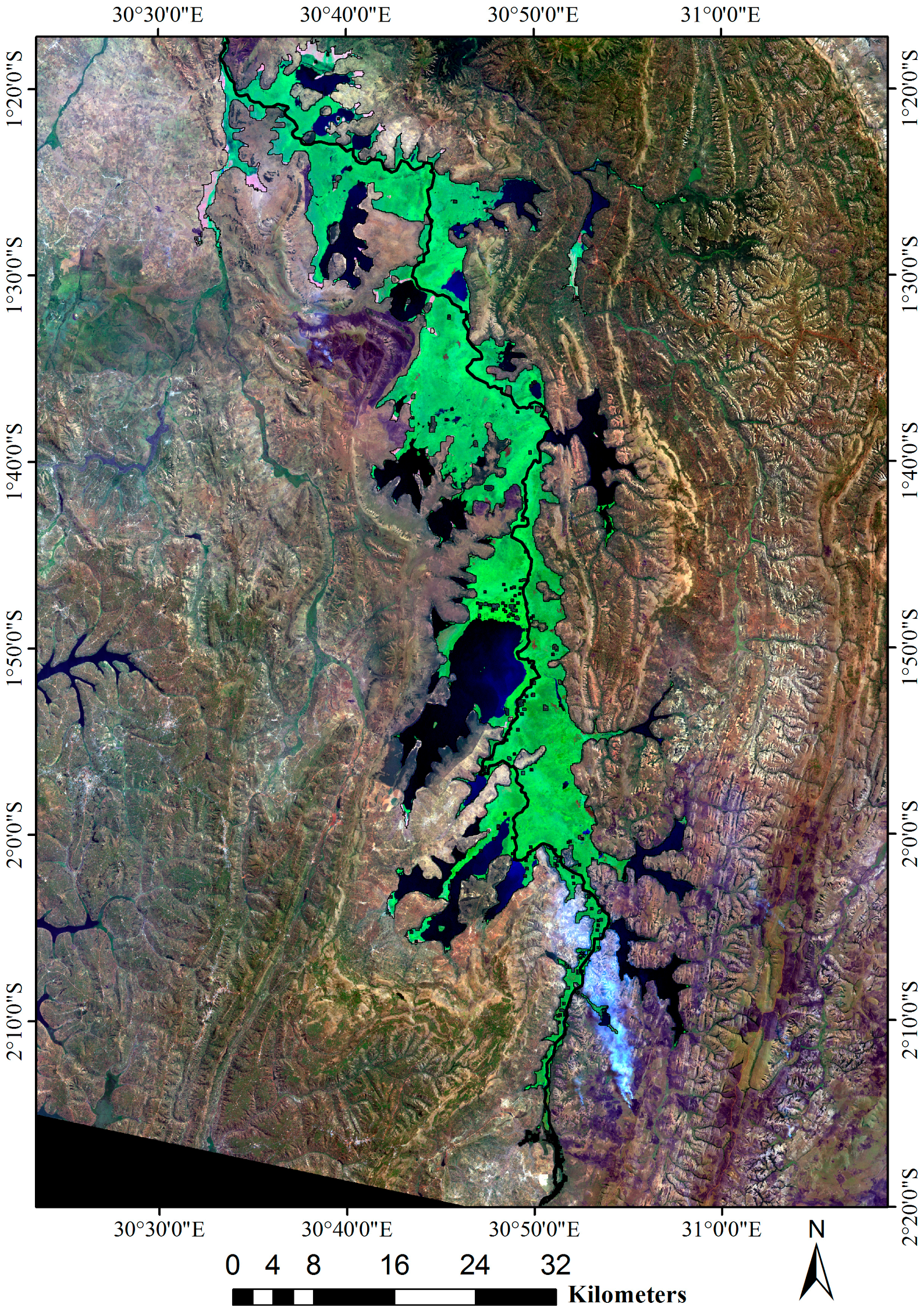
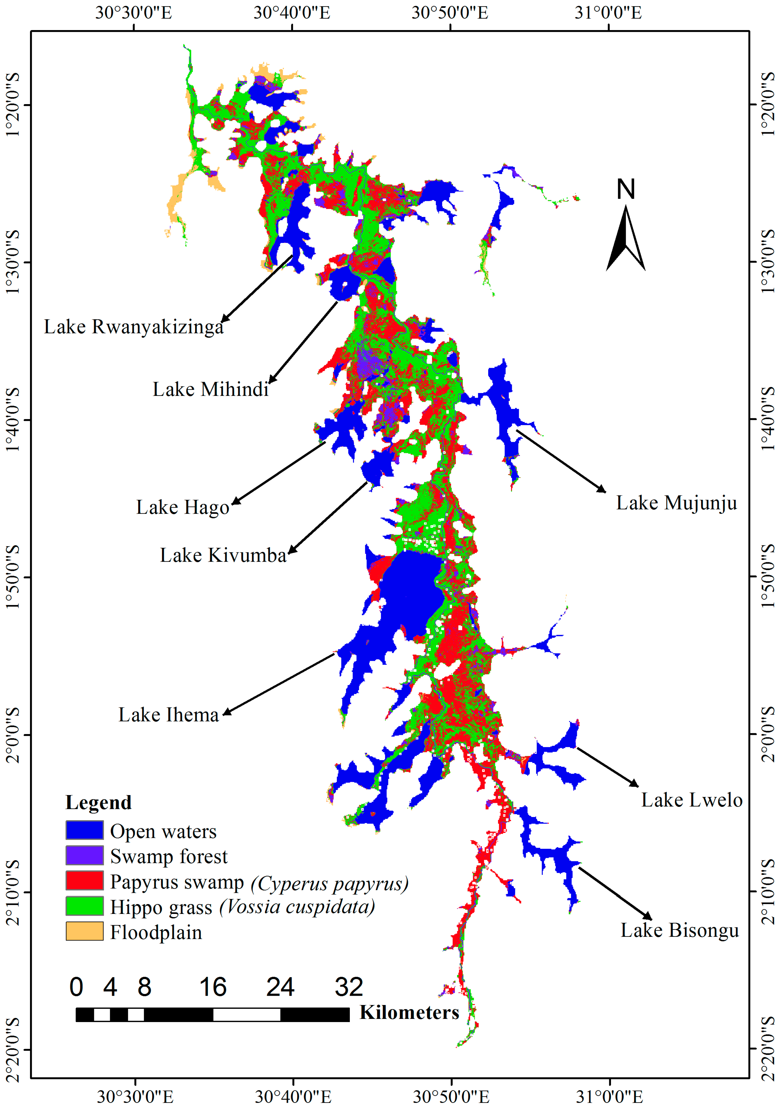
2.1. Study Area
2.2. Datasets
2.3. Methodology
2.3.1. Wetland Delineation
2.3.2. Landsat Image Pre-Processing
2.3.3. Image Processing and Analysis
3. Results
3.1. Delineation of the Wetland
3.2. Wetland Classification
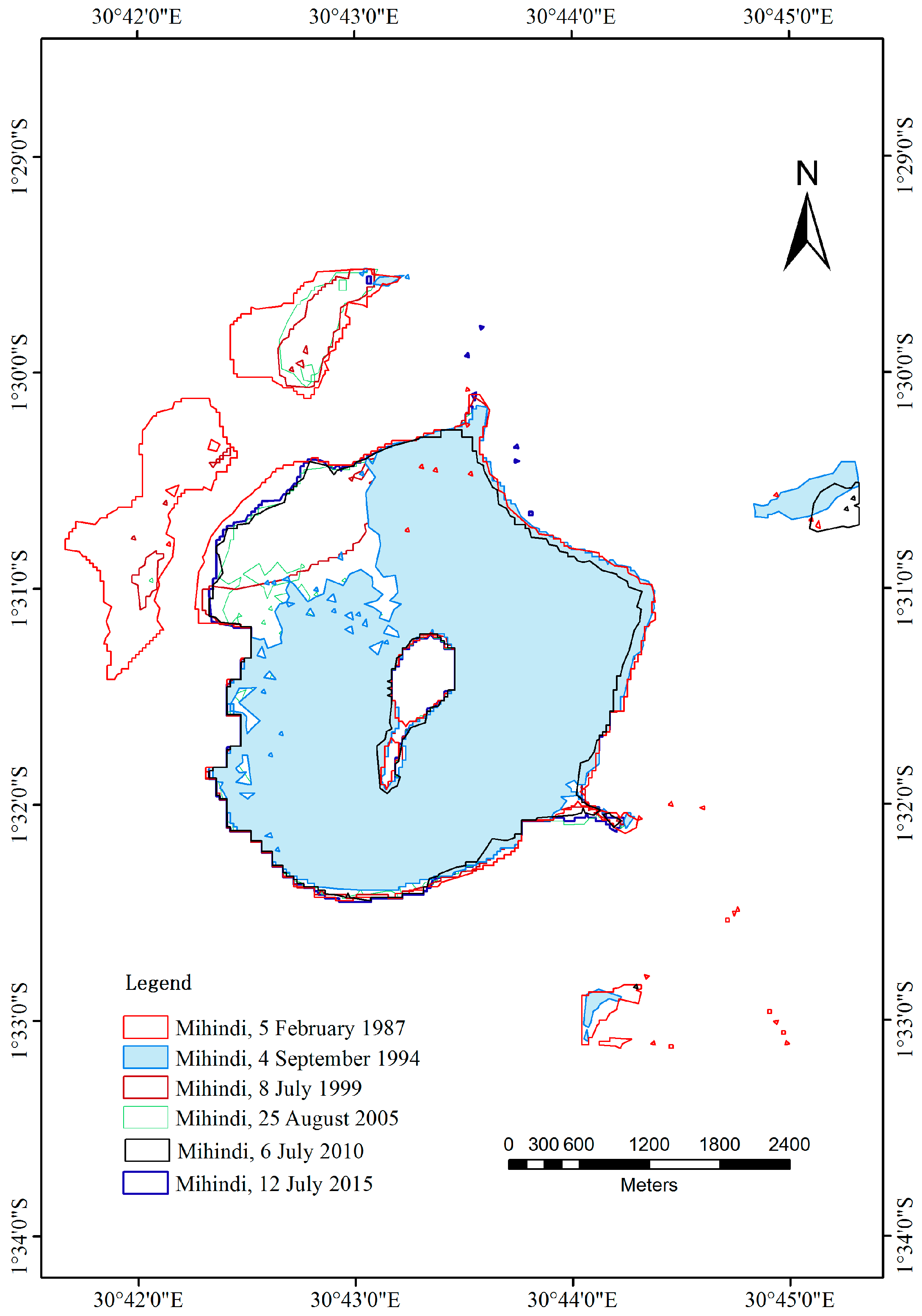
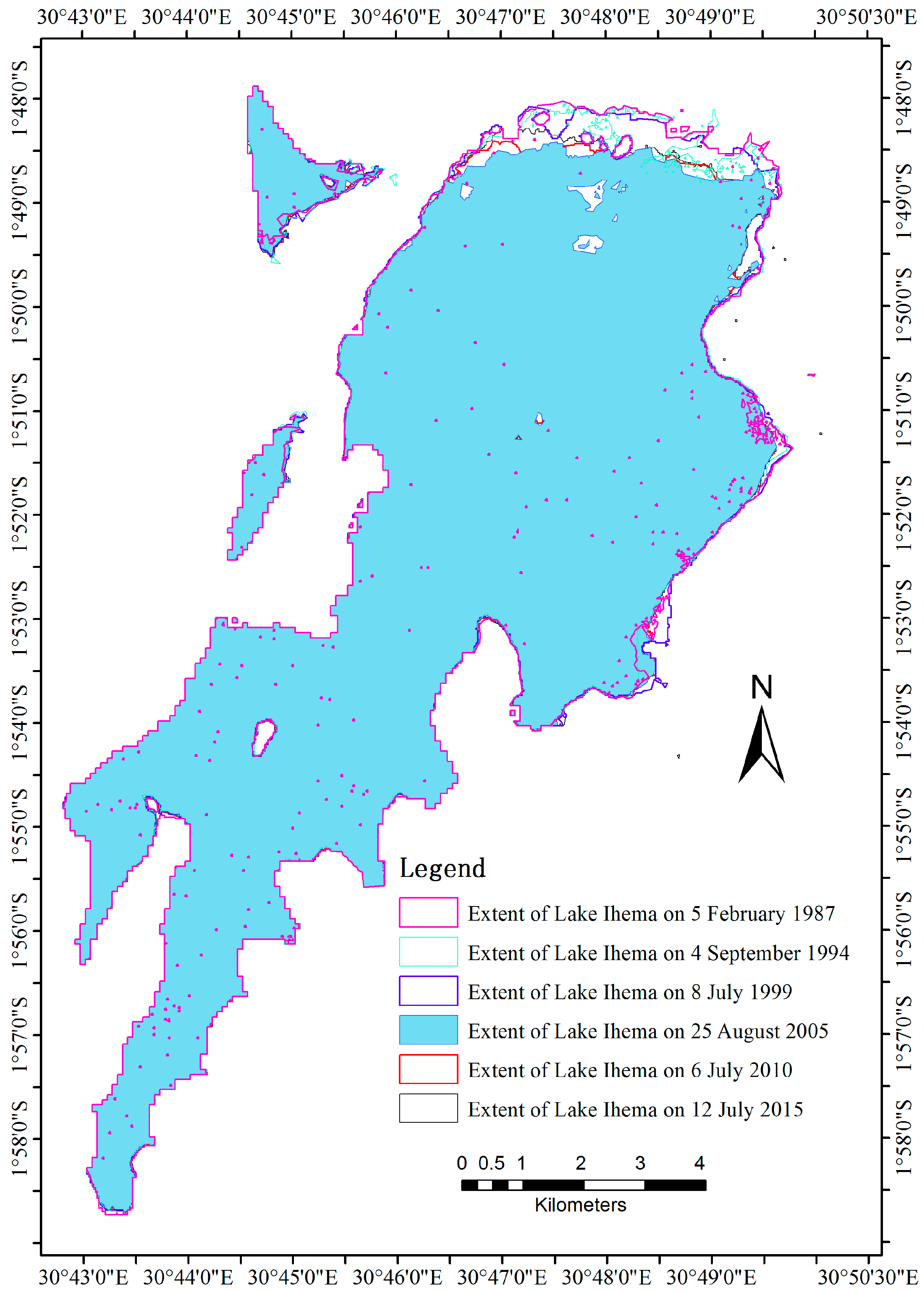
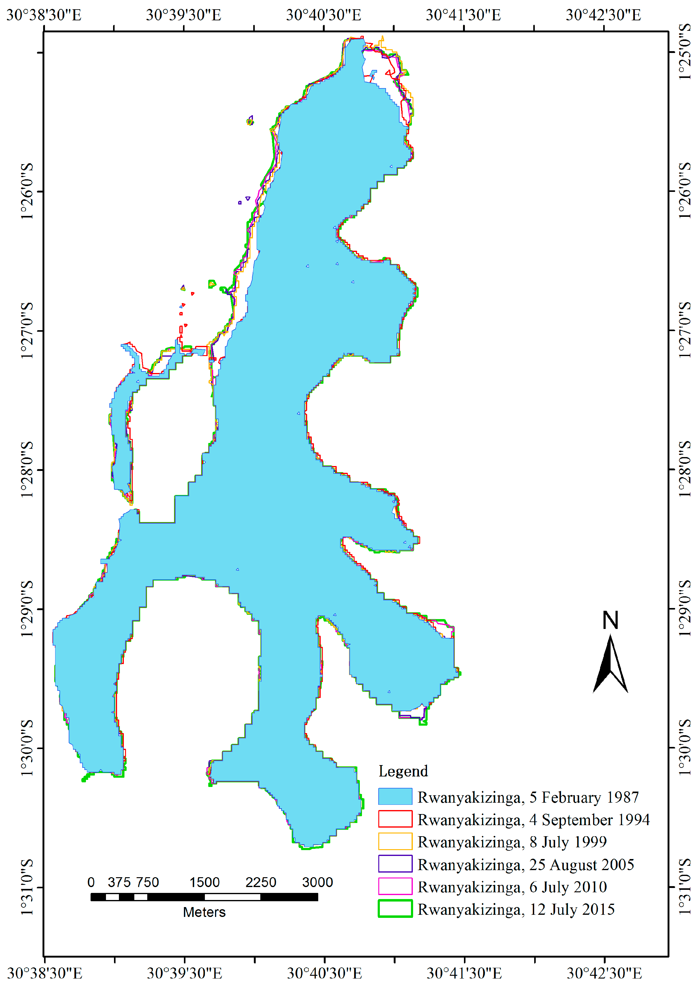
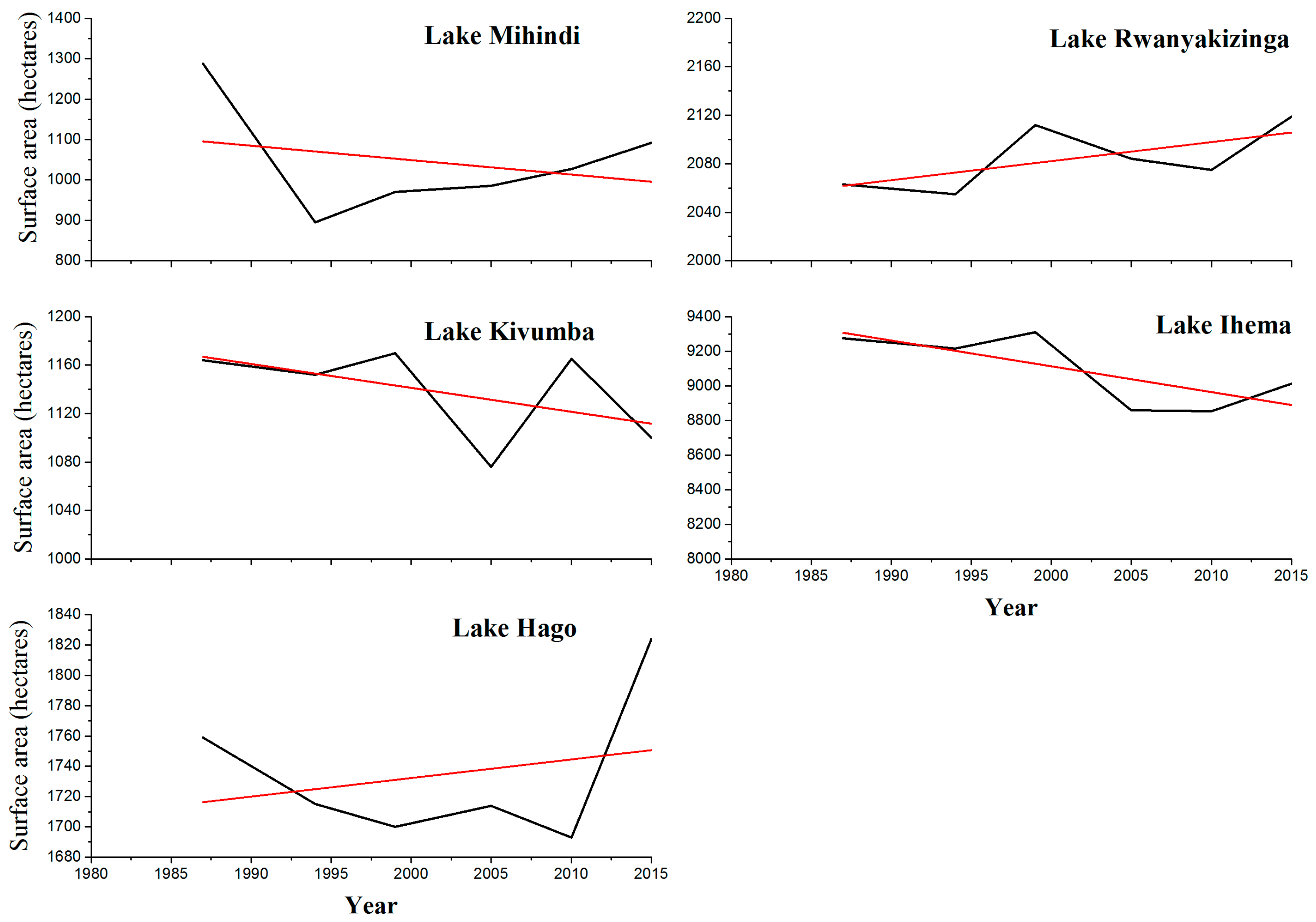
3.3. Selected Lakes’ Surface Water Extent Dynamics
4. Discussion
4.1. Wetland Demarcation and Classification
4.2. Lakes’ Surface Water Extent Dynamics
4.3. Uncertainties, Outlooks, and Prospects
5. Conclusions
Acknowledgments
Author Contributions
Conflicts of Interest
References
- Amler, E.; Schmidt, M.; Menz, G. Definitions and mapping of east African wetlands: A review. Remote Sens. 2015, 7, 5256–5282. [Google Scholar] [CrossRef]
- Odada, E.O.; Olago, D.O.; Kulindwa, K.; Ntiba, M.; Wandiga, S. Mitigation of environmental problems in Lake Victoria, east Africa: Causal chain and policy options analyses. Ambio J. Hum. Environ. 2004, 33, 13–23. [Google Scholar] [CrossRef]
- Baldassarre, G.A.; Bolen, E.G.; Sayre, T.R. Waterfowl Ecology and Management; Krieger: Malabar, FL, USA, 2006. [Google Scholar]
- Gallant, A.L. The challenges of remote monitoring of wetlands. Remote Sens. 2015, 7, 10938–10950. [Google Scholar] [CrossRef]
- Akinyemiju, O.A. Invasion of Nigerian waters by water hyacinth. J. Aquat. Plant Manag. 1987, 25, 24–26. [Google Scholar]
- Taylor, A.R.D. Floating Water-Weeds in East Africa, in Control of Africa’s Floating Water Weed; Commonwealth Science Council: Harare, Zimbabwe, 1991; pp. 111–124.
- Albright, T.P.; Moorhouse, T.G.; Mcnabb, T.J. The rise and fall of water hyacinth in Lake Victoria and the Kagera river basin, 1989–2001. J. Aquat. Plant Manag. 2004, 42, 73–84. [Google Scholar]
- Ozesmi, S.L.; Bauer, M.E. Satellite remote sensing of wetlands. Wetl. Ecol. Manag. 2002, 10, 381–402. [Google Scholar] [CrossRef]
- Nyandwi, E.; Veldkamp, A.; Amer, S. Delineating Rwandan wetlands using topographic and climatic parameters. In Proceedings of the International Conference on Geospatial Technologies for Sustainable Urban and Rural Development (GeoTechRwanda 2015), Kigali, Rwanda, 18–20 November 2015.
- Dahl, T.E. Remote sensing as a tool for monitoring wetland habitat change. In Proceedings of the Monitoring Science and Technology Symposium: Unifying Knowledge for Sustainability in the Western Hemisphere, Denver, CO, USA, 20–24 September 2006.
- Davidson, N.C.; Finlayson, C.M. Earth observation for wetland inventory, assessment and monitoring. Aquat. Conserv. Mar. Freshw. Ecosyst. 2007, 17, 219–228. [Google Scholar] [CrossRef]
- Mwita, E.; Menz, G.; Misana, S.; Nienkemper, P. Detection of small wetlands with multi sensor data in east Africa. Adv. Remote Sens. 2012, 1, 26107. [Google Scholar] [CrossRef]
- Fuller, R.; Groom, G.; Mugisha, S.; Ipulet, P.; Pomeroy, D.; Katende, A.; Bailey, R.; Ogutu-Ohwayo, R. The integration of field survey and remote sensing for biodiversity assessment: A case study in the tropical forests and wetlands of Sango bay, Uganda. Biol. Conserv. 1998, 86, 379–391. [Google Scholar] [CrossRef]
- Fischer, E.; Dumbo, B. Biodiversity Inventory for Key Wetlands in Rwanda; Rwanda Environment Management Authority: Kigali, Rwanda, 2011.
- Ndayisaba, F. Understanding the spatial temporal vegetation dynamics in Rwanda. Remote Sens. 2016, 8, 129. [Google Scholar] [CrossRef]
- Kulawardhana, R.; Thenkabail, P.; Vithanage, J.; Biradar, C.; Islam, M.A.; Gunasinghe, S.; Alankara, R. Evaluation of the wetland mapping methods using Landsat ETM+ and SRTM data. J. Spat. Hydrol. 2007, 7, 62–96. [Google Scholar]
- Montgomery, D.R. Slope distributions, threshold hillslopes, and steady-state topography. Am. J. Sci. 2001, 301, 432–454. [Google Scholar] [CrossRef]
- Mwita, E.; Menz, G.; Misana, S.; Becker, M.; Kisanga, D.; Boehme, B. Mapping small wetlands of Kenya and Tanzania using remote sensing techniques. Int. J. Appl. Earth Obs. Geoinf. 2013, 21, 173–183. [Google Scholar] [CrossRef]
- Nyandwi, E.; Veldkamp, T.; Amer, S. Regional climate sensitivity of wetland environments in Rwanda: The need for a location-specific approach. Reg. Environ. Chang. 2016, 16, 1635–1647. [Google Scholar] [CrossRef]
- Li, W.C.J. A rule-based method for mapping Canada’s wetlands using optical, radar and DEM data. Int. J. Remote Sens. 2005, 26, 5051–5069. [Google Scholar] [CrossRef]
- Song, C.; Woodcock, C.E.; Seto, K.C.; Lenney, M.P.; Macomber, S.A. Classification and change detection using landsat TM data: When and how to correct atmospheric effects. Remote Sens. Environ. 2001, 75, 230–244. [Google Scholar] [CrossRef]
- Li, W.; Du, Z.; Ling, F.; Zhou, D.; Wang, H.; Gui, Y.; Sun, B.; Zhang, X. A comparison of land surface water mapping using the Normalized Difference Water Index from TM, ETM+ and ALI. Remote Sens. 2013, 5, 5530–5549. [Google Scholar] [CrossRef]
- Houhoull, P.F. Detecting wetland change: A rule-based approach using NWI and SPOT-XS data. Photogramm. Eng. Remote Sens. 2000, 66, 205–211. [Google Scholar]
- Kayiranga, A.; Kurban, A.; Ndayisaba, F.; Nahayo, L.; Karamage, F.; Ablekim, A.; Ilniyaz, O. Monitoring forest cover change and fragmentation using remote sensing and landscape metrics in Nyungwe-Kibira park. J. Geosci. Environ. Prot. 2016, 4, 13. [Google Scholar] [CrossRef]
- Davranche, A.L.G.; Poulin, B. Wetland monitoring using classification trees and SPOT-5 seasonal time series. Remote Sens. Environ 2010, 114, 552–562. [Google Scholar] [CrossRef] [Green Version]
- Du, Z.; Linghu, B.; Ling, F.; Li, W.; Tian, W.; Wang, H.; Gui, Y.; Sun, B.; Zhang, X. Estimating surface water area changes using time-series Landsat data in the Qingjiang river basin, China. J. Appl. Remote Sens. 2012, 6, 063609. [Google Scholar] [CrossRef]
- Giardino, C.; Bresciani, M.; Villa, P.; Martinelli, A. Application of remote sensing in water resource management: The case study of Lake Trasimeno, Italy. Water Resour. Manag. 2010, 24, 3885–3899. [Google Scholar] [CrossRef]
- Moorhouse, T.M.; Agaba, P.; Mcnabb, T.J. Recent efforts in biological control of water hyacinth in the Kagera river headwaters of Rwanda. In Proceedings of the ACIAR, Nile International Conference, Lae, Papua New Guinea, 26–30 June 2000.
- Almendinger, J.E. Ground water control of closed-basin Lake levels under steady-state conditions. J. Hydrol. 1990, 112, 293–318. [Google Scholar] [CrossRef]
- Soussa, H.; Azab, A.; Kashaigili, J.J.; Oyo, R. Analyitical Tools for Wetlands Management in the Nile Basin; Nile Basin Capacity Building Network: Cairo, Egypt, 2010. [Google Scholar]
- Lemm, B. Ecological changes in two Ethiopian Lakes caused by contrasting human intervention. Limnologica 2003, 33, 44–53. [Google Scholar] [CrossRef]
- Arsen, A.; Abarca-del-Rio, R.; Crétaux, J.-F. Remote sensing-derived bathymetry of Lake Poopó. Remote Sens. 2013, 407–420. [Google Scholar] [CrossRef]
- Birkett, C.M. Synergistic remote sensing of Lake Chad: Variability of basin inundation. Remote Sens. Environ. 2000, 72, 218–236. [Google Scholar] [CrossRef]
- Tulbure, M.G.; Kininmonth, S.; Broich, M. Spatiotemporal dynamics of surface water networks across a global biodiversity hotspot—Implications for conservation. Environ. Res. Lett. 2014, 9, 114012. [Google Scholar] [CrossRef]
- United States Environmental Protection Agency (UNEP). Wetlands Monitoring and Assessment. Available online: https://www.epa.gov/wetlands/what-are-wetland-functions (accessed on 8 April 2016).
- Spiers, C.F.A. Global Review of Wetland Resources and Priorities for Wetland Inventory; Wetlands International: Canberra, Australia, 1999. [Google Scholar]


| Sensor | Scene ID | Path & Row | Acquisition Date |
|---|---|---|---|
| Landsat 5 TM | LT51720611987036 | Path 172, row 61 | 5 February 1987 |
| Landsat 5TM | LT51720611994247 | Path 172, row 61 | 4 September 1994 |
| Landsat 7 ETM+ SLC on | LE71720611999189 | Path 172, row 61 | 8 July 1999 |
| Landsat 7 ETM+ SLC off | LE71720612005237 | Path 172, row 61 | 25 August 2005 |
| Landsat 7 ETM+ SLC off | LE71720612010187 | Path 172, row 61 | 6 July 2010 |
| Landsat 8 OLI | LC81720612015193 | Path 172, row 61 | 12 July 2015 |
| Class Name | User’s Accuracy | Producer’s Accuracy | Overall Accuracy |
|---|---|---|---|
| Water | 100% | 96.1% | 81.9% |
| Swamp Forest | 63.8% | 96.7% | |
| Papyrus Swamp | 81.6% | 64.5% | |
| Hippo grass | 80% | 75.4% | |
| Floodplain | 83.3% | 87.5% |
| 1987 | 1994 | 1999 | 2005 | 2010 | 2015 | |
|---|---|---|---|---|---|---|
| Hago | 1759 | 1715 | 1700 | 1714 | 1693 | 1824 |
| Ihema | 9275 | 9215 | 9310 | 8858 | 8855 | 9012 |
| Kivumba | 1164 | 1152 | 1170 | 1076 | 1165 | 1100 |
| Mihindi | 1287 | 895 | 970 | 985 | 1027 | 1092 |
| Rwanyakizinga | 2063 | 2055 | 2112 | 2084 | 2075 | 2147 |
© 2017 by the authors. Licensee MDPI, Basel, Switzerland. This article is an open access article distributed under the terms and conditions of the Creative Commons Attribution (CC BY) license ( http://creativecommons.org/licenses/by/4.0/).
Share and Cite
Ndayisaba, F.; Nahayo, L.; Guo, H.; Bao, A.; Kayiranga, A.; Karamage, F.; Nyesheja, E.M. Mapping and Monitoring the Akagera Wetland in Rwanda. Sustainability 2017, 9, 174. https://doi.org/10.3390/su9020174
Ndayisaba F, Nahayo L, Guo H, Bao A, Kayiranga A, Karamage F, Nyesheja EM. Mapping and Monitoring the Akagera Wetland in Rwanda. Sustainability. 2017; 9(2):174. https://doi.org/10.3390/su9020174
Chicago/Turabian StyleNdayisaba, Felix, Lamek Nahayo, Hao Guo, Anming Bao, Alphonse Kayiranga, Fidele Karamage, and Enan M. Nyesheja. 2017. "Mapping and Monitoring the Akagera Wetland in Rwanda" Sustainability 9, no. 2: 174. https://doi.org/10.3390/su9020174