Article

Impacts of Mining and Urbanization on the Qin-Ba Mountainous Environment, China

1
State Key Laboratory of Resources and Environmental Information Systems, Institute of Geographical Sciences and Natural Resources Research, Chinese Academy of Sciences, Beijing 100101, China
2
School of Marketing and Management, the University of Adelaide, Adelaide 5005, Australia
*
Author to whom correspondence should be addressed.
Sustainability 2016, 8(5), 488; https://doi.org/10.3390/su8050488
Submission received: 21 March 2016 / Revised: 12 May 2016 / Accepted: 13 May 2016 / Published: 18 May 2016
(This article belongs to the Section Sustainable Urban and Rural Development)

Abstract

:
The Qin-Ba Ecological Functional Zone is a component of China’s ecological security pattern designed to protect the regional ecosystem and maintain biodiversity. However, due to the impact of mining and urban encroachment, the plight of a sustainable ecosystem in the Qin-Ba mountainous area is deteriorating. This paper has used a remote sensing and geographic information system (GIS) to examine the impacts of mining and urban encroachment on the environment in the Qin-Ba mountainous area. The results indicate that the total mined area in 2013 was 22 km2 and is predicted to escalate. Results also show that the ecosystems in Fengxian County, Shaanxi Province and Baokang County, Hubei Province were most severely affected by mining. Urbanization in the Qin-Ba mountainous area has seen an increase of 85.58 km2 in urban land use from 2010 to 2013. In addition, infrastructure development including airport construction, tourism resorts and real estate development in the Qin-Ba mountainous area has intensified environmental and biodiversity disturbances since large areas of forest have been cleared. Our results should provide insight and assistance to city planners and government officials in making informed decisions.

1. Introduction

Human activities including land development ranging from farming, grazing, logging, infrastructure construction, nature conservation and utilization are affecting the environment and biodiversity [1,2]. Land development on the one hand promotes economic growth, improves urban infrastructure and provides accommodation to a growing urban population, etc. On the other hand, land development poses a risk to the ecological environment, such as degradation of land resources, deforestation and a decline in the biodiversity and increased pollution [3].
Since the adoption of an economic reform and open-door policy in 1978, China has experienced extensive land transformation characterized by massive urbanization, infrastructural development and farming which have resulted in environmental and biodiversity degradation [4,5,6]. Mining is one of the growing industries in the Qin-Ba mountainous area with economic and societal benefits, however, mining activities pose a major challenge to environmental sustainability [7,8]. Application of remote sensing and GIS to examine mining impacts has been proven to be effective at the regional level [9,10,11]. For example, the study of Malaviya et al. showed that continued mining practices have adverse impacts on the landscape and the ecosystem in central India [10]. Also, the study revealed that coal mining in Wuhai, China resulted in the degradation of the ecological environment from 1979 to 2010 [11]. A recent study also showed that the expansion of the coal mining fields impacted on the land cover types in the Mu Us Sandy Land in northern China [12].
Land development and utilization associated with economic growth has attracted extensive interest due to its negative impact on the ecosystem. Key issues associated with land development and urbanization are degradation and destruction of the ecological environment [13,14,15]. For example, Hassan and Nazem highlighted that rapid urban expansion of Chittagong, Bangladesh resulted in the reduction of croplands and vegetation cover, hill encroachment and other environmental problems [13]. Through an investigation and analysis of the land use in the economic development zones in Chongqing, Cao [16] discovered that “cutting mountains and filling rivers to build cities” extensively existed in most of the western cities. He also showed that such land development patterns can cause destruction of the environment and recommended that more attention be directed to environmental protection and reparation.
Qinling-Daba biodiversity ecological function area, also named “Qin-Ba mountainous area” is one of the 25 national key ecological function areas established in late 2010 by the central government of China for national environmental protection [17,18]. Providing ecological services to their surrounding regions are a top priority. Thus, hunting and harvesting activities in these regions have been banned. However, other development activities such as mining, tourism and urban development are allowed for the regional poverty alleviation and economic development. Among the key economic activities, mining and urbanization were identified as posing the severest threat to the regional environment. “Qin-Ba mountainous area” is an important part of China’s “two barriers and three zones” strategy for ecological security pattern. The area is designated to protect the ecosystem and maintain biodiversity. However, the intensified land development including mining, dam construction and urbanization in the Qin-Ba mountainous area has resulted in soil erosion, shrinking of vegetation coverage areas, damage to plants and animal habitat [17,19,20].
In this paper, remote sensing and GIS technologies were used to monitor the impact of two important land development activities: mining and urban expansion on the ecological environment in the Qin-Ba mountainous area from 2010 to 2013. This approach has been used in various studies including land use change analysis in the Zhujiang Delta of China [21,22]. It is anticipated that the findings of this study can contribute to city planners and government policymakers in reaching an informed decision. This will also benefit other stakeholders in developing proper land utilization and management plan for the area.

2. Materials and Methods
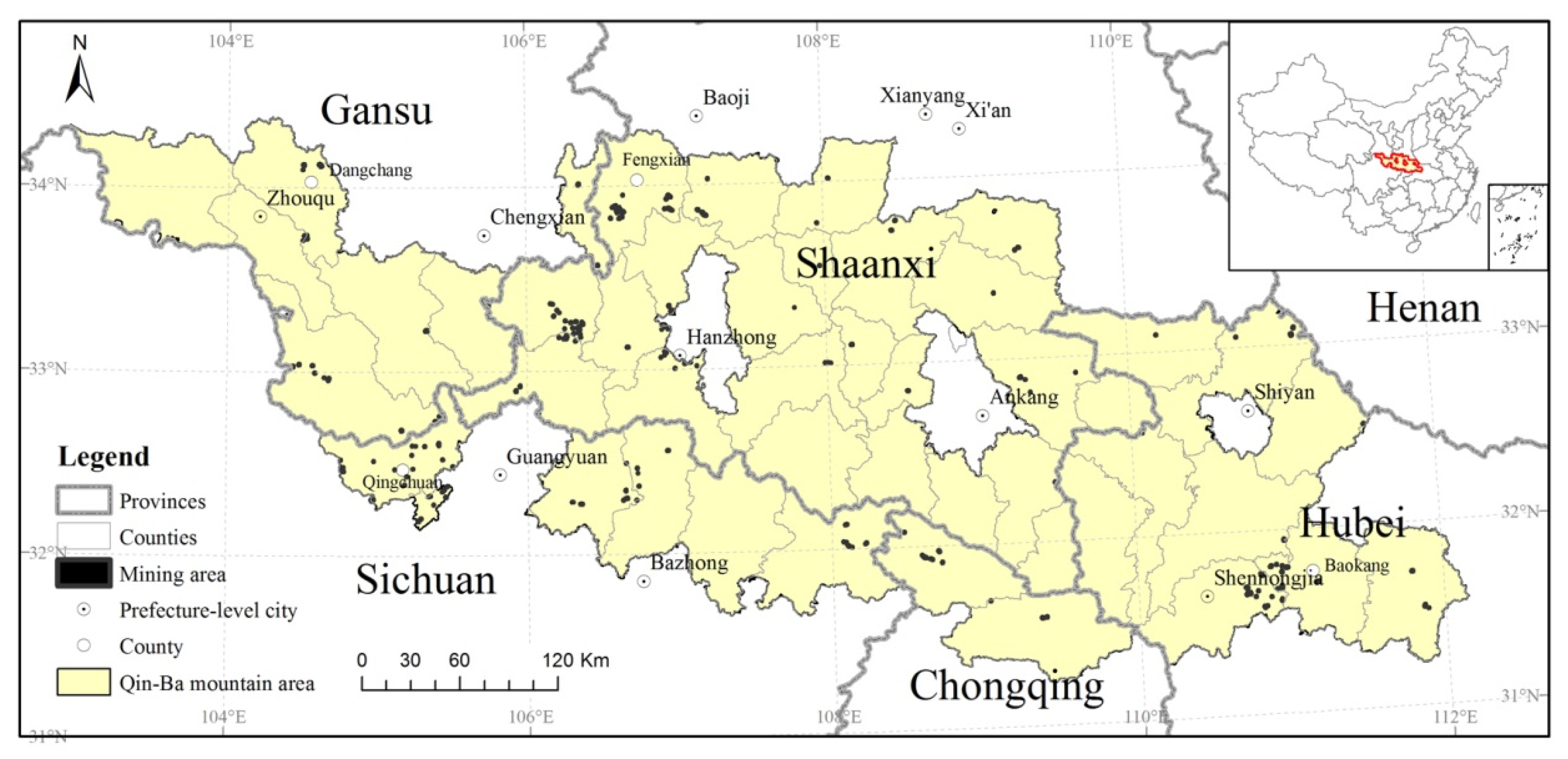
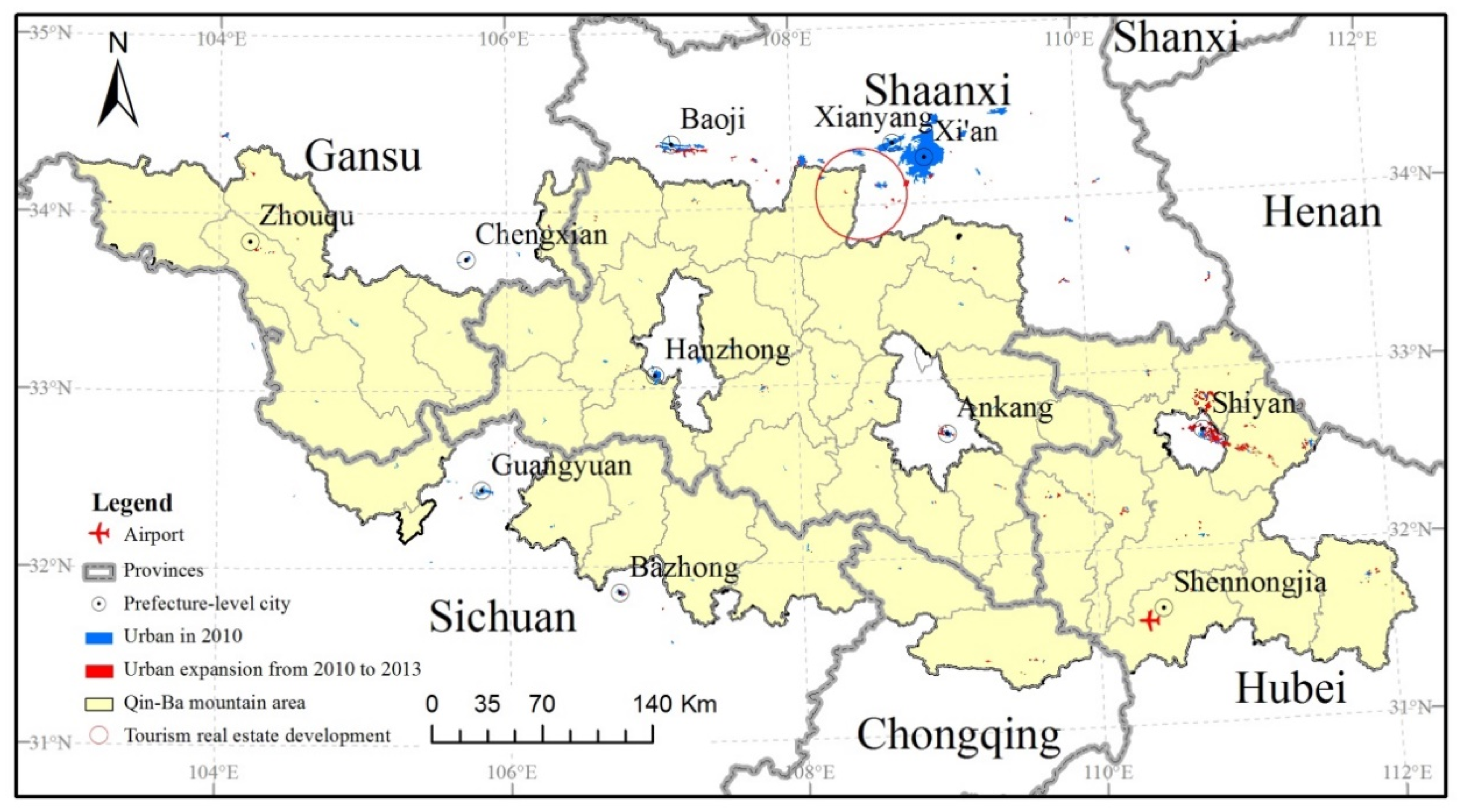
2.1. Study Area

Qin-Ba mountainous area consisting of Qinling and Daba Mountains, is an important ecological barrier in central China. The Qin-Ba mountainous area borders the Weihe River Plain in the north, the Sichuan Plain on the south, it faces the Hanjiang River Plain on the east and the eastern edge of the Tibetan Plateau on the west [17,18]. This area consists of 46 counties spanning 5 provinces: Hubei, Chongqing, Sichuan, Shaanxi and Gansu with a total land area of 140,000 km2 (Figure 1).
Qin-Ba mountainous area is rich in wildlife resources and also provides a habitat for rare animals and plants species. This region makes up 1.46% of China’s total land area and is home to 8.25% of China’s vertebrates and 12.34% of their vascular plants [23]. The typical vegetation in the Qin-Ba mountainous area includes deciduous broad-leaved forests, subtropical evergreen and deciduous broad-leaved forests. Its altitude ranges from 2000 to 3767 m. Soil types, especially brown forest soil, support a variety of distinctive plant and animal communities. In this region, 57.3% of the land area is forest-covered while the remaining includes croplands (20.36%), grassland (20.94%), bodies of water (0.6%), built-up area (0.49%) and unused land (0.31%). Statistics indicate that there are over 550 species of wild vertebrates recognized in this area. These include 19 of the “first class” and 72 of the “second class” national protected animals. In addition, it provides a habitat for over 4100 species of vascular plants among which six are identified as “first class” and 26 are “second class” national protected plants [23].
The Qin-Ba mountainous area has been selected as a vital component of China’s ecological security pattern for biodiversity protection and water conservation based on the current state of its ecological environment. The major functions of the Qin-Ba mountainous area, according to the national plan for ecological functional zones, are for protecting, restoring and maintaining the sustainability and balance of wildlife population and species.
The Qin-Ba mountainous area is also rich in mineral resources. According to the statistics from China Geological Survey, there are over 105 types of exploitable mineral resources in these areas, which account for 64.14% of the mineral resources explored in China. The top five mineral resources are limestone, molybdenum, mercury, asbestos and graphite. These minerals are not only available in quantity, but also in higher quality [20]. However, mining activities and urbanization generally bring about extensive eco-environmental issues [14,24,25].

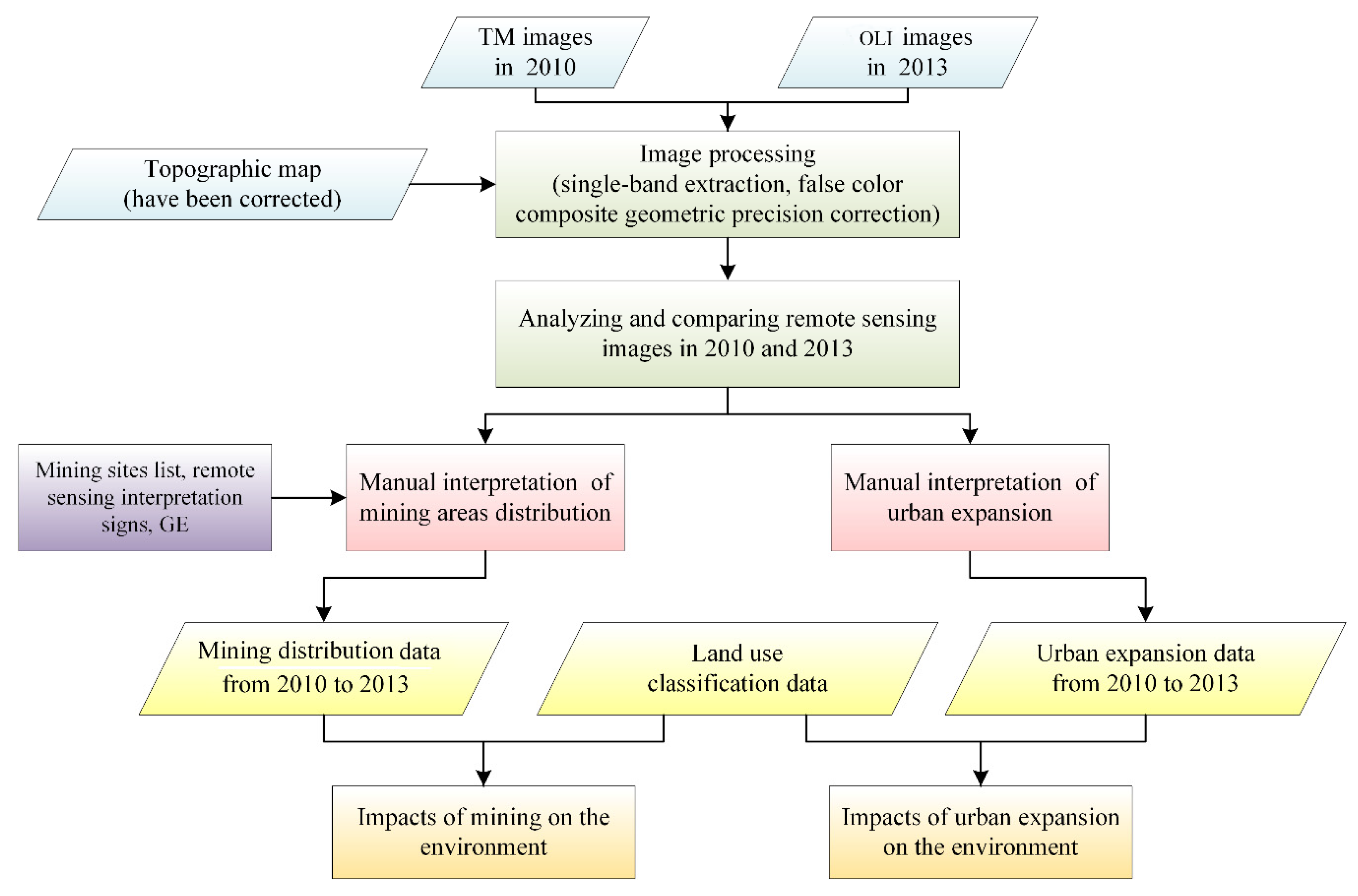
2.2. Data Collection and Analysis

Remote sensing images and other auxiliary data were used to analyze the extent of mining and urban expansion on the ecological environment in the Qin-Ba mountainous area. Images obtained include Landsat 5 TM (Thematic Mapper) in 2010, Landsat 8 OLI (Operational Land Imager) in 2013, and Google Earth high resolution remote sensing images (GE) in 2009, 2010 and 2012. To reduce the impact of clouds on image quality, both the images of 2010 and 2013 were selected in summer on sunny days. Other data including the lists of mining sites and classification of land use were obtained from local government.
Fifteen scenes of Landsat TM/OLI images, covering the whole Qin-Ba mountainous area, were adopted to identify the mining areas and urban expansion through manual interpretation. Manual interpretation rather than automatic interpretation was adopted due to the classification algorithm and is mainly based on the spectral features of the remote sensing image, while manual interpretation takes the comprehensive characteristics of the spectral features and texture of remote sensing images and the key temporal-spatial features of land surface into consideration. Although, manual interpretation of images is seen as a huge barrier to non-expert interpreters, this research took advantage of highly experienced professional image interpreters to minimize errors. In addition, as the research area is a mountainous region, the shade of mountains and bare lands around the mountains interfere with the automatic interpretation of the computer. There were also protocols in place for the image interpreters to follow, to ensure the quality of the interpreted data. Key procedures of the protocols are selecting cloud free images, false-color composite image processing and geometric calibration in order to achieve 2 pixels accuracy. Images were interpreted county by county and finally the data verified by an expert panel.
The OLI images were sourced from Landsat 8 satellite launched on 11 February 2013 by NASA. This satellite has two earth imaging sensors on-board: the OLI and the Thermal Infrared Sensor (TIRS) [26]. The Landsat 5 and 8 images were processed using single-band extraction methods, false color composite, geometric correction and finally forming standard false color images of the Qin-Ba mountainous area (Figure 2).
Further study and analysis was performed in the largest mining counties. Data of mining area distribution and urban sprawl were acquired through manual interpretation of the satellite images. The interpretation of mining area distribution involved drawing mining area polygons by visual interpretation based on Landsat TM/OLI images, mining sites list data and the remote sensing interpretation of signs of mining areas (Figure 3). Also the uncertainty of the mining area polygon was verified by GE individually. The interpretation of urban expansion is a process of drawing the dynamic polygons of urban sprawl based on the urban spatial range in 2010 through an analysis and comparison of the remote sensing images in 2010 and 2013 (Figure 2).
Land use/cover classification data were drawn from the land use/cover database with a mapping scale of 1:1,000,000 developed by The Chinese Academy of Sciences (CAS). The database of land use types consists of data from the late 1980s, the mid-1990s, 2000, 2005 and 2010. The land-use type data was classified into 25 categories which were subsequently grouped into six classes: cropland, woodland, grassland, water body, built-up area and unused land [27,28,29,30,31]. The data from the 2010 database for land use/cover distribution in the Qin-Ba mountainous area was drawn for this study.
Spatial overlay analysis was used to combine the data of mining area distribution, urban expansion and land use classification respectively. The impact of mining and urbanization on the ecological environment in the Qin-Ba mountainous area was then analyzed using the spatial statistical method (Figure 2). The spatial statistical methods used in this research are the built-ins of ARCGIS software such as Map Algebra, Overlay, Reclass and Zonal. Accuracy of assessment was performed by comparing the interpreted results of sampled mining and urban areas with both the data from the field investigation and the high resolution Google images. It is noted that the accuracies of mining occurrences were 94.5% and 92.3%, respectively.

3. Results and Discussion

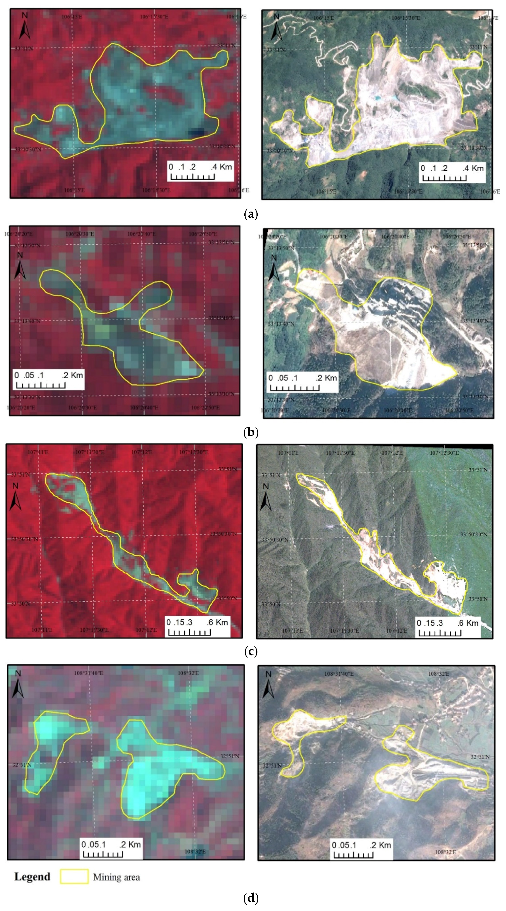
3.1. Mining in the Qin-Ba Mountainous Area

Three hundred and sixty (360) mining areas were discovered during the remote sensing monitoring, occupying a total land area of 22 km2. The four largest mining areas were found in: Baokang County, northwest of Hubei Province with a mining area 4.7 km2; Fengxian County, southwest of Shaanxi Province with a mining area 2.6 km2; Qingchuan County, south of Sichuan Province with a mining area 2.3 km2 and in Dangchang County, southwest of Gansu Province with a mining area about 2 km2 (Figure 1). Land area under mining expanded by 8.4 km2 between 2010 and 2013 which was previously mainly farmland and forestry.
Mining industry is characterized by massive energy and water consumption, especially in the process of excavation and mineral separation. The Qin-Ba mountainous area has an abundant supply of surface water and electricity, creating a good foundation for mining practice [20]. From the perspective of local government, economic development through mining is of top priority. Thus a lot of investment has been placed into mineral resources development which includes advanced production technology and scale expansion in the Qin-Ba mountainous area [32,33]. As a result the mining industries have contributed to local economic development, however, mining has also endangered the local ecological environment in many ways.

3.2. The Impact of Mining on the Ecological Environment

Minerals exploration and exploitation by various methods brings hazards to the environment and its people. It especially changes the topography and local hydro-geological conditions. Mining strips more of the Earth’s surface each year than natural erosion [34]. Waste rock includes the “overburden” and mine development rocks typically hauled from the mine site to waste dumps for disposal. Some of the mines even use toxic chemicals to extract metals from ores, which may pollute lakes or rivers if not properly treated [35]. During the active life of the mine, water is pumped out to keep the mine dry and to allow access to the ore. This water can be very acidic and laden with high concentrations of toxic heavy metals posing threats to the environment. Mining activities also cause health problems in the local communities and among wildlife by exposing them to mining waste in air, water and soil [24,34,35,36,37,38]. The large-scale mining in the Qin-Ba mountainous area is posing direct and indirect threats to the local ecosystem [39,40].
Land intrusion and damage caused by mining is extremely severe in the Qin-Ba mountainous area. According to the land survey, approximately 8.37 km2 of lands in the Qin-Ba mountainous area has been lost due to mining practices, among which 36.6% was forest land, 32.5% cultivated land, and 26.6% grassland. In addition 0.36 km2 of water area and 0.01 km2 of unused lands have been taken over for mining as well. As important components of the ecosystem, the loss of cropland, vegetation cover and water body have led to soil erosion, reduced biodiversity and induced extinction of species [17]. Waste generated during the mining process is another critical threat to the environment. For example, water and soil resource contaminations were identified in these regions [23]. The removal of minerals and slags also caused geological issues such as ground subsidence and landslides.
To achieve a better understanding of the impact of mining on the ecosystem, further study and analysis of lead-zinc mining in Fengxian County, Shaanxi Province and phosphate mining in Baokang County, Hubei Province was done.

3.2.1. Lead-Zinc Mining in Fengxian County, Shaanxi Province

Fengxian County situated in the southwest of Shaanxi Province, is famous for its abundance of lead-zinc resource. Fengxian County contributes 3.6 million tons of lead-zinc reserve making it one of the four national lead-zinc resource bases. Fengxian County has a long mining history. Among the 49 national nonferrous metal mining areas, five of them are located in Fengxian County. Mining contributed to over 75% of local GDP in Fengxian County. However, environmental challenges and pollution resulting from mining have been well documented since the 1970s [32,41,42].
The images from remote sensing showed that the mining area in Sancha, Fengxian County expanded 0.36 km2 from 2010 to 2013 mainly through farmland intrusion. This resulted in the expansion of the mining area to 0.72 km2 representing 50% of mining area in Fengxian County. Piles of lead-zinc slag can be detected from satellite images and the mining waste area is about 112 m from south to north and 26 m from east to west. Land which used to be covered by trees and used for farming are now covered by slags. Furthermore, over-exploitation of mineral resources and improper storage of slags has resulted in geological disasters. For example, multiple geological disasters as a result of debris flow and landslides have occurred in the mining areas of Fengxian County in 1981, 1990 and 1992 which led to a direct economic loss over one billion Chinese Yuan [41]. Other impacts of mining include air, water, soil pollution and contaminated vegetation as a result of pollutants from mining dust, waste water and gas. For instance, the leakage of a tailing pond in 2006 discharged tons of hazardous pollutants into the River in Fengxian County resulted in contamination of the water and wildlife [42].

3.2.2. Phosphate Mining in Baokang County, Hubei Province

Baokang County located in the northwestern Hubei Province, lies in the east of Qin-Ba mountainous area. It is estimated that the phosphate reserves in Baokang County is 337 million tons, and it known in central China as “the city of phosphate” [33]. The images of the remote sensing showed that its mining area occupied more than 1.76 km2 of land of which 84% was forest. The intensive phosphate mining in Baokang County unavoidably interferes with the local ecosystem causing pollution to the air, soil and water. Moreover, the rivers have also been clogged with phosphate slags [43].

3.3. Urbanization in the Qin-Ba Mountainous Area

China has experienced unprecedented urban expansion in the last three decades with a 1.34 billion population, over half of which residing in cities [44]. Urban land expansion is more intensive when compared with urban population growth in Chinese cities. Researchers have found that between 1993 and 2009, the total population living in prefectural cities increased by 75 percent from 126.57 million to 219.82 million [25]. On the other hand, built-up urban areas more than doubled over the same period, from 10,549 km2 in 1993 to 26,100 km2 in 2009 [23].
The urbanization in the Qin-Ba mountainous area took on an obvious spatial heterogeneity since 2005. The urban area in the central and eastern Qin-Ba mountains including the cities of Hanzhong, Ankang and Shiyan has expanded by 85.58 km2 from 2010 to 2013. This includes 80.3 km2 newly built-up areas in the Shiyan City, which accounts for 93.8% of the total increase. The diversity of tourism resources in Shennongjia, South of the Qin-Ba mountainous area, has accelerated the urban expansion process through the construction of an airport and tourism related infrastructure and facilities. A 5.7 km2 expansion area occurred to the west of the Qin-Ba mountainous area in an effort to rebuild the cities damaged by the disaster of the Zhouqu debris flow on 7 August 2010 [45]. Guanzhong Urban Agglomeration to the north of the Qin-Ba mountainous area has expanded significantly by 51 km2, with the largest increased occurring in the city of Baoji having a total increase in area of 25.1 km2 within the study period (Figure 4).

3.4. The Effects of Urbanization on Ecological Environment

The urban expansion in the Qin-Ba mountain area has led to a reduced area of forest and cultivated land. In the central and eastern Qin-Ba mountainous area, an area of 40.69 km2 forests and 25.81 km2 farmland were converted into urban land between 2010 and 2013. The expansion of Guanzhong Urban Agglomeration to the north of the Qin-Ba mountainous area has also resulted in an increase of urban land use by a total area of 53.63 km2, including farmland 34 km2, water body 6 km2, grassland 2.9 km2 and forest 1.7 km2. The decreased area of water body was due to landscaping for urban infrastructure. The Baoji and Xi’an Cities, being the important parts of the Guanzhong urban agglomeration, have also expanded significantly towards the Qin-Ba mountainous area. It is projected that the vegetation cover will be further reduced due to future urban expansion [46].
The conversion of cultivated land and deforestation into urban land has caused a series of environmental problems that include landslide, increased soil erosion and debris flow during the wet season [13]. Furthermore this has also led to the loss of wildlife due to damaged habitat. The process of urban encroachment is also accompanied by the pollution of water and air quality. Urban waste, especially the construction waste is generally dumped without treatment which has resulted in air and groundwater pollution [47].
The most severe ecological environmental impacts caused by urban encroachment is related to the rapid expansion of Shiyan City, the airport construction program in Shennongjia district and the booming tourism industry in the northern Qin-Ba mountainous area.

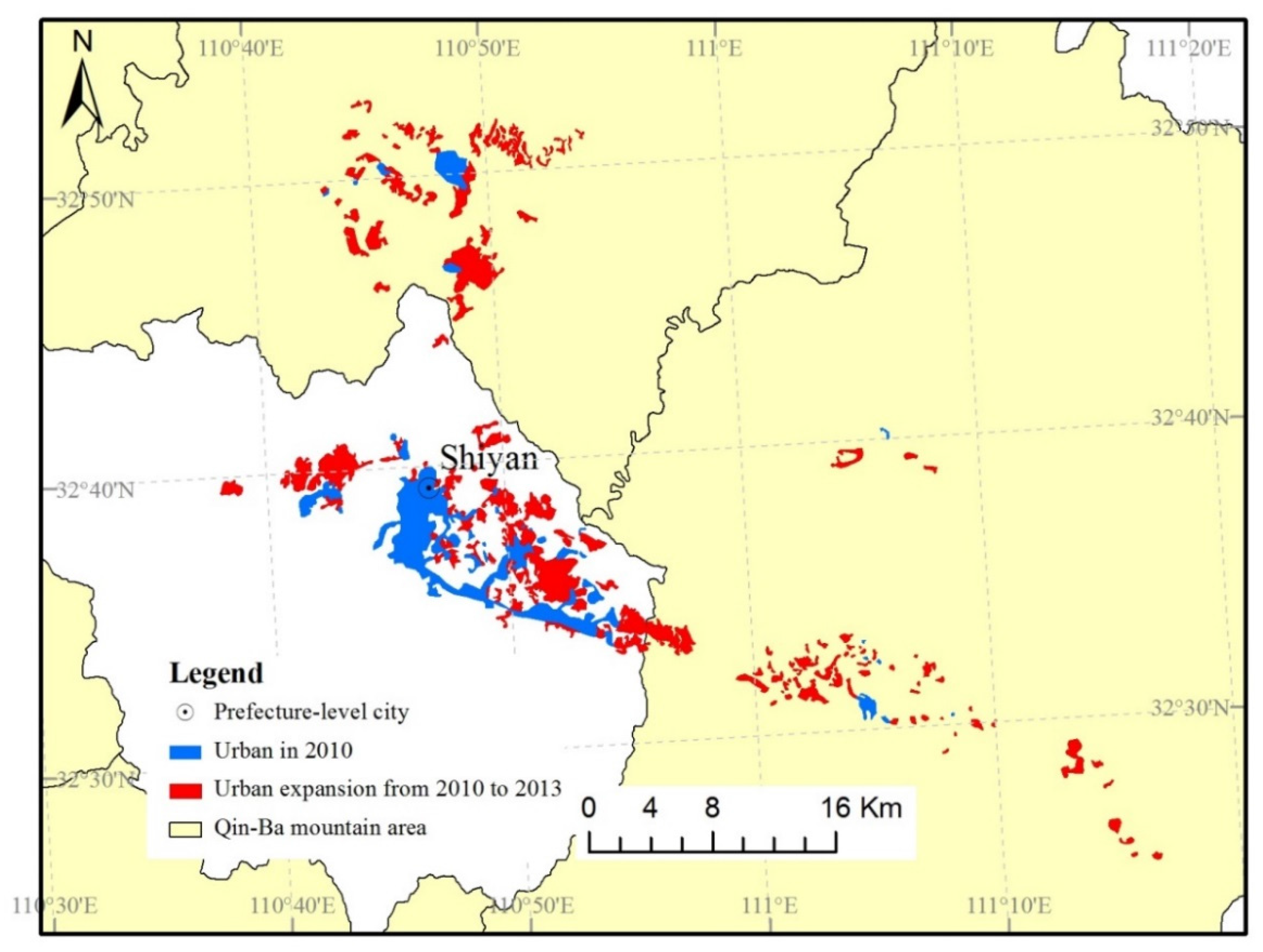
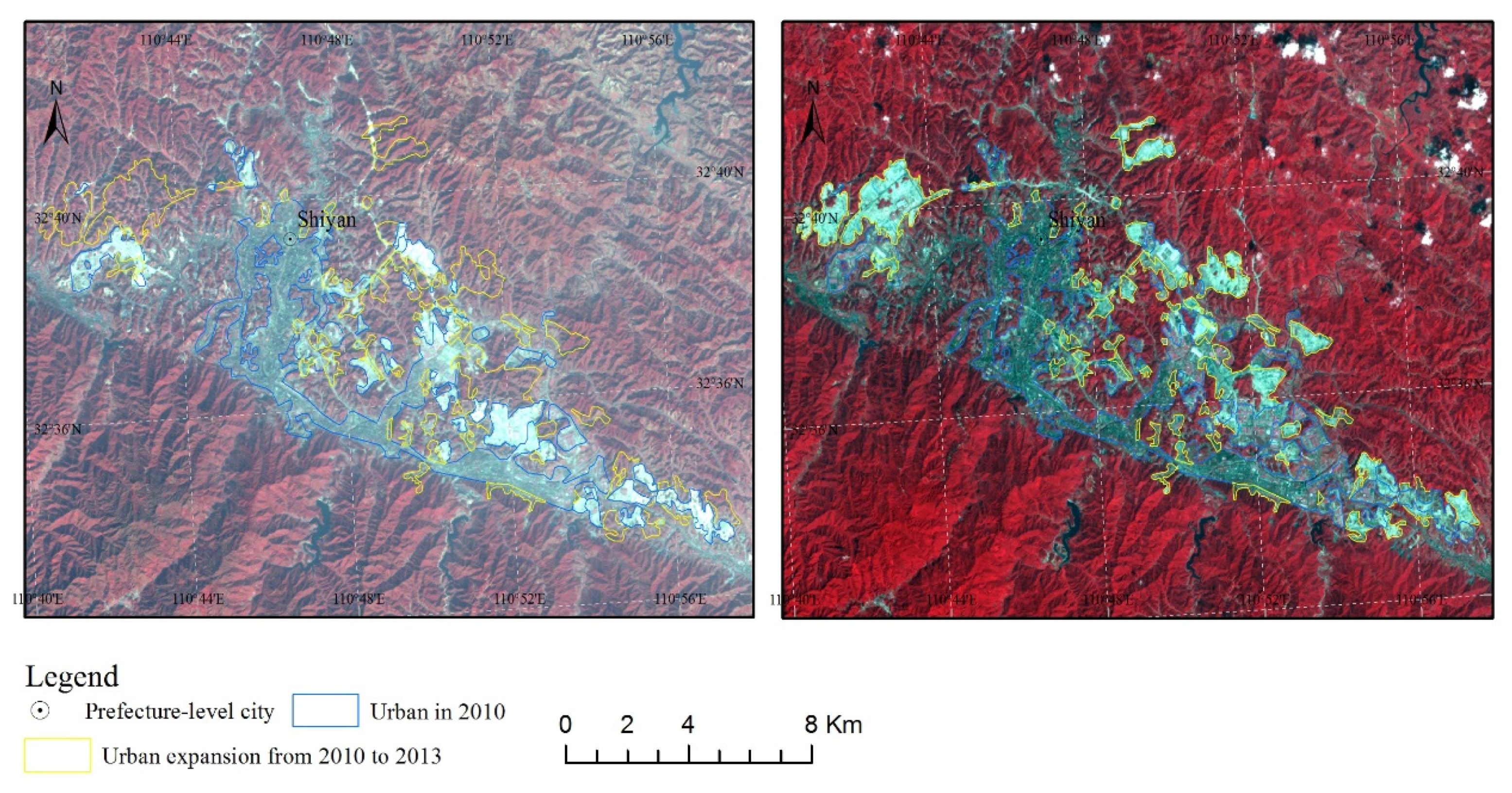
3.4.1. The Expansion of Shiyan City

Shiyan is a typical mountain city located in the northeastern Qin-Ba mountainous area, with mountains accounting for 92% of the total landscape. The Shiyan City Council has launched an ambitious program which will invest billions of Yuan to double the city size by 2020 [48]. In order to further expand the city, mountains within the plains have to be flattened to gain more space. Out of the total 86 km2 of mountains to be flattened to gain more land space for development, 80.2 km2 was converted and built up between 2010 and 2013. Consequently at least 50% of the area will be converted from forest and the remainder consisting of cropland, grassland and water. The satellite images shown in Figure 5 and Figure 6 include the expanded built-up areas in the Shiyan City between the years 2010 and 2013.
Some researchers have argued that the flattening and landscaping of mountains is dangerous because of its associated changes of complex geological and hydrogeological conditions [49]. Cutting mountain tops to fill valleys destroys the physical environment, the aesthetic value, blocks and pollutes water sources thus endangering wildlife and causing geological hazards. Since Shiyan is close to one of the water sources for the South-to-North Water Diversion Project, the alternation of landscape poses a real threat to this national project in terms of pollution and obstruction of the water way. Besides flattening the mountains, some traditional agricultural lands have been claimed to pave the way for urban construction in Shiyan City.

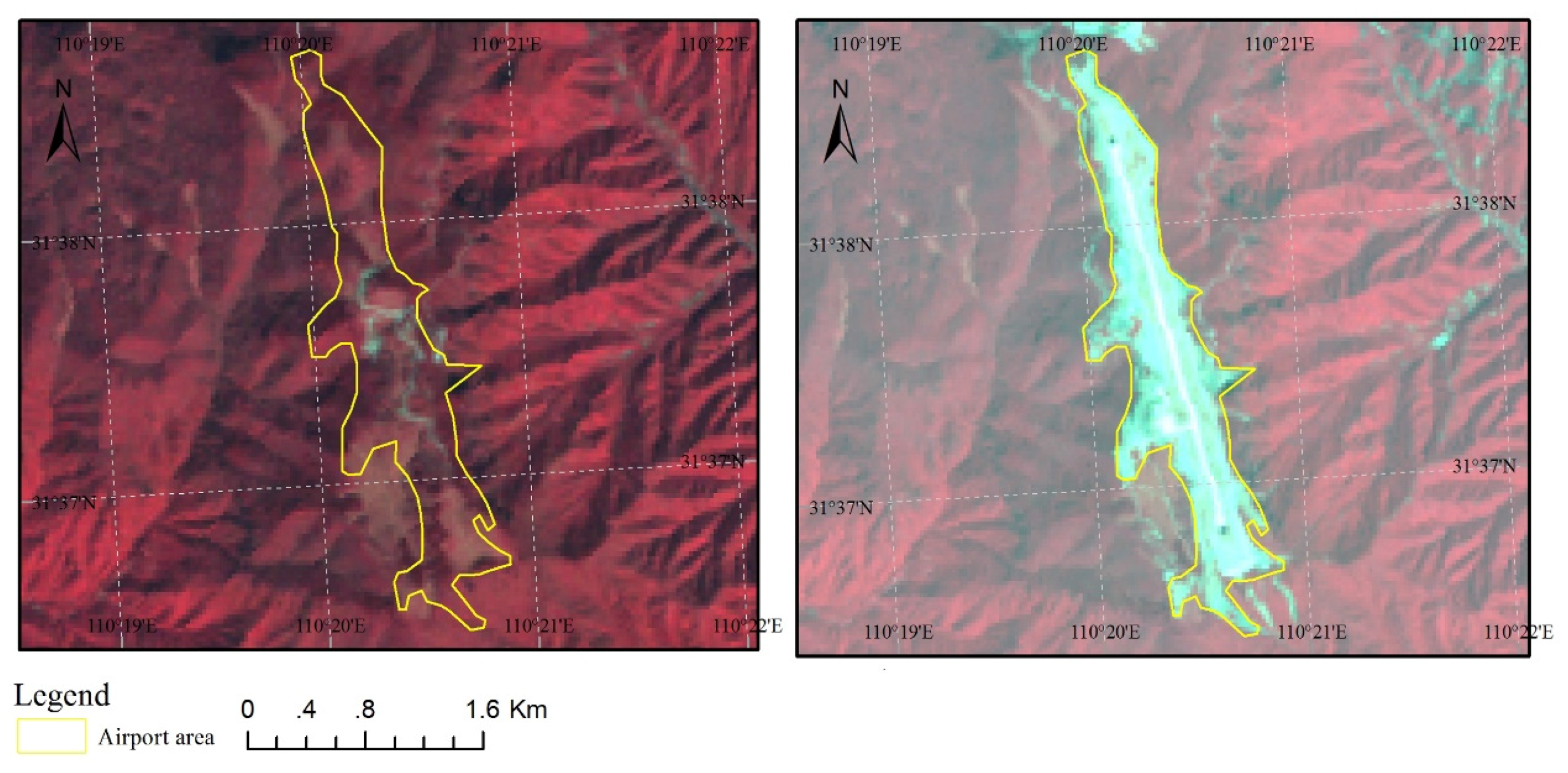
3.4.2. Construction of the Shennongjia Airport

The Shennongjia Airport will serve the Shennongjia District and its surrounding regions in the southeastern Qin-Ba mountainous area. The airport has been designed to take 250,000 passengers and 1000 tons of air cargo annually by 2020. Large areas of forest were cleared and 11 mountain tops were flattened to fill six valleys in order to make way for the airport construction (Figure 7), commenced in April 2011 with its formal operation starting in May 2014. The result of remote sensing monitoring in 2013 showed that this airport occupies a land area of 1.112 km2.
The construction of this airport has attracted much controversy in China due to the significant damage to the environment [50]. Firstly, the Shennongjia district serves as a habitat to many precious plants and animals including over 70 species of national key preserved animals, such as the black bear, leopard, etc. [51]. However, the noise created during construction and the demolition of forest has forced some of these animals to flee resulting in a decreased biodiversity. Secondly, tree roots generally play an important role in binding soil together; however the clearing of trees on steep slopes increased the risk of landslides [52]. Thirdly, Yang [50] expressed that without an efficient and reasonable regulatory system, the sewage and garbage generated from the airport could further affect the local environment. Due to existing regulations on economic development and environmental protection, problems have arisen due to a silo management system and an imbalance between local economic development and environmental protection.

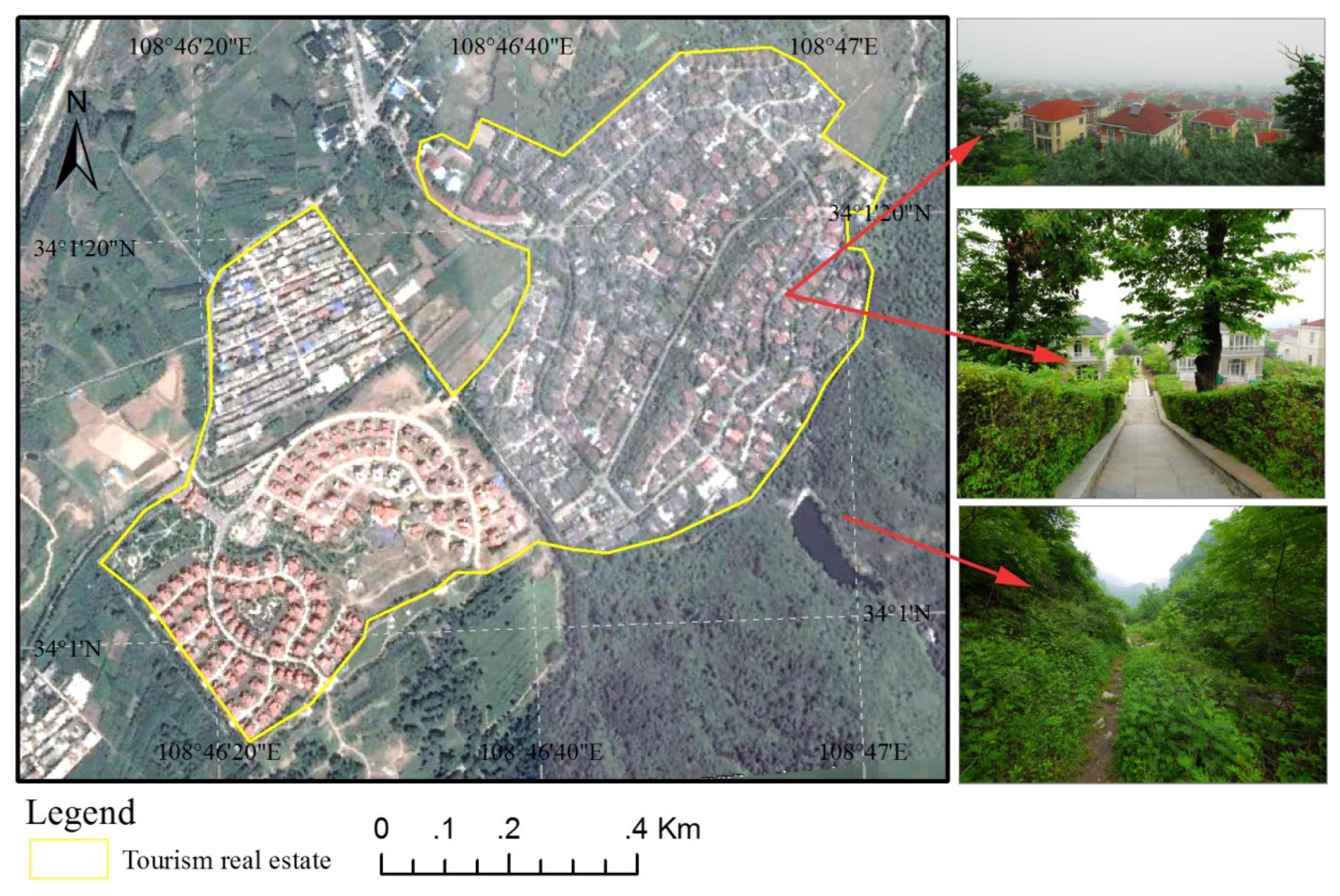
3.4.3. Real Estate Development in Tourism

Real estate development in the tourism industry, especially luxury commercial property, contributes further to urban expansion [49]. The Qin-Ba mountainous area is known as the “Central Park of China”. The scenic spots and historical sites of the area attract an increasing number of domestic and international tourists. As a result of the booming tourism industry, the demand for holiday homes and other tourism facilities has attracted the attention of local governments and investors. In the past decade a large amount of capital has been invested to renovate the old tourism infrastructures and to construct new properties such as hotels, resorts and villas (Figure 8). For example, during the survey a number of villas were under construction along the sides of the road on the edge of the northern Qin-Ba mountainous area. The largest construction projects among them are the “Qinlingshanshui”, “Gaoshanliushui” and “Andeluxiya” villa communities covering a total area of 1.008 km2 and forming large clusters of properties as shown in Figure 8.
However, the occupancy rates of the built-up villas are very low. Some hotels and villas are vacant most of the time. The survey revealed that some real estate developer constructed projects were without the legal approval of local and national authorities [53]. Furthermore, some projects were launched under the name of tourism infrastructure but instead were built as villas for sale. Mountains have been leveled for real estate and economic development with the large scale of construction having severely damaged the ecosystem in the Qin-Ba mountainous area [49].

4. Conclusions

As analyzed above, the degradation of the ecological environment induced by mining and urbanization are severe and extensive in the Qin-Ba mountainous area. Land use changes for built up areas due to urbanization have expanded by 85.58 km2, mining area increased by 8.4 km2 and the Shennongjia Airport took up further 0.74 km2 in the time period from 2010 to 2013. Mining is one of the most dominant local industries supported by the local government for economic development. As a result, the intensity of mining in both numbers and scale is increasing at an accelerated rate. The utmost impact from urbanization, especially the expansion of Shiyan City, has resulted in encroachments of large areas of land through the flattening of mountain tops, the filling of valleys, the clearing of forests and cultivated land. The construction of the airport in Shennongjia district has also brought about an ecological impact that goes far beyond its construction period. The booming tourism industry and associated real estate development in the northern Qin-Ba mountainous area has also escalated environmental issues.
To safeguard the ecological environment from further damage, the following interventions should be considered by governments, communities and policy makers: First, the existing regulations should be further enforced in the sectors of mining, urban and especially tourism development. For instance, the Environmental Impact Assessment (EIA) has been in use since the Environmental Protection Law was passed in 1979 and the law of EIA has been in place since 2002 [54]. However, all the consequences associated with the environmental challenges in the Qin-Ba mountainous area indicated that the laws and regulations related to natural resources and environmental protection should be further strengthened and enforced. To ensure sufficient enforcement, it requires an integrated approach in government enforcement departments to curtail the silo management system, which can prevent the imbalance between local economic development and environmental protection. Secondly, local governments should always promote local and regional development initiatives in a sustainable way to ensure that developments are consistent with the Sustainable Development Strategies implemented by the Central Government since 1994. This will ensure that sustainable development in the Shiyan City does not endanger biodiversity and cause other such disasters. For example, the booming mining industries are characterized by many clusters of small size mining fields, making monitoring and control by the local authorities difficult. This is due to the many small scale mining fields operated in very simple conditions. Compared to economic development, environmental protection is always secondary in the region which is still restrained by poverty. This leads to inefficiencies in both the production and sustainability of the environment. Thus, local government should not approve numerous small and inefficient mining businesses without assessing the sustainability of the industry. In the case of Shiyan City, the rapid expansion in its size has resulted in environmental consequences making its sustainability questionable. Thirdly, ecotourism rather than mass tourism should be developed in the Qin-Ba mountainous regions. Ecotourism would contribute to the local economy with minimal environmental impact, if tourism developers follow the process. Ecotourism products include natural scenic views, culture experiences, arts and traditional history which aim to ensure the integrity of local ecosystems. The targeting of commercialization for real estate in the tourism industry contradicts the essence of ecotourism. Fourthly, environmental education and training programs should be initiated by local governments and educational institutions for public environmental awareness. Many of the environmental issues can be attributed to the lack of environmental awareness amongst the general public [55].
Finally, this study among many others, demonstrates that by using remote sensing, land use change can be efficiently monitored. The principal advantages of remote sensing are the synoptic view and the speed at which data can be acquired from large areas of the earth’s surface and the related fact that comparatively inaccessible areas such as the Qin-Ba mountainous regions were made accessible in this research. In addition, the remote sensing satellites provide repetitive coverage of the earth and this temporal information is very useful for studying landscape dynamics, phenological variations of vegetation and change detection analysis. Since information about a large area can be gathered quickly, the techniques save time and human effort which enhances decision making effectiveness and saves time. Remote sensing, especially when conducted from space, is an intrinsically expensive activity. Nevertheless, cost-benefit analysis by Johnson and Haley [56] demonstrates its financial effectiveness, and speculative or developmental remote sensing activity can be justified in this way. Thus, it is recommended that local or regional governments should adopt such monitoring methods for efficiency and cost effectiveness.

Acknowledgments

This research was supported and funded by the National Key Project of Scientific and Technical Supporting Programs (No. 2013BAC03B01), project of CAS Action-plan for West Development (No. KZCX2-XB3-08-01), and the Important National Project of High-resolution Earth Observation System (No. 05-Y30B02-9001-13/15-10).

Author Contributions

Xinliang Xu and Daowei Sun conceived and supervised the study; Hongyan Cai and Lan Hu assisted data collection and analysis; Daowei Sun and Kwamina Banson led and completed the writing.

Conflicts of Interest

The authors declare no conflict of interest.

References

  1. Keesstra, S.; Maroulis, J.; Argaman, E.; Voogt, A.; Wittenberg, L. Effects of controlled fire on hydrology and erosion under simulated rainfall. Cuad. Investig. Geogr. 2014, 40, 269–294. [Google Scholar] [CrossRef]
  2. Liang, X.; Zhang, W.; Chen, L.; Deng, F. Sustainable urban development capacity measure—A case study in Jiangsu Province, China. Sustainability 2016, 8, 270. [Google Scholar] [CrossRef]
  3. Tiwari, P. Land use changes in Himalaya and their impacts on environment, society and economy: A study of the lake region in Kumaon Himalaya, India. Adv. Atmos. Sci. 2008, 25, 1029–1042. [Google Scholar] [CrossRef]
  4. Li, P.; Qian, H.; Wu, J. Environment: Accelerate research on land creation. Nature 2014, 510, 29–31. [Google Scholar] [CrossRef] [PubMed]
  5. Xu, X.; Min, X. Quantifying spatiotemporal patterns of urban expansion in china using remote sensing data. Cities 2013, 35, 104–113. [Google Scholar] [CrossRef]
  6. Huang, D.; Jin, H.; Zhao, X.; Liu, S. Factors influencing the conversion of arable land to urban use and policy implications in Beijing, China. Sustainability 2015, 7, 180–194. [Google Scholar] [CrossRef]
  7. Zhao, G.; Mu, X.; Wen, Z.; Wang, F.; Gao, P. Soil erosion, conservation, and eco-environment changes in the Loess Plateau of China. Land Degrad. Dev. 2013, 24, 499–510. [Google Scholar] [CrossRef]
  8. Peng, F.; Quangang, Y.; Xue, X.; Guo, J.; Wang, T. Effects of rodent-induced land degradation on ecosystem carbon fluxes in an alpine meadow in the Qinghai–Tibet Plateau, China. Solid Earth 2015, 6, 303–310. [Google Scholar] [CrossRef]
  9. Li, L.; Wu, Y. Application of remote-sensing-image fusion to the monitoring of mining induced subsidence. J. China Univ. Min. Technol. 2008, 18, 531–536. [Google Scholar] [CrossRef]
  10. Malaviya, S.; Munsi, M.; Oinam, G.; Joshi, P.K. Landscape approach for quantifying land use land cover change (1972–2006) and habitat diversity in a mining area in Central India (Bokaro, Jharkhand). Environ. Monit. Assess. 2010, 170, 215–229. [Google Scholar] [CrossRef] [PubMed]
  11. Zhai, M.; Xu, X.; Jiang, D.; Jiang, X. Remote sensing monitoring of the ecological environment in Wuhai Mining Area since 1979. Remote Sens. Technol. Appl. 2012, 27, 933–940. [Google Scholar]
  12. Li, N.; Yan, C.; Xie, J. Remote sensing monitoring recent rapid increase of coal mining activity of an important energy base in Northern China, a case study of Mu Us Sandy Land. Res. Conserv. Recycl. 2015, 94, 129–135. [Google Scholar] [CrossRef]
  13. Hassan, M.M.; Nazem, M.N.I. Examination of land use/land cover changes, urban growth dynamics, and environmental sustainability in Chittagong city, Bangladesh. Environ. Dev. Sustain. 2016, 18, 697–716. [Google Scholar] [CrossRef]
  14. Wang, S.; Ma, H.; Zhao, Y. Exploring the relationship between urbanization and the eco-environment—A case study of Beijing–Tianjin–Hebei region. Ecol. Indic. 2014, 45, 171–183. [Google Scholar] [CrossRef]
  15. Gomiero, T. Soil degradation, land scarcity and food security: Reviewing a complex challenge. Sustainability 2016, 8, 281. [Google Scholar] [CrossRef]
  16. Cao, C. On land development and utilization in mountainous cities in the Western Region of China. Planners 2003, 7, 72–74. [Google Scholar]
  17. Sun, Z.; Wang, Y.; Chang, J.; Wang, Y. The strategic position of Qin-Ba mountain area in the protection of ecological environment. Environ. Sci. Technol. 2001, 24, 60–61. [Google Scholar]
  18. Liu, X.; Pan, Y.; Zhu, X.; Li, S. Spatiotemporal variation of vegetation coverage in Qinling-Daba Mountains in relation to environmental factors. Acta Geogr. Sin. 2015, 70, 705–716. [Google Scholar]
  19. He, J. Experience and problems in ecological environment construction of Qin-ba mountain area. Tangdu J. 2005, 3, 53–57. [Google Scholar]
  20. Li, N.; Guo, C.; Hui, Z.; Ma, Z. A study on the exploitation and utilization of mineral resources and regional sustainable development in Qinling-Daba Mountain of Southern Shaanxi. Res. Sci. 1999, 21, 31–34. [Google Scholar]
  21. Weng, Q. Land use change analysis in the Zhujiang Delta of China using satellite remote sensing, GIS and stochastic modelling. J. Environ. Manag. 2002, 64, 273–284. [Google Scholar] [CrossRef]
  22. Treitz, P.M.; Howarth, P.J.; Gong, P. Application of satellite and GIS technologies for land-cover and land-use mapping at the rural-urban fringe: A case study. Photogramm. Eng. Remote Sens. 1992, 58, 439–448. [Google Scholar]
  23. SFA. Ecological Protection and Construction Planning of Qin-Ba Biodiversity and Ecological Function Conservation Area; State Forestry Administration of the People’s Republic of China: Beijing, China, 2014. [Google Scholar]
  24. Wang, S.; Liu, C.; Zhang, H. Suitability evaluation for land reclamation in mining area: A case study of Gaoqiao bauxite mine. Trans. Nonferr. Met. Soc. China 2011, 21, s506–s515. [Google Scholar] [CrossRef]
  25. Wei, Y.D.; Ye, X. Urbanization, urban land expansion and environmental change in China. Stoch. Environ. Res. Risk Assess. 2014, 28, 757–765. [Google Scholar] [CrossRef]
  26. Estoque, R.C.; Murayama, Y. Classification and change detection of built-up lands from landsat-7 ETM+ and Landsat-8 OLI/TIRS imageries: A comparative assessment of various spectral indices. Ecol. Indic. 2015, 56, 205–217. [Google Scholar] [CrossRef]
  27. Liu, J.; Liu, M.; Zhuang, D.; Zhang, Z.; Deng, X. Study on spatial pattern of land-use change in China during 1995–2000. Sci. China Ser. D Earth Sci. 2003, 46, 373–384. [Google Scholar]
  28. Liu, J.; Liu, M.; Tian, H.; Zhuang, D.; Zhang, Z.; Zhang, W.; Tang, X.; Deng, X. Spatial and temporal patterns of China’s cropland during 1990–2000: An analysis based on Landsat TM data. Remote Sens. Environ. 2005, 98, 442–456. [Google Scholar] [CrossRef]
  29. Liu, J.; Tian, H.; Liu, M.; Zhuang, D.; Melillo, J.M.; Zhang, Z. China’s changing landscape during the 1990s: Large-scale land transformations estimated with satellite data. Geophys. Res. Lett. 2005. [Google Scholar] [CrossRef]
  30. Liu, J.; Zhang, Z.; Xu, X.; Kuang, W.; Zhou, W.; Zhang, S.; Li, R.; Yan, C.; Yu, D.; Wu, S. Spatial patterns and driving forces of land use change in China during the early 21st century. J. Geogr. Sci. 2010, 20, 483–494. [Google Scholar] [CrossRef]
  31. Liu, J.; Zhang, Q.; Hu, Y. Regional differences of China’s urban expansion from late 20th to early 21st century based on remote sensing information. Chin. Geogr. Sci. 2012, 22, 1–14. [Google Scholar] [CrossRef]
  32. Yao, S.; Tian, M.; Wu, S. Mineral resources exploitation and sustainable development of Fengxian County in Shaanxi Province. Miner. Res. Geol. 2004, 18, 470–475. [Google Scholar]
  33. Peng, S.; Yao, J. Protection of phosphorus mineral resource in Hubei Provinces of China. China Min. Mag. 2005, 14, 30–33. [Google Scholar]
  34. Pearce, D.W.; Turner, R.K. Economics of Natural Resources and the Environment; Hopkins University Press: Baltimore, MD, USA, 1990. [Google Scholar]
  35. Logsdon, M.J.; Hagelstein, K.; Mudder, T. The Management of Cyanide in Gold Extraction; International Council on Metals and the Environment: Ottawa, ON, Canada, 1999. [Google Scholar]
  36. Bell, F.G.; Donnelly, L.J. Mining and Its Impact on the Environment; CRC Press: Boca Raton, FL, USA, 2006. [Google Scholar]
  37. Düzgün, S.; Künzer, C.; Karacan, C.Ö. Applications of remote sensing and GIS for monitoring of coal fires, mine subsidence, environmental impacts of coal-mine closure and reclamation. Int. J. Coal Geol. 2011, 86, 1–2. [Google Scholar] [CrossRef]
  38. Volesky, J.C.; Stern, R.J. Remote sensing and mineral exploration in the Arabian shield: The Wadi Bidah Mining District example. Gondwana Res. 2001, 4, 198–200. [Google Scholar] [CrossRef]
  39. Sonter, L.J.; Moran, C.J.; Barrett, D.J.; Soares-Filho, B.S. Processes of land use change in mining regions. J. Clean. Prod. 2014, 84, 494–501. [Google Scholar] [CrossRef] [Green Version]
  40. Schueler, V.; Kuemmerle, T.; Schröder, H. Impacts of surface gold mining on land use systems in Western Ghana. Ambio 2011, 40, 528–539. [Google Scholar] [CrossRef] [PubMed]
  41. Hou, E.; Hao, Z.; Wang, X. Analysis of geological environment and countermeasures of lead-zinc mine area in Fengxian. Nonferrous Met. (Min. Sect.) 2001, 5, 12–14. [Google Scholar]
  42. Chen, G. Comprehensive assessment and analysis on the status of heavy metal pollution in soil of Yindongliang lead-zinc mine area in Fengxian. Chin. J. Soil Sci. 2013, 1, 222–226. [Google Scholar]
  43. Liu, N. The Present and Future of Phosphate Mining in Hubei. Ind. Mineral. Process. 2004, 33, 1–3. [Google Scholar]
  44. Liu, Y.; Yang, S.; Chen, J. Modeling environmental impacts of urban expansion: A systematic method for dealing with uncertainties. Environ. Sci. Technol. 2012, 46, 8236–8243. [Google Scholar] [CrossRef] [PubMed]
  45. Liu, B.; Song, Y.; Deng, X. Evaluation of the economic loss caused by Zhouqu Debris Flow. J. Agric. Sci. Technol. 2012, 13, 1081–1085, 1132. [Google Scholar]
  46. Guang-wen, L. Cities and environment coordinated development research southern area of Qinling-Bashan Mountain in Shaanxi. Territ. Nat. Resour. Study 2006, 1, 42–43. [Google Scholar]
  47. Yahya, K.; Boussabaine, A.H. Eco-costing of construction waste. Manag. Environ. Qual. Int. J. 2006, 17, 6–19. [Google Scholar] [CrossRef]
  48. Li, A.; Zhou, L. Study on the distinctive characteristic of cities linear muti-unit in mountainous areas: Taking shiyan city as an example. Huazhong Archit. 2012, 9, 114–118. [Google Scholar]
  49. Li, B.; Tian, L. Prevention of ecological risk of tourism real estates at major tourist destinations. Ideol. Front. 2014, 40, 140–143. [Google Scholar]
  50. Yang, H. Is It a Foutune or Disaster to Build Airport in Shennongjia. Green Chin. 2013, 17, 34–39. [Google Scholar]
  51. Zhou, H.; Yu, X.; Luo, T.; He, J.; Zhou, H.; Ye, C. Insect Abundance and Environmental Effects in Shennongjia Natural Reserve, Hubei Province. Chin. Biodivers. 1999, 8, 262–270. [Google Scholar]
  52. Zhang, M.-S.; Liu, J. Controlling factors of loess landslides in western China. Environ. Earth Sci. 2010, 59, 1671–1680. [Google Scholar] [CrossRef]
  53. Tang, W.S.; Chung, H. Rural–urban transition in China: Illegal land use and construction. Asia Pac. Viewpoint 2002, 43, 43–62. [Google Scholar] [CrossRef]
  54. Wang, J. On Modificative Orientation of China Environmental Protection Law. Environ. Prot. 2003, 6, 8–10. [Google Scholar]
  55. Zhang, K.-M.; Wen, Z.-G. Review and challenges of policies of environmental protection and sustainable development in China. J. Environ. Manag. 2008, 88, 1249–1261. [Google Scholar] [CrossRef] [PubMed]
  56. Johnson, J.K.; Haley, B.S. A cost-benefit analysis of remote sensing application in cultural resource management archaeology. In Geophysical and Airborne Remote Sensing Applications in Archaeology: A Guide for Cultural Resource Managers; The University of Alabama Press: Tuscaloosa, AL, USA, 2006; pp. 33–45. [Google Scholar]
Figure 1. The map of Qin-Ba mountainous area.
Sustainability 08 00488 g001
Figure 2. Flow chart for analyzing the impacts of mining and urbanization on the ecological environment in the Qin-Ba mountainous area.
Sustainability 08 00488 g002
Figure 3. Remote sensing images of the mining zones in the Qin-Ba mountainous area (ad). (a) TM image on 10 July 2010, GE image on 23 April 2010, Iron mining area in Shaaxi Province; (b) TM image on 10 July 2010, GE image on 23 April 2010, Iron mining area in Shaanxi Province; (c) TM image on 10 July 2010, GE image on 23 April 2010, Gold mining area in Shaanxi Province; (d) TM image on 10 July 2010, GE image on 23 April 2010, Zinc mining area in Shaanxi Province.
Sustainability 08 00488 g003
Figure 4. Urban expansion in Qin-Ba mountain area.
Sustainability 08 00488 g004
Figure 5. Built up areas and urban expansion in Shiyan City between 2010 and 2013.
Sustainability 08 00488 g005
Figure 6. The TM images of the Eastern Shiyan City. (a) image on 26 November 2010; (b) image on 15 September 2013.
Sustainability 08 00488 g006
Figure 7. Remote sensing images of the Shennongjia Airport. (a) TM image on 16 October 2010; (b) TM image on 15 September 2013.
Sustainability 08 00488 g007
Figure 8. Landscape photo and GE on 29 August 2013 of “Qinlingshanshui” villa community.
Sustainability 08 00488 g008

