Article

Knowledge Brokerage for Impact Assessment of Land Use Scenarios in Inner Mongolia, China: Extending and Testing the FoPIA Approach

1
Leibniz Centre for Agricultural Landscape Research (ZALF), Eberswalder Str. 84, 15374 Müncheberg, Germany
2
Institute of Geographic Sciences and Natural Resources Research, Chinese Academy of Sciences, 11A, Datun Road, Chaoyang District, 100101 Beijing, China
3
Wageningen University and Research Centre, Droevendaalsesteeg 3, 6708 PB Wageningen, The Netherlands
4
Mercator Institute for China Studies, Klosterstr. 64, 10179 Berlin, Germany
5
Berkeley Department of Geography, University of California, 507 McCone Hall, Berkeley, 94702 CA, USA
*
Author to whom correspondence should be addressed.
Sustainability 2015, 7(5), 5027-5049; https://doi.org/10.3390/su7055027
Submission received: 30 December 2014 / Revised: 2 April 2015 / Accepted: 16 April 2015 / Published: 24 April 2015
(This article belongs to the Special Issue Sustainable Land Use and Ecosystem Management)

Abstract

:
While land serves numerous societal functions and contributes to sustainable development, it is often unclear how these functions are affected by political decisions and common drivers of land use change, such as economic development, climate change and demographic change. This study evaluates alternative land use scenarios in reference to a rural region of Inner Mongolia Autonomous Region (China), where various processes and decisions have historically triggered unsustainable development. The scientifically tested “Framework for Participatory Impact Assessment (FoPIA)” method is developed further to address specific features of the case study region, and its function as a knowledge-brokerage (KB) tool is evaluated. Three scenarios are developed and analysed in expert workshops. “Land intensification: Agriculture” and “Land intensification: Mining” scenarios are found to have mainly negative environmental and social effects and positive economic impacts, while the “Environmental conservation and tourism” scenario is found to more positively affect all three sustainability dimensions. Assessments of methodological phases show that the FoPIA primarily serves to establish the KB process and that the framework particularly benefits from early examinations of scientific results by policy makers.

1. Introduction

During recent years, China has benefited from a period of rapid economic growth. At the same time, China has also faced various problems related to land use change [1]. One challenge was to find a balance between economic growth and environmental conservation as well as social stability. This challenge has called for new policy actions to promote sustainable development [
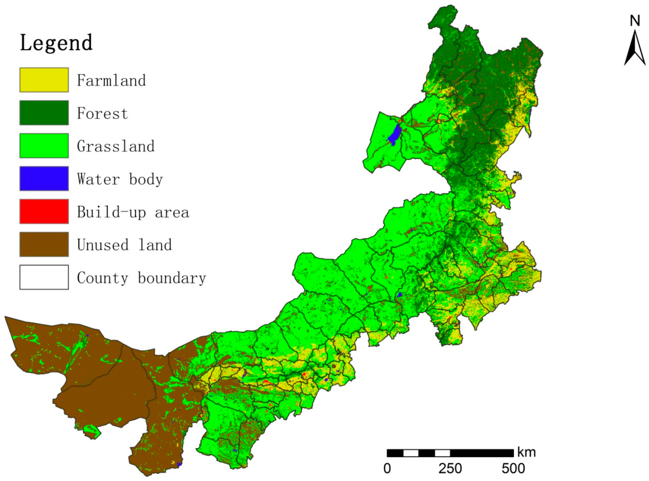
2]. In this study, we examine the example of the resource-rich Chinese Inner Mongolia Autonomous Region (henceforth referred to as Inner Mongolia) that is currently facing such dynamic land use changes. Nomadic grassland pastoralism has long been the dominating land use activity in Inner Mongolia [3]. In recent decades, this picture has dramatically changed for several reasons: rural structural changes due to nationwide economic development and population growth [4] as well as the increasing demand for natural resources. These natural resources refer, for example, to the regionally available “rare earths” [5]. Further, climate change and growing land degradation problems [6] have triggered a number of national policy measures related to higher efficiency resource use and sustainable land management [7,8]. Currently, the main land use changes in Inner Mongolia refer to shifting former pastoralistic grassland management towards agricultural intensification, including animal husbandry and crop production [9,10]; open space mining (mainly coal) [5]; and implementation of environmental restoration programs [11]. In addition, ecotourism is gaining increasing importance [12]. In summary, these changes mainly occur due to policy implementation. However, the sustainability impacts of those land use changes resulting from policy implementation are poorly known. Therefore, ex-ante impact assessment tools are needed, in particular to address policy effects on regional sustainability targets. These goals are to envisage scenario-based land use trends, impacts, and possible trade-offs between defined policy targets and social, economic, and environmental sustainability dimensions.
In research, land use systems are often described as a complex system of human-environmental interlinkages [13,14], which implies that sustainability-oriented land management cannot be based only on quantitative tools. Land management also requires a mixture of different methods that encounter societal norms and stakeholder needs and that are capable of conducting future oriented (ex-ante) assessments to address sustainable development. Such a strategy, however, requires qualitative and participatory assessment methods that can be used to integrate different aspects while also providing new information to support sound political decision-making from an interdisciplinary and stakeholder-driven perspective [15,16,17,18]. In the European Commission, for example, ex-ante impact assessments have become a mandatory instrument for policies. The assessments thereby combine both societal-driven demands and norms from a three-dimensional sustainability perspective (economic, social, environmental) and research-based support from an evidence- or knowledge based perspective [19]. A key purpose of such ex-ante assessments in the decision support of land management is to identify likely policy impacts (before implementation) and to explore possible trade-offs between the economic, the social, and the environmental sustainability dimensions that could, on request, be adjusted and fine-tuned before actual implementation [20].
In contrast, in China, such mandatory (ex-ante) sustainability assessment instruments do not exist at present. Instead, many existing policy assessments either focus only on single impacts (often economic) or only consider two sustainability dimensions (mostly the economic and the environmental dimensions) [21]. Further, for the particular case of land use in Inner Mongolia in China, a recent study by König et al. [22] revealed that there is a mismatch between the interests of local policy makers and the scientific topics addressed in the international literature. While much research has been conducted on topics related to the natural sciences, fewer studies have focused on social, economic and integrated studies. As a result, this mismatch could potentially lead to improper and unspecific political decisions, often implying a “one-size-fits-all” policy design and implementation [23], while increasing the risk of failing to consider an integrative solution for sustainable development in general [24].
Internationally, a variety of quantitative assessment tools exist in the field of land use policies [20,25,26,27]. In this regard, stakeholder participation has been stressed as an important factor by several studies when addressing sustainable development issues related to multifunctional land use [14,28].
In this study, we applied the Framework for Participatory Impact Assessment (FoPIA) for assessing alternative land use change scenarios for the case of Inner Mongolia. FoPIA was originally invented by Morris et al. [29] for the European context to support developing computer-based sustainability impact assessment tools [20,30]. Since then, FoPIA has been developed continuously and applied and tested on a variety of different land use problems in different regions. For example, there have been case studies in China, India, Indonesia, Kenya, Tanzania, and Tunisia [31,32,33,34,35].
One recent emerging research topic that arose while applying FoPIA in this study is the concept of knowledge brokerage (KB). Yet, despite its various applications [29,34], FoPIA as a participatory impact assessment tool had not been analysed with respect to its usefulness for the communication in the science-policy interface. KB addresses different levels, depths and approaches of interaction among policy-makers and researchers, enabling their scientific expertise to be fed into the assessment process. While scientists usually provide profound results, there is no guarantee for their actual application in the policy process, e.g., by an adaptation of the policy based on the assessment results of the responsible governmental units [36]. KB serves as a mechanism to close this gap by improving the cooperation among political decision makers and researchers. The strong interaction among scientists and policy makers addressed in KB has been an emerging scientific topic in the past years. Researchers focused, e.g., on the KB review [15] and the development of KB frameworks, respectively [37], or tested its practical implementation [38,39].
The present study builds on the results of a recent study published by König et al. [22], which aimed to analyse the gap between international research topics and local stakeholder preferences related to multifunctional land use in Inner Mongolia. While making use of the extensive literature survey and analysis provided in König et al. [22], the objective of this study was twofold: first, to further develop and test the FoPIA method for the regional case of Inner Mongolia; second, to reflect on the KB capabilities of FoPIA to identify to what extent FoPIA and its different assessment phases could serve as a support for KB between researchers and decision makers.

2. Materials and Methods

2.1. The Study Area

The Inner Mongolia Autonomous Region is located in northern China and is the third largest province in terms of area in China (Figure 1). As of 2010, major land use types in Inner Mongolia include (Figure 1) grassland (41.5%), farmland (11%), forest (16%), built-up land (0.5%), water bodies (1%), and unused land (30.0%). Its grassland area is one-fourth of China’s total, and its forested area is the second largest among Chinese provinces. Farming and animal husbandry, particularly sheep and goat herding, are the traditional source of subsistence. The climate is characterised by an arid to semi-arid continental climate [40]. In the past two decades, Inner Mongolia’s population and its GDP have grown significantly. According to the 2010 Chinese Census, the population during the past 20 years has increased to 3.25 million people, a growth rate of 13.15%. The ability to maintain a balance between economic growth and ecosystem stability and thus to foster long-term societal sustainability has become a serious challenge facing the people of Inner Mongolia. During the past two decades, an emphasis on industrial and economic growth has greatly transformed this region, and with it has come an increasing pressure on natural ecosystems. As for the regional stakeholder perspectives, we considered a smaller sub-region, that of West Ujimqin, as an exemplary case.
Figure 1. Land use map of the case study area of Inner Mongolia in 2010.
Sustainability 07 05027 g001

2.2. The FoPIA Method

FoPIA provides a structured sequence of methods [29,34] to conduct participatory impact assessments of alternative land use scenarios. FoPIA incorporates the idea of multifunctional land use in which the “land use functions” (LUFs) concept is at the core of the method [29]. LUFs build upon the Ecosystem Services concept [41] and are defined as “goods and services” that summarise the most relevant economic, social, and environmental sustainability issues related to land use [42,43]. Thus, LUFs provide a structured platform to analyse multifunctional land use in a balanced way, following a triple-bottom-line approach [44].
For this study, FoPIA was adapted from König et al. [33], who defined three assessment phases: context analysis, specification of the sustainability context, and scenario impact assessment. In addition to these three phases, we have included two new assessment phases: first, a pre-assessment phase of a comprehensive literature review on region-specific land use issues. Second, a dissemination phase was also incorporated by summarising the key findings in policy briefs to inform decision makers of the potential areas for improved policy making.

2.2.1. Phase 1: Context Analysis (Scientific Literature Review)

A broad survey of the scientific literature related to land use research in Inner Mongolia was conducted in a recent study by König et al. [22]. The aim of this previous survey was to identify the main research topics addressing the different land use topics and also to highlight the different scientific methods and materials used. The research topics were then related to the nine FoPIA land use functions covering multiple sustainability dimensions (economic, social, environmental) (see König et al. [22], supplementary section: http://www.sisef.it/iforest/pdf/[email protected]). For this study, we used this information to provide a solid basis of regional background information, contributing to the following phases 2–4. In addition to this, the author list provided by König et al. [22] was used to compile a contact list of key experts.

2.2.2. Phase 2: Specification of the Sustainability Context

A regional stakeholder workshop was held in the study area of the West Ujimqin region, Inner Mongolia with the participation of ten local and regional decision makers (Table 1). The selection was based on an ongoing regional land use project [10] and thus was initiated through established contacts between the Institute of Geographic Sciences and Natural Resources Research, Chinese Academy of Science and local officials, which is a common procedure when collaboration with international institutes is carried out in rural China. However, based on the study objective, the policy makers invited were to represent the various governmental authorities related to land use with respect to economic, social and environmental sustainable development aspects by considering representatives from the different land use departments [22].
Table 1. Affiliations of the workshop participants.
Decision levelAffiliationNumber of representatives
Local levelBalagaergaole principal town government1
Local levelShutu Gacha (village), Balagaergaole town1
Local levelYilide Gacha (village), Balagaergaole town1
Regional levelAgriculture and Animal Husbandry Bureau of West Ujimqin Banner1
Regional levelClimate and Meteorological Bureau of West Ujimqin Banner1
Regional levelGrassland Supervision Bureau of West Ujimqin Banner2
Regional levelGovernment Office of West Ujimqin Banner1
Regional levelState-run grassland monitoring station of West Ujimqin Banner1
Regional levelWater Conservancy and Forestry Bureau of West Ujimqin Banner1
The aim of the workshop was to obtain information on the perceived importance of social, economic and environmental LUFs and main land use problems affecting rural development in Inner Mongolia from the perspective of local officials. First, the workshop participants were asked to specify the nine LUFs for their region. Second, a preference-based weighing was performed whereby stakeholders could assign weights of the “perceived importance” to the different LUFs (important, less important, very important) [22]. As a result, this phase gained insight into local interests that served as a basis for phases 3 and 4.

2.2.3. Phase 3: Scenario and Indicator Development

The purpose of this phase was to elaborate land use scenarios and to define assessment indicators with knowledgeable scientists in the region. Based on the context analysis (literature survey) (phase 1) [22], and also considering multi-co-authorships, we identified 46 key scientists whose disciplinary background matched with the context of different land use subjects related to research conducted in Inner Mongolia. Their expertise thereby reflected the foci of the literature review with respect to the three sustainability dimensions (26 experts with an environmental dimension, 9 with a social, 7 with an economic background, and 4 scientists covered multiple sustainability dimensions). To minimise possible response bias, we guaranteed that the individual results were confidential.
All scientists were contacted via email twice and were offered phone calls upon request as an optional communication medium. In the first email, we informed the scientists about our research and inquired about their interest in cooperating. Following this previous information, all scientists were contacted again with the request to contribute to the scenario/indicator expert-survey. Fourteen scientists responded to our request to contribute to the survey and send it back to us via email. Due to the background of the respondents, all three sustainability dimensions were covered (eight with an environmental, four with a social, and three with an economic background).
In the survey, researchers were asked to comment on three land use scenario narratives that reflected contrasting possible future development options for Inner Mongolia (see Table 2 for details on the final scenarios). The scenarios were drafted based on the information provided in the literature review (FoPIA phase 1) and implicit knowledge gained during the stakeholder workshop (phase 2). Further, the experts were asked to rank a set of 18 proposed indicators corresponding to the nine land use functions (high relevance, relevance, little relevance). These indicators were derived from previous FoPIA studies [34] and served as a starting point for a balanced selection, while room was also given for new suggestions.
As a result, this phase provided an expert-based elaboration of scenario narratives and assessment indicators that were later used as inputs in the scenario impact assessment for phase 4.

2.2.3.1. Land Use Scenarios

Three scenario narratives with 2010 as baseline references and perspectives regarding the year 2020 were considered; including the scenarios: “land intensification: agriculture”, “land intensification: mining”, and “environmental conservation and tourism” (Table 2).
Table 2. Scenario characteristics.
Area and target yearLand intensification: AgricultureLand intensification: MiningEnvironmental conservation and Tourism
Inner Mongolia 2020Strong promotion of market-oriented agriculture activities. Economic development and an increasing need for resources will lead to more land intensification in the futureStrong promotion of the mining sector. Economic development and increasing need for resources will lead to more land intensification in the future.Environmental conservation activities and ecotourism will gain importance due to governmental programs and a growing middle class in China

2.2.3.2. Assessment Indicators

Based on the responses of the expert survey, a final set of assessment indicators was selected and is presented in Table 3. Notably, we have opted to have no more than one indicator per LUF, as we experienced from previous studies that using multiple indicators per LUF is difficult and not straightforward in workshop settings [29,45,46]. This situation would have been different when doing calculations of multiple indicators per LUF under non-workshop conditions (e.g., when using multi-criteria types of tools) [47].

2.2.4. Phase 4: Scenario Impact Assessment and Trade-Off Analysis

For the scenario assessment, a group of 13 scientists was invited to participate in a workshop held at the IGSNRR-CAS institute in Beijing. Our selection was based on the list of scientists whom we contacted to take part in the expert-survey (phase 3). The aim was to have a group of 15 participants, at maximum, to guarantee a manageable group size that would allow lively exchange and discussions. In addition, we aimed to have a balanced group of experts representing different disciplinary backgrounds. Note that, although those experts who participated in the workshops were paid (which is a common procedure in China), we realised that some high-level experts could not be attracted, which seems to be a general problem that might cause some bias. This issue was also stressed, for example, in a similar study approach conducted by Reed et al. [48].
To begin with, participants were asked to reflect on the different land use functions in general that were presented in the form of a poster and to mark those LUFs in which they felt most knowledgeable and to mention the reasons for this. After this “warm-up activity”, scenario assumptions (Table 2) and assessment indicators (Table 3) developed in FoPIA phase 3 were presented to the group, discussed and specified when necessary to build a common ground of understanding for the assessment. For the scenario assessment, we used the same structure as proposed by Morris et al. [29] and successfully tested in five other cases [34]. Workshop participants were asked to score scenario impacts (−3 to +3) on the nine LUF assessment indicators on a prepared score sheet (anonymous and written). The average impact results for each indicator were presented back to the group. This presentation was followed by a moderated discussion about possible positive and negative scenario impacts. After a group discussion, participants were given the opportunity to make adjustments. In the next step, results of the LUF preferences of the stakeholder workshop in Inner Mongolia on the “perceived LUF importance” of the different LUFs were given (results phase 2, Table 3). The purpose was to combine the stakeholder views with the anticipated expert views on the scenario impacts.
This step allowed for a discussion of the possible sustainability trade-offs between the different LUFs and corresponding sustainability dimensions (economic, social, environmental). Based on this aggregated perspective, possible policy recommendations were discussed, serving as an important input for phase 5.

2.2.5. Phase 5: Formulation of Policy Recommendations

At the end of the scenario impact assessment workshop (phase 4), we asked the participants to provide policy recommendations and needs for future research. The recommendations, together with a summary of key findings, served as the basis to formulate policy briefs for dissemination among decision makers and participating scientists (phase 5). In addition to the scientific use of assessment results and methodological development, dissemination activities for the public are crucial in the participatory impact assessment. Therefore, a summary of the main findings from phases 1–4 was synthesised and was distributed via email to the participating stakeholders in phase 2 (regional and local policy makers) and the experts who participated in the scenario impact assessment workshop (phase 4). After feedback comments, changes were incorporated, and the final results were presented in a policy brief and distributed digitally by means of an impact assessment online platform (LIAISE, http://www.liaise-kit.eu/).

3. Results and Discussion

In the following section, we present and discuss the key findings derived from the different phases in this impact assessment study. Because this study is based on a recent study by König et al. [22], we place emphasis on the new findings derived from FoPIA’s assessment phases 3–5 (assessment indicators, scenario assessment, policy recommendations), whereas the key findings from phases 1 and 2 will be considered in the overall discussion.

3.1. Selection of LUF Assessment Indicators

As a result of the expert survey from phase 3, a set of assessment indicators could be identified (Table 3) for this study. For each LUF, only the highest average score was selected for further consideration during the scenario assessment in phase 4.
Table 3. Indicator selection framework including expert-based average ranking results (phase 3).
Land Use Function (LUF)Perceived LUF importance (stakeholder view/phase 2)Proposed LUF assessment indicator (literature based/phase 3)Indicator relevance (expert based/phase 3 0 = little relevance to 3 = highly relevant)
Economic (ECO)Land based productionImportantEconomic production from land [t/ha]2.3
On-farm income [Yuan RMB]2.5
Industry and servicesNot mentionedBuilt-up activities (increase in built-up area) [m²]1.9
Off-farm income (income from industry and service sector) [Yuan RMB]2.1
Provision of infrastructureImportantRoad density [km length] and quality1.9
Access to markets2.0
Social (SOC)Provision of workVery importantRegional employment rate [%]2.2
Working conditions1.7
Food securityImportantRegional food availability [kg, diversity]2.0
Food from farm (self-sufficiency) [kg, diversity]2.1
Cultural identityLess importantLandscape identity1.9
Attractiveness for tourism2.1
Environmental (ENV)Provision of abiotic resourcesImportantWater resource availability [m³] and quality2.7
Soil quality2.1
Provision of biotic resourcesImportantProvision of habitats for living organisms [km²]2.2
Quality of regional biodiversity (local and common species)2.0
Maintenance of ecosystem processesVery importantConservation areas (protected and “undisturbed” land) [km²]2.2
Likelihood of environmental risks2.6

3.1.1. Economic Indicators

For the economic dimension, on-farm income resulting from agricultural activities appeared to be the most relevant indictor for the LUF “land based production”. This indicator is already widely used, particularly in the context of land use studies in China [49,50]. For the LUF “industry and services”, off-farm income was defined as an indicator, as it reflects rural non-agricultural income sources, which mainly originates from urban areas and secondary sectors. “Access to markets” was selected as the indicator for the LUF “provision of infrastructure,” reflecting the importance of connections to markets to the rural society [51].

3.1.2. Social Indicators

“Regional employment rate” was selected as the indicator for the LUF “provision of work” because the majority of rural people work in the primary sector (mainly agriculture). “Food self-security” was ranked highest for the LUF “food security” as a means of independent regional food supply, reflecting a long tradition of self-supply for rural people in Inner Mongolia [9]. The indicator “attractiveness for tourism” related to the LUF “cultural identity” was selected to serve as a measure for the growing tourism sector in Inner Mongolia [12].

3.1.3. Environmental Indicators

For the environmental dimension, the indicator “water resource availability and quality” was ranked highest for the LUF “provision of abiotic resources”. Inner Mongolia has a general water availability problem due to its semi-arid climate [52] but also a problem of increasing water pollution due to increasing mining activities [53]. “Provision of habitats for living organisms” was defined as an indicator for the LUF “provision of biotic resources,” referring to a structured (fragmented) and mainly undisturbed environment [54]. The indicator “likelihood of environmental risks” was ranked highest among the proposed ones for the LUF “maintenance of ecosystem processes”. In the context of Inner Mongolia, environmental risk refers mainly to land degradation that often results from a mismanagement of land (i.e. soil erosion), for example, as a result of overgrazing [55], intensive tillage [56], and open space mining activities [57].

3.2. Scenario Impact Assessment

3.2.1. Assessment of Scenario Impacts (Individual LUFs)

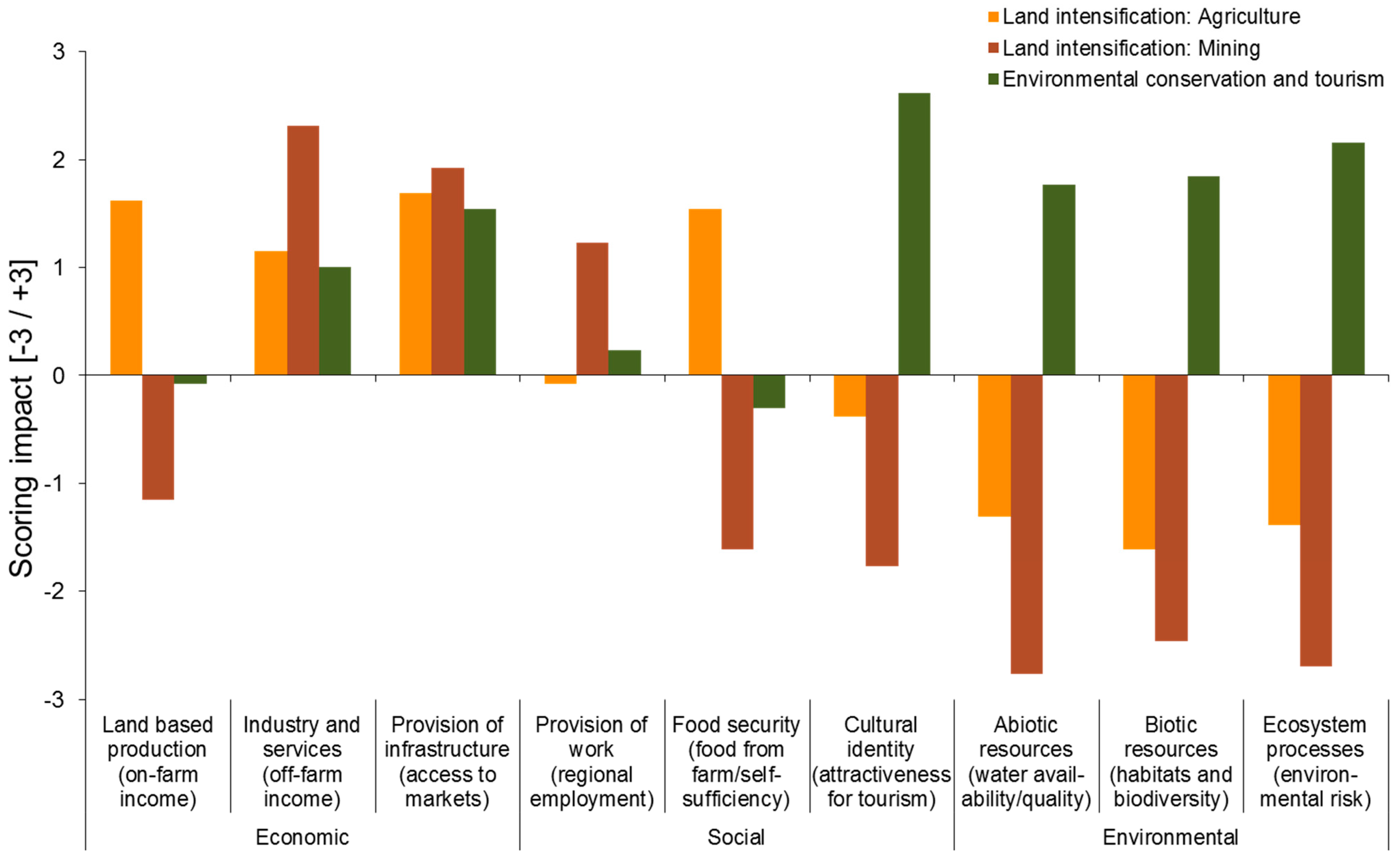
The results of the scenario assessment indicate a differentiated picture among anticipated (expert-based) scenario impacts and between the different land use functions (LUFs) being affected (Figure 2).

3.2.1.1. Scenario 1: Land Intensification: Agricultural

This scenario was expected to have positive impacts on four LUFs (1 social, 3 economic), i.e., contributing to food security, land-based production, industry and services and infrastructural development. A minor negative impact was expected for the social LUF work, culture (tourism), with increasing negative impacts on all environmental LUFs (water, biodiversity and environmental risk). Given the large amount of land available in Inner Mongolia that can be used for agricultural production to cope with the growing demand for food in China [9], a key challenge lies in the formulation and implementation of adequate agricultural management that considers the sensitivity of soils in Inner Mongolia to wind and water erosion [52].

3.2.1.2. Scenario 2: Land Intensification: Mining

This scenario was expected to have positive impacts on three LUFs (1 social, 2 economic) and negative impacts on six LUFs (2 social, 1 economic, 3 environmental). Not surprisingly, social LUFs related to food security and culture would most likely be negatively affected by the expansion of mining activities. However, the economic LUF “land based production” relative to on-farm income was expected to experience vast losses due to transport activities and related dust deposits on fields. This problem is particularly considered to be problematic in semi-arid and arid regions of Inner Mongolia [57,58].

3.2.1.3. Scenario 3: Environmental Conservation and Tourism

The “environmental conservation and tourism” scenario was expected to have positive impacts on seven LUFs (2 social, 2 economic, 3 environmental). In addition to targeted conservation strategies on environmental functions that are performing well under this scenario, it is interesting to note that cultural aspects related to tourism (tourists who enjoy grasslands and nomadic culture) were expected to benefit most. During the scenario impact assessment workshop (phase 4), some participating experts mentioned the high potential of ecotourism or cultural tourism in Inner Mongolia, which will most likely increase in the future as the result of the growing middle- and upper-income classes in China.
Figure 2. Expert-based scenario impacts on land use functions.
Sustainability 07 05027 g002

3.2.2. Assessment of Scenario Impacts (Sustainability Trade-Offs)

In the field of assessing multifunctional land use, scenario studies can serve as explorative techniques for envisaging the different potentials, risks and sustainability trade-offs [59]. An aggregated view of the scenario impacts (Figure 3), in which the perceived importance placed on multiple land use functions by stakeholders was considered with a weighing procedure (Table 3), indicated that a development-oriented intensification of land (agriculture and mining) will mainly benefit the economic dimension, while negatively affecting the social and, in particular, the environmental dimensions. In contrast, a promotion of environmental conservation programs, in combination with a promotion of the tourism sector, indicates only positive effects. However, in spite of the need for economic development and the fact that the environmental conditions in Inner Mongolia are quite fragile, policy makers need to balance all three dimensions of sustainability (economic, social and environmental) to achieve the most sustainable land use options.
Figure 3. Aggregated expert-based scenario impacts considering the perceived importance of regional land use functions by stakeholders.
Sustainability 07 05027 g003

3.3. Interdisciplinary Cooperation in Impact Assessment

In addition to generating new results, the FoPIA method also aims at fostering knowledge exchange among interdisciplinary research groups, which we understand as a process. In this regard, it is not only crucial to understand each other’s disciplinary language but also to build a common ground of trust [60,61,62]. In this study, the land use function framework was utilised to support bringing together a heterogeneous group of international researchers. Based on the LUF framework, the individual participants in the scenario impact assessment workshop (phase 4) could introduce their professional background by highlighting those LUFs about which they felt the most knowledgeable (Table 4). Thereby, it could be demonstrated that the expertise among all LUFs has been covered. It appeared that many participants had multidisciplinary backgrounds, which can be explained by the various personal backgrounds, both on the professional side (e.g., profession, academic background) and the private context (e.g., family, hobbies). The group very much appreciated this exercise while having the chance to introduce themselves as well as learning the areas of expertise of others.
Table 4. Self-reflection of participating experts (phase 4) regarding their expertise about the different land use functions.
Expert no.Land based productionIndustry and servicesProvision of infrastructureProvision of workFood securityCultural identityProvision of abiotic resourcesProvision of biotic resourcesMaintenance of ecosystem processes
1.x x xx
2.xx x x
3.xxxx
4.x xx x
5. xxx
6. xx x
7.x x
8.x xxxxx
9. x xx xx
10. x x x x
11. xxx
12. x xx x
13. x x x
SUM672576349

3.4. Policy Recommendations

A key recommendation was to improve the science-policy interface at the institutional level. This recommendation refers to better access to and more influence on decision-making for scientific knowledge, especially in regard to monitoring and assessing policy results. The panel group of the scenario impact assessment acknowledged the need to increase scientific participation and the importance of methods such as FoPIA. The emphasis on scientific advice reflects the general trend in the Chinese political system to increasingly involve scientific advice in policy-making [63].
The workshop in phase 4 also stressed that better scientific knowledge of the social, economic, and environmental land use issues in Inner Mongolia should inform policy makers. According to the recommendations, research should deepen the knowledge about the impacts of various types of land use, in particular, the impacts on water resources that were considered a key challenge in most areas of Inner Mongolia. Moreover, research should better understand the implications of land use and adaptation strategies for strengthening environmental resilience (i.e., better understanding the causal linkages between human-environmental systems). The participants also suggested examining the relationship between national and local natural resource provisions. However, in addition to the importance of scientific knowledge, the participants also proposed to give more weight to the tacit knowledge of local people such as Mongolian herders, who place a high level of experience on the environment they live in and its needs. Many of the suggestions imply not only a policy change at the local level but would also require changing the national and provincial priorities and macro-targets [64]. Consequently, the recommendations targeted the National Development and Reform Commission (NDRC) in particular, which is the major economic planning agency. Some experts claimed that the NDRC should replace its economic focus with an integrated view that considers the interrelations between various factors such as agriculture, mining, water, and the environment. Contrary to the national promotion of the extractive industry in Inner Mongolia, other workshop participants recommended limiting the extraction of minerals and coal in the region. Instead, the national and provincial governments should advance the development of renewable energies and grassland protection.
As the implications of these recommendations are quite far-reaching for current policy, the participants did not only see a need for policy change but also for institutional adaptation in politics. The critique targets two particular problems of the Chinese political system: first, the lack of coordination among government agencies. The workshop found that there should be a clarification of institutional mandates and responsibilities, as well as a cooperation mechanism for joint decision making and implementation to reduce or avoid overlapping and unclear responsibilities of the government departments and to improve the work efficiency. Second, in a study of the Chinese political system, the “implementation bias” describes the fact that local governments often significantly change the decisions of the central government when implementing these at the local level or even not implementing them at all [65]. Considering this challenge, the participants thought that the implementation of national laws and policies by local governments should be better monitored and controlled.
Finally, the participants also came up with ideas for instruments to design and implement policy. Recognising the lack of an ex-ante assessment of policy in China, they proposed to create a monitoring system for policy impact assessment, using remote sensing and information technologies, to clarify the impacts of mining and agricultural policies. In addition, to better protect the grassland, the participants say that the state should clarify the land-ownership of herders.

3.5. The Potential of FoPIA for Knowledge Brokerage (KB)

With respect to impact assessment, the scientific provision of assessment results is best incorporated into policy makers’ decisions [66]. FoPIA itself is a scientifically developed and tested method that aims at providing scientific and stakeholder knowledge for the policy process and impact assessment. Accordingly, it is one of FoPIA’s core elements to establish an interaction among scientists and policy makers. FoPIA may thus serve as an entry point for establishing the KB process and for implementing different KB elements. While scientists provide scientifically profound knowledge on which to build the assessment, policy makers are regarded as stakeholders within FoPIA who contribute to the assessment with their practical expertise on the corresponding policy area and geographic region. Thereby, the scientifically generated results can be partly in parallel or continuously reflected by policy maker expertise. Further, policy makers are, from an early stage, involved in the assessment process, which may support their understanding of the results and allows them to gain knowledge and insight that goes well beyond the pure reading of the final assessment report at the end of the assessment process. To identify and discuss the KB aspects of FoPIA, we built on Michaels’ six KB elements, as they illustrate the variety of general brokerage options that allow for a comparison with the five FoPIA phases (Table 5). Saarela et al. [39] list KB methods e.g., the identification of key experts, joint meetings of scientists and policy makers (including the introduction of new people to each other), and joint fact-finding activities as well as policy briefs.
Table 5. Knowledge Brokerage (KB) core elements (Michaels 2009; adapted by Saarela et al. [39]).
KB Core Elements
(KB 1) Informing: Disseminate key information
(KB 2) Consulting: Identify who to contact
(KB 3) Matchmaking: Seek out key experience
(KB 4) Engaging: Motivate all necessary parties to take part in the process
(KB 5) Collaborating; Jointly framed interaction process
(KB 6) Building capacity: Jointly framed interaction process with the aim of learning from doing
Table 6 provides a detailed overview of the FoPIA phases in relation to Michaels’ KB core elements.
Table 6. Knowledge brokerage elements used in FoPIA (according to Michaels [37]).
Main participants in the FoPIA phasesKB strategyKB method
FoPIA as a method in general
-
FoPIA research team
-
Researcher community
-
local and regional policy makers
(KB4) engage
-
Definition of individual FoPIA scope by FoPIA research team
FoPIA phase 1: Context analysis (scientific literature review)
-
FoPIA research team
Preparation of (KB3) matchmake (FoPIA phase 3 and 4)
-
Identification and provision of scientific knowledge to matchmake FoPIA topic with scientists
Preparation of (KB1) inform and (KB2) consult (FoPIA phases 2 and 3)
-
Identification and provision of scientific knowledge (a) to inform policy makers and scientists and (b) to provide a basis for consulting
Phase 2: Specification of the sustainability context
-
FoPIA research team as facilitator
-
Local and regional decision makers
(KB3) matchmake of policy makers with FoPIA targets in phases 2 and 3
-
Identification of policy makers as participants based on content identified in FoPIA phase 1
-
Contact and invitation of policy makers
(KB1) inform policy makers about FoPIA method and pre-defined LUFs
-
Local workshop:
  • Presentation of FoPIA method
  • Presentation of nine pre-defined LUFs
(KB2) consult policy makers’ perspective on LUFs and their local characteristics
-
Local workshop: Participants were asked to specify and weigh LUFs relevant for the region
Preparation of (KB4) engage to define scenarios and scenario assessment (FoPIA phases 3 and 4)
-
Integration of FoPIA phase 2 results from (KB2) consult into scenario assessment (FoPIA phase 4)
Phase 3: Scenario and indicator development
-
FoPIA research team as facilitator
-
Selected national and international researchers
(KB4) engage to define preliminary scenarios and scenario assessment
-
Definition of scenario narratives by FoPIA research team based on FoPIA phase
-
Suggestion LUF indicators based on previous FoPIA studies
(KB3) matchmake of scientists with preliminary scenarios
-
Identification of scientists participating in the survey
-
Contact and invitation of scientists
(KB1) inform scientists on FoPIA preliminary scenarios
-
Provision of digital information on FoPIA, scenario method, scenario outline and scenario assessment to scientists interested to participate in the survey
(KB 2) consult researchers’ perspectives on scenarios
-
Development and sending of survey questionnaire
Preparation of (KB4) engage to define scenarios and scenario assessment (FoPIA phases 3 and 4)
-
Integration of FoPIA phase 2 results from (KB2) consult into
  • scenario design (FoPIA phase 3)
  • indicator definition
  • scenario assessment (FoPIA phase 4)
Phase 4: Scenario impact assessment and trade-off analysis
-
FoPIA research team as facilitator
-
Invited international researchers
(KB4) engage to define final scenarios
-
Introduction of scenarios by FoPIA research team based on FoPIA phases 1 and 3
-
Verification of scenario assumptions during assessment workshop by participating expert panel
(KB3) matchmake scientists and policy makers with scenarios
-
Identification of scenario expert scientists
-
Contact and invitation of expert scientists
(KB1) inform on FoPIA
-
Inform participants on FoPIA, scenarios and assessment
(KB2) consult on scenarios
-
Scientists conducted indicator-based scenario impact assessment
(KB2) consult on policy recommendations
-
Scientists provided policy recommendations
Phase 5: Dissemination of results
-
FoPIA research team as facilitator
-
policy makers
-
international researchers
(KB2) consult request feedback on results of FoPIA phase 4
-
Plausibility check of policy recommendations with scientists and policy makers involved in phases 2 and 4
(KB1) inform policy makers on FoPIA results
-
Development and distribution of international policy brief
The general FoPIA method as a participatory assessment instrument was particularly based on (KB4) engaging, as it aims at motivating all involved parties (scientists, policy makers and possibly further stakeholders) to participate in the individual assessment phases [32]. As a systematic evaluation and presentation of expert panel results is relevant in policy impact assessment [67], FoPIA has followed a specific structure that was now extended by means of this study.
However, during all FoPIA phases, policy makers and scientists did not interact directly or on a personal level, but the phases are usually dedicated exclusively to policy makers (phase 2) or scientists (phases 1, 3 and 4). Thereby, the information identified in the previous phases formed the basis for the following phases and was presented to the new expert group in the following phase. In dissemination phase 5, scientists and policy makers were both providing their comments in the same phase, yet again did not interact directly. Thus, in sum, FoPIA presents a strong, yet indirect, pattern of cooperation among scientists and policy makers during almost all phases.
Within the five individual FoPIA phases, the particular focus was on KB elements 1 to 4. In phases 2 to 5, the experts were identified based on their expertise corresponding to land use changes in Inner Mongolia (KB4 engaging), a relevant element in panel composition also identified by Noble [67]. They were then motivated to participate in the workshops and the survey (KB3 matchmaking), a KB activity that was regarded as central in the FoPIA process in their comparison of six knowledge brokerage cases [39]. Further, the experts were invited to provide their expertise to the corresponding activities (KB2 consulting).
Thus, in phases 2 to 4, the participants were directly or indirectly informed of the results of all or some previous FoPIA phases and thus extended their individual knowledge on land use changes in Inner Mongolia. Further, the FoPIA research team introduced the FoPIA method to the scientists and policy makers (KB1 informing, according to Michaels [37]). Thus, the participants received additional information about a participatory impact assessment method that was new to them and gained personal expertise by participating in it. Although experience with assessment systems may be one of the reasons for inviting a person in an expert role for a participatory assessment [67], the main reason for the invitation to FoPIA participation was personal expertise on land use questions and changes in Inner Mongolia.
(KB6) capacity building is indirectly mentioned, as building capacity can be seen as having strong overlaps with (KB1) informing on the participants on the FoPIA method and on land use changes in Inner Mongolia, as well as with the participation as stakeholders in the FoPIA. Similar approaches are described by Fazey et al. [15], focusing on knowledge exchange or knowledge sharing to provide information to the interested involved parties. This activity also implied a possible transformation of knowledge for the different participants, particularly through the research team that served as facilitator throughout the entire FoPIA process [15]. FoPIA can thereby be regarded as an instrument that indirectly builds the capacity of the participating stakeholders, thereby possibly enabling the knowledge being taken up in future and further policy processes.
The strength of (KB5) collaboration within FoPIA could be seen from two positions. With respect to the strong interaction of the FoPIA research team, this aspect could be regarded as one of FoPIA’s key KB activities [39]. In contrast, when looking at the direct interaction of stakeholders and research experts throughout the entire FoPIA process, it could also be identified as the weakest KB aspect in FoPIA. As the stakeholders and scientists did generally not participate in the same phase (only in phase 5 in parallel) and did not interact personally, a direct interaction could not be established. Collaboration [37] and, in a wider sense, the co-production of knowledge [15] are regarded as relevant elements but are less included in the present setting of FoPIA.
For future FoPIA, it would be valuable to consider how a stronger and more direct interaction among policy makers and scientists could be established. Further, this could be relevant with respect to the joint framing of research and policy-relevant FoPIA questions.
Despite the missing direct interaction, we regard the current five-phase structure of FoPIA and the actual implementation of each of these phases as a strong support to KB. Applying the FoPIA already allows policy makers to benefit from scientific expertise that was specifically requested for the local needs of the policy makers (in phase 2). This benefit was strongly supported by integrating the two new phases into the original FoPIA concept. Phase 1 “context analysis/literature review” allowed for a deeper analysis of the local and regional context, thereby offering a broader knowledge to base the scenario development on (particularly for phase 3). Furthermore, phase 5 “formulation of policy recommendations,” summarises the key results of the FoPIA in a format targeted specifically at policy makers. Furthermore, the advantage of incorporating a dissemination phase into FoPIA was confirmed by reflecting the five FoPIA phases in the light of the KB concept. Though dissemination methods as policy briefs have already become an established element in research processes, this phase had previously not been a steady part of FoPIA. In summary, the KB focus emphasised the relevance of the FoPIA with respect to bridging the gap between science and policy.

4. Conclusions

4.1. Key Findings from the Case Study

As for the scenario assessment, the “Land intensification: Agriculture” and “Land intensification: Mining” scenarios were found to have mainly negative environmental and social effects and positive economic effects, while the “Environmental conservation and tourism” scenario was found to positively affect all three sustainability dimensions. Nevertheless, in spite of the need for economic development and the fact that the environmental conditions in Inner Mongolia are quite fragile, policy makers need to balance all three dimensions of sustainability (economic, social and environmental) to achieve the most sustainable land use options. The expert panel of the scenario assessment stressed the need to improve the science-policy interface and available monitoring systems. For example, there appeared to be a gap between policy design (i.e., land conversion) and policy implementation (spatial targeting) mechanisms, which could be optimized by installing appropriate monitoring systems (e.g., remote sensing).

4.2. Lessons Learned from Extending the FoPIA Method

In this study, the traditional three-phase FoPIA approach after König et al. [33] was expanded to a five-phase approach involving (1) a new context analysis phase; (2) sustainability context specification; (3) scenario and indicator development; (4) impact assessment (weighted and non-weighted); and (5) a new policy recommendation formulation phase.
In examining the FoPIA as a method, three key findings emerged.
  • First, discrepancies between research knowledge (phase 1) and local stakeholder needs (phase 2) were identified while reflecting on the first two phases. These two phases generate a richer scientific basis for the development of a local sustainability FoPIA context. The discrepancies between international research result availability and local stakeholder needs identified in these phases highlight a need for stronger local policy maker involvement during the development of research designs relevant to Inner Mongolia.
  • Second, the new final phase (phase 5) of policy recommendations addressed not only local policy makers but also national policy makers. In promoting constant collaboration between scientists and policy makers during the various phases, the extended FoPIA approach creates opportunities to intensify knowledge brokerage at the science-policy interface.
  • Third, discussing the findings with stakeholders before disseminating the results was viewed positively by the researchers and policy makers. This approach allowed the participants to affect the final results in addition to the strictly intermediate phases (2, 3, 4) that they were originally involved in.
Thus, while we conclude that the FoPIA results of this study do not serve as empirical evidence, they do serve as a supporting tool towards the identification of region-specific land use problems and verification of causal relationships between policy actions, land use decisions and selected sustainability indicators.
With regard to the KB function of FoPIA, assessments of the methodological phases show that FoPIA primarily serves to establish the KB process and that the framework especially benefits from early evaluations of scientific results by policy makers. We conclude that FoPIA again proved to serve as a sound method of policy assessment. Further, we found that FoPIA fostered knowledge brokerage, thus increasing the political uptake of scientific results. Therefore, the use of FoPIA may promote the inclusion of scientific assessment results in policy-making processes.

Acknowledgments

The paper is part of the research project LIAISE (Linking Impact Assessment to Sustainability Expertise, www.liaise- noe.eu) funded by Framework Programme 7 of the European Commission. Support from National Key Project for Basic Research (2014CB954302) is appreciated. We thank the various researchers for their support and the policy makers who participated in the scenario questionnaire and the workshops as well as Tarja Söderman and Sanna-Riikka Saarela (Finnish Environment Institute), Amjath Babu (ZALF) and the reviewers for their valuable remarks.

Author Contributions

All authors of this paper have worked collaboratively since 2013 on the LIAISE research project “Test case: Land management in Inner Mongolia, China”, which was funded by the European Commission. All authors have reviewed and commented on this manuscript.

Conflicts of Interest

The authors declare no conflict of interest.

References

  1. Zhang, X.P.; Cheng, X.M. Energy consumption, carbon emissions, and economic growth in China. Ecol. Econ. 2009, 68, 2706–2712. [Google Scholar] [CrossRef]
  2. Zhang, K.; Wen, Z. Review and challenges of policies of environmental protection and sustainable development in China. J. Environ. Manag. 2008, 88, 1249–1261. [Google Scholar] [CrossRef]
  3. Zhang, M.A.; Borjigin, E.; Zhang, H. Mongolian nomadic culture and ecological culture: On the ecological reconstruction in the agro-pastoral mosaic zone in Northern China. Ecol. Econ. 2007, 62, 19–26. [Google Scholar] [CrossRef]
  4. Lin, G.C.S.; Ho, S.P.S. China’s land resources and land-use change: Insights from the 1996 land survey. Land Use Policy 2003, 20, 87–107. [Google Scholar] [CrossRef]
  5. Wübbeke, J. Rare earth elements in China: Policies and narratives of reinventing an industry. Resour. Policy 2013, 38, 384–394. [Google Scholar] [CrossRef]
  6. Hoffmann, C.; Funk, R.; Reiche, M.; Li, Y. Assessment of extreme wind erosion and its impacts in Inner Mongolia, China. Aeolian Res. 2011, 3, 343–351. [Google Scholar] [CrossRef]
  7. Ding, C. Land policy reform in China: Assessment and prospects. Land Use Policy 2003, 20, 109–120. [Google Scholar] [CrossRef]
  8. Xu, J.; Yin, R.; Li, Z.; Liu, C. China’s ecological rehabilitation: Unprecedented efforts, dramatic impacts, and requisite policies. Ecol. Econ. 2006, 57, 595–607. [Google Scholar] [CrossRef]
  9. Du, B.; Zhen, L.; de Groot, R.; Goulden, C.E.; Long, X.; Cao, X.; Wu, R.; Sun, C. Changing patterns of basic household consumption in the Inner Mongolian grasslands: A case study of policy-oriented adoptive changes in the use of grasslands. Rangel. J. 2014, 36, 505–517. [Google Scholar] [CrossRef]
  10. Zhen, L.; Li, F.; Yan, H.M.; Liu, G.H.; Liu, J.Y.; Zhang, H.Y.; Du, B.Z.; Wu, R.Z.; Sun, C.Z.; Wang, C. Herders’ willingness to accept versus the public sector’s willingness to pay for grassland restoration in the Xilingol League of Inner Mongolia, China. Environ. Res. Lett. 2014, 9. [Google Scholar] [CrossRef]
  11. Yin, R.S.; Yin, G.P. China’s primary programs of terrestrial ecosystem restoration: Initiation, implementation, and challenges. Environ. Manag. 2010, 45, 429–441. [Google Scholar] [CrossRef]
  12. Tong, C.; Wu, J.; Yong, S.; Yang, J.; Yong, W. A landscape-scale assessment of steppe degradation in the Xilin River Basin, Inner Mongolia, China. J. Arid Environ. 2004, 59, 133–149. [Google Scholar] [CrossRef]
  13. Dearing, J.A.; Battarbee, R.W.; Dikau, R.; Larocque, I.; Oldfield, F. Human-environment interactions: Learning from the past. Reg. Environ. Change 2006, 6, 1–16. [Google Scholar] [CrossRef]
  14. Rounsevell, M.D.A.; Pedroli, B.; Erb, K.H.; Gramberger, M.; Busck, A.G.; Haberl, H.; Kristensen, S.; Kuemmerle, T.; Lavorel, S.; Lindner, M.; et al. Challenges for land system science. Land Use Policy 2012, 29, 899–910. [Google Scholar] [CrossRef]
  15. Fazey, I.; Evely, A.C.; Reed, M.S.; Stringer, L.C.; Kruijsen, J.; White, P.C.L.; Newsham, A.; Jin, L.; Cortazzi, M.; Phillipson, J.; et al. Knowledge exchange: A review and research agenda for environmental management. Environ. Conserv. 2013, 40, 19–36. [Google Scholar] [CrossRef]
  16. Fraser, E.D.G.; Dougill, A.J.; Mabee, W.E.; Reed, M.; McAlpine, P. Bottom up and top down: Analysis of participatory processes for sustainability indicator identification as a pathway to community empowerment and sustainable environmental management. J. Environ. Manag. 2006, 78, 114–127. [Google Scholar] [CrossRef]
  17. Reed, M.S.; Fraser, E.D.G.; Dougill, A.J. An adaptive learning process for developing and applying sustainability indicators with local communities. Ecol. Econ. 2006, 59, 406–418. [Google Scholar] [CrossRef]
  18. Stringer, L.C.; Dougill, A.J.; Fraser, E.; Hubacek, K.; Prell, C.; Reed, M.S. Unpacking “participation” in the adaptive management of social ecological systems: A critical review. Ecol. Soc. 2006, 11, 719. [Google Scholar]
  19. Podhora, A.; Helming, K.; Adenäuer, L.; Heckelei, T.; Kautto, P.; Reidsma, P.; Rennings, K.; Turnpenny, J.; Jansen, J. The policy-relevancy of impact assessment tools: Evaluating nine years of European research funding. Environ. Sci. Policy 2013, 31, 85–95. [Google Scholar] [CrossRef]
  20. Helming, K.; Diehl, K.; Bach, H.; Dilly, O.; König, B.; Kuhlman, T.; Pérez-Soba, M.; Sieber, S.; Tabbush, P.; Tscherning, K.; et al. Ex ante impact assessment of policies affecting land use, part A: Analytical framework. Ecol. Soc. 2011, 16, 27–43. [Google Scholar]
  21. Hacking, T.; Guthrie, P. A framework for clarifying the meaning of triple bottom-line, integrated, and sustainability assessment. Environ. Impact Assess. Rev. 2008, 28, 73–89. [Google Scholar] [CrossRef]
  22. König, H.J.; Podhora, A.; Helming, K.; Zhen, L.; Wang, C.; Wübbeke, J.; Baumeister, T.; Du, B.; Yan, H. Confronting international research topics with stakeholders on multifunctional land use: the case of Inner Mongolia, China. iForest Biogeosci. For. 2014, 7, 403–413. [Google Scholar] [CrossRef]
  23. Jiang, L.; Deng, X.; Seto, K.C. The impact of urban expansion on agricultural land use intensity in China. Land Use Policy 2013, 35, 33–39. [Google Scholar] [CrossRef]
  24. Castella, J.C.; Kam, S.P.; Quang, D.D.; Verburg, P.H.; Hoanh, C.T. Combining top-down and, bottom-up modelling approaches of land use/cover change to support public policies: Application to sustainable management of natural resources in northern Vietnam. Land Use Policy 2007, 24, 531–545. [Google Scholar] [CrossRef]
  25. McNeill, D.; Nesheim, I.; Brouwer, F. Land Use Policies for Sustainable Development: Exploring Integrated Assessment Approaches; Edward Elgar Publishing: Cheltenham, UK, 2012. [Google Scholar]
  26. Uthes, S.; Fricke, K.; König, H.; Zander, P.; van Ittersum, M.; Sieber, S.; Helming, K.; Piorr, A.; Müller, K. Policy relevance of three integrated assessment tools - A comparison with specific reference to agricultural policies. Ecol. Modell. 2010, 221, 2136–2152. [Google Scholar] [CrossRef]
  27. Van Ittersum, M.K.; Ewert, F.; Heckelei, T.; Wery, J.; Olsson, J.A.; Andersen, E.; Bezlepkina, I.; Brouwer, F.; Donatelli, M.; Flichman, G.; et al. Integrated assessment of agricultural systems—A component-based framework for the European Union (SEAMLESS). Agric. Syst. 2008, 96, 150–165. [Google Scholar] [CrossRef]
  28. Reed, M.S. Stakeholder participation for environmental management: A literature review. Biol. Conserv. 2008, 141, 2417–2431. [Google Scholar] [CrossRef]
  29. Morris, J.; Tassone, V.; De Groot, R.; Camilleri, M.; Moncada, S. A framework for participatory impact assessment (FoPIA): Involving stakeholders in European policy-making, a case study of land use change in Malta. Ecol. Soc. 2011, 16. Article 12. [Google Scholar]
  30. Sieber, S.; Amjath-Babu, T.S.; McIntosh, B.S.; Tscherning, K.; Müller, K.; Helming, K.; Pohle, D.; Fricke, K.; Verweij, P.; Pacini, C.; et al. Evaluating the characteristics of a non-standardised Model Requirements Analysis (MRA) for the development of policy impact assessment tools. Environ. Modell. Softw. 2013, 49, 53–63. [Google Scholar] [CrossRef]
  31. Graef, F.; Sieber, S.; Mutabazi, K.; Asch, F.; Biesalski, H.K.; Bitegeko, J.; Bokelmann, W.; Bruentrup, M.; Dietrich, O.; Elly, N.; et al. Framework for participatory food security research in rural food value chains. Glob. Food Sec. 2014, 3, 8–15. [Google Scholar] [CrossRef]
  32. König, H.J.; Sghaier, M.; Schuler, J.; Abdeladhim, M.; Helming, K.; Tonneau, J.P.; Ounalli, N.; Imbernon, J.; Morris, J.; Wiggering, H. Participatory impact assessment of soil and water conservation scenarios in Oum Zessar Watershed, Tunisia. Environ. Manag. 2012, 50, 153–165. [Google Scholar] [CrossRef]
  33. König, H.J.; Schuler, J.; Suarma, U.; McNeill, D.; Imbernon, J.; Damayanti, F.; Dalimunthe, S.A.; Uthes, S.; Sartohadi, J.; Helming, K.; et al. Assessing the impact of land use policy on urban-rural sustainability using the FoPIA approach in Yogyakarta, Indonesia. Sustainability 2010, 2, 1991–2009. [Google Scholar] [CrossRef] [Green Version]
  34. König, H.J.; Uthes, S.; Schuler, J.; Zhen, L.; Purushothaman, S.; Suarma, U.; Sghaier, M.; Makokha, S.; Helming, K.; Sieber, S.; et al. Regional impact assessment of land use scenarios in developing countries using the FoPIA approach: Findings from five case studies. J. Environ. Manag. 2013, 127, S56–S64. [Google Scholar] [CrossRef]
  35. Purushothaman, S.; Patil, S.; Francis, I.; König, H.J.; Reidsma, P.; Hegde, S. Participatory impact assessment of agricultural practices using the land use functions framework: Case study from India. Int. J. Biodivers. Sci. Ecosyst. Serv. Manag. 2013, 9, 2–12. [Google Scholar] [CrossRef]
  36. Thiel, A. The use of ex-ante modelling tools in European Impact Assessment: What role does land use play? Land Use Policy 2009, 26, 1138–1148. [Google Scholar] [CrossRef]
  37. Michaels, S. Matching knowledge brokering strategies to environmental policy problems and settings. Environ. Sci. Policy 2009, 12, 994–1011. [Google Scholar] [CrossRef]
  38. Adelle, C. Contexualising the tool development process through a knowledge brokering approach: The case of climate change adaptation and agriculture. Environ. Sci. Policy 2014, in press. [Google Scholar]
  39. Saarela, S.R.; Söderman, T.; Lyytimäki, J. Knowledge brokerage context factors—What matters in knowledge exchange in impact assessment? Environ. Sci. Policy 2014, in press. [Google Scholar]
  40. Yu, F.; Price, K.P.; Ellis, J.; Shi, P. Response of seasonal vegetation development to climatic variations in eastern central Asia. Remote Sens. Environ. 2003, 87, 42–54. [Google Scholar] [CrossRef]
  41. Costanza, R.; Daly, H.E. Natural Capital and Sustainable Development. Conserv. Biol. 1992, 6, 37–46. [Google Scholar] [CrossRef]
  42. Pérez-Soba, M.; Petit, S.; Jones, L.; Bertrand, N.; Briquel, V.; Omodei-Zorini, L.; Contini, C.; Helming, K.; Farrington, J.H.; Mossello, M.T.; et al. Land use functions—A multifunctionality approach to assess the impact of land use changes on land use sustainability. In Sustainability Impact Assessment of Land Use Changes; Helming, K., Pérez-Soba, M., Tabbush, P., Eds.; Springer: Berlin-Heidelberg, Germany, 2008; pp. 375–404. [Google Scholar]
  43. Schößer, B.; Helming, K.; Wiggering, H. Assessing land use change impacts—A comparison of the SENSOR land use function approach with other frameworks. J. Land Use Sci. 2010, 5, 159–178. [Google Scholar] [CrossRef]
  44. United Nations. Our Common Future, Chapter 2: Towards Sustainable Development; United Nations: Geneva, Switzerland, 1987. [Google Scholar]
  45. König, H.J. Operationalising Sustainability Impact Assessment of Land Use Scenarios in Developing Countries: A Stakeholder-Based Approach with Case Studies in China, India, Indonesia, Kenya, and Tunisia. Ph.D. Thesis, University of Potsdam, Potsdam, Germany, 2013. [Google Scholar]
  46. Reidsma, P.; König, H.; Feng, S.; Bezlepkina, I.; Nesheim, I.; Bonin, M.; Sghaier, M.; Purushothaman, S.; Sieber, S.; van Ittersum, M.K.; et al. Methods and tools for integrated assessment of land use policies on sustainable development in developing countries. Land Use Policy 2011, 28, 604–617. [Google Scholar] [CrossRef]
  47. Paracchini, M.L.; Pacini, C.; Jones, M.L.M.; Perez-Soba, M. An aggregation framework to link indicators associated with multifunctional land use to the stakeholder evaluation of policy options. Ecol. Indic. 2011, 11, 71–80. [Google Scholar] [CrossRef]
  48. Reed, M.S.; Kenter, J.; Bonn, A.; Broad, K.; Burt, T.P.; Fazey, I.R.; Fraser, E.D.G.; Hubacek, K.; Nainggolan, D.; Quinn, C.H.; et al. Participatory scenario development for environmental management: A methodological framework illustrated with experience from the UK uplands. J. Environ. Manag. 2013, 128, 345–362. [Google Scholar] [CrossRef]
  49. Huang, J.; Wang, X.; Zhi, H.; Huang, Z.; Rozelle, S. Subsidies and distortions in China’s agriculture: Evidence from producer-level data. Aust. J. Agric. Resour. Econ. 2011, 55, 53–71. [Google Scholar] [CrossRef]
  50. Rozelle, S.; Taylor, J.E.; DeBrauw, A. Migration, remittances, and agricultural productivity in China. Am. Econ Rev. 1999, 89, 287–291. [Google Scholar] [CrossRef]
  51. Farrington, J.H. The new narrative of accessibility: Its potential contribution to discourses in (transport) geography. J. Transp. Geogr. 2007, 15, 319–330. [Google Scholar] [CrossRef]
  52. Reiche, M.; Funk, R.; Zhang, Z.; Hoffmann, C.; Reiche, J.; Wehrhan, M.; Li, Y.; Sommer, M. Application of satellite remote sensing for mapping wind erosion risk and dust emission-deposition in Inner Mongolia grassland, China. Grassland Sci. 2012, 58, 8–19. [Google Scholar] [CrossRef]
  53. Smedley, P.L.; Zhang, M.; Zhang, G.; Luo, Z. Mobilisation of arsenic and other trace elements in fluviolacustrine aquifers of the Huhhot Basin, Inner Mongolia. Appl. Geochem. 2003, 18, 1453–1477. [Google Scholar] [CrossRef]
  54. Van Gossum, P.; Luyssaert, S.; Serbruyns, I.; Mortier, F. Forest groups as support to private forest owners in developing close-to-nature management. For. Policy Econ. 2005, 7, 589–601. [Google Scholar] [CrossRef]
  55. Lin, Y.; Han, G.; Zhao, M.; Chang, S.X. Spatial vegetation patterns as early signs of desertification: A case study of a desert steppe in Inner Mongolia, China. Landsc. Ecol. 2010, 25, 1519–1527. [Google Scholar] [CrossRef]
  56. He, J.; Kuhn, N.J.; Zhang, X.M.; Zhang, X.R.; Li, H.W. Effects of 10 years of conservation tillage on soil properties and productivity in the farming-pastoral ecotone of Inner Mongolia, China. Soil Use Manag. 2009, 25, 201–209. [Google Scholar] [CrossRef]
  57. Dai, G.S.; Ulgiati, S.; Zhang, Y.S.; Yu, B.H.; Kang, M.Y.; Jin, Y.; Dong, X.B.; Zhang, X.S. The false promises of coal exploitation: How mining affects herdsmen well-being in the grassland ecosystems of Inner Mongolia. Energy Policy 2014, 67, 146–153. [Google Scholar] [CrossRef]
  58. Wang, C.; Ducruet, C. Transport corridors and regional balance in China: The case of coal trade and logistics. J. Transp. Geogr. 2014, 40, 3–16. [Google Scholar] [CrossRef]
  59. Brown, I.; Castellazzi, M. Scenario analysis for regional decision-making on sustainable multifunctional land uses. Reg. Environ. Change 2014, 14, 1357–1371. [Google Scholar] [CrossRef]
  60. Bracken, L.J.; Oughton, E.A. “What do you mean?” The importance of language in developing interdisciplinary research. Trans. Inst. Br. Geogr. 2006, 31, 371–382. [Google Scholar] [CrossRef]
  61. Campbell, L.M. Overcoming obstacles to interdisciplinary research. Conserv. Biol. 2005, 19, 574–577. [Google Scholar] [CrossRef]
  62. Jones, N.A.; Ross, H.; Lynam, T.; Perez, P.; Leitch, A. Mental models: An interdisciplinary synthesis of theory and methods. Ecol. Soc. 2011, 16, 46. [Google Scholar]
  63. Wübbeke, J. China’s climate change expert community—Principles, mechanisms and influence. J. Contemp. China 2013, 22, 712–731. [Google Scholar] [CrossRef]
  64. Fan, C.C.; Sun, M. Regional inequality in China, 1978–2006. Eurasian Geogr. Econ. 2008, 49, 1–20. [Google Scholar] [CrossRef]
  65. Göbel, C. Uneven policy implementation in rural China. China J. 2011, 65, 53–76. [Google Scholar]
  66. Sheate, W.R.; Partidário, M.R. Strategic approaches and assessment techniques—Potential for knowledge brokerage towards sustainability. Environ. Impact Assess. Rev. 2010, 30, 278–288. [Google Scholar] [CrossRef]
  67. Noble, B.F. Strategic environmental assessment quality assurance: Evaluating and improving the consistency of judgments in assessment panels. Environ. Impact Assess. Rev. 2004, 24, 3–25. [Google Scholar] [CrossRef]

