
Assessment of Ecological Vulnerability under Oil Spill Stress

Abstract
:1. Introduction
2. Methods
2.1. Definition of Vulnerability
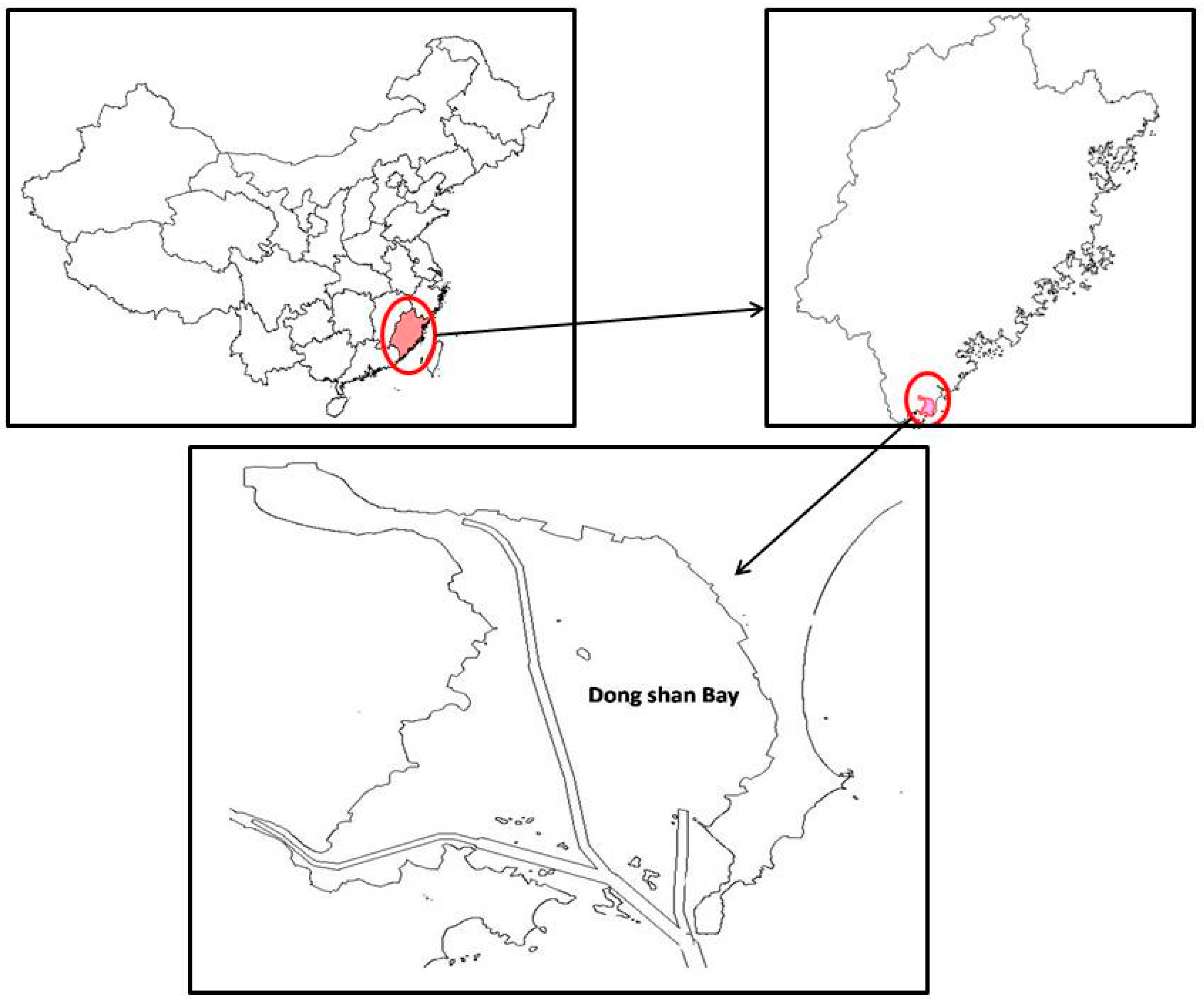
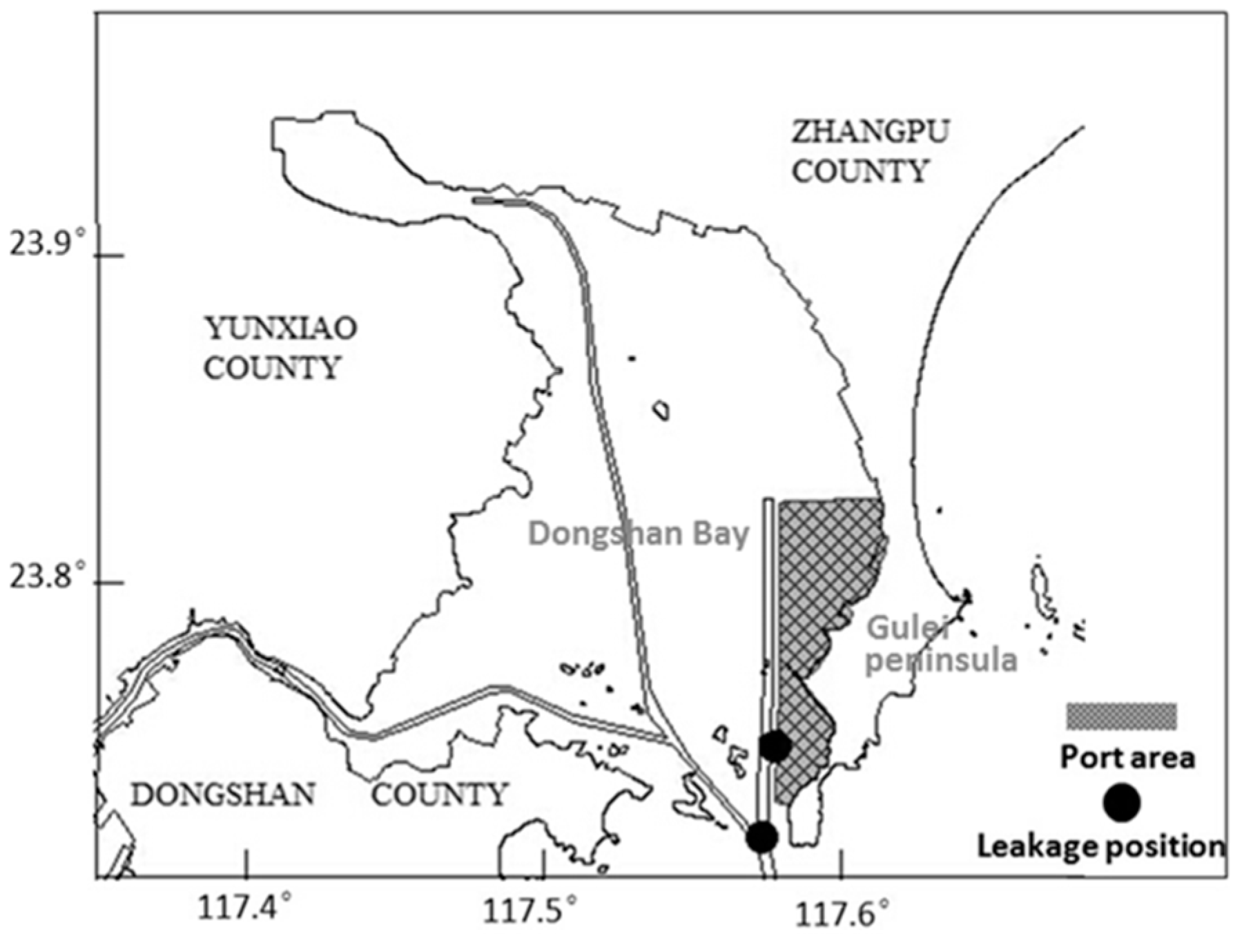
2.2. Study Area
2.3. Construction of Index System

| Target Layer | Guideline Layer | Index Layer | Selected Index Layer | |
|---|---|---|---|---|
| A Stress vulnerability | Structural vulnerability | B1 Sensitivity | C1 Ecological value | D1 Level of protected species |
| D2 Nature reserve rating | ||||
| C2 Socio-economic value | D3 Breeding industry | |||
| D4 Port operations | ||||
| D5 Tourism recreation area | ||||
| D6 Water intake | ||||
| B2 Adaptive capability | C3 Policy intervention capability | D7 Traffic convenience | ||
| D8 Difficulty in cleaning | ||||
| C4 Self-purification capacity | D9 Slope | |||
| D10 Trend | ||||
| D11 Wave direction and the angle between the coast | ||||
| D12 Bending | ||||
| B3 Exposure | C5 Simulation of oil dispersion | D13 Simulated pollution concentration in evaluation unit | ||
2.4. Division of Evaluation Unit
2.5. Index Assignment
2.6. Determination of Index Weight
| Target Layer 1 | Target Layer 2 | Index Layer and Weight | Assignment Standard | ||||
|---|---|---|---|---|---|---|---|
| 0 | 1 | 3 | 5 | 7 | |||
| Evaluation index system of stress vulnerability | Evaluation index system of structural vulnerability | D1 Level of protected species (0.234375) | Non-protected species | Regional protected species | Other national and provincial protected species | Second grade state protected species | First grade state protected species |
| D2Nature reserve rating (0.078125) | General ecologically sensitive areas | Important ecologically sensitive areas | Special ecologically sensitive areas | ||||
| D3 Breeding industry(area ratio) (0.046875) | 0–0.093 | 0.094–0.190 | 0.191–0.424 | 0.425–0.521 | >0.521 | ||
| D4 Port transportation (10000 tons)(0.009375) | None | 1–1000 | 1000–3000 | 3000–6000 | >6000 | ||
| D5 Tourism recreation area (0.046875) | None | Near-shore historical and cultural scenic spot | Waterfront parks, recreation beach | Public swimming beach water sports and entertainment area | |||
| D6 Water intake (0.084375) | None | General industrial water intake | Aquaculture water intake | Cooling water intake | Drinking water source intake | ||
| D7 Traffic convenience (within 1 km) (0.02955) | State Road | Highway | County road | Township road | Unreachable | ||
| D8 Type of coast (0.08865) | Bedrock, breakwater | Rocks, artificial simple revetment | Sand, gravel sediment | Beach sediment | Wetlands, mangroves | ||
| D9 Slope (0.003498) | >5° | 1°–5° | <1° | ||||
| D10 Tidal velocity(m/s) (0.011448) | >0.8 m/s | 0.6–0.8 s | 0.4–0.6 | 0.2–0.4 | 0–0.2 m/s | ||
| D11 direction of coastal line (0.008904) | Toward the wave propagation direction SW–ENE | Other directions | Deviate from the direction of wave propagation SW–ENE | ||||
| D12 Bending (0.00795) | 1–1.128 | 1.129–1.246 | 1.247–1.486 | 1.486–1.771 | >1.771 | ||
| D13 Concentration of simulated pollution (0.35) | <5 g/m2 | 5–50 g/m2 | 50–100 g/m2 | 100–500 g/m2 | >500 g/m2 | ||
2.7. Comprehensive Assessment of Ecological Vulnerability
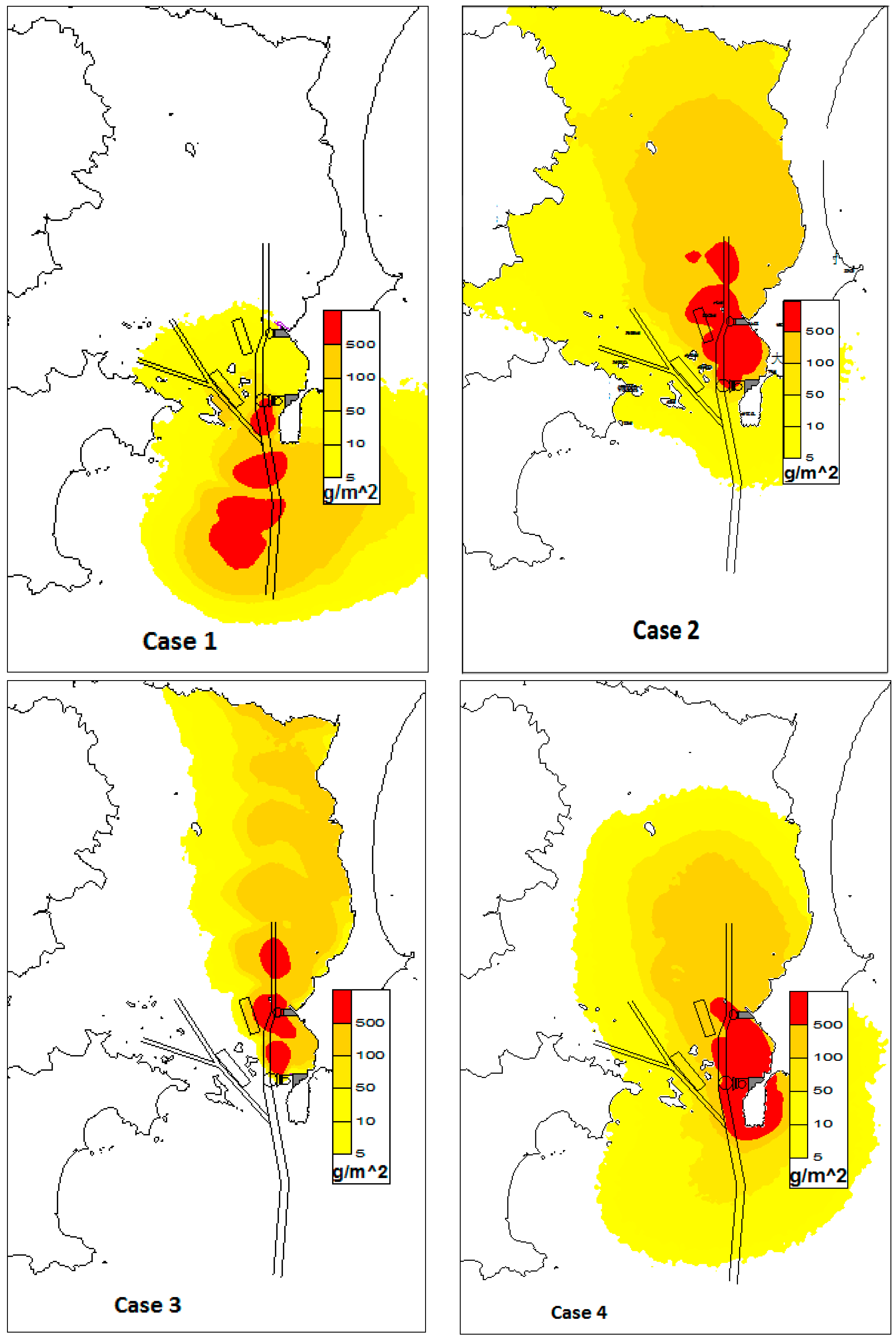
2.8. Oil Spill Simulation

| Case | Leakage Position | Time of Leakage Occurrence | Duration of Simulation | Wind |
|---|---|---|---|---|
| 1 | Front area of the wharf | During high-tide | 12 h | Perennial leading wind from NE direction with average wind speed 7.5 m/s |
| 2 | Front area of the wharf | During low tide | 24 h | Summer leading wind from SSE direction with average wind speed 3.1 m/s |
| 3 | Front area of the wharf | During low tide | 12 h | S directional wind, and the maximum wind speed allowed for operation is 14 m/s |
| 4 | Junction of waterways | During low tide | 12 h | Summer leading wind from SSE direction with average wind speed 3.1 m/s |
3. Results
3.1. Oil Spill Simulation Results
3.2. Vulnerability Evaluation Results
| Categories | Ecological Vulnerability Index | ||||
|---|---|---|---|---|---|
| Non-Vulnerable Region | Slightly Vulnerable Region | Moderately-Vulnerable Region | Vulnerable Region | Extremely Vulnerable Region | |
| Structural vulnerability | 0–0.46 | 0.46–1.00 | 1.00–2.02 | 2.02–3.07 | >3.07 |
| Stress vulnerability | 0–0.66 | 0.66–1.22 | 1.22–2.02 | 2.02–3.07 | >3.07 |
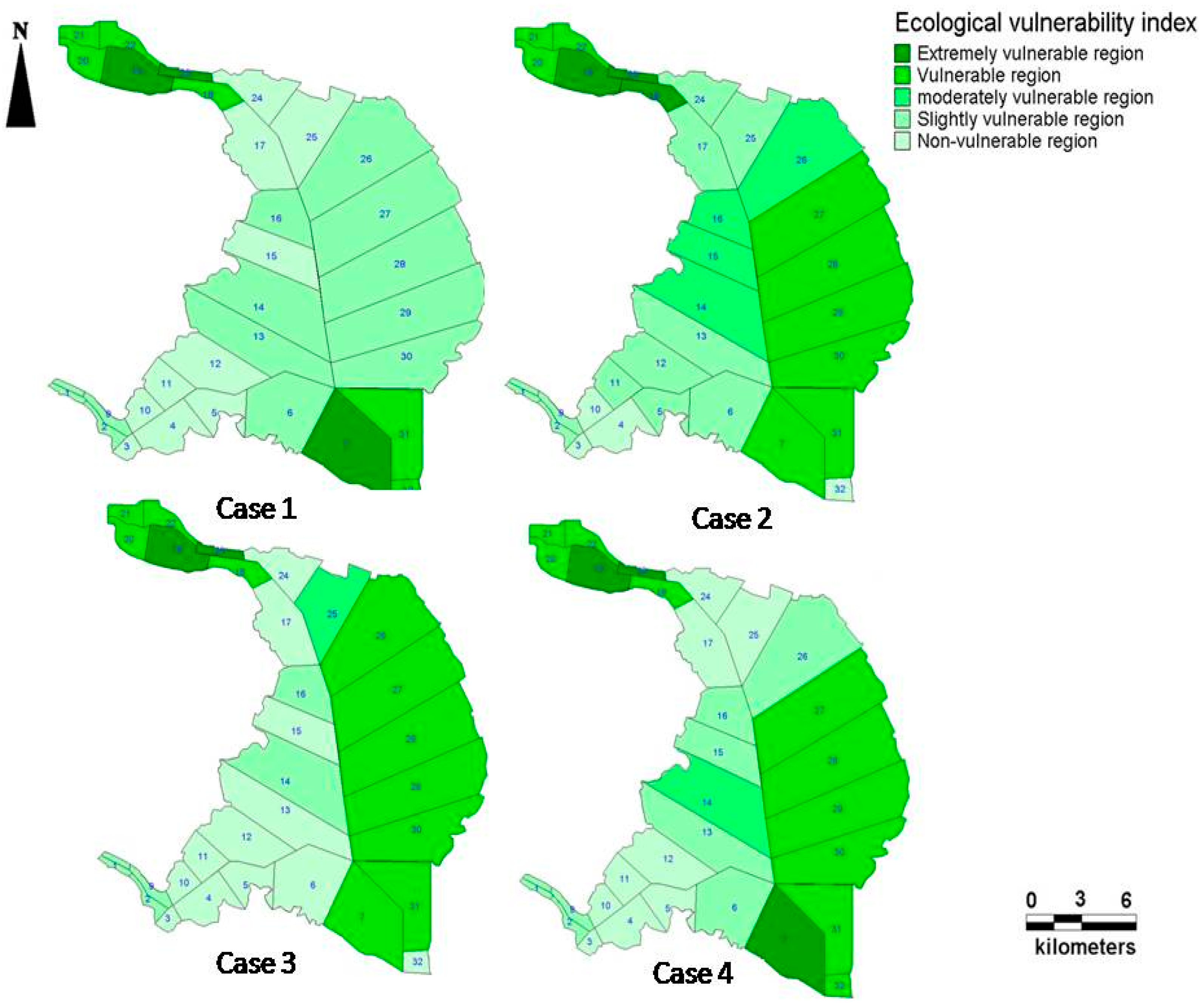
4. Discussions
Acknowledgments
Author Contributions
Conflict of Interest
References
- Van de Wiel, G.; van Drop, J.R. An oil outflow model for tanker collisions and groundings. Ann. Oper. Res. 2011, 187, 279–304. [Google Scholar] [CrossRef]
- Gundlach, E.R.; Hayes, M.O. Vulnerability of coastal environments to oil spill impacts. Mar. Technol. Soc. J. 1978, 12, 18–27. [Google Scholar]
- Hanna, R.G.M. An approach to evaluate the application of the vulnerability index for oil spills in tropical Red Sea environments. Spill Sci. Technol. Bull. 1995, 2, 171–186. [Google Scholar] [CrossRef]
- Fisher, B.; Bellman, C.; Ellis, J. The development of a spatiotemporal environmental sensitivity index using GIS. Reef. Res. 1997, 7, 3–4. [Google Scholar]
- Michel, J.; Hayes, M.O.; Dahlin, J.A.; Barton, K. Sensitivity Mapping of Inland Areas: Technical Support to the Inland Area Planning Committee Working Group USEPA Region 5; Hazardous Response and Assessment Division of NOAA: Seattle, WA, USA, 1995. [Google Scholar]
- Peterser, J.; Michel, J.; Zengel, S.; White, M.; Lord, C.; Plank, C. Environmental Sensitivity Index Guidelines, 3rd ed.; Hazardous Materials Response Division Office of Response and Restoration of NOAA: Seattle, WA, USA, 2002. [Google Scholar]
- Wieczorek, A.; Dias-Brito, D.; Milanelli, J.C.C. Mapping oil spill environmental sensitivity in Cardoso Island State Park and surroundings areas, Sao Paulo, Brazil. Ocean Coast. Manag. 2007, 50, 872–886. [Google Scholar] [CrossRef]
- Castanedo, S.; Juanes, J.A.; Medina, R. Oil spill vulnerability assessment integrating physical, biological and socio-economical aspects: Application to the Cantabrian coast (Bay of Biscay, Spain). J. Environ. Manag. 2009, 91, 149–159. [Google Scholar] [CrossRef] [PubMed]
- Marília, M.; Andrade, N. A socioeconomic and natural vulnerability index for oil spills in an Amazonian harbor: A case study using GIS and remote sensing. J. Environ. Manag. 2011, 910, 1972–1980. [Google Scholar]
- Singkran, N. Classifying risk zones by the impacts of oil spills in the coastal waters of Thailand. Mar. Pollut. Bull. 2013, 70, 34–43. [Google Scholar] [CrossRef] [PubMed]
- Vafai, F.; Hadipour, V. Determination of shoreline sensitivity to oil spills by use of GIS and fuzzy model. Case study at the coastal areas of Caspian Sea in north of Iran. Ocean Coast. Manag. 2013, 71, 123–130. [Google Scholar] [CrossRef]
- Alves, T.M.; Kokinou, E.; Zodiatis, G. A three-step model to assess shoreline and offshore susceptibility to oil spills: The South Aegean (Crete) as an analogue for confined marine Basins. Mar. Pollut. Bull. 2014, 86, 443–457. [Google Scholar] [CrossRef] [PubMed]
- Alves, T.M.; Kokinou, E.; Zodiatis, G. Modelling of oil spills in confined maritime basins: The casefor early response in the Eastern Mediterranean Sea. Environ. Pollut. 2015, 206, 390–399. [Google Scholar] [CrossRef] [PubMed]
- Tian, Y.; Xiang, Q.; Wang, P. Vulnerability of Regional Coupled Human-environment System of Its Evaluation Index System. Geogr. Res. 2013, 32, 55–63. [Google Scholar]
- Adger, W.N. Vulnerability. Glob. Environ. Chang. 2006, 16, 268–281. [Google Scholar] [CrossRef]
- Turner, B.L., II; Kasperson, R.E.; Matson, P.A. A framework for vulnerability analysis in sustainability science. Proc. Natl. Acad. Sci. USA 2003, 100, 8074–8079. [Google Scholar] [CrossRef] [PubMed]
- Gallopin, G.C. Linkages between vulnerability, resilience, and adaptive capacity. Glob. Environ. Chang. Press 2006, 16, 293–303. [Google Scholar] [CrossRef]
- Chen, P.; Chen, X. Summary on Research of Coupled Human-Environment System Vulnerability under Global Environmental Change. Prog. Geogr. 2010, 29, 454–462. [Google Scholar]
- Romero, A.F.; Abessa, D.M.S.; Fontes, R.F.C.; Silva, G.H. Integrated assessment for establishing an oil environmental vulnerability map: Case study for the Santos Basin region, Brazil. Mar. Pollut. Bull. 2013, 74, 156–164. [Google Scholar] [CrossRef] [PubMed]
- Zavharias, M.; Gregrt, E.J. Sensitivity and vulnerability in marine environments: An approach to identifying vulnerability marine areas. Conserv. Biol. 2005, 19, 86–97. [Google Scholar] [CrossRef]
- Loncar, G.; Leder, N.; Paladin, M. Numerical modeling of an oil spill in the northern Adriatic. Ocenologia 2012, 54, 143–173. [Google Scholar]
- Adler, E.; Inbar, M. Shoreline sensitivity to oil spills, the Mediterranean coast of Israel: Assessment and analysis. Ocean Coast. Manag. 2007, 50, 24–34. [Google Scholar] [CrossRef]
© 2015 by the authors; licensee MDPI, Basel, Switzerland. This article is an open access article distributed under the terms and conditions of the Creative Commons Attribution license (http://creativecommons.org/licenses/by/4.0/).
Share and Cite
Cai, L.; Yan, L.; Ni, J.; Wang, C. Assessment of Ecological Vulnerability under Oil Spill Stress. Sustainability 2015, 7, 13073-13084. https://doi.org/10.3390/su71013073
Cai L, Yan L, Ni J, Wang C. Assessment of Ecological Vulnerability under Oil Spill Stress. Sustainability. 2015; 7(10):13073-13084. https://doi.org/10.3390/su71013073
Chicago/Turabian StyleCai, Ling, Li Yan, Jialin Ni, and Cui Wang. 2015. "Assessment of Ecological Vulnerability under Oil Spill Stress" Sustainability 7, no. 10: 13073-13084. https://doi.org/10.3390/su71013073