Knowledge-Based Estimation of Edible Fern Harvesting Sites in Mountainous Communities of Northeastern Japan

Abstract
:
1. Introduction
2. Data and Methods
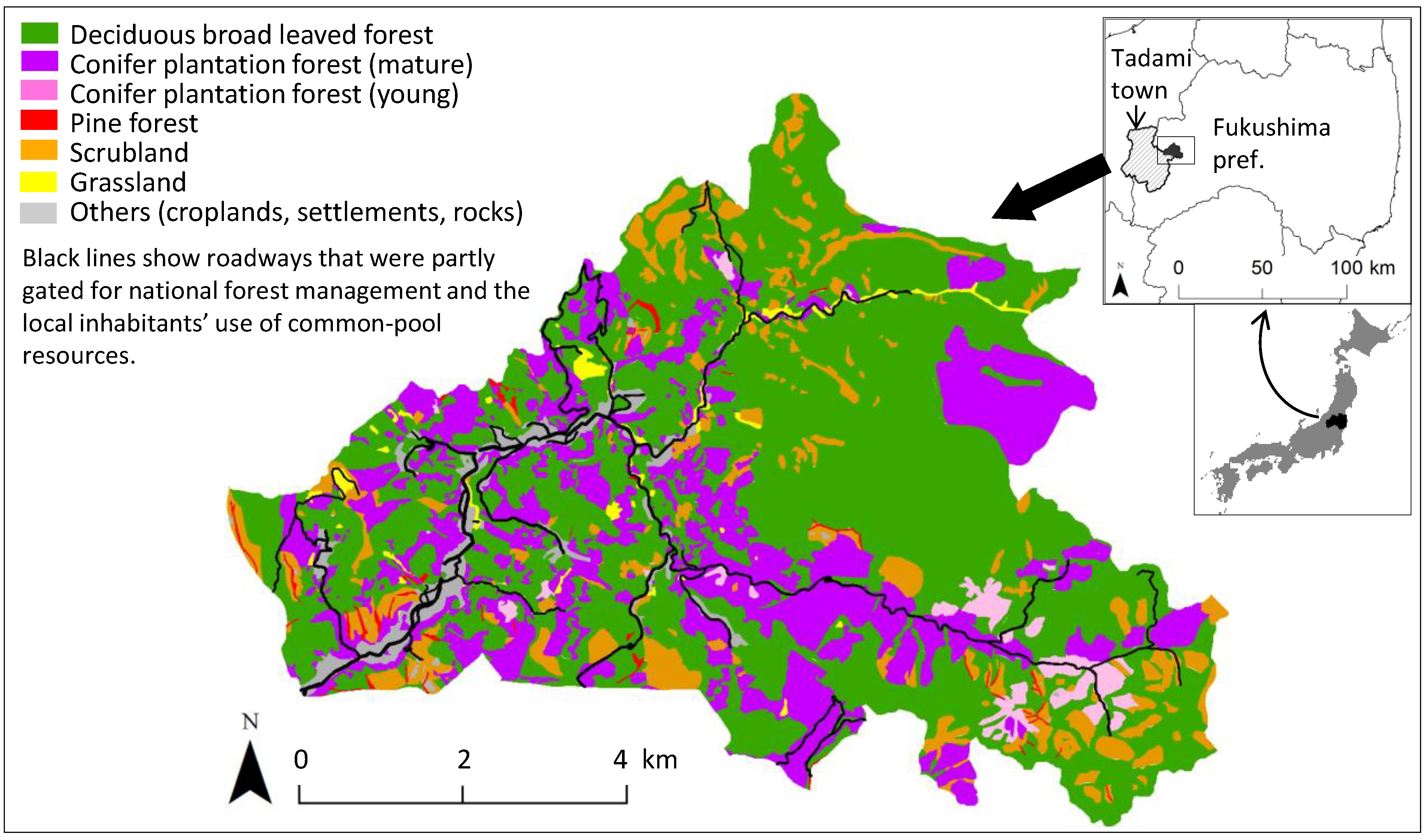
2.1. Study Area

2.2. Target Fern Species
2.3. GIS Data Set

| Explanatory Variables | Description | Min | Max | Mean | Std. Dev. | Unit |
|---|---|---|---|---|---|---|
| Vegetation | Vegetation classes: deciduous broadleaved forest, young and mature conifer plantations, pine forest, scrubland, and grassland. | (binary) | - | |||
| Terrain features derived from a 20-m DEM a | ||||||
| Gradient | Gradient measured as the maximum rate of change in surface elevation between each cell and its neighbors. | 0.06 | 54.68 | 21.41 | 8.63 | degrees |
| Aspect | Aspect measured clockwise from north. | 0 | 360 | 184.7 | 103.7 | degrees |
| Relative slope position | Relative slope position was measured by the height from the nearest drainage line to each grid point [46] divided by the vertical size of a side slope profile, i.e., height between the nearest drainage and ridge lines. | 0 | 1 | 0.63 | 0.33 | - |
| Proximity to roads | Path distance to the nearest roadway on a 20-m DEM. Inverse distance weighting up to 60 degrees in both upslope and down slope directions was applied. | 0 | 2538.6 | 652.3 | 542.4 | m |
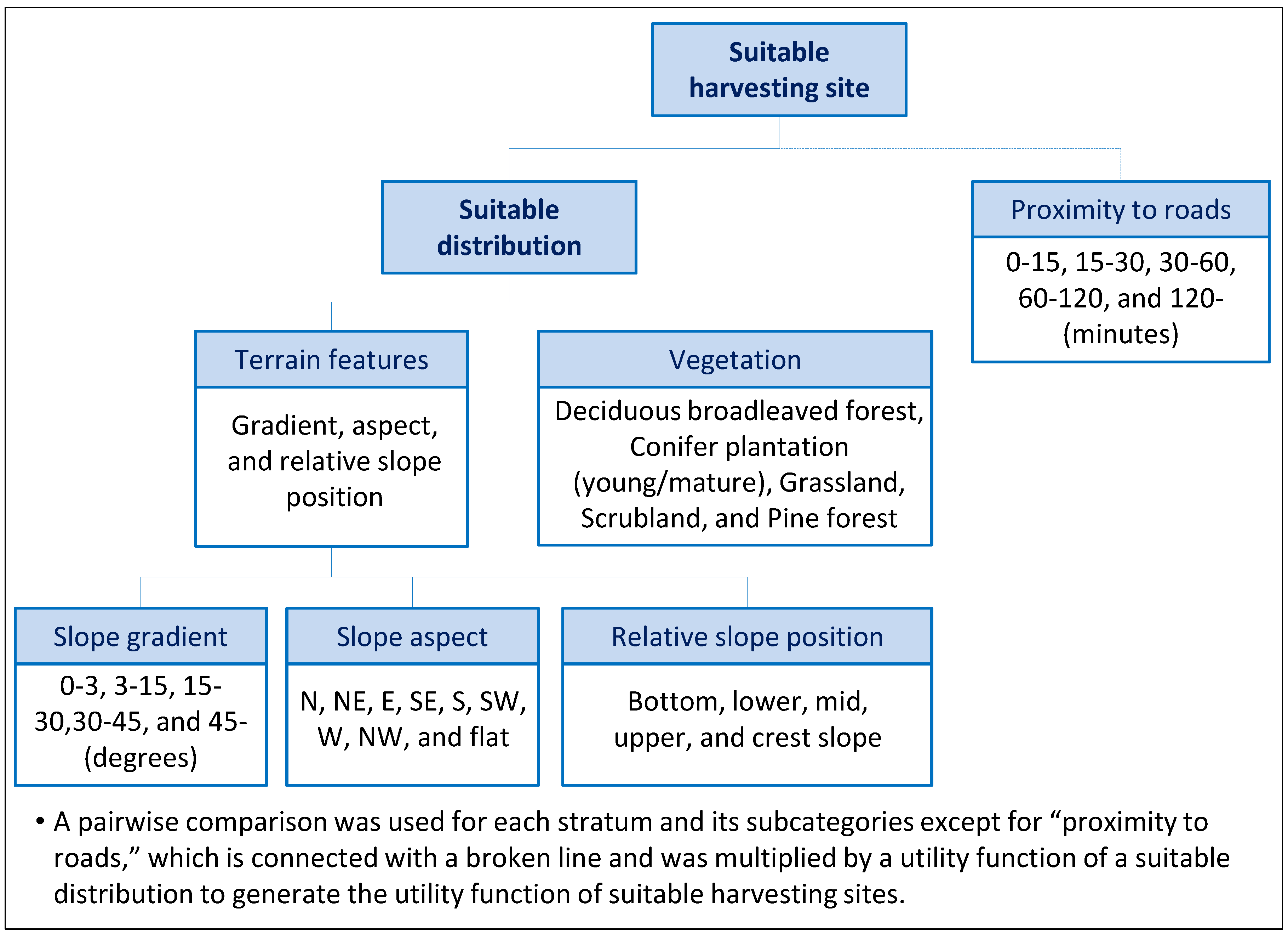
2.4. MCE

2.5. Model Verification
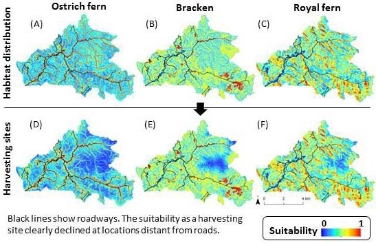
3. Results


4. Discussion
5. Conclusions
Acknowledgments
Conflicts of Interest
References
- Charnley, S.; Fischer, P.A.; Jones, T.E. Integrating tradtional and local ecological knowledge into forest biodiversity conservation in the Pacific Northwest. For. Ecol. Manag. 2007, 246, 14–28. [Google Scholar] [CrossRef]
- Berkes, F.; Colding, J.; Folke, C. Rediscovery of traditional ecological knowledge as adaptive management. Ecol. Appl. 2000, 10, 1251–1262. [Google Scholar] [CrossRef]
- Trosper, R.L.; Parrotta, J.A. Introduction: The Growing Importance of Traditional Forest-Related Knowledge. In Traditional Forest-Related Knowledge: Sustaining Communities, Ecosystems and Biocultural Diversity; Parrotta, J.A., Trosper, R.L., Eds.; Springer: Berlin, Germany, 2012; Volume 12, pp. 1–36. [Google Scholar]
- Pei, S.; Zhang, G.; Huai, H. Application of traditional knowledge in forest management: Ethnobotanical indicators of sustainable forest use. For. Ecol. Manag. 2009, 257, 2017–2021. [Google Scholar] [CrossRef]
- Delang, C.O. Not just minor forest products: The economic rationale for the consumption of wild food plants by subsistance farmers. Ecol. Econ. 2006, 59, 64–73. [Google Scholar] [CrossRef]
- Jones, T.E.; Lynch, A.K. Nontimber forest products and biodiversity management in the Pacific Northwest. For. Ecol. Manag. 2007, 246, 29–37. [Google Scholar] [CrossRef]
- Shackleton, C.M.; Pandey, A.K. Positioning non-timber forest products on the development agenda. For. Policy Econ. 2013, 38, 1–7. [Google Scholar] [CrossRef]
- Pandit, B.H.; Thapa, G.B. A tragedy of non-timber forest resources in the mountain commons of Nepal. Environ. Conserv. 2003, 30, 283–292. [Google Scholar] [CrossRef]
- Mutenje, M.J.; Ortmann, G.F.; Ferrer, S.R.D. Management of non-timber forestry products extraction: Local institutions, ecological knowledge and market structure in South-Eastern Zimbabwe. Ecol. Econ. 2011, 70, 454–461. [Google Scholar] [CrossRef]
- Ticktin, T. The ecological implication of harvesting non-timber forest products. J. Appl. Ecol. 2004, 41, 11–21. [Google Scholar]
- Ticktin, T.; Shackleton, C. Harvesting Non-Timber Forest Products Sustainably: Opportunities and Challenges. In Non-Timber Forest Products in the Global Context; Shackleton, S., Shackleton, C., Shanley, P., Eds.; Springer: Berlin, Germany, 2011; Volume 7, pp. 149–169. [Google Scholar]
- Stanley, D.; Voeks, R.; Short, L. Is non-timber forest product harvest sustainable in the less developed world? A systematic review of the recent economic and ecological literature. Ethnobiol. Conserv. 2012, 1, 1–39. [Google Scholar]
- Schreckenberg, K. Products of a managed landscape : Non-timber forest products in the parklands of the Bassila region, Benin. Glob. Ecol. Biogeogr. 2013, 8, 279–289. [Google Scholar]
- Drew, C.A.; Perera, A.H. Expart Knowledge as a Basis for Landscape Ecological Predictive Models. In Predictive Species and Habitat Modeling in Landscape Ecology: Concepts and Applications; Drew, C.A., Wiersma, Y.F., Huettmann, F., Eds.; Springer: Berlin, Germany, 2011; pp. 229–248. [Google Scholar]
- Yamada, K.; Elith, J.; Mccarthy, M.; Zerger, A. Eliciting and integrating expert knowledge for wildlife habitat modelling. Ecol. Model. 2003, 165, 251–264. [Google Scholar] [CrossRef]
- Rist, L.; Shaanker, R.U.; Milner-Gulland, E.J.; Ghazoul, J. The use of traditional ecological knowledge in forest management: An example from India. Ecol. Soc. 2010, 15. Article 3. [Google Scholar]
- Store, R.; Kangas, J. Integrating spatial multi-criteria evaluation and expart knowledge for GIS-based habitat suitability modelling. Landsc. Urban Plann. 2001, 55, 79–93. [Google Scholar] [CrossRef]
- Store, R.; Jokimäki, J. A GIS-based multi-scale approach to habitat suitability modeling. Ecol. Model. 2003, 169, 1–15. [Google Scholar] [CrossRef]
- Phua, M.-H.; Minowa, M. A GIS-based multi-criteria decision making approach to forest conservation planning at a landscape scale: A case study in the Kinabalu Area, Sabah, Malaysia. Landsc. Urban Plann. 2005, 71, 207–222. [Google Scholar] [CrossRef]
- Malczewski, J. GIS-based multicriteria decision analysis: A survey of the literature. Int. J. Geogr. Inf. Sci. 2006, 20, 703–726. [Google Scholar] [CrossRef]
- Mendoza, A.G.; Martins, H. Multi-criteria decision analysis in natural resource management: A critical review of methods and new modelling paradigms. For. Ecol. Manag. 2006, 230, 1–22. [Google Scholar] [CrossRef]
- Parrotta, J.A.; Fui, L.H.; Jinlong, L.; Ramakrishnan, P.S.; Yeo-Chang, Y. Traditional forest-related knowledge and sustainable forest management in Asia. For. Ecol. Manag. 2009, 257, 1987–1988. [Google Scholar] [CrossRef]
- Yang, X.; Skidmore, K.A.; Melick, R.D.; Zhou, Z.; Xu, J. Mapping non-wood forest product (matsutake mushrooms) using logistic regression and a GIS expart system. Ecol. Model. 2006, 198, 208–218. [Google Scholar] [CrossRef]
- Ikeya, K. Spatial structure of Zenmai gathering: A case study of the mountain village in the heavy snow zone. Sci. Rep. Tohoku Univ. 7th Ser. 1988, 38, 104–118. [Google Scholar]
- Ikeya, K. Cultural ecology of Zenmai gathering in the northeastern Japan. Sci. Rep. Tohoku Univ. 7th Ser. 2004, 53, 1–28. [Google Scholar]
- Inoue, T. The transaction of wild plant use as food: The case study of wild vegetables and mushrooms in Akiyamago-district, Sakae, Nagano. (in Japanese). Ecosophia 2002, 10, 77–100. [Google Scholar]
- Saito, H. Wild edible plant gathering activities practiced at ecotones: Two contrasting case studies of villages in Japan. (in Japanese with English abstract). Bull. Natl. Mus. Jpn. Hist. 2005, 123, 325–353. [Google Scholar]
- Kawarasaki, H.S.; Sugimura, K. Estimation of frequency and locality of collection of wild mushroom and wild vegetables by internet search. (in Japanese with English abstract). J. Jpn. For. Soc. 2012, 94, 95–99. [Google Scholar] [CrossRef]
- Matsuura, T.; Hayashi, M.; Sugimura, K.; Tanaka, N.; Miyamoto, A. Ecosystem services valuation of gathering edible wild plants/mushrooms—a case study in Tadami town, Fukushima prefecture. (in Japanese with English abstract). Jpn. J. For. Plann. 2013, 47, 55–80. [Google Scholar]
- Saito, H. Activities of gathering wild edible plants and mushrooms by city dwellers: Analysises of its background and characteristics through quesitionnaire surveys on mountaineering club members in Iwate and Kyoto prefectures. (in Japanese). For. Econ. 2005, 58, 1–16. [Google Scholar]
- Kashimura, T. Ecological study of the natural forest vegetation in the snowy region along the lower Tadami valley. Ecol. Rev. 1968, 17, 153–170. [Google Scholar]
- Kawano, S.; Nikkuni, I. Forest Vegetation, Flora and Fauna, and Biodiversity in Tadami-machi, Fukushima Prefecture, Honshu, Japan: Primaeval Beech and Riparian Forests, Sustainable Rich Flora and Fauna; Tadami-machi Board of Education: Fukushima, Japan, 2004. [Google Scholar]
- Sato, T. Phenology and wintering capacity of sporophytes and gametophytes of ferns native to northern Japan. Oecologia 1982, 55, 53–61. [Google Scholar] [CrossRef]
- Iwatsuki, K. Ferns and Fern Allies of Japan; (in Japanese with English abstract); Heibonsha Ltd.: Tokyo, Japan, 1992; p. 311. [Google Scholar]
- Odland, A.; Naujalis, J.R.; Stapulionytė, A. Variation in the structure of Matteuccia struthiopteris populations in Lithuania. Biologija 2006, 1, 83–90. [Google Scholar]
- Von Aderkas, P. Economic history of ostrich fern, Matteuccia struthiopteris, the edible fiddlehead. Econ. Bot. 1984, 38, 14–23. [Google Scholar] [CrossRef]
- Page, C.N. The taxonomy and phytogeography of bracken. Bot. J. Linn. Soc. 1976, 73, 1–34. [Google Scholar]
- Pakeman, R.J.; Marrs, R.H. The conservation value of bracken, Pteridium aquilinum (L.) Kuhn-dominated communities in the UK, and an assessment of the ecological impact of bracken expansion or its removal. Biol. Conserv. 1992, 62, 101–114. [Google Scholar] [CrossRef]
- Gil da Costa, R.M.; Bastos, M.; Oliveira, P.A.; Lopes, C. Bracken-associated human and animal health hazards: Chemical, biological and pathological evidence. J. Hazard. Mater. 2012, 203–204, 1–12. [Google Scholar] [CrossRef]
- Hodge, W.H. Fern foods of Japan and the probrem of toxicity. Am. Fern J. 1973, 63, 77–80. [Google Scholar] [CrossRef]
- May, L.W. The economic uses and associated folklore of ferns and fern allies. Bot. Rev. 1978, 44, 491–528. [Google Scholar] [CrossRef]
- Pemberton, R.; Lee, N. Wild food plants in South Korea; market presence, new crops, and exports to the United States. Econ. Bot. 1996, 50, 57–70. [Google Scholar] [CrossRef]
- Hirono, I. Edible plants containing naturally occurring carcinogens in Japan. Jpn. J. Cancer Res. 1993, 84, 997–1006. [Google Scholar] [CrossRef]
- Kato, M. Distribution of Osmundaceae. Bull. Natl. Museum Nat. Sci. Ser. B (Bot.) 2007, 33, 81–90. [Google Scholar]
- Kawabata, Y. Shokusei: Tadami-machi-no-shinrin-ya-sougen. In Aizu Tadami no Shizen: Shokubutsu-hen; (in Japanese). Tadami-machi, shishi-hensan-iinkai, Ed.; Tadami-machi town office: Fukushima, Japan, 2001; pp. 52–71. [Google Scholar]
- Rennó, D.G.; Nobre, D.A.; Cuartas, A.L.; Soares, V.J.; Hodnett, G.M.; Tomasella, J.; Waterloo, J.M. HAND, a new terrain descriptor using SRTM-DEM: Mapping terra-firme rainforest environment in Amazonia. Rem. Sens. Environ. 2008, 112, 3469–3481. [Google Scholar] [CrossRef]
- Kangas, S.A.; Horne, P.; Leskinen, P. Measuring the value of information in multicriteria decisionmaking. For. Sci. 2010, 56, 558–566. [Google Scholar]
- Saaty, T.L. The Analytic Hierarchy Process; McGraw-Hill: New York, NY, USA, 1980; p. 287. [Google Scholar]
- Yalcin, A. GIS-based landslide susceptibility mapping using analytical hierarchy process and bivariate statistics in Ardesen (Turkey): Comparisons of results and confirmations. Catena 2008, 72, 1–12. [Google Scholar]
- Estoque, R.C. Analytic Hierarchy Process in Geospatial Analysis. In Progress in Geospatial Analysis; Murayama, Y., Ed.; Springer: Berlin, Germany, 2012; pp. 157–181. [Google Scholar]
- Pukkala, T.; Kangas, J. A heuristic optimization method for forest planning and decision making. Scand. J. For. Res. 1993, 8, 560–570. [Google Scholar] [CrossRef]
- Beyer, H.L. Geospatial Modelling Environment. (Version: 0.7.2.1). Available online: http://www.spatialecology.com/gme (accessed on 11 October 2013).
- Hirzel, A.H.; Guisan, A. Which is the optimal sampling strategy for habitat suitability modelling. Ecol. Model. 2002, 157, 331–341. [Google Scholar] [CrossRef]
- Fielding, H.A.; Bell, F.J. A review of methods for the assessment of prediction errors in conservation presence/absence models. Environ. Conserv. 1997, 24, 38–49. [Google Scholar] [CrossRef]
- Manel, S.; Williams, C.H.; Ormerod, J.S. Evaluating presence-absence models in ecology: The need to account for prevalence. J. Appl. Ecol. 2001, 38, 921–931. [Google Scholar]
- Freeman, E.; Moisen, G. A comparison of the performance of threshold criteria for binary classification in terms of predicted prevalence and kappa. Ecol. Model. 2008, 217, 48–58. [Google Scholar] [CrossRef]
- Pearce, J.; Ferrier, S. Evaluating the predictive performance of habitat models developed using logistic regression. Ecol. Model. 2000, 133, 225–245. [Google Scholar] [CrossRef]
- Mizuno, N. Sansai/Kinomi. Yama-Kei Pocket Guide 4; (in Japanese). Yama-kei Publishers co., Ltd.: Tokyo, Japan, 1999; p. 281. [Google Scholar]
- Thayer, S. Nature’s Garden: A Guide to Identifying, Harvesting, and Preparing Edible Wild Plants; Forager’s Harvest Press: Birchwood, OH, USA, 2006; p. 360. [Google Scholar]
- Ohsawa, A. Fukushima-no-sansai-to-kinoko; (in Japanese). Rekishi-Shunju-Shuppan Co. Ltd.: Fukushima, Japan, 2001; p. 184. [Google Scholar]
- Suzuki, W.; Osumi, K.; Masaki, T.; Takahashi, K.; Daimaru, H.; Hoshizaki, K. Disturbance regimes and community structures of a riparian and an adjacent terrace stand in the Kanumazawa. For. Ecol. Manag. 2002, 157, 285–301. [Google Scholar] [CrossRef]
- Kawanishi, M.; Sakio, H.; Kubo, M.; Shimano, K.; Ohno, K. Effect of micro-landforms on forest vegetation differentiation and life-form diversity in the Chichibu Mountains, Kanto District, Japan. Veg. Sci. 2006, 23, 13–24. [Google Scholar]
- Shimada, Y. Ecology of bracken (Pteridium aquilinum (L.) Kuhn): Dynamics of bracken population in native grassland. (in Japanese with English abstract). Weed Res. 1962, 1, 70–77. [Google Scholar]
- Higuchi, K.; Sato, A.; Kato, R.; Shimoda, H. Studies on the weed-vegetation at the early stage of plantation (I): Vegetative transition on Cryptomeria japonica forests planted in every year. (in Japanese with English abstract). J. Jpn. For. Soc. 1975, 57, 346–350. [Google Scholar]
- Sugiura, T. Warabi (Pteridium aquilinum) and Sugi (Cryptomeria japonica) under intensive agroforestry. (in Japanese). J. Jpn. For. Soc. 1988, 70, 163–171. [Google Scholar]
- Aiura, H. Erosive phenomenon in heavy snow mountainous regions in Japan. J. For. Res. 2002, 7, 57–66. [Google Scholar] [CrossRef]
- Shimokawa, K. Geomorphic study of avalanche chute in the upper drainage basin of the Tadami River. (in Japanese with English abstract). Geogr. Rev. Jpn. 1980, 53, 171–188. [Google Scholar] [CrossRef]
- Nagamatsu, D.; Miura, O. Soil disturbance regime in relation to micro-scale landforms and its effects on vegetation structure in a hilly area in Japan. Plant Ecol. 1997, 133, 191–200. [Google Scholar]
- Sugimura, K.; Okitsu, S. Disturibution of bryophyte, pteridophyte, and flowering plant species in relation to the micro-landform in the Cryptomeria japonica and Chamaesyparis obtusa plantations of Mt. Tsukuba, central Japan. (in Japanese with English abstract). Veg. Sci. 2009, 26, 33–48. [Google Scholar]
- Hiruma, A.; Hukusima, T. Geographical differences in the habitat of forb species occuring in Japanese beech (Fagus crenata) forest zone. (in Japanese with English abstract). Veg. Sci. 2004, 21, 39–50. [Google Scholar]
- Osumi, K.; Ikeda, S.; Okamoto, T. Vegetation patterns and their dependency on site conditions in the pre-industrial landscape of north-eastern Japan. Ecol. Res. 2003, 18, 753–765. [Google Scholar] [CrossRef]
- Landi, M.; Angiolini, G. Ecological responses of Osmunda regalis to forest canopy cover and grazing. Am. Fern J. 2010, 100, 137–147. [Google Scholar] [CrossRef]
- Albers, H.; Robinson, E. A review of the spatial economics of non-timber forest product extraction: Implications for policy. Ecol. Econ. 2013, 92, 87–95. [Google Scholar] [CrossRef]
- Rist, L.; Shanley, P.; Sunderland, T.; Sheil, D.; Ndoye, O.; Liswanti, N.; Tieguhong, J. The impacts of selective logging on non-timber forest products of livelihood importance. For. Ecol. Manag. 2012, 268, 57–69. [Google Scholar] [CrossRef]
- Guariguata, M.; García-Fernández, C. Compatibility of timber and non-timber forest product management in natural tropical forests: Perspectives, challenges, and opportunities. For. Ecol. Manag. 2010, 259, 237–245. [Google Scholar] [CrossRef]
© 2013 by the authors; licensee MDPI, Basel, Switzerland. This article is an open access article distributed under the terms and conditions of the Creative Commons Attribution license (http://creativecommons.org/licenses/by/3.0/).
Share and Cite
Matsuura, T.; Sugimura, K.; Miyamoto, A.; Tanaka, N. Knowledge-Based Estimation of Edible Fern Harvesting Sites in Mountainous Communities of Northeastern Japan. Sustainability 2014, 6, 175-192. https://doi.org/10.3390/su6010175
Matsuura T, Sugimura K, Miyamoto A, Tanaka N. Knowledge-Based Estimation of Edible Fern Harvesting Sites in Mountainous Communities of Northeastern Japan. Sustainability. 2014; 6(1):175-192. https://doi.org/10.3390/su6010175
Chicago/Turabian StyleMatsuura, Toshiya, Ken Sugimura, Asako Miyamoto, and Nobuhiko Tanaka. 2014. "Knowledge-Based Estimation of Edible Fern Harvesting Sites in Mountainous Communities of Northeastern Japan" Sustainability 6, no. 1: 175-192. https://doi.org/10.3390/su6010175
APA StyleMatsuura, T., Sugimura, K., Miyamoto, A., & Tanaka, N. (2014). Knowledge-Based Estimation of Edible Fern Harvesting Sites in Mountainous Communities of Northeastern Japan. Sustainability, 6(1), 175-192. https://doi.org/10.3390/su6010175