

Study on Suburban Land Use Optimization from the Perspective of Flood Mitigation—A Case Study of Pujiang Country Park in Shanghai
Abstract
:1. Introduction
2. Materials and Methods
2.1. Study Area
2.2. Data
2.3. Methodology
2.3.1. Terrain Correction
2.3.2. Stormwater Scenarios and Land Use Scenarios Design
2.3.3. Stormwater Flood Simulation
- SCS Model
- 2.
- GIS-based flood simulation
3. Results
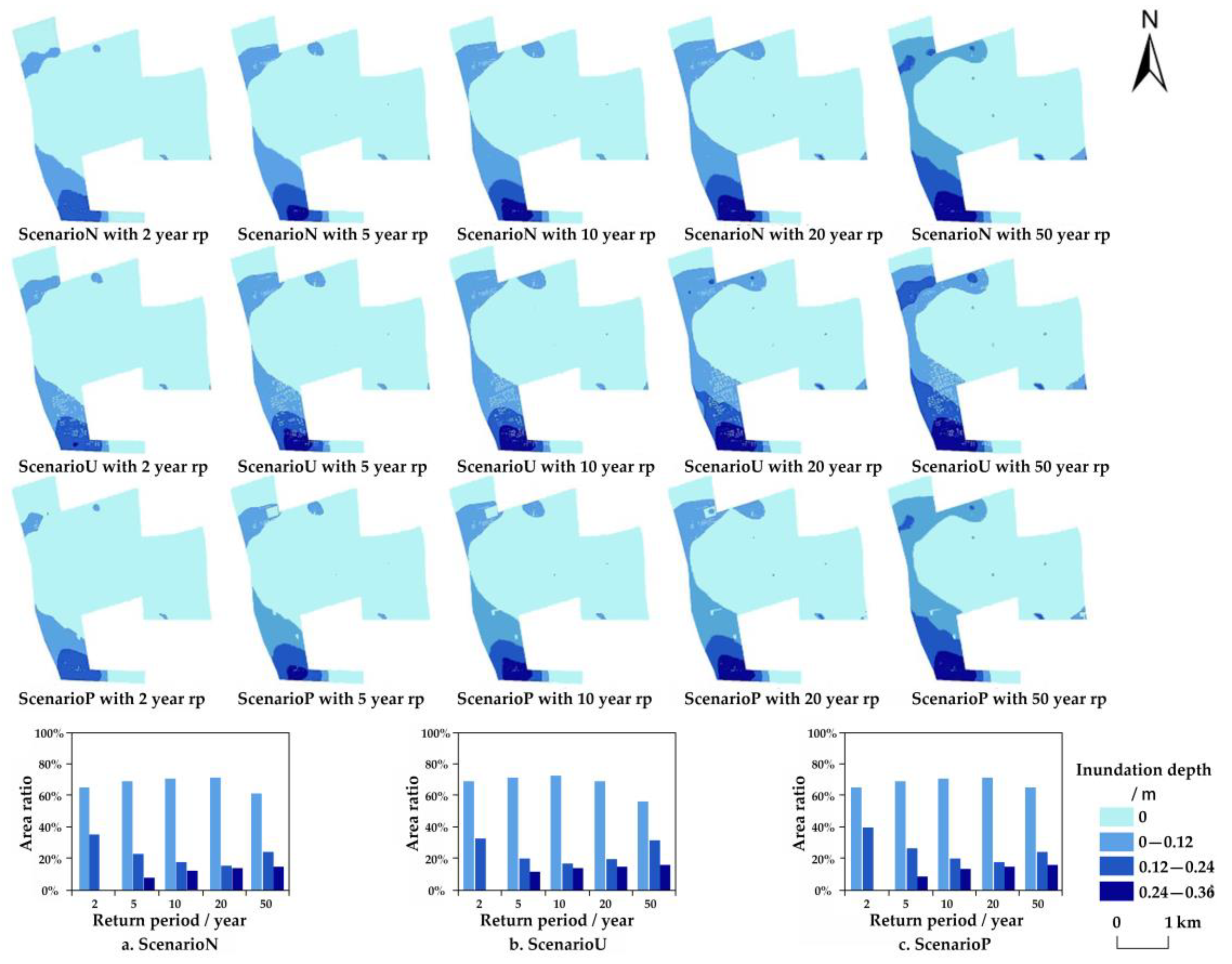
3.1. Flood Regulation Functions Assessment
3.2. Suggestions for Land Use Optimization from the Perspective of Flood Mitigation
3.2.1. Adjustment of Land Use Structure
3.2.2. Optimization of Land Use Layout
4. Conclusions and Discussion
4.1. Conclusions
4.2. Discussion
Author Contributions
Funding
Institutional Review Board Statement
Informed Consent Statement
Data Availability Statement
Conflicts of Interest
References
- Yin, Z.E.; Xu, S.Y.; Yin, J.; Wang, J. Small-Scale Based Scenario Modeling and Disaster Risk Assessment of Urban Rainstorm Water-Logging. Acta Geogr. Sin. 2010, 65, 553–562. [Google Scholar]
- Zhang, Z.; Liu, Q.; Liu, C.; Ding, L.; Ma, Q.; Chen, Y. Driving Effects and Spatial-Temporal Variations in Economic Losses Due to Flood Disasters in China. Water 2022, 14, 2266. [Google Scholar] [CrossRef]
- Ferreira, C.S.S.; Mourato, S.; Kasanin-Grubin, M.; Ferreira, A.J.; Destouni, G.; Kalantari, Z. Effectiveness of Nature-Based Solutions in Mitigating Flood Hazard in a Mediterranean Peri-Urban Catchment. Water 2020, 12, 2893. [Google Scholar] [CrossRef]
- Du, S.; Wang, C.; Shen, J.; Wen, J.; Gao, J.; Wu, J.; Lin, W.; Xu, H. Mapping the Capacity of Concave Green Land in Mitigating Urban Pluvial Floods and Its Beneficiaries. Sustain. Cities Soc. 2019, 44, 774–782. [Google Scholar]
- Debele, S.E.; Leo, L.S.; Kumar, P.; Sahani, J.; Ommer, J.; Bucchignain, E.; Vranic, S.; Kalas, M.; Amirzada, Z.; Pavlova, I.; et al. Nature-Based Solutions Can Help Reduce the Impact of Natural Hazards: A Global Analysis of NBS Case Studies. Sci. Total Environ. 2023, 902, 165824. [Google Scholar] [CrossRef]
- Senes, G.; Ferrario, P.S.; Cirone, G.; Fumagalli, N.; Frattini, P.; Sacchi, G.; Vale, G. Nature-Based Solutions for Storm Water Management—Creation of a Green Infrastructure Suitability Map as a Tool for Land-Use Planning at the Municipal Level in the Province of Monza-Brianza (Italy). Sustainability 2021, 13, 6124. [Google Scholar] [CrossRef]
- Mcdonough, K.R.; Hutchinson, S.L.; Liang, J.; Hefley, T.; Hutchinson, J. Spatial Configurations of Land Cover Influence Flood Regulation Ecosystem Services. J. Water Resour. Plan. Manag. 2020, 146, 04020082. [Google Scholar] [CrossRef]
- Banjara, M.; Bhusal, A.; Ghimire, A.B.; Kalra, A. Impact of Land Use and Land Cover Change on Hydrological Processes in Urban Watersheds: Analysis and Forecasting for Flood Risk Management. Geosciences 2024, 14, 40. [Google Scholar] [CrossRef]
- Peng, J.; Wei, H.; Wu, W.; Liu, Y.; Wang, Y. Storm Flood Disaster Risk Assessment in Urban Area Based on the Simulation of Land Use Scenarios: A case of Maozhou Watershed in Shenzhen City. Acta Ecol. Sin. 2018, 38, 3741–3755. [Google Scholar]
- Jiang, W.; Yu, J.; Xu, S. Impact of Urbanization in the Meixi River Basin on Flood Process in Piedmont Plain Area. Water Resour. Prot. 2023, 39, 74–100. [Google Scholar]
- Jiang, L.; Yu, J.; Wen, J.; Tang, J.; Qi, M.; Wang, L.; Zhang, M. Risk Assessment of Extreme Flood in the North Bank of the Hangzhou Bay Under Land Use Change Scenarios. Prog. Geogr. 2021, 40, 1355–1370. [Google Scholar] [CrossRef]
- Wang, Q.; Tian, J.; Zeng, J.; Wang, N. Construction of Flood Adaptation Network and Planning Response of Strategy Urban Agglomeration in the Min Delta Based on Scenario Simulation. J. Hydraul. Eng. 2022, 53, 876–889. [Google Scholar]
- Mabrouk, M.; Han, H.; Fan, C.; Abdrabo, K.I.; Shen, G.; Saber, M.; Kantoush, S.A.; Sumi, T. Assessing the Effectiveness of Nature-Based Solutions-Strengthened Urban Planning Mechanisms in Forming Flood-Resilient Cities. J. Environ. Manag. 2023, 344, 118260. [Google Scholar] [CrossRef] [PubMed]
- Lin, J.; Zhao, Y. Territorial Spatial Governanceand Central-local Coordination: Basedon the Perspective of “Region-element” Coordination. J. Renmin Univ. China 2022, 36, 36–48. [Google Scholar]
- Asibey, M.O.; Asamoah, C.O.; Yeboah, V.; Poku-Boansi, M.; Adutwum, I.O.; Takyi, S.A.; Amponsah, O. Building Resilience to Flood Risks via Green Space Planning in Urban Ghana. SN Soc. Sci. 2023, 3, 188. [Google Scholar] [CrossRef]
- Vojinovic, Z.; Alves, A.; Patino, J.; Weesakul, S.; Keerakamolchai, W.; Meesuk, V.; Sanchez, A. Effectiveness of Small- and Large-Scale Nature-Based Solutions for Flood Mitigation: The Case of Ayutthaya, Thailand. Sci. Total Environ. 2021, 789, 14725. [Google Scholar] [CrossRef] [PubMed]
- Afriyanie, D.; Julian, M.M.; Riqqi, A.; Akbar, R.; Suroso, D.S.A.; Kustiwan, I. Re-Framing Urban Green Spaces Planning for Flood Protection through Socio-Ecological Resilience in Bandung City, Indonesia. Cities 2020, 101, 102710. [Google Scholar] [CrossRef]
- Chen, Y.; Ge, Y.; Chen, R.; Chen, W.; Ye, Z.; Liu, H. New Development of Urban Resilience Research in Foreign Countries under the Background of Climate Change. J. Catastrophology 2020, 35, 136–141. [Google Scholar]
- Minhang District Shanghai Urban Planning and Natural Resources Bureau. Revision of Pujiang Country Unit (Country Park) Planning, Minhang District, Shanghai (2015–2020). Available online: https://mp.weixin.qq.com/s/WZ_NQiS3c_doze7LoosIdQ (accessed on 23 November 2017).
- Hou, C. Shanghai Soil; Shanghai Science and Technology Press: Shanghai, China, 1992. [Google Scholar]
- Wang, L.; Zhang, M.; Wen, J.; Chong, Z.; Ye, Q.; Ke, Q. Simulation of Extreme Compound Coastal Flooding in Shanghai. Adv. Water Sci. 2019, 30, 546–555. [Google Scholar]
- Jing, Y.; Yin, Z.; Yin, J.; Wang, F.; Wen, J. GIS-Based Analysis on Rainstorm Waterlogging Hazards in Pudong New Area in Shanghai. J. Catastrophology 2010, 25, 58–63. [Google Scholar]
- Technical Regulations on Urban Planning Management of Shanghai Municipality. Available online: https://www.shanghai.gov.cn/nw12939/20200815/0001-12939_972.html (accessed on 18 October 2003).
- Zhou, Q.; Su, J.; Arnbjerg-Nielsen, K.; Ren, Y.; Luo, J.; Ye, Z.; Feng, J. A GIS-Based Hydrological Modeling Approach for Rapid Urban Flood Hazard Assessment. Water 2021, 13, 1483. [Google Scholar] [CrossRef]
- Shrestha, S.; Cui, S.; Xu, L.; Wang, L.; Manandhar, B.; Ding, S.P. Impact of Land Use Change Due to Urbanisation on Surface Runoff Using GIS-Based SCS–CN Method: A Case Study of Xiamen City, China. Land 2021, 10, 839. [Google Scholar] [CrossRef]
- Ding, S.; Wang, N.; Ni, L.L.; Zeng, J. Study on the Inundation Risk of Disaster Space in the Min Delta Urban Agglomeration Based on SCS-CN and GIS Coupling Model. J. Catastrophology 2021, 37, 171–177. [Google Scholar]
- Wu, A.; Huang, Y.; Zhang, S.X. Risk Assessment of Urban Waterlogging Disaster Based on SCS Model. J. Inst. Disaster Prev. 2020, 22, 50–57. [Google Scholar]
- Mewded, M.; Abebe, A.; Tilahun, S.; Agide, Z. Impact of Land Use and Land Cover Change on the Magnitude of Surface Runoff in the Endorheic Hayk Lake basin, Ethiopia. SN Appl. Sci. 2021, 3, 742. [Google Scholar] [CrossRef]
- Shen, J.; Du, S.; Huang, Q.; Yin, J.; Zhang, M.; Wen, J.; Gao, J. Mapping the City-Scale Supply and Demand of Ecosystem Flood Regulation Services—A Case Study in Shanghai. Ecol. Indic. 2019, 106, 105544. [Google Scholar] [CrossRef]
- Fei, X. Community-Based Waterlogging Disaster Risk Analysis and Management. Master Thesis, Shanghai Normal University, Shanghai, China, 2019. [Google Scholar]
- Zhang, H.; Yin, Z.; Yin, J. Vulnerability Assessment of Urban Rainstorm Water-Logging in Pudong of Shanghai in Terms of Land Use. J. Shanghai Norm. Univ. (Nat. Sci.) 2011, 40, 427–434. [Google Scholar]
- Urban Rainwater Drainage Planning of Shanghai (2020–2035). Available online: http://hd.ghzyj.sh.gov.cn/hdpt/gzcy/sj/202004/t20200429_967900.html (accessed on 29 April 2020).
- Li, J.; Zhu, Y. Conservation and Application of Native Plants in Country Parks—A Case Study of Pujiang Country Park Phase I Reconstruction in Shanghai. Landsc. Archit. 2020, 10, 25–30. [Google Scholar]
- Abass, K.; Buor, D.; Afriyie, K.; Dumedah, G.; Segbefi, A.Y.; Guodaar, L.; Garsonu, E.K.; Adu-Gyamfi, S.; Forkuor, D.; Ofosu, A.; et al. Urban Sprawl and Green Space Depletion: Implications for Flood Incidence in Kumasi, Ghana. Glob. Environ. Chang. 2021, 68, 102248. [Google Scholar] [CrossRef]
- Zhang, Z.; Paschalis, A.; Mijic, A. Planning London’s green spaces in an integrated water management approach to enhance future resilience in urban stormwater control. J. Hydrol. 2021, 597, 126126. [Google Scholar] [CrossRef]
- Ferreira, C.S.S.; Potocki, K.; Kapovic-Solomun, M.; Kalantari, Z. Nature-Based Solutions for Flood Mitigation and Resilience in Urban Areas. In Nature-Based Solutions for Flood Mitigation: Environmental and Socio-Economic Aspects; Springer International Publishing: Cham, Switzerland, 2021; pp. 59–78. [Google Scholar]
- Rojas, O.; Soto, E.; Rojas, C.; Lopez, J.J. Assessment of the Flood Mitigation Ecosystem Service in a Coastal Wetland and Potential Impact of Future Urban Development in Chile. Habitat Int. 2022, 123, 102554. [Google Scholar] [CrossRef]
- Lallemant, D.; Hamel, P.; Balbi, M.; Lim, T.N.; Schmitt, R.; Win, S. Nature-Based Solutions for Flood Risk Reduction: A Probabilistic Modeling Framework. One Earth 2021, 4, 1310–1321. [Google Scholar] [CrossRef]
- Kapetas, L.; Fenner, R. Integrating Blue-Green and Grey Infrastructure Through an Adaptation Pathways Approach to Surface Water Flooding. Philos. Trans. R. Soc. A 2020, 378, 20190204. [Google Scholar] [CrossRef] [PubMed]
- Chen, W.; Wang, W.; Huang, G.; Wang, Z.; Lai, C.; Yang, Z. The Capacity of Grey Infrastructure in Urban Flood Management: A Comprehensive Analysis of Grey Infrastructure and the Green-Grey Approach. Int. J. Disaster Risk Reduct. 2021, 54, 102045. [Google Scholar] [CrossRef]
- Wang, M.; Liu, M.; Zhang, D.; Zhang, Y.; Su, J.; Zhou, S.; Bakhshipour, A.E.; Tan, S.K. Assessing Hydrological Performance for Optimized Integrated Grey-Green Infrastructure in Response to Climate Change Based on Shared Socio-Economic Pathways. Sustain. Cities Soc. 2023, 91, 104436. [Google Scholar] [CrossRef]
- Wang, J.; Zhou, X.; Wang, S.; Chen, L.; Shen, Z. Simulation and Comprehensive Evaluation of the Multidimensional Environmental Benefits of Sponge Cities. Water 2023, 15, 2590. [Google Scholar] [CrossRef]


| Return Period (Year) | 2 | 5 | 10 | 20 | 50 |
|---|---|---|---|---|---|
| 1-h precipitation (mm) | 44.3 | 56.3 | 65.8 | 75.8 | 89.7 |
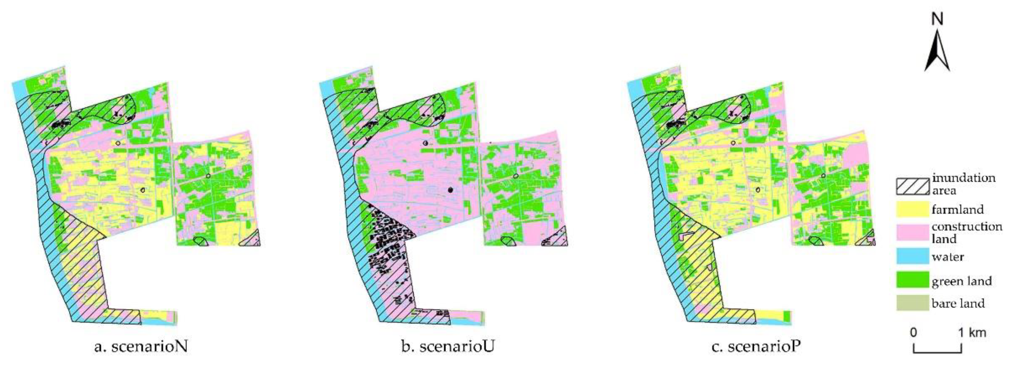
| Land Use Scenario | Scenario Explanation |
|---|---|
| Natural scenario (scenario N) | It refers to the natural state, where land use is not affected by excessive human interference and related planning. In this paper, we utilize the 2013 land use data, predating the construction of country parks, to represent the land use status in this scenario. |
| Complete urbanization scenario (scenario U) | It represents the condition of maximum urbanization of Pujiang Country Park. Constructed based on 2013 land use data, this scenario designates farmland as urban residential land, taking into consideration the current status of surrounding land use. |
| Country park planning scenario (scenario P) | It pertains to the land use state guided by scientific planning. In this paper, we adopt the land use settings outlined in the planning of Shanghai Pujiang Country Park as the representation of the land use status in this scenario. |
| Land Use/Cover | Soil Permeability | |||
|---|---|---|---|---|
| A | B | C | D | |
| Construction land | 77 | 85 | 90 | 92 |
| Bare land | 72 | 82 | 88 | 90 |
| Farmland | 67 | 76 | 83 | 86 |
| Green land | 34 | 60 | 74 | 80 |
| Water | 98 | 98 | 98 | 98 |
| Rp | 2-Year | 5-Year | 10-Year | 20-Year | 50-Year | ||||||
|---|---|---|---|---|---|---|---|---|---|---|---|
| Land Use | Inundation Area (km2) | Ratio (%) | Inundation Area (km2) | Ratio (%) | Inundation Area (km2) | Ratio (%) | Inundation Area (km2) | Ratio (%) | Inundation Area (km2) | Ratio (%) | |
| Scenario P | 1.89 | 12.41 | 2.66 | 17.52 | 3.21 | 21.11 | 3.76 | 24.75 | 4.52 | 29.69 | |
| Scenario N | 2.05 | 13.48 | 2.83 | 18.61 | 3.37 | 22.15 | 3.92 | 25.75 | 4.62 | 30.37 | |
| Scenario U | 2.31 | 15.21 | 3.06 | 20.10 | 3.61 | 23.71 | 4.17 | 27.44 | 4.86 | 31.93 | |
Disclaimer/Publisher’s Note: The statements, opinions and data contained in all publications are solely those of the individual author(s) and contributor(s) and not of MDPI and/or the editor(s). MDPI and/or the editor(s) disclaim responsibility for any injury to people or property resulting from any ideas, methods, instructions or products referred to in the content. |
© 2024 by the authors. Licensee MDPI, Basel, Switzerland. This article is an open access article distributed under the terms and conditions of the Creative Commons Attribution (CC BY) license (https://creativecommons.org/licenses/by/4.0/).
Share and Cite
Xu, H.; Gao, J.; Yu, X.; Wang, C.; Liu, Y.; Wen, J.; Qin, Q. Study on Suburban Land Use Optimization from the Perspective of Flood Mitigation—A Case Study of Pujiang Country Park in Shanghai. Sustainability 2024, 16, 3436. https://doi.org/10.3390/su16083436
Xu H, Gao J, Yu X, Wang C, Liu Y, Wen J, Qin Q. Study on Suburban Land Use Optimization from the Perspective of Flood Mitigation—A Case Study of Pujiang Country Park in Shanghai. Sustainability. 2024; 16(8):3436. https://doi.org/10.3390/su16083436
Chicago/Turabian StyleXu, Hui, Junlong Gao, Xinchun Yu, Chunyang Wang, Yi Liu, Jiahong Wen, and Qianqian Qin. 2024. "Study on Suburban Land Use Optimization from the Perspective of Flood Mitigation—A Case Study of Pujiang Country Park in Shanghai" Sustainability 16, no. 8: 3436. https://doi.org/10.3390/su16083436