Article

Resilience of Public Open Spaces to Earthquakes: A Case Study of Chongqing, China

1
School of Architecture and Urban Planning, Chongqing University, Chongqing 400044, China
2
Chongqing Architectural Design Institute Co., Ltd., Chongqing 400044, China
*
Author to whom correspondence should be addressed.
Sustainability 2023, 15(2), 1092; https://doi.org/10.3390/su15021092
Submission received: 18 November 2022 / Revised: 16 December 2022 / Accepted: 4 January 2023 / Published: 6 January 2023
(This article belongs to the Special Issue Disaster Risk Reduction and Resilient Built Environment)

Abstract

:
Public open spaces (POSs) can be crucial during earthquakes, serving as essential places for recovery and mitigation. However, the ability of POSs to respond to earthquakes varies based on their degree of resilience. Resilience plays a significant role in ensuring effective responsiveness to earthquakes in POSs, in addition to enhancing their daily use in normal times. By exploring and examining the earthquake resilience criteria that can be incorporated into the planning and design of POSs, this study aims to determine and enhance the ability of POSs to provide an effective response during earthquakes. Four main criteria consisting of twelve sub-criteria of earthquake resilience are investigated. The resilience criteria are applied and compared in 169 POSs in three different areas in Chongqing municipality in China. A geographic information system (GIS) is used to study the earthquake-resilience criteria of the POSs. The analytic hierarchy process (AHP) is used to weight the resilience criteria. Weighted overlay analysis (OWA) is used to determine the degrees of earthquake resilience of POSs. The results show the different potentials for earthquake resilience in POSs according to the area characteristics and POS type. The results also show that the current resilience degree of POSs is insufficient to respond effectively to earthquakes, especially severe ones. This study provides a valuable source for enhancing cities’ resilience against earthquake disasters.

1. Introduction

Over the last few decades, several extensive disasters occurred worldwide, resulting in significant economic losses and causing harm to millions of people [1]. Earthquakes are considered one of the most devastating natural disasters [2,3]. This is due to the increased urbanization and high population growth in earthquake-prone areas, with about 3 billion people living in seismically active areas, causing around 750,000 deaths in the last two decades from earthquakes and tsunamis [4]. By 2050, the population of major earthquake-prone cities is expected to double [5].
Public open spaces (POSs), such as squares, parks, and sports fields, are crucial for earthquake preparedness [6]. They are the safest locations to be during and after an earthquake due to building collapse, falling debris, fire, and gas leaks [7]. Emergency and recovery needs, such as evacuation, medical aid, social gatherings, communication, and water and food distribution, are commonly handled in a city’s POSs [8].
Studies on earthquake responses in many countries show the importance of POSs during earthquakes. However, most POSs are unprepared to respond effectively to earthquakes. In the 1906 San Francisco earthquake, most affected people moved to POSs. The parks played an essential role as an information source, support for the community, and shelter for affected people [9]. Ad hoc camps were set up in POSs of the city as shelters for affected people. However, the lack of basic services in the POSs caused a great challenge for the refugees, especially in the first days of sheltering [10]. In Mexico, POSs played a vital role following the 1985 earthquake. However, the responsiveness of the POSs was influenced by the grid regularity and POSs’ distribution [11]. The areas with a regular grid offered a better heterogeneous distribution of open space systems and ensured diversity and governance overlaps, which provided a better response [11]. In contrast, the areas with fragmented land and insufficient open spaces neither contributed to system diversity in terms of concentration of use nor to improved performance in governance [11]. In China, the responsiveness to the 2008 Wenchuan earthquake showed that the POSs were recovery centers for the affected people. However, owing to the absence of an effective disaster emergency plan, evacuations and access to recovery centers caused great losses [12]. In Chile, temporary camps were built for the people affected by the 2010 earthquake in open spaces (sports fields and local parks) in various regions. Yet, evacuees preferred to stay in the POSs near the road to resume trade, which led to congestion in these POSs, whereas POSs far from roads were undesirable [13].
Given the insufficient and ineffective response of POSs to past earthquakes, resilience becomes a necessity to enhance POSs’ responses to earthquakes. Resilience has a wide range of meanings in academic settings, depending on the aspect or field [14,15]. Resilience is commonly explained in disaster prevention as the ability to absorb and bounce back after a disaster [16]. Recently, the concept of “disaster resilience” has become increasingly essential in urban areas [17]. The notion of a “disaster-resilient city” has also been developed and is now commonly used in numerous disaster management studies and institutional policy texts [18].
In this regard, urban planning can significantly contribute to creating resilient disaster cities and be a key tool for reducing the devastating effects of disasters and strengthening community resilience through its ability to incorporate multi-dimensional aspects that reduce disasters’ effects. This significance is confirmed in much of the current literature [2,13,19,20]. Moreover, the importance of incorporating resilience enhancement and disaster risk reduction into urban planning processes has been highlighted in recent international agreements, such as the Hyogo Framework for Action (2005) [21], the 2030 Agenda for Sustainable Development (2015) [22], and the Sendai Framework for Disaster Risk Reduction (2015) [23].
Integrating earthquake disaster resilience into POS planning can especially offer chances to assist in an effective recovery and reduce losses if an earthquake happens [24]. However, research into how urban POS planning contributes to disaster resilience is scant, especially in the context of earthquake hazards [25]. The lack of strategy in recovery planning may be because planners usually plan for particular problems, and earthquakes or other shocks are regarded as too variable to plan and design for.
The great importance of POSs during earthquakes and the research gap in incorporating earthquake resilience in the planning of POSs highlight the urgent need for the present study. This study aims to create POSs that can respond effectively to earthquakes by answering the following questions:
Q1: What are the resilience criteria that can be incorporated into the planning of POSs to respond effectively to earthquakes?
Q2: How can the earthquake resilience criteria of POSs be examined and evaluated to determine their ability to provide effective responses during earthquakes?
This study analyzes four main criteria of earthquake resilience, which are accessibility, efficiency, safety, and multifunctionality. These criteria are applied to 169 POSs, including public parks, residential block parks, squares, sports fields, and waterfronts, in three different areas of Chongqing municipality (43 POSs in the Yuzhong district area, 61 POSs in the old Shapingba area, and 65 POSs in the university town area).
The novelty of this work is that it incorporates seismic resilience into the planning of POSs, creating POSs that perform effective functions during daily use and earthquakes. The findings of this work represent a significant source for planners and decision-makers to establish earthquake-resilient POSs, thereby contributing to reducing the cost of damage and loss of lives and increasing community resilience and sustainability.
The rest of the paper’s content is ordered as follows. The second section presents the materials and methods of the study. The first part of this section explains the earthquake-resilience criteria that can be integrated into the planning of POSs. The second part describes the studied area—Chongqing municipality—and the three research sites—the Yuzhong district area, old Shapingba area, and university town area. The third part details the study methods. The third section presents and evaluates the study’s results. The fourth section presents the conclusion of the study. The fifth section presents the study limitations and future research recommendations.

2. Materials and Methods

2.1. Earthquake Resilience Criteria

2.1.1. Accessibility

Accessibility is a flexible, slippery, and broad term [26]. It shows how quickly or far one has to travel to reach a place. It is frequently defined as a measure of how close two places are to one another [27,28,29]. Accessibility to POSs during earthquakes plays an important role in determining earthquake losses. Disturbances in the transportation and evacuation system may cause secondary risks that add more losses to the direct losses caused by seismic events [30,31].
Several studies have demonstrated the importance of the time to reach evacuation centers during earthquakes [32,33,34]. Macintyre et al. [35] found that, in severe earthquakes, the survival rates decrease for those facing difficulty in rapid evacuation. Moreover, in mountainous areas, such as Chongqing, transportation infrastructure is often poorer than that in other regions. Therefore, accessibility is critical when planning and designing POSs for earthquake-effective responses. Sites for POSs should be located as close to residents as possible, in a secure place without route obstruction, and within easy reach of health centers, security stations, and fire stations [36,37].
Most studies examined accessibility based on the distance function using methods such as the straight-line distance (Euclidian distance); the distance between the right-angled sides of a triangle, with the Euclidian distance as its foundation (Manhattan distance); and shortest network paths [38]. Others used the time-based function as the major limitation [39,40,41].
In this study, accessibility indicates the physical ease of reaching the POS. Accessibility is analyzed using the Euclidean distance to examine three sub-criteria: the distance from main roads, the walking time from buildings, and the distance from service centers (health centers, security stations, and fire stations) (Table 1). In addition, the quality and nature of roads and walking paths are examined.

2.1.2. Efficiency

The effectiveness of POSs indicates their ability to shelter the affected people during disasters [44]. The capacity of POSs is essential to make cities more earthquake-resilient [45].
Some studies have shown that large POSs are more valuable for earthquake responses, whereas smaller POSs are seen as having little to no impact [46,47]. In contrast, Chou et al. [48] showed that small POSs are utilized frequently following an earthquake. They found that incorporating small and medium-sized POSs into disaster planning does not necessitate substantial urban tissue alterations, allowing the preservation of the present urban and neighborhood structure. In addition, small POSs may be essential after a crisis in cities with a paucity of POSs.
Some studies classified POS shelters into four groups based on the duration of stay: emergency and temporary shelters, and temporary and permanent housing [48,49,50]. Emergency shelters are generally used for one to two days during a disaster [48,49,50]. Meanwhile, temporary shelters are used for a few weeks after a disaster; they can be a public mass shelter or tents set up in the POS [48,49,50]. Temporary housing refers to prefabricated houses or small shacks established in the POS to temporarily house the affected families until a permanent solution is obtained. It enables refugees to return to everyday activities and resume work and school [48,49,50]. Meanwhile, permanent housing refers to the construction of new houses in the POS to serve as permanent homes for families whose homes were destroyed during the disaster [48,49,50].
In other studies, POSs for sheltering were categorized as emergency, temporary, or permanent/long-term based on the surface area of the POS [51,52,53].
Masuda [8] showed that small POSs with a surface area of 1000 m2 to 2000 m2 are suitable for emergency refuges immediately after an earthquake, POSs with a surface area of over 2000 m2 to 30,000 m2 are appropriate for temporary shelter for around a week, and large-scale POSs are mostly used for long-term sheltering. On the other hand, according to China’s national standards for emergency shelter construction, small POSs with an area smaller than 2000 m2 are suitable for emergency refuges, POSs with an area of 2000–50,000 m2 are suitable for temporary shelter, and POSs with an area of more than 50,000 m2 are suitable for long-term shelter [42].
Regarding per-capita shelter in POSs, Tong et al. [54] showed that refugees needed more than 2–3 m2 of space for shelter. Masuda [8] noted that the open area size should be divided into 2 m2 per person. In addition, the SPHERE project stated that each person should have 3.5 m2, including the dining and restroom facilities; this figure rises to 4.5–5.5 m2 in cold-weather areas [55]. According to the urban planning and construction codes in China, however, the average per-capita shelter space in a shelter is 0.5 m2 for an emergency, 1 m2 for temporary shelters, and 4.5 m2 for long-term refuges [43].
Efficiency in this study is examined by measuring POSs’ usable size and determining their capacity to shelter affected people during earthquakes (Table 1). This study argues that small and large POSs can be used during earthquakes, especially in densely populated areas, such as Chongqing. However, large POSs are more effective than smaller spaces. The POSs’ capacities are compared with the population size of the area to determine the extent of the POSs’ present abilities to meet the sheltering requirements in the event of an earthquake, whether for emergency, temporary, or long-term shelter.

2.1.3. Safety

Ensuring safety is essential in planning and constructing POSs for shelter after an earthquake, considering that not all of these spaces are ideal for earthquake sheltering [33]. To use POSs following a seismic event, they must adhere to safety principles, prevent secondary hazards to their residents, and assure security inside the space [44]. POSs should be free of external physical risks and offer stable living conditions for occupants to regain their physical and mental well-being [56,57].
The literature emphasizes the need to use maps to identify locations that may be a source of secondary hazards, such as sites near flood sources [58], and the risk of building collapse, which is responsible for many casualties in cases of major earthquakes [59]. Additionally, further hazards that come from gas stations [60] and terrain slopes [61] must be considered when selecting POS locations to maintain refugees’ safety. Moreover, POSs should be secured through measures such as controlling access [62,63], fostering a sense of safety [64,65], and promoting surveillance [66,67].
This study measures safety by analyzing five sub-criteria: proximity to flood sources, proximity to fuel stations, building collapse hazards, slope, and monitoring and access control (Table 1).

2.1.4. Multifunctionality

Multifunctionality in POSs is an essential strategy for making spaces more responsive to earthquakes [13]. Multifunctionality in POSs fosters the adaptability culture and helps to build more resilient neighborhoods [68]. From the perspective of multifunctionality, POSs can serve several functions and meet multiple demands at once. POSs can simultaneously respond effectively to earthquakes and provide multiple sociocultural, ecological, economic, and aesthetic functions [69].
Therefore, multifunctionality should be incorporated into the planning and design of POSs to improve and expand disaster plans. POSs should be used for daily life needs while preserving the procedures required to support local communities and cope with unexpected calamities, such as earthquakes [8]. POSs’ responses to earthquakes are more effective if they are integrated into daily life [70]. POSs should be provided with resources, such as water and sanitation, which were effective features for using POSs in past earthquakes [19]. The level of dense vegetation in POSs should also be considered to ensure the ability of POSs to perform multiple functions, especially during earthquakes. Dense vegetation limits access or prohibits the creation of shelters in POSs. Turer Baskaya [71] found a negative correlation between a POS’s response to earthquakes and the presence of dense vegetation, such as low-canopy trees, bushes, and ground cover within the POS.
This study examines multifunctionality through three sub-criteria: services, presence of large and dense trees, and daily use (Table 1). The services are evaluated by investigating the availability of electricity, water, and sanitation; they are assessed on three levels: low, moderate, and high levels. As electricity is available in all studied POSs, according to the field investigation, POSs with a low level of services means that only electricity is present, the moderate level indicates the presence of two levels of services, and the high level indicates the presence of three levels. Large and dense trees are evaluated based on the presence of trees that may limit or hinder the construction of shelters. Daily use is evaluated by exploring the daily visits to the POSs and the quality and activities available in them.

2.2. Study Area and Research Sites

The study was conducted in Chongqing municipality, the largest city in southwest China. It is one of the four municipalities directly controlled by the Chinese central government, along with Beijing, Tianjin, and Shanghai. Chongqing is one of the most populated cities in China, with more than 30 million citizens and an area of around 82,400 km2 [72]. It is China’s most illustrious mountain city. It is located in the Yangtze River’s upper reaches, and it is crossed by four mountains that run north to south and two rivers that flow west to east.
In terms of geology, Chongqing is not situated in a very high-earthquake-risk area. It still should be ready all the time, given earthquakes’ unpredictable and sudden nature. In addition, rapid urbanization is accompanied by increased incidence and sudden burst disasters, particularly in mountain cities, such as Chongqing. Moreover, Chongqing is adjacent to Sichuan province, which is a high-earthquake-risk area, so Chongqing always is affected by earthquakes that hit Sichuan. A clear example is the massive 2008 Wenchuan earthquake that struck Sichuan and reached neighboring provinces, such as Chongqing, forcing many residents of Chongqing to leave their homes and live in POSs. The refugees faced several challenges, such as difficulties in accessing the POSs and the lack of basic needs in the POSs, such as water and sanitation. Therefore, studying how to respond to earthquakes in Chongqing is extremely important, because its high population density and complicated geographical setting make evacuation and refuge difficult.
To obtain a complete view of the city’s overall characteristics, this study was carried out in three different areas of Chongqing, each with its own unique traits.
The first area is located in the Yuzhong district, which is the central area and the heart of Chongqing municipality. It is the municipality’s capital and Chongqing’s most important economic and entertainment district. It is located on a peninsula shaped by the Yangtze–Jialing River intersection. Owing to its limited area, high population density, economic importance, and mountainous nature, Yuzhong contains some of the tallest skyscrapers in China. The studied area of Yuzhong is situated in the most important part of the district, linked to the area of the two rivers’ intersection (Figure 1a). According to the statistics from 2020, around 377,613 people live in the studied part, with an average density of approximately 50,348 people/km2 [73].
The second area of the study is located in the old part of the Shapingba district. Shapingba is one of the most significant of Chongqing’s urban-development areas. It is located in the southwest section of the municipality, adjacent to the Jialing River. The district is characterized by a variety of terraces, hills, and low mountains. The old Shapingba area selected in this study is situated on the Jialing River’s western bank (Figure 1b). It includes the locations of the district center, A, B, and C campuses of Chongqing University, and Ciqikou historic town. According to the statistics from 2020, around 213,134 people live in our studied part of old Shapingba, with an average density of approximately 27,324 people/km2 [74].
The third area of this study is located in the university town. A portion of the university town belongs to the district of Shapingba, whereas the other part is under the High Technology Authority (Direct Management Park). The selected part of this study is located in the Shapingba district section (Figure 1c). It is characterized by wide streets and newly established constructions, and it is one of the best open and flat areas in Chongqing. According to the 2020 statistics, around 186,449 people live in the studied part, with an average density of approximately 17,263 people/km2 [74].

2.3. Research Methods

2.3.1. Data Collection

The Chongqing master plan, Baidu maps, open street maps, satellite images, and field observation were used to determine the POSs and their earthquake-resilience criteria, including accessibility to POSs, the usable size of POSs, and safety and multifunctionality factors. All POSs in the studied areas were visited. During the visits, we were eager to use our senses to gather information about the study areas’ POSs, and the collected data were listed in written notes. A camera was used to record the different studied aspects to ensure that the observation data were accurate and thorough. The population statistics and the standards and codes related to planning for sheltering following earthquakes in China were collected by analyzing the official documents of the Chinese authorities [42,43,72,73,74].
Structured interviews were conducted with six experts in planning and designing safe cities in China, particularly in Chongqing. The interviews consisted of face-to-face and online interviews through the WeChat platform. The interviews mainly focused on determining the suitability criteria for earthquake-resilient POSs, which are presented in Table 1.
A questionnaire survey was carried out to evaluate the earthquake-resilience criteria of POSs. A total of 142 responses were collected from the specialists, including interviewees and other specialists in the fields of architecture, urban planning, landscape engineering, civil engineering, geology, and emergency and disaster management. The evaluation results were used to calculate the weights in the analytic hierarchy process described in the next part.

2.3.2. Data Processing and Analysis

A geographic information system (GIS) (ArcGIS 10.8.1) was used to study the resilience criteria of the POSs in the studied areas. A geographic information system is an automatic system for collecting, storing, retrieving, analyzing, and presenting data [75], where spatial data can be collected, integrated, and analyzed quickly and correctly using GIS-based spatial analysis, which is frequently utilized in the urban planning domain [76]. Based on the data collected from the sources presented in Section 2.3.1, the POSs locations, characteristics, and their usable sizes were determined. The Euclidean distance was used to examine the accessibility factors and the distance of POSs from hazard sources (flood sources, fuel stations, and existing buildings). The digital elevation model (DEM) was used to determine the slope factor. The field observation data were inserted into the GIS to analyze the monitoring and access control factor and multi-functionality sub-criteria. The analyzed data were presented in GIS maps.
In order to determine the earthquake resilience level in POSs, the study integrated the analytic hierarchy process with weighted overlay analysis.
(1) Analytical Hierarchy Process (AHP)
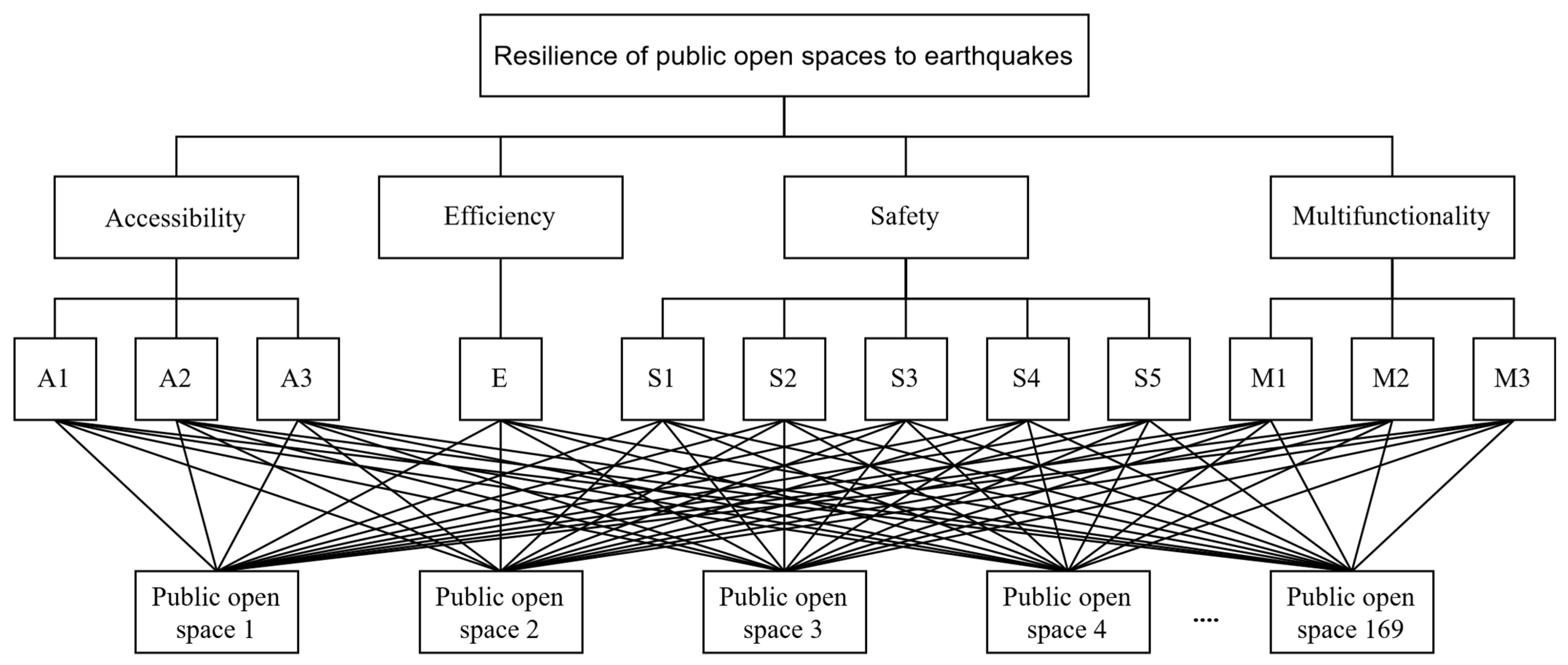
The AHP, developed in 1970 by Thomas L. Saaty, is one of the multiple criteria for decision-making [77]. It enables a decision-maker to deal with situations involving multiple contending and subjective factors [78]. Combining mathematics and psychology, the AHP method reduces complicated judgments to a simple hierarchy. It is an obvious systematic quantitative analytical method that is highly appropriate for multi-criteria calculation. An expert’s experience and literature review determine which criterion takes precedence over the others when making this decision [79]. According to de Brito and Evers [80], the AHP is the most common method used in studies that weigh factors. In this regard, many recent studies on disaster resilience used the AHP method to determine the weight of factors [61,81,82,83,84,85]. In this study, decision problems were structured in three hierarchical levels. The top level identifies the aim, and the second level contains relevant criteria for evaluating the options at the third level (Figure 2).
AHP was used to determine the criteria weights. This process was conducted through three steps: First, the importance scale was calculated. This step was conducted by analyzing the results of specialists’ evaluations of the earthquake resilience criteria and reclassifying them into the AHP numeric expressions on a scale from 1 to 9. The criteria for the weights are as follows: 9 = extremely appropriate, 7 = very appropriate, 5 = more appropriate, 3 = moderately appropriate, and 1 = not appropriate [79,86]. Second, based on the importance scale value, the pairwise comparison matrix was constructed to compare each pair of sub-criteria according to their importance (Table 2). Third, the matrix consistency was verified by calculating the consistency ratio (CR). CR = CI/RI. RI is the random index and CI = (λmax − n)/(n − 1), where λmax marks the principal eigenvalue and n indicates the order of the matrix. The result of CR = 0.01 < 0.10 (CR as determined by Saaty [77]). All weights are valid and are presented in Table 3.
Figure 2. Hierarchy of the earthquake-resilient POS decision process (see Table 3 for the meanings of the codes).
Sustainability 15 01092 g002
(2) Weighted Overlay Analysis (WOA)
WOA is the most common method used in GIS-based resilience and assessment studies, and both a qualitative and a quantitative approach can be used in this method [87]. It combines maps of the different criteria by overlying layers of data and applying the weight of each criterion to reach the final assessment and determine the suitable options. Many recent studies have used the WOA method in multi-criteria and disaster preparedness analysis [78,82,85,88]. In this study, WOA was used to obtain the degrees of earthquake resilience and determine the most earthquake-resilient POSs. All the GIS findings of earthquake resilience criteria were rasterized, then reclassified and overlaid using the weighted overlay function, where the weight of the factors was set according to the pairwise comparison matrix described in the previous part.

3. Results and Discussion

3.1. Evaluating the Earthquake Resilience Criteria

3.1.1. Accessibility

As mentioned in Section 2.1.1, accessibility was measured by examining the distance and nature of the main roads, the walking time and nature of pedestrian paths, and the distance from service centers. The results showed that the three sub-criteria of accessibility in the three studied areas ranged between suitable and neutral. However, the complex geographical characteristics and the very high population density of the Yuzhong and Shapingba areas may obstruct access to POSs during earthquakes, which may cause disturbances in the evacuation system and lead to increased losses during the seismic event [30,31].
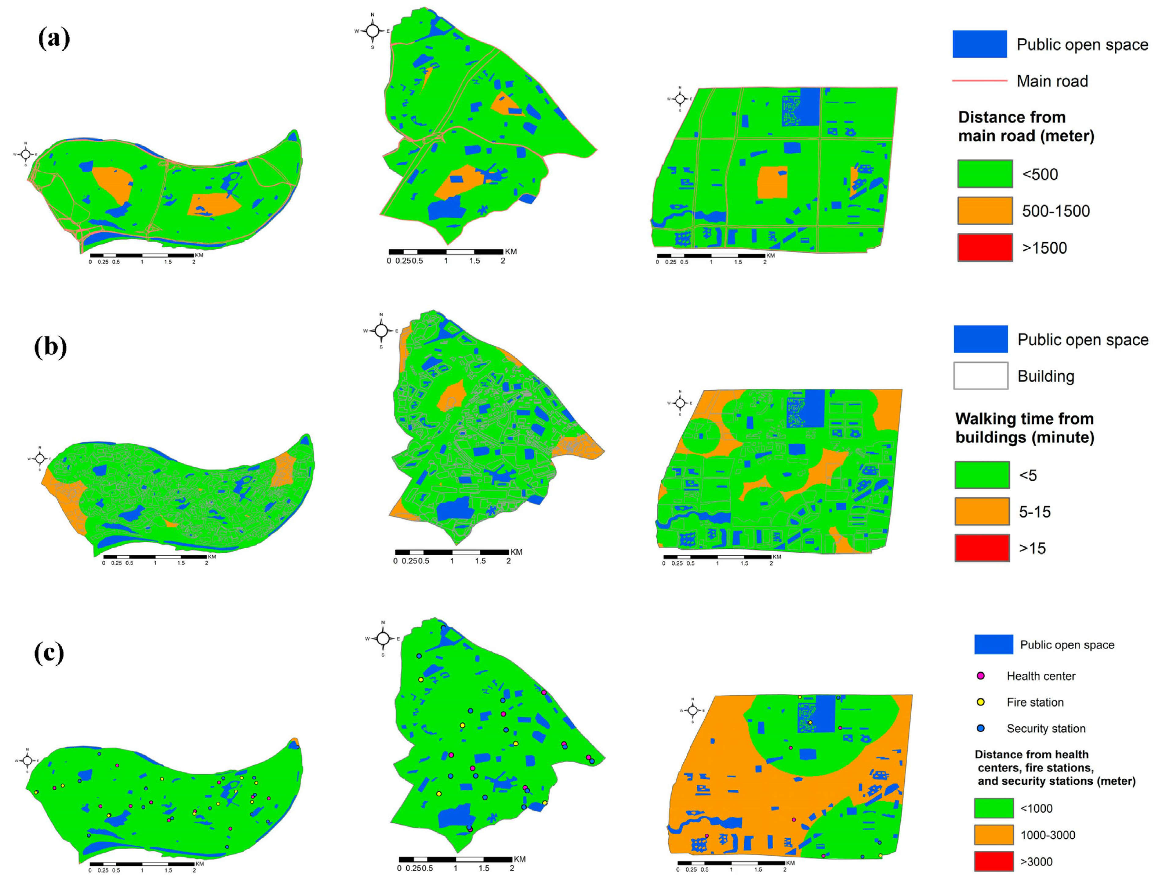
Regarding distance from main roads, most POSs in the three studied areas were less than 500 m away from the main roads, whereas some POSs in the middle parts of the studied areas were between 500 m and 1500 m away from the main roads (Figure 3a). The major difference between the three areas was in the nature of the roads. The university town was distinguished by its flat and wider roads, whereas the other studied areas had narrow roads and many bridges owing to the mountainous nature of those areas. Therefore, although the POSs met the accepted norms regarding the distance from main roads, the nature and width of the roads in the Yuzhong and old Shapingba areas may constitute a hindrance during earthquakes in terms of congestion when evacuating and the possibility of damaging some roads in the event of severe earthquakes.
In terms of walking time, which is an essential aspect of a quick and safe evacuation during earthquakes [68], the walking time to POSs varied between suitable (<5 min) and neutral (5–15 min) (Figure 3b). However, walking to POSs during earthquakes is affected by the nature of the walking paths. The university town had high-quality, flat, and wide walking paths. In contrast, in the old Shapingba and Yuzhong areas, the walking paths were of lower quality, steep-sloped, and narrow, especially in the parts far from the areas’ centers. This may lead to overcrowding and difficulties in using them during evacuation in cases of earthquakes, especially because these areas have a high population density.
Regarding the distance from service centers, which is a crucial aspect of accessibility during earthquakes [44], the POSs in the Yuzhong and old Shapingba areas were suitable for service facilities. In the university town area, the POSs of the northern and southeastern parts were in suitable locations for the service facilities, whereas the rest of the POSs in that area were in neutral locations (Figure 3c).

3.1.2. Efficiency

Efficiency was measured by examining the POSs’ usable sizes and their capacities to accommodate refugees and comparing their capacities to the area’s population. The results (Figure 4) showed that, out of the total of 169 POSs in the three studied areas, there were only 5 POSs with a usable area of more than 50,000 m2 that could be used as long-term shelters according to China’s national standards for emergency shelters construction [42]. One of them was located in the Yuzhong district area, one in the old Shapingba area, and three in the university town area. There were also 142 POSs with a usable area of 2000–50,000 m2. They could be used as temporary shelters, 30 of which were located in the Yuzhong district area, 53 in the old Shapingba area, and 59 in the university town area. Twenty-two POSs were smaller than 2000 m2. They would only be usable as emergency shelters; 12 were located in the Yuzhong district area, 7 in the old Shapingba area, and 3 in the university town area.
The results demonstrated that the efficiency of POSs for earthquake sheltering depended on the earthquake’s intensity. In the worst situations, when the earthquake is very severe and all residents need to leave their homes [89], the current POSs are not sufficient for shelter, especially in the Yuzhong area. The results in Table 4 show that the POSs for emergency shelters in the Yuzhong district could cover 6% of the total population of the area, which accounts for 377,613 people [73]. The POSs for temporary shelters would be sufficient for 91%, whereas the POSs for long-term shelter would cover 3% of the total population, according to the urban planning and construction codes in China [43].
In the old Shapingba area, the POSs for emergency shelters would cover 9% of the total population, accounting for 213,134 people [74]. The POSs for long-term shelters would be sufficient for 9%, whereas the POSs for temporary shelters would cover more than twice the area’s population.
In the university town area of 186,449 people [74], the POSs for emergency shelters would cover 5% of the area’s total population, the POSs for long-term shelters would be sufficient for 36%, and the POSs of temporary shelters would cover nearly three times the area’s population.
On the contrary, if an earthquake is mild, the earthquake damage would not be very serious and there would be no need for long-term shelter; thus, the current POSs would be sufficient to provide emergency and temporary shelter for earthquake-affected people in all of the studied areas. Long-term shelters could be used for temporary and emergency shelters.

3.1.3. Safety

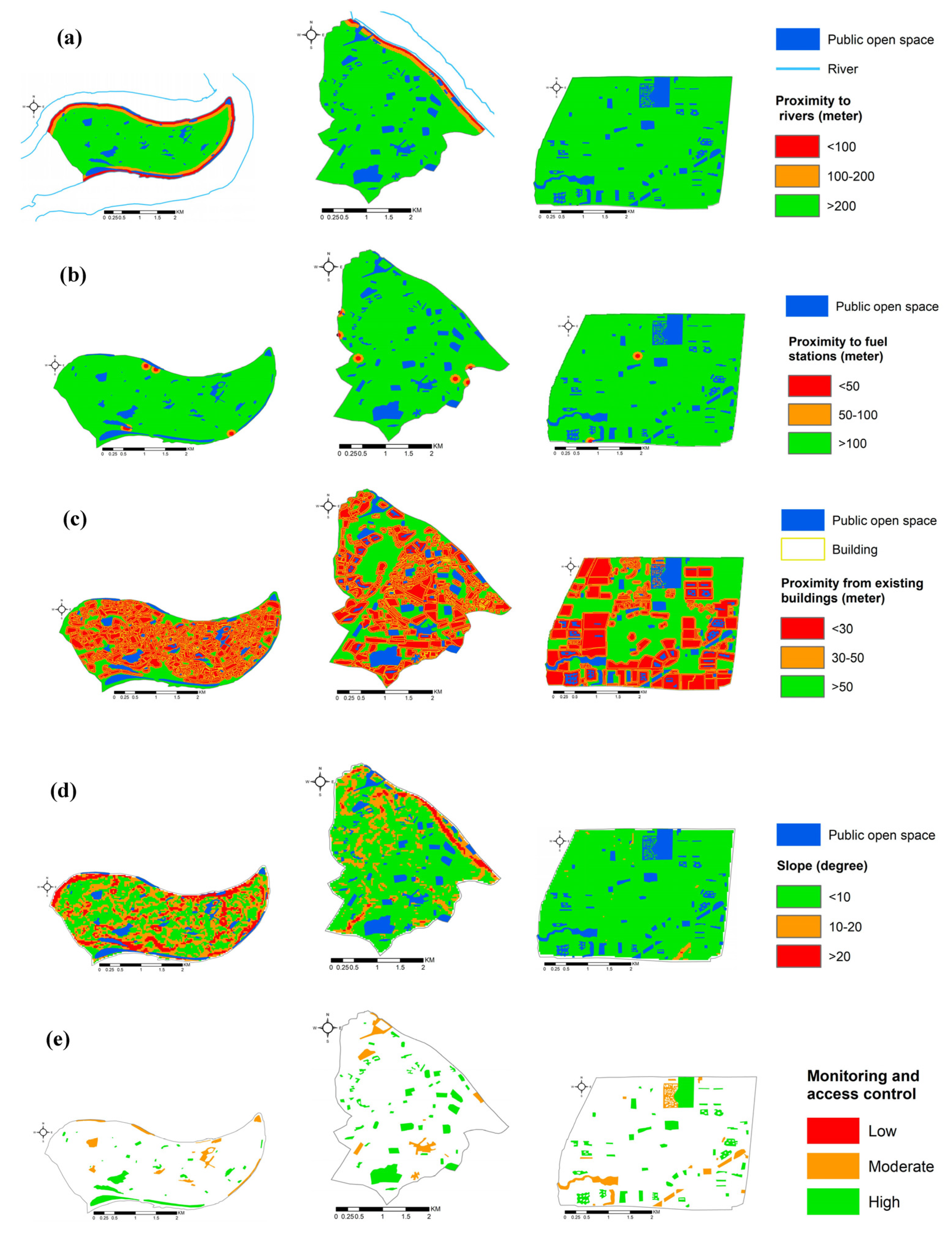
Safety was studied by analyzing factors that may cause secondary hazards, including proximity to flood sources, proximity to fuel stations, building collapse hazard, slope, and monitoring and access control. The results indicate that the risk of building collapse is the greatest safety threat to using POSs during earthquakes in all of the studied areas, given the very close location of some types of POSs to the high-rise and dense buildings that characterize Chongqing. The results in Figure 5c show that all of the residential block parks are unsafe from the building collapse risk as they are directly connected to high-rise buildings. The results also showed some squares and sports fields in unsafe locations, especially in central areas. Public parks and waterfronts would be safe as they are far away from the existing buildings.
In terms of proximity to rivers, the Yuzhong area is surrounded by rivers on three sides and the old Shapingba area has river borders on the eastern side. The waterfronts in the Yuzhong and old Shapingba areas, and public parks and the square in the southern and northeastern parts of the Yuzhong area, respectively, are in unsafe locations from the danger of river flooding that may occur as a result of an earthquake. Nevertheless, the majority of POSs are in safe zones from the risk of river flooding. Concerning the university town, all POSs are safe from the danger of flooding, as they are far from the rivers (Figure 5a) (Figure 1 shows the university town’s location to the rivers).
Regarding the proximity to fuel stations, Chongqing’s policy is based on setting up fuel stations away from densely populated central sites. Most of the studied POSs are located in safe places from any hazards that may come from gas stations during earthquakes. A few POSs are within a neutral distance from fuel stations. However, due to the geographical nature of Chongqing, these POSs were considered safe enough (Figure 5b).
Considering the slope factor, despite the mountainous nature of Chongqing, most POSs were built on almost flat land. Most of the POSs in the Yuzhong area are flat or slightly sloping. In contrast, some POSs are located at steeply sloping levels, such as some public parks. In the old Shapingba area, all the POSs are between flat and slightly sloping. On the contrary, all POSs in the university town are located on flat lands (Figure 5d).
In terms of ensuring security inside the POSs, Chongqing is characterized by good monitoring throughout the city. All POSs in the three study areas were characterized by moderate to high degrees of monitoring and access control safety. Public parks, residential block parks, and sports fields are characterized by high degrees of security, whereas squares and waterfronts are at a moderate level as they lack access control (Figure 5e).

3.1.4. Multifunctionality

Multifunctionality was examined through three sub-criteria: services, presence of large and dense trees, and daily use. The results show that multifunctionality was not well integrated with the planning and design of the existing POSs in Chongqing. Only very few POSs in all studied areas could perform perfect multiple functions; most could not.
In terms of services, only a few POSs have a high level of services, and most of them are in the Yuzhong district area. Some POSs have low levels of services, and most of them are in the university town area. The majority of POSs in all the studied areas have moderate levels of services (Figure 6a).
Concerning the presence of high levels of large and dense trees in POSs that affect the ability of POSs to perform multiple functions and may hinder construction and reduce the number of shelters in the POS [71], all squares, sports fields, and waterfronts have low levels of dense and high trees. Most residential block parks have moderate levels of large and dense trees; however, some residential block parks in the old Shapingba area have high levels of large and dense trees. Most of the high levels of large and dense trees are found in public parks, especially in the Yuzhong area (Figure 6b).
Regarding the daily use of POSs, the large squares and residential block parks in all study areas have high daily use owing to the high quality of these spaces and the availability of entertainment factors within them. The daily use of the remaining POSs varies between high, moderate, and low levels based on the attractive factors available in the spaces (Figure 6c).

3.2. Measuring the Resilience Degree of POSs

The results of the weighted overlay method in GIS (Figure 7) show different degrees of resilience based on the area characteristics and POS type. The degree of resilience ranges between suitable (indicated by the number 2 on the maps) and neutral (indicated by the number 1 on the maps). Regarding the levels of the areas, the university town area, which has a flat geographic nature, newly established POS network, and lower population density compared with the other areas, has the most earthquake-resilient POSs, followed by the old Shapingba area. The Yuzhong district area, with the most complex geographic nature and highest population density, has the fewest earthquake-resilient POSs. Regarding the level of POS types, public parks, squares, and sports fields are the most resilient compared with residential block parks and waterfronts.

3.3. Need to Improve Earthquake Resilience in POSs

The results indicate that the existing levels of resilience in the studied POSs are insufficient to deal effectively with earthquakes, especially major ones that may hit Chongqing at any time. Moreover, Chongqing is a densely populated and rapidly urbanizing area with a complex geographical nature, so the earthquake losses may be huge. Rethinking how to improve resilience to earthquakes in the POSs in Chongqing is necessary to reduce the losses if an earthquake happens.
Although the Ministry of Housing and Urban–Rural Development of the People’s Republic of China provided strategies and determined norms for planning and designing against disasters [42,43], the planners and decision-makers in Chongqing did not consider earthquakes much in the planning and design of POSs. The most-current focus is on constructing earthquake-resistant buildings and structures. Developing a systematic planning program for earthquake preparedness in POSs is crucial, and it must be constantly improved as an essential public policy.
This study proposes distinctive guidance to planners and decision-makers in Chongqing for enhancing the earthquake resilience of POSs. The recommendations can be summarized as follows:
  • Improve the accessibility network by taking into account the geographical characteristics of the area to ensure rapid access to POSs during earthquakes and avoid disturbances in transportation and evacuation that increase losses caused by earthquakes.
  • Create more POSs by considering the equity in the distribution of POSs between the various areas according to the population density to ensure the ability of POSs to accommodate those affected by the earthquake in the neighboring areas.
  • Take safety priority into account when selecting POSs’ locations to avoid secondary hazards following earthquakes, especially the building collapse hazard, which is the greatest safety threat to using Chongqing’s POSs during earthquakes.
  • Enhance services in POSs to increase their daily use and provide the basic needs of refugees affected by the earthquake. The response of POSs to earthquakes is more effective if they are incorporated into daily life [70].
  • Given the rapid urbanization and continual adjustments in Chongqing, it is suggested to re-evaluate POSs every five years.

4. Conclusions

Accepting crises as new truths and developing strategies to work in such disturbances is necessary for cities worldwide. Considering the increasing human and economic losses following earthquake disasters, this study calls for the assurance of resilience as a fundamental measure to face earthquakes. Previous studies show that POSs have great potential to ensure resilience to earthquakes in cities [6,7,8]. In addition, the literature confirms the important role of urban planning in creating earthquake-resilient POSs [2,13,19,20,21,22,23]. However, a research gap exists in planning earthquake-resilient POSs.
This study aims to fill the gap through two main points. First, it presents and explains the resilience criteria that can be incorporated into planning and designing POSs. This study explores four main resilience criteria consisting of 12 sub-criteria that ensure the effective response of POSs to earthquakes. They are (1) accessibility, which includes the distance and nature of the main roads, walking time and nature of walking paths, and distance from service centers; (2) efficiency, measured by the usable size of POSs and calculated capacity for sheltering; (3) safety, which includes proximity to flood sources, proximity to fuel stations, building collapse hazard, slope, and monitoring and access control; and (4) multifunctionality, which includes services, the presence of large and dense trees, and daily use. Second, the study applies the resilience criteria to the POSs in three areas of Chongqing to evaluate their resilience degree and determine their ability to respond effectively to earthquakes.
The results show that the degree of earthquake resilience of the POSs differs according to the area and POS type. The area with a flat geographic nature and lower population density has the most earthquake-resilient POSs. In contrast, the area with the most complex geographic nature and highest population density has the fewest earthquake-resilient POSs. Public parks, squares, and sports fields are the most resilient compared with residential block parks and waterfronts. Generally, the levels of resilience in the studied areas are insufficient to respond effectively to earthquakes, especially if the earthquake is severe. Therefore, the enhancement of seismic resilience in Chongqing’s POSs is an urgent necessity.
This study is a valuable addition to the urban planning field as it provides important criteria and norms for planning and establishing POSs that ensure their effective response to earthquakes. Moreover, using GIS technology and integrating the analytic hierarchy process with weighted overlay analysis is an effective method for determining the resilience degree of POSs. It helps planners and decision-makers to determine the vulnerability in the existing POS networks and find solutions to enhance their earthquake resilience.
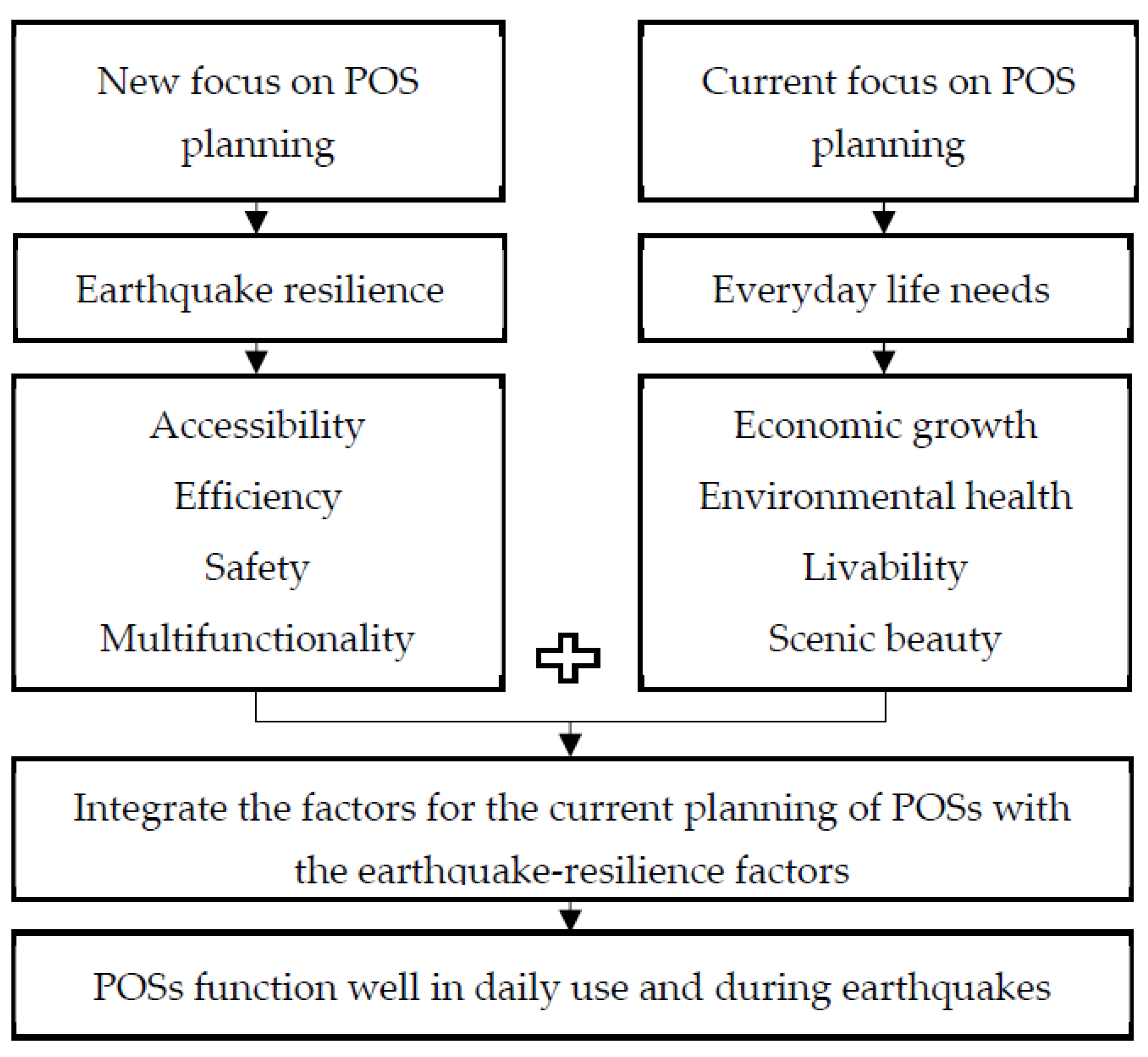
This study emphasizes the need for policymakers and urban planners to add a new focus to the current focus, which is on the scenic beauty, economic growth, environmental health, livability, walkability, and vitality of a city. Concentrating on resilience to earthquake disasters is essential. POSs should be planned and designed to function in daily life and during earthquakes by incorporating the current focus factors with the earthquake-resilience factors (Figure 8).

5. Limitations and Future Research Recommendations

This study is an important source for reducing cities’ vulnerabilities to earthquake disasters. However, it has some limitations. The case study is limited to the POSs of small areas in Chongqing, so the results are limited to the studied parts of Chongqing city. Nevertheless, the earthquake resilience criteria and norms can be implemented in other cities, especially those with similar characteristics, such as mountainous and densely populated cities.
Concerning the accessibility criteria, the study examined accessibility based on the distance and nature of factors. It did not investigate the damage state and the capacity of the existing road and pedestrian paths leading to POSs. These aspects are important, especially for mountainous and high-population-density areas, such as Chongqing, where transportation infrastructure is often poorer than that in other regions. These aspects will be examined in detail in future studies. Future work will also focus on applying the methodology to the other parts of Chongqing to increase the POSs’ resilience to earthquakes in the whole city. The study recommends expanding the investigation of POSs’ resilience to earthquakes in different cities to increase the knowledge of planning and designing earthquake-resilient POSs in cities with different characteristics.

Author Contributions

Conceptualization, M.A., D.C. and S.H.; Methodology, M.A., D.C. and S.H.; software, M.A.; Formal analysis, M.A.; Supervision, D.C.; Writing—original draft, M.A.; Review and editing, D.C. All authors have read and agreed to the published version of the manuscript.

Funding

This research was funded by National Natural Science Foundation of China, grant number 52078070.

Institutional Review Board Statement

Not applicable.

Informed Consent Statement

Not applicable.

Data Availability Statement

Data will be available upon request.

Conflicts of Interest

The authors declare no conflict of interest.

References

  1. Childers, D.L.; Cadenasso, M.L.; Grove, J.M.; Marshall, V.; McGrath, B.; Pickett, S.T. An ecology for cities: A transformational nexus of design and ecology to advance climate change resilience and urban sustainability. Sustainability 2015, 7, 3774–3791. [Google Scholar] [CrossRef] [Green Version]
  2. Hossain, N. Street’as accessible open space network in earthquake recovery planning in unplanned urban areas. Asian J. Humanit. Soc. Sci. 2014, 2, 103–115. [Google Scholar]
  3. Parizi, S.M.; Taleai, M.; Sharifi, A. A GIS-Based Multi-Criteria Analysis Framework to Evaluate Urban Physical Resilience against Earthquakes. Sustainability 2022, 14, 5034. [Google Scholar] [CrossRef]
  4. UNISDR. How Can We Make Earthquakes Less Deadly? Available online: https://www.undrr.org/ (accessed on 25 April 2022).
  5. World Bank; United Nations. Natural Hazards, Unnatural Disasters: The Economics of Effective Prevention; World Bank: Washington, DC, USA, 2010. [Google Scholar]
  6. Allan, P.; Bryant, M. Resilience as a framework for urbanism and recovery. J. Landsc. Archit. 2011, 6, 34–45. [Google Scholar] [CrossRef]
  7. Nigg, J.M.; Eisner, R.K. Earthquake response: Intergovernmental structure and policy innovation. In University of Delaware Disaster Research Center Preliminary Paper; Disaster Research Center: Newark, DE, USA, 1997. [Google Scholar]
  8. Masuda, N. Disaster refuge and relief urban park system in Japan. Landsc. Archit. Front. 2014, 2, 52–61. [Google Scholar]
  9. Allan, P.; Bryant, M. The attributes of resilience: A tool in the evaluation and design of earthquake-prone cities. Int. J. Disaster Resil. Built Environ. 2014, 5, 109–129. [Google Scholar] [CrossRef]
  10. Greely, A.W.; Maj, G. Earthquake in California, April 18, 1906: Special Report of Maj. Gen. Adolphus W. Greely, U.S.A., Commanding the Pacifc Division; The Bancroft Library: Berkeley, CA, USA; University of California: Berkeley, CA, USA, 1906. [Google Scholar]
  11. Villagra, P.; Rojas, C.; Ohno, R.; Xue, M.; Gómez, K. A GIS-base exploration of the relationships between open space systems and urban form for the adaptive capacity of cities after an earthquake: The cases of two Chilean cities. Appl. Geogr. 2014, 48, 64–78. [Google Scholar] [CrossRef]
  12. You, C.; Chen, X.; Yao, L. How China responded to the May 2008 earthquake during the emergency and rescue period. J. Public Health Policy 2009, 30, 379–394. [Google Scholar] [CrossRef]
  13. Allan, P.; Bryant, M.; Wirsching, C.; Garcia, D.; Teresa Rodriguez, M. The influence of urban morphology on the resilience of cities following an earthquake. J. Urban Des. 2013, 18, 242–262. [Google Scholar] [CrossRef]
  14. Chelleri, L. From the «Resilient City» to Urban Resilience. A review essay on understanding and integrating the resilience perspective for urban systems. Doc. D’anàlisi Geogràfica 2012, 58, 287–306. [Google Scholar] [CrossRef]
  15. Ribeiro, P.J.G.; Gonçalves, L.A.P.J. Urban resilience: A conceptual framework. Sustain. Cities Soc. 2019, 50, 101625. [Google Scholar] [CrossRef]
  16. Timmermann, P. Vulnerability, resilience and the collapse of society. Environ. Monogr. 1981, 1, 1–42. [Google Scholar]
  17. Sharifi, A. Urban resilience assessment: Mapping knowledge structure and trends. Sustainability 2020, 12, 5918. [Google Scholar] [CrossRef]
  18. Jayakody, R.; Amaratunga, D.; Haigh, R. The Use of Public Open Spaces for Disaster Resilient Urban Cities; IIIRR: Kandy, Sri Lanka, 2016. [Google Scholar]
  19. Villagra-Islas, P.; Alves, S. Open space and their attributes, uses and restorative qualities in an earthquake emergency scenario: The case of Concepción, Chile. Urban For. Urban Green. 2016, 19, 56–67. [Google Scholar] [CrossRef]
  20. Covatta, A.; Ikalović, V. Urban Resilience: A Study of Leftover Spaces and Play in Dense City Fabric. Sustainability 2022, 14, 13514. [Google Scholar] [CrossRef]
  21. UNISDR. Hyogo framework for action 2005–2015. Encycl. Earth Sci. Ser. 2005, 380, 508–516. [Google Scholar] [CrossRef]
  22. United Nations. The 2030 Agenda for Sustainable Development; United Nations: New York, NY, USA, 2015.
  23. UNISDR. Sendai Framework for Disaster Risk Reduction 2015–2030. Available online: http://www.wcdrr.org/uploads/Sendai_Framework_for_Disaster_Risk_Reduction_2015-2030.pdf (accessed on 10 June 2021).
  24. Koren, D.; Rus, K. The potential of open space for enhancing urban seismic resilience: A literature review. Sustainability 2019, 11, 5942. [Google Scholar] [CrossRef] [Green Version]
  25. Bryant, M.; Allan, P. Designing Regional Resilience. In Proceedings of the NZSEE Annual Technical Conference, Rotorua, New Zealand, 10–12 April 2015. [Google Scholar]
  26. Gould, P.R. Spatial Diffusion, Resource Paper No. 4; Association of American Geographers; Commission on College Geography: Washington, DC, USA, 1969. [Google Scholar]
  27. Chang, H.-S.; Liao, C.-H. Planning emergency shelter locations based on evacuation behavior. Nat. Hazards 2015, 76, 1551–1571. [Google Scholar] [CrossRef]
  28. Nicholls, S. Measuring the accessibility and equity of public parks: A case study using GIS. Manag. Leis. 2001, 6, 201–219. [Google Scholar] [CrossRef]
  29. Yin, H.; Xu, J. Measuring the accessibility of parks: A case study in Shanghai, China. In Proceedings of the 2009 Sixth International Conference on Fuzzy Systems and Knowledge Discovery, Tianjin, China, 14–16 August 2009; pp. 232–236. [Google Scholar]
  30. Caiado, G.; Macário, R.; Oliveira, C.S. A New Paradigm in Urban Road Network Seismic Vulnerability: From a Link-By-Link Structural Approach to an Integrated Functional Assessment. In Proceedings of the ISCRAM, Lisbon, Portugal, 8–11 May 2011; Available online: https://idl.iscram.org/files/caiado/2011/360_Caiado_etal2011.pdf (accessed on 15 February 2022).
  31. Lam, C.; Shimizu, T. A network analytical framework to analyze infrastructure damage based on earthquake cascades: A study of earthquake cases in Japan. Int. J. Disaster Risk Reduct. 2021, 54, 102025. [Google Scholar] [CrossRef]
  32. Cova, T.J.; Johnson, J.P. Microsimulation of neighborhood evacuations in the urban–wildland interface. Environ. Plan. A 2002, 34, 2211–2229. [Google Scholar] [CrossRef]
  33. Kar, B.; Hodgson, M.E. A GIS-based model to determine site suitability of emergency evacuation shelters. Trans. GIS 2008, 12, 227–248. [Google Scholar] [CrossRef]
  34. El-Maissi, A.M.; Argyroudis, S.A.; Kassem, M.M.; Leong, L.V.; Mohamed Nazri, F. An Integrated Framework for the Quantification of Road Network Seismic Vulnerability and Accessibility to Critical Services. Sustainability 2022, 14, 12474. [Google Scholar] [CrossRef]
  35. Macintyre, A.G.; Barbera, J.A.; Smith, E.R. Surviving collapsed structure entrapment after earthquakes: A “time-to-rescue” analysis. Prehosp. Disaster Med. 2006, 21, 4–17. [Google Scholar] [CrossRef]
  36. Gall, M. Where to go? Strategic modelling of access to emergency shelters in Mozambique. Disasters 2004, 28, 82–97. [Google Scholar] [CrossRef] [PubMed]
  37. Tai, C.-A.; Lee, Y.-L.; Lin, C.-Y. Earthquake disaster prevention area planning considering residents’ demand. In Proceedings of the 2010 2nd International Conference on Advanced Computer Control, Shenyang, China, 27–29 March 2010; pp. 381–385. [Google Scholar]
  38. Zhan, F.B.; Noon, C.E. Shortest path algorithms: An evaluation using real road networks. Transp. Sci. 1998, 32, 65–73. [Google Scholar] [CrossRef] [Green Version]
  39. Hamza-Lup, G.L.; Hua, K.A.; Lee, M.; Peng, R. Enhancing intelligent transportation systems to improve and support homeland security. In Proceedings of the 7th International IEEE Conference on Intelligent Transportation Systems (IEEE cat. No. 04TH8749), Washington, WA, USA, 3–6 October 2004; pp. 250–255. [Google Scholar]
  40. Jotshi, A.; Gong, Q.; Batta, R. Dispatching and routing of emergency vehicles in disaster mitigation using data fusion. Socio-Econ. Plan. Sci. 2009, 43, 1–24. [Google Scholar] [CrossRef]
  41. Uno, K.; Kashiyama, K. Development of simulation system for the disaster evacuation based on multi-agent model using GIS. Tsinghua Sci. Technol. 2008, 13, 348–353. [Google Scholar] [CrossRef]
  42. Ministry of Housing and Urban-Rural Development of the People’s Republic of China. Standard for Urban Planning on Comprehensive Disaster Resistance and Prevention (GB/T 51327-2018). Available online: https://www.mohurd.gov.cn/gongkai/fdzdgknr/tzgg/201903/20190320_239841.html (accessed on 27 April 2022). (In Chinese)
  43. Ministry of Housing and Urban-Rural Development of the People’s Republic of China. Code for Design of Disasters Mitigation Emergency Congregate Shelter (GB 51143-2015). Available online: https://www.mohurd.gov.cn/gongkai/fdzdgknr/zfhcxjsbwj/202205/20220510_765998.html (accessed on 12 April 2022). (In Chinese)
  44. Wang, X. Research on the Suitability of the Emergency Shelter in Tianjin. In Proceedings of the 5th Annual International Conference on Social Science and Contemporary Humanity Development (SSCHD 2019), Wuhan, China, 15–16 November 2019; pp. 121–126. [Google Scholar]
  45. Zhao, L.; Li, H.; Sun, Y.; Huang, R.; Hu, Q.; Wang, J.; Gao, F. Planning emergency shelters for urban disaster resilience: An integrated location-allocation modeling approach. Sustainability 2017, 9, 2098. [Google Scholar] [CrossRef] [Green Version]
  46. Dionísio, M.R. The Importance of Public Space for Sustainable Urban Rehabilitation. In Proceedings of the Constructed Environment International Conference, Tokyo, Japan, 17–19 November 2010. [Google Scholar]
  47. Ishikawa, M. Landscape planning for a safe city. Ann. Geophys. 2002, 45, 833–841. [Google Scholar] [CrossRef]
  48. Chou, J.-S.; Ou, Y.-C.; Cheng, M.-Y.; Lee, C.-M. Emergency shelter capacity estimation by earthquake damage analysis. Nat. Hazards 2013, 65, 2031–2061. [Google Scholar] [CrossRef]
  49. Johnson, C. Strategic planning for post-disaster temporary housing. Disasters 2007, 31, 435–458. [Google Scholar] [CrossRef]
  50. Lizarralde, G.; Johnson, C.; Davidson, C. Rebuilding after Disasters: From Emergency to Sustainability; Routledge: London, UK, 2009. [Google Scholar]
  51. Félix, D.; Branco, J.M.; Feio, A. Temporary housing after disasters: A state of the art survey. Habitat Int. 2013, 40, 136–141. [Google Scholar] [CrossRef]
  52. Kreimer, A. Emergency, temporary and permanent housing after disasters in developing countries. Ekistics 1979, 46, 361–365. [Google Scholar]
  53. Liangxin, F.; Sha, X.; Guobin, L. Patterns and its disaster shelter of urban green space: Empirical evidence from Jiaozuo city, China. Afr. J. Agric. Res. 2012, 7, 1184–1191. [Google Scholar] [CrossRef]
  54. Tong, Z.; Zhang, J.; Liu, X. GIS-based design of urban emergency shelter in Songbei Harbin. In Recent Advances in Computer Science and Information Engineering; Springer: Berlin/Heidelberg, Germany, 2012; pp. 617–622. [Google Scholar]
  55. Sphere Association. Sphere Handbook: Humanitarian Charter and Minimum Standards in Humanitarian Response; Practical Action: Geneva, Switzerland, 2018. [Google Scholar]
  56. Sanderson, D.; Burnell, J. Beyond Shelter after Disaster: Practice, Process and Possibilities; Routledge: London, UK, 2013. [Google Scholar]
  57. Quarantelli, E.L. Patterns of sheltering and housing in US disasters. Disaster Prev. Manag. Int. J. 1995, 4, 43–53. [Google Scholar] [CrossRef]
  58. Chen, W.; Zhai, G.; Ren, C.; Shi, Y.; Zhang, J. Urban resources selection and allocation for emergency shelters: In a multi-hazard environment. Int. J. Environ. Res. Public Health 2018, 15, 1261. [Google Scholar] [CrossRef] [Green Version]
  59. Song, Y.; Xie, K.; Su, W. Mechanism and strategies of post-earthquake evacuation based on cellular automata model. Int. J. Disaster Risk Reduct. 2019, 34, 220–231. [Google Scholar] [CrossRef]
  60. Soltani, A.; Ardalan, A.; Boloorani, A.D.; Haghdoost, A.; Hosseinzadeh-Attar, M.J. Site selection criteria for sheltering after earthquakes: A systematic review. PLoS Curr. 2014, 6, 1–12. [Google Scholar] [CrossRef] [Green Version]
  61. Liu, K. GIS-based MCDM framework combined with coupled multi-hazard assessment for site selection of post-earthquake emergency medical service facilities in Wenchuan, China. Int. J. Disaster Risk Reduct. 2022, 73, 102873. [Google Scholar] [CrossRef]
  62. McGlynn, S.; Smith, G.; Alcock, A.; Murrain, P.; Bentley, I. Responsive Environments; Routledge: London, UK, 2013. [Google Scholar]
  63. Ghavampour, E. The Contribution of Natural Design Elements to the Sustained Use of Public Space in a City Centre; Victoria University of Wellington: Wellington, New Zealand, 2014. [Google Scholar]
  64. Tucker, P.; Gilliland, J.; Irwin, J.D. Splashpads, swings, and shade. Can. J. Public Health 2007, 98, 198–202. [Google Scholar] [CrossRef] [PubMed]
  65. Lloyd, K.; Burden, J.; Kiewa, J. Young Girls and Urban Parks: Planning for Transition Through Adolescence. J. Park Recreat. Adm. 2008, 26, 21–38. [Google Scholar]
  66. Ries, A.V.; Voorhees, C.C.; Roche, K.M.; Gittelsohn, J.; Yan, A.F.; Astone, N.M. A quantitative examination of park characteristics related to park use and physical activity among urban youth. J. Adolesc. Health 2009, 45, S64–S70. [Google Scholar] [CrossRef] [PubMed]
  67. Carmona, M.; De Magalhaes, C.; Hammond, L. Public Space: The Management Dimension; Routledge: London, UK, 2008. [Google Scholar]
  68. León, J.; March, A. Urban morphology as a tool for supporting tsunami rapid resilience: A case study of Talcahuano, Chile. Habitat Int. 2014, 43, 250–262. [Google Scholar] [CrossRef]
  69. Selman, P. Planning for landscape multifunctionality. Sustain. Sci. Pract. Policy 2009, 5, 45–52. [Google Scholar] [CrossRef]
  70. Mazereeuw, M.; Yarina, E. Emergency preparedness hub: Designing decentralized systems for disaster resilience. J. Archit. Educ. 2017, 71, 65–72. [Google Scholar] [CrossRef]
  71. Turer Baskaya, F.A. Disaster sensitive landscape planning for the coastal megacity of Istanbul. J. Coast. Conserv. 2015, 19, 729–742. [Google Scholar] [CrossRef]
  72. Chongqing Municipal Bureau of Statistics. The Statistical Bulletin of Chongqing’s National Economic and Social Development. 2021. Available online: https://m.gmw.cn/baijia/2022-03/18/1302851649.html (accessed on 17 May 2022). (In Chinese).
  73. Statistics Bureau of Yuzhong District, Chongqing. The National Population Census of Yuzhong District, Chongqing. 2021. Available online: http://www.cqyz.gov.cn/bm_229/qtjj/zwgk_97157/fdzdgknr_97159/tjxx_97164/202109/t20210918_9731956.html?UG8KLH=E6NKOC (accessed on 17 May 2022). (In Chinese)
  74. Statistics Bureau of Shapingba District, Chongqing. The National Population Census of Shapingba District, Chongqing. 2021. Available online: http://www.cqspb.gov.cn/bm/qtjj_64050/zwgk_64054/fdzdgknr_64056/tjzl/tjgb/202107/t20210701_9440993.html (accessed on 17 May 2022). (In Chinese)
  75. Clarke, K.C. Analytical and Computer Cartography; Prentice Hall: Englewood Cliffs, NJ, USA, 1995. [Google Scholar]
  76. Kakumoto, S.; Kosugi, Y.; Hatayama, M.; Kameda, H. Development of spatial temporal geographic information system and risk adaptive regional management information system-toward development of GIS based on Asian culture for disaster prevention. In Proceedings of the 41st SICE Annual Conference, Osaka, Japan, 5–7 August 2002; SICE 2002: New York, NY, USA, 2010; pp. 352–357. [Google Scholar]
  77. Saaty, T.L. Decision making with the analytic hierarchy process. Int. J. Serv. Sci. 2008, 1, 83–98. [Google Scholar] [CrossRef] [Green Version]
  78. Zabihi, H.; Alizadeh, M.; Kibet Langat, P.; Karami, M.; Shahabi, H.; Ahmad, A.; Nor Said, M.; Lee, S. GIS Multi-Criteria Analysis by Ordered Weighted Averaging (OWA): Toward an integrated citrus management strategy. Sustainability 2019, 11, 1009. [Google Scholar] [CrossRef] [Green Version]
  79. Rana, V.K.; Suryanarayana, T.M.V. GIS-based multi criteria decision making method to identify potential runoff storage zones within watershed. Ann. GIS 2020, 26, 149–168. [Google Scholar] [CrossRef] [Green Version]
  80. de Brito, M.M.; Evers, M. Multi-criteria decision-making for flood risk management: A survey of the current state of the art. Nat. Hazards Earth Syst. Sci. 2016, 16, 1019–1033. [Google Scholar] [CrossRef] [Green Version]
  81. Şenik, B.; Uzun, O. An assessment on size and site selection of emergency assembly points and temporary shelter areas in Düzce. Nat. Hazards 2021, 105, 1587–1602. [Google Scholar] [CrossRef]
  82. Junian, J.; Azizifar, V. The evaluation of temporary shelter areas locations using geographic information system and analytic hierarchy process. Civ. Eng. J. 2018, 4, 1678–1688. [Google Scholar] [CrossRef]
  83. Nuthammachot, N.; Stratoulias, D. Multi-criteria decision analysis for forest fire risk assessment by coupling AHP and GIS: Method and case study. Environ. Dev. Sustain. 2021, 23, 17443–17458. [Google Scholar] [CrossRef]
  84. Aman, D.D.; Aytac, G. Multi-criteria decision making for city-scale infrastructure of post-earthquake assembly areas: Case study of Istanbul. Int. J. Disaster Risk Reduct. 2022, 67, 102668. [Google Scholar] [CrossRef]
  85. Hoque, M.A.-A.; Tasfia, S.; Ahmed, N.; Pradhan, B. Assessing spatial flood vulnerability at Kalapara Upazila in Bangladesh using an analytic hierarchy process. Sensors 2019, 19, 1302. [Google Scholar] [CrossRef] [Green Version]
  86. Ramanathan, R. Data envelopment analysis for weight derivation and aggregation in the analytic hierarchy process. Comput. Oper. Res. 2006, 33, 1289–1307. [Google Scholar] [CrossRef]
  87. Mabahwi, N.A.B.; Bhattacharya, Y.; Nakamura, H. GIS-based multi-criteria analysis to identify site suitability of flood shelters in Kuantan, Malaysia. In Proceedings of the IOP Conference Series: Earth and Environmental Science, Surabaya, Indonesia, 30 November 2020; p. 012027. [Google Scholar]
  88. Şentürk, E.; Erener, A. Determination of temporary shelter areas in natural disasters by gis: A case study, Gölcük/Turkey. Int. J. Eng. Geosci. 2017, 2, 84–90. [Google Scholar] [CrossRef] [Green Version]
  89. Anhorn, J.; Khazai, B. Open space suitability analysis for emergency shelter after an earthquake. Nat. Hazards Earth Syst. Sci. 2015, 15, 789–803. [Google Scholar] [CrossRef]
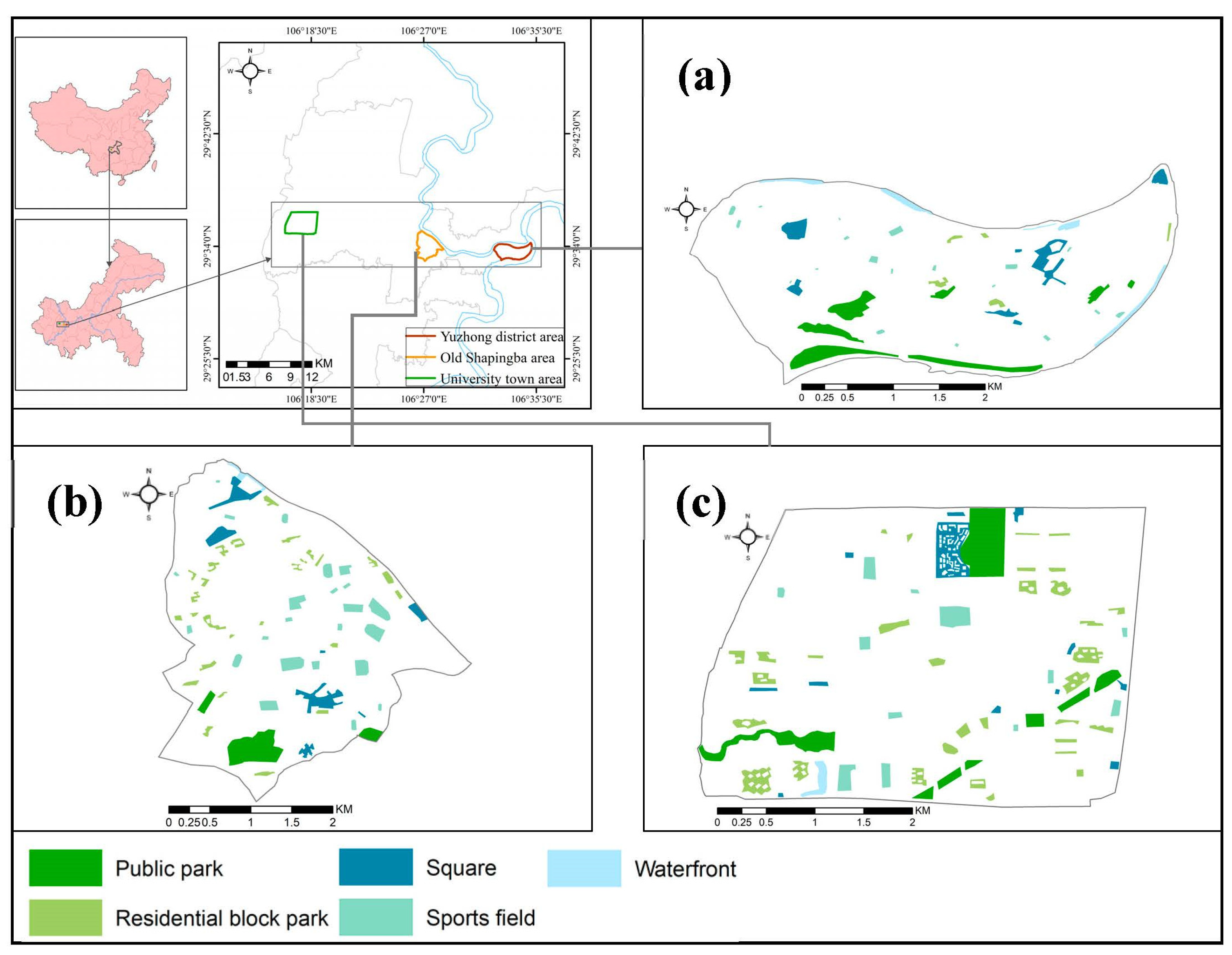
Figure 1. Location of the studied areas (top left) and their public open space (POS) types: (a) Yuzhong district area; (b) old Shapingba area; (c) University town area.
Sustainability 15 01092 g001
Figure 3. Accessibility criteria: (a) distance from main road; (b) walking time; (c) distance from service centers.
Sustainability 15 01092 g003
Figure 4. Usable size of POSs.
Sustainability 15 01092 g004
Figure 5. Safety criteria: (a) proximity to rivers; (b) proximity to fuel stations; (c) proximity to existing buildings; (d) slope; (e) monitoring and access control.
Sustainability 15 01092 g005
Figure 6. Multifunctionality criteria: (a) services; (b) large and dense trees; (c) daily use.
Sustainability 15 01092 g006
Figure 7. The earthquake-resilience degrees of POSs.
Sustainability 15 01092 g007
Figure 8. Framework for planning earthquake-resilient POSs.
Sustainability 15 01092 g008
Table 1. Suitability criteria for earthquake-resilient POSs. (norms are developed based on the results of interviews with experts and in line with Chinese national standards for urban planning and construction of disaster shelters [42,43]).
Main CriteriaSub-CriteriaNormDescription
AccessibilityDistance from main roads<500 mSuitable
500–1500 mNeutral
>1500 mVulnerable
Walking time from buildings<5 minSuitable
5–15 mNeutral
>15 mVulnerable
Distance from service centers<1000 mSuitable
1000–3000 mNeutral
>3000 mVulnerable
EfficiencyUsable size<2000 m2Emergency shelter
2000–50,000 m2Temporary shelter
>50,000 m2Long term shelter
SafetyProximity to flood sources<100 mVulnerable
100–200 mNeutral
>200 mSuitable
Proximity to fuel stations<50 mVulnerable
50–100 mNeutral
>100 mSuitable
Building collapse hazards<30 mVulnerable
30–50 mNeutral
>50 mSuitable
Slope<10°Suitable
10–20°Neutral
>20°Vulnerable
Monitoring and access controlLowVulnerable
ModerateNeutral
HighSuitable
MultifunctionalityServicesLowVulnerable
ModerateNeutral
HighSuitable
Presence of large and dense trees LowSuitable
ModerateNeutral
HighVulnerable
Daily useLowVulnerable
ModerateNeutral
HighSuitable
Table 2. AHP pairwise comparison matrix (see Table 3 for the meanings of the codes).
A1A2A3ES1S2S3S4S5M1M2M3
A110.251.000.250.250.250.250.501.000.500.500.50
A24.0014.001.001.001.001.002.004.002.002.002.00
A31.000.2510.250.250.250.250.501.000.500.500.50
E4.001.004.0011.001.001.002.004.002.002.002.00
S14.001.004.001.0011.001.002.004.002.002.002.00
S24.001.004.001.001.0011.002.004.002.002.002.00
S34.001.004.001.001.001.0012.004.002.002.002.00
S42.000.502.000.500.500.500.5012.001.001.001.00
S51.000.251.000.250.250.250.250.5010.500.500.50
M12.000.502.000.500.500.500.501.002.0011.001.00
M22.000.502.000.500.500.500.501.002.001.0011.00
M32.000.502.000.500.500.500.501.002.001.001.001
Table 3. Earthquake-resilience criteria and their weights.
Resilience CriteriaWeightsCodeSub-CriteriaLocal WeightsGlobal Weights
Accessibility0.193A1Distance from main road0.16580.032
A2Walking time from buildings0.6680.129
A3Distance from service centers0.16580.032
Efficiency0.129EUsable size0.1290.129
Safety0.484S1Proximity to flood sources0.26650.129
S2Proximity to fuel stations0.26650.129
S3Building collapse hazard0.26650.129
S4Slope 0.1340.065
S5Monitoring and access control0.0660.032
Multi-
functionality
0.195M1Services0.3330.065
M2Presence of large and dense trees0.3330.065
M3Daily use0.3330.065
Table 4. Efficiency of POSs.
Emergency ShelterTemporary ShelterLong Term Shelter
POS Usable Size (m2)Capacity (People)POS Usable Size (m2)Capacity (People)POS Usable Size (m2)Capacity (People)
Yuzhong11,071.522,143345,018.8345,01865,543.114,565
Old Shapingba9903.119,806549,611.6549,61186,76519,281
University town4896.49792558,129558,129304,882.467,751
Disclaimer/Publisher’s Note: The statements, opinions and data contained in all publications are solely those of the individual author(s) and contributor(s) and not of MDPI and/or the editor(s). MDPI and/or the editor(s) disclaim responsibility for any injury to people or property resulting from any ideas, methods, instructions or products referred to in the content.