
Metro System Inundation in Zhengzhou, Henan Province, China

1
Department of Civil and Environmental Engineering, College of Engineering, Shantou University, Shantou 515063, China
2
MOE Key Laboratory of Intelligent Manufacturing Technology, College of Engineering, Shantou University, Shantou 515063, China
3
Department of Civil Engineering, Shanghai Jiao Tong University, Shanghai 200240, China
*
Author to whom correspondence should be addressed.
Sustainability 2022, 14(15), 9292; https://doi.org/10.3390/su14159292
Submission received: 10 June 2022
/
Revised: 13 July 2022
/
Accepted: 25 July 2022
/
Published: 29 July 2022
(This article belongs to the Section Hazards and Sustainability)
Abstract
:In this study, we investigated the flooding accident that occurred on Metro Line 5 in the capital city of Zhengzhou, Henan Province, China. On 20 July 2021, owing to an extreme rainstorm, serious inundation occurred in the Wulongkou parking lot of Zhengzhou Metro Line 5 and its surrounding area. Flooding forced a train to stop during operation, resulting in 14 deaths. Based on our preliminary investigation and analysis of this accident, we designed three main control measures to reduce the occurrence of similar accidents and mitigate the impact of similar accidents in the future, given the increasing number of extreme storm weather events in recent years: (1) to conduct subway flood risk assessments and to establish an early warning system, involving real-time monitoring of meteorological information during subway operation and construction; (2) to improve subway flood control emergency plans and to establish a response mechanism for subway flooding; and (3) to strengthen safety awareness training to ensure the orderly evacuation of people after accidents.
1. Introduction
With the rapid development of cities and underground spaces, the relationship between human society and the natural environment has increasingly deepened, with human society increasingly affecting the natural environment. The rapid urbanization process and rain island and heat island effects caused by rapid population growth have increased the frequency and intensity of extreme rainfall in large and medium cities. Factors such as the decline in the water storage rate caused by urban expansion and insufficient capacity system drainage have accelerated the frequency of urban waterlogging disasters, posing serious risks to urban safety, especially in underground spaces and underground transportation systems. For example, in June 1996, after heavy rainfall with an average hourly precipitation of 60 mm, many subway lines in Fukuoka flooded, causing casualties and property losses. With the acceleration of urbanization in China, many places have encountered heavy rainfall that has triggered floods, especially in coastal cities, such as Shanghai, Guangzhou, Shenzhen, and Yancheng [1]. On 10 May 2016, a mountain torrent caused by an extreme rainstorm entered the Guangzhou subway tunnel, resulting in the flooding of several subway stations. Although the government had emergency plans and thought they had adequately prepared, the incident on 10 May caused catastrophic damage to subway equipment, resulting in a direct economic loss of RMB 543.8 million. The serious losses caused by the flood event forced the government to re-evaluate the antiponding capacity and resilience of subway lines under rainstorm conditions.
Rainstorm and flood disaster risk assessment can generally be divided into three types, namely predisaster assessment, monitoring assessment during a disaster, and postdisaster measurement assessment. The main work of predisaster risk assessment contains setting assessment indicators and classifying risk levels. Nowadays, it is popular to use Geographic Information Systems (GIS), satellite, and remote sensing data to carry out disaster vulnerability assessments and risk assessments. For instance, Ogato et al. (2020) evaluated the flooding hazard and risk in Ambo town based on GIS and used a multicriteria perspective to examine its watershed [2]. Kim et al. (2018) used a regional travel demand model to assess the flooding risk for the transportation system in Honolulu. At present, the risk assessment of rainstorm and flood disasters mainly considers factors such as precipitation, water system, and population [3]. It should be noted that the spatial distribution of the water system and population changes little in a short period, while the rainfall in the spatial distribution is always much different, which has a greater impact on the assessment results.
Due to the frequent occurrence of extreme weather in the world in recent years, different countries have put forward their requirements for the safety of underground projects. Although many studies have been conducted on subway system flood assessment and other aspects, studies on related topics as in the present study are lacking [4]. However, the lack of cases and data makes it difficult to carry out relevant research. This study conducted a preliminary investigation on the water inflow incident in the Zhengzhou metro, providing a simple reference for other researchers to carry out relevant research.
On 20 July 2021, an extreme rainstorm struck Zhengzhou City in Henan Province, China. (Figure 1). Torrential rain in Zhengzhou resulted in 292 casualties: 39 people drowned in the underground space, including 12 people on Metro Line 5, 6 people in the Jingguang Road Tunnel, and 10 other victims, as shown in Figure 2 [5]. At approximately 14:00 on 24 July and 06:30 on 25 July, two more victims were found.
This article aimed to conduct a preliminary investigation of the water ingress accident caused by extreme rainstorms on Zhengzhou Metro Line 5 in Zhengzhou City, Henan Province, China. First, we provide a background of the disaster; second, we systematically describe subway flooding incidents and rescue operations. Finally, we discuss the potential causes of subway flooding accidents and provide targeted countermeasures, such as intelligent methods.
2. Background and Accident
2.1. Background
Zhengzhou has played an important role in the economic development of Henan Province. As an important city and comprehensive transportation hub in the center of the province, Zhengzhou has location advantages [10]. Zhengzhou City is located at the intersection of the Longhai and Beijing–Guangzhou Lines. Zheng-Wan, Zheng-Ji, Zheng-he, and other high-speed railways intersect to form a high-speed rail network that radiates outward to the entire Henan Province and even to the Central Plains (Figure 3). Zhengzhou is also a center of road transportation in China. In 2019, the highway cargo turnover in Zhengzhou was 68.43 billion tons/km, and 70.95 million road passengers accounted for nearly 50% of all passenger traffic [11].
Traditionally, Zhengzhou has a warm continental climate. The climate is characterized by simultaneous rain and heat, simultaneously dry and cold, and frequent climate disasters in the same season [12]. The annual average temperature in Zhengzhou is 14.4 °C, the annual frost-free period is 206–234 days, the urban frost-free period is 215 days, the annual sunshine is 2181.7 h, and the annual average rainfall is 632.3 mm. The area receives sufficient light, abundant heat, moderate precipitation, and long frost-free periods [13].
The main subway line affected by the rain, Zhengzhou Metro Line 5, was the fourth subway line opened and operated in Zhengzhou City and was the only loop line in the Zhengzhou rail transit network and had a large passenger flow. Line 5 was 40.433 km, traveling along Huanghe Road, Huanghe East Road, Business Outer Ring Road, Longhu Outer Ring Road, Shenghe Street, Xinyi Road, Jingkai Tenth Avenue, Hanghai Road, Tongbai Road, and West Railway Station Laying, connecting the Zhengdong New District, high-speed railway Zhengzhou East Station area, Economic Development Zone, Guancheng District, Erqi District, and other densely populated cities (Figure 4). The line had 32 stations, 1 depot, 1 parking lot, and 6 carriage A-type trains [14].
2.2. Subway Flooding Accident and Rescue Operation
2.2.1. Subway Flooding Accident
The records indicate that the rainfall over the whole of Henan Province was about 144.7 mm on average, whereas that over Zhengzhou City was 458.2 mm in fewer than five days in July 2021. On 20 July, Zhengzhou experienced sudden heavy rain [15]. The 24 h rainfall was 610.5 mm. The maximum hourly rainfall at the Zhengzhou Meteorological Observatory was 201.9 mm (16:00–17:00 on 20 July), breaking the record for hourly rainfall in mainland China. The previous extreme value (198.5 mm, 5 August 1975) was far exceeded to become the largest single-hour rainfall record measured by any meteorological observation station on land. Rainfall lasted for a long time and accumulated, as shown in Figure 5 [16].
At approximately 17:00, a train passing along Zhengzhou Metro Line 5 was affected by the rainstorm, necessitating an emergency stop after Huanghe Road station while passengers were on board the train. When the train left Beach Temple Station and was about 200 m away from Shakou Road Station, the train needed another emergency stop. Around 18:00, the water level due to the rainfall exceeded the height of a retaining wall in the tunnel, causing rainwater backflow. When the rainwater entered the mainline section, the train started again and tried to reverse, and the pouring rainwater began to flow into the interior of the carriage. The train was forced to stop in the section between the Shakou Road and Haitansi Stations [18]. The conductor urgently asked passengers to leave the front of the train. After trying to open the front and door of the first carriage, a small number of passengers left by an emergency escape walkway only 50 cm wide and escaped the dangerous area through entrance C of Shakou Road Station one hour later. Most passengers returned to the carriage for rescue because of heavy water flow [19].
2.2.2. Rescue Operation
Although the China Meteorological Administration had issued extreme weather warnings to people in advance, they had not considered the danger in the area because a water accumulation accident had never occurred at the location of the retaining wall, and they considered the location relatively safe. In addition, the personnel on duty lacked professional experience in flood prevention, which led to many people being trapped in the subway. However, after receiving rescue news, the local fire department and medical staff immediately launched rescue operations [20]. As shown in Figure 6, many safety ropes were used to guide trapped people to a safe place. Although the rescue was timely and more than 500 people were successfully rescued, 12 people died and 5 were injured. In the follow-up search and rescue investigation, two more victims were found at approximately 14:00 on the 24 July and 06:30 on the 25 July.
3. Causes
3.1. Geological Condition
Zhengzhou is located in the northwest of Henan Province and is connected to the Huanghuai Plain and the Yellow River. The terrain gradually decreases from southwest to northeast. The overall elevation of the urban Zhengzhou area is between 75.0 and 151.2 m [23]. This urban area is rich in river water resources, with almost 30 large and small rivers, all of which belong to two major river systems: Yellow and Quasi Rivers. As such, flooding accidents commonly occur after heavy rain [24]. In addition, the abundant groundwater resources in the urban Zhengzhou area are rich in rock pores, which are characterized by large thickness, wide distribution, and high permeability. This type of geological feature has often been studied, particularly for underground constructions [25,26,27]. The aquifer is mainly stored in medium-fine sand and gravel formations. The abundant groundwater prevents the effective absorption of rainfall [28].
Water also accumulated at the Wulongkou train parking lot, south of Dongfeng Road and west of Zhengbei Marshalling Station and Songshan North Road. The ground elevation in these areas is between 103.70 and 106.50 m, and the terrain is relatively flat. The total area of the train parking lot is approximately 18.3 ha, of which the subway area is approximately 11.3 ha. This is a parking lot for subway trains connecting to the secondary line of Line 5. Moreover, the soil properties in the area are complex [29,30,31]. After stopping at night, the train is parked in the lot via the secondary line for daily inspection and maintenance. However, according to regulations, a retaining wall should be built to prevent rainwater from flowing back [32]. Extreme rain conditions caused a large amount of water to accumulate in the parking lot, which eventually caused rainwater to break the retaining wall and enter the area of the main line.
3.2. Extreme Natural Weather
Rainfall is the main cause of water accumulation accidents. Table 1 shows the information on the daily rainfall breaking the record in Henan Province. As shown in Table 1, from 18:00 on 18 July to 0:00 on 21 July 2021, Zhengzhou experienced rare and continuous heavy rainfall. Heavy and extremely heavy rainstorms occurred throughout the city, with an average cumulative precipitation of 449 mm. On 20 July, when the accident occurred, the 24 h rainfall was 610.5 m [33].
3.3. Illegal Design and Wrong Emergency Management
During the construction and operation of the subway, the construction unit arbitrarily changed the design for real estate development. It moved the Wulongkou parking lot to the East by 30 m, and the ground layout was adjusted to the downstream layout of 1973 m. As a result, the deep dry land outside the parking lot resulted in poor natural drainage conditions, which did not comply with the relevant provisions of the code for the design of the metro. It was a major design change, but it was not reported for approval as required [34].
The west side of the open drainage ditch is about 300 m long and about 1 m to 2 m high due to the road construction spoil. It was not cleaned in time, which hindered the drainage and severely damaged the drainage function of the open drainage ditch near the Wulongkou parking lot. In violation of regulations, some open ditches were covered with a cover plate about 58 m long, reducing the water collection capacity.
The enclosure of the parking lot is designed according to the “100-year flood depth of 0.24 m” of the ground topography at that time, and the “100-year flood” should be 0.5m after checks and calculations by the experts of the investigation team. Without sufficient demonstration, the construction unit replaced the new fence in the west section of the parking lot with a temporary construction fence, which accounts for more than 40% of the length and has almost no water retaining function. During the construction period, it also violated the basic construction procedures of the project, failed to strictly control the construction quality of the project, and failed to make the foundation of the enclosure according to the drawing.
The relevant staff did not respond properly to the emergency response of Metro Line 5, did not pay much attention to the water-gushing problem in many places of the metro line, and did not have a leader online network control center (OCC) and on-site front-line command to carry out the effective emergency response.
The commanders in charge of emergency dispatching made major mistakes in train operation command and dispatching. The accumulated water flushed down the water-retaining wall above the entrance and exit line of the parking lot and into the subway tunnel. Due to switch failure, the train stopped at the beach Temple Station and was released without finding out the cause. After the water flooded the track surface, the driver stopped as required, but the OCC chief dispatcher ordered the train to back up without studying and judging the dangerous situation on the training site. About 30 m later, the train stopped due to power failure, resulting in the elevation of the train position being about 75 cm lower than that before retreating, increasing the water depth in the train and aggravating the danger of trapped passengers in the train.
4. Discussion and Recommendation
4.1. Discussion
On 20 July 2021, when the train of Metro Line 5 arrived at the upstream section from the beach Temple Station to the Shakou Road station, the flood water poured into the main line, and the train was forced to stop due to power loss. The subway water inflow incident led to the shutdown of the subway and 14 deaths. According to the preliminary investigation and analysis in this paper, this event is mainly caused by sudden extreme rainstorm weather. Zhengzhou Metro and other relevant departments were mainly responsible for the accident.
Suddenly concentrated heavy rainfall exceeded the design load, which directly led to waterlogging in the main line of the subway, forcing the train to stop and causing casualties.
During the construction and operation of the subway, Zhengzhou Metro Group changed the design of the Wulongkou parking lot in violation of regulations, and the construction quality of the water-retaining wall was not strictly controlled. The water-retaining capacity decreased, and the drainage function of the open ditch was seriously damaged.
In the case of multiple flooding of Metro Line 5, Zhengzhou Metro Group did not attach great importance to the waterlogging situation and did not lead the online network control center (OCC) and on-site front-line command or carry out the effective emergency response.
Zhengzhou Metro Group made major mistakes in train operation command and dispatching. Make the train leave the platform under the wrong judgment of water inflow in the main line. The wrong command caused the train to stop at a low elevation due to power loss.
- The subway water accumulation incident demonstrated the inability of urban infrastructure to respond to natural disasters under extreme weather conditions and the lack of emergency response measures in the urban supervisory systems. In this accident, the train on Line 5 could not be shut down in time because of the lack of a warning. According to the data released by Zhengzhou Metro, although the rainstorm began on 17 July 2021, the passenger flow on Line 5 was not reduced because of rainstorm conditions. Insufficient early warnings and timely information exchange were the fundamental causes of this water accumulation accident, as shown in Figure 7. With urbanization, extreme weather conditions more frequently occur [35]. Similar extreme weather occurrences have often caused considerable losses to personnel and property. To reduce or avoid these adverse effects, appropriate measures should be implemented in various aspects to prevent the occurrence of water accumulation [36].
- In this paper, the preliminary investigation of the causes of the water inflow incident of Zhengzhou Metro is expected to shift the researchers’ attention from the safety problems in the construction process to the safety problems during the operation period; shift the focus of research work from the main body of the station to the intersection of underground works and the ground; strengthen the researchers’ attention to the ground-supporting facilities of the underground works of the subway auxiliary line; improve the safety of the underground works, especially the subway, in the operation under serious natural disasters; and reduce the occurrence of such events. When such incidents occur again, they can effectively avoid casualties and reduce property losses.
- The accident provided a valuable case for the subway waterlogging in the world’s underground railway projects and attracted a large number of researchers’ attention to the safety of underground projects under extreme weather. Although such incidents have occurred in Fukuoka, Japan, and other parts of the world, due to the small casualties, property losses, and social impact, the research on relevant incidents is still insufficient. With the frequent occurrence of extreme weather, it has become an important subject to study the risk analysis and emergency treatment system of subway water inrush. This is of great significance to ensure the normal operation of underground rail transit in future major natural disasters. The combination of artificial intelligence and risk prediction has become an important development direction to realize the automation and standardization of underground engineering under disasters in the future.
4.2. Recommendation
Given the analysis of the causes of the water inflow incident of Zhengzhou Metro in this paper, Zhengzhou Metro Group needs to pay more attention to the construction of Metro infrastructure, pay attention to the connection between the metro project and the ground, re-inspect and evaluate other similar locations, avoid construction contrary to the design, and conduct regular inspection to avoid reducing the drainage capacity of illegal facilities. Zhengzhou Metro Group should strengthen emergency management training, improve risk assessment and supervision system, prevent similar command and dispatching problems, and avoid causing heavy casualties and property losses.
For subway projects being designed and under construction, risk assessments of extreme weather conditions, such as rainstorms, should be conducted [37,38]. Based on the geological features, water temperature, and meteorological conditions of the construction site, a simulation model under different precipitation conditions should be established to explore the potential hazards faced by the subway in operation, considering the real environment [39]. We recommend paying particular attention to the safety of the waterproofing features of the second line under the ring line.
The waterlogging prevention capability of subway lines that are currently in operation must be re-evaluated, and reasonable remediations should be performed under permitted conditions to eliminate the risk posed by these dangers. Local dangerous areas must be monitored to prevent personnel and property losses caused by lags in warnings.
Based on observational data of precipitation and groundwater from the meteorological department, and combined with real-time monitoring, radar and other detection methods, we recommend using scientific data-processing methods to construct a subway early warning model for flood disasters. Real-time rainstorm and flood disaster warning information must be quickly released at the subway stations on passenger information display systems, subway electronic guidance systems, and subway APPs.
During the operation and construction of a subway, it is necessary to improve emergency plans for flood and rainwater disasters. During the response period of the early warning system, an emergency plan mode of quick docking, effective processing, and slow opening was suggested. Rescuers should organize the evacuation of crowds and staff in an orderly manner and perform a good job in the inspection and maintenance of subway equipment to ensure the safety of personnel.
Safety awareness training and a sense of responsibility of the subway staff must be strengthened. For example, this may involve performing a subway waterlogging response exercise. In the event of an accident, employees must keep calm and perform subway emergency system-related activities to ensure the safety of the passengers. Emergency safety education content should be added to subway-related applications to enable subway passengers to understand the emergency response plan and stabilize their emotions when an accident occurs so that they wait for the orderly evacuation of rescuers in a safe area.
Modern technologies, such as GISs [40,41] and AI [42,43,44,45], should be applied in the field of subway evaluation and emergency management systems to optimize waterlogging prevention in subways and guide the design of a reasonable disaster early warning system. Many AI technologies can be used in subway evaluation and emergency management systems, including the Analytic Hierarchy Process (AHP) [46,47,48], DL neural networks [49], long short-term memory [30,44], gated recursive unit deep learning, support vector machine, and group method of data handling.
4.3. Suggested Methodology
Geographic Information System (GIS) can be adopted to obtain the spatial distribution characteristics of disaster losses. Remote sensing technology, with its fast and timely characteristics, has irreplaceable advantages in large-scale flood disaster monitoring in contrast to conventional means and has gradually become an important measure for flood disaster monitoring. Geographic Information System (GIS) technology plays an important role in flood disaster assessment because of its powerful spatial data management and analysis functions. The key function of remote sensing technology is the identification of the water body. Identification is a technology to extract flooding information based on the analysis of spectral characteristics and spatial position relationship of a water body and exclude other nonwater body information. It is suggested to use a remote sensor to measure, then extract the relevant information of flood disasters through the process of image processing, and finally, collect these data in the cloud system using wireless transmission technology. Pictures of water areas can be obtained by surveillance cameras and unmanned aerial vehicles (UAVs). Geographic Information Systems (GISs) can be used to generate real-time maps and obtain geographic location and monitoring information, as shown in Figure 8. The process of flood disaster monitoring and evaluation can be divided into four stages: first, data collection; second, data preprocessing; third, flood disaster assessment; and fourth, disaster prevention and mitigation decisions. Flood disasters can be warned, especially with the continuous development of current technology. It is important to integrate the Internet of Things into the flood warning system, which can dynamically monitor and analyze flood risks, and the feedback can be visualized in remote terminals, such as notebooks, smartphones, and computers.
5. Conclusions
This paper reported on a subway water inflow accident that occurred in Zhengzhou City, Henan Province, China, on 20 July 2021. Based on our preliminary investigation and analysis of this accident, we drew the following conclusions:
- A water inflow accident in the metro system occurred in Metro Line 5, Zhengzhou City, Henan Province, China, killing fourteen people. The disaster was caused by serious ponding in the Wulongkou train parking lot and surrounding areas owing to severe rainstorms. Water-retaining walls connecting the train parking lot to the metro tunnel collapsed due to the high impact of water pressure. During construction, the Wulongkou parking lot was illegally changed from its original design. These changed designs reduced the drainage and water collection capacity greatly.
- Several environmental factors, including precipitation and terrain, have important influences on ponding on subway lines. Even though Zhengzhou has a rich river system, these rivers did not drain rainwater fast, so they cannot prevent flooding when heavy rainfall occurs. Short-term heavy rainfall caused serious ponding in the Wulongkou train parking lot, which is a special parking place for subway trains.
- The related management parties may lack emergency awareness, pay little attention to the water inflow of the subway, misjudge the internal situation of the subway, and finally cause the train to lose power and stop on the main line of the subway. The subway waterlogging accident provides valuable cases and experiences for researchers to study such accidents. This is conducive to the construction of the evaluation standard of the subway waterlogging prevention ability and the establishment of a mature subway waterlogging prevention safety supervision system.
In the future, to prevent stormwater inflow into metro accidents, we have the following recommendations. It is suggested to improve the antiponding capacity of subway projects and the emergency plans. Subway projects currently being designed and under construction must be evaluated to optimize the antiponding capacity of the subway. Projects in operation should be re-evaluated and reconstructed within reason, and some key areas should be monitored. The training of subway staff must be strengthened to cope with these situations, and the safety awareness of on-the-job staff must be improved. In addition, emergency safety education for subway passengers should be improved. Models and numerical simulations based on precipitation and observed meteorological data must be established. Modern technologies such as AI and GIS must be integrated with the current subway disaster risk assessment and supervision systems to find a new direction for the development of subway risk assessment.
Author Contributions
Conceptualization, H.Y. and J.C.; methodology, H.Y.; validation, H.Y.; formal analysis, H.Y.; investigation, H.Y.; resources, H.Y.; data curation, H.Y.; writing—original draft preparation, H.Y.; writing—review and editing, H.Y., J.C. and L.Z.; visualization, H.Y.; supervision, L.Z.; funding acquisition, L.Z. All authors have read and agreed to the published version of the manuscript.
Funding
This research was funded by the National Natural Science Foundation of China (Grant No. 42102308), the Special Fund for Science and Technology of Guangdong Province in 2021 (STKJ2021168), and the Research Funding of Shantou University for New Faculty Member (Grant No. NTF21008-2021).
Institutional Review Board Statement
Not applicable.
Informed Consent Statement
Not applicable.
Data Availability Statement
Not applicable.
Conflicts of Interest
The authors declare no conflict of interest.
References
- Lyu, H.M.; Shen, S.L.; Yang, J.; Yin, Z.Y. Inundation analysis of metro systems with the storm water management model incorporated into a geographical information system: A case study in Shanghai. Hydrol. Earth Syst. Sci. 2019, 23, 4293–4307. [Google Scholar] [CrossRef] [Green Version]
- Ogato, G.S.; Bantider, A.; Abebe, K.; Geneletti, D. Geographic information system (GIS)-Based multicriteria analysis of flooding hazard and risk in Ambo Town and its watershed, West shoa zone, oromia regional State, Ethiopia. J. Hydrol. Reg. Stud. 2020, 27, 100659. [Google Scholar] [CrossRef]
- Kim, K.; Pant, P.; Yamashita, E. Integrating travel demand modeling and flood hazard risk analysis for evacuation and sheltering. Int. J. Disaster Risk Reduct. 2018, 31, 1177–1186. [Google Scholar] [CrossRef]
- Lyu, H.M.; Shen, S.L.; Zhou, A. Perspectives for flood risk assessment and management for mega-city metro system. Tunn. Undergr. Space Technol. 2019, 84, 31–44. [Google Scholar] [CrossRef]
- Li, F. The “July 20” Rainstorm in ZHENGZHOU Has Killed 292 People and Caused Economic Losses of 53.2 Billion Yuan. 2021. Available online: https://baijiahao.baidu.com/s?id=1706982760513424266&wfr=spider&for=pc (accessed on 6 May 2022).
- Kuang, D. [atlas] Zhengzhou Encountered Extreme Rainstorm in History: Urban Waterlogging, Wall Collapse and Car Inundation. 2021. Available online: https://www.jiemian.com/article/6380806.html (accessed on 6 May 2022).
- Weng, Y. Zhengzhou Rainstorm! The Station is Flooded, The Train Is Forced to Stop, and All Line Networks Are Shut Down! Zhengzhou, Come On! Zhengzhou Subway Refueling. 2021. Available online: https://www.thepaper.cn/newsDetail_forward_13676889 (accessed on 6 May 2022).
- Southern Metropolis Daily. Zhengzhou Subway Serious Water Caused 12 Deaths and 5 Injuries! The Whole Line Was Shut Down and More Than 500 People Were Evacuated. 2021. Available online: https://www.sohu.com/a/478674105_161795 (accessed on 6 May 2022).
- A Small Shop With a Hundred Rhymes of Green Tea. Survival of Zhengzhou Metro Line 5. 2021. Available online: https://www.163.com/dy/article/GFK2T8FB0545J2UM.html (accessed on 6 May 2022).
- Bai, C.Y. Research on the construction of Zhengzhou metropolitan area driven by rail transit. Reform Open. 2021, 19, 22–26. [Google Scholar] [CrossRef]
- FENG2nd-Rich. How Important Is Zhengzhou to China. 2021. Available online: https://mp.weixin.qq.com/s/alG42Mwxw4EuRB_qdNkDsQ (accessed on 6 May 2022).
- Cheng, F.F.; Cha, F.N.; Li, H.W.; Guo, R.; Chu, Z.Y. Characteristics of climate change and its impact on agricultural production in Zhengzhou. Anhui Agron. Bull. 2011, 17, 153–154. [Google Scholar]
- Jin, J.S.; Wang, Y.L.; Wang, H.Z.; Yan, F. Climate change in Zhengzhou and its impact and countermeasures. Today Keyuan 2009, 10, 285–286. [Google Scholar]
- World Rail Transit Information Network. Zhengzhou Metro’s First “Loop Line”—Line 5 Starts. 2019. Available online: https://www.sohu.com/a/315596364_380149 (accessed on 6 May 2022).
- Chinese Central Meteorological Station. Rainfall in Henan. 2021. Available online: https://www.weibo.com/weathernews?refer_flag=1005055013_ (accessed on 6 May 2022).
- Zhang, L. Interpretation: How Much Rain? How Long Will It Take? Five Questions About Extreme Heavy Rainfall in Henan. 2021. Available online: http://www.zgqxb.com.cn/zx/yw/202203/t20220331_4725316.html (accessed on 6 May 2022).
- Henan Meteorological Service. Ensure the Normal Observation of the Automatic Station, and the Weather Man Is Free From Wind and Rain. 2022. Available online: http://ha.cma.gov.cn/xwzx/tpxw/202107/t20210720_3549243.html (accessed on 6 May 2022).
- Zhang, Y.H. 12 People Were Killed in Zhengzhou Subway, and the Cause of the Accident Was Announced. 2021. Available online: https://baijiahao.baidu.com/s?id=1705982728908769045&wfr=spider&for=pc (accessed on 6 May 2022).
- The Paper News. Deeply Restore the Whole Story of Zhengzhou Metro Line 5 Incident. 2021. Available online: http://video.sina.com.cn/p/news/2021-07-24/detail-ikqciyzk7303606.d.html (accessed on 6 May 2022).
- Su, Y.Y. Firefighters Recalled the Thrilling Rescue of Zhengzhou Subway: Water Poured into the Subway Station Like the Yellow River. 2021. Available online: https://www.chinanews.com.cn/gn/2021/07-22/9526269.shtml (accessed on 6 May 2022).
- Li, Q. How Heavy Is The Rain in Zhengzhou, Henan Province? Pour into 150 West Lakes in an Hour, and There Are 85 Showers on the Head of Each Person in the Urban Area. 2021. Available online: https://k.sina.cn/article_1496814565_593793e5020012skn.html) (accessed on 6 May 2022).
- Sohu News. Dictation of the Trapped Personnel of Zhengzhou Metro Line 5: How High Is the Water outside the Carriage, and There is no Oxygen in the Carriage. 2021. Available online: https://m.weibo.cn/status/4661333544671168 (accessed on 6 May 2022).
- Su, A.F.; Shi, D.L.; Ge, X.Y. Influence of underlying surface on heavy precipitation in Zhengzhou: Numerical simulation of urbanization and terrain. J. Atmos. Sci. 2019, 42, 434–446. [Google Scholar]
- Wang, R.Y. Discussion on engineering geological conditions and problems in Zhengzhou City. Miner. Explor. 2006, 12, 71–73. [Google Scholar]
- Shen, S.L.; Elbaz, K.; Shaban, W.M. Real-time prediction of shield moving trajectory during tunnelling. Acta Geotech. 2022, 17, 1533–1549. [Google Scholar] [CrossRef]
- Lin, S.S.; Shen, S.L.; Zhang, N.; Zhou, A. An extended TODIM-based model for evaluating risks of excavation system. Acta Geotech. 2022, 17, 1053–1069. [Google Scholar] [CrossRef]
- Lyu, H.M.; Shen, S.L.; Zhou, A.; Yin, Z.Y. Assessment of safety status of shield tunnelling using operational parameters with enhanced SPA. Tunn. Undergr. Space Technol. 2022, 123, 104428. [Google Scholar] [CrossRef]
- Elbaz, K.; Yan, T.; Zhou, A. Deep learning analysis for energy consumption of shield tunneling machine drive system. Tunn. Undergr. Space Technol. 2022, 123, 104405. [Google Scholar] [CrossRef]
- Lin, S.S.; Zhang, N.; Zhou, A. Risk evaluation of excavation based on fuzzy decision-making model. Autom. Constr. 2022, 136, 104143. [Google Scholar] [CrossRef]
- Shaban, W.M.; Elbaz, K.; Yang, J. A multi-objective optimization algorithm for forecasting the compressive strength of RAC with pozzolanic materials. J. Clean. Prod. 2021, 327, 129355. [Google Scholar] [CrossRef]
- Lin, S.S.; Shen, S.L.; Zhou, A.; Zhang, N. Ensemble model for risk status evaluation of excavation system. Autom. Constr. 2021, 132, 103943. [Google Scholar] [CrossRef]
- Li, G.; Xia, X.T.; Li, S. According to the Investigation in the 21st Century, the Accident of Zhengzhou Metro Line 5 at the Beginning: The Back Pouring Rain Washed Out the Water Retaining Wall and Missed the Effective Early Warning. 2021. Available online: https://www.163.com/dy/article/GFHKOBJV05199NPP.html#fr=email (accessed on 6 May 2022).
- Chinese Central Meteorological Station. Extreme Heavy Rainfall in Henan Province. 2021. Available online: https://weibo.com/ttarticle/x/m/show/id/2309404662497868382366?_wb_client_=1 (accessed on 6 May 2022).
- Shanghai Observer. Investigation Report on “July 20” Heavy Rain Disaster in Zhengzhou, Henan Province. 2022. Available online: https://sghexport.shobserver.com/html/baijiahao/2022/01/24/642482.html (accessed on 6 May 2022).
- Zhengzhou Metro. Passenger Volume of Zhengzhou Rail Transit Network. 2021. Available online: https://weibo.com/u/1993390131 (accessed on 6 May 2022).
- Zhang, N.; Zhou, A.; Pan, Y.T. Measurement and prediction of tunnelling-induced ground settlement in karst region by using expanding deep learning. Measurement 2021, 183, 109700. [Google Scholar] [CrossRef]
- Lyu, H.M.; Wang, G.F.; Cheng, W.C. Tornado hazards on June 23rd in Jiangsu Province, China: Preliminary investigation and analysis. Nat. Hazards 2017, 85, 597–604. [Google Scholar] [CrossRef]
- Wang, T.; Hu, L.; Chen, Z.G. Causes and Countermeasures of Guangzhou Metro flooding caused by “May 22” rainstorm in 2020. Guangdong Meteorol. 2020, 42, 52–55. [Google Scholar]
- Yan, T.; Shen, S.L.; Zhou, A. Construction efficiency during shield tunnelling through soft deposit in Tianjin, China. Tunn. Undergr. Space Technol. 2021, 112, 103917. [Google Scholar] [CrossRef]
- Lyu, H.M.; Sun, W.J.; Arulrajah, A. Flood risk assessment in metro systems of mega-cities using a GIS-based modeling approach. Sci. Total Environ. 2018, 626, 1012–1025. [Google Scholar] [CrossRef]
- Zheng, Q.; Lyu, H.M.; Zhou, A. Risk assessment of geohazards along Cheng-Kun railway using fuzzy AHP incorporated into GIS. Geomat. Nat. Hazards Risk 2021, 12, 1508–1531. [Google Scholar] [CrossRef]
- Lin, S.S.; Shen, S.L.; Zhou, A. Risk assessment and management of excavation system based on fuzzy set theory and machine learning methods. Autom. Constr. 2021, 122, 103490. [Google Scholar] [CrossRef]
- Lyu, H.M.; Shen, S.L.; Zhou, A. The development of IFN-SPA: A new risk assessment method of urban water quality and its application in Shanghai. J. Clean. Prod. 2021, 282, 124542. [Google Scholar] [CrossRef]
- Shen, S.L.; Zhang, N.; Zou, A.; Yin, Z.Y. Enhancement of neural networks with an alternative activation function tanhLU. Expert Syst. Appl. 2022, 199, 117181. [Google Scholar] [CrossRef]
- Yan, T.; Zhou, A.; Chen, X.S. Prediction of geological characteristics from shield operational parameters using integrating grid search and K-fold cross validation into stacking classification algorithm. J. Rock Mech. Geotech. Eng. 2022. [Google Scholar] [CrossRef]
- Lyu, H.; Sun, W.J.; Shen, S.L. Risk assessment using a new consulting process in fuzzy AHP. J. Constr. Eng. Manag. 2020, 146, 04019112. [Google Scholar] [CrossRef]
- Lyu, H.; Shen, S.; Zhou, A. Flood risk assessment of metro systems in a subsiding environment using the interval FAHP-FCA approach. Sustain. Cities Soc. 2019, 50, 101682. [Google Scholar] [CrossRef]
- Lyu, H.M.; Zhou, W.H.; Zhou, A. Inundation risk assessment of metro system using AHP and TFN-AHP in Shenzhen. Sustain. Cities Soc. 2020, 56, 102103. [Google Scholar] [CrossRef]
- Atangana Njock, P.G.; Shen, S.; Zhou, A.; Modoni, G. Artificial neural network optimized by differential evolution for predicting diameters of jet grouted columns. J. Rock Mech. Geotech. Eng. 2021, 13, 1500–1512. [Google Scholar] [CrossRef]
Figure 1.
Damage caused to Zhengzhou City by a rainstorm on 20 July 2021: (a) pedestrians and vehicles during flooding [6]; (b) on July 20, pedestrians wading through an area with ponding in Zhengzhou [7].

Figure 2.
Zhengzhou Metro Line 5 was flooded: (a) flooded subway station [8]; (b) passengers trapped in the subway [9].

Figure 3.
Location of the disaster site: (a) location of the flooded area; (b) Henan Railway Network Map.
Figure 3.
Location of the disaster site: (a) location of the flooded area; (b) Henan Railway Network Map.
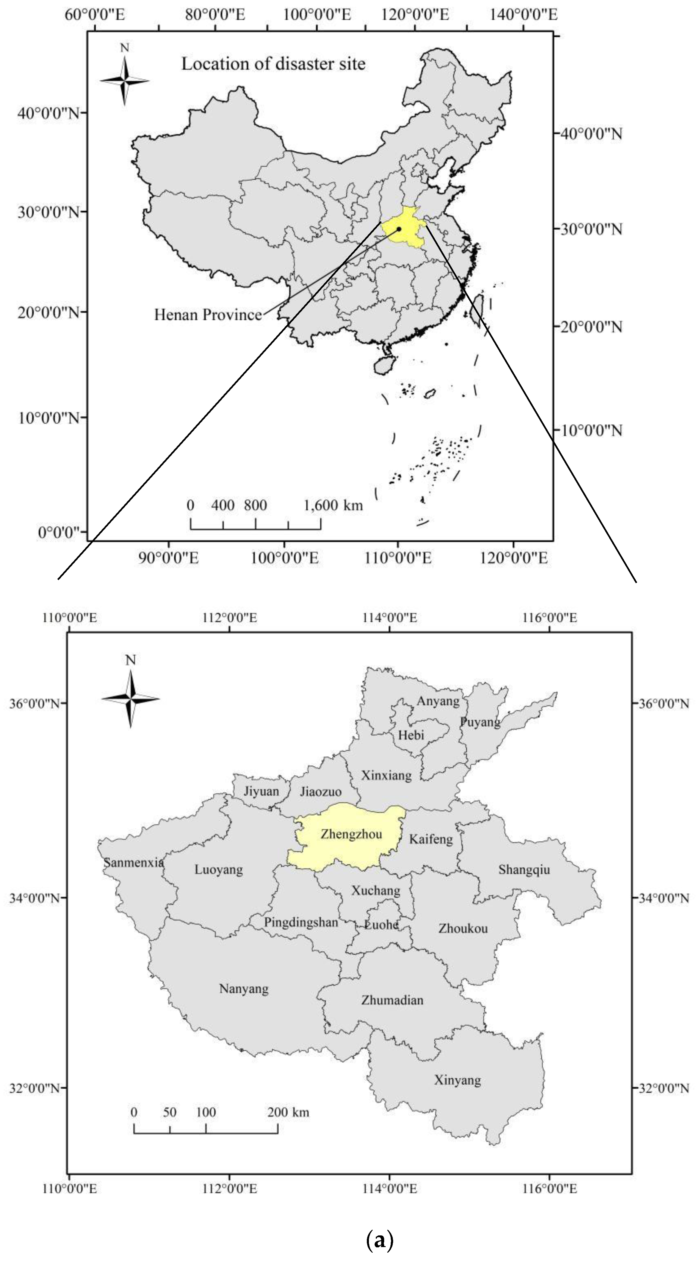
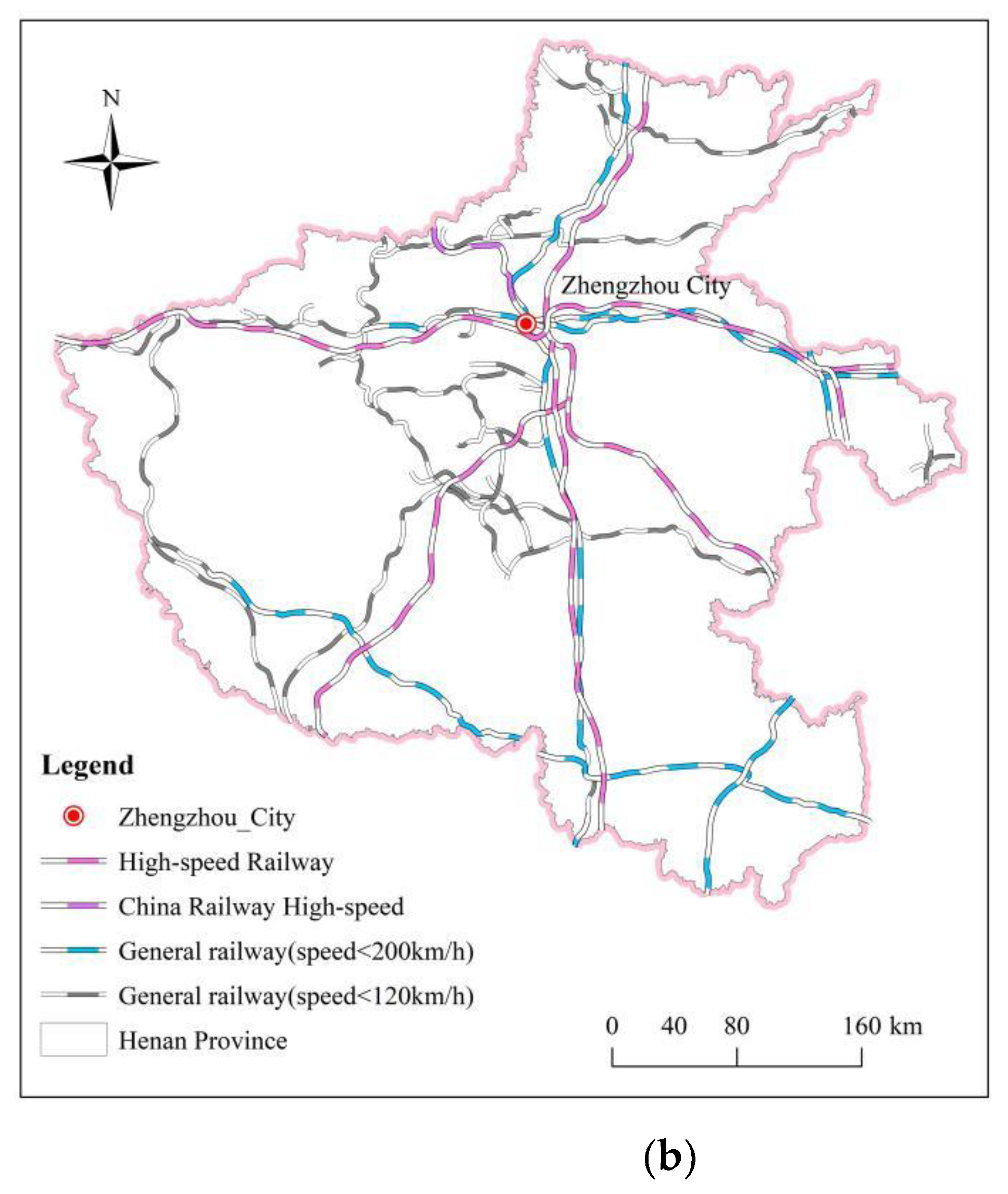
Figure 4.
Zhengzhou subway route map.
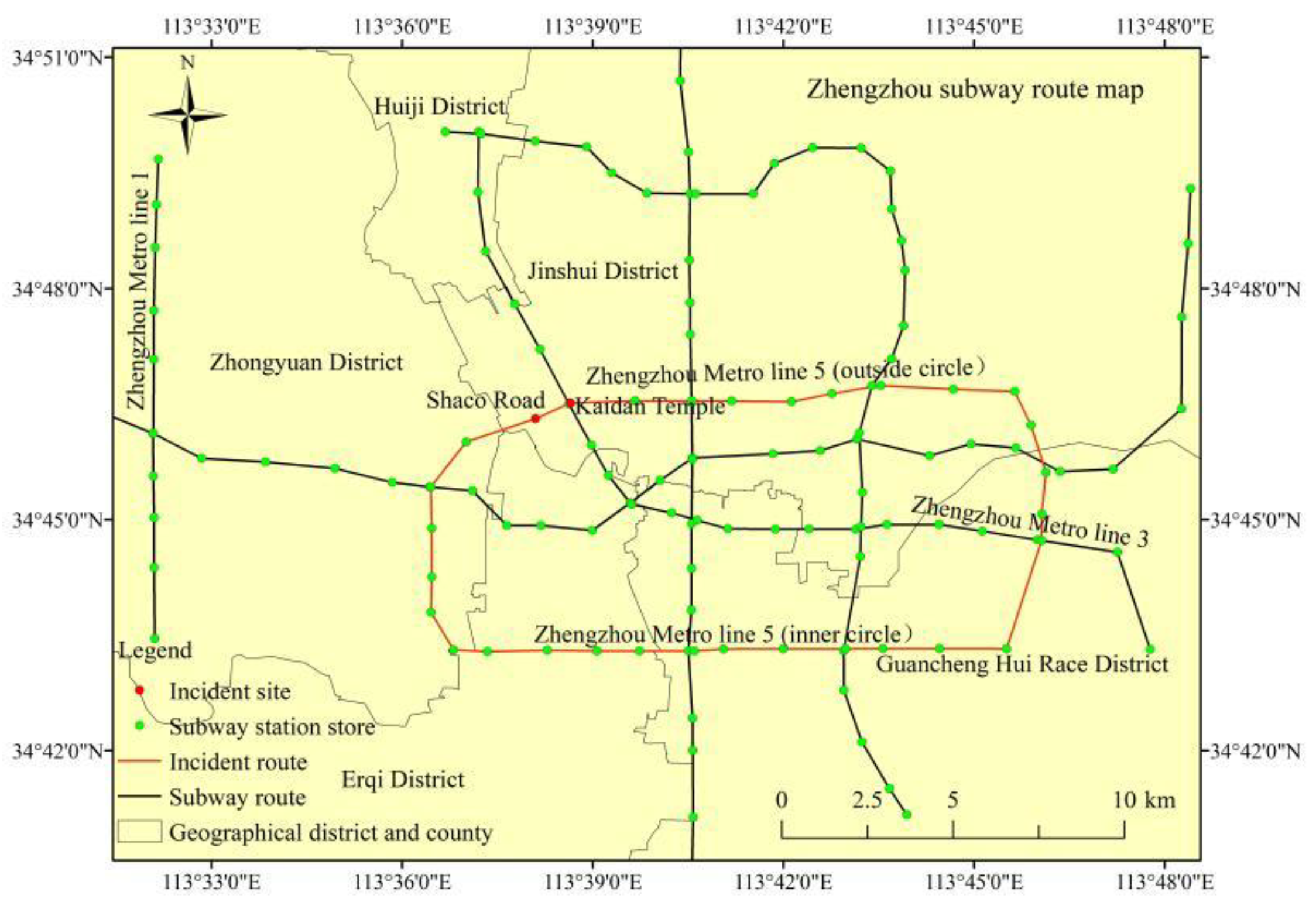
Figure 5.
Zhengzhou suffered from historical extreme rainfall: (a) Zhengzhou meteorological workers guarantee the normal operation of the automatic station [17]; (b) strength map of precipitation for the whole day on 20 July (modified from the Chinese Central Meteorological Station, 2021).
Figure 5.
Zhengzhou suffered from historical extreme rainfall: (a) Zhengzhou meteorological workers guarantee the normal operation of the automatic station [17]; (b) strength map of precipitation for the whole day on 20 July (modified from the Chinese Central Meteorological Station, 2021).
Figure 6.
Firefighters rescue the trapped people: (a) using safety ropes to guide trapped victims [21]; (b) rescuing the passengers from the main subway line [22].

Figure 7.
A broken line chart of the passenger flow on Metro Line 5 in the week before the accident: decreasing from 17 to 18 July 2021 due to holidays. However, a passenger flow of 474,500 people was maintained under heavy rain on weekdays. (Recreated from Zhengzhou Metro, https://weibo.com/u/1993390131 (accessed on 6 May 2022)).

Figure 8.
Flowchart of a flooding management system.


Table 1.
Information on the daily rainfall breaking the record in Henan Province (daily rainfall from 08:00 to 08:00 the next day). (Data source: Chinese Central Meteorological Station, https://weibo.com/ttarticle/x/m/show/id/2309404662497868382366?_wb_client_=1 (accessed on 6 May 2022)).
Table 1.
Information on the daily rainfall breaking the record in Henan Province (daily rainfall from 08:00 to 08:00 the next day). (Data source: Chinese Central Meteorological Station, https://weibo.com/ttarticle/x/m/show/id/2309404662497868382366?_wb_client_=1 (accessed on 6 May 2022)).
| Site Name | Date | Daily Precipitation (mm) |
|---|---|---|
| Zhengzhou | 20 July 2021 | 624 |
| Huixian | 21 July 2021 | 447 |
| Anyang | 21 July 2021 | 436 |
| Qixian | 21 July 2021 | 436 |
| Hebi | 21 July 2021 | 430 |
| Songshan | 19 July 2021 | 365 |
| Xinmin | 20 July 2021 | 358 |
| Tangyin | 21 July 2021 | 345 |
| Weihui | 21 July 2021 | 326 |
| Xingyang | 20 July 2021 | 317 |
| Fugou | 20 July 2021 | 302 |
| Kaifeng | 20 July 2021 | 278 |
| Huojia | 21 July 2021 | 253 |
| Weishi | 20 July 2021 | 244 |
| Xinzheng | 20 July 2021 | 226 |
| Jiaozuo | 20 July 2021 | 201 |
| Yanshi | 20 July 2021 | 198 |
| Dengfeng | 19 July 2021 | 193 |
| Boai | 21 July 2021 | 177 |
| Jiyuan | 20 July 2021 | 139 |
Publisher’s Note: MDPI stays neutral with regard to jurisdictional claims in published maps and institutional affiliations. |
© 2022 by the authors. Licensee MDPI, Basel, Switzerland. This article is an open access article distributed under the terms and conditions of the Creative Commons Attribution (CC BY) license (https://creativecommons.org/licenses/by/4.0/).
Share and Cite
MDPI and ACS Style
Yang, H.; Zhao, L.; Chen, J. Metro System Inundation in Zhengzhou, Henan Province, China. Sustainability 2022, 14, 9292. https://doi.org/10.3390/su14159292
AMA Style
Yang H, Zhao L, Chen J. Metro System Inundation in Zhengzhou, Henan Province, China. Sustainability. 2022; 14(15):9292. https://doi.org/10.3390/su14159292
Chicago/Turabian StyleYang, Hao, Linshuang Zhao, and Jun Chen. 2022. "Metro System Inundation in Zhengzhou, Henan Province, China" Sustainability 14, no. 15: 9292. https://doi.org/10.3390/su14159292
Note that from the first issue of 2016, this journal uses article numbers instead of page numbers. See further details here.