AdRem: An Integrated Approach for Adaptive Remediation
by
 , , ,
, , ,
Valerio Palma
1,2 ,
,
Federico Accorsi
2,3,
Alessandro Casasso
3 ,
,
Carlo Bianco
3 ,
,
Sarah Cutrì
2,3,
Matteo Robiglio
1,2 and
Tiziana Tosco
2,3,* 1
Department of Architecture and Design (DAD), Politecnico di Torino, Viale Pier Andrea Mattioli 39, 10125 Torino, Italy
2
FULL—The Future Urban Legacy Lab, Politecnico di Torino, Via Agostino da Montefeltro 2, 10134 Torino, Italy
3
Department of Environment, Land and Infrastructure Engineering (DIATI), Politecnico di Torino, Corso Duca degli Abruzzi 24, 10129 Torino, Italy
*
Author to whom correspondence should be addressed.
Sustainability 2021, 13(1), 28; https://doi.org/10.3390/su13010028
Submission received: 17 November 2020
/
Revised: 9 December 2020
/
Accepted: 17 December 2020
/
Published: 22 December 2020
(This article belongs to the Special Issue Green and Sustainable Groundwater and Soil Remediation Approaches)
Abstract
:Abandoned industrial sites are generally characterized by soil and subsoil contamination. The paradigm currently employed for their remediation is “tabula rasa”, i.e., remediation of the entire site before its repurpose. However, this method is not economically, socially, or technologically sustainable: it delays the reuse of large areas, often well-connected to infrastructures, whose reuse may prevent further soil consumption. A possible solution to this problem is the application of adaptive reuse principles. This study, conducted at FULL (Future Urban Legacy Lab) in Politecnico di Torino, presents an interdisciplinary approach to spatialize, visualize, and manage interactions between reclamation and urban design for the transformation of contaminated urban areas. The core is based on a decision support parametric toolkit, named AdRem, developed to compare available remediation techniques and schematic urban design solutions. AdRem uses a 3D modeling interface and VPL scripting. Required input data are a geometric description of the site, data on the contamination status, viable remediation techniques, and associated features, and schematic urban design recommendations. A filtering process selects the techniques compatible with the site use foreseen. The output is an optimized remediation and reuse plan that can support an interdisciplinary discussion on possible site regeneration options.
1. Introduction
Following the real estate crisis of 2007–2008 and the consequent reduction of the demand for buildings, abandoned industrial sites have increasingly become an environmental, social, and financial burden [1]. In countries and regions with a strong history of industrialization and deindustrialization, an increasing number of brownfield remediation interventions is taking place in urban contexts, with the related challenges posed by the combination of reclamation processes and building reuse and adaptation [2,3,4]. Compared to the reclamation and recovery of sites located in active industrial areas outside of cities, brownfield regeneration in an urban context poses additional constraints (e.g., restrictions on site morphology variations—even temporary ones—and on area use), and is connected to the landscape characterization and overall perception of the place [2,3]. Nevertheless, brownfields patently represent a potential resource, since they are often embedded in the urban fabric, well-connected to the infrastructure system, and equipped with a dense network of sub-services [5,6].
In addition to environmental restoration and human health protection, recovering contaminated urban brownfields can offer relevant advantages, including exploiting the existing infrastructures, preserving greenfields, producing positive social and economic effects for nearby communities—such as higher property values and reduced crime rate—and contributing to environmental, economic, and societal sustainability [1,2,3]. In these situations, urban regeneration and brownfield reuse actions are potentially intertwined processes, even though they are rarely planned and designed as such [7].
The complex interactions among architectural, societal, environmental, and economic factors that all contribute to the success of brownfield recovery in urban areas are not always taken into account in an integrated way. Noticeably, decision support tools (often GIS-based) have been developed to help the screening at regional and urban level of the potentially recoverable sites. Such tools provide support to prioritize among potentially recoverable sites, taking into account the abovementioned context, and successful applications of such approaches are reported in the literature [8,9,10,11]. However, when it comes to the individual brownfield (for example, once the site to be recovered has been identified), an integrated approach for the remediation and reuse design is much less common. The usual approach is still disjointed, with limited cross-disciplinary interactions among practitioners; in most cases, a generic destination for the site is defined (e.g., residential, commercial, industrial, etc.), and the site is first remediated before a clear reuse plan is defined, obtaining an entirely reclaimed area (tabula rasa). As a second step, the new use of the site is planned and designed ex novo. This can be the most efficient approach for sites without any peculiar landscape, historical, or architectural value. However, it may become highly inefficient in an urban context, in particular for sites associated with the industrial legacy, since they are deeply embedded in the surrounding areas, in the history, and in the culture of the city. The overall design process is therefore fragmented, resulting in a loss of shared knowledge and potential solutions, as already highlighted by Lange and McNeil [12]. From an economical point of view, the limited resources available for the remediation of contaminated sites call for new solutions that integrate brownfield remediation and industrial legacy reuse to meet the new socioeconomic needs [13].
In this framework, the concept of adaptive remediation was developed as an evolution of the well-established adaptive reuse approach [14]. The term adaptive reuse describes an architectural and urban design strategy that aims at transforming a site, keeping intervention measures at a minimum, and matching existing elements, new functions, and needs by optimizing transformations and enhancing the as-is status [4,15]. This approach can be applied to different (but not necessarily old) buildings, areas, or infrastructures that have lost their original function and can be retrofitted for new uses. Even though the formalization of the adaptive reuse concept in architecture dates back to the 1970s [16], the reuse of old industrial buildings started earlier, soon after World War II. Andy Warhol’s studio, labelled “The Factory” and established in the early 1960s in a former fire station, is a good example of reusing an old industrial building, taking advantage of low prices and highly flexible spaces [17].
Despite its clear efficacy in merely architectural terms, classical adaptive reuse is inefficient when applied to contaminated sites, since it focuses on the built elements only, and does not consider site remediation as a prerequisite [18]. A step forward is adaptive remediation: the principles of the adaptive reuse approach (minimal intervention, timing flexibility, use update) are extended to remediation activities. Remediation alternatives are considered not only in terms of technical and economic constraints (technical feasibility, safety requirements, capability to meet remediation goals, and budgetary constraints), but also in connection with the existing buildings and their historical and architectural legacies worth preserving, the expected reuses, and the planned functions of that area. Ideally, the process also considers the surrounding urban context and its connection with the site being recovered, and, when possible, the (tunable) timing of remediation and recovery (Figure 1). Moreover, technological interactions of remediation technologies and building reuse can also be planned, e.g., reducing the environmental footprint of Pump & Treat plants for the hydraulic confinement of contaminated groundwater by coupling this system with heat pumps for building heating/cooling [19].
Many projects under the category of adaptive reuse have dealt with polluted sites and found solutions bridging remediation and architectural, urban, and landscape design [20]. Gas Works Park in Seattle (Washington, USA), designed by Richard Haag Associates and built between 1971 and 1976, is considered one of the first examples of adaptive transformation of a post-industrial landscape [21,22,23]. The Landschafts Park Duisburg-Nord in Germany is another example of the conversion of a former (contaminated) industrial area into a park [23,24,25]. The Parco Dora in Turin (Italy), opened in 2011, is a post-industrial park designed by Peter Latz and Partners [23,26], and represents a successful case of integrated industrial site reclamation, returning public infrastructure to the densely built-up city.
The adaptive remediation approach integrates the concepts of standard remediation interventions and adaptive reuse for successful recovery of the site. The adaptive remediation approach is consistent with adaptive reuse regarding the progressive implementation of the solutions, both in time and space. The term adaptive also describes the relationship between remediation alternatives and architectural or landscape design during the planning phases. For example, the impermeabilization of the top soil can serve both as a pavement for roads and parking areas and as a permanent safety measure against contaminant migration from the vadose zone through infiltration, the excavation of contaminated soil can be exploited for foundations and underground constructions, and on-site reclaimed soil (e.g., via land farming or soil washing) can be used as inert or to construct an artificial hill. Clearly, it is possible to make these design choices—which all lead to a reduction of construction costs and overall impacts—only if remediation and urban transformation are considered as a whole, and not as separate processes.
Indeed, integrating all of these aspects requires an inter-disciplinary knowledge of all of the practitioners involved and the support of structured workflows and quantitative indicators to analyze, compare, and prioritize remediation and architectural alternatives. The development of an integrated remediation and reuse plan can be carried out using a semi-qualitative approach in the case of relatively small sites, where few clear alternatives are available for both remediation and building reuse. A typical example is the choice between in-situ and ex-situ remediation technologies. As a general rule, in-situ treatments are preferred due to lower overall impact, but, should a large excavation be needed for other purposes (e.g., a new building), ex-situ sediment treatment may become preferable. Conversely, when complex sites are considered, such a choice is not straightforward, and the comparison and prioritization of design alternatives require quantitative tools, which are currently not available.
In the last few years, great efforts have been devoted to develop approaches and methodologies to integrate the classical remediation technology design in a wider context; notably, guidelines and tools have been proposed, for example, to incorporate the sustainability principles in the remediation of a contaminated site, and using risk assessment and risk management as drivers in the remediation design and implementation [27,28]. However, such guidelines and standardized tools consider the anticipated future use of the site in generic terms (e.g., risk-based cleanup standards are defined based on residential, industrial, or commercial planned use or similar classifications, depending on the local legislation), without taking into account the specific needs of the site (e.g., the need for a parking area to a given extent, residential buildings of a given volume, or a green area, etc.). Conversely, a few tools have been developed so far to combine remediation and urban reuse design, allowing a proficient integration of the two processes on the specific site and for specific pre-determined needs. Among them, the Optirisk® tool represented a valuable experience of integrated planning of brownfield reuse; the tool is no longer available to the public, but its application in several case studies resulted in a series of recommendations and adaptive remediation concepts [29].
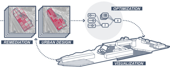
This article presents the AdRem (adaptive remediation) tool, which was developed to integrate the different disciplines (in particular, environmental engineering and architecture) involved in the design of brownfield reuse, specifically the one applied to urban contexts. AdRem comes into play in a (relatively) advanced stage of the site recovery design, when urban reuse alternatives have been identified and a risk assessment has (at least preliminarily) identified remediation targets, but interventions have not been designed yet. More specifically, AdRem is intended to help the involved technical players (in particular, at this stage, environmental engineers and architects) converge to an optimal, integrated remediation and reuse design, which is expected to proceed in parallel, and not in series. As a part of the AdRem approach, a prototype decision support toolkit was developed to quantitatively screen and prioritize the architectural design and remediation alternatives. The toolkit, developed using the visual programming language Grasshopper (GH), takes part in the inter-disciplinary design phase by processing a pre-set of remediation and architectural alternatives, as identified by the designers, for homogeneous sub areas. Remediation alternatives are compared with architectural needs and vice-versa, leading to a screening of remediation/reuse projects, which are then prioritized based on costs and timing. The outputs of the toolkit provide the information to implement the last AdRem design step, when environmental and architectural designers identify the optimal integrated project, eventually using the toolkit in a recursive manner. The application of the AdRem approach to a test case is presented in Section 3.
2. Methods
In this paragraph, an overview of the AdRem general structure is provided (Section 2.1), followed by a detailed description of the decision support tool (the AdRem toolkit, Section 2.2) and its implementation (Section 2.3).
2.1. The AdRem Approach
The AdRem approach is based on an integrated, quantitative screening and ranking of remediation and architectural design alternatives for optimized reuse of a brownfield. It is intended to be applied when the site general destination is already defined, environmental characterization has been performed, and general constraints for both urban re-development (i.e., expected future uses of the area) and environmental restoration (i.e., areas and environmental matrices to be remediated) have been already identified.
AdRem is structured in the following steps:
- Step 1: a pre-design phase, in which architects and environmental engineers define the preliminary options and constraints associated with the respective projects and identify homogenous sub-areas within the brownfield (e.g., the set of remediation technologies technically applicable to each sub-area of the contaminated site is defined, and buildings or part of buildings that cannot be demolished are identified).
- Step 2: a model-assisted phase, representing the core of the AdRem approach. Here, the GH toolkit is used to prioritize design alternatives; it includes (Figure 2):
- ○
- Step 2A: a database population phase to set the input data for the target site. The information on the contamination, the viable remediation technologies (with associated technical constraints, resulting site transformations, and a preliminary estimate of costs), the requirements, options, and constraints of the architectural design are identified, and associated to sub-areas;
- ○
- Step 2B: a screening phase, where a screening is performed on viable remediation techniques to exclude all those not coping with reuse constraints (e.g., dig and dump of contaminated soil is excluded in areas of existing buildings that must be preserved), and technical constraints of remediation techniques are taken into account for reuse options (e.g., sub-areas where all suitable remediation technologies are expected to require several years are excluded for immediate building construction);
- ○
- Step 2C: an optimization phase, where a parametric optimization of the remaining remediation technologies and architectural design options is run. Alternatives are ranked based on reuse priorities and remediation costs;
- ○
- Step 2D: a visualization phase, where a dynamic graphical output of the envisioned morphological transformation of the site is produced to support further discussion of the design alternatives.
- Step 3: An interdisciplinary evaluation and correction phase, where options and their associated ranking are evaluated by architects and engineers and discarded or accepted. To this aim, the toolkit is embedded in a recursive methodological framework, allowing for a continuous exchange of information between disciplines and eventually performing a cyclic application of the toolkit.
2.2. Structure of the AdRem Toolkit
The AdRem toolkit represents the core of the overall AdRem approach, and is composed of four different steps, as introduced above. In this paragraph, a deeper insight of its structure is presented (Figure 2).
Step 2A of the AdRem toolkit is the database population phase. It consists of the collection of data and preliminary design alternatives for the remediation technologies (environmental design) and for the brownfield future use (urban/architectural design) obtained in Step 1 of the AdRem approach. The information is organized into two main groups (Table 1), namely: (1) remediation input information, that is, georeferenced information on contaminated areas and viable remediation technologies, and (2) urban planning input information, that is, georeferenced information on existing buildings and infrastructures and on hypothesized reuse options. The surface of the target site is organized in non-overlapping sub-zones, over which the data of the two groups are homogeneously defined.
The remediation input information is the result of a prior standard procedure of the preliminary design for site remediation, which is a prerequisite for the AdRem toolkit application: the site is fully characterized in terms of soil and groundwater properties (soil morphology, geology, and hydrogeology), contamination (contaminant species, spatial distribution, and concentrations), and definition of a conceptual model (identification of source(s) of contamination, migration pathways, receptors). Via a human health risk assessment, the contaminants of concern and the associated remediation targets are identified. Finally, homogeneous sub-zones are defined, and a set of applicable remediation technologies suitable to reach the remediation targets is identified and associated to each sub-zone. The dataset of the remediation techniques is organized in tabular form.
The urban planning input information is in turn the result of a prior preliminary design of the site reuse. The input to the AdRem toolkit includes the volumetric extent of existing buildings, site orography, and a set of project requirements, namely required construction times, planned uses, and conservation of pre-existing buildings. Urban design prescriptions can be defined as mandatory (when they cannot be neglected/modified) or preferential (when a project requirement is desired or preferred, but it is not compulsory). In the second case, they are expressed as a priority of the transformation (high, low) and general designated use. Similarly to remediation inputs, in this case homogeneous sub-zones are also identified (e.g., a sub-zone corresponds to a planned parking area, a new building, a garden, etc.). As a last phase of Step 2A, new sub-areas are defined from the intersection of remediation and architectural/urban design inputs, which are therefore homogenous for both sets of attributes.
Following the input information collection and classification, the second step of the AdRem procedure is the screening phase (Step 2B). Starting from the initial set of available remediation techniques, the tool performs a screening of the remediation alternatives against the mandatory requirements given by the urban design plan, and, for each sub-zone, excludes the technologies that are not compatible with those constraints. More in detail, the tool checks for the compatibility between the morphological alterations of the site produced by the alternative remediation methods and the designated use of the areas, in particular with the planned conservation of pre-existing buildings (if any). Moreover, the priority of the transformation is compared with the application timing of the techniques, thus discarding those technologies that envision a duration longer than the time planned to fully recover the availability of the area in the urban plan. As a result, Step 2B defines a subset of the initial remediation technologies.
In the optimization phase (Step 2C), the tool ranks the remaining remediation technologies based on the remediation cost. The estimated cost per each remediation alternative in each sub-area is calculated based on the unit costs defined in Step 2A. When several architectural/urban design alternatives characterized by different reuse priorities are available, the check against remediation timing may be implemented here in Step 2C and not in Step 2B. In other words, if the reuse priority is not unique to a sub-area and alternative architectural design options are available, the timing can be used as an additional ranking criterion in Step 2C, rather than an exclusion check in Step 2B.
The final output of the AdRem toolkit (Step 2D) is generated by editing the geometric model. The tool applies the morphological transformations produced by specific remediation methods, e.g., excavation lowers the surface and capping rises it. Finally, the transformation scenarios produced by the AdRem toolkit are used as a support to the discussion of each proposed solution (Step 3 of the AdRem overall approach). This discussion can lead to a modification of design prescriptions and constraints on recovery timing, investments, and land uses. For instance, it is possible to change the designated use of a sub-zone, finding a more compatible location suggested by the algorithm. Morphological transformations of the area related to remediation methods can also potentially lead to previously unthought-of urban design proposals. The revised plan can again be used as an input for the automated part of the process in order to check its compatibility with contamination and further be optimized. It should be noted that a change in the designated land use may require a modification of the risk analysis procedure, because different uses involve different definitions of environmental risk.
2.3. Implementation of the AdRem Toolkit
The AdRem toolkit was developed as a script for the 3D modeling software Rhinoceros (RH), using its internal visual programming language (VPL) Grasshopper (GH) (www.rhino3d.com). GH allows the building and editing of 3D models in RH projects using dynamic parametric tools and coding. As with other VPL software, GH features a graphical interface, which is organized in nodes and arrows, i.e., functions connected through output and input relations. In order to interact with the GH algorithm, a set of input areas must be set up in the modeling environment as RH surface elements. Vector files can also be imported through different file formats (i.e., DXF, OBJ, PLY, ESRI shape-files), allowing data exchange with other modeling software or geo-information tools. Input data are collected in CSV tables, each row corresponding to an input surface from RH. This information can be added to the GH script through the panel tool (as an array of data in text format) or using the LunchBox plug-in (as an MS Excel file) [30]. It is possible to account for orography by properly modeling the input surface in the RH environment and in pre-existing buildings. Each RH surface grants read/write access to the GH tool.
For the implementation of the AdRem toolkit, both pre-built nodes and custom functions written in Python language were employed to build the GH script. RH was used to represent the site. The developed GH script filters the available remediation techniques and architectural design options based on feasibility constraints and design proposals. Alternative planning prescriptions can also be used, dynamically switching the input data to rapidly compare different results. The final proposal ranking is computed as a parametric optimization considering reuse priorities and cost minimization, choosing among the techniques still available.
Finally, the script produces a visual output to be used as a design-supporting scenario. GH receives the surfaces defined into RH as input, then it modifies them, applying the transformations connected to the chosen remediation technique (i.e., changes of ground surface elevation due to soil displacements). The resulting 3D model can be seen as a dynamic preview in RH and then saved as a new model. The GH script shows in a panel the chosen technique for each sub-zone, while the modified 3D model is displayed in the RH interface. The VPL script allows user interaction for a real-time adaptation of the results, i.e., modifying the input data to choose alternative planning proposals. Thanks to the rapid and automatized preview of morphology changes induced by different remediation scenarios, the AdRem toolkit supports the recursive process of searching for an optimal combined solution of remediation and urban transformation.
3. Case Study
As an example of the implementation of the AdRem approach, a case study from the literature was selected, and the AdRem toolkit was applied to it.
3.1. Site Description
The former industrial area of Nitrastur (Nitratos Asturianos) is located in La Felguera (Langreo, Asturias, Spain), with a total area of 20 hectares. It was established in 1923 as a chemical factory, mainly for fertilizer production (ammonium nitrate and sulfate), and remained active until 1997. During the twentieth century, the factory was partly re-converted and the structures were modified at different times; several buildings were demolished, but some were maintained and are today considered as one of the best examples of modernism in Asturias. In 2019, the Nitrastur site was included in the Red List of Heritage (Lista Roja del Patrimonio) compiled by the association Hispania Nostra, who listed the sites considered as at risk, but worth being preserved given their relevance from a historical and architectural point of view.
In the past, a widespread soil and groundwater contamination was detected all over the site, with a total extent of approximately 70,000 m2. The main contaminants identified were pyrite ashes, metallurgical slags, and coal waste extensively used as filling materials, with an average estimated thickness of 3.5 m. A detailed description of the site hydrogeology and contamination is reported in previous studies [31,32,33,34]. The key information is summarized here.
The natural subsoil consists of heterogeneous alluvial deposits, with a sandstone bottom layer at 6–9 m b.g.l. The quaternary deposits host an unconfined aquifer, with an average depth to water table of 2–3 m, which locally includes the pyrite ashes in the saturated zone. Contaminants (mainly heavy metals) have been released by lisciviation of the filling materials via rain infiltration or direct contact with groundwater, thus contaminating subsoil and groundwater [33,35]. Eight heavy metals were identified as contaminants of concern for risk assessment [31]; among them, arsenic (As), mercury (Hg), and lead (Pb) were the most relevant ones. The site is currently abandoned, and plans for its recovery are continuing. Partial reclamation activities are under evaluation or in progress, and pilot applications have been recently performed for soil washing [35], phytoremediation [32] for the soil matrix, and nano-remediation for groundwater [36,37,38].
The redevelopment of the area through a project of adaptive reuse and remediation would support an integrated recovery of the site and allow the preservation of buildings subject to architectural constraints. In this work, the remediation focus was on the soil matrix only, while groundwater is not considered.
3.2. Application of the AdRem Approach
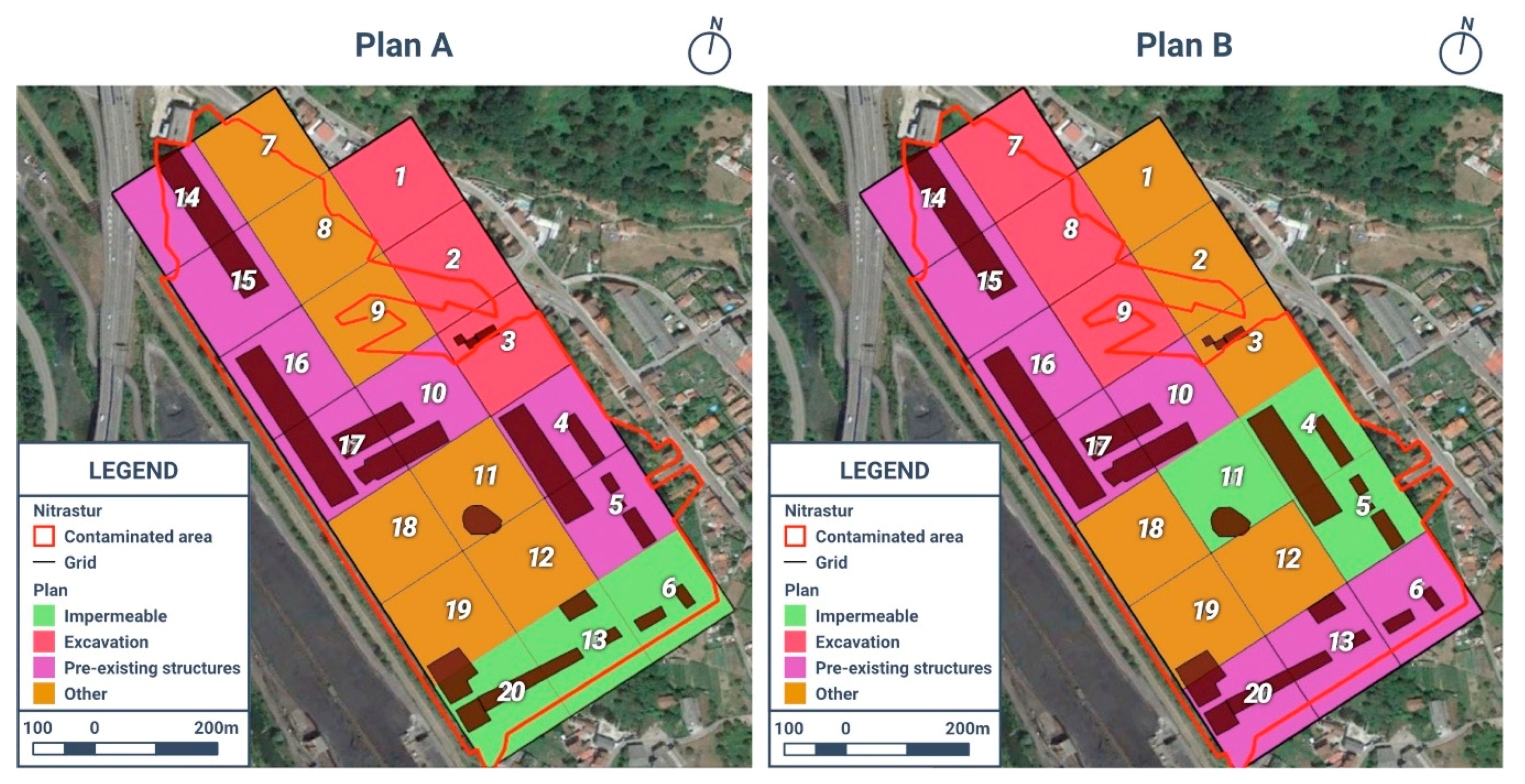
Based on the characterization information and constraints gathered from the abovementioned literature, Step 2A (database population) was implemented. The sub-zones defined by Wcisło et al. [31] were adopted here for the remediation input information: the site was divided into 20 sub-zones, with a regular mesh grid of 100 m × 100 m. For each of them, the level of contamination and the associated human health risk is known [31]. For this application, the 100 × 100 m parcels are assumed to be homogenous in terms of soil characteristics, contamination, and planned future use, since no information is available at a smaller scale. The 20 sub-zones, identified with codes 01 to 20, were loaded on Rhinoceros. Based on the site characterization (i.e., contaminant species, level of contamination, and remediation target), a list of remediation techniques technically applicable on each sub-zone was compiled, also identifying areas that do not require remediation (Table S1 in Supporting Information). To each sub-zone, the volume of soil to be treated was also computed, excluding uncontaminated portions of the sub-zones and buildings that are not expected to be demolished (Table S1). An average depth of treatment of 1 m was assumed. For each remediation technology, the produced morphological transformation, the compatibility with expected land use(s), timing, and estimated unitary costs were defined (Table S2).
As for the urban planning input information, the as-is morphology of the site was implemented in the 3D model in Rhinoceros; the information on the pre-existing buildings in each parcel was also included. Two different architectural restoration projects of the site (Plan A and Plan B, Figure 3) were considered. The planned uses and priorities associated to each sub-area are reported in Table S3. The definition of the two architectural projects took into account the presence of existing buildings with a heritage value (located in sub-areas 11 and 15–18) that cannot be demolished. Other existing buildings (in sub-areas 04–06, 13, and 20) could be potentially reused, but not all of them are necessary. Therefore, Plan A envisioned the preservation of buildings in sub-areas 04 and 05, while in Plan B, those in 06, 13, and 20 were selected. Alternative options for three sub-areas dedicated to underground parking (S01–03 in Plan A, 07–09 in Plan B) and three sub-areas dedicated to paved parking (06, 13, and 20 in Plan A, 04, 05, and 11 in Plan B) were also considered. The remaining areas were left open to other, still unidentified uses.
Following the database population phase (Step 2A), the screening phase (Step 2B) combined the different types of input information (Tables S1–S3 in Supporting Information) to select a sub-set of remediation alternatives for each sub-area. As a result of the screening phase (Step 2B), for each restoration project (A and B), the AdRem toolkit provided the final list of remediation alternatives for each sub-area, with results that were compatible with all architectural constraints (Table S4 in Supporting Information). As an example, Plan A envisioned the realization of underground structures in the sub-area 01 within a short time frame; this makes soil flushing inapplicable, due to its long remediation timing. Capping and in situ stabilization are also excluded in sub-area 01, since they are not compatible with the foreseen excavation activities. On the other hand, both soil washing and direct disposal of the excavated soil allow exploitation of the excavation of the soil (obviously needed to realize underground structures) for remediation purposes. Conversely, for Plan B, where no specific future use was planned, in situ stabilization and capping were excluded, since they prevent any future use of the area.
In the optimization phase (Step 2C), for sub-areas where more than one technology was selected, the least expensive was adopted. Consequently, the final output of the AdRem toolkit was a list associating to each sub-area the least expensive remediation technique, which reflected all of the requests introduced in the previous steps (Table 2 and Table 3). In both alternative scenarios, all six remediation technologies originally considered were selected in at least one sub-area. Under the Plan A scenario, soil flushing and in situ stabilization were the most frequently selected technologies; under Plan B, soil flushing was the preferred one, thanks to a more delayed reuse plan. For an easier comparison of the impact of the individual technologies Table S5 reports for Plan A and B a summary of treated volumes, costs, and their relative importance for each remediation technology. The total cost of remediation under the two alternative scenarios was significantly different, with costs for Plan B being more than four million euros lower than Plan A. It can be observed that, in terms of treated volumes, the predominant technologies were soil flushing, in situ stabilization, and soil washing in both scenarios. Soil flushing was the most impacting technology for Plan B; the different unit cost of the three technologies, with soil flushing the least costly, resulted in the overall lower cost of the remediation under Plan B.
4. Discussion
The implementation of an adaptive remediation approach that explicitly couples the selection of remediation technologies and the expected use of the individual parcels helps in the optimization of the overall process, and in reducing remediation costs. From Table 2 and Table 3, it is evident that, regardless the specific scenario, taking into account the future use has allowed consideration of the long-term remediation technologies (among all, phytoremediation), characterized by a lower implementation cost and lower overall impact on the site and the ecosystem, as well as technologies that impose a limitation on the future use of the area (e.g., capping, which excludes future excavation). Noticeably, phytoremediation and capping are the technologies with the lowest unitary cost among those considered here (see Table S2 in Supporting Information). If the tabula rasa approach had been applied to this site, these remediation technologies would have been excluded to make a clean site available in a short time frame (no phytoremediation), and ideally with no limitations on future morphological transformations (no capping), thus resulting in a significantly higher cost of site reclamation.
The ranking criterion (i.e., lowest cost) for remediation alternatives remaining from Step 2B obviously and significantly affects the final result: in this illustrative test case, for sub-areas where more than one remediation technology was compatible with the urban constraints (that is, when, at the end of Step 2B, more than one technology remains available for a sub-area), the selection is simply based on the expected remediation cost. However, different optimization strategies can obviously be applied, depending on the overall purpose of the reuse plan, the local costs of the remediation, and more general priorities. For example, in the framework of a sustainable remediation approach, the remediation with a faster implementation or remediation technologies with lower overall impact could be preferred over the option with lower costs. Likewise, other optimization criteria, which are expected to be site-specific, can potentially be considered. In this perspective, the AdRem toolkit structure is not rigid and, in view of the implementation of optimization criteria other than the remediation cost, additional attributes can be included in the input table. As an example, remediation sustainability can be included in the optimization process by associating to each remediation technology a sustainability index or indicator defined following the approaches presented by Holland et al. [39] and Hou and Al-Tabbaa [40]. To include social impacts in the ranking process of AdRem future releases, the indicator categories identified by SURF-UK are appropriate candidates [41]. As for soil ecosystem services, a number of quantitative and qualitative indicators have been proposed in the last years, and including pedologists in the group of professionals involved in the evaluation process would be necessary to guarantee the selection of the most appropriate ones [42]. On the other hand, the input associated with the urban planning can be expanded and adapted to different needs, for example, to provide richer planning information and to include site logistics and economies of scale as additional crucial economic factors.
The objective of the AdRem approach is to establish an interdisciplinary dialogue between the professionals involved in the recovery of abandoned industrial sites, namely those assessing site characterization and remediation (environmental engineers, geologists, pedologists, etc.) and those addressing the adaptation of spaces in the post-industrial city (architects and urban designers). This interaction allows the overcoming of the most common but partly inefficient tabula rasa approach to brownfield recovery, based on separated and sequential remediation and reuse planning. Conversely, AdRem proposes an adaptive and incremental approach, integrating remediation and reuse planning in a recursive design, and thus leads to optimal solutions in terms of timing, costs, and—in perspective—social, environmental, and financial sustainability. Remediation costs are the only costs that come directly into play in the current release of the AdRem tool; social and economic aspects are expected to be covered in the early stages of reuse planning when defining the set or reuse alternatives to be screened by AdRem. However, a future development of AdRem may also explicitly include social and economic aspects in the recursive optimization process, as well as other indicators (e.g., for ecosystem services associated with soil recovery).
5. Conclusions
The main results achieved at this stage of development of the AdRem approach include:
- the definition of a cooperation strategy between the practitioners involved in brownfield regeneration, including a sequence of operations to be performed synergistically and a set of common goals;
- the identification of the main data and analysis levels needed by the different professionals;
- the identification of the main criteria for spatializing site information and outputs;
- the development of software procedures to produce graphical models that show morphological characteristics of the site and a preview of the transformation determined by different remediation techniques;
- the development of software procedures to support effective remediation processes based on cost optimization.
The formulation of the decision support parametric tool herein presented was produced for planning, screening, and optimizing the regeneration of a large contaminated site. Its implementation procedure was demonstrated by applying it to a case study from the literature, with the purpose to identify among two equally suitable site reuse alternatives the one requiring the less expensive site remediation. To this aim, the AdRem approach application seems to be appropriate when considering large, complex sites, where the presence of several buildings, heterogeneous soils, and contamination are likely to occur. However, an alternative AdRem application can be envisioned at a regional scale, even for simpler sites, as a planning support tool for the prioritization of different brownfields’ remediation.
This work is a first step towards an interoperable tool to spatialize environmental remediation and architectural design alternatives, constraints, and desiderata in order to develop integrated parametric design solutions. However, it is worth underlining that the proposed framework does not delegate the decision process to automation. Initial inputs (the urban project), results evaluation (computed scenarios), and a sequence of iterative phases require professionals’ expertise, responsibility, and collaborative attitude in order to make the design process itself adaptive. The AdRem approach is intended to be a support and not a substitute to the professional work of operators from different fields of expertise involved in a brownfield recovery.
Supplementary Materials
The following are available online at https://www.mdpi.com/2071-1050/13/1/28/s1. Figure S1: General site map. Table S1: Step 2A of the AdRem toolkit implementation: remediation input information. Association of viable remediation technologies to the individual sub-zones in the Nitrastur site. For each sub-zone, the remediation technologies were selected based on the site characterization (soil type, contaminant species, and concentration), and include all technologies potentially applicable from a technical point of view. The table also reports the soil volume to be treated; this was obtained from the site characterization, excluding areas with contaminant concentration below the remediation targets and the area of buildings to be preserved. Treatment depth is m. Table S3: Step 2A of the AdRem toolkit implementation: urban planning input information. Planned uses and priorities for the individual sub-areas in the Nitrastur site for the two design alternatives (Plan A and Plan B). Planned uses are identified as follows: E = excavation; I = impermeable surface; P = areas in which existing buildings are preserved; O = other planned uses. Table S2: Step 2A of the AdRem toolkit implementation: remediation input information. Technical and economic attributes for the viable remediation technologies (in Table S1) and compatibility with planned uses (in Table S3). Planned uses: E = excavation; I = impermeable surface; P = areas in which existing buildings are preserved; O = other planned uses. Table S4: Step 2B of the AdRem toolkit implementation: screening phase. For each sub-zone, the compatibility of each remediation technology with urban design constraints is checked (identified by an “x”). Acceptability is identified in the last two columns of the table for technologies that are compatible with the respective urban design plan from both priority and planned use criteria. Table S5: Overview of treated volumes and associated costs per remediation technology in Plan A and Plan B. Treated volumes are reported in cubic meters and the percentage of total treated volume, and costs are reported in euros and the percentage of total cost.
Author Contributions
Conceptualization, M.R. and T.T.; methodology, V.P., M.R. and T.T.; software V.P. and S.C.; validation, V.P., F.A. and S.C.; formal analysis, C.B., A.C. and T.T.; investigation, V.P., F.A. and S.C.; resources, V.P., S.C. and T.T.; data curation, V.P., F.A., S.C.; writing—original draft preparation, V.P., F.A., C.B., A.C. and T.T.; writing—review and editing, C.B., A.C. and T.T.; visualization, V.P., F.A., S.C. and T.T.; supervision, T.T.; funding acquisition, M.R. All authors have read and agreed to the published version of the manuscript.
Funding
This research did not receive any specific grant from funding agencies in the public, commercial, or not-for-profit sectors.
Data Availability Statement
The data presented in this study are available in the supplementary material.
Acknowledgments
The authors thank Luigi Buzzacchi and Francesca Frassoldati, also part of the team working on the project at FULL | The Future Urban Legacy Lab of Politecnico di Torino, for their support in the strategy development. The authors also thank Eduardo Rodríguez-Valdés of the University of Oviedo for providing data and information on the site, Luca Teofani, whose MSc theses started this research, and Sofia Credaro for language help and proofreading the manuscript.
Conflicts of Interest
The authors declare no conflict of interest.
References
- OECD. Regional Development Policies in OECD Countries; OECD: Paris, Fran, 2010. [Google Scholar] [CrossRef] [Green Version]
- Bullen, P.A.; Love, P.E.D. The rhetoric of adaptive reuse or reality of demolition: Views from the field. Cities 2010, 27, 215–224. [Google Scholar] [CrossRef] [Green Version]
- Hollander, J.; Kirkwood, N.; Gold, J. Principles of Brownfield Regeneration: Cleanup, Design, and Reuse of Derelict Land; Island Press: Washington, DC, USA, 2010. [Google Scholar]
- Rall, E.L.; Haase, D. Creative intervention in a dynamic city: A sustainability assessment of an interim use strategy for brownfields in Leipzig, Germany. Landsc. Urban Plan. 2011, 100, 189–201. [Google Scholar] [CrossRef]
- Dixon, T.; Otsuka, N.; Abe, H. Critical success factors in urban brownfield regeneration: An analysis of ‘hardcore’ sites in Manchester and Osaka during the economic recession (2009—2010). Environ. Plan. A 2011, 43, 961–980. [Google Scholar] [CrossRef]
- Scaffidi, F. Social innovation in productive assets redevelopment: Insights from the urban development scene. In Smart Innovation, Systems and Technologies; Springer: Cham, Switzerland, 2021; Volume 178 SIST, pp. 1003–1011. [Google Scholar]
- Chrysochoou, M.; Brown, K.; Dahal, G.; Granda-Carvajal, C.; Segerson, K.; Garrick, N.; Bagtzoglou, A. A GIS and indexing scheme to screen brownfields for area-wide redevelopment planning. Landsc. Urban Plan. 2012, 105, 187–198. [Google Scholar] [CrossRef]
- Thomas, M.R. A GIS-based decision support system for brownfield redevelopment. Landsc. Urban Plan. 2002, 58, 7–23. [Google Scholar] [CrossRef]
- Aktas, C.B.; Bartholomew, P.; Church, S. Application of GIS to Prioritize Brownfield Sites for Green Building Construction Based on LEED Criteria. J. Urban Plan. Dev. 2017, 143, 04017004. [Google Scholar] [CrossRef] [Green Version]
- Pizzol, L.; Zabeo, A.; Klusáček, P.; Giubilato, E.; Critto, A.; Frantál, B.; Martinát, S.; Kunc, J.; Osman, R.; Bartke, S. Timbre Brownfield Prioritization Tool to support effective brownfield regeneration. J. Environ. Manag. 2016, 166, 178–192. [Google Scholar] [CrossRef]
- Lange, D.; McNeil, S. Clean it and they will come? Defining successful brownfield development. J. Urban Plan. Dev. 2004, 130, 101–108. [Google Scholar] [CrossRef]
- Schädler, S.; Morio, M.; Bartke, S.; Rohr-Zänker, R.; Finkel, M. Designing sustainable and economically attractive brownfield revitalization options using an integrated assessment model. J. Environ. Manag. 2011, 92, 827–837. [Google Scholar] [CrossRef]
- Robiglio, M.; Artigiani, E.; Manzone, L.; Davit, J.P. Adaptive Reuse. Bonifiche e Rigenerazione Urbana. Nuove Strategie per un Mercato in Evoluzione. Available online: https://core.ac.uk/download/pdf/76529046.pdf (accessed on 4 November 2020).
- Robiglio, M. RE-USA: 20 American Stories of Adaptive Reuse a Toolkit for Post-Industrial Cities; Jovis: Berlin, Germany, 2017. [Google Scholar]
- Rodrigues, C.; Freire, F. Adaptive reuse of buildings: Eco-efficiency assessment of retrofit strategies for alternative uses of an historic building. J. Clean. Prod. 2017, 157, 94–105. [Google Scholar] [CrossRef]
- Wong, L. Adaptive Reuse: Extending the Lives of Buildings; Birkhauser: Basel, Switzerland, 2016. [Google Scholar]
- Strömberg, P. Funky bunkers: The post-military landscape as a readymade space and a cultural playground. In Ordnance: War + Architecture & Space; Boyd, G.A., Linehan, D., Boyd, G.A., Linehan, D., Eds.; Burlington: Farnham, UK, 2013; pp. 67–81. [Google Scholar]
- Lee, M.H.; Truex, M.; Freshley, M.; Wellman, D. Idaho National Laboratory Test Area North: Application of Endpoints to Guide Adaptive Remediation at a Complex Site: INL Test Area North: Application of Endpoints. Remediat. J. 2016, 26, 11–25. [Google Scholar] [CrossRef]
- Casasso, A.; Tosco, T.; Bianco, C.; Bucci, A.; Sethi, R. How can we make pump and treat systems more energetically sustainable? Water 2020, 12, 67. [Google Scholar] [CrossRef] [Green Version]
- Canevaro, E.; Ingaramo, R.; Lami, I.M.; Morena, M.; Robiglio, M.; Saponaro, S.; Sezenna, E. Strategies for the Sustainable Reindustrialization of Brownfields. IOP Conf. Ser. Earth Environ. Sci. 2019, 296, 012010. [Google Scholar] [CrossRef]
- Turney, G.; Goerlitz, D. Organic contamination of ground water at gas works park, Seattle, Washington. Groundw. Monit. Remediat. 1990, 10, 187–198. [Google Scholar] [CrossRef]
- Way, T. Landscapes of industrial excess: A thick sections approach to Gas Works Park. J. Landsc. Arch. 2013, 8, 28–39. [Google Scholar] [CrossRef]
- Weilacher, U. Syntax of Landscape: The Landscape Architecture of Peter Latz and Partners; Birkhäuser: Basel, Switzerland, 2008. [Google Scholar]
- Latz, P. Landschaftspark Duisburg Nord. Anthos 1992, 31, 27–32. [Google Scholar] [CrossRef]
- Meyer, E.K. Uncertain parks: Disturbed sites, citizens, and risk society. In Large Parks; Czerniak, J., Hargreaves, G., Eds.; Princeton Architectural Press: New York, NY, USA, 2007; pp. 59–85. [Google Scholar]
- Bullivant, L. Technology and nature find their ‘Entente cordiale’ through a new urban synergy: Latz and Partners’ Parco Dora, Turin and Duisburg Nord Landscape Park, Germany. A+ U-Arch. Urban. 2008, 455, 140–143. [Google Scholar]
- Braun, A.B.; Trentin, A.W.d.S.; Visentin, C.; Thomé, A. Sustainable remediation through the risk management perspective and stakeholder involvement: A systematic and bibliometric view of the literature. Environ. Pollut. 2019, 255, 113221. [Google Scholar] [CrossRef]
- Capobianco, O.; Costa, G.; Baciocchi, R. Assessment of the Environmental Sustainability of a Treatment Aimed at Soil Reuse in a Brownfield Regeneration Context. J. Ind. Ecol. 2018, 22, 1027–1038. [Google Scholar] [CrossRef]
- Roselt, K.; Homuth, A.; Rauschenbach, C.; Quaas, I.; Thor, A.; MacCourt, D. Recommendations for action: For optimization of redevelopment concepts for environmentally burdened sites (optirisk) Guide for Municipalities and Planners. Available online: https://bit.ly/Optirisk2012 (accessed on 23 November 2020).
- Miller, N. LunchBox. Available online: https://www.food4rhino.com/app/lunchbox (accessed on 4 November 2020).
- Wcisło, E.; Bronder, J.; Bubak, A.; Rodríguez-Valdés, E.; Gallego, J.L.R. Human health risk assessment in restoring safe and productive use of abandoned contaminated sites. Environ. Int. 2016, 94, 436–448. [Google Scholar] [CrossRef]
- Alonso Iglesias, A.; Marco Cosgaya, C.; Rey Mahia, C.; Rey Matilla, J.; Vega Cadavieco, I.; Calvo Buelga, L.; Cebada Relea, A.J.; Rodriguez Pereira, C.; Rubio Revilla, J.; Colina Vuelta, A.; et al. Regeneración ambiental y nuevos usos de los baldíos industriales en el eje fluvial de Langreo. Nat. Cantab. 2019, 7, 1–14. [Google Scholar]
- Baragaño, D.; Boente, C.; Rodríguez-Valdés, E.; Fernández-Braña, A.; Jiménez, A.; Gallego, J.L.R.; González-Fernández, B. Arsenic release from pyrite ash waste over an active hydrogeological system and its effects on water quality. Environ. Sci. Pollut. Res. 2020, 27, 10672–10684. [Google Scholar] [CrossRef] [PubMed]
- Gallego, J.R.; Rodríguez-Valdés, E.; Esquinas, N.; Fernández-Braña, A.; Afif, E. Insights into a 20-ha multi-contaminated brownfield megasite: An environmental forensics approach. Sci. Total Environ. 2016, 563–564, 683–692. [Google Scholar] [CrossRef] [PubMed]
- Sierra, C.; Gallego, J.R.; Afif, E.; Menéndez-Aguado, J.M.; González-Coto, F. Analysis of soil washing effectiveness to remediate a brownfield polluted with pyrite ashes. J. Hazard. Mater. 2010, 180, 602–608. [Google Scholar] [CrossRef] [PubMed]
- Velimirovic, M.; Bianco, C.; Ferrantello, N.; Tosco, T.; Casasso, A.; Sethi, R.; Schmid, D.; Wagner, S.; Miyajima, K.; Klaas, N.; et al. A large-scale 3D study on transport of humic acid-coated goethite nanoparticles for aquifer remediation. Water 2020, 12, 1207. [Google Scholar] [CrossRef]
- Mondino, F.; Piscitello, A.; Bianco, C.; Gallo, A.; de Folly D’Auris, A.; Tosco, T.; Tagliabue, M.; Sethi, R. Injection of zerovalent iron gels for aquifer nanoremediation: Lab experiments and modeling. Water 2020, 12, 826. [Google Scholar] [CrossRef] [Green Version]
- Mohammadian, S.; Krok, B.; Fritzsche, A.; Bianco, C.; Tosco, T.; Cagigal, E.; Mata, B.; Gonzalez, V.; Diez-Ortiz, M.; Ramos, V.; et al. Field-scale demonstration of in situ immobilization of heavy metals by injecting iron oxide nanoparticle adsorption barriers in groundwater. J. Contam. Hydrol. 2020, 103741. [Google Scholar] [CrossRef]
- Holland, K.S.; Lewis, R.E.; Tipton, K.; Karnis, S.; Dona, C.; Petrovskis, E.; Bull, L.P.; Taege, D.; Hook, C. Framework for integrating sustainability into remediation projects. Remediat. J. 2011, 21, 7–38. [Google Scholar] [CrossRef]
- Hou, D.; Al-Tabbaa, A. Sustainability: A new imperative in contaminated land remediation. Environ. Sci. Policy 2014, 39, 25–34. [Google Scholar] [CrossRef]
- Cappuyns, V. Inclusion of social indicators in decision support tools for the selection of sustainable site remediation options. J. Environ. Manag. 2016, 184, 45–56. [Google Scholar] [CrossRef]
- Baveye, P.C.; Baveye, J.; Gowdy, J. Soil “Ecosystem” Services and Natural Capital: Critical Appraisal of Research on Uncertain Ground. Front. Environ. Sci. 2016, 4, 41. [Google Scholar] [CrossRef]
Figure 1.
Comparison between complete remediation (CR) and adaptive remediation (AR) approaches. Adapted from Robiglio et al. [14].
Figure 1.
Comparison between complete remediation (CR) and adaptive remediation (AR) approaches. Adapted from Robiglio et al. [14].

Figure 2.
Schematic representation of the AdRem toolkit workflow.
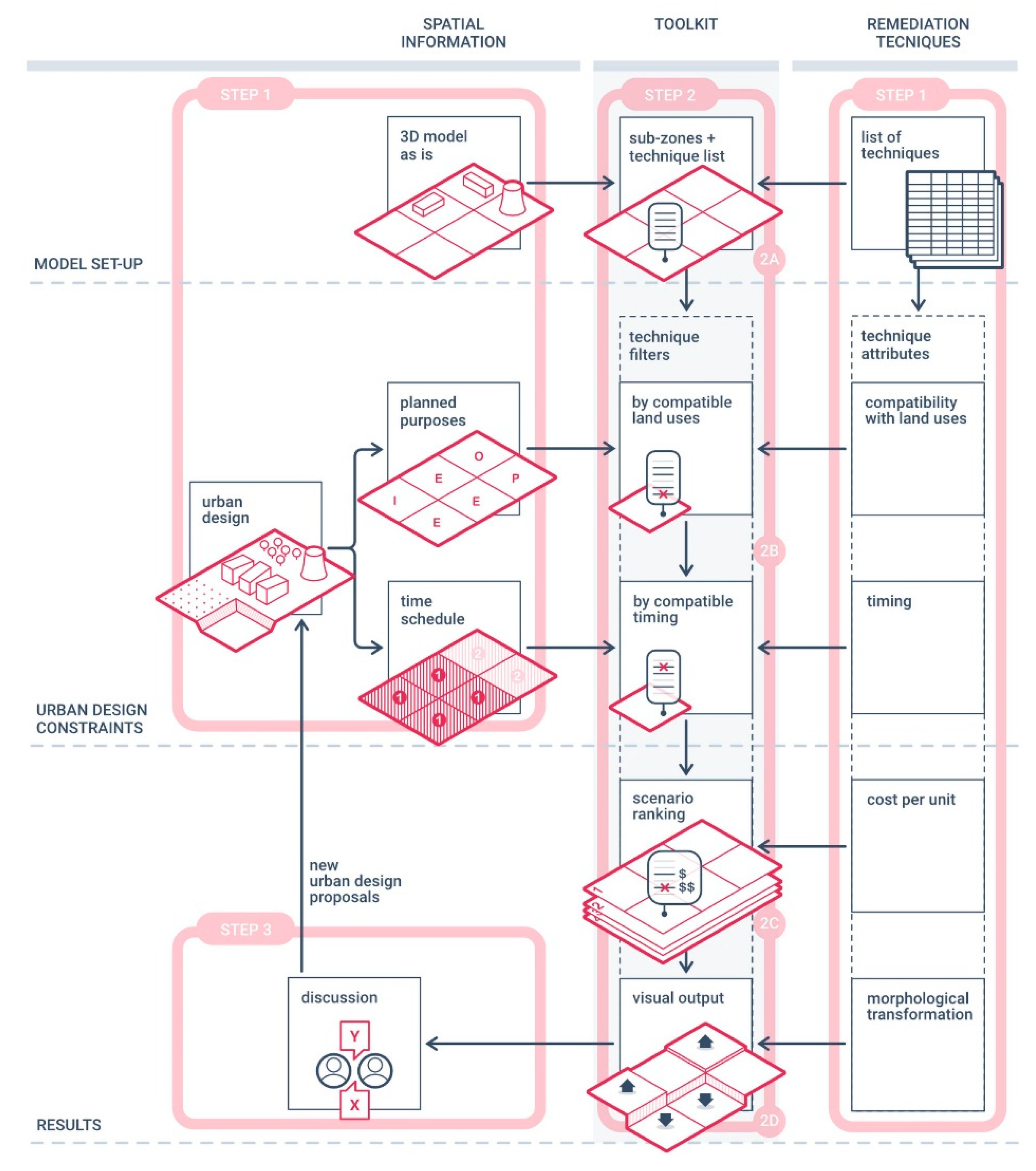
Figure 3.
The two different urban design plans A and B for the Nitrastur application.

Table 1.
Subzones’ input data in AdRem based on remediation and urban design constraints.
| Group | Attribute | Description | Values |
|---|---|---|---|
| Remediation technologies | Produced morphological transformations | Changes to the ground surface of the site as a result of the remediation activities | - |
| 0 | |||
| + | |||
| Compatibility with expected land use(s) | Compatibility with the architectural project and the future destination of the area (e.g., maintenance of the pre-existing building) | True | |
| False | |||
| Timing | Time required to clean up a standard site using the technology | <5 years | |
| ≥5 years | |||
| Estimated unitary cost | Choice of techniques based on average unit costs, without taking into account the economy of scale | Euros per unit volume or unit area | |
| Urban planning | Spatial characteristics | Geometric definition of the site (3D model in Rhinoceros) | Derived from 3D model (coordinates, area, pre-existing buildings) |
| Planned purposes | Excavations (i.e., foundations, underground parking, soil movements) | E | |
| Impermeable surfaces (i.e., parking lots, paved spaces) | I | ||
| Areas in which existing buildings are preserved | P | ||
| Other planned uses | O | ||
| Priority | Areas to be reused within a five-year time span | Short term | |
| Areas to be reused within a longer period | Long term |
Table 2.
Results of the decision-making process provided by the toolkit following the application of Plan A on the Nitrastur site. For planned purposes: E = excavation; I = impermeable surface; P = areas in which existing buildings are preserved; O = other planned uses.
Table 2.
Results of the decision-making process provided by the toolkit following the application of Plan A on the Nitrastur site. For planned purposes: E = excavation; I = impermeable surface; P = areas in which existing buildings are preserved; O = other planned uses.
| Plan A | |||||
|---|---|---|---|---|---|
| Sub-Zone | Planned Purpose | Priority (Years) | Remediation Technology | Cost for Each Sub-Zone | Morphological Variation |
| S01 | E | <2 | Excavation and soil washing | 658,240 € | - |
| S02 | E | <2 | Excavation and soil washing | 1,424,060 € | - |
| S03 | E | <2 | Excavation and soil washing | 1,472,460 € | - |
| S04 | P | <2 | In situ stabilization | 1,598,000 € | 0 |
| S05 | P | <2 | In situ stabilization | 2,006,125 € | 0 |
| S06 | I | <2 | Capping | 187,740 € | + |
| S07 | O | ≥2 | Phytoremediation | 69,400 € | 0 |
| S08 | O | ≥2 | Phytoremediation | 98,770 € | 0 |
| S09 | O | ≥2 | Soil flushing | 1,000,000 € | 0 |
| S10 | P | ≥2 | Soil flushing | 804,000 € | 0 |
| S11 | O | ≥2 | Soil flushing | 929,400 € | 0 |
| S12 | O | <2 | Excavation and disposal | 4,000,000 € | - |
| S13 | I | ≥2 | Capping | 171,280 € | + |
| S14 | P | ≥2 | Phytoremediation | 59,170 € | 0 |
| S15 | P | <2 | In situ stabilization | 2,074,750 € | 0 |
| S16 | P | <2 | In situ stabilization | 1,870,000 € | 0 |
| S17 | P | <2 | In situ stabilization | 1,120,000 € | 0 |
| S18 | O | <2 | Excavation and soil washing | 2,200,000 € | - |
| S19 | O | <2 | Excavation and soil washing | 2,022,020 € | - |
| S20 | I | <2 | Capping | 148,700 € | + |
| Total Cost: | 23,914,115 € | ||||
Table 3.
Results of the decision-making process provided by the toolkit following the application of Plan B on the Nitrastur site. For planned purposes: E = excavation; I = impermeable surface; P = areas in which existing buildings are preserved; O = other planned uses.
Table 3.
Results of the decision-making process provided by the toolkit following the application of Plan B on the Nitrastur site. For planned purposes: E = excavation; I = impermeable surface; P = areas in which existing buildings are preserved; O = other planned uses.
| Plan B | |||||
|---|---|---|---|---|---|
| Sub-Zone | Planned Purpose | Priority (Years) | Remediation Technology | Cost for Each Sub-Zone | Morphological Variation |
| S01 | O | ≥2 | Soil flushing | 299,200 € | 0 |
| S02 | O | ≥2 | Soil flushing | 647,300 € | 0 |
| S03 | O | ≥2 | Soil flushing | 669,300 € | 0 |
| S04 | I | <2 | Capping | 127,840 € | + |
| S05 | I | <2 | Capping | 160,490 € | + |
| S06 | P | <2 | In situ stabilization | 2,346,750 € | 0 |
| S07 | E | ≥2 | Phytoremediation | 69,400 € | 0 |
| S08 | E | ≥2 | Phytoremediation | 98,770 € | 0 |
| S09 | E | <2 | Excavation and soil washing | 2,200,000 € | - |
| S10 | P | <2 | In situ stabilization | 2,010,000 € | 0 |
| S11 | I | <2 | Capping | 185,880 € | + |
| S12 | O | <2 | Excavation and disposal | 4,000,000 € | - |
| S13 | P | ≥2 | Soil flushing | 856,400 € | 0 |
| S14 | P | ≥2 | Phytoremediation | 59,170 € | 0 |
| S15 | P | ≥2 | Soil flushing | 829,900 € | 0 |
| S16 | P | ≥2 | Soil flushing | 748,000 € | 0 |
| S17 | P | ≥2 | In situ stabilization | 448,000 € | 0 |
| S18 | O | ≥2 | Excavation and soil washing | 2,200,000 € | - |
| S19 | O | ≥2 | Excavation and soil washing | 2,022,020 € | - |
| S20 | P | <2 | In situ stabilization | 1,858,750 € | 0 |
| Total Cost: | 19,534,250 € | ||||
Publisher’s Note: MDPI stays neutral with regard to jurisdictional claims in published maps and institutional affiliations. |
© 2020 by the authors. Licensee MDPI, Basel, Switzerland. This article is an open access article distributed under the terms and conditions of the Creative Commons Attribution (CC BY) license (http://creativecommons.org/licenses/by/4.0/).
Share and Cite
MDPI and ACS Style
Palma, V.; Accorsi, F.; Casasso, A.; Bianco, C.; Cutrì, S.; Robiglio, M.; Tosco, T. AdRem: An Integrated Approach for Adaptive Remediation. Sustainability 2021, 13, 28. https://doi.org/10.3390/su13010028
AMA Style
Palma V, Accorsi F, Casasso A, Bianco C, Cutrì S, Robiglio M, Tosco T. AdRem: An Integrated Approach for Adaptive Remediation. Sustainability. 2021; 13(1):28. https://doi.org/10.3390/su13010028
Chicago/Turabian StylePalma, Valerio, Federico Accorsi, Alessandro Casasso, Carlo Bianco, Sarah Cutrì, Matteo Robiglio, and Tiziana Tosco. 2021. "AdRem: An Integrated Approach for Adaptive Remediation" Sustainability 13, no. 1: 28. https://doi.org/10.3390/su13010028
Note that from the first issue of 2016, this journal uses article numbers instead of page numbers. See further details here.