Geomorphological Map and Quaternary Landscape Evolution of the Monfragüe Park (Cáceres, Spain)


Department of Geology, Faculty of Sciences, Plaza de la Merced s/n, University of Salamanca, 37008 Salamanca, Spain
*
Author to whom correspondence should be addressed.
Sustainability 2020, 12(23), 10099; https://doi.org/10.3390/su122310099
Submission received: 20 September 2020
/
Revised: 3 November 2020
/
Accepted: 2 December 2020
/
Published: 3 December 2020
(This article belongs to the Special Issue Geological Heritage and Biodiversity in Natural and Cultural Landscapes)
Abstract
:From the geomorphological cartography, the geometric and spatial distribution of the quaternary forms and deposits are analyzed, with special relevance to the fluvial terraces that allow obtaining the chronology of the successive landscape changes of the course of the Tagus River attributed to the activity of the Fault of Alentejo-Plasencia (APF). The “Appalachian” relief of Monfragüe National Park, constituting a series of quartzitic combs with direction NW, between which they find slopes, hills and valleys following the same direction, for the dismantlement of the Cenozoic cover that was covering the substratum (still present in the central sector) and encasement of the Rivers Tagus and Tiétar. The remains of fluvial terraces inside and outside the Park stand out at different heights and so they originate from different times and show different landscapes along the routes of the Tagus river and its movement over time. In the north end (basin of the Campo Arañuelo), there are remains of ten fluvial terraces of relative importance attributed to the River Tagus (with heights relative to the thalweg between 120 and 20 m). In the south edge, there are eight levels attributed to a former fluvial drainage network, which assimilates to the River Tagus, with the more recent level reaching over 280 m on the current river. Neotectonics readjustments that rejuvenated the relief produced the elevation of the socle and cover, at the time of diversions in the path of the fluvial network, up to the structure and encasement (for supertax and/or antecedence). During the Quaternary, the activity of the Alentejo-Plasencia Fault (APF) has given rise to palaeogeographic changes in the fluvial valley of the Tagus River. During the ancient Lower Pleistocene, its course passed south of the current one (Talaván-Torrejón el Rubio basin); at the end of the Lower Pleistocene, it came out crossing the syncline through the Boquerón porthole, and the meander that bordered the town of Almaraz was abandoned; at the beginning of the Middle Pleistocene, it changes its direction, from NE–SW to SE–NW, leaving the porthole and joining the Tiétar river within the Park; later it moves somewhat to the south. These changes in the route and the anomalous fitting of the course of the Tagus River into the Paleozoic substrate, have been attributed to the APF, which, through impulses, has had a great activity from the Lower Pleistocene to the Middle Pleistocene.
1. Introduction
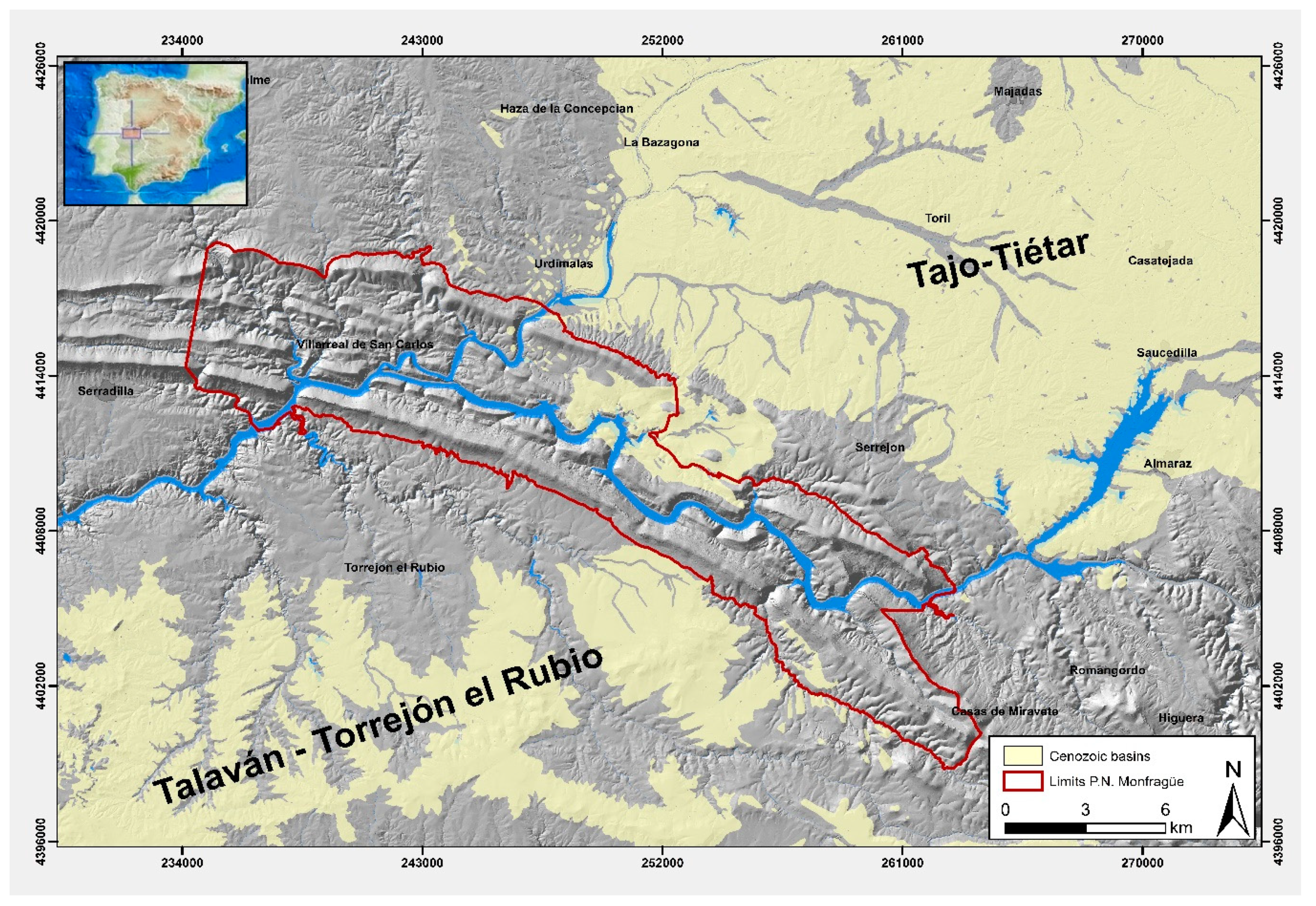
The Monfragüe National Park (MNP), located in the center-west of the Iberian Peninsula, represents an area to the north of the province of Cáceres, in the shape of an arch, which belongs to the geological unit of the Iberian Massif and within it to the Central-Iberian Zone. Its limits span to the north to the Campo Arañuelo Basin, to the south with the Extremeña Peneplane and the Talaván Basin, to the east with Las Villuercas and Montes de Toledo, of which it forms part, and to the W with the Neogene Basins of Cañaveral and Plasencia, originated by the Alentejo-Plasencia Fault (APF) (Figure 1).
The relief consists of a set of elongated mountain ranges and valleys with a predominant NW–SE direction giving rise to a type of “Appalachian” modeling, characterized by successive alternations of quartzites, sandstones and slates of the Paleozoic series, folded in the Variscan orogeny, devastated during the Mesozoic and rejuvenated in the alpine and post-alpine cycle.
At the level of geological formations, it falls within the geological unit of the Hesperian Massif [1], currently the Iberian Massif within the Vertical Folds Domain of the Central-Iberian Zone [2]; it is composed mainly of metamorphic rocks of the Paleozoic series (Ordovician and Silurian) folded and fractured during the Variscan orogeny, which is covered in some sectors by younger Cenozoic and Quaternary sedimentary materials. The whole complex was reactivated during the Alpine orogeny. The relief is related to differences of erodibility owing to the alternation and arrangement of its materials, the neotectonics and quaternary morphogenetic processes [3,4,5]. Especially noteworthy are the series of mountainous alignments, which stand out on the wide Extremadura peneplain, and the water network that runs through it, whose waters flow directly or indirectly to the Tagus River.
The environmental characteristics of this area have served for its declaration as a Natural Park (1979), Spatial protection zone for birds (ZEPA) (1998), Biosphere Reserve (2003) and finally a National Park (2006). This recognition of ecological values has not been followed by the recognition of its geological values, nor the geomorphological character of its landscapes.
The fundamental elements of the relief (ridges, hills, valleys and surfaces), are accompanied by other quaternary geomorphological units: colluviums, scree and foothills (linked to ridges and escarpments, waterfalls, portholes, river terraces, alluvial fans and glacis, related to the river network of the Park.
In the last decade, the detailed analysis of geomorphological cartography [6,7,8,9,10] aided by absolute and relative dating techniques, allows establishing temporal sequences that enable the interpretation of the changes in the relief and therefore the landscape generated in each temporal stage from the field study of the modeling and structures generated by external geodynamic agents (water, wind, ice, etc.) and the processes and genesis of the existing forms on the ground (erosion and deposit).
From the analysis of sequences in cross-sectional profiles of the river valleys of the rivers of the Neogenes basins of the Iberian Peninsula, mainly the Tagus basin and Duero basin, general sequences of river terraces with their topographic height in relation to the fluvial course (thalweg) are elaborated, correlating the rivers of the same basin and similar basins such as the Tajo basin. In parallel, the terraces are dated using different methods (isotopic, radiogenic, chemical-biological, geomorphological-edaphic, etc.) and correlations (paleontological with macro-microfauna and pollen, archaeological, paleomagnetic, and stable isotopes to correlate paleoenvironments). The most relevant articles, among others, that have been taken into account refer to sequences for the Iberian Peninsula [11], Tagus basin sequences [12,13,14] and Duero basin sequences [15,16,17,18] and sequences for Tagus-Duero basins [19,20]
The objective of this work is to carry out a detailed geomorphological cartography, which allows the interpretation of the different landscapes of the Quaternary and to determine its palaeogeographic evolution. Based on the spatial position of the quaternary fluvial deposits (terraces) and their correlation with sequences from the same Tagus Basin or with basins whose behavior is similar (Duero Basin), create a relative chronology that helps us to determine the ages of the paleogeographic changes of the river course of the Tagus river and as a consequence of the moments of activity of the Alentejo-Plasencia Fault.
The importance of this work lies, in addition to its geomorphological cartography, in that it refers to important changes in the Quaternary paleo-landscape, pointing out five major paleogeographic changes in the river valley of the Tagus River, which occurred in a reduced time interval, since the Lower (Middle) Pleistocene to the Middle Pleistocene (ancient), due to the activity in this period of time, of the APF.
2. Materials and Methods
To prepare the geomorphological map, a bibliographic review of the existing works was carried out, accompanied by field and office tasks (photointerpretation and GIS analysis), and along three stages (Figure 2):
Stage 1: The geological framework was analyzed [21,22,23,24,25,26,27,28,29], with the description of the different lithologies and structures that it comprises and the elaboration of the simplified geological layer, using the geological units that are needed for the geomorphological map. From here, the geology of the area is reinterpreted, especially the part corresponding to the Quaternary deposits.
Stage 2: Preparation of the map of Geomorphological Units from existing works [30,31,32,33,34], especially the cartographic ones that bring us closer to the different units of the relief [4,5], then performing the geomorphological photointerpretation and the necessary field survey.
In the representation of the landforms in the legend of the Geomorphological Map, the erosive forms are separated from the depositional forms: fluvial (streams), gravitational, morphostructural, lacustrine (marsh), alteration and mixed (polygenic), giving them a geomorphological symbol with the characteristic color of each morphogenetic system common in this type of cartography. Light colors are chosen, for better contrast with the surface patterns.
Another aspect to consider is the analysis of the Quaternary deposits from the point of view of their age (chronology) based on the sequences of the fluvial terraces of the two rivers that cross the area (Tagus and Tiétar), obtaining a relative chronology comparable to those deduced in other areas of the Tagus and Duero Basins, where paleomagnetic, radiogenic (ESR, TL, OSL), isotopic (cosmogenic nuclides), paleontological dates, etc. [12,17,18,19,20,35], geomorphology (heights of the terraces, soils, cementations, etc.) and correlations based on the heights of significant scarps [36] data are available.
In the study area, these deposits have been differentiated as Lower, Middle, Upper Pleistocene and Holocene ages. To represent this chronology, the methodology of the Geological and Mining Institute of Spain has been used, which allowed us to give a relative age to both the deposits and associated forms.
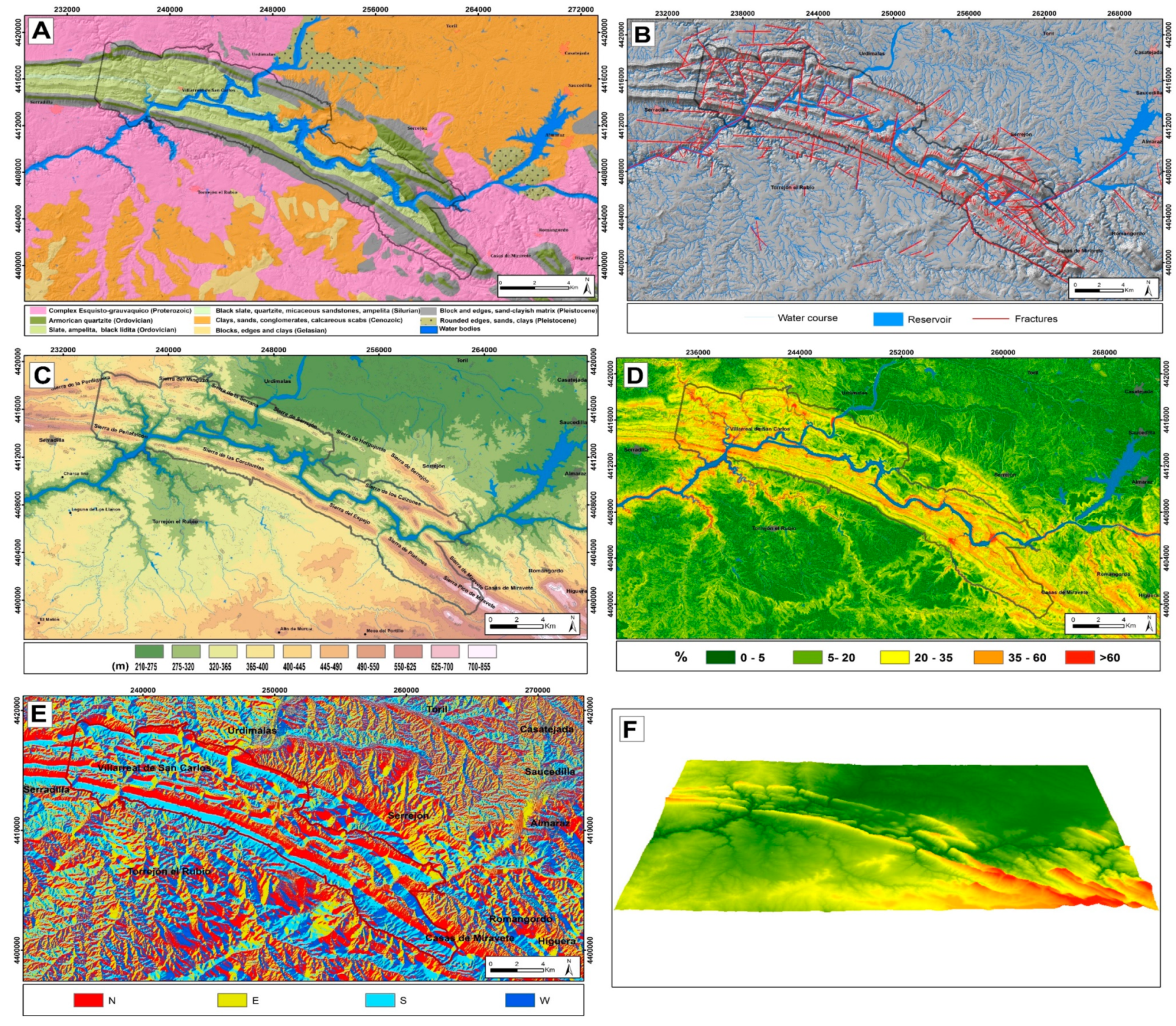
Within the geomorphological map, although they are important, we have not used frames to differentiate neither the various substrates, nor the tectonic signs for the geological structures (only some faults, with a dashed line), so as not to complicate their reading, lithology and fractures maps. In this last map it can be observed how fractures favor the entrances and exits of the rivers to the Park through fluvial gorges (portholes). The other auxiliary maps (elevations, slopes and aspect) complement other aspects of geomorphology, such as characterizing the relief and including the basic toponymy. The next maps will allow us to appreciate clearly where the drainage network fits more or less, and relate it to the areas that have suffered a greater neotectonic uplift, which can be seen in the NW and SE of the Park as compared to the center. The last auxiliary map is used for analyzing recent (active) processes and their relationship with the climate; in this case, it is observed that the dominant orientations are NE and SW, which condition soils, vegetation and landscapes (Figure 3).
Stage 3: The geomorphological layer, involved the detailed digitization of the Park and its surroundings at 1:50,000 using ArcGIS. The spatial resolution of the DTM of 5 m and National Plan for Aerial Orthophotography (PNOA) Orthophotos of maximum actuality at 1:10,000, allowed a greater cartographic detail.
Process sequences are established, based on the geometric and spatial arrangement of the deposits with respect to the terrace levels, using the altimetric data from the Terrain Digital Model—TDM. Each group of forms with the same genetic origin (structural, fluvial, polygenic, gravitational, lake and alteration) is represented with a color, using the internationally recognized colors for geomorphological units. The shadow map is used as background, accompanied by a selection of contour lines, the drainage network and some toponymy elements (municipalities and quarries) extracted from the national topographic maps at a scale of 1:25,000 of the National Geographic Institute.
From the TDM, complementary maps that provide information have been generated to characterize units and interpret the evolution of the regional relief. Finally, the limit “of the area of the MNP and zone of influence” is incorporated. After the integration of all layers, the map of geomorphological units is generated, which records the presence, distribution and extension of the morphostructural and morphogenetic units, related to the neotectonic and morphodynamic processes that have operated in the region since the Late Neogene and, especially, during the Quaternary and, eventually, define the landscape evolution during time (Figure 4).
3. Results
The geomorphological cartography (Figure 4) obtained from photointerpretation and field work allows an analysis of geomorphological features that can be synthesized in the following sections:
3.1. Morphostructural Modeling
This modeling is dominated by an “Appalachian” type relief that is the result of differential erosion of the ancient relief, presenting as a general characteristic three highly competent quartzite sequences, which constitute a large syncline in E–W direction with a significant convergence towards the south. These sequences they give rise to the most pronounced reliefs (ridges) with heights above 500 m for the Armorican Quartzite and lower values, around 400 m and 300 m, for the Caradoc and Criadero Quartzites, respectively. These are separated by less competent materials (sandstones and slates), which favor slopes, hills and river valleys following the same synclinal pattern (Figure 5). Partial individualizations of the general model are observed, due to bifurcations of layers, descents and/or elevations of the edges of the folds, asymmetry of these, and the existence of NE–SW faults that displace the layers (examples of Loma del Diablo and Sierra de Herguijuela), which modify the alignment of the mountains, singling out the modeling, which acquires its own pattern. The fracture systems, controlled by alpine and neotectonic movements, have affected the general curvature of the park and the development of the river network (Figure 6 and Figure 7A).
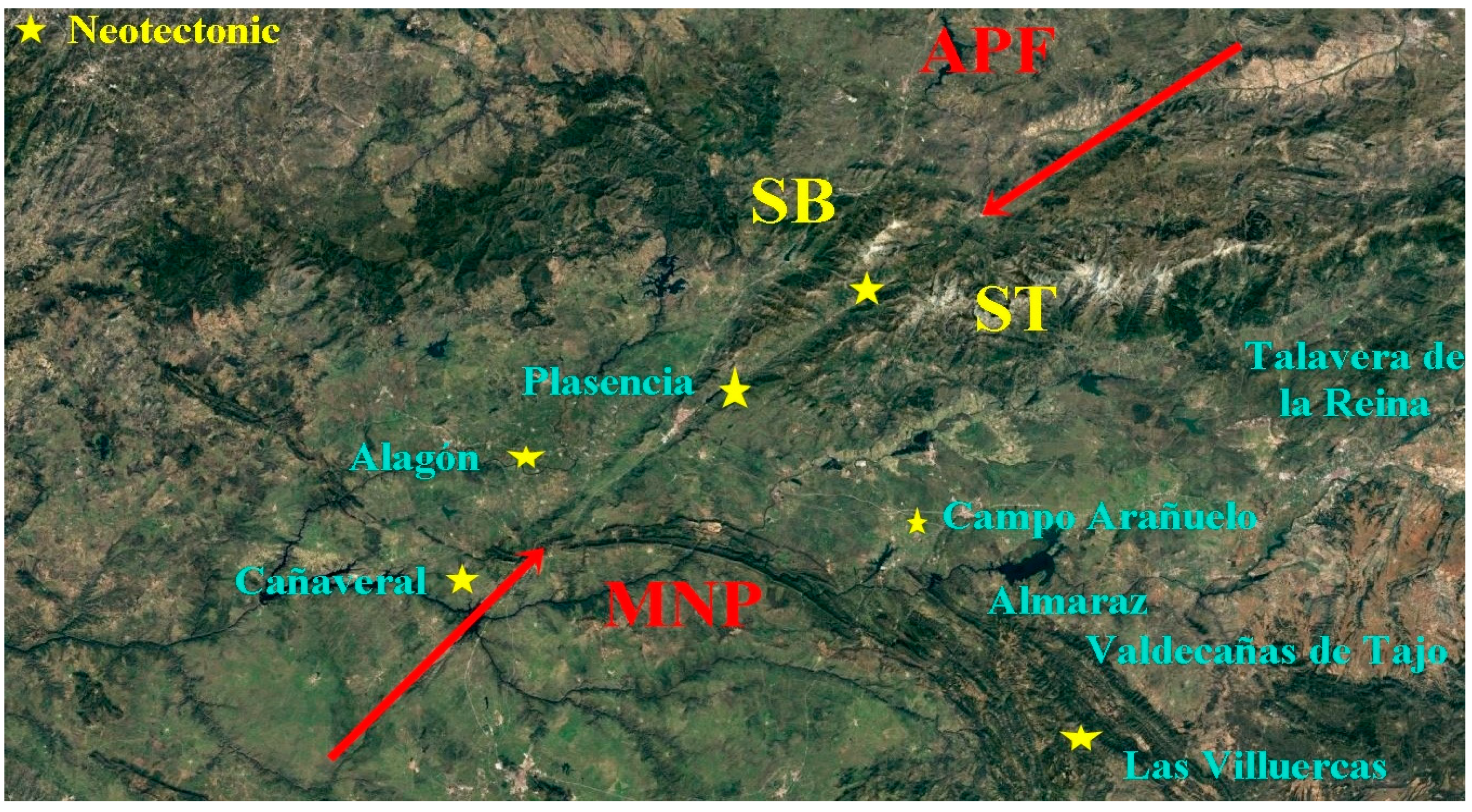
Neotectonics are reflected in geomorphological indicators of nearby areas (Figure 6). The western sector of the Park is affected by the crossing of the Alentejo-Plasencia Fault (APF) that affects the Paleozoic materials, curving them convexly to the north and that Villamor (2002) [33,34] considers as a segmented synaesthetic tear failure, with evidence of movements during the Quaternary and low displacement rates, less than 0.1 (probably between 0.01 and 0.05 mm/y). Other indicators are the tilted Neogene deposits of the Plasencia and Cañaveral pull-apart basins [33], the lower and middle Pleistocene fractured river terraces in the Cañaveral basin [34]; the geomorphological anomalies indicative of recent tectonics [35,36] affecting the terraces of the Alagón River, NW of the Park, with anomalous elevations (+218 m, Cerro Marifranca), for the oldest terrace (beginning of the Lower Pleistocene); its slope: in favor (+70 m-Mesa del Val), beginning of the middle Pleistocene and counter slope (40–45 m, Los Llanos) in the middle of said Pleistocene, which promote lagoons due to poor drainage; changes in the direction of the course of said river, from NE–SW during the Lower Pleistocene and the middle of the Middle Pleistocene, to N–S; the 90° turn (from N–S to E–W) of the Alagón del Río riverbed when approaching the APF is also anomalous. The right-angle turn of the Jerte river in Plasencia (NE-SE to SE-NE), and the lack of old levels is anomalous compared to the Alagón river a few kilometers away; the tectonized terraces in the Jerte Valley and the asymmetry of the valley, a greater number of terraces on its right bank, when moving towards the fault (to the SE); the relief of Las Villuercas reactivated in the Pliocene, the deformed Paleogene and Neogene deposits in the Campo Arañuelo basin and the displacement of the Tiétar River to the NW, as a consequence of the sinking of the northern part of this basin [11]. According to this activity it has been included as an active fault in the database of active faults of the Iberian Peninsula.
From the fracture map (Figure 3B), it can be deduced that the most abundant fault systems are the NNE–SSW to NE–SW and the N–S, and to a lesser extent the E–W and NW–SE. Many of these fractures condition the drainage network by rectifying water courses, giving rise to anomalous elbows, diverting ridges and hills, causing fault scarps, faceted faces and river gorges at the entrance and exit of the rivers to the Park (Gorges or Fluvial Portholes) (Figure 8).
3.2. Quaternary Modeling
Throughout the Quaternary, fluvial dynamics played a major role, although at certain times the gravitational processes favored by periglacial environments also contributed.
3.2.1. River Modeling
The fluvial morphogenetic system is formed by the Park’s water network, made up of the Tagus and Tiétar rivers, streams and tributary gorges (Malvecino, Barbaón, Calzones, de la Vid, del Cubo, etc.), clearly conditioned by the lithology and the fracture systems, presenting as a whole a “lattice drainage” pattern (Figure 3B and Figure 4). All the courses run incised in the layers of shale and sandstone, forming V-shaped valleys, with river scarps marked in certain sectors (Figure 5).
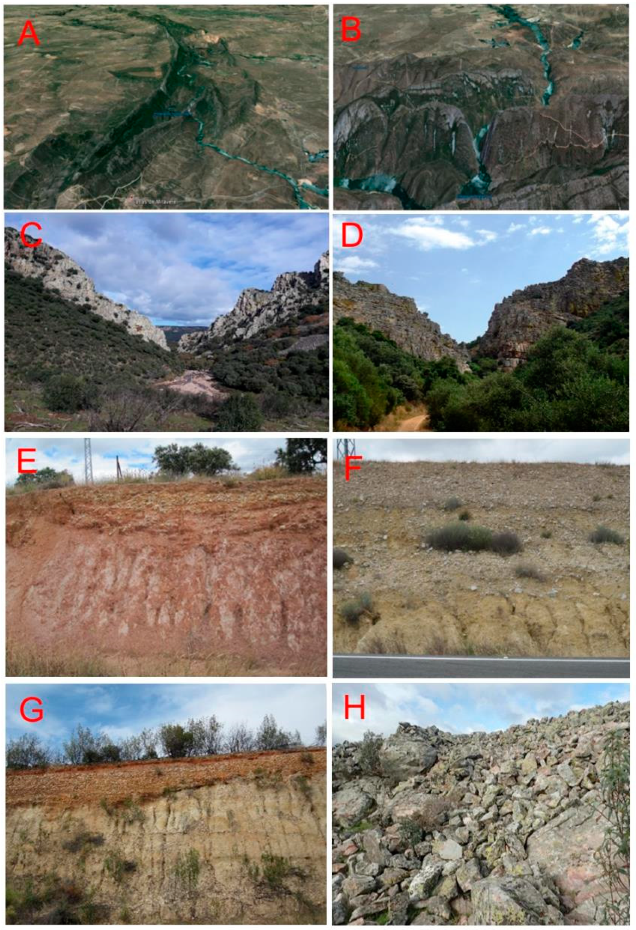
The gorges (portholes) of La Garganta or Fraile (Figure 7D), affected by a recent fracture that has originated an important tectonic step which stands out, that of Tiétar (at the entrance of the river) and these of Corzo (Figure 7B) and Salto del Gitano (Tagus porthole) exit of the Tagus and Tietar Rivers, respectively (Figure 4 and Figure 8). In addition, the change of direction of the La Garganta and Cubo streams, which border the park’s SW flank parallel to the Armorican quartzite, incised in the Extremadura peneplain, and turn towards the interior, crossing the Armorican quartzite (Boquerón porthole) (Figure 7C) with an S-N course. These changes in direction have been favored by an NE–SW fracture and the uplift of the block located SE of the Park (Figure 8)
During the Quaternary, the rivers were deeply incised in the underlying rocks and currently there are hardly any remains of their deposits (terraces) within the synclinal megastructure (only in the central-eastern sector) where some hanging terraces have been detached from the current channels, which would imply a change in the course of the Tagus River during the Quaternary (Figure 4).
The most significant fluvial forms in the cartography are the fluvial terraces (Tagus and Tiétar rivers) (Figure 7F,G), alluvial fans and pediment (glacis). The Tagus River is the main artery that crosses the Park from SW to NE, from Salto del Corzo to the Tagus porthole (Salto del Gitano). The sequences of terraces have been analyzed before entering the MNP, inside and after leaving it, synthesizing them in 18 levels, encased in the system of ancient alluvial fans (beginning of the Quaternary), called “Rañas” (Figure 7E) that constitute the beginning of the river encasement, as Neogene basins became exoreic. The oldest terraces are found in the Talavan-Torrejon el Rubio Basin, in the southern sector, outside the Natural Park, where eight levels have been recognized (six of them recorded in this cartography and two, immediately to the west, to the S of Cañaveral) (Figure 4 and Figure 8). Nowadays they are detached from the channel as remains of a previous course of the Tagus river during the Lower Pleistocene, before the present emplacement.
On the edges of the Neogene basin (S of Campo Arañuelo), before entering the Park, to the east and SW of Almaraz, there are remains of ten relatively large river terraces that we have related to the Tagus River (with elevations relative to the talweg between +120 and +20 m), and ages ranging from the Upper Lower Pleistocene to the Upper Pleistocene. The old terraces (on both banks) of this section do not correspond to the Tagus valley, which is an abandoned meander of the east river (Arrocampo creek)
The levels within the Park crop out between +70 and +20 m correspond to the six most recent of the previous section. Between the levels at +70 m and +60 m there is an abandoned channel (Figure 4 and Figure 8H).
General sequence: Lower Pleistocene: Raña- +310 m; Terraces: T1- +288 m; T2- +275 m; T3- +260 m; T4- +243 m; T5- +232 m, T6- +200 m; T7- +160 m; T8- +150 m; (first change of the river course), T9- +120 m; T10- +112 m; T11- +100 m; T12- +90 m; (second change); Middle Pleistocene: T13- +70 m; (third change); T14- +60 m; T15- +50 m; T16- +40 m; Upper Pleistocene: T17- +30 m; T18- +20 m. The three sectors analyzed correspond to changes in the river course.
The Tiétar River has a sequence of 12 levels that range from late Lower Pleistocene to Holocene (Figure 4 and Figure 8).
General sequence: Lower Pleistocene: T1- +100 m; T2- +90 m; T3- +80 m; T4- +70 m; Middle Pleistocene: T5- +60 m; T6- +50 m; T7- +40 m; T8- +30 m; Upper Pleistocene: T9- +20 m; T10- +15 m; T11- +10 m; Holocene: T12- +4 m.
The other relevant fluvial forms (mapped) are the alluvial fans and cones and the pediment (glacis) (Figure 5 and Figure 7). They are deposits originated by non-channeled waters and among the first we must point out the “rañas” that, as said before, are dated as Early Pleistocene (Gelasian) and serve as the origin of the fluvial sequences. This deposit is found at +310 m in the eastern sector of the Talaván-Torrejón El Rubio basin, discordant on the Cenozoic arkoses and on the Proterozoic and Paleozoic substrate (outside the Park) composed of sub-rounded wedges of quartzite and quartz with a red, sandy-clay matrix. The alluvial cones and fans of Middle, Upper Pleistocene and Holocene ages are related to the Tiétar river valley to the north of the syncline, composed of sub-rounded clasts of quartz, granite, and schists in a sandy-clay matrix.
The most representative systems of cover glacis are found in the eastern part of the Talaván-Torrejón El Rubio Basin, also associated with the slopes of the Sierras de las Conchuelas, del Espejo and Pico de Miravete and to the north hills of the Sierras de Serrejón and Herguijuela. In the first case, the change in the course of the Tagus River, in Lower Pleistocene times, favored the formation of three encased glacis, associated with secondary streams (they represent connecting slopes) such as El Retuerta and La Vid. These deposits consist of a sandy-clay matrix with wedges of sub-rounded quartzite clasts.
3.2.2. Gravitational Modeling
The slopes of the quartzite ridges are covered by colluvium and scree, characteristic of the Pleistocene and Holocene periglacial environments.
The colluviums correspond to accumulations of medium and small quartzite, slate and sandstone cobbles encased in a sandy-clay matrix, downslope of the ridges which experienced mass displacement. Up to four sequences can be distinguished, related to different moments of the Quaternary (Upper Middle Pleistocene and Holocene).
The screes “Canchales term” are accumulations of medium-sized size (30 cm to 10 cm) angular blocks of quartzite, with little or no matrix, derived from the steep quartzite ridges, and arranged on colluviums during the Upper Pleistocene. They occur especially in the southern sector. The study and statistical treatment of these materials reveals a preferential orientation of major axes (NE/SW, NW/SE); suggesting that they are related to reactivations of the APF, which cause the reactivation of the stress fields [4]. Arched “lobes” and “detachment scars” are observed in the middle and lower parts of these formations, indicating post-depositional gelifluidal movements. All this points to a freeze–thaw environment typical of the cold periods of the Holocene (Figure 4).
On the surface of the peaks of the Sierra de Piatones, a “field of very angular blocks” was formed under periglacial conditions (freeze–thaw processes), by cryoclasty and gelifluction (Figure 7H).
3.2.3. Polygenic Modeling
On the slopes of the Sierras, to the north and south of the synform, there are deposits of mixed genesis partly fossilized by colluviums. Owing to their position and the type of transported material they have been called Piedmonts (Piedemontes). These are detrital deposits related to more or less steep quartzite reliefs, whose formation has been influenced by gravitational and stream processes. They appear associated with colluviums with ages ranging from late lower Pleistocene to Holocene.
In the Talaván-Torrejón el Rubio Basin, and to the NW of the Park, there are preserved remains of the Fundamental Penillanura. They consist of an old surface that erodes the Paleozoic materials of the schist-grauwaque complex, with a very gentle slope, caused by more than one morphogenetic process (Figure 7H).
4. Discussion: Paleogeographic Evolution
From the analysis of the cartography and the geomorphological features, the existence of major neotectonic movements can be deduced. These caused the displacement and uplift of the Monfragüe syncline, possibly between the end of the Neogene and middle, Middle Pleistocene (Figure 8). These explain the anomalous arrangement of terraces, the absence in the Park of ancient terraces of the Tagus river, the preservation of the Neogene cover in its central sector, the presence of abandoned channels within the Natural Park (witnessing changes in the main channel); the orientation of blocks in the scree areas and the Appalachian relief exhumed during the Quaternary could hardly be explained by climate change only. Figure 8 shows that, during the Lower Pleistocene, the Tagus River was located to the south of the present-day channel, close to the “raña” deposits, to the SE of the study area, near the current divide of the Tagus and Almonte, and that it was displacing towards the NW at that time. This figure also shows that, at the beginning of the Middle Pleistocene, the Tagus River channel was closer to the current river course, but not yet corresponding with it, producing minor changes before the accommodation in the underlying materials.
From the observation of the fracturing that affects the MNP materials, it can be deduced that the entire syncline that constitutes it has undergone bulging and curvature (Figure 4 and Figure 8), due to the movement of the APF, originating radial-type fractures (NNE–SSW and NNW–SSE) abundant in this sector, compartmentalizing ancient geological materials into blocks, which gave rise to movements of different magnitudes (Figure 8).
Another aspect to consider is the fluvial incision rates of the Tagus River in this area, comparing them with those of Talavera de la Reina, (approximately 100 km to the East), belonging to the Campo Arañuelo sub-basin (Figure 6). The elevation of the ancient alluvial fans “rañas” in relation to the current riverbed (talweg) in both areas have been taken as a reference. In the MNP it is at +310 m (Jaraicejo) and in Talavera de la Reina (Malpica) at +220 m above the current channel. As the age attributed by us to these deposits is Early Quaternary (Lower Pleistocene-Gelasian) 2588 Ma, the calculated values are 0.119 m/Ka for the Park area and 0.085 m/Ka for the Talavera de la Reina area. This difference (3.4 cm/y) is significant, almost 30% more, especially if we take into account that the geological substractum where the river is encased is more competent in the Park area (slates, sandstones and quartzites) than in the Talavera sector (arkose), so the difference is interpreted as a neotectonic effect.
These paleogeographic changes have been due to tectonic readjustments of the variscan fractures, reactivated in the Alpine and subsequent neotectonic movements, which generated displacements, uplifts, and tilts, that have favored the changes in the course of the Tagus River. As to the origin of the embedding of the river in the Appalachian relief, we propose a generalized uplift of the base materials during the Upper Pliocene and Quaternary (antecedents) since the river is established on the Neogene materials, and, when the neotectonic uplift occurs, it forces the materials to fit into said socket (superimposition), at the same time that erosion dismantles the Cenozoic materials, exposing those of the underlying Paleozoic.
- During the Lower-Ancient Pleistocene, the river flowed further south, in a general south-western direction, depositing a succession of terraces (T1- +288 m to T8- +150 m), in the Talaván-Torrejón el Rubio Basin, which are unrelated of the current course and river dynamics.
- In the Lower-Modern Pleistocene, the river course bordered the town of Almazán, forming a wide meander, currently occupied by the Arrocampo creek, with four levels of terraces on both margins (T9 + 120 m to T12 + 90 m). The river abandoned the meander between the Lower Pleistocene and the beginning of the Middle Pleistocene moving to the north of Valdecañas de Tajo, and rectified its course to an east–west direction.
- At this time, the river crossed the Park leaving it through the Boquerón porthole, attached to the relief and headed towards Torrejón el Rubio, where remains of this system of terraces are found near the town, to go through the current Retuerta river to converge with the Tiétar river that left the MNP through the Salto del Gitano. This old course had a path parallel to the current one.
- Between the Lower Pleistocene and the beginning of the Middle Pleistocene (as marked by terraces T12-90 m and T13-70 m), the Tagus River changed direction from NE–SW to SE–NW, in the Boquerón porthole, as a consequence of the uplift and tipping towards the north of the block formed by the Sierras de Piatones and Pico de Miravete (to the south) and Miravete (to the north), to join the Tiétar to the north of its current position. This can be deduced from the layout of the terraces, located north of its channel, and further confirmed by observing Figure 5a, which shows, for this section of the Park, a greater fit (age) of the Tiétar river bed than that of the Tagus river.This implies that the Tiétar River has maintained its course within the Park since the Lower Pleistocene and exited the Park area through the Salto del Gitano. In contrast, the Tagus River occupied its place around the Middle Pleistocene.
- During the Middle–Late Pleistocene (T13- +70 m-T14- +60 m), new movements forced the abandonment of the channel and the Tagus river moved to the south.
5. Conclusions
The elaborated geomorphological cartography, together with the auxiliary maps, has allowed a global vision of the evolution of the Quaternary landscape, from the analysis of the different forms, their geometric and spatial distribution, as well as the morphogenetic processes that have originated them, especially fluvial and morphostructural morphogenesis. This analysis makes it possible to elaborate a relative sequence of Quaternary deposits and forms.
During the Neogene, arcosic materials covered the structure of the Monfragüe synclinal that can still be seen in the north-central sector of the interior of the synclinal. This indicates a later dismantling of these materials due to the erosion caused by the fluvial networks of the Tagus and Tietar rivers, favored by the uplifting of the structure during the Quaternary.
The origin of this uplift is attributed to the reactivation of variscal fractures during the Alpine orogeny and by neotectonics (Pliocene and Quaternary) as well as the activity during all this time of the APF. The movement of this fracture has given rise to the northward curvature of the synclinal structure, its uplift and tipping of blocks, favoring the incision of the current river network and the displacement of the Tagus River.
The landscape of the current relief in the MNP has its origin in the lifting of the Paleozoic materials during the Pliocene and Quaternary, the installation of the drainage network (antecedent process) on the Neogenes materials and its incision on said materials to generate the superimposition of the river in the Paleozoic materials.
The spatial distribution of the terraces of the river Tagus (before and after the syncline) allows us to locate (in time) the changes in the course of the river’s fluvial course during the Pleistocene. There have been five major changes in the route of the River Tagus between the Upper and Middle Pleistocene.
The incision rates of the river course of the Tagus River and its large incision in the Paleozoic substrate (30% higher than the incision of the same river as it passes through the town of Talavera de la Reina 100 km to the east and upstream in the same basin) allow us to deduce a rise by means of impulses by the activity of the APF during the Quaternary.
The time of greatest neotectonic activity in the park occurred between the early Middle Pleistocene and the early Middle Modern Pleistocene.
Author Contributions
Conceptualization, J.L.G. and R.C.; methodology, J.L.G., R.C. and A.M.-G.; software, V.V.; validation, J.L.G., R.C. and A.M.-G.; formal analysis, J.L.G.; investigation, J.L.G., R.C. and A.M.-G.; resources, V.V.; data curation, J.L.G., R.C. and A.M.-G.; writing—original draft preparation, J.L.G., R.C. and A.M.-G.; writing—review and editing, J.L.G., R.C. and A.M.-G.; visualization, J.L.G., R.C. and A.M.-G.; supervision, A.M.-G. and M.Y.; project administration, A.M.-G.; funding acquisition, A.M.-G. All authors have read and agreed to the published version of the manuscript.
Funding
This research received no external funding.
Acknowledgments
This research was methodologically helped by project Junta Castilla y León SA044G18.
Conflicts of Interest
The authors declare no conflict of interest.
References
- Hernández, P.E. Síntesis Fisiográfica y Geológica de España; Trabajos del Museo Nacional de Ciencias Naturales: Madrid, Spain, 1934; p. 584. (In Spanish) [Google Scholar]
- Diez Balda, M.A.; Vegas, R.; González-Lodeiro, F. Structure of the Central Iberian Zone. In Pre-Mesozoic Geology of Iberia; Dallmeyer, R.D., Martínez García, E., Eds.; Springer: Berlin/Heidelberg, Germany, 1990; pp. 172–188. [Google Scholar]
- Gumiel, P.; Campos, R.; Segura, M.; Monteserín, V. Guía Didáctica del Parque Natural de Monfragüe; Junta de Extremadura: Mérida, Spain, 2003. (In Spanish)
- Soto Alonso, S. Cartografía Geomorfológica del Parque Nacional de Monfragüe, (Proyecto Fin de Carrera (Inédito)); University Alcalá de Henares: Madrid, Spain, 2006. (In Spanish) [Google Scholar]
- Goy, J.L.; Cruz, R.; Martínez-Graña, A.; Zazo, C. Geomorfología del Parque Nacional de Monfragüe: Cartografía y evolución Cuaternaria. In Proceedings of the XIII Reunión Nacional de Geomorfología, Cáceres, Spain, 12 September 2014; pp. 299–302. (In Spanish). [Google Scholar]
- Benito-Calvo, A.; Pérez-González, A. Erosion surfaces and Neogene landscape evolution in the NE Duero Basin (north-central Spain). Geomorphology 2007, 88, 226–241. [Google Scholar] [CrossRef]
- Forte, F.; Pennetta, L. Geomorphological Map of the Salento Peninsula (southern Italy). J. Maps 2012, 3, 173–180. [Google Scholar] [CrossRef]
- Karymbalis, E.; Papanastassiou, D.; Gaki-Papanastassiou, K.; Tsanakas, K.; Maroukian, H. Geomorphological study of Cephalonia Island, Ionian Sea, Western Greece. J. Maps 2013, 9, 121–134. [Google Scholar] [CrossRef]
- Migiros, G.; Bathrellos, G.D.; Skilodimou, H.D.; Theodoros, K. Pinios (Peneus) River (Central Greece): Hydrological-Geomorphological elements and changes during the Quaternary. Cent. Eur. J. Geosci. 2011, 3, 215–228. [Google Scholar] [CrossRef]
- Pérez-González, A.; Gallardo-Millan, J.L.; Uribelarrea del Val, D.; Panera, J.; Rubio-Jara, S. La inversión Matuyama-Brunhes en la secuencia de terrazas del río Jarama entre Velilla de San Antonio y Altos de la Mejorada, al SE de Madrid (España). Estud. Geológicos 2013, 69, 35–46. (In Spanish) [Google Scholar] [CrossRef]
- Santiesteban, J.; Schulte, L. Fluvial networks of the Iberian Peninsula: A chronological framework. Quat. Sci. Rev. 2007, 26, 2738–2757. [Google Scholar] [CrossRef]
- Cunha, P.P.; Almeida, N.; Aubry, T.; Martins, A.A.; Murray, A.S.; Buylaert, J.-P.; Sohbati, R.; Raposo, L.; Rocha, L. Records of human occupation from Pleistoceneriver terrace and aeolian sediments in the Arneiro depression (Lower Tejo River, central eastern Portugal). Geomorphology 2012, 165, 78–90. [Google Scholar] [CrossRef]
- Pérez-González, A.; Silva, P.G.; Calvo, J.P.; de Vicente, G.; González Casado, J.M. Mapa Geológico de España, E. 1:50,000 (2ª Serie); Talavera de La Reina n° 627; Instituto Geológico y Minero de España: Madrid, Spain, 2009. (In Spanish) [Google Scholar]
- Rosina, P.; Voinchet, P.; Bahain, J.J.; Cristanao, J.; Falgueres, C.H. Dating the onset of Lower Tagus River terraces formation using electron spin resonance. J. Quat. Sci. 2014, 29, 153–162. [Google Scholar] [CrossRef]
- Moreno, D. Datation par ESR de Quartz Optiquement Blanchis(ESR-OB) de la Région de Atapuerca (Burgos, Espagne). Applicationau Site préhistorique de Gran Dolina (Contexte Karstique) et Auxsyste‘mes Fluviatiles Quaternaires de l’Arlanzon et l’Arlanza. Ph.D. Thesis, Universitat Rovira i Virgili, Tarragone, Spain, 2011. [Google Scholar]
- Benito-Calvo, A.; Ortega, A.I.; Navazo, M.; Moreno, D.; Pérez-González, A.; Parés, J.M.; Bermúdez de Castro, J.M.; Carbonell, E. Evolución geodinámica pleistocena del valle del río Arlanzón. Implicaciones en la formación del sistema endokásrtico y los yacimientos al aire libre de la Sierra de Atapuerca (Burgos, España). Boletín Geológico y Min. 2018, 129, 59–82. (In Spanish) [Google Scholar] [CrossRef]
- Goy, J.L.; Rodríguez López, G.; Martínez-Graña, A.M.; Cruz, R.; Valdés, V. Geomorphological Analysis Applied to the Evolution of the Quaternary Landscape of the Tormes River (Salamanca, Spain). Sustainability 2019, 11, 7255. [Google Scholar] [CrossRef] [Green Version]
- Martín-Martín, I.; Gabriel-Silva, P.; Martínez-Graña, A.M. Geomorphological and Geochronological Analysis Applied to the Quaternary Landscape Evolution of the Yeltes River (Salamanca, Spain). Sustainability 2020, 12, 7869. [Google Scholar] [CrossRef]
- Roquero, E.; Silva, P.G.; Zazo, C.; Goy, J.L.; Masana, J. Soil evolution indices in fluvial terrace chronosequences of Central Spain (Tagus and Duero fluvial basins). Quat. Int. 2015, 376, 101–113. [Google Scholar] [CrossRef]
- Silva, P.G.; Roquero, E.; López-Recio, M.; Huerta, P.; Martínez-Graña, A.M. Chronology of fluvial terrace sequences for large Atlantic Rivers in the Iberian Peninsula (Upper Tagus and Duero drainage basins, Central Spain). Quat. Sci. Rev. 2016, 166, 188–203. [Google Scholar] [CrossRef]
- Martin, D.; Bascones, L.; Corretge, L.G. Cartografía y Memoria del Mapa Geológico de España E: 1/50,000 (2ª Serie). Cañaveral (650); Instituto Geológico y Minero de España (IGME): Madrid, Spain, 1987. (In Spanish) [Google Scholar]
- Contreras, E.; Roldán, F.J.; Sánchez, R. Cartografía y Memoria del Mapa Geológico de España E:1/50,000 (2ª Serie) de Navalmoral de la Mata (624); Instituto Geológico y Minero de España (IGME): Madrid, Spain, 2006. (In Spanish) [Google Scholar]
- Gumiel, P.; Arias, M.; Monteserín, V.; Segura, M. Modelo geológico 3D de la estructura en sinforme de Monfragüe: Un valor añadido al patrimonio geológico del Parque Nacional. Boletín Geológico y Min. 2010, 121, 15–28. (In Spanish) [Google Scholar]
- Gumiel, P.; Campos, R.; Muñoz Barco, P.; Martínez, E. Sinforme de Monfragüe. In Patrimonio Geológico de Extremadura: Geodiversidad y Lugares de Interés Geológico; Muñoz Barco, P., Martínez, E., Eds.; Consejería de Medio Ambiente: Seville, Spain; Junta de Extremadura: Madrid, Spain, 2005; 478p. (In Spanish) [Google Scholar]
- Duque Macias, J. Un paseo por la geología del sinclinal de Monfragüe (Cáceres). Meridies 1999, 3, 31–48. (In Spanish) [Google Scholar]
- Martín-Serrano, A.; Molina, E. Montes de Toledo y Extremadura. En: Memoria del Mapa de Cuaternario de España a Escala 1:1,000,000; IGME: Madrid, Spain, 1989. (In Spanish) [Google Scholar]
- Martin-Serrano, A. La definición y el encajamiento de la red fluvial actual sobre el Macizo Hespérico Peninsular en el marco de su geodinámica alpina. Rev. Soc. Geol. España 1991, 4, 337–351. (In Spanish) [Google Scholar]
- Martín-Serrano, A. El paisaje del área fuente cenozoica: Evolución e implicaciones; correlación con el registro sedimentario de las cuencas. Ciências Terra. Earth Sci. J. 2000, 14, 25–38. (In Spanish) [Google Scholar]
- Martín-Serrano, A.; y Molina, E. El Macizo Ibérico. Memoria del Mapa Geomorfológico de España a Escala 1:1,100,000; Martín-Serrano, A., Ed.; IGME: Madrid, Spain, 2005; pp. 65–85. (In Spanish) [Google Scholar]
- Fernández Macarro, B.; Blanco, J.A. Evolución morfológica de la depresión de Talaván Torrejón el Rubio (Cáceres, España). In Proceedings of the Actas de la I Reunión Geomorfológica de España, Teruel, Spain, 17–20 September 1990; pp. 753–762. (In Spanish). [Google Scholar]
- Martínez-Graña, A.M.; Silva, P.G.; Goy, J.L.; Elez, J.; Valdés, V.; Zazo, C. Geomorphology applied to landscape analysis for planning and management of natural spaces. Case study: Las Batuecas-S. de Francia and Quilamas natural parks, (Salamanca, Spain). Sci. Total Environ. 2017, 584–585, 175–188. [Google Scholar] [CrossRef]
- Martínez-Graña, A.M.; Goy, J.L.; Zazo, C.; Silva, P.G.; Santos-Francés, F. Configuration and evolution of the landscape from the geomorphological map in the Natural Parks Batuecas-Quilamas (Central System, SW Salamanca, Spain). Sustainability 2017, 9, 1458. [Google Scholar] [CrossRef] [Green Version]
- Villamor, M.P. Cinemática Terciaria y Cuaternaria de la Falla de Alentejo-Plasencia y su Influencia en la Peligrosidad Sísmica del Interior de la Península Ibérica. Ph.D. Thesis, University Complutense, Madrid, Spain, 2002; 343p. (In Spanish). [Google Scholar]
- Villamor, P.; Capote, R.; Stirling, M.W.; Tsige, M.; Berryman, K.R.; Martinez Diaz, J.J.; Martín-González, F. Contribution of active faults in the intraplate area of Iberia to seismic hazard: The Alentejo-Plasencia Fault. J. Iber. Geol. 2012, 38, 85–111. [Google Scholar] [CrossRef] [Green Version]
- Villamor, P.; Capote, R.; Tsige, M. Actividad neotectónica de la falla de Alentejo Plasencia en Extremadura (macizo Hespérico). Geogaceta 1996, 20, 925–928. (In Spanish) [Google Scholar]
- Goy, J.L.; Zazo, C. Cuaternario y Geomorfología. In Cartografía y Memoria del Mapa Geológico de España E: 1/50,000 (2ª Serie). Torrejoncillo (622); Bascones, L., Martin, D., Eds.; Instituto Geológico y Minero de España (IGME): Madrid, Spain, 1987. (In Spanish) [Google Scholar]
Figure 1.
Location of the Monfragüe National Park.

Figure 2.
Methodology chart.

Figure 3.
Auxiliary maps: Lithology (A) and fractures (B), elevations (C), slopes (D) aspect (E) and TDM with higher altitude zones in red, middle altitudes in yellow and lower altitude in green (F).
Figure 3.
Auxiliary maps: Lithology (A) and fractures (B), elevations (C), slopes (D) aspect (E) and TDM with higher altitude zones in red, middle altitudes in yellow and lower altitude in green (F).

Figure 4.
Geomorphological map.

Figure 5.
(a) N–S section of the Monfragüe National Park (MNP) in which the verticalized Ordovician synclinal arrangement can be seen (Tajo = Tagus). (b) Quartzite ridges of the Sierras de Santa Catalina, Peñafalcón and Corchuelas, separated by the portholes of El Fraile and Salto del Gitano, protruding from the Extremadura peneplain.

Figure 6.
Satellite photo showing the location of neotectonic indicators in nearby areas. Names in yellow: SB—Mountain Range of Béjar, ST—Mountain Range of Tormantos.
Figure 6.
Satellite photo showing the location of neotectonic indicators in nearby areas. Names in yellow: SB—Mountain Range of Béjar, ST—Mountain Range of Tormantos.

Figure 7.
(A) General curvature of the synclinal of Monfrague; (B) Corzo porthole and entrance of the Tagus river to the synclinal; (C) Boqueron porthole and old outlet of the Tagus river to the Talaván basin in favor of fractures; (D) Fraile porthole showing incision for movement of fracture E–W; (E) Raña of Jaraicejo to +320 m in Talavan basin; (F) Tagus river terrace to +232 m in Talavan basin; (G) terrace of the river Tiétar of middle Pleistocene age to +80 m in Tagus-Tietar basin; (H) blocks by gravitational processes that show periglacial conditions in Sierra de Piatones.

Figure 8.
Quaternary morphostructure and evolution of the Tagus River channel. Colored lines and strokes represent river positions and ages (orange: Early Pleistocene; purple: Lower Pleistocene, and green: Middle Pleistocene), arrows indicate the direction of river movement. The signs + (uplift) and - (subsidence) indicate the movement of the blocks. Main portholes: 1—Salto del Corzo, 2—Boquerón Porthole, 3—Tagus Porthole (Salto del Gitano), 4—Fraile porthole, 5—Barbaón porthole, 6—Serrana porthole, 7—Calzones porthole, 8—Tiétar porthole. Stages: A. Abandonment of the Talaván-Torrejón el Rubio Basin (Early Lower Pleistocene). B. Formation of the Almaraz meander (Modern Lower Pleistocene). C. Displacement of the river towards the south and abandonment of the meander of Almaraz (Middle Ancient Pleistocene). D. Change in direction of the Tagus River within the park, from NE–SW to NW–SE (Early Middle Pleistocene). E. Abandoned channel of the Tagus River, within the Park and displacement of the course to the south: current channel (Middle Modern Pleistocene).

Publisher’s Note: MDPI stays neutral with regard to jurisdictional claims in published maps and institutional affiliations. |
© 2020 by the authors. Licensee MDPI, Basel, Switzerland. This article is an open access article distributed under the terms and conditions of the Creative Commons Attribution (CC BY) license (http://creativecommons.org/licenses/by/4.0/).
Share and Cite
MDPI and ACS Style
Goy, J.L.; Cruz, R.; Martínez-Graña, A.; Valdés, V.; Yenes, M. Geomorphological Map and Quaternary Landscape Evolution of the Monfragüe Park (Cáceres, Spain). Sustainability 2020, 12, 10099. https://doi.org/10.3390/su122310099
AMA Style
Goy JL, Cruz R, Martínez-Graña A, Valdés V, Yenes M. Geomorphological Map and Quaternary Landscape Evolution of the Monfragüe Park (Cáceres, Spain). Sustainability. 2020; 12(23):10099. https://doi.org/10.3390/su122310099
Chicago/Turabian StyleGoy, José Luis, Raquel Cruz, Antonio Martínez-Graña, Virginia Valdés, and Mariano Yenes. 2020. "Geomorphological Map and Quaternary Landscape Evolution of the Monfragüe Park (Cáceres, Spain)" Sustainability 12, no. 23: 10099. https://doi.org/10.3390/su122310099
Note that from the first issue of 2016, this journal uses article numbers instead of page numbers. See further details here.