The Fit of Urban Waterfront Interventions: Matters of Size, Money and Function


1
Center for Innovation in Territory, Urbanism, and Architecture (CiTUA), Instituto Superior Técnico, University of Lisbon, 1649-004 Lisboa, Portugal
2
Collegium—Lyon Institut des Etudes Avancées, Université de Lyon, 69008 Lyon, France
3
Department of Landscape Architecture and Environmental Planning, College of Environmental Design, University of California, Berkeley, CA 94720, USA
*
Author to whom correspondence should be addressed.
Sustainability 2020, 12(10), 4079; https://doi.org/10.3390/su12104079
Submission received: 26 December 2019
/
Revised: 21 April 2020
/
Accepted: 12 May 2020
/
Published: 15 May 2020
(This article belongs to the Special Issue Human–River Interactions in Cities)
Abstract
:Urban riverfront interventions are ubiquitous throughout the developed world, and increasingly also in the Global South. Many have failed spectacularly. We conducted a systematic review of failed riverfront interventions to draw lessons that could improve future projects. Learning from past mistakes may be more important than observing successes, because successful elements in one city may not be repeatable elsewhere, as the context and opportunity could be specific to that one city. Recognizing what did not work elsewhere may provide clues needed to improve future projects. Our results show that poorly designed riverfront interventions typically fail on several levels: a bad program, with the wrong budget and timing, no concern for local needs or context, results in an unattractive and costly intervention, with reduced to no social or environmental benefit. To create more successful interventions in the future, we should acknowledge the local context, the morphology of the river valley, the time and budget a set of solutions entail, and select uses and functions that work for a diverse crowd and provide multiple benefits, including good flood management performance and the restoration of the rivers’ natural connectivity.
1. Introduction
From the late 18th to the mid-20th century, a process of accelerated transformation of the urban waterfront saw the widespread introduction of industry, linear infrastructure (such as railroads and highways) and port infrastructure along the riverbanks. This process often entailed the landfilling of natural floodplains to produce cheap (or free) land next to the river, with the river itself serving diligently as a transport route, a source of power and, ultimately, as a utilitarian waste conduit. Encroaching the river often led to worsened urban flooding, which in turn promoted the introduction of hard flood protection infrastructure, further detaching the city from the river [1].
In the last few decades, the progressive relocation of industries, port infrastructures and, in some instances, roads and railroads, has rendered riverfront brownfields available for redevelopment. These are often centrally located plots, with coveted open views and good access, which makes them prime real-estate [2]. Seen from the river or the opposite bank, they will often define the «first row» of the urban skyline, becoming a central element in the urban landscape. Cities are rediscovering their rivers.
1.1. The Current “Gold Rush”
Waterfront redevelopment has become so pervasive and synonymous with contemporary urban development that Goss (1996) points out how some cities have even “attempted to create a waterfront where none previously existed” [3]. There is obviously tremendous interest in the redevelopment of these coveted plots, but with it comes a myriad of public and private interests, which are often in direct conflict. Decision-makers are understandably eager not to leave their city out of the waterfront redevelopment bandwagon, but not necessarily for the right reasons [4].
Waterfront redevelopment has been linked to the desire of cities to gain prestige and be competitive in a globalizing world [5], and projects often fail to take into account all competing interests and desires, once the allure of the most investor-prone or commodifiable use becomes apparent. The visibility and potential returns on investments on these sites attract promoters, but also speculators. Politicians are frequently unable to resist the allure of the “iconic” building or the fashionable urban project that will “brush up” the city’s image.
Sustainable and equitable riverfront design must be based on the local context, including the morphology and scale of the river and valley, the river’s flow regime, and the characteristic local urban form and architecture. Design interventions should be at scales appropriate to local context and scaled to the financial resources of local government. The river should be a real partner, and natural river processes should be preserved and restored as much as possible, to enhance ecological function, for aesthetic and health benefits of curating nature in the city, water quality improvements, and reduced damages from floods by keeping human infrastructure from conflicting with natural river processes. Riverfront interventions should serve a wide range of age groups and income levels, and provide for different activity levels, from passive contemplation or sitting in cafés, to cycling, running and canoeing/kayaking. A variety of user groups also ensures that redevelopment is supported by diverse income streams, not a single source, which may falter. Phased implementation allows for flexibility in the event of market downturns or other economic changes, so even if development is paused at some point, there will be a healthy balance of uses.
In balancing competing interests over these narrow slices of potential real-estate, goals of social justice and ecological restoration are often neglected, in part because these benefits are more difficult to quantify than profits from real-estate developments. There are legitimate questions over what our waterfronts should be: Generators of wealth? Public space open to all? Restored natural habitat? Further questions concern the transport infrastructure typically located along the waterfronts: keep it, remove or bury it? Should social issues supersede environmental ones? How to finance the interventions, especially for non-profitable uses? These debates are complex, but the actors and interests are not necessarily equally represented or enfranchised, and scrupulous weighing of alternatives is often sidestepped for fast decision-making—jumping on an opportunity—which may lead to less transparent decision-making. These rushed or misinformed decisions can compromise the long-term success of the intervention.
1.2. Purpose of this Study
The many opportunities to improve the city through waterfront redevelopment, socially and ecologically [2,6,7], presuppose taking into account the full range of potential uses, users and benefits that could be derived from the intervention. Our goal in this study is to distill lessons from multiple recent projects with which we have direct experience and from case studies documented in the literature. We seek to understand how projects have taken into account considerations of scale and budget; how local populations related to a given river in the past and how that relation could be stimulated in the future; how river functions were impaired and could be restored; appropriate balance of uses; and proper scheduling of interventions. We identified recurring themes about the suitability of interventions to specific sites, which we collectively refer to as the ‘fit’ of riverfront interventions, and attempted to clearly articulate them, with relevant examples. We present them as a summary of how riverfront interventions have gone wrong and how to improve future interventions.
2. Methods
We conducted a literature review on urban waterfront interventions, and drew upon our experience analyzing such projects in a range of settings, in Europe, North and South America, Asia and North Africa, often including collaboration with local experts (e.g., Kondolf et al. 2010 [8], Kondolf et al. 2011 [9], Pinto et al. 2011 [10], Gonçalves et al. 2016 [11], Pinto et al. 2018 [12], Wantzen et al. 2019 [13], Gohar and Kondolf 2020 [14]). Our literature review focused on five criteria, namely:
- If projects were adequately designed for their site, respecting the social context/culture and/or the scale and morphology of the river, its floodplain and valley;
- Whether realistic consideration was given to the project’s economic feasibility, including design, implementation and deferred maintenance costs;
- How the mix of land uses affected the ability to attract different types of users (and investors) and examples relating this to the project’s resilience;
- Whether the projects had proper planning, phasing and management;
- If urban riverfront interventions took into full account the ecological aspects of the landscape and the functions of the river corridor, and what are the opportunities and typical pitfalls in recent projects.
For each case study considered, we compiled available data and reports from existing publications and websites, and where necessary, contacted project proponents, designers or funders to obtain additional information. Our inclusion of given sites depended in part on data availability or direct experience. We synthesize our findings in the form of a “check-list” of common pitfalls in urban riverfront interventions, presented in Section 4 of this study. An early version of this research was presented at the I.S.RIVERS 2018 Conference, held in Lyon, France, in June 2018. The observations and discussion held during the panel contributed substantially to the current study.
3. Results: What not to Do in Urban Riverfront Interventions
3.1. The Wrong “Place”: Not Accounting for Location and Scale
Waterfront redevelopment presents communities and mayors with the opportunity to reframe themselves in a fast-globalizing world. The opportunity provided by large-scale redevelopment of typically centrally located and highly visible, plots, can redefine the image of the city (often literally, through the creation of new, hopefully iconic, cityscapes). This trend, frequently defined as a form of city marketing and framed in the context of global competition [5] may lead, if misguided, to a ‘Disneyfication’ of the public space, homogenization, gentrification, and the loss of a local identity [15,16].
Decision-makers covet the perceived success of other cities’ waterfront interventions, often focusing very narrowly on the most iconic elements of the intervention [17]. It has not gone unnoticed how the “Guggenheim effect” is often dissociated from the broader social and political context of urban regeneration in Bilbao, of which the museum was an essential, but not sufficient, element [18,19]. As the chairman of a Polish city council told a journalist, “We asked [Gehry] for the Guggenheim (…). The same [building]. But we would use it for a concert hall” [20]. It has been a common practice for elected officials to visit the “most famous” waterfront projects “to see (…) how it looks like” [5].
Ellis [21] regrets what he calls the ‘copycat’ tendency, concluding that it is likely to fail, unless it is part of a much more comprehensive plan for urban renewal. Evans and Shaw [22] emphasize that:
“The sustainability of regeneration activity depends to a great extent on the sense of local ownership and how that is reflected in the use of new buildings and public spaces by a diversity of users. High-profile projects that ignore the historic context of a site and the needs and interests of existing communities (which may be business, or residential, or both) are far less likely to flourish.”
A common issue with some interventions is that they were “inspired” by locations with very different contexts: a much wider or narrower river, a larger city, different topography, cleaner waters, etc. In addition, in trying to reproduce the perceived success of another site, decision-makers will often go for nondescript replicas, which are frequently out-of-scale and consequently doomed to fail.
Riverside parks should be adequately scaled for the width of available bankside plots and avoid the destruction of any surviving natural habitat. The type of intervention should be adapted to the topography of the valley, the system of views to, and across, the water should be valorized and making accesses to the riverfront clearly legible should be a priority [6].
While iconic architectural elements can be a valid option to strengthen a project’s visibility, they should not dictate the whole scope and objectives of the intervention or supersede existing assets of the waterfront. A successful riverfront intervention can, and should, contribute to the local identity and not clash with it. It has been noted that interventions in Asian cities have often copied “western” models, much to the detriment of local culture, architecture and place–identity [23]. This lack of concern with local context is not unique to Asia.
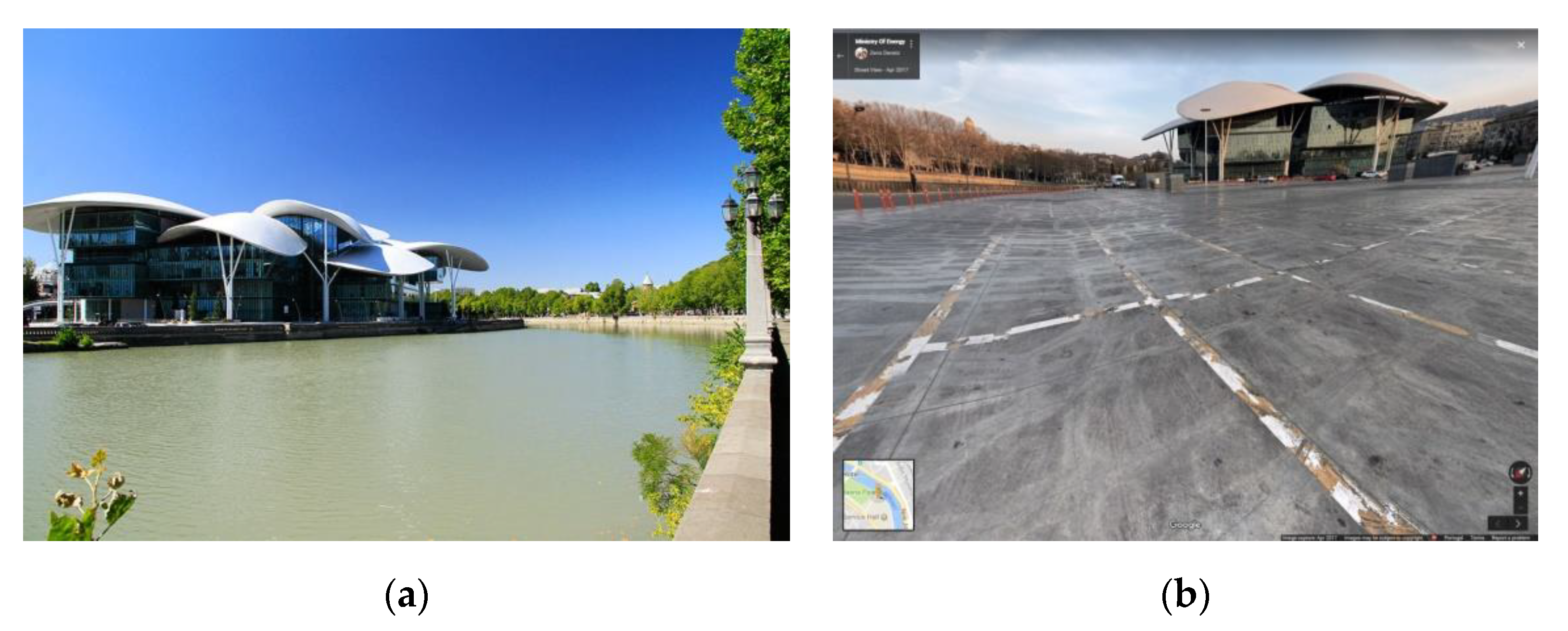
In Tbilisi, Georgia, the Kura river’s banks have been the object of a set of recent interventions. The riverfront is now punctuated by iconic (and costly) buildings and bridges. Reportedly, at least one famous foreign architect visited the site only after the project’s completion. These buildings ignore the scale of the valley and affect sightlines. Early phases of the intervention made little effort to establish a coherent network of public spaces along the riverfront and failed to address the river’s serious pollution issues. The barriers separating the river from the city, preventing direct access to the city center remain in place, and the banks are still dominated by highways and parking lots [11].
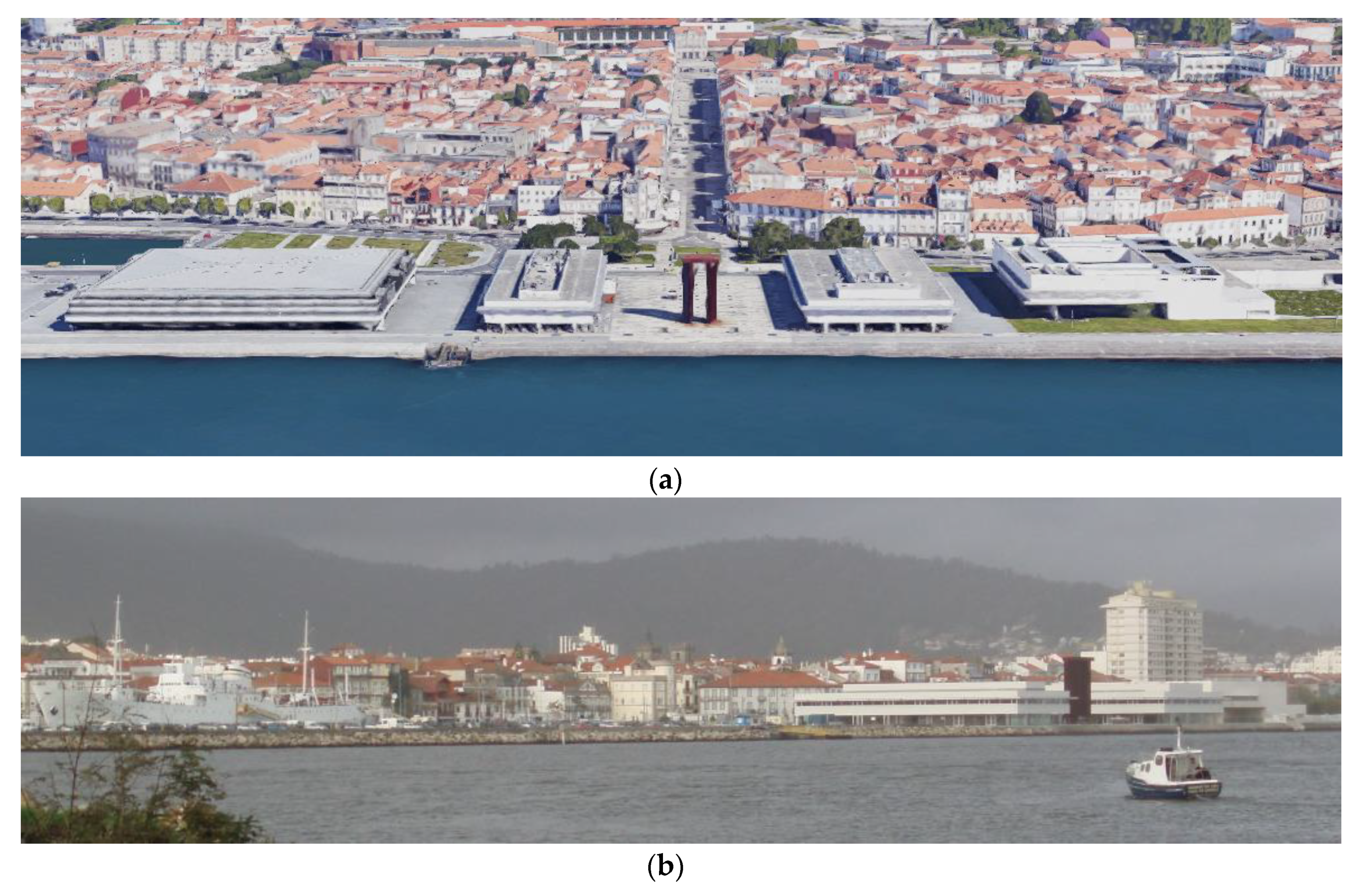
Viana do Castelo is an old city on the estuary of the Lima river, in northern Portugal. Dominated by the Santa Luzia Hill, the old medieval quarter used to front the river with characteristically narrow streets and compact blocks. An intervention from the early 2000s expanded public space along the river, on former dockyards, but also introduced three public buildings from prestigious Portuguese architects between the old town and the river. While the quality of the architectural designs is highly regarded, the placement of the buildings—lengthwise along the shore—and their sheer scale now blocks most views between the city center and the river (Figure 1).
The wrong place, then, may be summarized as a generalized lack of attention to the local context, in terms of scale, image and identity.
3.2. The Wrong “Budget”: Designs too Expensive and Out-of-Scale for the Context
As the Tbilisi project exemplifies, a typical consequence of the “wrong place” debacle is that the solution (especially when “imported” from a wealthy, larger urban center) often results in megalomaniac projects, where cost-benefit analysis has been eschewed or simply not well conducted. These interventions have the characteristic of being too costly to build and, perhaps more important, too costly to upkeep.
Project financing can include provisions for phased payments that kick in years after the project’s completion, and private developers are frequently granted tax exemptions that could contribute to unbalance public budgets.
Common offenders are riverfront parks with vast expanses of underutilized and overdesigned spaces, costly infrastructure to regulate water levels, (often oversized) bridges to nowhere and the aforementioned overpriced iconic building by “starchitects”. As with many large-scale enterprises, the true cost of the projects is prone to escalate during construction and, especially in some developing countries, overbilling could contribute to this.
The history of the contested ‘Garden Bridge’ in London is illustrative. Conceived as a planted pedestrian bridge (an over the water version of the Promenade Plantée in Paris and the later Highline in New York), the bridge would have been located where no bridge was needed (200 m from Waterloo Bridge and 300 m from Blackfriars Bridge). It was also controversial because of planned rules against picnics, music, groups larger than eight and sports—and because of Orwellian security cameras and cellphone tracking planned by the private project promoters [24]. Backed by then-Mayor Boris Johnson, the project was further tainted by irregularities in how the contracts were let to the design and construction firms [25], and the promoters’ plans to close the bridge for private functions at various times during the year. The project was ultimately canceled in 2017 after an audit demonstrated that the costs would far exceed the promised 185 M pounds [26], with 43 M pounds of public funds having already been wasted on the project.
Naturally, lack of transparency and accountability in the decision-making process is not an exclusive of waterfront redevelopment projects, but rather a more generalized issue with large-project management [27]. The public visibility (literal and figurative) of the urban riverfront does make the failure to engage the local community or the betrayal of its trust, more conspicuous.
While larger cities may be able to more readily accommodate cost overruns, smaller cities could be seriously affected if such a project becomes unwieldy. One way these projects tend to fail is that the escalating costs—sometimes even during the planning stages—make them progressively unpopular with the community, to the point where decision-makers reduce their scope, remove some elements or stages or abandon them altogether.
Even after construction, the maintenance budget may be shrunk or not keep up with rising costs. The ensuing decay of public spaces leads to a progressive degradation and, if unaddressed, may lead to the eventual abandonment.
One way or another, through being an unwanted burden on the local community, the project not only fails to serve the population, but may eventually even hinder the natural desirability of the urban riverfront. This can be correlated to the wrong choice of uses and crowds or the “wrong program” (see below).
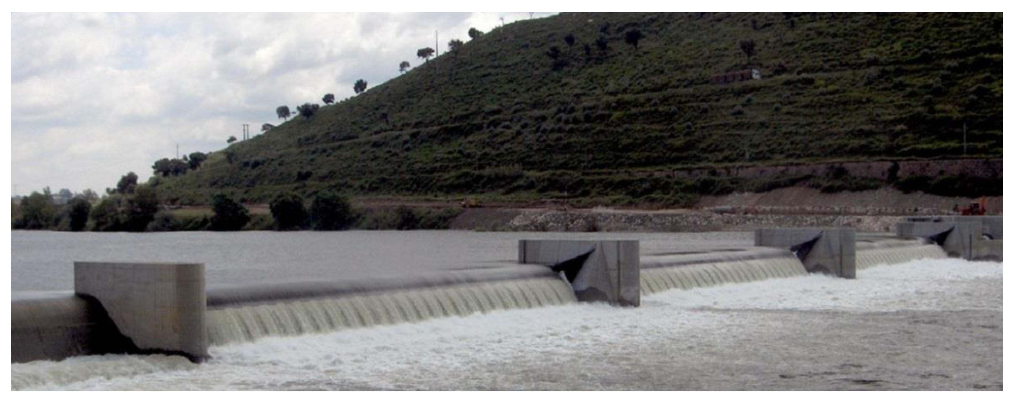
Abrantes, in Central Portugal, embarked on an ambitious project to create a shallow reservoir on the River Tagus, complemented by a large riverside park and an “urban beach”. The park itself cost about 5–6 M€ but required the construction of an inflatable weir–dam on the Tagus (Figure 2), costing another 10.5 M€ [28]. This is equivalent to half the municipality’s total budget for a whole year. The “Aquapolis” project now appears oversized for the city’s 18 thousand inhabitants, and the cost of operation of the inflatable weir that blocks the Tagus has led to successive maintenance issues [29], which have even affected the ability to lower the weir during the anadromous fish migration [30], as mandated by the national environmental agency.
Realistic cost-sharing arrangements should be enforced by the public agency or government charged with granting development permits. Failure to do so leads to an uneven distribution of costs among the public and private parties in waterfront developments, with the burden of public space improvement and ecological remediation falling disproportionately on the public entity, even where the new private development stands to benefit the most from the renewed waterfront stretch.
To sum up, the “wrong budget” is the failure to adequately evaluate and present the cost-benefit of the project, considering formulation, implementation, cost-sharing and maintenance.
3.3. The Wrong “Program”: Defining too Narrow a User Group
In many cases, selection of project uses, and layout were compromised by short-sighted decisions, such as the preference for those uses expected to provide the most short-term economic benefit, rather than striving to balance the different needs and opportunities a given site may provide. This may be especially evident when a large landowner, such as a port authority, strives for immediate yield from selling riverfront property, and chooses “lucrative” uses at the expense of public spaces, social facilities or affordable housing, producing a project that does not promote social diversity, ecological benefit or sustainable mobility.
Several authors have discussed at length the shift towards a commodification of the waterfront (an excellent review is provided by Avni [5]). Boland et al. [31] talk of strictly market-driven decisions where waterfronts are perceived as “new lifestyle centers”, focused on attracting “expensive apartments, creative, cultural and technological industries and commodified leisure and entertainment spaces”. According to Pinch and Munt [32], “It is an approach concerned with aesthecising the presence of water, of commodifying a river view (…). The waterspace is the multifunctional manner which we have suggested is necessary (…). Any policy that seeks to impose uniformity and sterility will ultimately fail.” Liverpool, while planning for European City of Culture 2008, rejected plans for a striking new building (“The Cloud”), reportedly because of uncertainty about what it would house [22].
Which leads us to a most relevant issue in waterfront interventions: a clear program is paramount. It is not only the design of the project that needs to be addressed, but, perhaps more important, the planned uses, the mix of these uses, and the public for these uses that needs to be clearly defined. By limiting the scope and objectives of the intervention to narrow and monofunctional solutions (forgoing opportunities to address multiple interests), the resilience of the intervention in face of shifting demands is reduced. Not catering to diverse crowds is the surest way to reduce the “vitality” of an urban area [33].
In Tbilisi, the iconic buildings are barren because they are not complemented by a coherent network of public spaces; some are surrounded by ungainly parking lots, as if the image of the building from afar would suffice in generating benefit for the city (Figure 3).
Canary Wharf’s slow start has been cited as an example of a project that was overly dependent on a single use, determined by a market-driven approach where local planning was deferred onto corporate developers [34]. The project’s main product at the time was office space, which rendered it exceptionally vulnerable to the shrinking demand for that specific use during the economic downturn. At the same time, this over-dependence in a single use minimized its early benefit for the city of London.
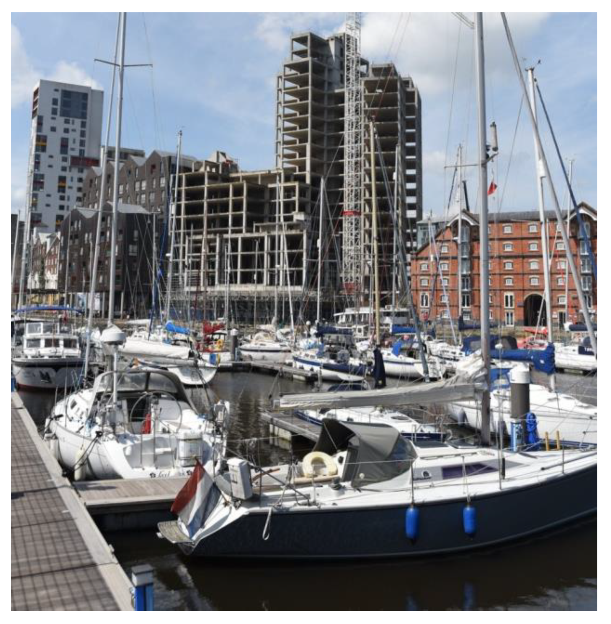
During the 2000s real-estate boom, waterfront residential developments along canals or former dockyards became a pervasive feature in British cities, often driven by “easy credit” (Figure 4). Market saturation and another economic downturn left entire developments unfinished for years (Figure 4). The inevitable bursting of this market bubble is brilliantly caricatured by Sue Townsend [35] through the tribulations of Adrian Mole.
The now-pervasive public–private partnership in waterfront redevelopment relies typically on flagship projects and aggressive marketing, based on consumption-oriented projects such as retail and tourism centers [6]. Krieger [16] highlights how providing a variety of services, including streets and public spaces, traditionally the responsibility of the public sector, has frequently been shifted to private enterprise. With it, often goes the right to determine how best to establish the connection between the city and river: The first waterfront row of construction provides a “razor-thin” edge of opportunity. Developers insist that “substantial height and density is needed to make construction and debt-service feasible,” and this often equates to a maximization of front-row construction, at the expense of broader viewsheds, visual connectivity between the city and its river or, at its worst, through the privatization of sections of the waterfront, sealing it off with physical and psychological barriers [36,37].
When cities fast-track interventions, they may “too quickly accept second-rate development proposals or engineer entire redevelopment plans around specific sites to enhance commercial real-estate or ‘jump-start’ waterfront renewal” [16], often precluding more conscientious, mixed-use development.
3.4. The Wrong “Time”: Poor Planning and Implementation, the Aura of a ‘Failed Project’
A bad “program” with a wrong mix of uses is often paired up with a lack of proper planning for the project’s implementation. Sometimes, projects fail to fulfill their potential not necessarily due to a “bad design” or one that is “too costly”, but simply because of bad project management. Although it is often hard to discern what exactly goes wrong with a project, inappropriate timing of the investments, insufficient public outreach or simply phasing the project inadequately may contribute to its failing.
As exemplified with the Canary Wharf project, a typical problem is the expectation that building everything at once, or a lot of a single use, will work. It often does not as, especially with larger projects, it makes them both vulnerable to economic downturns and to market saturation for that given use. Not involving the local population from early on tends to result in the community not being invested in the completion of the project. In larger projects, clear phasing of the construction is essential. Failing to do so may lead to less desirable uses being done upfront with resulting perception of a “failed project” or, paradoxically, to all the desirable plots and products being exhausted earlier on, impairing the capability to drive and finance further phases of the project. Once an intervention generates an aura of “failed project” it will be an uphill struggle to “clean the image” of the intervention in ensuing phases.
Seville’s 1992 Universal Exposition was held at the Isla de la Cartuja, an island on the Guadalquivir facing downtown Seville. After the Expo, the redevelopment of the area was marred by successive delays and missteps, stemming from the lack of a clear vision and planning for post-event transformation. The site remains largely abandoned to this day (Figure 5). The Seville Expo “was conceived as a State project and designed and executed by governmental bodies with no links to the city itself. (…) City planning by necessity had to take in the design of the exhibition ground on Cartuja Island (…) And for this reason, even today, the integration of the area into Seville’s urban fabric still presents difficulties” [38].
The mishaps of Seville informed the management of Lisbon’s World Exhibition of 1998, with the organizing committee and the municipality explicitly seeking to avoid the same pitfalls [39] and use the Expo as an opportunity to redevelop a derelict industrial area along the Tagus River northeast of the city center. The municipality and government cooperated in creating a two-stage urbanization plan, setting out from the onset the Expo-phase and the post-Expo creation of what came to be known as the Parque das Nações neighborhood.
Manifestly, both Expo92 and Expo98 responded to the same desire of city-marketing through flagship projects [40], but the latter was able to keep the momentum going through a more careful planning and timing of ensuing transformations.
Large-scale events, such as these exhibitions or large major sports events such as the Olympics or world cups, present especially complex post-event management issues. Yet, this same concern with adequate planning and phasing of construction should be considered in all types of waterfront interventions.
The London Docklands Development Commission purposefully avoided the creation of an Urban Masterplan, as it intended to leave individual developers more leeway in creating their own local plans. While these were considered more flexible and achieved rapid development, the LDDC was also criticized by observers as “having abandoned town planning” [41]. In less dynamic economic settings, such as Seville, this lack of a coherent strategy may prove fatal to projects. If the only thing driving them forward is private initiative, as interest dwindles, the project stalls.
Hamburg’s HafenCity is an example of a hybrid approach that retains a guiding vision (a “masterplan”) while openly resorting to public–private partnership in the plan’s implementation, and including provisions to readily adapt local plans in face of changing demands [42]. The “principles” that guide the project include several important aspects on how to run long-term, large-scale waterfront interventions [43]:
“The public authorities should play a coordinating role in policy interventions and project management and ensure quality of design and social equilibrium. The private sector should be involved from the start to ensure market knowledge and acceleration of development. (…) Public participation is an element of sustainability. (…) The community should be informed and involved in decisions and processes from the start. (…) Waterfronts are long-term projects. (…) The government should lend impetus at the political level to ensure that objectives are achieved independently of economic cycles or short-term interests. (…) Revitalization is an ongoing process. All master-planning should make use of a detailed analysis of the principal functions and meanings of the waterfront. Plans must be flexible, adaptable to change and include all disciplines.”
3.5. The Wrong “Color”: Missing Opportunities to Improve Ecological Function, Creating New Environmental Impacts
In many cities, encroachment of floodplains with urban development led to a stance of flood defense that posited that city and river were in a fight for territory, and the perception that the measure of success was exclusively in our ability to keep the flooding river “at bay”, behind levees or within concrete channels [1]. Shifting paradigms now force us to confront this ambition with the environmental consequences of these “gray” solutions [2].
Nowadays, there is a growing understanding that floods may be managed, through the implementation of broader strategies at the watershed level and the incorporation of local “green” flood mitigation solutions, such as the creation of detention basins or the provision, where space is available, of widened channels or terraces and floodplains, to accommodate the flooding river without compromising urban uses and infrastructure. “To be effective, urban stream restoration efforts must be integrated within broader catchment management strategies” [44].
There is also a growing realization that these “green” infrastructures are often compatible with desirable urban uses, such as parks, which may be used extensively by the local population when the river is not at its flood stage (Figure 6). Fortunately, there appears to be an increasing understanding that ecological restoration is often a possibility, especially when considered along a spectrum of solutions, dependent on the available space, degree of alteration and, naturally, budget [45,46]. These solutions run a gamut from simply providing more trees and shade along armored banks, to creating narrow strips of riparian vegetation along walkable banks, to recreating stepped terraces doubling as narrow flood plains, to eventually restoring natural floodplains and possibly even giving the river an “espace de liberté” within which its channel can migrate, erode and deposit sediment, restoring lateral and vertical connectivity [7].
Preserving and restoring natural processes can animate urban riverfronts, imbuing a wildness that greatly enhances the restorative properties of public space along the river. Along the Isar in Munich, naturally deposited gravel bars have a wild character and have proved highly popular with local residents in warm weather months, and which serve as habitat in winter months (Figure 6).
Brownfield sites along the riverfront have been too readily misrepresented as empty wastelands, when often they provide, even in their derelict condition, important ecological services [47]. The construction of London’s MI5 headquarters resulted in a five-foot encroachment onto the Thames foreshore, changing local hydrology and affecting migratory bird habitat. “The development also prevents access beneath Vauxhall Bridge and therefore prevents the extension of the Thames Path at this location”, affecting social as well as ecological connectivity [32].
Especially in regions with high variability of rainfall and flow patterns, many cities have built weirs or dams to create “mirror lakes” in urban sections of rivers [48,49]. In the past this was done with little concern for the impairment of local habitat and longitudinal connectivity. In some countries with stronger environmental regulations, some weirs and dams are now managed so as to allow anadromous fish migrations, through seasonal opening of sluices, regulation of water-levels or the inclusion of fish passages. However, these solutions may be challenging to manage and prone to failure.
In Ponte de Sôr, central Portugal, a recent riverfront park relies on the dammed waters of the Sôr to keep the water levels artificially high. However, inadequate management of the sluice gates at the weir–dam blocks the upstream movement of migratory Iberian Nase (Pseudochondrostoma polylepis) to their spawning grounds.
The complex Abrantes inflatable weir–dam on the Tagus, discussed above, has experienced continued problems, including at least one documented fish-kill [30]. The weir is owned and operated by the local municipality, but such local governments are unlikely to have either the economic or technical resources to operate such large-scale infrastructure on a major river.
It is often the case that the rash and opportunistic decisions made on the urban waterfront have long-term and costly, economic and environmental impacts. Decisions about urban waterfront projects are seldom made with an integrated view of their positive and negative impacts over the larger river system. The impacts on the catchment, upstream and downstream, are rarely understood or fully considered. If they were, it is less likely that we would see so many decisions to disrupt longitudinal connectivity, permit floodplain encroachment and neglect flow and sediment management.
Over-designed projects with formal elements imported from other climates and settings may also fail because they are not adapted to the river’s geomorphic processes. In Houston, the highly designed Buffalo Bayou Park suffered extensive erosion and deposition of a foul mix of silt, sewage and solid waste during Hurricane Harvey in 2017. Houston lies in the ‘flash-flood alley’ of Texas, exposed to floods not only from hurricanes from the Gulf of Mexico, but also intense local convective systems, so a more geomorphically appropriate approach would be to leave a wide natural corridor to absorb the periodic floods, their high energy and high sediment loads.
The same copycat element that was described in “the wrong place” can also result in the importation of foreign models of riverfront restoration or the quest to recreate the same landscape choices in completely unsuited contexts [49]. As Wolman [50] observed, “the appropriate combination of aesthetics, economics and physical limitations is not a constant, but must vary from city to city and from river to river”.
The most extreme expression of this phenomenon is the construction of entirely artificial water-features the size of an actual river segment, in what could be termed as a “river-in-name-only”. Sometimes, these projects try to recuperate long-lost rivers or creeks, by “daylighting” them, but then preserving them fully within a system of canals with artificial water sources, disconnected from a river catchment, as is the case of the otherwise very successful Cheonggyecheon in Seoul, Korea.
Especially in the developing world, a common mistake is to approach urban waterfront interventions as essentially cosmetic. The Sabarmati River Development Project (SRDP), in Ahmedabad, India, is an example of how narrow-minded and outdated some projects in the developing world can be [51]:
“In terms of precedents, the SRDP explicitly draws on existing riverfront projects, mostly from western countries. In particular it uses the examples of the Thames in London to illustrate how large-scale engineering and embankment construction can create a public riverfront. (…) But given the ecological setting of the monsoon fed Sabarmati and its highly variable discharge, the one component which is in short supply in this region is the water. To overcome this shortcoming, the project draws water from an irrigation canal constructed as part of an inter-basin water transfer project [and] a barrage just downstream of the city is used to regulate the outflow of water. (…) The visual aesthetic the project proposes is also one which removes any traces of a riverine ecosystem and instead emphasizes stark modernist exposed concrete embankments, manicured lawns and shrubs and regimented plantation of trees.”
Another common pitfall in these projects is ignoring the correlation between improving water quality and the “revival” of urban waterfronts in the later part of the 20th century, especially in Western Europe and North America. Tbilisi’s intervention, mentioned before, was not accompanied by an effort to clean Kura river’s waters. The current poor water quality will preclude opportunities for recreation in the river itself [11]. Persistently poor water quality is indeed a major obstacle to urban river restoration in the Global South [13].
The disturbance of natural systems for urban benefit should be very carefully considered, as should the opportunity for habitat restoration, not only for the direct ecological benefit, but equally for the indirect co-benefits for local communities [52], in the creation of urban parks or reserves where the river’s natural functions are still patent. “The city’s approach to river corridor development must play its part in improving the ecological health of rivers which in turn is likely to be beneficial to the city” [2].
Projects that, despite all warning to the contrary, still embrace fully “gray” solutions, reinforcing banks against floods, encroaching the floodplain, failing to consider their ecological impacts or failing to incorporate any compatible elements of habitat restoration or integrated flood management (“green” solutions) where feasible, can be blamed of an anachronistic choice of the “wrong color”.
4. Discussion: Getting it Right
It is not unusual for a really bad project to “get it all wrong”; a poorly designed riverfront intervention typically fails on several levels: a bad program, with the wrong budget and timing, no concern for local needs or context, results in an unattractive and costly intervention, with reduced to no social or environmental benefit.
When deciding what to do with our urban riverfronts, learning from past mistakes is as important (or perhaps more) as taking away what worked. Oftentimes, the iconic building that “saved” a given post-industrial city is unrepeatable, as the context and opportunity were very specific to that one city; yet, our ability to recognize what did not work elsewhere, the causes for failure, provide us with the clues on how to improve our own projects.
Lisbon clearly benefited from the disappointing experience of Seville six years earlier, and the growth pains of Canary Wharf alerted a few to the risks of over-dependence on a single land use. Knowing how to avoid the wrong place, budget, program, time and color may, paradoxically, provides us with a useful framework on how to create a better, successful, intervention, which we have compiled in the form of the five “wrongs” in waterfront redevelopment (Table 1).
Learning from past mistakes helps reveal those aspects that tend to be neglected, such as social equality or ecological and long-term economic sustainability. Emphasizing them may be the first step in adequately addressing them, in a timely, inclusive and balanced manner.
Of these aspects that tend to be inadequately addressed, we would highlight the difficulty in correctly “reading”—and respecting—the scale of the waterfront. Each case is unique, although comparable settings can be used for reference. When waterfront intervention was a local “business” and less of a mass-produced global phenomenon, a city would decide how best to develop its waterfront. Sometimes this produced great results, often with mistakes, but always with the local context in mind. The most memorable waterfronts are typically those that look, feel and work “just right”; this has a lot to do with being at exactly the “right scale” to the river, its valley and the urban development laid upon it, tailor-made to “fit” its site.
In addition to scale, the other major consideration should be the definition of appropriate uses and a mix of functions that work for a diverse crowd and provide multiple benefits, including good flood management performance and the restoration of the rivers’ natural connectivity. That this diversity could greatly contribute to the success and vitality of the waterfront is by no means a recent finding, but it is still often disregarded in strictly market-driven interventions. In 1961, Jane Jacobs [33] wrote:
“People do not use open space just because it is there [...] [attractive] parks differ much within themselves from part to part, and they also receive differing influences from different parts of their cities which they touch (…) The first, primary uses, are those which, in themselves, bring people to a specific place because they are anchorages. (…) Secondary diversity is the name for the enterprises that grow in response to the presence of primary uses, to serve the people the primary uses draw.”
Successful urban riverfront projects characteristically improve social connectivity along three dimensions [7]: lateral, longitudinal and sometimes vertical (Figure 7).
Lateral connectivity is probably the priority, to allow residents to access their riverbank. Many cities are cut off from their riverfronts by major roadways or railroads that make pedestrian access impossible or dangerous. Flood control levees may also visually and physically cut off city from river, as is the case with most of New Orleans and the Mississippi River. Overcoming these barriers is a major challenge, but recent changes, such as the relocation of industry or port infrastructures has opened new opportunities for reconnecting cities with their rivers. It is thus particularly tragic when riverfront revival projects fail to restore this connectivity. Viana do Castelo’s recent interventions worsened visual connectivity between the city center and the river, whereas costly waterfront interventions in Tbilisi have failed to remove most barriers blocking access to the riverfront or address the poor water quality.
Providing for longitudinal movement along the banks greatly increases the range of users on a riverfront, encouraging cyclists, runners, pedestrians, strollers and wheelchair users. Some urban rivers with long continuous trails, such as the American River in Sacramento, California, are already important commuter routes. Simply taking a run along a river can require all three forms of connectivity: lateral to get to the edge of the river, vertical to descend down the bank and longitudinal to have a worthwhile run. Clean waters, functioning ecosystems—and the ability to access glimpses of “nature in the city”—provided by riparian corridors and floodplains can greatly increase the attractiveness of urban riverfronts, as is the case in Munich.
5. Conclusions
It may be hard to figure out exactly what will work in any given waterfront. The challenges, competing uses and uncertainties can stall the thought-process and adequate balancing of requirements and available resources. It can also preclude certain (and potentially better) solutions in face of more obvious, easier or more profitable options.
It is our understanding that, while knowing exactly what to do is often daunting, knowing exactly what not to do may be more straightforward. Very often urban riverfront interventions fail the same way others have failed before them: they are too large, too monotonous, too costly or fail to address existing needs. Learning from the mistakes of others can prove invaluable and help structure the decision-making process in defining the design options.
A poorly designed riverfront intervention typically fails on several levels: a bad program, with the wrong budget and timing, no concern for local needs or context, results in an unattractive and costly intervention, with little to no social or environmental benefit. Urban riverfront interventions may be improved in the future if, when deciding what to do with our urban riverfronts, we learn from past mistakes. This may be as important (or perhaps more) as observing or attempting to replicate, what worked.
To get urban riverfront interventions right, we should acknowledge the local context, the morphology of the river valley, the time and budget a set of solutions entail and select uses and functions that work for a diverse crowd and provide multiple benefits, including good flood management performance and the restoration of the rivers’ natural connectivity. To the extent these fit their location, they are more likely to succeed.
Author Contributions
Conceptualization, P.J.P. and G.M.K.; methodology, P.J.P. and G.M.K.; formal analysis, P.J.P. and G.M.K.; investigation, P.J.P. and G.M.K.; data curation, P.J.P.; writing—original draft preparation, P.J.P. and G.M.K.; writing—review and editing, P.J.P. and G.M.K.; visualization, P.J.P.; supervision, P.J.P. and G.M.K.; project administration, P.J.P. and G.M.K.; funding acquisition, P.J.P. and G.M.K. All authors have read and agreed to the published version of the manuscript.
Funding
Partially funded by the EUR H2O’Lyon (ANR-17-EURE-0018) of Université de Lyon (UdL), within the program “Investissements d’Avenir” operated by the French National Research Agency (ANR) and by project MetroGov3C of the Portuguese Foundation for Science and Technology (FCT– PTDC/GES-URB/30453/2017).
Acknowledgments
This work has been supported by the EUR H2O’Lyon (ANR-17-EURE-0018) of Université de Lyon (UdL), within the program “Investissements d’Avenir” operated by the French National Research Agency (ANR). The authors also gratefully acknowledge the Collegium de Lyon—Institut des Etudes Avancées de l’Université de Lyon, the EURIAS Fellowship Programme and the European Commission (Marie-Sklodowska-Curie Actions-COFUND Programme-FP7) for support of manuscript preparation by Kondolf and funding for the authors’ attendance at the IS River 2018 conference. Pinto benefited from funding by the Portuguese Foundation for Science and Technology, while working for the project MetroGov3C (FCT–PTDC/GES-URB/30,453/2017) during preparation of the manuscript.
Conflicts of Interest
The authors declare no conflict of interest.
References
- Mann, R. Rivers in the City; David & Charles: Newton Abbott, UK, 1973. [Google Scholar]
- Lerner, D.N.; Holt, A. How should we manage urban river corridors? Procedia Environ. Sci. 2012, 13, 721–729. [Google Scholar] [CrossRef] [Green Version]
- Goss, J. Disquiet on the waterfront: Reflections on nostalgia and utopia in the urban archetypes of festival marketplaces. Urban Geogr. 1996, 17, 221–247. [Google Scholar] [CrossRef]
- Brownill, S. Just add water: Waterfront regeneration as a global phenomenon. In The Routledge Companion to Urban Regeneration; Routledge: Abingdon-on-Thames, UK, 2013; pp. 65–75. [Google Scholar]
- Avni, N. Planning a Just City: Examining Waterfront Redevelopment Projects from a Social Justice Perspective. Ph.D. Thesis, McGill University, Montreal, QC, Canada, 2017. [Google Scholar]
- Sairinen, R.; Kumpulainen, S. Assessing social impacts in urban waterfront regeneration. Environ. Impact Assess. Rev. 2006, 26, 120–135. [Google Scholar] [CrossRef]
- Kondolf, G.M.; Pinto, P.J. The social connectivity of urban rivers. Geomorphology 2017, 277, 182–196. [Google Scholar] [CrossRef]
- Kondolf, G.M.; Podolak, K.; Gaffney, A. (Eds.) From High Rise to Coast: Revitalizing Ribeira da Barcarena; Water Resources Center Report No.210, and Report WP 2010-01; Institute of Urban and Regional Development, and Institute of European Studies Publication 1102, University of California: Berkeley, CA, USA, 2010; Available online: https://iurd.berkeley.edu/wp/2010-01.pdf (accessed on 14 May 2020).
- Kondolf, G.M.; Mozingo, L.; Marzion, R.; Balakrishnan, K.; Gohar, A. Connecting Cairo to the Nile: Renewing Life and Heritage on the River; Institute of Urban and Regional Development Working Paper No. 2011-007; University of California: Berkeley, CA, USA, 2011; Available online: https://iurd.berkeley.edu/wp/2011-06.pdf (accessed on 14 May 2020).
- Pinto, P.; Podolak, K.; Kondolf, G.M. Water and Environment in Portugal: The Dammed and the Reborn. In The Portuguese Republic at a Hundred; Herr, R., Pinto, A.C., Eds.; University of California Press: Berkeley, CA, USA, 2011. [Google Scholar]
- Gonçalves, J.; Asanidze, D.; Pinto, P. The Riverfront as a Mirror: The Case of the Transformations in Post-Soviet Cities. New Water Policy Pract. 2016, 2, 21–35. [Google Scholar] [CrossRef]
- Pinto, P.J.; Wong, R.; Curley, J.; Johnson, R.; Xu, L.; Materman, L.; Avalon, M.; Saraiva, G.; Serra-Llobet, A.; Kondolf, G.M. Managing Floods in Mediterranean-Climate Urban Catchments: Experiences in the San Francisco Bay Area (CA, USA) and the Tagus Estuary (Portugal). In Managing Flood Risk: Innovative Approaches from Big Floodplain Rivers and Urban Streams; Serra-Llobet, A., Kondolf, G.M., Schaefer, K., Nicholson, S., Eds.; Palgrave Macmillan: London, UK, 2018; p. 162. [Google Scholar]
- Wantzen, K.M.; Alves, C.B.M.; Badiane, S.D.; Bala, R.; Blettler, M.; Callisto, M.; Cao, Y.; Kolb, M.; Kondolf, G.M.; Leite, M.F.; et al. Urban Stream and Wetland Restoration in the Global South—A DPSIR Analysis. Sustainability 2019, 11, 4975. [Google Scholar]
- Gohar, A.; Kondolf, G.M. Bridges over the Nile: Transportation corridors transformed into public spaces. J. Public Space 2020, 4, 5–20. [Google Scholar] [CrossRef] [Green Version]
- Harvey, D. The Art of Rent: Globalization, Monopoly and the Commodification of Culture. Soc. Regist. 2002, 38, 93–110. [Google Scholar]
- Krieger, A. Reflections on the Boston waterfront. In Waterfronts in Post-Industrial Cities; Marshall, R., Ed.; Taylor & Francis: Abingdon-on-Thames, UK, 2001; p. 177. [Google Scholar]
- Ockman, J. New politics of the spectacle: “Bilbao” and the global imagination. In Architecture and Tourism: Perception, Performance, and Place; Berg: New York, NY, USA, 2004; pp. 227–240. [Google Scholar]
- Gomez, M.V.; Gonzalez, S. A Reply to Beatriz Plaza’s ‘The Guggenheim-Bilbao Museum Effect’. Int. J. Urban Reg. Res. 2001, 25. Available online: http://scholars-on-bilbao.info/fichas/6GomezGonzIJURR2001.pdf (accessed on 14 May 2020). [CrossRef] [Green Version]
- Santos, P.M. The Tourism Constellation: Urban Tourism and the Globalized Circuits of Commodified Selves. In Globalization and Metropolization: Perspectives in Europe’s West Coast; Santos, P.M., Seixas, P.C., Eds.; Berkeley Public Policy Press, Institute of Governmental Studies: Berkeley, CA, USA, 2014; pp. 109–132. [Google Scholar]
- Michael, C. The Bilbao Effect: Is ‘Starchitecture’ all it’s cracked up to be? A History of cities in 50 buildings. The Guardian. 27–30 April 2015. Available online: https://www.theguardian.com/cities/2015/apr/30/bilbao-effect-gehry-guggenheim-history-cities-50-buildings (accessed on 14 May 2020).
- Ellis, A. Can culture save downtown. GIA Reader 2006, 17. Available online: https://www.giarts.org/article/can-culture-save-downtown (accessed on 14 May 2020).
- Evans, G.; Shaw, P. Literature Review: Culture and Regeneration. Arts Res. Dig. 2006, 37. Available online: http://media.ifacca.org/files/RegenerationLitReview.pdf (accessed on 14 May 2020).
- Chang, T.C.; Huang, S. Reclaiming the city: Waterfront development in Singapore. Urban Stud. 2011, 48, 2085–2100. [Google Scholar] [CrossRef]
- Walker, P. London Garden Bridge users to have mobile phone signals tracked. The Guardian. 6 November 2015. Available online: https://www.theguardian.com/uk-news/2015/nov/06/garden-bridge-mobile-phone-signals-tracking-london (accessed on 14 May 2020).
- Townsend, M. Met police urged to investigate Garden Bridge contracts. The Guardian. 10 October 2015. Available online: https://www.theguardian.com/politics/2015/oct/10/garden-bridge-metropolitan-police-urged-investigate-procurement-deals (accessed on 14 May 2020).
- O’Sullivan, F. How London fell out of love with the ‘Garden Bridge’. CityLab 2015. Available online: https://www.citylab.com/design/2015/11/how-london-fell-out-of-love-with-the-garden-bridge/415131/ (accessed on 14 May 2020).
- Frick, K.T. A Sure Bet: Megaprojects–Not on Time and Not on Budget; Op-ed published online by Alexandrine Press: Abingdon, UK, 2017; Available online: https://www.alexandrinepress.co.uk/Oakland_Bay_Bridge (accessed on 14 May 2020).
- Fonseca, M.R. Dizem que o novo açude “é uma espécie de mar de Abrantes”. Diário de Notícias. 16 June 2007. Available online: https://www.dn.pt/arquivo/2007/interior/dizem-que-o-novo-acude-e-uma-especie-de-mar-de-abrantes-659526.html (accessed on 14 May 2020).
- Lusa Obras de reparação a decorrer no açude insuflável de Abrantes. Sapo 24. 18 August 2018. Available online: https://24.sapo.pt/atualidade/artigos/obras-de-reparacao-a-decorrer-no-acude-insuflavel-de-abrantes (accessed on 14 May 2020).
- Baptista, J. Açude de 10,5 milhões de euros é armadilha mortal para peixes no Tejo. Diário de Notícias. 14 April 2015. Available online: https://www.dn.pt/portugal/interior/acude-de-105-milhoes-de-euros-e-armadilha-mortal-para-peixes-no-tejo-4509179.html (accessed on 14 May 2020).
- Boland, P.; Bronte, J.; Muir, J. On the waterfront: Neoliberal urbanism and the politics of public benefit. Cities 2017, 61, 117–127. [Google Scholar] [CrossRef] [Green Version]
- Pinch, P.; Munt, I. Blue belts: An agenda for ‘waterspace’ planning in the UK. Plan. Pract. Res. 2002, 17, 159–174. [Google Scholar] [CrossRef]
- Jacobs, J. The Death and Life of Great American Cities; Random House: New York, NY, USA, 1961. [Google Scholar]
- Mah, A. Port Cities and Global Legacies: Urban Identity, Waterfront Work, and Radicalism; Springer: New York, NY, USA, 2014. [Google Scholar]
- Townsend, S. Adrian Mole and the Weapons of Mass Destruction; Michael Joseph: London, UK, 2004. [Google Scholar]
- Breen, A.; Rigby, D. The New Waterfront: A Worldwide Urban Success Story; Thames and Hudson: London, UK, 1996; pp. 5–9. [Google Scholar]
- Low, S. How Private Interests Take Over Public Space: Zoning, Taxes, and Incorporation of Gated Communities. In The Politics of Public Space; Low, S., Smith, N., Eds.; Routledge: Abingdon-on-Thames, UK, 2006; pp. 82–83. [Google Scholar]
- Castillo-Manzano, J.I.; López-Valpuesta, L.; Marchena-Goméz, M. Seville: A city with two souls. Cities 2015, 42, 142–151. [Google Scholar] [CrossRef]
- Pereira, A.P.F. O Parque das Nações em Lisboa: Uma Montra da Metrópole à Beira-Tejo. Ph.D. Thesis, FCSH-University of Lisbon, Lisbon, Portugal, 2013. Available online: https://run.unl.pt/bitstream/10362/9761/1/O%20Parque%20das%20Na%C3%A7%C3%B5es%20em%20Lisboa%20uma%20montra%20da%20metr%C3%B3pole%20%C3%A0%20beira%20Tejo%20Maio%202013.pdf (accessed on 14 May 2020).
- Carrière, J.-P.; Demazière, C. Urban Planning and Flagship Development Projects: Lessons from EXPO 98, Lisbon. Plan. Pract. Res. 2002, 17, 69–79. [Google Scholar] [CrossRef]
- Shaw, B. History at the water’s edge. Waterfronts in post-industrial cities. In Waterfronts in Post-Industrial Cities; Marshal, R., Ed.; Taylor & Francis: Abingdon-on-Thames, UK, 2001; pp. 160–172. [Google Scholar]
- Schubert, D. Waterfront transformations and city/port interface areas in Hamburg. Dimens. Empres. 2015, 13, 9–20, Print version ISSN 1692-8563. Available online: http://www.scielo.org.co/scielo.php?pid=S1692-85632015000100001&script=sci_arttext&tlng=en (accessed on 14 May 2020). [CrossRef] [Green Version]
- Sepe, M. Urban history and cultural resources in urban regeneration: A case of creative waterfront renewal. Plan. Perspect. 2013, 28, 595–613. [Google Scholar] [CrossRef]
- Bernhardt, E.S.; Palmer, M.A. Restoring streams in an urbanizing world. Freshw. Biol. 2007, 52, 738–751. [Google Scholar] [CrossRef]
- Findlay, S.J.; Taylor, M.P. Why rehabilitate urban river systems? Area 2006, 38, 312–325. [Google Scholar] [CrossRef]
- Moggridge, H.L.; Hill, M.J.; Wood, P.J. Urban Aquatic Ecosystems: The good, the bad and the ugly. Fundam. Appl. Limnol. 2014, 185, 1–6. [Google Scholar] [CrossRef] [Green Version]
- Collins, T.; Savage, K. Brownfields as places: A case study in learning to see assets as well as liabilities, opportunities as well as constraints. Public Works Manag. Policy 1998, 2, 210–219. [Google Scholar] [CrossRef]
- Pueyo, Á.; Climent, E.; Ollero, A.; Pellicer, F.; Peña, J.L.; Sebastián, M. L’interaction entre Saragosse et ses cours d’eau: Évolution, conflits et perspectives. Sud-Ouest Eur. 2018, 44, 7–23. [Google Scholar] [CrossRef]
- Shi, S.; Kondolf, G.M.; Li, D. Urban River Transformation and the Landscape Garden City Movement in China. Sustainability 2018, 10, 4103. [Google Scholar] [CrossRef] [Green Version]
- Wolman, M.G. A cycle of sedimentation and erosion in urban river channels. Geogr. Ann. Ser. A Phys. Geogr. 1967, 49, 385–395. [Google Scholar] [CrossRef]
- Balakrishnan, K. Sabarmati Riverfront Development: An Exercise in ‘High-Modernism’. In Proceedings of the ISRivers Conference, Lyon, France, 4–8 June 2018; Available online: http://www.graie.org/ISRivers/docs/papers/2018/23D33-284BAL.pdf (accessed on 14 May 2020).
- Kondolf, G.M.; Yang, C.-N. Planning river restoration projects: Social and cultural dimensions. In River Restoration: Managing the Uncertainty in Restoring Physical Habitat; Sear, D., Darby, S., Eds.; Wiley: Chichester, UK, 2008; pp. 43–60. [Google Scholar]
Figure 1.
Viana do Castelo, Portugal: three recent public buildings block views of the old town from the Lima riverbanks. (a) Perspective showing how three large new buildings by famous Portuguese architects partially cut the old town off from the water (image: Google; (b) view of Viana from the Lima River estuary, showing the dominance of large new buildings on the waterfront. The earlier tall block visible on the background, dating back to the 1980 s, is pending demolition (image credits: Pedro Pinto).

Figure 2.
Abrantes’ inflatable weir–dam (image: TPF Consultores, used by permission).

Figure 3.
Tbilisi’s new public services building: striking architecture, yet surrounded by new surface parking on the waterfront (image: (a) Levan Gokadze; (b) Zeno Davatz/Google).
Figure 3.
Tbilisi’s new public services building: striking architecture, yet surrounded by new surface parking on the waterfront (image: (a) Levan Gokadze; (b) Zeno Davatz/Google).

Figure 4.
A large building left unfinished since 2010 on Ipswich’s Regatta Quay, along the Orwell river. Relying on limited uses and basing the project’s success on the premise of high-return renders it vulnerable to boom-and-bust economic cycles (image credits: Angela Sharpe/Ipswich Star, used by permission).

Figure 5.
Seville, Spain: large areas of the 1992 Universal Exhibition site remain abandoned, despite their location next to the city’s center (image credits: Jesus Coromina, used by permission).
Figure 5.
Seville, Spain: large areas of the 1992 Universal Exhibition site remain abandoned, despite their location next to the city’s center (image credits: Jesus Coromina, used by permission).

Figure 6.
Banks of the restored Isar River in Munich are heavily used for leisure and recreation (image credits: G.M. Kondolf, July 2013).
Figure 6.
Banks of the restored Isar River in Munich are heavily used for leisure and recreation (image credits: G.M. Kondolf, July 2013).

Figure 7.
Social connectivity can be improved along three dimensions: Access to the waterfront and across the river (lateral), along the banks and the river itself (longitudinal) and down and into, the water itself (vertical) (reproduced from Kondolf and Pinto [7]).
Figure 7.
Social connectivity can be improved along three dimensions: Access to the waterfront and across the river (lateral), along the banks and the river itself (longitudinal) and down and into, the water itself (vertical) (reproduced from Kondolf and Pinto [7]).


Table 1.
Five “wrongs” in waterfront redevelopment. “Getting it right” could be informed by learning from past mistakes and avoiding these pitfalls.
Table 1.
Five “wrongs” in waterfront redevelopment. “Getting it right” could be informed by learning from past mistakes and avoiding these pitfalls.
| The wrong “place”: not accounting for location and scale | “Copycat” interventions, copying what was deemed as successful elsewhere |
| No regard for local identity/architecture/urban layout | |
| No adaptation to the morphology and scale of the valley and river | |
| Projects too big for location or for the city’s size | |
| Non-descript replicas, with issues of scale, connectivity, or detached from local reality | |
| The wrong “budget”: designs too expensive and out-of-scale for the context | Megalomaniac projects/“starchitects” & “Guggenheims” |
| Underutilized and/or overdesigned spaces | |
| High maintenance costs | |
| Regulated water levels through expensive damming, canals, or bypasses | |
| Lack of public consultation & accountability and/or unchecked expenditures | |
| The wrong “program”: defining too narrow a user group | Betting only on the most profitable use of the day/no redundancy: if market stalls, nothing gets done |
| Avoidance of non-lucrative uses/failure to address pertinent social needs/exclusion of some potential users/forced evictions or restrictions on public access | |
| Inadequate contributions to project costs by private parties benefiting from public investments | |
| Reduced investment on connectivity/transport to and from the area | |
| Single-purpose areas, leading to monotonous and unattractive public spaces | |
| The wrong “time”: poor planning and implementation, the aura of a ‘failed project’ | Bad timing and/or no clear phasing of investments |
| Building everything at once, or building the most costly and risky elements up-front | |
| Lack of public outreach/engagement with local population | |
| Where private investment is expected, no clear strategy on how to attract it | |
| Creating the image of “failed project”, which hinders further investment | |
| The wrong “color”: missing opportunities to improve ecological function, creating new environmental impacts | Flood “defense” through over-engineered banks/no provision for floodplain restoration or, at the very least, a riparian corridor along part of the banks |
| In brownfield sites where space is available, hard surfaces take over most of the site, where green areas with passive flood detention could be incorporated | |
| Unsuited to local climate/hydrology | |
| No integrated view of connectivity upstream and downstream, including fish migration and sediment transport | |
| No provision to improve river ecosystems and water quality and/or make them accessible/visible to local populations |
© 2020 by the authors. Licensee MDPI, Basel, Switzerland. This article is an open access article distributed under the terms and conditions of the Creative Commons Attribution (CC BY) license (http://creativecommons.org/licenses/by/4.0/).
Share and Cite
MDPI and ACS Style
Pinto, P.J.; Kondolf, G.M. The Fit of Urban Waterfront Interventions: Matters of Size, Money and Function. Sustainability 2020, 12, 4079. https://doi.org/10.3390/su12104079
AMA Style
Pinto PJ, Kondolf GM. The Fit of Urban Waterfront Interventions: Matters of Size, Money and Function. Sustainability. 2020; 12(10):4079. https://doi.org/10.3390/su12104079
Chicago/Turabian StylePinto, Pedro Janela, and G. Mathias Kondolf. 2020. "The Fit of Urban Waterfront Interventions: Matters of Size, Money and Function" Sustainability 12, no. 10: 4079. https://doi.org/10.3390/su12104079
Note that from the first issue of 2016, this journal uses article numbers instead of page numbers. See further details here.