Walking Access to Public Transportation Stops for City Residents. A Comparison of Methods


Institute of Socio-Economic Geography and Spatial Management, University of Szczecin, Mickiewicza 18 Street, 70–383 Szczecin, Poland
*
Author to whom correspondence should be addressed.
Sustainability 2019, 11(14), 3758; https://doi.org/10.3390/su11143758
Submission received: 14 May 2019
/
Revised: 3 July 2019
/
Accepted: 5 July 2019
/
Published: 10 July 2019
(This article belongs to the Special Issue Accessibility and Transportation Equity)
Abstract
:Public transportation in cities is crucial for their sustainable development. The attractiveness of public transport for city residents depends largely on whether they are able to access the nearest stop on foot. The actual time of walking to the nearest stop and the distance covered can be measured using the band method or the circular buffer method. The accuracy of the two methods was compared for the city of Szczecin and one of its residential areas, Pomorzany (ca. 20,000 inhabitants, ca. 7 km2 area). The city provides public tram and bus transportation and has 90 km of streets and pedestrian paths. As shown by the results, the band method proved more accurate in measuring public transport stop accessibility. It showed 53.8% of the stops to be highly accessible, whereas 37.8%, 7.8%, and 0.5% were classified as moderately accessible, poorly accessible, and inaccessible, respectively; the latter would be hardly expected to be used by pedestrians in the Pomorzany neighborhood. The band method allowed also to indicate potential location of a new bus stop which would significantly improve accessibility of public transportation to residents of a housing estate (3000 inhabitants) in the area.
1. Introduction
Economic development and societal progress generate new expectations with regard to mobility, environmental protection, and quality of life [1]. A more sustainable urban development is one of the greatest challenges of modern times. Most big cities, especially the megacities, strive to function and develop in a way which, while being more responsible socially and more effective economically, would lessen the burden for the natural environment and natural resources. The measures taken to achieve those goals include restriction of car use, institution of public transportation of various types, and provision of opportunities to pedestrians to get to places and facilities essential for everyday life.
Generally, the services expected of a transportation system involve taking people from where they are to where they want to be in a reasonable time, using appropriate infrastructure and means [2]. The transport system has a great impact on regional development patterns, economic viability, environment, and promotion of socially acceptable quality of life levels [3]. Transportation, in general, is connected to all aspects of urban life: Leisure, education, business, and industry [4].
The public transport enables people to travel, at a reasonable price, throughout the city or region with the lowest impact on the environment [5]. In effect, the public transport has a very important role to play in the sustainability of urban settings. Mass mobility and quality of life in the city can be enhanced by developing public transport networks, with stops accessible to pedestrians at a reasonable walking distance. Accessibility of the public transport is determined by how easily the people get to the stops [6,7]. Consequently, walking is a very important component of the transport system, especially on the local scale [8].
To denote the concept of transport system availability, various authors have used terms such as “access,” “accessibility,” “availability,” and “proximity” [3,9,10]. Conceptually, accessibility can be understood as a potential (opportunities that could be taken) or as an activity (opportunities that are being taken). Even those who are not using a certain form of public transport at the moment may consider using it as a future option, which is referred to as the value of the option. Accessibility means a general ability of people to have services and activities within their reach [11] and thus may be translated to the time and money spent by individuals and companies at transport. Accessibility is also considered as a convenience, understood as the ability to reach goods, services, and destinations [12] or the ease with which passengers and goods reach places [13]. Accessibility could also be meant as a measure of the quality and operational effectiveness of a community [14]. Corazza and Favaretto (2019) link the accessibility with terms such as “within walking distance” or “walkable” [15]. The quality of access has a huge direct and indirect impact on the quality of life. Accessibility may be affected by several general factors [16]: Conditions of travelling by a motor vehicle; quality of a transport mode, e.g., walking, cycling, and public transit; connectivity of the transport network, e.g., the ease of walking and cycling to public transport stations; proximity of different types of land use (distances between activities).
One measure of transit accessibility is its spatial coverage, or the transit service catchment area as a measure of spatial coverage. Studies have shown that the spatial accessibility to the public transport system is a basic factor in the use of transit; only given such accessibility will the user consider other elements such as cost, comfort, safety, etc. [17,18]. A poor access to public transport has a disproportionate impact on people with low incomes, older individuals, and women, and may result in the lack of access to education, jobs, healthcare facilities, and hospitals [19,20,21].
Numerous authors [22,23,24,25,26,27,28] measured the maximum walking distance for residents to local destinations such as schools and transit stops. They determined a 400 m (¼-mile) walking distance as a distance which people are willing to cover to get to the transit stop nearest to them. Zhao et al. [29] showed this willingness to vanish when the distance exceeds 580 m (0.36 miles). Loutzenheiser [30] found that for every additional 500 m (1640 ft) from a station, the likelihood that a person will walk to transit decreases by 50%. Ayvalik and Khisty [31] revealed walking to be the major mode up to 1600 m (eight blocks) in urban conditions.
The aim of this study was to assess, using the accurate band method, public transport accessibility for residents of the Pomorzany neighborhood (City of Szczecin, Poland). An additional aim was to compare the performance of the band method and the circular buffer method in measuring the actual distance (whether spatial or temporal) to public transport stops. Still another task addressed was the delineation of city areas with poor accessibility to public transport, i.e., in need of a better access to transit services.
The latter task focused on pinpointing highly populated streets with a poor accessibility to public transport. Given that the main streets of Szczecin are best accessible, it is reasonable to assume that residents of some of the streets from the list of ten most populous ones located far away from the main routes may struggle with poor accessibility to public transport.
2. Study Area, Data, Research Methods, and Procedure
2.1. The Case Study Area
The case study area is Pomorzany, one of the 37 neighborhoods of the City of Szczecin in Poland, located in the southern part of the city. Szczecin is situated in the north-western part of Poland, close to the state border with Germany. In 2017, the population of Szczecin was 403,883. The city occupies ca. 300 km2, including ca. 45 km2 of built-up and inhabited areas as well as ca. 70 and 78 km2 of water bodies and woodlands [32]. The Pomorzany neighborhood occupies a total area of 7.1 km2 and houses 20,505 residents; it features one of Szczecin’s most densely populated street, 9 Maja Street with 2895 residents (ranking 6th among the 10 streets with the highest number of permanently registered residents).
The rapid development and sprawl of Szczecin during the last 150 years called for introducing a better public transport system. As the city increased the area it occupies, the distances between various districts grew as well; consequently, covering those distances on foot became more and more difficult, if possible at all. The city had to provide its residents a better form of reaching the desired destinations, in the form of public transport. In 1879, the tram system—in the form of horse-drawn trams operated by the Stettiner Straßen-Eisenbahn Gesellschaft, was initiated. The system was electrified in 1897–1900. At present, the tram system in Szczecin consists of 12 lines with total length of 110.77 km, 95 tram stops, and 254 vehicles operated by the Szczecin Tramways (Polish: Tramwaje Szczecińskie) on behalf of the Road and Public Transport Administration (Polish: Zarząd Dróg i Transportu Miejskiego or ZDiTM). There is also one tourist tram line operated by Szczecin’s Public Transport Enthusiasts Association. The bus system in Szczecin, in operation since 1928, currently consists of 82 lines (60 regular, six fast, and 16 night lines) with a length of ca. 100 km and 640 stops; the buses carry around 70 million passengers a year. The bus transport in the city is operated by ZDiTM as well [33]. With the expansion of individual car transport in Szczecin, the number of passengers using the public transport is slowly decreasing. Over the last ten years, the number of cars in Szczecin has grown from around 140,000 up to ca. 220,000. In addition, several tens of thousands of vehicles enter the city every day from residential areas in the outskirts where, statistically, every resident owns a car.
The transportation system in the city and the access to the left-bank part of Szczecin is limited by its division into the left and right bank of Oder river and its numerous branches. The left-bank part supports most commercial and service centers functioning as workplaces and daily destinations for many people. Recently, with the introduction of the Szczecin Fast Tram in 2015, the two parts have become much better connected. [34]. Overall, however, the scale, physical and geographic conditions, and spatial extent of the city of Szczecin constitute a major challenge for achieving an accessible and high-quality city space and require a substantial investment in the public transport system to make it effective and efficient so that the use of automobiles can be restricted.
2.2. Data
The main body of data used in this work, such as the vector maps (roads, pedestrian paths, bus and tram stops, buildings, borders, and rail lines), originates from the Topographic Geodatabase (1:10,000) provided by the Regional Center for Documentation of Geodesy and Cartography in Szczecin. Another set of data used in this study comprises the number of residents with permanent addresses in 10 most populous streets of Szczecin in 2017, the data originating from the Municipality of Szczecin and published online by local media (Table 1). The numbers of residents of selected streets are based on the censuses and available on written request.
2.3. Methods
Reaching a destination in a city on foot is influenced by many factors, which is why the study of public transport accessibility can choose from several methods, depending on the factor that is crucial for the results expected and the scale of the space studied. The pedestrian friendliness of a neighborhood can be determined using the walk score method which calculates a walkability score based on the distance to given amenities (e.g., retail, educational, food, recreational, and entertainment destinations) from the specific address [35]. Finally, walkability can be also determined by accessibility of the public transport or, more accurately, the accessibility of public transport stops [36].
An important aspect of analyzing the spatial accessibility of public transport is the time the pedestrians have to get to the bus stop. This time is variable and depends on many factors, e.g., pedestrian mobility, duration of time spent waiting at traffic lights or the necessity to overcome various engineering obstacles, e.g., underpasses. The importance of those factors is related to the surrounding area from which pedestrians have the opportunity to approach bus and tram stops on foot. It is also important to consider that the boundaries of this area will not be equidistant with respect to the bus and tram stops in each direction.
The circular buffer model of spatial accessibility to public transport combines several simplifying assumptions, e.g., recognizing the distance as the only barrier in getting to the bus stop. The field of influence is a circle with the stop at the center, the radius determining the maximum distance from which pedestrians can reach it.
The methodology of this study is based on a part of an exercise concerning bands of equal distance from fire stations (v.net.iso). The whole tutorial is available on the website of the Department of Civil, Environmental and Mechanical Engineering of the University of Trento. The research procedure used in this article is based on the GRASS plug-in for QGIS module of bands. The module splits a network of lines into bands between cost isolines in the direction from the center. It is performed by command lines which help to identify the distances from the point on the input network [37]. The input vector map needs to be prepared in order to connect points representing bus and tram stops to the network. It is performed by command line which connects still unconnected points to the vector network by inserting new lines, and connects points within a given range [38]. The GRASS plug-in generates a vector map with an attribute table where each bound (performed by v.net.iso module) is saved in a column named cat in numerical order (1, 2, 3, …). The data prepared this way can be visualized in the QGIS software by applying specific colors to each bound, which results in defining the accessibility level of bus and tram stops. In this study, the distance of 400 m was chosen as the distance to both bus and tram stops requiring a 5 min walk to the public transport stop. The distance in this work is divided into four bands defined by the time it takes a pedestrian to walk to a public transport stop. Each bound is a part of a 400 m long line, which means that the first bound requires a 5-min walk (high accessibility), 10, 15, and 20 min being required for stops of moderate and poor accessibility and inaccessible, respectively, as shown in Table 2.
2.4. Research Procedure
Analysis of bus and tram stop accessibility was preceded by three steps of data preparation. To analyze the accessibility of public transport stops, it is necessary to develop a vector map with roads and pedestrian paths (lines) and public transport stop locations (points) combined into a network (in this study, the public transport stops mean bus and tram stops only). It is important to ascertain that the layer is up to date and to check if the paths are connected with the roads. Thus, the first step in data preparation is to import those two vector layers to the GRASS GIS plug-in for QGIS in order to connect the points to the road network. The layers imported to the GRASS are shown in Figure 1.
The second step involves connecting the points to the lines and is performed by command lines which eventually connect the still unconnected points to the vector network by inserting new lines. This operation creates links between points and lines and, as a result, generates a single vector map containing lines, links, and nodes. In our case, points within 70 m are connected to lines, as shown in Figure 2 [38].
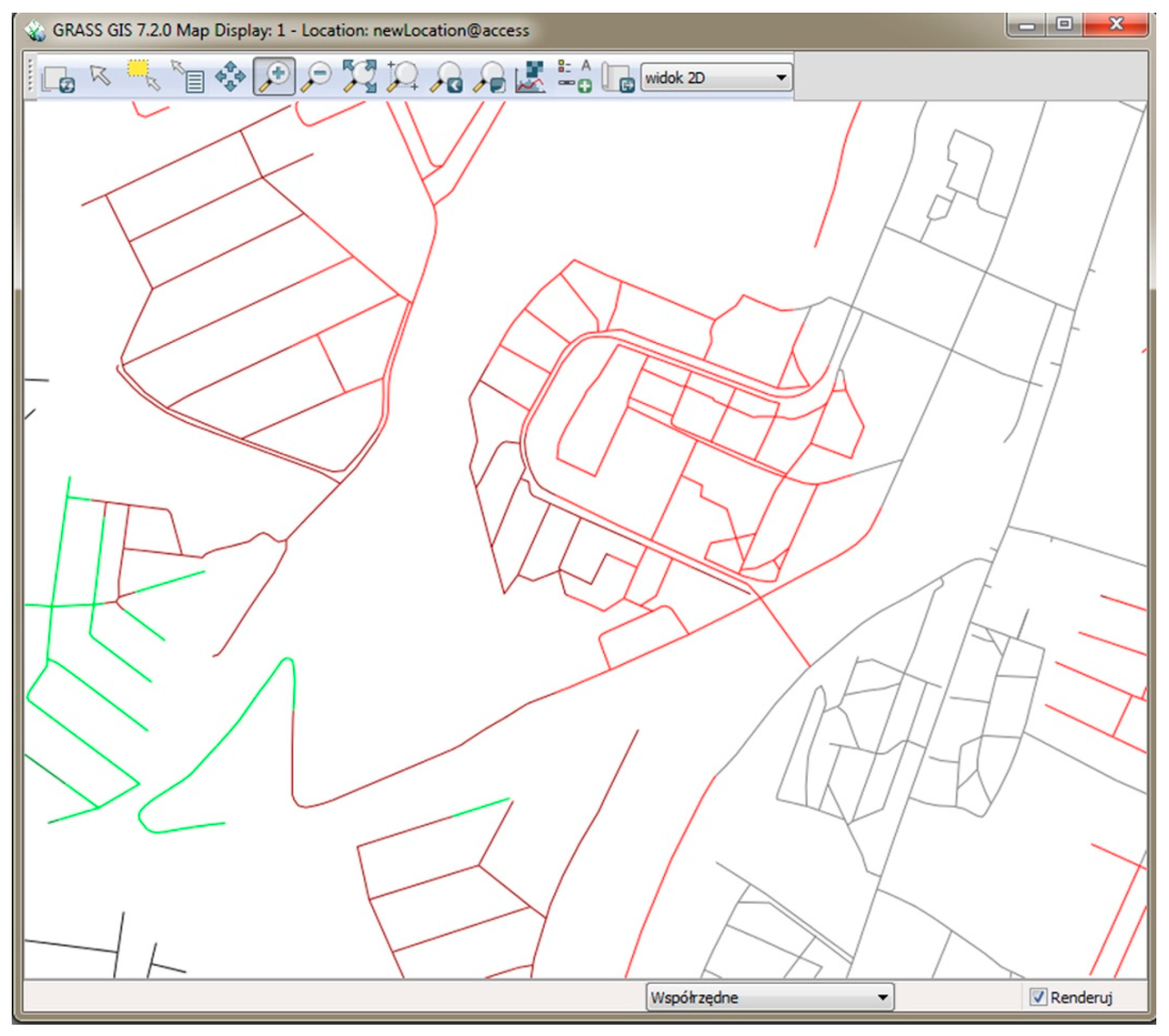
The main part of this process uses the band module to split bands of equal distances to the points (public transport stops). In our case, the distance is taken as the traveling cost and the network is divided into bands of 400-, 800-, and 1200-m width around the public transport stops. As a result, a new vector map is created with a network of lines within the distance bands; the distance within the first band is 400 m; the subsequent bands covering the distances of 400–800, 800–1200 and 1200–1600 m. This is the third step in the data preparation process; it is performed by a command line which splits a network into bands between cost isolines with an indicated distance from the center [37]. The result of this step is shown in Figure 3. Grey lines show the network within a distance of 400 m from any public transport stop; the distance between 400 and 800 m is colored red; brown and green denote distances of 800–1200 and 1200–1600 m, respectively. In the attribute table, each band is saved in a cat column with numbers 1, 2, 3, and 4 denoting the distances of 400, 800, 1200, and 1600 m, respectively. If any line remains black, that line (road or path) could not be connected with the network of lines in the line layer. The vector map thus generated is ready to be imported to QGIS software where the results of the whole process can be analyzed.
This kind of approach can be used to define areas with poor accessibility to public transport for residents of a specific street. For this purpose, a list of 10 most populous streets, supporting the highest numbers of residents with permanent addresses, was used.
3. Results
The vector layer of the network of streets and public transport stops was visualized in QGIS software. The street bands were color-coded according to their distance to the nearest public transport stop: The distance of 400 m, equivalent to a 5 min walk (highly accessible), was coded green; the distance of 800 m, equivalent to a 10 min walk (moderately accessible), was colored yellow; the distance of 1200 m, equivalent of a 20 min walk (poorly accessible) was colored orange); and the distance of 1600 m, equivalent of a 20 min walk (inaccessible) was colored red (cf. Table 2).
The resultant map of the city of Szczecin is shown on Figure 4. In this work, all the roads and pedestrian paths were taken into account. The total length of the roads and paths analyzed was 2359.2 km, of which those covering 1094.4 km (46.4%) proved highly accessible to public transport stops, while 639.8 km (27.1%) were classified as moderately accessible. Poor accessibility was shown for 306.9 km (13%) of streets and paths, and 318.2 km (13.5%) of streets and paths were classified as public-transport-inaccessible—most likely, their residents would not walk to a bus or tram stop (Table 3).
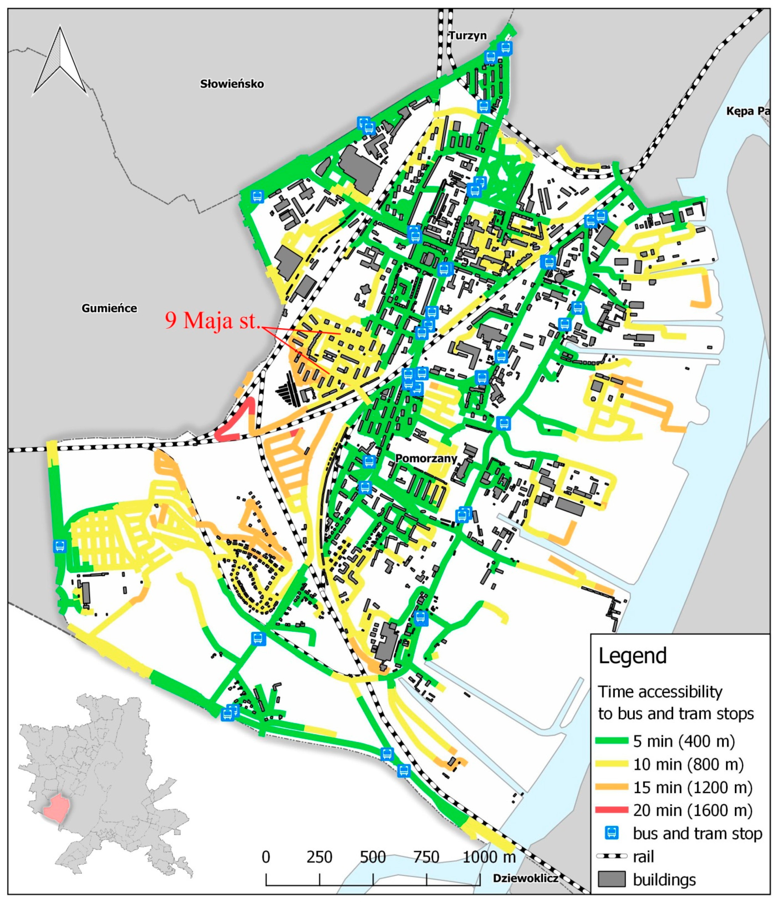
Analyses of bands with the most populous streets of the City of Szczecin showed one of those streets to be poorly connected with the public transport network. The street (9 Maja) ranks 6th among the streets with the highest number of permanently registered residents (2895) (Figure 5). The public transport accessibility for them is moderate to poor, which means they need to take up to 15 min to walk to the nearest public transport stop. For this reason, the residents may prefer to choose cars over public transport as a form of getting to their respective destinations (work, school, etc.).
Accessibility can be improved by putting a bus stop on 9 Maja Street, as shown in Figure 6. In fact, it is a circular street featuring separate blocks of flats. The number of residents living in the vicinity of that street shows that putting a bus stop there would be a reasonable move. The 2895 residents have to spend more than 10 min getting to the nearest bus or tram stop, which discourages them from using the public transport. In the City of Szczecin with its population of 403,883, there are about 220,000 automobiles, which means that the residents of 9 Maja Street could well own a total of about 1737 cars. A bus stop in the vicinity might encourage the residents to use the public transport and thus reduce the car traffic. Unfortunately, the absence of good access to the bus stop indirectly contributed to the reconstruction of the street in 2017 as demanded by the residents, whereby the car road was widened and 58 new parking spaces were put in place.
It is important to note that the band method left some yellow lines (pedestrian paths) around new bus stops, which could have resulted from a lack of connection between the road and the pedestrian path that, in reality, are connected or there is no connection at all, which forces pedestrians to walk a longer distance to get to the bus stop. In our study, the former was the case; there are plenty of pedestrian paths that are not in the database, which necessitates double checking the connections between roads and paths and filling up the lacking paths in order to get proper results. That is why this method works better in smaller areas of a city, like a neighborhood or a district.
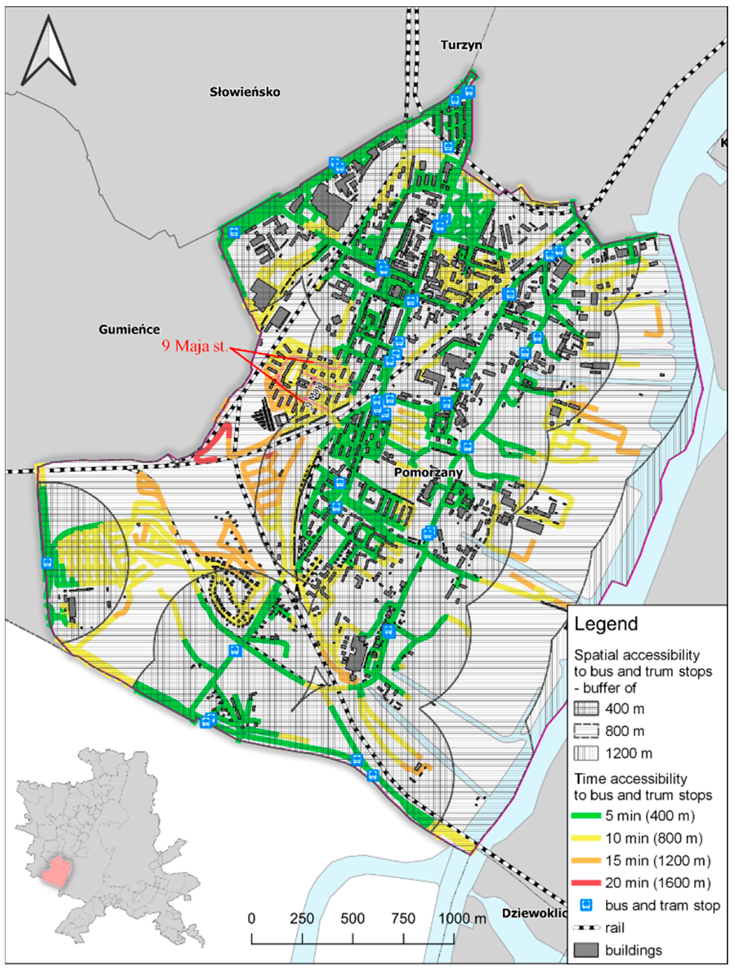
Assuming that the vector lines (roads with paths) are appropriately connected with each other and with points, the band method is more accurate than the buffers around public transport stops. As shown in Figure 7, 400-m-wide buffers around stops are wider than the high-accessibility band (400 m). The 400-m-wide buffers comprise streets classified as inaccessible by the band method (20 min walk to the nearest stop). This means that in a high-accessibility area (5 min walk, 400 m) delimited by the buffer method comprises in fact streets and paths up to 1600 m away from the public transport stop and defined as inaccessible by the band method (cf. Figure 7).
The Pomorzany neighborhood has 89.19 km of streets and pedestrian paths. Results of the band method, 47.99 km (53.8%) offer high accessibility to public transport stops, 33.8 km (37.8%) of routes provide a moderate level of accessibility, while living on 7.8% (6.95 km) and 0.5% (0.45 km) of streets and paths means poor or no accessibility, respectively, to bus or tram stops, whereby most likely the residents would not walk to bus or tram stops (Table 4). On the other hand, results of the circular buffer (400 m) approach showed 4.72 km2 out of 7.1 km2 (66.5%) of the whole Pomorzany neighborhood to be an area of high accessibility to public transport. Moderate accessibility was typical of 2.09 km2 (29.4%), whereas 0.26 km2 (3.7%) showed poor accessibility. Buffers 1200–1600 m width were located outside of the Pomorzany, which means that there were no inaccessible areas. In contrast, the band method showed 9 Maja Street to offer the residents primarily moderate and poor accessibility to public transport. The buffer method placed this street in an area of high and moderate accessibility.
4. Discussion
To reduce the number of cars in cities, it is necessary to make public transport more attractive to the residents; this can be achieved by, inter alia, improving accessibility of the public transport to residents. The comparison of the band method (v.net.iso) and the circular buffer approach, described here, shows the former to more accurately reflect the actual distance to the public transport stops, as determined by the time and distance of walking to the nearest stop. The band method could be used to facilitate finding problematic areas with poor accessibility to public transport. It measures the distance along the lines, which reflects the actual distance covered by the pedestrian. The disadvantage of this approach is that the vector line layers are incomplete. To arrive at correct results it is important that attention be paid to retaining appropriate connections between the lines of roads and pedestrian paths. Although the approach has its disadvantages, it is worthy of being applied and explored in a more advanced manner to improve its performance. This could result in a more accurate modelling of public transport accessibility to local residents. Analyses of the results obtained using the band method showed the main streets of the Pomorzany neighborhood offered residents a much higher access level to public transport than streets located away from the main routes; due to high number of residents in those streets, the accessibility of public transport there needs to be improved. Moreover, the band method is capable of indicating those areas in which access to public transport can be enhanced by, e.g., installing new tram or bus stops or by building an overpass above the rail tracks.
Author Contributions
Conceptualization, P.K.; Methodology, P.K.; Software, P.K.; Validation, P.K.; Formal Analysis, P.K.; Investigation, P.K.; Resources, P.K.; N.S.-D.; Data Curation, P.K.; Writing-Original Draft Preparation, P.K.; N.S.-D.; Writing-Review & Editing, N.S.-D.; Visualization, P.K.; Supervision, N.S.-D.
Funding
This research received no external funding.
Conflicts of Interest
The authors declare no conflicts of interest.
References
- Kittelson & Associates, Inc. Transit Capacity and Quality of Service Manual, 2nd ed.; TCRP Project 100; TRB, National Research Council: Washington, DC, USA, 2003. [Google Scholar]
- Newman, P.; Kenworthy, J. Sustainability and Cities: Overcoming Automobile Dependence; Island Press: Washington, DC, USA, 1999. [Google Scholar]
- Murray, A.T.; Davis, R.; Stimson, R.J.; Ferreira, L. Public transportation access. Transp. Res. D Transp. Environ. 1998, 3, 319–328. [Google Scholar] [CrossRef]
- Olawole, M.O. Accessibility to Lagos Bus Rapid Transit (BRT LITE) Bus Stops: An Empirical Study; CODATU XV: Addis Ababa, Ethiopia, 2012. [Google Scholar]
- Murray, A.T. Strategic analysis of public transport coverage. Socio-Econ. Plan. Sci. 2001, 35, 175–188. [Google Scholar] [CrossRef]
- Wachs, M.; Kumagai, T.G. Physical accessibility as a social indicator. Socio-Econ. Plan. Sci. 1973, 7, 437–456. [Google Scholar] [CrossRef]
- Bok, J.; Kwon, Y. Comparable Measures of Accessibility to Public Transport Using the General Transit Feed Specification. Sustainability 2016, 8, 224. [Google Scholar] [CrossRef]
- Litman, T. The Economic Value of Walkability; Victoria Transport Policy Institute: Victoria, BC, Canada, 2007. [Google Scholar]
- Gomide, A.; Leite, S.; Revelo, J. Transport and Urban Poverty: A Synthetic Index of Adequate Service; World Bank: Washington, DC, USA, 2005. [Google Scholar]
- Bhat, C.; Bricka, S.; Mondia, J.L.; Kapur, A.; Guo, J.; Sen, S. Metropolitan Area Transit Accessibility Analysis Tool; Centre for Transportation Research University of Texas: Austin, TX, USA, 2006; pp. 33–44. [Google Scholar]
- Vuchic, V.R. Transportation for Livable Cities; CUPR: New Brunswick, NB, Canada, 1999; pp. 198–201. [Google Scholar]
- Littman, T. Transit Oriented Development: Using Public Transit to Create More Accessible and Livable Neighborhoods. In TDM Encyclopedia; Victoria Transport Policy Institute: Victoria, BC, Canada, 2017. [Google Scholar]
- Sinha, K.C.; Labi, S. Transportation Decision Making; Wiley and Sons: Hoboken, NJ, USA, 2007; pp. 23–27. [Google Scholar]
- Grava, S. Urban Transportation Systems: Choices for Communities; McGraw-Hill: New York, NY, USA, 2003; pp. 1–12. [Google Scholar]
- Corazza, M.V.; Favaretto, N. A Methodology to Evaluate Accessibility to Bus Stops as a Contribution to Improve Sustainability in Urban Mobility. Sustainability 2019, 11, 803. [Google Scholar] [CrossRef] [Green Version]
- Litman, T. Evaluating Accessibility for Transport Planning Measuring People’s Ability to Reach Desired Goods and Activities; Victoria Transport Policy Institute: Victoria, BC, Canada, 2018. [Google Scholar]
- Beimborn, E.A.; Greenwald, M.J.; Jin, X. Impacts of transit accessibility and connectivity on transit choice and captivity. Transp. Res. Rec. 2003, 1835, 1–9. [Google Scholar] [CrossRef]
- Ker, I.; Ginn, S. Myths and Realities in Walkable Catchments: The case of Walking and Transit. In Proceedings of the 21st ARRB and 11th REAAA Conference 90CD-ROM), Cairns, Australia, 18–23 May 2003. [Google Scholar]
- Hine, J.; Mitchell, F. The Role of Transport in Social Exclusion in Urban Scotland; Scottish Executive, Central Research Unit: Edinburgh, UK, 2001. [Google Scholar]
- Hine, J.; Mitchell, F. Better for everyone? Travel experiences and transport exclusion. Urban Stud. 2001, 38, 319–322. [Google Scholar] [CrossRef]
- Hine, J.; Mitchell, F. Transport Disadvantage and Social Exclusion; Ashgate Publishing: Aldershot, UK, 2003. [Google Scholar]
- O’Neill, W.A.; Ramsey, R.D.; Chou, J. Analysis of transit service areas using geographic information systems. Transp. Res. Rec. 1992, 1364, 131–138. [Google Scholar]
- Groß, D.R.P.; Hamacher, H.W.; Horn, S.; Schöbel, A. Stop location design in public transportation networks: Covering and accessibility objectives. Top 2009, 17, 335. [Google Scholar]
- Hsiao, S.; Lu, J.; Sterling, J.; Weatherford, M. Use of geographic information system for analysis of transit pedestrian access. Transp. Res. Rec. 1997, 1604, 50–59. [Google Scholar] [CrossRef]
- Aultman-Hall, L.; Roorda, M.; Baetz, B.W. Using GIS for evaluation of neighborhood pedestrian accessibility. J. Urban Plan. Dev. 1997, 123, 10–17. [Google Scholar] [CrossRef]
- Phillips, C.G.; Edwards, H.R. Socioeconomic, community-based approach for developing integrated mass transit systems application to city of Baltimore, Maryland. Transp. Res. Rec. 2002, 1797, 71–79. [Google Scholar] [CrossRef]
- Foda, M.A.; Osman, A.O. Using GIS for measuring transit stop accessibility considering actual pedestrian road network. J. Public Transp. 2010, 13, 2. [Google Scholar] [CrossRef]
- Ammons, D.N. Municipal Benchmarks: Assessing Local Performance and Establishing Community Standards, 2nd ed.; Sage: Thousand Oaks, CA, USA, 2001. [Google Scholar]
- Zhao, F.; Chow, L.F.; Li, M.T.; Ubaka, I.; Gan, A. Forecasting transit walk accessibility—Regression model alternative to buffer method. Transp. Res. Rec. 2003, 1835, 34–41. [Google Scholar] [CrossRef]
- Loutzenheiser, D.R. Pedestrian access to transit: Model of walk trips and their design and urban form determinants around bar area rapid transit stations. Transp. Res. Rec. 1997, 1604, 40–49. [Google Scholar] [CrossRef]
- Ayvalik, C.K.; Khisty, C.J. Heuristic analysis of impacts of commuter rail station consolidation on pedestrian access. Transp. Res. Rec. 2002, 1793, 47–54. [Google Scholar] [CrossRef]
- Sypion-Dutkowska, N.; Leitner, M. Land Use Influencing the Spatial Distribution of Urban Crime: A Case Study of Szczecin, Poland. ISPRS Int. J. Geoinf. 2017, 6, 74. [Google Scholar] [CrossRef]
- Historia Komunikacji Miejskiej w Szczecinie. Available online: http://www.swiatowy.org/ (accessed on 14 January 2019).
- Kaszczyszyn, P. Evolution of urban structure and the influence on walkability. In Poszerzamy horyzonty, Tom IX; Bogusz, M., Wojcieszak, M., Rachwał, P., Eds.; Mateusz Weiland Network Solutions: Słupsk, Poland, 2018; pp. 136–150. [Google Scholar]
- Carr, L.J.; Dunsiger, S.I.; Marcus, B.H. Walk Score as a Global Estimate of Neighborhood Walkability. Am. J. Prev. Med. 2010, 39, 460–463. [Google Scholar] [CrossRef] [PubMed]
- 10 Techniques for Making Cities More Walkable. Available online: https://www.citylab.com/solutions/2012/12/10-techniques-making-cities-more-walkable/4047/ (accessed on 14 January 2019).
- Grass Tutorial. Synopsis 1. Available online: https://grass.osgeo.org/grass74/manuals/v.net.iso.html (accessed on 14 January 2019).
- Grass Tutorial. Synopsis 2. Available online: https://grass.osgeo.org/grass77/manuals/v.net.html (accessed on 14 January 2019).
Figure 1.
Step 1—importing vector layers to GRASS plug-in.
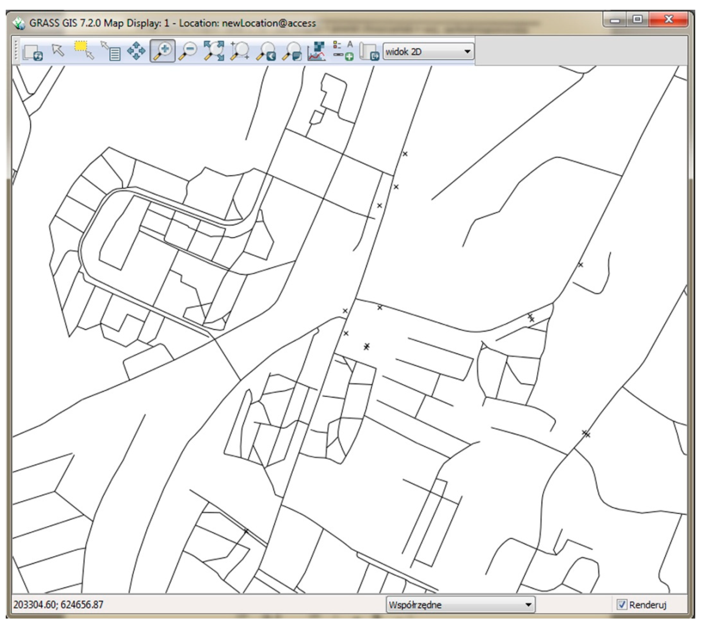
Figure 2.
Step 2—connecting points to lines

Figure 3.
Step 3—dividing network to bands of equal distances.

Figure 4.
Current public transport accessibility for the City of Szczecin residents. * The “inaccessible” category comprises also roads and paths located at a longer distance.
Figure 4.
Current public transport accessibility for the City of Szczecin residents. * The “inaccessible” category comprises also roads and paths located at a longer distance.
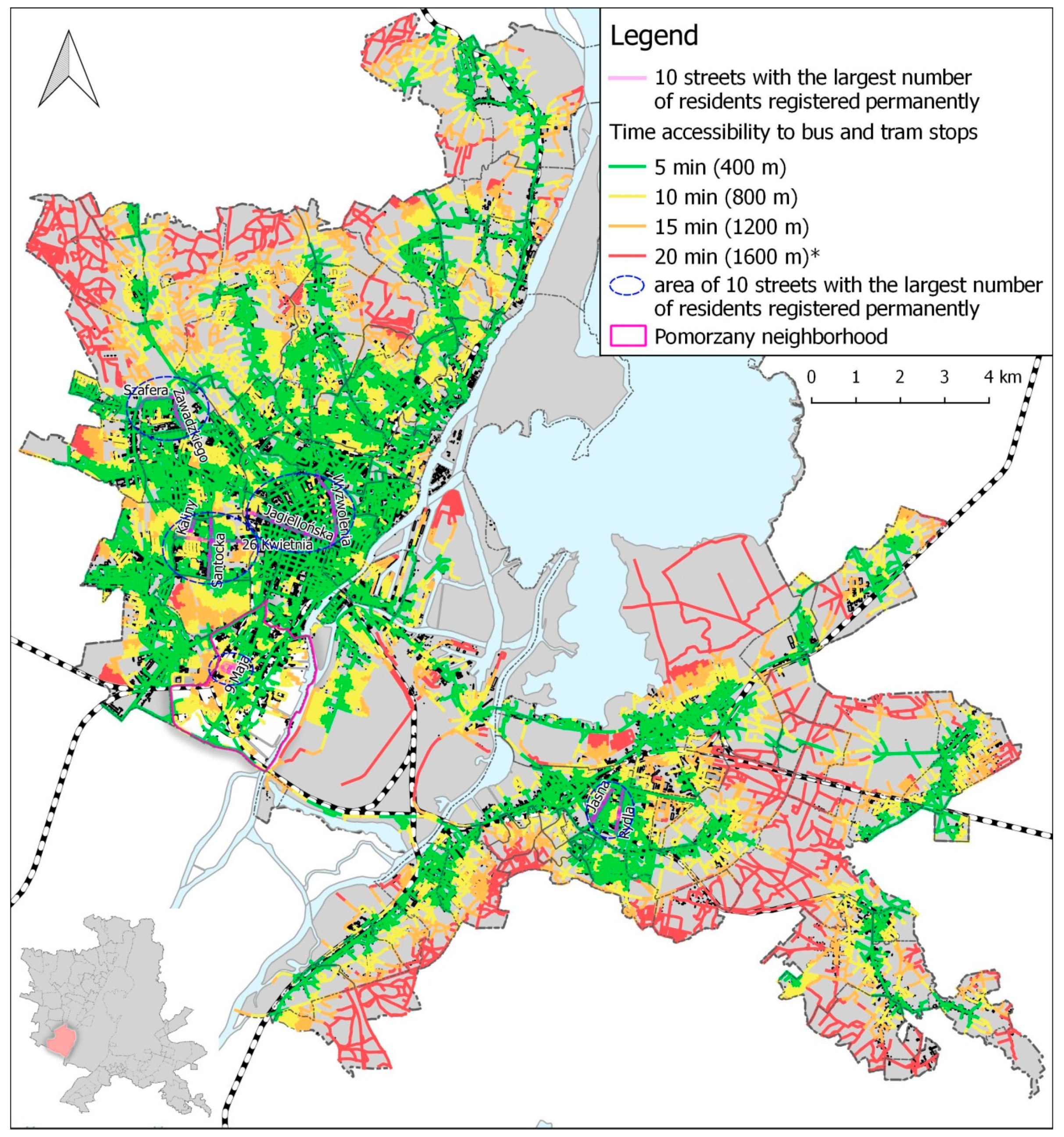
Figure 5.
Current public transport accessibility for the Pomorzany neighborhood residents. * 9 Maja Street is the 6th most populous street in Szczecin.
Figure 5.
Current public transport accessibility for the Pomorzany neighborhood residents. * 9 Maja Street is the 6th most populous street in Szczecin.

Figure 6.
Public transport accessibility for the Pomorzany neighborhood residents following installation of a new bus stop.
Figure 6.
Public transport accessibility for the Pomorzany neighborhood residents following installation of a new bus stop.
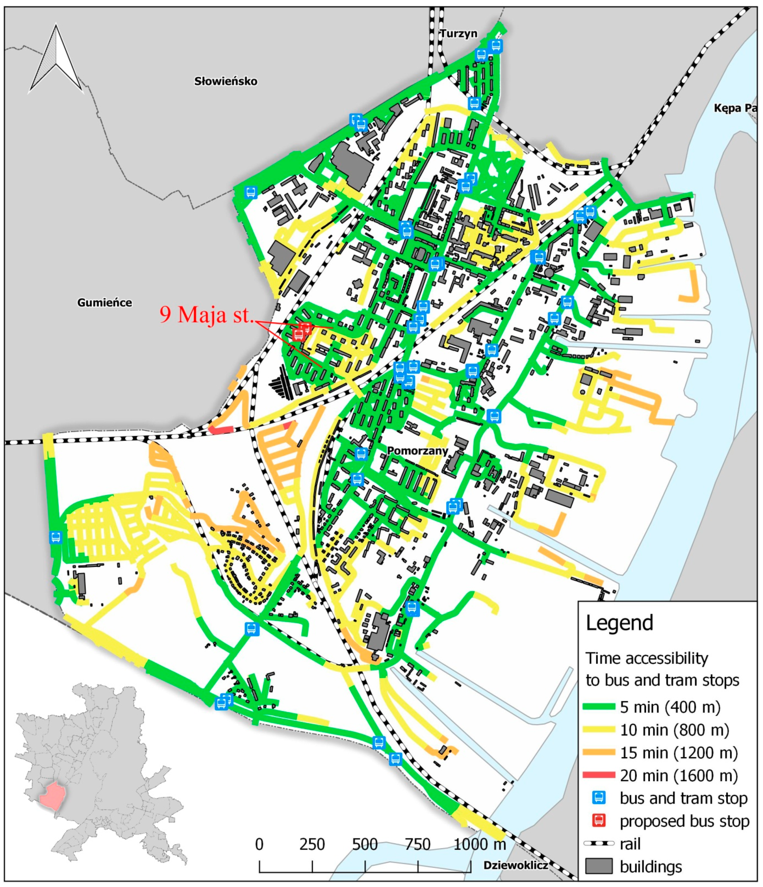
Figure 7.
Results of band method (GRASS plug-in) vs results of the circular buffer method.


Table 1.
Top 10 most populous streets in the city of Szczecin (the highest numbers of residents with permanent addresses) in 2017.
Table 1.
Top 10 most populous streets in the city of Szczecin (the highest numbers of residents with permanent addresses) in 2017.
| No. | Street | Population |
|---|---|---|
| 1 | Zawadzkiego | 4181 |
| 2 | Szafera | 3917 |
| 3 | Wyzwolenia | 3620 |
| 4 | Jasna | 3480 |
| 5 | Santocka | 3271 |
| 6 | 9 Maja * | 2895 |
| 7 | Rydla | 2875 |
| 8 | Jagiellońska | 2835 |
| 9 | 26 Kwietnia | 2758 |
| 10 | Kaliny | 2696 |
Source: https://wszczecinie.pl/aktualnosci,zgadnijcie. * Streets located in the case study area.
Table 2.
Public transport spot accessibility classification.
| Distance to Public Transport Stop [m] | Time [min] | Color Code | Accessibility Level |
|---|---|---|---|
| 0–400 | 0–5 | High | |
| 400–800 | 5–10 | Moderate | |
| 800–1200 | 10–15 | Poor | |
| 1200–1600 | 15–20 | Inaccessible |
Table 3.
City of Szczecin streets and accessibility of public transport for their residents.
| Distance to Public Transport Stop (m) | Time (min) | Color Code | Accessibility Level | Length (km) | Percentage (%) |
|---|---|---|---|---|---|
| 0–400 | 0–5 | High | 1094.4 | 46.4 | |
| 400–800 | 5–10 | Moderate | 639.8 | 27.1 | |
| 800–1200 | 10–15 | Poor | 306.9 | 13 | |
| 1200–1600* | 15–20 * | Inaccessible | 318.2 | 13.5 |
* the “inaccessible” category comprises also roads and paths located at a longer distance.
Table 4.
Length of bounds for set up divisions of specific accessibility levels in Pomorzany neighborhood compared to buffer method.
Table 4.
Length of bounds for set up divisions of specific accessibility levels in Pomorzany neighborhood compared to buffer method.
| Method | Distance to Public Transport Stop (m) | Time (min) | Color/Pattern Code | Accessibility Level | Length (km)/Area (km2) | Percentage (%) |
|---|---|---|---|---|---|---|
| Band (length) | 0–400 | 0–5 | High | 47.99 | 53.8 | |
| 400–800 | 5–10 | Moderate | 33.8 | 37.9 | ||
| 800–1200 | 10–15 | Poor | 6.95 | 7.8 | ||
| 1200–1600 | 15–20 | Inaccessible | 0.45 | 0.5 | ||
| Buffer (area) | 0–400 | 0–5 |  | High | 4.72 | 66.5 |
| 400–800 | 5–10 |  | Moderate | 2.09 | 29.4 | |
| 800–1200 | 10–15 |  | Poor | 0.26 | 3.7 | |
| 1200–1600 | 15–20 | none | Inaccessible | 0 | 0 |
© 2019 by the authors. Licensee MDPI, Basel, Switzerland. This article is an open access article distributed under the terms and conditions of the Creative Commons Attribution (CC BY) license (http://creativecommons.org/licenses/by/4.0/).
Share and Cite
MDPI and ACS Style
Kaszczyszyn, P.; Sypion-Dutkowska, N. Walking Access to Public Transportation Stops for City Residents. A Comparison of Methods. Sustainability 2019, 11, 3758. https://doi.org/10.3390/su11143758
AMA Style
Kaszczyszyn P, Sypion-Dutkowska N. Walking Access to Public Transportation Stops for City Residents. A Comparison of Methods. Sustainability. 2019; 11(14):3758. https://doi.org/10.3390/su11143758
Chicago/Turabian StyleKaszczyszyn, Piotr, and Natalia Sypion-Dutkowska. 2019. "Walking Access to Public Transportation Stops for City Residents. A Comparison of Methods" Sustainability 11, no. 14: 3758. https://doi.org/10.3390/su11143758
Note that from the first issue of 2016, this journal uses article numbers instead of page numbers. See further details here.