Article

An Analysis of Environment Behavior Relationships towards the Design of a Local Mixed-used Street: Based on Behavior Settings of Belgium Street in Cebu City, Philippines

1
Graduate School of Engineering, Hokkaido University, Sapporo 060-8628, Japan
2
Faculty of Engineering, Hokkaido University, Sapporo 060-8628, Japan
*
Author to whom correspondence should be addressed.
Sustainability 2018, 10(9), 3230; https://doi.org/10.3390/su10093230
Submission received: 16 August 2018 / Revised: 2 September 2018 / Accepted: 5 September 2018 / Published: 10 September 2018

Abstract

:
Streets function as public spaces that improve the aspects of social sustainability by accommodating the daily activities of people, further contributing to the strengthening of relationships in society and the expansion of people’s social networks. This research focuses on studying the relationship of human behavior and the street environment in Cebu, Philippines, which can help to contribute to a better approach towards street improvements. Filipino behavior settings were identified and classified based upon people’s activities on the street that were gathered using the Behavior Mapping Method. From the analysis of behavior settings on the behavior maps, the current use of the street has been classified into zones, and has shown potential for street sharing by being flexible enough to accommodate both behavior settings and vehicular traffic at different times. Based on the findings of the analysis, design proposals were created as an interview tool to extract information from respondents on the street. From the results of the interviews, considerations such as the importance of preserving the existing behavior settings, promoting safety, and preventing conflicts on the street can be used to develop an improved street design.

1. Introduction

1.1. Background

In developed urban environments such as cities, public spaces are recognized as elements that contribute towards sustainable development [1,2]. Streets are public spaces that function as the city’s vital organs [3] that act as paths which improve the connectivity of the city with other environmental elements [4]. They promote social sustainability by improving community engagement [5], and giving people opportunities to interact with one another, play, and relax [6,7,8]. In addition, streets function as centers that promote commercial activity [9] and provide a means of active travel for health and well-being [10]. Culturally, streets in Southeast Asia mentioned by Oranratmanee and Sachakul (2014, p. 213) were described by scholars as “lively” compared to those of western streets [11]. In the past, first world countries have used streets for the main purpose of vehicular traffic, while third world countries have already used streets as public spaces that served areas with dense populations, and were used to make up for the lack of open spaces [12]. Streets in the Philippines share some similarities with those of other Southeast Asian countries in terms of appearance and how they are used as public spaces; some minor streets in the Philippines were described by Dela Paz (2009, p.97) as having a “tightness of the right-of-way” emphasized by their lack of sidewalks and residences with no setbacks while accommodating two lanes for vehicular circulation, but are still utilized by people for their activities [13]. This utilization of street space can be explained by how Filipinos perceive their use of public space. Filipinos use public spaces in such a way that they become the user’s private property at the time of their use [14]. This is further explained by Mojares (1999, p. 124) in the description of the Filipino’s concept of space as “malleable, negotiable and loosely bounded”, which is caused by the lack of usage of physical boundaries around houses such as fences and occupation of sidewalks for squatting and vending [15]. In addition, negotiable behavior regarding vehicular traffic can be seen on these streets, as drivers of Jeepneys (a means of public transportation in the Philippines) try to negotiate with each other for space [15]. Despite how Filipinos use streets, their development in the Philippines has begun to evolve with the design of streets in developed countries. After the Second World War, the development of suburbs caused streets to become more private and controlled [16]. In addition, the establishment of commercial malls began to depersonalize streets as public spaces. These commercial malls acted as exclusive public spaces for those who can spend money on their facilities, thereby displacing vendors and those without money out onto streets, which has changed the perception of streets in the Philippines as chaotic places filled with crime [16].

1.2. Research Status

There have been growing concerns regarding the development of cities around the world. Recent research has focused on city improvement through participatory studies between the relationship of users and urban park benefits [17], and through understanding the pathologic growth of cities [18]. In the Philippines, similar discussions for the need of more green spaces have advocated the many benefits that they can provide to growing cities [19,20,21,22,23]. In response to the needs of these developing cities which aim to promote both sustainability and livability, architectural and planning solutions for the increasing need of public spaces have been proposed and implemented throughout Philippine cities. Such examples can be seen in Iloilo City, in which a river esplanade was opened in 2012 that transformed a neglected riverside of the city into an award-winning, successful outdoor space to improve the living environment and accommodate people’s activities [24]. In Metro Cebu, a Green Loop was proposed to improve the increasing transportation problems within cities, while aiming to provide “comfortable road spaces for all users” [25]. Road sharing experiments were also conducted along the streets of Cebu City for the purpose of advocating the need to prioritize pedestrians and cyclists [26]. On the other hand, there was no approach that focused on making improvements based on understanding how people use of street for their personal activities (Figure 1). In addition, the government has begun to see people’s behavior on streets in terms of its negative effects, such as being related with crime. Recently, the government focused on removing activities from the streets by establishing rules regarding the prohibition of loiterers, and conducting patrols to catch violators in order to promote the welfare and safety of the citizens [27,28]. These measures, however, have received mixed reactions, and were criticized as being anti-poor [29].

1.3. Purpose and Significance of Research

The approaches in the development and management of streets as mentioned above will have unknown effects on the daily lives of the people, especially the poor. Emphasis has been placed upon the importance of understanding the daily lives of the inhabitants on streets as important considerations in the design process [30]. Recently, countries have begun to correct their design of streets by prioritizing pedestrians over vehicles, to make streets more accessible for people, thereby making communities and cities more sustainable. Solutions such as pedestrian streets that are permanently closed to vehicular traffic, or those having a time schedule for vehicular traffic, have been implemented to promote accessibility for pedestrians. In addition, methods such as mental and participatory mapping have been used to gather information from people based on their personal experiences [31], while the use of geo referenced mapping and standards such as TOD have been used to further analyze the urban environment [32]. However, in the situation of the Philippines, a lack of priority for pedestrians, the presence of social inequalities, and the lack of participation and exchange of ideas between government, professionals, and users have mostly led to underutilization, and poor design of streets. Therefore, this research tries to address this gap in the Philippines by understanding the current conditions of environment behavior relationships on streets. Studying the relationship between the behaviors of people and street spaces by recording their activities on the streets through the use of the behavior mapping method can provide further understanding as to how Filipino people use streets in the Philippines. Considering the integration of these environment behavior relationships in the design of streets can further develop affected areas into sustainable communities by preserving their way of life and existing street culture, and can strengthen the relationships in their society and expand their social networks. In addition, this research can lead to proper recommendations for street improvement in terms of planning, design, and street management, which could be an original contribution towards the development of public spaces in the Philippines and elsewhere.

2. Materials and Methods
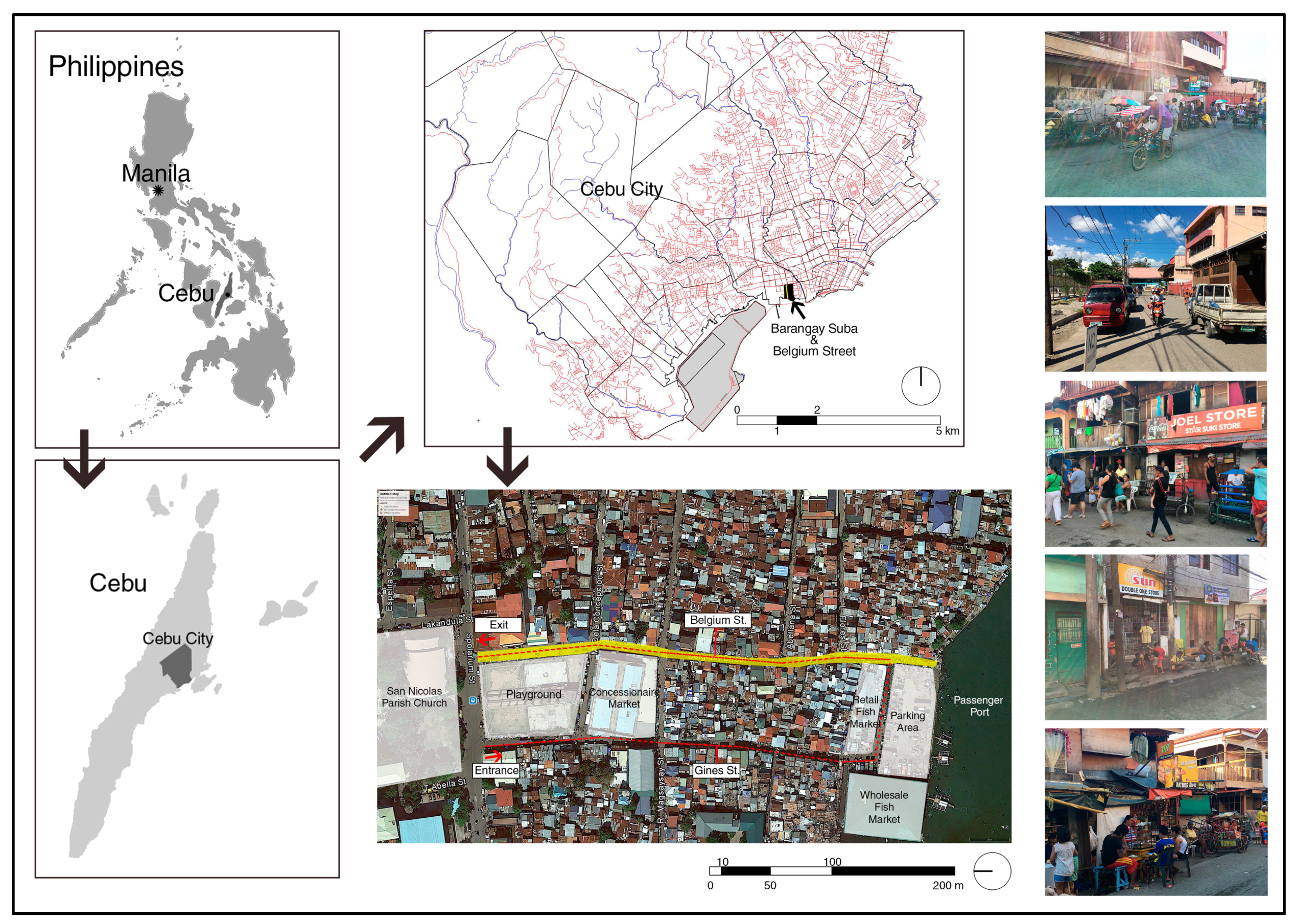
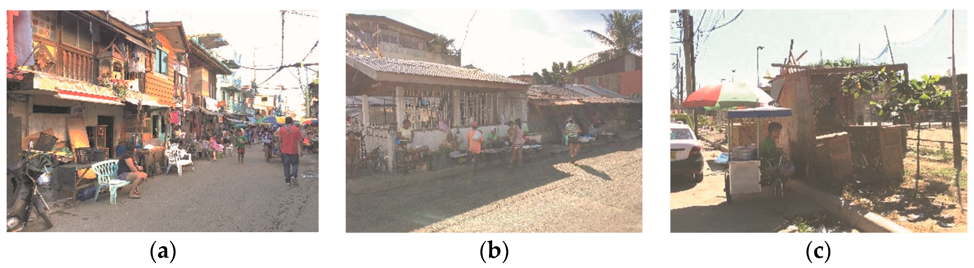
2.1. Research Area

The chosen research area is Belgium Street, located in Cebu City, Philippines (Figure 2). It is located in a Barangay (smallest administrative unit in the Philippines) called Suba, a part of a former Slum Improvement Resettlement area established during the 1970s. The resettlement area was re-blocked, titled, and given to the beneficiaries who once squatted in these areas. The land areas of houses are minimal, which causes owners to build higher while attaching their houses to one another to get more living space. However, because some of these houses are not well constructed and are made of light building materials, they are susceptible to fires. In this area, the only open space they have along this street is a playground that only accommodates sports such as basketball and volleyball. Belgium Street contains the largest fish markets in the city along its stretch, and supports a variety of activities such as vending, and outside socializing. These activities are scattered all around the street, occupying sidewalks and part of the carriageway, thereby making it difficult for pedestrians, cars, delivery trucks, and fire engines that need to pass in case of emergency. With regards to circulation, Belgium Street functions as a one-way street, and is the exit for delivery trucks who come from delivering fish to the markets. However, this is not well-implemented, as drivers still move in counter flow to access the market and the small streets connected to it. The street appears to look disorganized because of the presence of markets and activities that continue to occur together throughout the day, from early in the morning until late in the evening. Plans to improve the current situation of Belgium Street have considered widening the street, providing plant strips, and making new buildings provide arcades along its stretch based on the city’s zoning ordinance for future development (Table 1). In addition, Barangay Suba conducts clearing activities by removing stalls and parked vehicles from the sidewalks and carriageway, in order to keep Belgium Street organized and safe for people. Despite this, people return to their places after clearing activities have ended. These activities along Belgium Street are perceived to cause negative effects, as they present dangers to pedestrians and drivers; however, the method used for improving the current situation has been ineffective. The street shows the potential to accommodate mixed-use functions, such as people’s activities together with vehicular traffic, which make it a good research area for the study.

2.2. Data Collection

An investigation was conducted from 5–17 December 2017, over two weekdays and two weekends, to ensure consistency and to observe the stationary daily activities that occurred in the street. First, a base map was constructed which included the existing structures and the kinds of occupational use that the structures accommodated. Second, activities on the street were recorded on the base map using the method of Behavior Mapping [33]. Behavior mapping is a method wherein activities are recorded on a map to understand people’s behaviors through activities in relation to the existing buildings and spaces on a street. To get more information on these behaviors, activities were recorded at different times of the day, and used with other collected behavior maps by layering them one on top of the other to discover certain patterns, such as the location of different types of activities on the map, movement of activities at different times, and changes of activities throughout the day. In addition, this method required the author to stay in the area during data collection, wherein he was able to observe the current situation of the street. This gave the author the opportunity to understand people’s behaviors at a personal level and gather information that cannot be collected by the behavior mapping method alone, such as sounds, smells, and movement of vehicular traffic, making it an ideal method for studying behavior on the street. For this research, activities were recorded at 5 different time frames for both weekdays and weekends. Data collection occurred on the dates of 12th December (Friday) and 9th December (Saturday) in the hours from 4:00–5:00 and 20:00–21:00, and on the dates of 7th December (Thursday) and 17th December (Sunday) in the hours of 8:00–9:00, 13:00–14:00 and 16:00–17:00. The route for data collection passed through Belgium Street (Figure 3). The author began from Spolarium Street and walked towards the port area while recording all activities on one side. After reaching the port area, the author turned to walk back towards Spolarium Street along the opposite side of the street while recording the rest of the activities on the behavior maps (Figure 3).

2.3. Classification of Behavior Settings

Recorded activities were classified into Behavior Settings [34,35] by grouping similar activities and their location on the street, which can be seen on the behavior maps (Figure 4). However, classifying behavior settings cannot be limited to a two dimensional format because of the lack of three dimensional information, which is why captured photos were used to further explain the relationship of the activities, and how they use the built environment of the street. The idea of classifying activities into behavior settings was used to create a template of behaviors that commonly occur on the street, and which could also be used for common behavior settings that occur in other streets. In addition, the classification will further aid analysis by reducing the number of activities that need to be analyzed on the street. The nomenclature of the classifications of behavior settings and their types were named to describe the purpose of the activity in relation to its environment. The major classifications were specifically named using the Visayan language of the Philippines to properly distinguish them as Filipino behaviors that came from Cebu, Philippines.

2.4. Spatial and Time Analyses

After the classification, further analysis was conducted with the behavior settings on the behavior maps together with photographs, in order to understand the relationship of behavior settings in space and time. First, a spatial analysis was conducted to locate spaces occupied by behavior settings on the street to determine why these settings occur on Belgium Street. The analysis was conducted by overlaying the different recorded behavior maps together to determine the specific location of behavior settings on the street. Second, a time analysis was conducted to understand the change and movement of behavior settings at different days and times by also using the overlaid behavior maps, similar to the Spatial Analysis.

2.5. Interview Analysis

In order to grasp the users’ ideas and comments for the future improvements of Belgium Street, interviews with twenty-two respondents were conducted by using two sets of design proposals as interview tools. These designs were created to help respondents visualize improvements based on the findings of the spatial and time analyses, and to extract their comments and ideas regarding the proposed improvements. After the presentation of the design proposals, discussions with respondents were held, with questions regarding their scheme preference, comments on each scheme, and the significance of the street to their daily lives.

3. Results

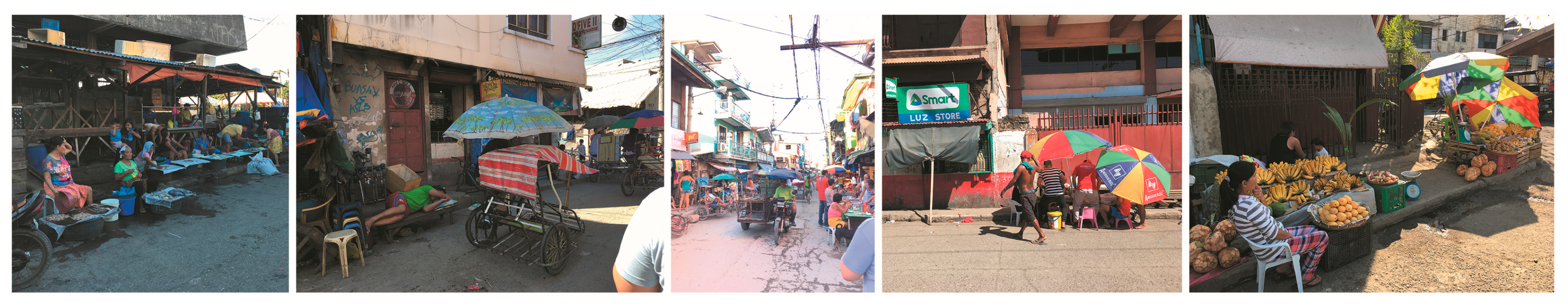
3.1. Behavior Settings

Four major classifications of behavior settings and their types have been identified on Belgium Street (Table 2). The first classification is called “Istambay sa Gawas” (shortened to IG), which means “to stand by outside” in the Visayan language. Istambay is described in the Philippines as an activity done by the unemployed, wherein they would sit outside and do nothing. For this research, it was defined to provide a setting wherein people stay outside in order to gather and socialize with others. The first type of IG is called “In a Private Meeting” (IG-1), in which the type forms a setting wherein users use spaces such as niches and enclosures provided by stores and makeshift shelters to gather and socialize with others. The second type is called “Around the Family Circle” (IG-2). This type occurs when residents occupy the street for activities such as entertaining guests, family bonding, and other household activities, creating a semi-private space on the street.
The second classification of behavior setting is called “Pahangin sa Dalan” (shortened to PSD) which means “to feel the breeze along the street” in Visayan. PSD provides a setting wherein people go outside not to just feel the breeze, but also to relax, attain a peace of mind, and pass the time by watching activities along the street. The first type of PSD is called “Alfresco Dining” (PSD-1). This type occurs when users are having a meal or drink while facing the street. Aside from the purpose of eating or having a drink, they are actually there to relax by watching activities along the street at the same time. The second type is called “Idling Around” (PSD-2), which occurs when users stay and face the street to watch activities. By watching activities, users are able to relax and entertain themselves while they are on a break. The third type is called “Blending with the Streetscape” (PD-3) which occurs when users stay on the street to sleep, an activity usually done in the house rather than on the street.
The third classification of behavior settings is called “Patagad” (PD) which means “to seek attention” in Visayan. PD provides a setting wherein some people such as vendors and tricycle drivers position themselves along the street to get attention from potential customers and make a profit.
The last classification of behavior settings is called “Pagtapok” (PT) which means “to form a crowd or group” in Visayan. PT provides a setting wherein different people, whether they know each other or not, crowd around a particular activity of interest along the street. The first type is called “Little Adventures” (PT-1) that occurs when children gather together. Children gather together in order to have fun and to socialize with each other. The second type is called “Being one with the Crowd” (PT-2), that occurs when a particular event happens. The event attracts people who are not acquainted with each other to crowd around and witness the event.

3.2. Spatial Analysis

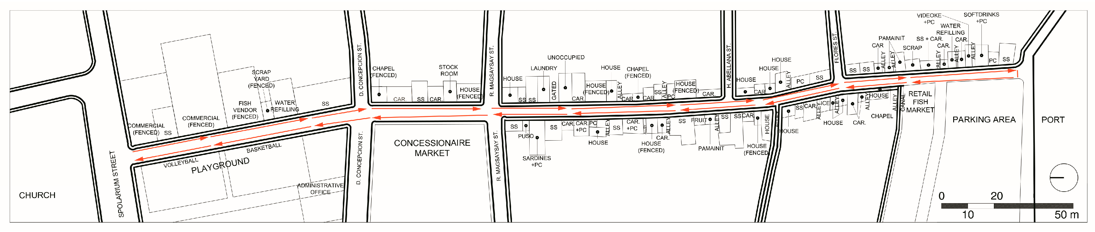
3.2.1. Location of Behavior Settings along Belgium Street

The locations of behavior settings were plotted on the behavior map which was divided into three segments for the analysis based on the different amenities. Segment 1 is bounded by the Spolarium and D. Concepcion streets which contains the playground and commercial buildings. Segment 2 is bounded by D. Concepcion and R. Magsaysay streets, containing the concessionaire market, while segment 3 is bounded by R. Magsaysay Street and the port area, containing the retail market (Figure 5).
PSD and IG behavior settings were mostly located along segments 2 and 3, which contain the fish markets and residences with shops. For the PSD behavior setting types, PSD-1 types were located in front of shops that sell food and drinks. Customers of shops would dine on seating areas that occupy sidewalks and part of the carriageway while facing the street to relax by looking at street activity. PSD-2 types were located along the sidewalks, in front of residences, and on part of the carriageways, by both residents and non-residents. People occupied the street by just standing or sitting on the sidewalk or on furniture placed along the street. PDS-3 types were also located along the sides of the street, wherein people slept on furniture.
For IG behavior setting types, IG-1 types were located along stores with setbacks and with makeshift canopies that formed spaces for people to gather themselves in. On the other hand, IG-2 types were located in front of residences and alleys which were used as a house extension that resembles a living area for families to gather around or entertain guests.
The PD behavior setting was mostly located near areas such as markets and playgrounds where potential customers would pass through or congregate. Tricycle drivers and vendors would also locate themselves in spaces such as street corners, intersections, and sidewalks, in order to make themselves visible to customers in order to sell their products and services.
For PT behavior settings, the PT-1 type occurred along intersections, street corners, and along segment 3, flat and open spaces where children could play. The PT-2 type occurred along segment 1, which contained the playground that attracted people to gather around and witness the games being played.

3.2.2. Causes of the Occurrence of Behavior Settings along Belgium Street based on Street Use

Based on the location of the behavior settings, the observation and analysis of the relationship between the behavior settings and their physical environment on the behavior maps have led to the discovery of the causes of the occurrence of behaviors settings on the street (Figure 6). First, the need to appropriate the street caused by the lack of space in houses was the reason for both PSD and IG behavior settings to occur on Belgium Street. In order to cope with the difficulties of their living spaces, residents appropriated parts of the street by using furniture, make-shift canopies, and sometimes themselves, which functioned as boundaries along parts of sidewalks and carriageway, in order to gain more space for their personal activities. It has been observed that the appropriated spaces served the purpose of accommodating residents’ less private activities, such as socializing with others, relaxing outside, and also for business opportunities wherein they expanded the seating area on the street for customers to use. Some of the appropriations occupied the sidewalks, forcing pedestrians to share the carriageway with vehicles. On the other hand, it has also been observed that residents only appropriated up to a certain portion of the carriageway, as they were aware that trucks, tricycles, and other vehicles still passed through the street.
Second, appropriated spaces on the street have caused discontinuity on the use of sidewalks, which have created small areas of unused spaces along the street. The creations of such spaces in addition to street corners and intersections have become places for opportunities causing PD behavior settings to occur. Vendors and tricycle drivers noticed these pockets of unused spaces and occupied them to earn a living. The PSD-2 type also occurred when people used the spaces to relax, or to be entertained by the activity on the street. Behavior settings also occurred on the carriageways such as PT-1 types. The flat areas and intersections of the street were occupied by children to play games, because of the lack of open spaces in the area.
Third, the playground along segment 1 accommodates sports played by people on their free time. These sports become street events which caused the PT-2 behavior setting type to occur. People anonymously gathered around along the sidewalks in front of the playground to watch games during their free time. In addition, PT-2 also attracted PD behavior settings.

3.3. Time Analysis

3.3.1. Weekday and Weekend Comparison

A comparison between weekdays and weekends was performed to confirm changes in Behavior settings. A table presenting the quantities of behavior settings and time frames reveals that PSD behavior settings mostly occurred on the street, while PT behavior settings occurred the least (Table 3). Among the behavior setting types, PSD-2 mostly occurred on the street, while PSD-3 occurred the least. Despite relaxation being most favored, behaviors involving sleep rarely occurred. When comparing weekdays and weekends in terms of quantity, there was only a slight increase in quantity during weekends. This slight increase indicates that these behavior settings occur every day, and are a routine in people’s daily lives on the street. When comparing the different time frames, 4:00–5:00 and 20:00–21:00 have the least quantity of behavior settings, as this time frame occurs early in the morning and late in the evening, while most behavior settings happened during 16:00–17:00 for both weekdays and weekends.

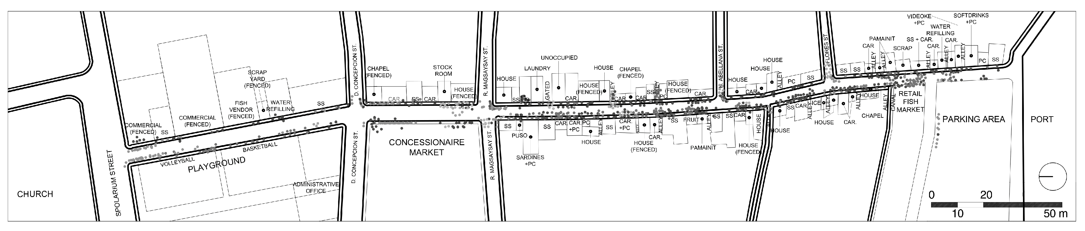
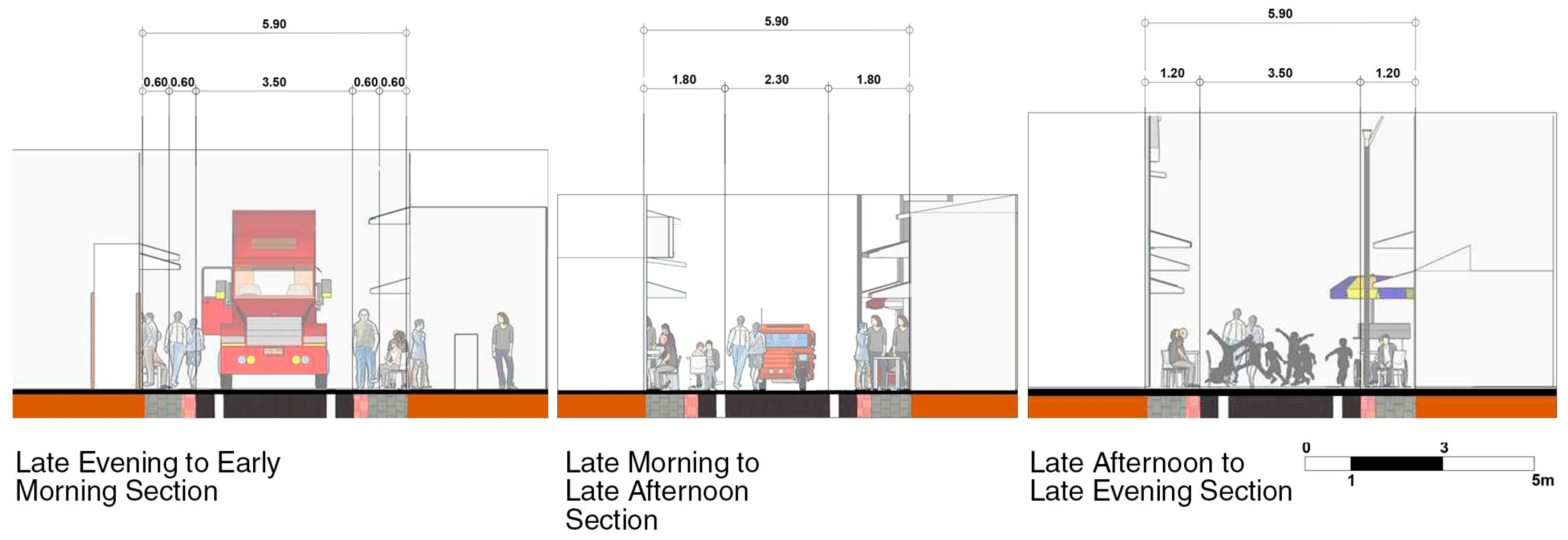
3.3.2. Movement of Behavior Settings along Belgium Street

Based on the analysis of the location of behavior settings at different time frames, a pattern of change and movement of behavior settings in five time frames along Belgium Street was discovered (Figure 7). The first pattern of movement occurred from 4:00–5:00 as trucks delivering fish caused commercial activities to intensify along the retail market at segment 3 and the concessionaire market at segment 2. At this time, the street was mostly used by fish market workers and customers, while most residents who lived along segment 3 were asleep. However, residents who lived near the markets operated their shops on the same time schedule, which caused PSD and PD behavior settings to occur. Some of these workers are contractual and would gather in these shops to relax during their break, while seeking for other job opportunities in market. Vendors and tricycle drivers take advantage of the opportunity by trying to sell their products and services to customers from the market.
The next movement occurred at 8:00–9:00, when less fish deliveries caused the intensity of fish market activities decline, changing the focus of activities towards the residences in segment 3. At this time, these residents open their shops, taking over the use of the street from the workers. These activities further influence behavior settings, causing behaviors such as PSD, IG and PD to occur. It has been observed that most people occupied the eastern side of the street.
During 13:00–14:00, while there was a second delivery of fish, the quantity of behaviors began to decline while users shifted towards the western side of the street because of the heat. It has been observed that during the day, there was a relationship between vehicles and people regarding the use of the street. When there were no vehicles, people occupied more space on the carriageway, but still provided space for people to walk and for smaller vehicles such as tricycles to pass through. When vehicles had to pass through, people would move out of their way to adjust for the vehicle, and would resume their use of the street after the vehicle was able to pass through.
The next movement occurred at 16:00–17:00 when the markets were closed. At this time, people came home from work and school to take time to rest on the street. In addition, people during their free time would play sports on the playground along segment 1, which influenced behavior settings such as PD and PT-2. The people’s free time on the street influenced behavior settings such as PSD, IG, and PT-1 behavior settings along segment 3.
Lastly at 20:00–21:00, behavior settings diminished as residents closed their shops and returned to their homes to get ready to sleep. The movement pattern would begin again at around midnight, as workers would begin to prepare for the next delivery of fish and commercial activities would begin to shift back towards the markets.

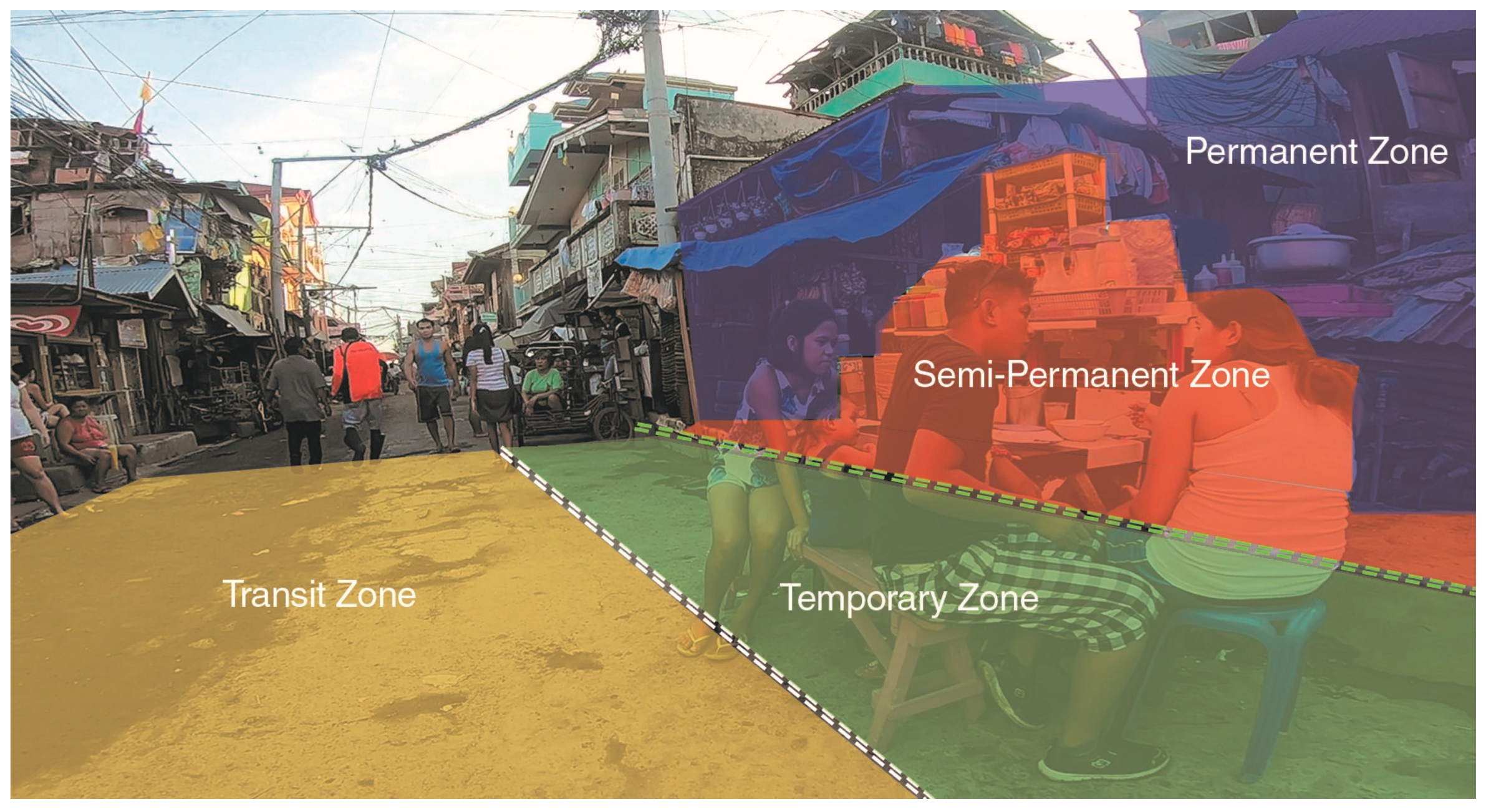
3.4. Summary of Results from the Spatial and Time Analyses

From the spatial analysis, PSD and IG behavior settings occupy areas along sidewalks and in front of residents and shops. PD behavior settings occupy intersections, street corners and areas near potential customers, such as markets, while PT behavior settings are located in front of the playground and along the areas of street where children have space to play. In addition, the appropriation of street space, use of unused spaces from discontinued sidewalks, and gathering around events caused by the playground, show that residents and other users maximize the use of street for the purpose of not only circulation, but also for fulfilling their needs such, as for profit making, extension of their living space, socialization, recreation, and relaxation. All these behavior settings occur together on the street, signifying the importance of Belgium Street as a public space that accommodates the activities needed by people in their daily lives.
From the time analysis, the behavior settings were discovered to be daily occurrences caused by the consistency of the location of behavior settings on the street at different times. The street has also shown signs of flexibility, as it can accommodate a change of users and their activities at different times, such as the workers occupying the street at night, with the residents occupying it during the day. In addition, people who appropriated parts of the street were able to adjust with the vehicular traffic. Despite occupying the street, they were able to give way to vehicles in order to keep themselves safe, and then reclaim back the space when there were no more vehicles.
From both analyses, it has been discovered that the use of Belgium Street based on the study of behavior settings can be divided into zones that explains the current use of the street (Figure 8):
  • Permanent Zone—This zone consists of permanent structures such as the built residents that are bounded by their property lines.
  • Semi-Permanent Zone—This zone consists of the sidewalks which accommodate activities and elements such as vending stalls, furniture and retractable canopies bounded by the edge of the curb.
  • Temporary Zone—This zone occupies part of the carriageway, and is flexible in nature, as it can accommodate activities and elements such as the lightweight furniture and parked vehicles that are easy to move away from vehicular traffic or during demolitions by the government. In addition, it substitutes as sidewalks for pedestrians to walk on at different times.
  • Transit Zone—This zone consists of the circulation area mainly for pedestrian and vehicular traffic.
The findings of the analyses reveal that the street’s flexibility can accommodate multiple activities in different places and times. Users being able to adjust with one another in certain situations implies that the street has the potential to be improved by considering that it can be shared by everyone.

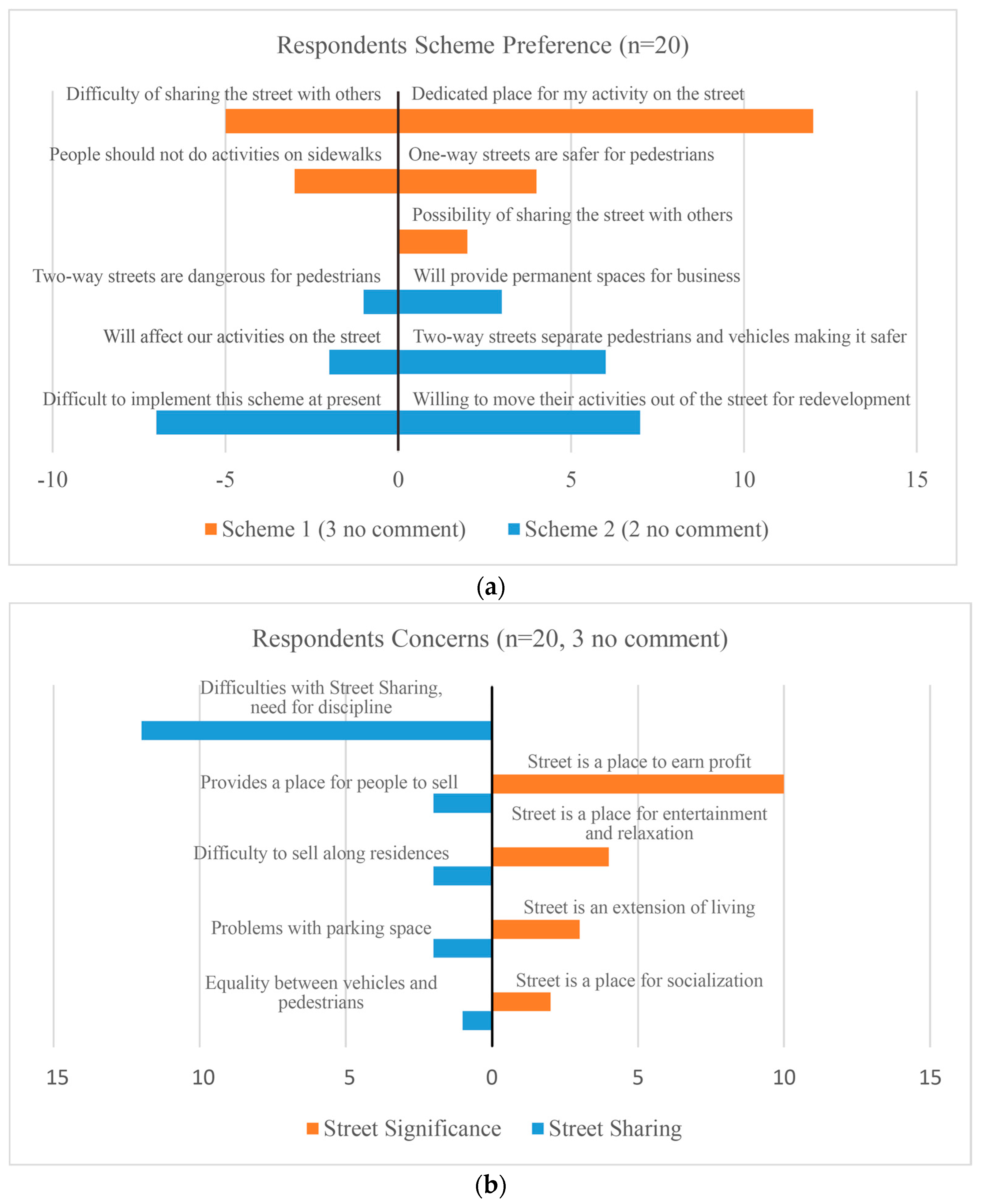
3.5. Interviews with Respondents

3.5.1. Conceptualization of Design Proposals as an Interview Tool

Selected areas along Belgium Street were improved based on the three segments used in the analysis. In segment 3, the rest of the street that leads towards the retail market and the port have similar characteristics with segment 2, which contains the concessionaire market. Hence, there was no need to include this part of the segment in the development of the proposal.
The first scheme applied the results of the analyses by focusing on improvements that preserve the activities based from the behavior settings on the street through street sharing (Figure 9). The street’s width was narrowed to properly set it as a one-way street to prioritize pedestrian over vehicles. Sidewalk elevations were leveled with the carriageway to enhance safety. In addition, the semi-permanent and temporary zones from the analysis were merged together with widened sidewalks, and used different colored pavements to emphasize the zones.
In order to preserve activities along segment 1, the sidewalk along the playground was widened to preserve activities caused by PD behavior settings, such as vendors who sell on the street while accommodating space for pedestrians to walk on. Sitting areas with no backrests were provided for activities based from PT-2 types to make their stay comfortable when they watch games on the playground or choose to watch activities on the street.
Segment 2 provided canopies along its stretch in order to make activities from PD and PSD behavior settings more comfortable. In addition, a time schedule in the sharing of the street was applied on Segment 2 to accommodate the changes in behavior settings throughout the day. During working hours of the markets and shops early in the morning, walkways with the pink colored material were provided for pedestrians to walk in, while the meter gray area was provided for the market and shop owners to occupy for selling, which promotes activities from behavior settings such as PSD-1 and PSD-2 types to occur on the street. When there is little to no activity in the markets and shops are open from the late morning until the early evening, the gray areas can now be occupied by fish vendors who perform activities from PD behavior settings along this street, while the pink area is used for pedestrians to walk through.
Similar to segment 2, time schedules were implemented along segment 3 in order accommodate the behavior settings along this part of the street. During the late evening and early morning, pedestrians occupy the pink area for walking, while the gray areas are allocated for activities from PSD and IG behavior settings. From the late morning until late afternoon, the carriageway reduces its width up to the white strips to accommodate both walking and small vehicles, such as tricycles, to pass through. Behavior settings can then accommodate both the gray and pink area, increasing the area of their activity. Lastly from late afternoon to late evening, the segment becomes closed to vehicles and people and students and coming home from work and school. The occupied areas for activities from PSD and IG behavior settings move back down to the pink area, and the carriageway becomes a playground for the PT-1 type and for pedestrians to walk on (Figure 10).
The second scheme focused on improving the street by widening the carriageway, providing new housing and market facilities, and relocating activities away from the street (Figure 11). The whole stretch of Belgium Street was uniformly widened to accommodate two lanes for vehicles, by taking back some portions of private properties and converting the existing structures into multi-story public housing. The sidewalks were separated from the carriageway using plant strips to protect pedestrians against higher traffic speeds. The street can only be used for vehicular traffic and pedestrian circulation activities such as walking, and all activities will be relocated inside the ground floor of the proposed public housing buildings and in the renovated fish markets.

3.5.2. Results of Interviews

A total sample size of twenty-two respondents, who used the street for a variety of purposes, were interviewed. The quantity of the sample size was mostly female in gender; most respondents were aged 21–64, who mostly lived inside residential blocks that do not face Belgium Street. This indicates that the street is used by other people aside from the residents who live in front of it. With regards to scheme preference, most respondents preferred Scheme 1 over Scheme 2; however, there were 5 respondents who were undecided and had mixed reactions about both schemes and two respondents did not provide any scheme preference (Table 4).
Keywords were extracted from twenty out of the twenty-two respondents who gave comments regarding their comments on different points on both schemes, the significance of Belgium Street to their daily lives, and their opinions on street sharing (Figure 12). The total number of comments for each point do not equal to the corresponding number of respondents because there were some respondents that did not comment, while there were others that gave multiple comments for each point.
Based from the extracted keywords, Scheme 1 was preferred, as it provided dedicated places for their daily activities, was safer for pedestrians as a one way street, and gave them an idea to possibly share the street with others. However, most respondents found Scheme 1 difficult to share the street with others, and did not like people doing activities on sidewalks.
For Scheme 2, most respondents were satisfied with the design, making them willing to adjust their activities for the redevelopment. They also found the street design safer when the two-way implementation separates pedestrians and vehicles; and will provide permanents spaces for business along the street. On the other hand, respondents commented on the difficulty of implementing the scheme at present because of issues, such as affected private properties and the government having difficulty providing such a solution at present. In addition, respondents are afraid of their activities being affected and the design of a two-way street being dangerous to pedestrians.
With regards to respondents’ concerns on street sharing, most found it difficult to implement because of the need to discipline people, difficulties of vendors being able to sell along residences, problems with the lack of parking space causing people to park on the street, the need to establish an equality between pedestrians and vehicles during improvement, and people such as vendors approve of it as it gave places for them to sell along the street. Respondents have also confirmed that the street was significant to their daily lives by being a place for people like vendors and tricycle drivers to make a profit, and get entertained and relaxed, i.e., it is an extension for their living space for residents and for socialization.
Some comments from respondents in Table 5 below were provided to explain additional information to further understand their sentiments regarding the street improvement of Belgium Street. In comments regarding the current situation of their activity and purpose, Scheme 1 was able to provide a place for their activity, thereby preserving behavior settings along the street. Belgium Street contains fish markets along its stretch thereby attracting people to seek opportunities to make a profit. Despite the poor street quality at present, people such as vendors cope with the situation in order to make a profit because of its location. However, if the given the choice, they would want a permanent space back in the market, as proposed in Scheme 2. In addition, open spaces such as parks and playgrounds are needed but are not prioritized for development at present. In the past, there was children’s play equipment on the playground along segment 1, however it was converted exclusively into basketball and volleyball courts when another political administration took over. In addition, the area around Belgium Street contains a dense population of people living in cramped houses attached to each other. These houses are uncomfortable for people, causing them to stay outside on the street.
There have also been concerns with respondents regarding the safety of the street. Belgium Street is supposed to function as a one-way road for delivery trucks exiting from the fish markets; however, the width of Belgium Street is uneven along its stretch. Segments 1 and 2 can provide two lanes, while the stretch along segment 3 can provide only one lane. This influences some drivers to come in from the opposite direction at times. In addition, the sidewalks are being appropriated by people, and part of the street is used for the parking of vehicles on the carriageway. These lessen the clearances for trucks to pass through thereby exposing people to danger.
Regarding their views on street sharing, it was discovered that there were conflicts between people for the use of street space instead of people sharing the street. Although, most respondents stated that Scheme 1 preserved their behavior, they also commented on having difficulty with street sharing because people prioritize their own activities over those of others. On the other hand, Scheme 2 prevents conflict by relocating people’s activities away from the street and inside public housing and renovated fish markets, that diminish the difficulties of compromising with others. Despite the conflicts, there are comments from respondents showing examples of relationships between them and other people which display a sense of street sharing along Belgium Street.

4. Discussion

In this research, the significance of preserving activities can be seen from the behavior settings on Belgium Street which can cause positive impacts on the daily lives of people. The street, despite its poor physical condition, makes up for lack of housing area and public space. However, there is a need to consider how to properly organize and arrange behavior settings on the street during street improvement. It was discovered that sidewalks in this study were used as temporary spaces for the people’s activities aside from being used a circulation space for people to walk on. However, consideration for safety must be given, since people are now left to walk on the street, and are therefore exposed to incoming vehicular traffic. The current situation of street use along Belgium Street has revealed conflicts regarding street use and ownership between its users as opposed to the hypothesis of the street sharing. Street sharing has the potential of instilling a culture that can help change the mindsets of people on how to share the street with others.
There is potential in applying a street type that accommodates temporary uses and behavioral research in streets not only in Philippines, but in cities around the world. Similar to the use of shared streets [36], applying the temporary use of streets for people’s activities will not only promote streets as open spaces for people to use, but can also be used in areas which lack the land area for open spaces. On the other hand, behaviors of people and the use of streets can differ from each country and even from each region, implying that the classification of behavior settings will vary between different environments and culture. Nevertheless, the importance of an environment behavior approach towards the study of streets can improve its physical and functional appearance while preserving people’s activities and culture which in return, promote the development of sustainable cities and communities.
Despite the findings that this research can contribute, it has also come with certain limitations. The amount of time allotted for the survey can be extended to further understand existing behaviors, and discover practices and other behavioral patterns. To improve this limitation, longitudinal studies such as interviewing the respondents with regards to the change of behavior on the street over time or living in the area can help one to understand the behavior of people in a certain area. Difficulties with behavior mapping, such as mapping overlays manually and the difficulties of having interviews with respondents, can be improved with the use of methods such as the using GIS and other participatory software [17,31], which can aid in the gathering of qualitative and quantitative data for analysis. In addition, consultations with experts, professionals, and related non-profit organizations, and gathering their ideas through cognitive mapping [37], can help map out certain considerations needed for the design and successful implementation of street improvement and research.
Future studies for this research can include the expansion of the research scope by studying people’s stationary behavior on street networks and their connections to other green spaces, people’s homes and other institutions, in order to promote proper connectivity between these public and private spaces. In addition, comparative studies of the behavior on streets can be done in different countries to determine street improvements, and based on this research, can be exported to other cities in the world.

5. Conclusions

This research studies the behavior settings and their relationships with the physical environment of Belgium Street in Cebu city, Philippines and concludes the following:
(1)
Four classifications of behavior settings and their types that helped describe Filipino behavior were discovered on the street. These behavior settings give an understanding as to how the street serves its purpose of providing people a means of socialization (IG), relaxation (PSD), an opportunity to make profit (PD), and gather around activities of interest (PT). In addition, the use of classifying behavior settings can help quantify existing behaviors on streets for analysis.
(2)
Utilizing streets as a space which accommodates temporary uses that preserve people’s behaviors further strengthening its role as a public space, filling the need for providing open space while being able to accommodate vehicular traffic.
(3)
The discovery of a series of zones on the use of the street that accommodate permanent structures (permanent zone); activities, vending stalls and furniture (semi-permanent zone); activities, walking, lightweight furniture, parking space (temporary zone); and circulation for vehicles and pedestrians (transit zone) can be applied in the improvement of other streets with similar characteristics.
Conclusions can be used to promote design solutions for the temporary uses on streets while considering adjustments across twenty-four hours, based on the discovered behavior settings, while considering the preservation of people’s activities, promotion of safety, and prevention of conflicts between behaviors and vehicular traffic that can be applied to similar kinds of streets experiencing similar situations.

Supplementary Materials

The following are available online at https://www.mdpi.com/2071-1050/10/9/3230/s1.

Author Contributions

Conceptualization, S.M. and J.M.E.; Investigation and Data Curation, J.M.E.; Analysis, J.M.E.; Methodology, S.M., R.N. and J.M.E.; Supervision, S.M. and R.N.; Validation, S.M.; Writing—original draft, J.M.E.; Writing—review and editing, J.M.E.

Acknowledgments

The author extends his gratitude towards the Japanese Government (MEXT) Scholarship Program for the opportunity to pursue graduate studies and this research. Sincerest of thanks to the author’s supervisor, Professor Suguru Mori for providing additional financial support for the transportation expenses of this research.

Conflicts of Interest

The authors declare no conflict of interest.

References

  1. Park, S. A preliminary study on connectivity and perceived values of community green spaces. Sustainability 2017, 9, 692. [Google Scholar] [CrossRef]
  2. Kim, S.; Kwon, H. Urban sustainability through public architecture. Sustainability 2018, 10, 1249. [Google Scholar] [CrossRef]
  3. Jacobs, J. The Death and Life of Great American Cities; Random House: New York, NY, USA, 1961. [Google Scholar]
  4. Lynch, K. The Image of the City; MIT Press: New York, NY, USA, 1960. [Google Scholar]
  5. Hassen, N.; Kaufman, P. Examining the role of urban street design in enhancing community engagement: A literature review. Health Place 2016, 41, 119–132. [Google Scholar] [CrossRef] [PubMed]
  6. Gehl, J. Life between Buildings—Using Public Space; Van Nostrand Reinhold: New York, NY, USA, 1987. [Google Scholar]
  7. Carmona, M.; Heath, T.; Oc, T.; Tiesdell, S. Public Places–Urban Spaces; Architectural Press: Abingdon, UK, 2003. [Google Scholar]
  8. Metha, V. Determining environmental characteristics to support social behavior. J. Plan. Educ. 2007, 27, 165–187. [Google Scholar]
  9. Carmona, M. London’s local high streets: The problems, potential and complexities of mixed street corridors. Prog. Plan. 2015, 100, 1–84. [Google Scholar] [CrossRef]
  10. Barton, H. Land use planning and health and well-being. Land Use Policy 2009, 26S, S115–S123. [Google Scholar] [CrossRef]
  11. Oranratmanee, R.; Sachakul, V. Streets as public spaces in southeast Asia: Case of Thai pedestrian streets. J. Urban Des. 2014, 19, 211–229. [Google Scholar] [CrossRef]
  12. Appleyard, D. Streets can kill cities: Third world beware—Guidelines for street design in third world cities. Habitat Int. 1983, 7, 111–122. [Google Scholar] [CrossRef]
  13. Dela Paz, F.I. Savouring the streets of Sampaloc: Rediscovering its local flavour. In On Asian Streets and Public Space; Heng, C.K., Low, B.L., Hee, L., Eds.; NUS Press Pte Ltd.: Singapore, 2009; pp. 93–104. [Google Scholar]
  14. Drummond, L. Street scenes: Practices of public and private space in urban Vietnam. Urban Stud. 2000, 37, 2377–2391. [Google Scholar] [CrossRef]
  15. Mojares, R. Dakbayan: A cultural history of space in a Visayan City. Philipp. Q. Cult. Soc. 1999, 27, 117–132. [Google Scholar]
  16. Connel, J. Beyond Manila: Walls, malls and private spaces. Environ. Plan. A 1999, 31, 417–439. [Google Scholar] [CrossRef]
  17. Brown, G.; Rhodes, J.; Dade, M. An evaluation of participatory mapping methods to assess urban park benefits. Landsc. Urban Plan. 2018, 178, 18–31. [Google Scholar] [CrossRef]
  18. Garcia-Ayllon, S. Rapid development as a factor of imbalance in urban growth of cities in Latin America: A perspective based on territorial indicators. Habitat Int. 2016, 58, 127–142. [Google Scholar] [CrossRef]
  19. Gonzales, Y.V. PH Cities Lack ‘Visual Harmony,’ Walkable Streets, Says Expert. Available online: http://newsinfo.inquirer.net/737498/ph-cities-lack-visual-harmony-walkable-streets-says-expert (accessed on 20 July 2017).
  20. Philstar Global. Too Many Malls, Not Enough Parks. Available online: https://www.philstar.com/business/2016/12/05/1650279/too-many-malls-not-enough-parks (accessed on 20 July 2017).
  21. Business Mirror. Time to Think, Talk about Green Space. Available online: https://businessmirror.com.ph/time-to-think-talk-about-green-space/ (accessed on 20 July 2017).
  22. Cebu Daily News. Green Spaces and Metro Cebu. Available online: http://cebudailynews.inquirer.net/148905/green-spaces-metro-cebu (accessed on 5 October 2017).
  23. The Manila Times. Parks and Open Spaces. Available online: http://www.manilatimes.net/parks-and-open-spaces/171938/ (accessed on 20 July 2017).
  24. Iloilo Metropolitan Times. Walk Along the Esplanade and Experience Outdoor Environment. Available online: http://www.iloilometropolitantimes.com/walk-along-the-esplanade-and-experience-outdoor-environment/ (accessed on 16 July 2018).
  25. JICA. The Roadmap Study for Sustainable Urban Development in Metro Cebu. Available online: https://www.jica.go.jp/philippine/english/office/topics/news/c8h0vm00009pqw0q-att/151102_01.pdf (accessed on 18 April 2016).
  26. Rappler. Road Sharing to Take Place in 4 Cebu City Roads. Available online: https://www.rappler.com/science-nature/society-culture/70292-road-sharing-cebu-city-roads (accessed on 18 April 2016).
  27. Sunstar Philippines. No More Drinking in Public Places Soon. Available online: https://www.sunstar.com.ph/article/422282/No-more-drinking-in-public-spaces-soon (accessed on 16 July 2018).
  28. Philstar Global. Anti-tambay Crackdown Nets 7291 in Metro Manila. Available online: https://www.philstar.com/headlines/2018/06/21/1826575/anti-tambay-crackdown-nets-7291-metro-manila (accessed on 16 July 2018).
  29. CNN Philippines. Senator Bam Aquino, House Lawmakers, Seek Probe of Anti-tambay Policy. Available online: http://cnnphilippines.com/news/2018/06/25/Duterte-PNP-tambay-arrest-Senate-House-investigation-Bam-Aquino.html (accessed on 16 July 2018).
  30. Siu, K. Guerilla wars in everyday public spaces: Reflections and inspirations for designers. Int. J. Des. 2007, 1, 37–56. [Google Scholar]
  31. Panek, J.; Benediktsson, K. Emotional mapping and its participatory potential: Opinions about cycling conditions in Reykjavik, Iceland. Cities 2017, 61, 65–73. [Google Scholar] [CrossRef]
  32. Serra-Coch, G.; Chastel, C.; Campos, S.; Coch, H. Graphical approach to assess urban quality: Mapping walkability based on the TOD-standard. Cities 2018, 76, 58–71. [Google Scholar] [CrossRef]
  33. Project for Public Spaces. How to Turn a Place Around: A Handbook for Creating Successful Public Spaces; Project for Public Spaces: New York, NY, USA, 2000. [Google Scholar]
  34. Barker, R. Ecological Psychology: Concepts and Methods for Studying the Environment and Human Behavior; Stanford University Press: Stanford, CA, USA, 1968. [Google Scholar]
  35. Schoggen, P. Behavior Settings: A Revision and Extension of Roger G. Barker’s Ecological Psychology; Stanford University Press: Stanford, CA, USA, 1989. [Google Scholar]
  36. World Resources Institute. Cities safer by design: Guide and Examples to Promote Traffic Safety through Urban and Street Design. Available online: https://www.wri.org/sites/default/files/CitiesSaferByDesign_final.pdf (accessed on 10 May 2018).
  37. Faria, P.; Ferreira, F.; Jalali, M.; Bento, P.; Antonio, N. Combining cognitive mapping and MCDA for improving quality of life in urban areas. Cities 2018, 78, 116–127. [Google Scholar] [CrossRef]
Figure 1. Use of Street Space in the Philippines.
Sustainability 10 03230 g001
Figure 2. Location and Existing Conditions of Belgium Street.
Sustainability 10 03230 g002
Figure 3. Behavior Mapping Route for Belgium Street.
Sustainability 10 03230 g003
Figure 4. Consolidation of All Recorded Activities on Belgium Street.
Sustainability 10 03230 g004
Figure 5. Location of Behavior Settings along Belgium Street.
Sustainability 10 03230 g005
Figure 6. (a) Appropriations on the street caused by the lack of space; (b) Sidewalk Discontinuity created unused spaces on the street that were occupied by others; (c) Sports on the Playground become events that attract behavior settings.
Sustainability 10 03230 g006
Figure 7. Movement of Behavior Settings along Belgium Street.
Sustainability 10 03230 g007
Figure 8. Street Use Zones of Belgium Street.
Sustainability 10 03230 g008
Figure 9. Scheme 1 for the Proposal for Street Improvement.
Sustainability 10 03230 g009
Figure 10. Street Use at Different Times along Segment 3.
Sustainability 10 03230 g010
Figure 11. Scheme 2 for the Proposal for Street Improvement.
Sustainability 10 03230 g011
Figure 12. Responses regarding: (a) Scheme Preference and (b) Street sharing and Street Significance.
Sustainability 10 03230 g012
Table 1. Details of Research Area (from Philippine Statistics Authority and Cebu City Planning Office and Site Survey).
Area NameBarangay Suba
LocationCebu City South District
Population11,026 (as of 2015)
Percentage of Elderly0.05%
Household1766 (as of 2000)
Persons per Household4.69 (as of 2000)
Street NameBelgium Street
ClassificationCity Road
Length350 m
WidthVaries (from 6 m to 10 m)
MaterialReinforced Concrete and Asphalt
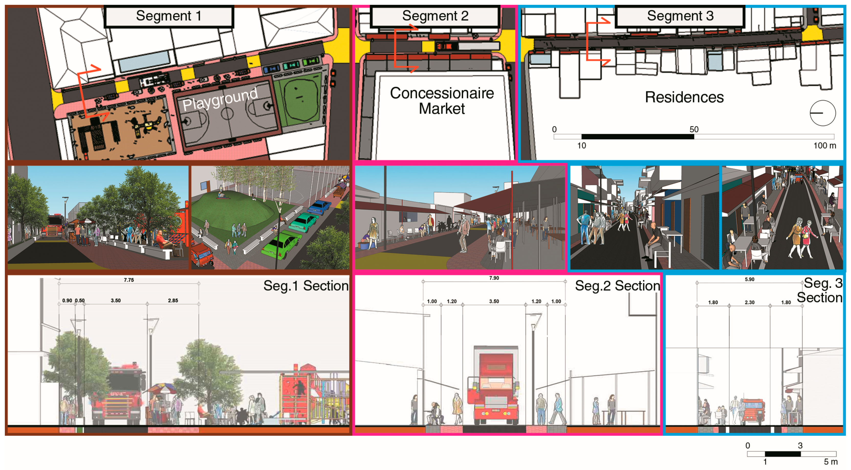
Structures and Amenities along Belgium StreetResidences, Commercial Buildings, Playground, Concessionaire and Retail Fish Markets, Passenger Port
Construction MaterialReinforced Concrete, Light Materials
Height of Structures1–6 stories
Proposed Expansion of Belgium StreetProposed Widening: 12 mPlant Strips: 0.60 mSidewalk (One Side): 2 mSidewalk Classification: Arcaded
Table 2. Classification of Behavior Settings on Belgium Street.
Istambay sa Gawas (IG) To socialize with others on the street
Sustainability 10 03230 i001
IG-1: In a Private Meeting
Sustainability 10 03230 i002
IG-2: Around the Family Circle
Pahangin sa Dalan (PSD) To use the street as a place to relax
Sustainability 10 03230 i003
PSD-1: Alfresco Dining
Sustainability 10 03230 i004
PSD-2: Idling Around
Sustainability 10 03230 i005
PSD-3: Blending with the Streetscape
Patagad (PD) To seek attention from others to earn a profit
Sustainability 10 03230 i006 Sustainability 10 03230 i007
Pagtapok (PT) To crowd around an activity of interest
Sustainability 10 03230 i008
PT-1: Little Adventures
Sustainability 10 03230 i009
PT-2: Being one with the Crowd
Table 3. Quantities of Behavior Settings.
WeekdaysBehavior SettingsWeekends
4:00–5:008:00–9:0013:00–14:0016:00–17:0020:00–21:00Total/TypeTotal/Type4:00–5:008:00–9:0013:00–14:0016:00–17:0020:00–21:00
PSD
121204432PSD-122102460
2435385430181PSD-21911830237743
10124017PSD-3703211
IG
3505518IG-11920386
0191825769IG-282021182617
PT
001325442PT-1630275283
05018932PT-229019190
PD
1624202713100-1001025173414
651019116272491Total/Day513401098119984
Table 4. Characteristics of Respondents.
Total Number of Respondents = 22
Gender
Male10 personsFemale12 persons
Age
Below 20 years1 person21–64 years20 personsAbove 65 years1 person
Location of Residences
In front of the Street7 personsInside the residential blocks.13 personsNot from Barangay. Suba2 persons
Types of Respondents
Mobile Vendors2 personsVendors3 personsTricycle Drivers1 person
Residents9 personsCustomers2 personsBystanders5 persons
Scheme Preference
Scheme 19 personsScheme 26 personsUndecided5 persons
Table 5. Comments from Respondents.
ConcernRespondent, Age, GenderComment
Explanation on the current situation of their activity and purposeVendor, Female, 40 years oldPrefers a permanent place to sell (i.e., in the market) instead of looking for a place to sell on the street daily.
Bystander, Male, 70 years oldReason for staying outside the street is because of poor housing conditions.
Explanation on their views of Street SafetyBystander, Male, 17 years oldPrefers the first scheme because it is more organized and suggests better enforcement and installing signs to properly identify the street as having a one-way traffic scheme.
Customer, Female, 38 years oldPrefers children not to play on the street because vehicular accidents involving children have happened before.
Customer, Female, 40 years oldSidewalks are not used for pedestrians but for storing items. Vehicles such as tricycles occupy the street making it more cramped and difficult for fire engines to pass through which caused an accident.
Explanation on their views of Street SharingVendor, Female, 29 years oldPrefers locating herself on the road where customers can find her. Dislikes the idea of street sharing, and is more focused on earning a profit.
Resident, Female, 42 years oldPeople are focused on their own personal matters, prioritizing themselves over others. Prefers removing activities from the street because conflicts happen between residents and people who occupy the street.
Resident, Female, 41 years old *Shares the street with her neighbor across by occupying the front of his house when it is hot and vice-versa. Does not occupy front of her house because she understands the street is a public domain shared by everyone.
Resident, Female, 43 years old *Shares the front of her house with street vendors, who in return, clean up after use and sometimes watch over house when she is away.
Respondents with an * did not provide additional comments regarding scheme preference, street sharing, and significance.

