Article

Geometrical and Functional Criteria as a Methodological Approach to Implement a New Cycle Path in an Existing Urban Road Network: A Case Study in Rome

Department of Civil, Construction and Environmental Engineering, Sapienza University of Rome, Rome 00184, Italy
*
Author to whom correspondence should be addressed.
Sustainability 2018, 10(8), 2951; https://doi.org/10.3390/su10082951
Submission received: 4 July 2018 / Revised: 9 August 2018 / Accepted: 16 August 2018 / Published: 20 August 2018

Abstract

:
Most road accidents occur in urban areas and notably at urban intersections, where cyclists and motorcyclists are the most vulnerable. In the last few years, cycling mobility has been growing; therefore, bike infrastructures should be designed to encourage this type of mobility and reduce motorized and/or private transport. The paper presents a study to implement a new cycle path in the existing cycle and road network in Rome, Italy. The geometric design of the new path complies with Italian standards regarding the technical characteristics of bicycle paths, while the Highway Capacity Manual has been considered for the traffic analysis. In particular, a before-after approach has been adopted to examine and compare the traffic flow at more complex and congested intersections where the cycle path will pass. Trams, buses, cars, bikes and pedestrians were the traffic components considered in each analysis. The software package PTV VISSIM 8 allowed the simulations of traffic flows at traffic-light intersections; an original linear process has been proposed to model dynamic intelligent traffic controls, which are not admitted by the software used. The traffic analysis allowed the identification of the best option for each of the five examined intersections. Particularly, the maximum queue length value and the total number of passed vehicles have been considered in order to optimize the transport planning process. The results of this study highlight the importance of providing engineered solutions when a cycle path is implemented in a complex road network, in order to avoid negative impacts on the citizens and maximize the expected advantages.

1. Introduction

User safety is one of the most important issues in road design. The Organization for Economic Co-operation and Development (OECD) demonstrated that in the last two decades, the trend of road accidents is not positive all over the world [1]. Statistical data highlight that there are states where the number of deaths and injuries is growing, especially for developing countries (e.g., India, Armenia, Bosnia and Herzegovina) and the most vulnerable users [2].
A non-negligible rate of road accidents (73% in Italy according to Canale et al. [3]) occurs in urban areas, where externalities of motorized traffic (e.g., congestion and pollution) encourage the use of “soft mobility”. In the literature, several studies demonstrated that cyclists and motorcyclists are the most vulnerable in urban areas [4,5,6,7]. However, cycling mobility should be encouraged in busy urban areas because it ensures several advantages:
  • health-related: continuous and regular use of bicycles supports daily exercise [8,9];
  • economic aspect: it reduces the part of the family budget allocated to a car, but also the hours lost in traffic, especially city traffic;
  • ecological: it implies less environmental impact and zero pollution, both atmospheric and acoustic [8];
  • political aspects: it permits reducing energy dependence and saving non-renewable resources;
  • mobility: the systematic reduction of private motor vehicles favors public transport; in this perspective, the benefits of modal split can be fully exploited, resulting from the decrease in the number of cars in circulation [10];
  • social: it leads to increased autonomy of young and elderly people [11];
  • psychic: it results in stress reduction.
Moreover, bikes’ infrastructures could meet significant challenges in the urban environment:
  • geometrical characteristics should be compliant with the physical conditions of users (e.g., plano-altimetric characteristics of the cycle path should guarantee the user comfort in order to encourage the use of the infrastructure; the longitudinal slope should be minimized);
  • especially at road intersections, conflict points with other road users should be avoided and minimized [12];
  • the continuity of cycle paths should be guaranteed;
  • horizontal and vertical signs should be correct and clear in order to have safe and regular traffic conditions (e.g., unclear signs may cause discomfort, confusion, accidents or traffic infractions [13]);
  • paths should be secure, functional and correctly set within the existing framework: a sustainable pavement management system [14] could improve users’ safety.
Transportation planning should consider this type of mobility in order to boost a systematic decline of private cars that generate congestion and other externalities [15]. The urban modal split should be planned in the travel simulation process without overlooking individual, environmental and infrastructural chief factors that influence the decision to bicycle [16]. Perceived safety is one of the most important factors for the modal split to bikes, but also the organization of cycle traffic and cycle infrastructures influence the behavior of road users [17]. Indeed, the lack or inadequacy of transport infrastructures results in a barrier to cycling [18]. It is therefore necessary to design roads conceived for cyclists.
The “Guide for the development of bicycle facilities” prepared by the American Association of State Highway and Transportation Officials (AASHTO) task force on geometric design states that all roads, except those where cyclists are legally prohibited, should be designed and constructed under the assumption that they will be used by cyclists [19]. The Spanish technical book “La bicicleta en la ciudad” focuses on urban infrastructures reserved to cyclists [20]: bikes are recognized as a transport mode that meets the European goal of boosting sustainable transport systems [21].
Therefore, bicycles should be considered in all phases of the design and rehabilitation of transport infrastructures: as regards the urban environment [22,23], different solutions are available. The Danish Roads Directorate acknowledges that the cycle track system works better when cyclists travel at relatively low speeds [24]. Furthermore, bicycle lanes are ideal for urban areas, where traffic speed is no more than 50 km/h and traffic volume is modest. Different categories of bicycle user exist (e.g., workers, children, elderly people and tourists); therefore, the path should avoid excessive slopes and interferences with motor vehicles. Signalized intersections and a proper lighting system are recommended to ensure the regular and safe use of roads.
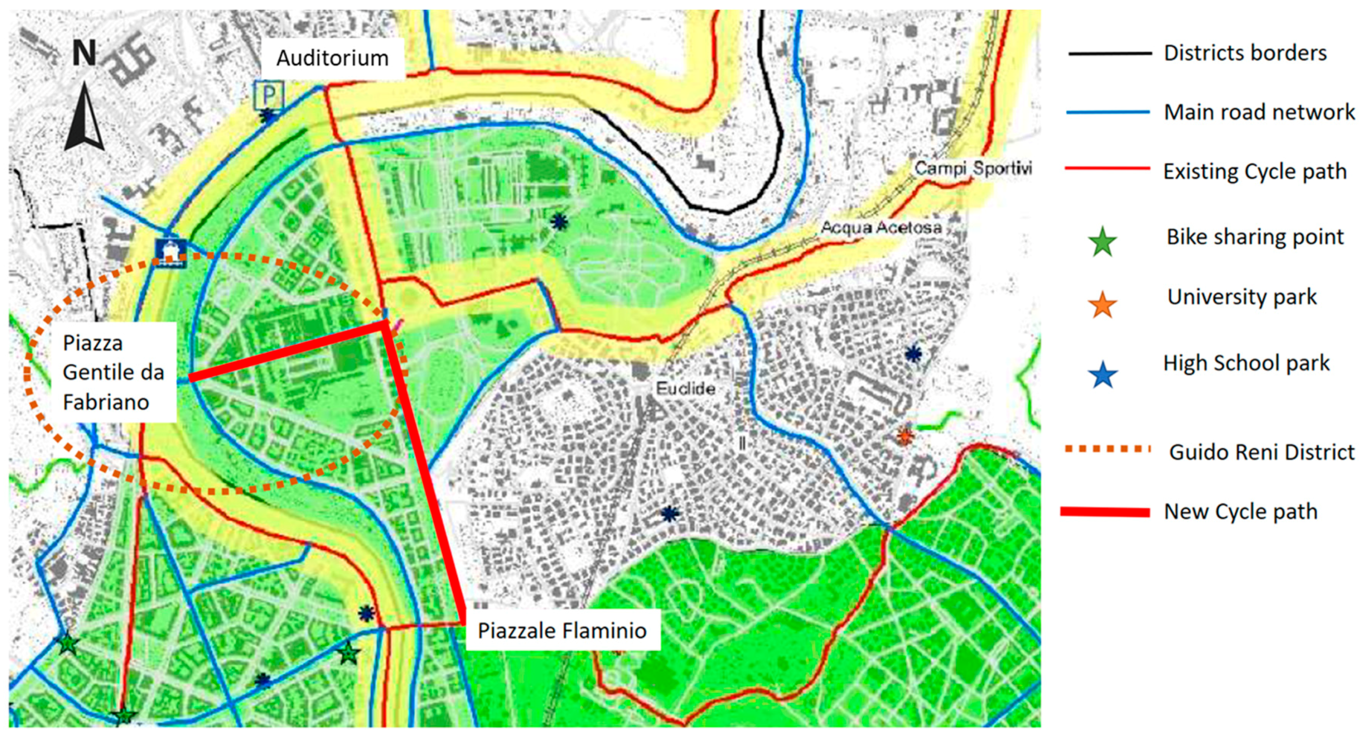
The paper presents the study to implement a cycle path inside Rome’s municipality, the functional bicycle network of which is not complete yet. The existing network is composed of routes that are not defined as cycle paths, but they link different corridors: the new bicycle corridor will enhance bike mobility and will connect two existing corridors. Trams, buses, cars and pedestrians are the traffic components considered in the analysis: the goal of the study is to maintain a continuous path balancing often conflicting objectives and needs for urban mobility.

2. Data and Methods

The new cycle path to be designed will be in the northeast part of Rome’s municipality (Italy), where the Guido Reni district is. The study involves a new L-shaped bicycle route, which is provided by the cycling framework of the Roma Capitale administration. Guido Reni district is located in an historical area of Rome, where the urban framework constrains urban traffic development. Blue and red lines in Figure 1 represent the existing functional network: it is composed of roads and cycle paths, respectively.
The design process of the new path took into account geometrical, functional and technical criteria:
  • to minimize the conflict points between road users [25,26]. Several studies in the literature have demonstrated that cyclists and motorcyclists are the most vulnerable in urban areas [4,6]. Moreover, Isaksson-Hellman and Werneke [27] demonstrated that over than 70% of accidents that involve cyclists occur at road intersections. Therefore, in the present study, the goal is to avoid the trajectories of different users interfering;
  • to remove the least number of existing parking lots. Parking spaces play a critical role in the mobility in Rome [28]. The parking system currently works at capacity; therefore, a reduction of available lots should be minimized to contain the impact on citizens;
  • to design shared pathways for bike and pedestrian traffic when geometrical and functional conditions do not permit designing a cycle path. Shared areas are currently designed around the world, where different road users share the road space [29,30], but they are not widespread and appreciated in Italy;
  • to reduce the interaction with common urban activities (e.g., markets, haunts and sites of public offices). For a transport infrastructure, the level of service depends on its regular accessibility and viability: the presence of access point for public services can affect the circulation and induce incorrect and hazardous maneuvers of cyclists;
  • to increase the use of bikes and to encourage multimodality. The L-shaped route will improve the role of Piazzale Flaminio as a multimodal node, where buses, metro and regional railway pass;
  • to choose the shortest and safest routes, reducing the cyclists’ exposure time to the collision risk. The estimation of the exposure time to the collision risk is a method proposed by Elvik et al. [31] to identify the most dangerous maneuvers at urban intersections;
  • to improve the quality of service, analyzing the impact of bikes’ flow on vehicular traffic in terms of queues and emissions to the air. For this purpose, the authors used the commercial microscopic simulation package PTV VISSIM 8 [32] to simulate the flow in the most complex intersections considering the background maps and the existing traffic volume and its composition (cars, moped, vans, buses and heavy commercial vehicles). Particularly, PTV VISSIM 8 has been used because it provides simulations close to the real situation, especially when large intersections, complex geometries, buses and trams should be considered [33].
    The Highway Capacity Manual [34] suggests performing 15 min-long traffic counts during a significant period of time in a year. In the present study, all the surveys were conducted in May, when in Rome, the weather condition is not an obstacle to movements and all work- and school-related activities are ongoing. First, for each intersection, a base simulation model was developed and calibrated to represent field conditions [35]. The geometry of each intersection was drawn in VISSIM, and fundamental simulation model parameters were defined based on field data (e.g., traffic volume/turning movements, traffic composition, priority rules, traffic signs). Vehicles’ acceleration, desired speed, clearance speed, lane change distance and minimum headway are parameters adjusted to replicate the observed traffic conditions [36,37]. Then, for each intersection, modified simulation models were developed including a modification required by the new cycle path. The output data of the simulation provide several indices: the average total delay per vehicle, the average standstill time per vehicle, the average number of stops per vehicle, the vehicle number throughput, the maximum queue length, the emissions to the air in terms of CO, NOx and VOC and the fuel consumption.
In the present study, the authors defined a new bike path to enhance the existing cycle network. Piazza Gentile da Fabriano and Piazzale Flaminio are respectively the starting and the ending points of the new cycle path, whose mixed lanes will be minimized.
Table 1 lists geometric characteristics and the design bicycle traffic of the path. The geometric constraints comply with the Italian standard regarding the technical characteristics of bicycle paths [38]. However, the adopted geometric limits are comparable to those prescribed by [19,20,24]: in this study, the most significant results are not affected by the reference standard. However, Spanish, Danish and American regulations contributed to defining the technical details to manage bike flows at intersections.
The path will be located in the Guido Reni district (dotted brown circle in Figure 1). The area is currently affected by an observed intense volume of bicycle traffic, the scope of which is both work and pleasure. The traffic analyses resulting from PTV VISSIM 8 (hereafter ‘VISSIM’) enabled the comparison of different alternatives for each complex intersection in order to define the geometric and technical characteristics of the path. The maximum queue length value has been considered as an indicator that is useful to assess the congestion degree and choose the best alternative.

3. Results

The designed new path is mostly flat and 2.6 km long, on which cyclists can ride without any interruption, excluding traffic lights and unpredictable events.
The designed proposal complies with the approach adopted by several cities around the world (e.g., Paris, Thessaloniki, Barcelona, Medellin) [39,40,41,42,43,44], where the hierarchies of transport modes are: public transport and bikes are respectively favored over private cars in order to have environmental and social benefits [45,46].
Figure 2 represents an overview of the new cycle path.
Each number in Figure 2 represents a different cross-section (Figure 3, Figure 4, Figure 5, Figure 6, Figure 7, Figure 8, Figure 9 and Figure 10). All the proposed cross-sections comply with the Italian standards about the technical characteristics of bicycle paths [38], and they have been adapted to the existing road network.
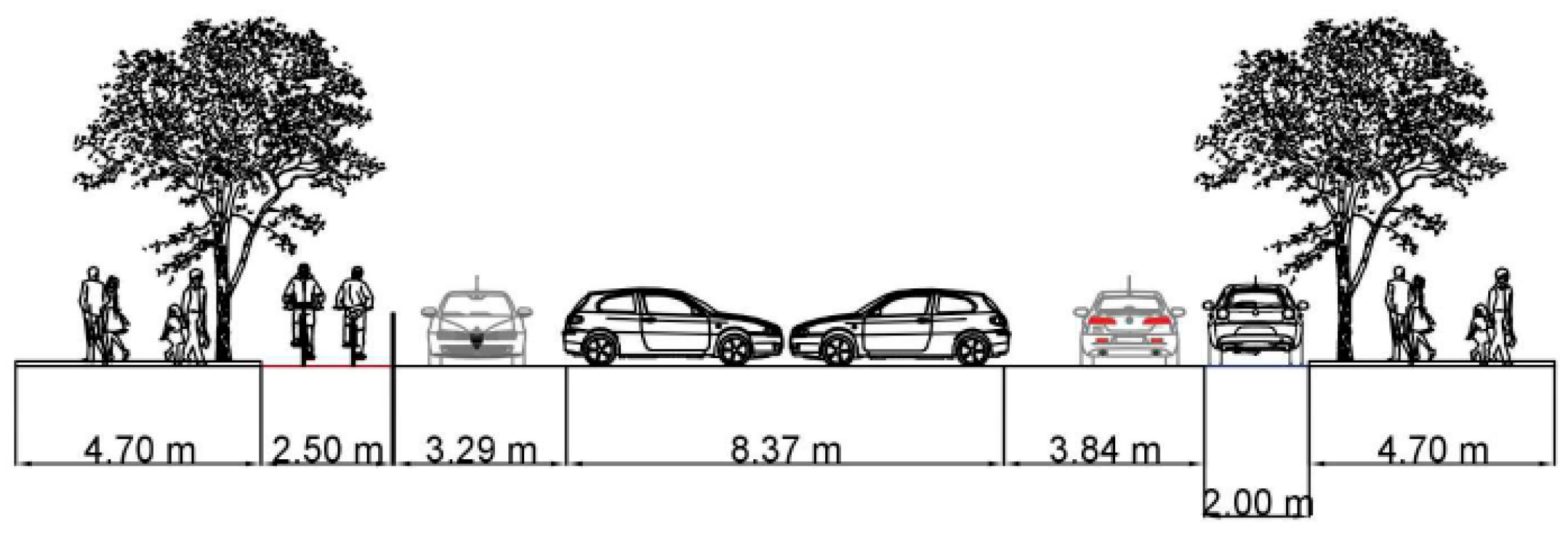
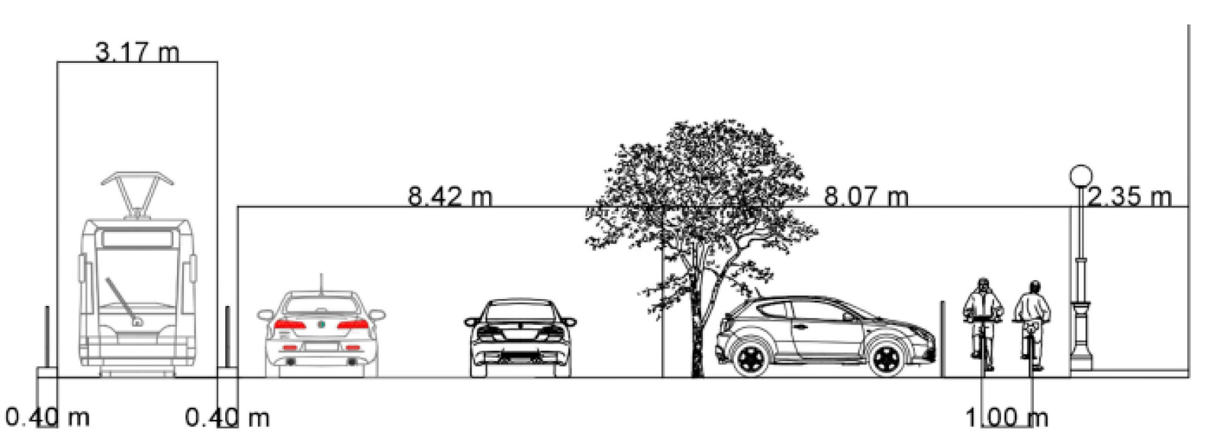
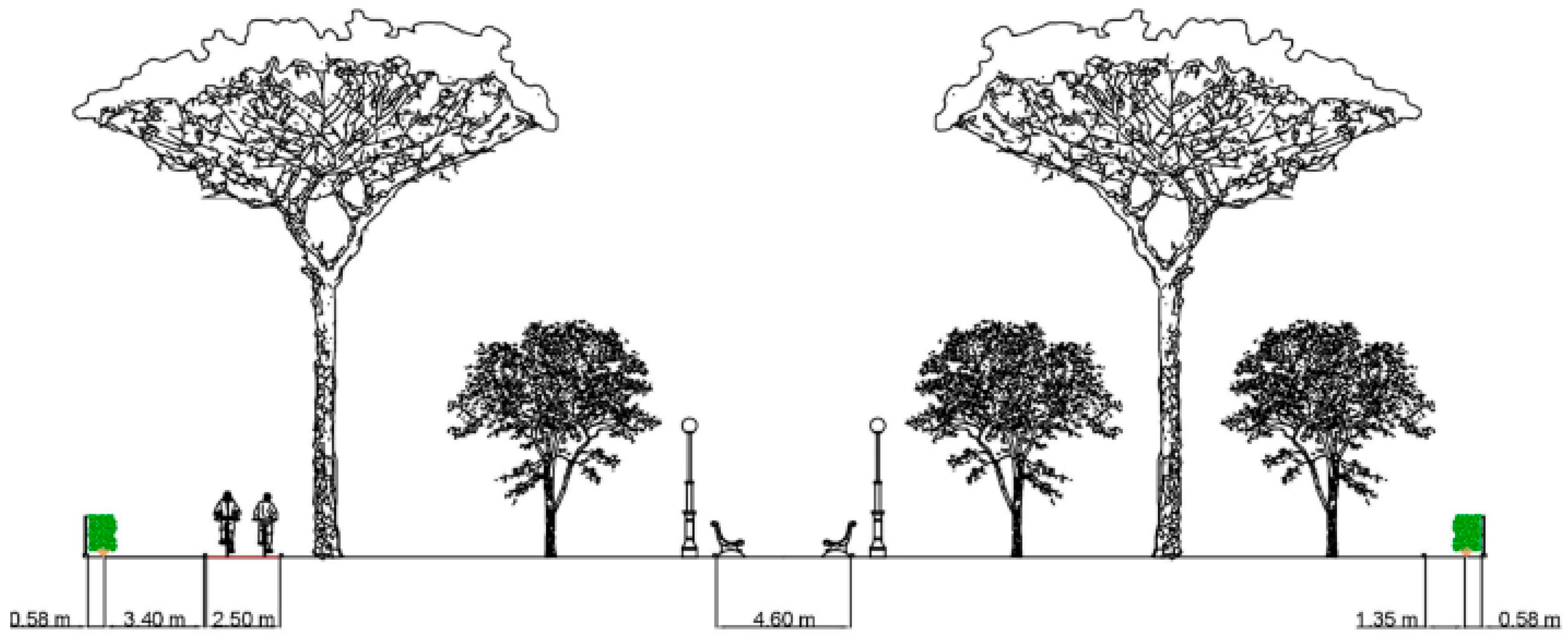
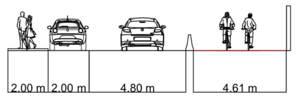
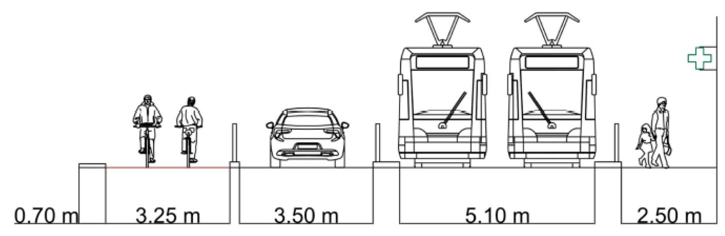
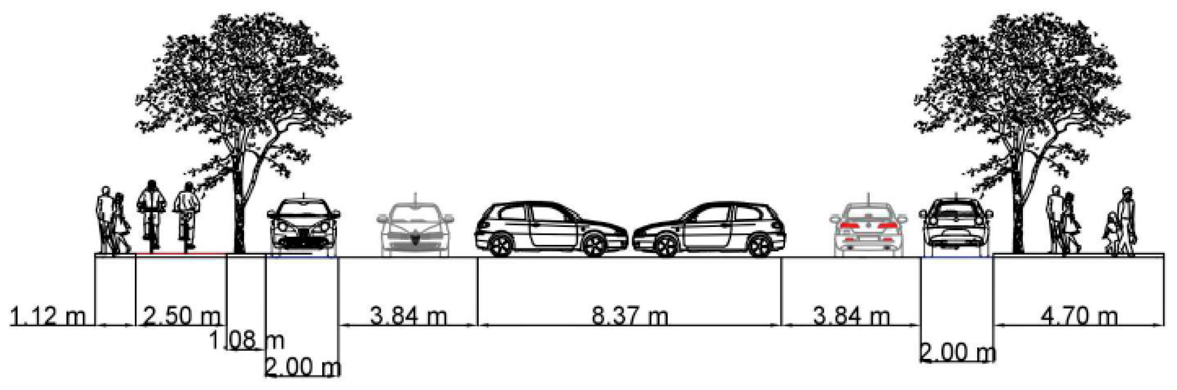
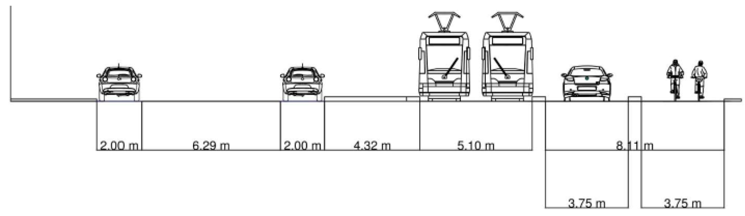
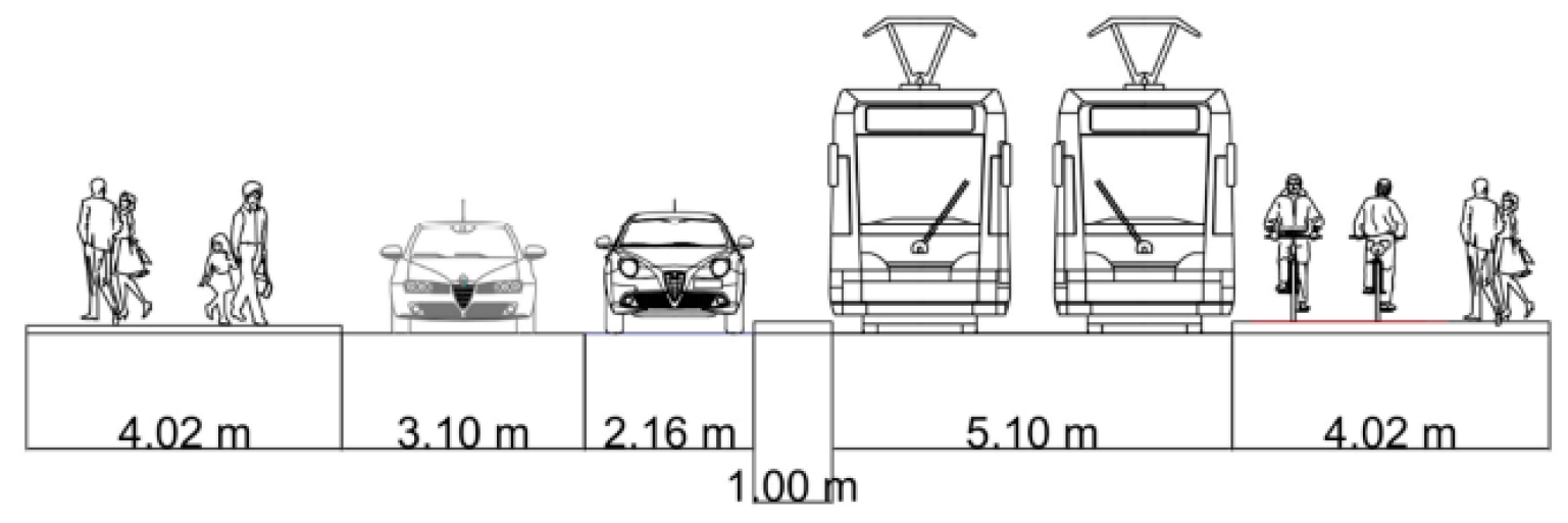
Table 2 lists the geometrical and technical characteristics of the designed cross-sections.
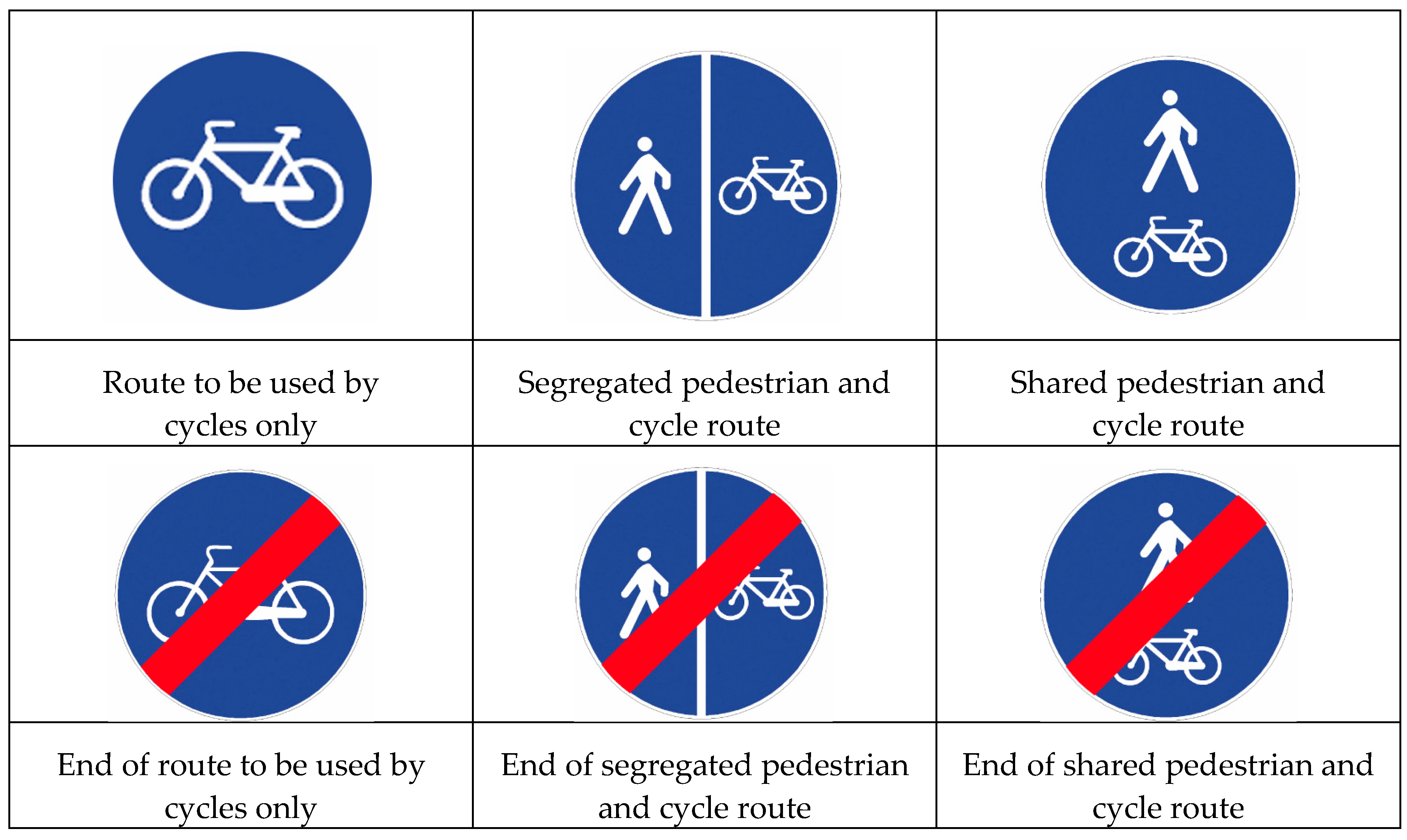
Visual distinctions of the cycle path have been provided for branches shared with pedestrians: red-colored asphalt is planned. According to [38], markings and vertical signs represented in Figure 11 provide guidance for disciplined and safe circulation.
Full length bicycle lanes combined with shared areas for straight traffic and right-turning vehicles have been designed at intersections [12]: this layout has been chosen because it is well known by Italian road users. Moreover, it provides a good level of safety for cyclists [12] at the designed traffic volume, and it does not require important modifications of the existing intersection layout.
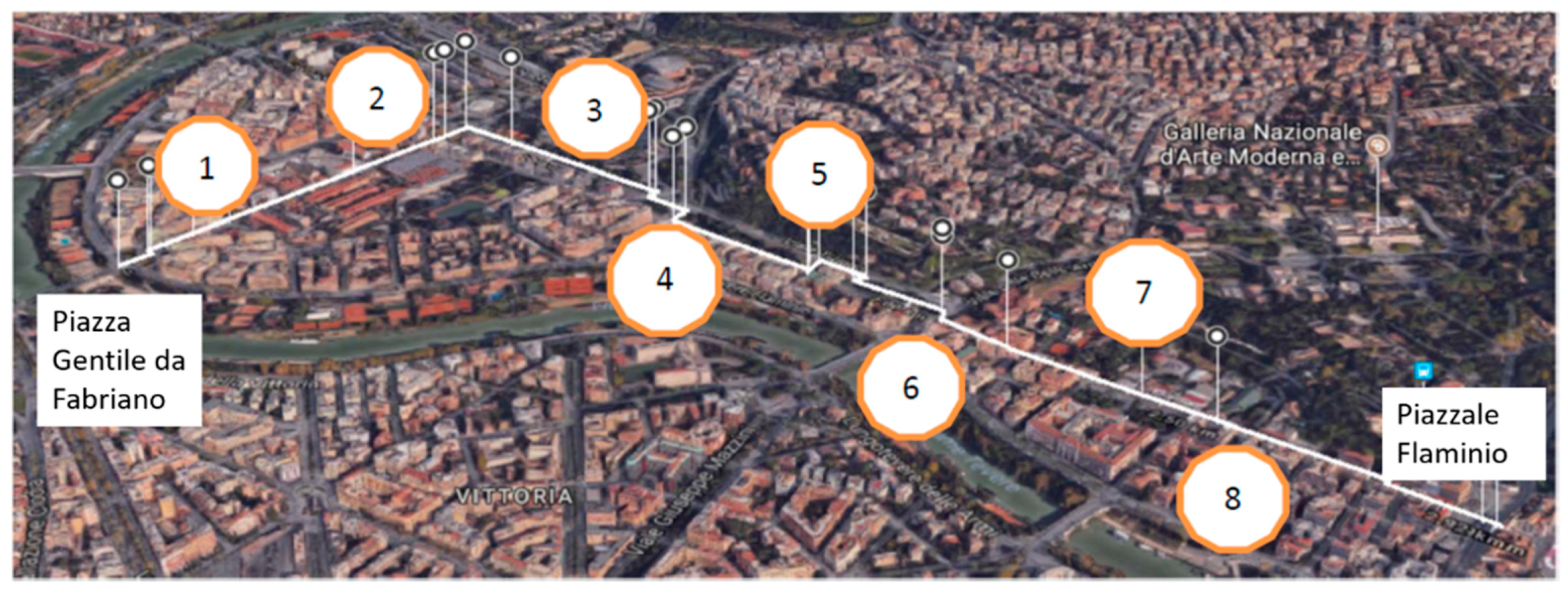
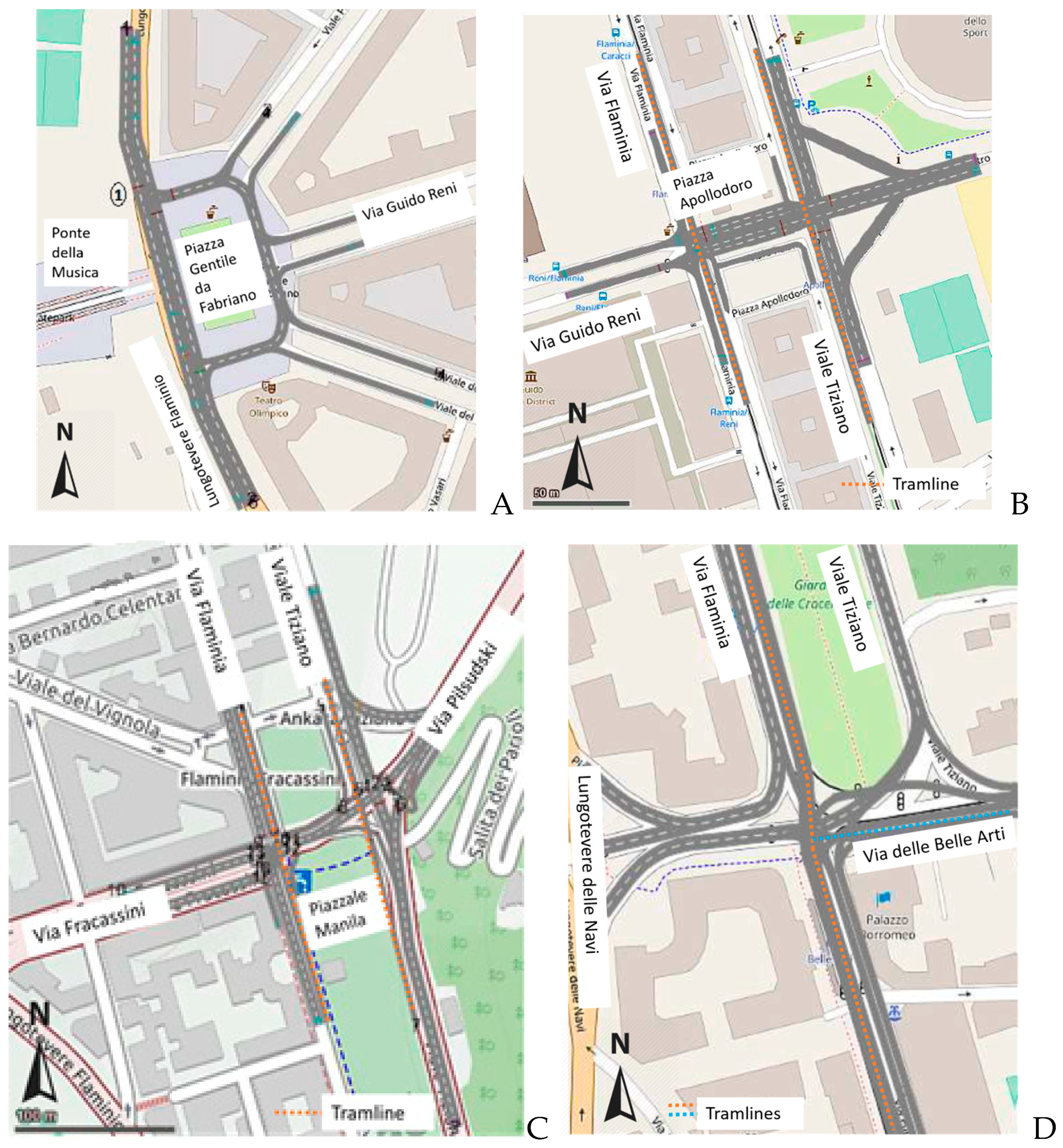
As regards the traffic pattern, each intersection of the project has been analyzed through a before-after approach on the existing and the modified road network. In this study, the authors present the most interesting and critical nodes, where cyclists have to perform crucial and dangerous maneuvers. They are represented in Figure 12:
  • Piazza Gentile da Fabriano is the starting point of the new cycle path. It is a hazardous junction, where bikers should leave Ponte della Musica and cross the arterial road Lungotevere Flaminio (Figure 12A);
  • Piazza Apollodoro is an important junction, where the dual-carriageway Via Guido Reni crosses the dual-carriageway Via Flaminia and Viale Tiziano. Each of them has two lines reserved for tram circulation (dotted orange lines in Figure 12B); therefore, the number of conflict points between vehicles and bikes is important (Figure 12B);
  • Piazzale Manila is an important non-orthogonal, four-arm junction, where a three-phase traffic light has been installed to manage the traffic (Figure 12C). Two parallel tramlines (dotted orange lines in Figure 12C) run on Via Flaminia and Viale Tiziano;
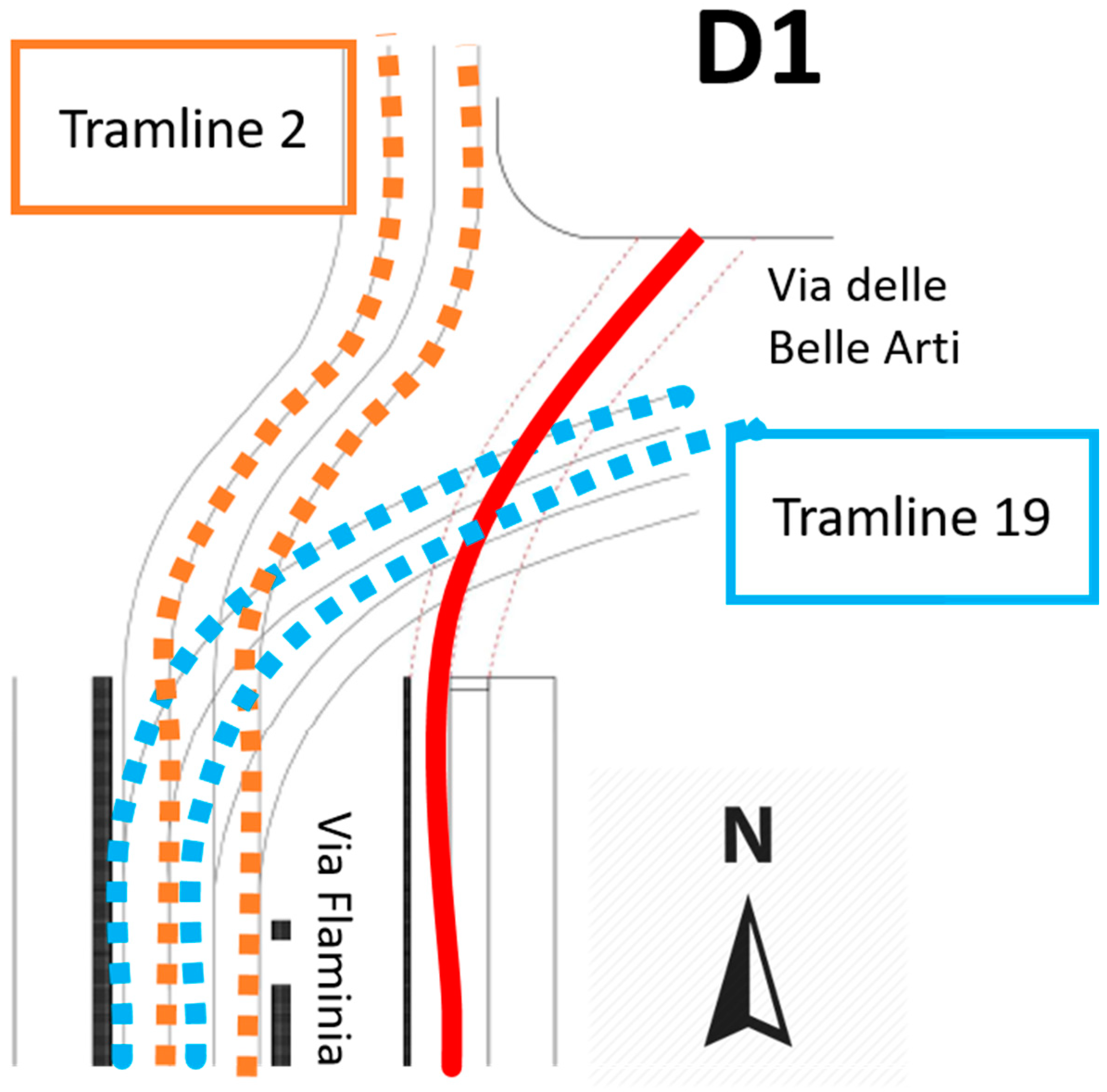
  • Via delle Belle Arti/Via Flaminia (Figure 12D) is a complex junction managed by an intelligent traffic control installed at a four-phase signal. Two tramlines run in the area: they move on Via Flaminia or move on Via Flaminia (dotted orange line in Figure 12D) and Via delle Belle Arti (dotted blue line in Figure 12D). Cyclists should ride on Via delle Belle Arti.
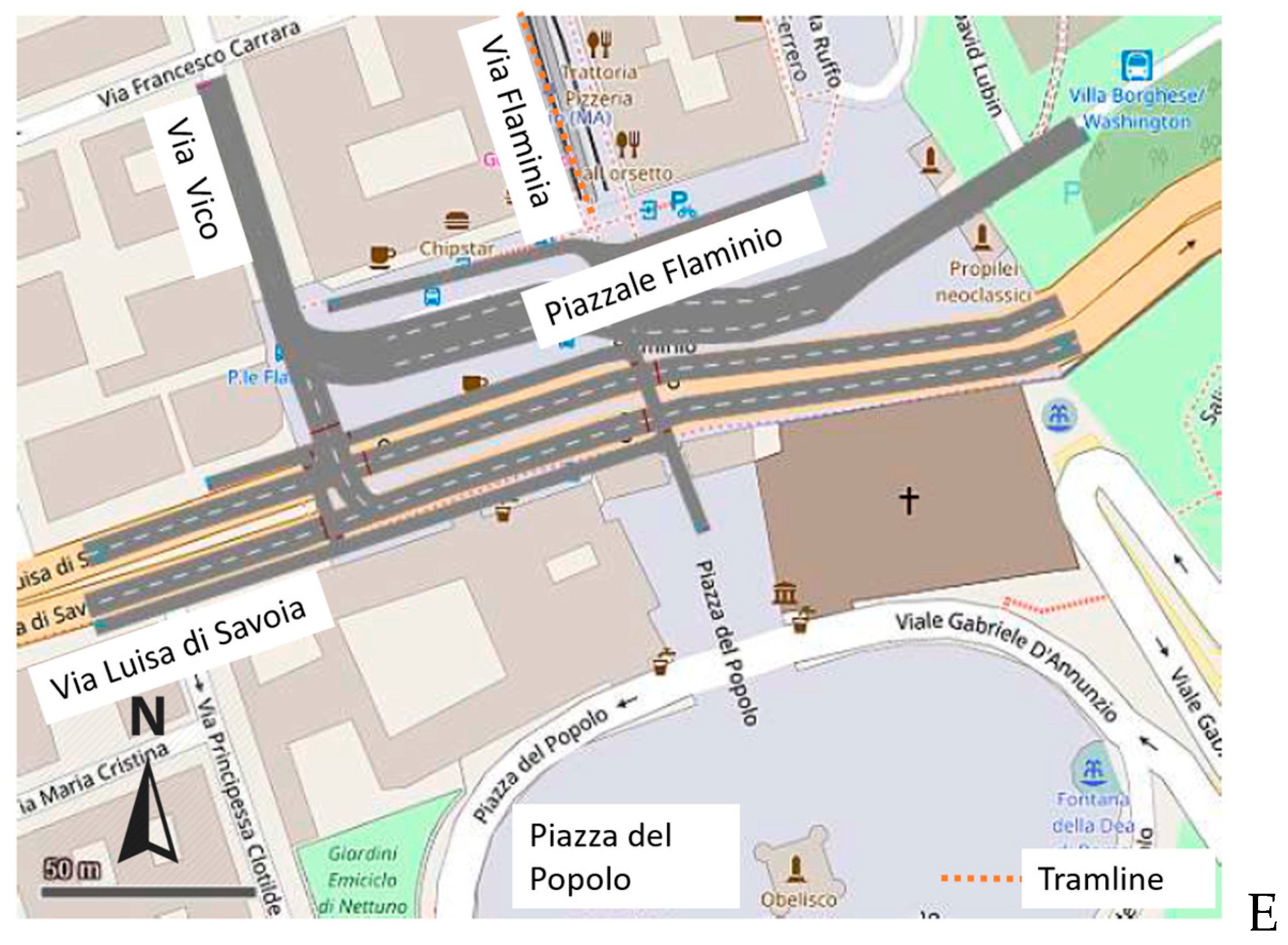
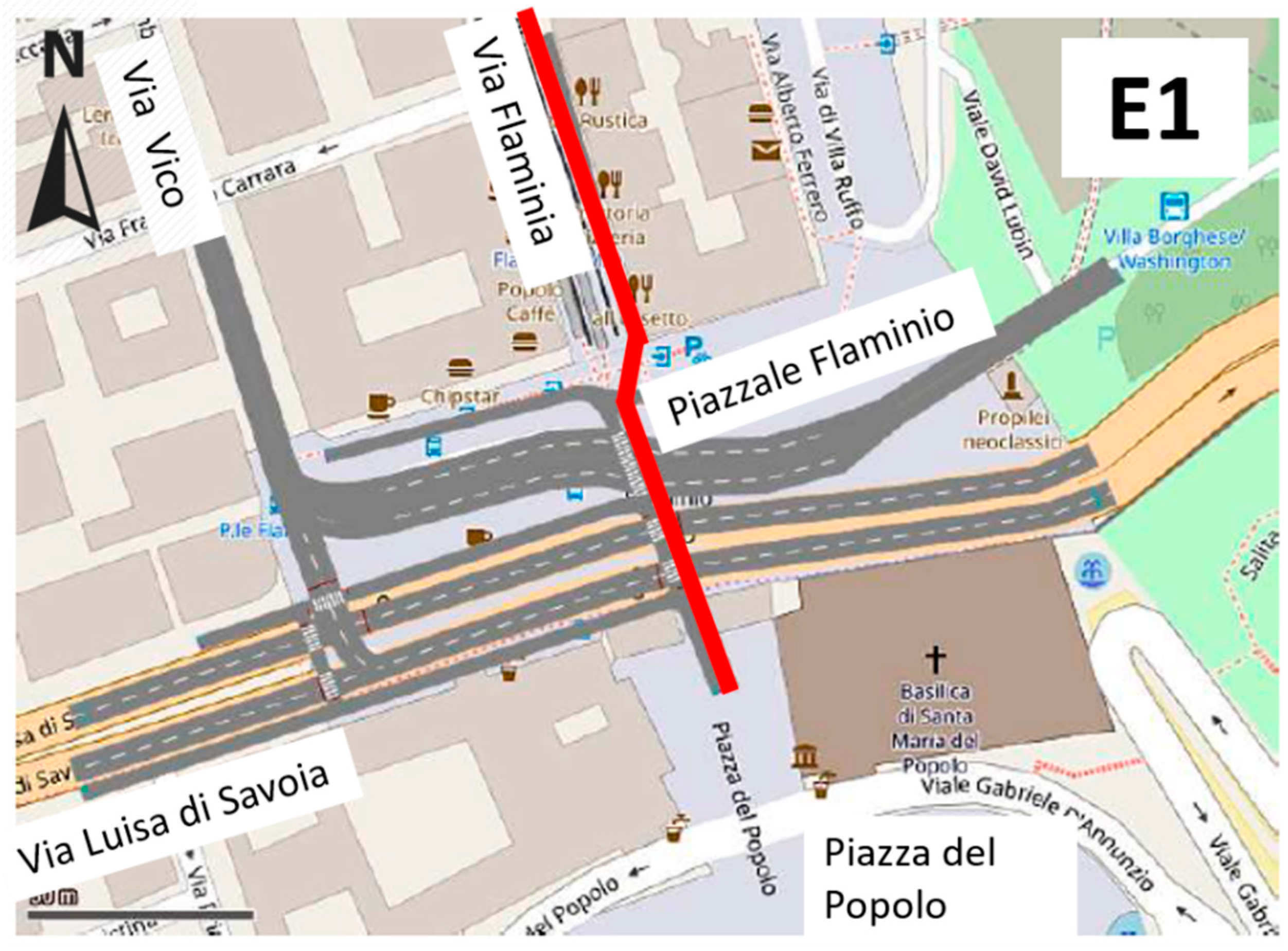
  • Piazzale Flaminio is the ending point of the new cycle path. It is a junction where important pedestrian and motorized flows interact. It is a crucial node in the center of Rome, where bus, railway and metro stops are (Figure 12E).
VISSIM provided the traffic analysis of the listed five junctions: it consisted of at least six simulations for each phase of allowable movements. Each simulation was 100 s long and considered the surveyed traffic volume at the intersection. For each simulation run, the maximum queue length value (QLENMAX) and the total number of passed vehicles (VEHS) have been considered. These values allowed the comparison between the existing and proposed configurations in order to identify the best performing proposal.
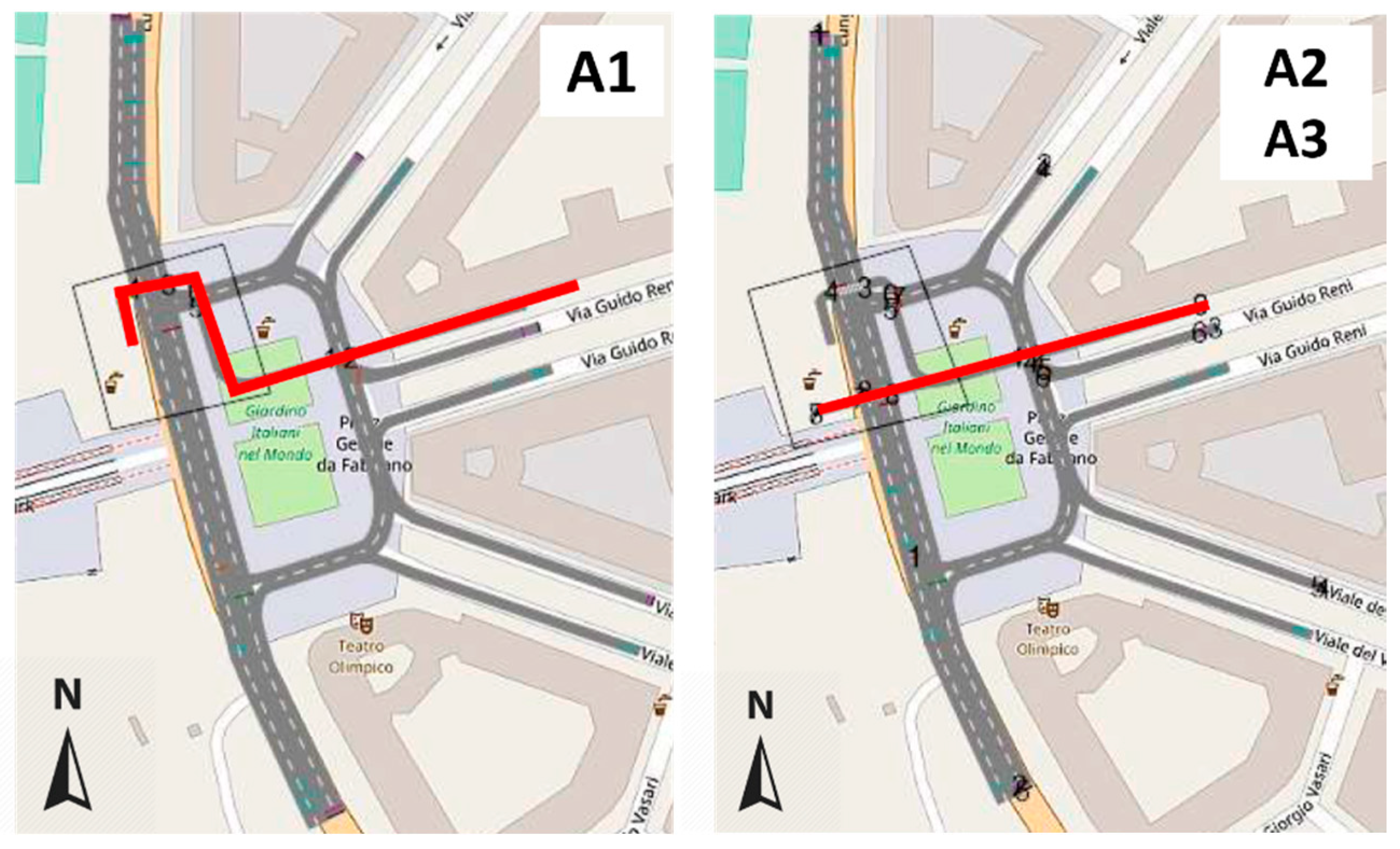
A. Piazza Gentile da Fabriano:
Three different alternatives have been considered (Figure 13); A0 is the existing condition (Figure 12A). In Figure 13 and the next few figures, the new cycle path is represented with a red line.
A1: Coming from the external right lane of Via Guido Reni, the cycle path will move through Piazza Gentile da Fabriano and cross Lungotevere Flaminio using the existing zebra crossing on the upper part of the junction, reaching the sidewalk of Lungotevere Flaminio.
A2: Coming from the external right lane of Via Guido Reni, the cycle path will move through Piazza Gentile da Fabriano using the existing zebra crossing; then, it crosses Lungotevere Flaminio using a new zebra crossing reserved for bikes. In this scenario, the northern traffic light is moved 30 m back in order to guarantee a safe crossing for bicycles.
A3: This scenario differs from the last one in the protection strategies: the cyclists are protected both from northbound and westbound cars using repeater lights.
For the sake of brevity, Table 3 lists the movements, which cause the extreme values of the queue length (QLENMAX), and the total number of passed vehicles at the intersection calculated for each alternative. QLENMAX,u and QLENMAX,l are respectively the maximum and the minimum value of QLENMAX.
Functional performances of A3 are comparable to those of A0 (i.e., QLENMAX,u is 46 and 47 m, respectively, and VEHS are 29 and 28, respectively). Moreover, A3 offers the best results in terms of cyclists’ safety and implementation costs because it provides a direct route for cyclists, which are encouraged to move on their marked infrastructure, and it only requires the installation of repeater lights to ensure an adequate level of overall safety and to minimize the risk of collisions with motorized vehicles. Indeed, A1 has a bicycle path parallel to the pedestrian one, and it requires the construction of two more traffic lights, in order to ensure the continuity of the cycle path; A2, as A1, does not provide direct bicycle routes: this can lead to crossing Lungotevere Flaminio without zebra crossings, resulting in fatal accidents.
According to these results, A3 has been chosen as the functional solution for Piazza Gentile da Fabriano.
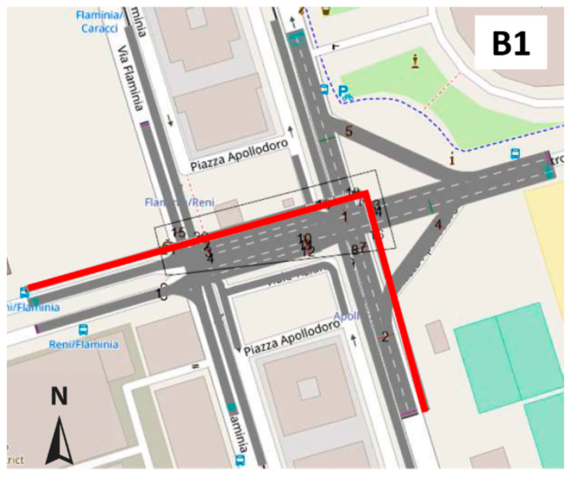
B. Piazza Apollodoro:
The intersection in Piazza Apollodoro is composed of two junctions, and both are managed by two-phase traffic lights: the former is for Via Guido Reni and Via Flaminia, the latter is for Via de Coubertin and Viale Tiziano (Figure 14):
  • Via Flaminia crossing Via Guido Reni:
    Phase I: cars coming from Via Guido Reni can move to Piazza Apollodoro or turn on Via Flaminia. Cars approaching Piazza Apollodoro can continue along Via Guido Reni or turn on Via Flaminia;
    Phase II: cars move along Via Flaminia.
  • Viale Tiziano crossing Via De Coubertin:
    Phase I: cars moving along Via De Coubertin can only go straight. Cars coming from Piazza Apollodoro can continue along Via De Coubertin or turn on Viale Tiziano;
    Phase II: cars move along Viale Tiziano.
An intelligent traffic control currently manages the tram circulation along Viale Tiziano (B0): once the tram closes the doors at the stop before Piazza Apollodoro, the traffic light for the tram automatically turns green in Piazza Apollodoro, giving the red signal to other vehicle flows. In VISSIM, the dynamic traffic signal control cannot be modelled: a linear process was introduced in order to overcome this problem. The authors assumed that the tram passed once every 10 min. Each analysis lasted 600 s, and it was composed of five runs (i.e., all 500 s) conducted without trams (i.e., green traffic lights for cars and red traffic lights for Tram Scenario B0) and one run (i.e., 100 s) reserved for tram flow introducing a new traffic light (i.e., red traffic lights for cars and green traffic lights for Tram Scenario B1).
In the future layout (B1), the bicycle path will run along Via Guido Reni, parallel to the left sidewalk until reaching the first junction, and then, it will move on the right car lane. Then, cyclists will run parallel to the existing zebra crossing at Viale Tiziano junction (a dedicated zebra crossing for cyclists will be realized), and they will decide to move either to the Auditorium corridor (left turn) or to the new one (right turn), which will be parallel to Viale Tiziano.
The extreme results of the VISSIM analyses are listed in Table 4, where the existing (B0, Figure 12B) and the future (B1) layouts are compared. For B1, QLENMAX,l coincided with QLENMAX,u because only one 100 s-long run had been performed.
In order to reserve a traffic light phase for the tram, B1 has the traffic light cycle increased compared to B0. However, this solution does not increase the level of congestion: the values of QLENMAX,u of B0 and B1 were comparable (i.e., 45 and 49 m, respectively); therefore, B1 was adopted as the future configuration.
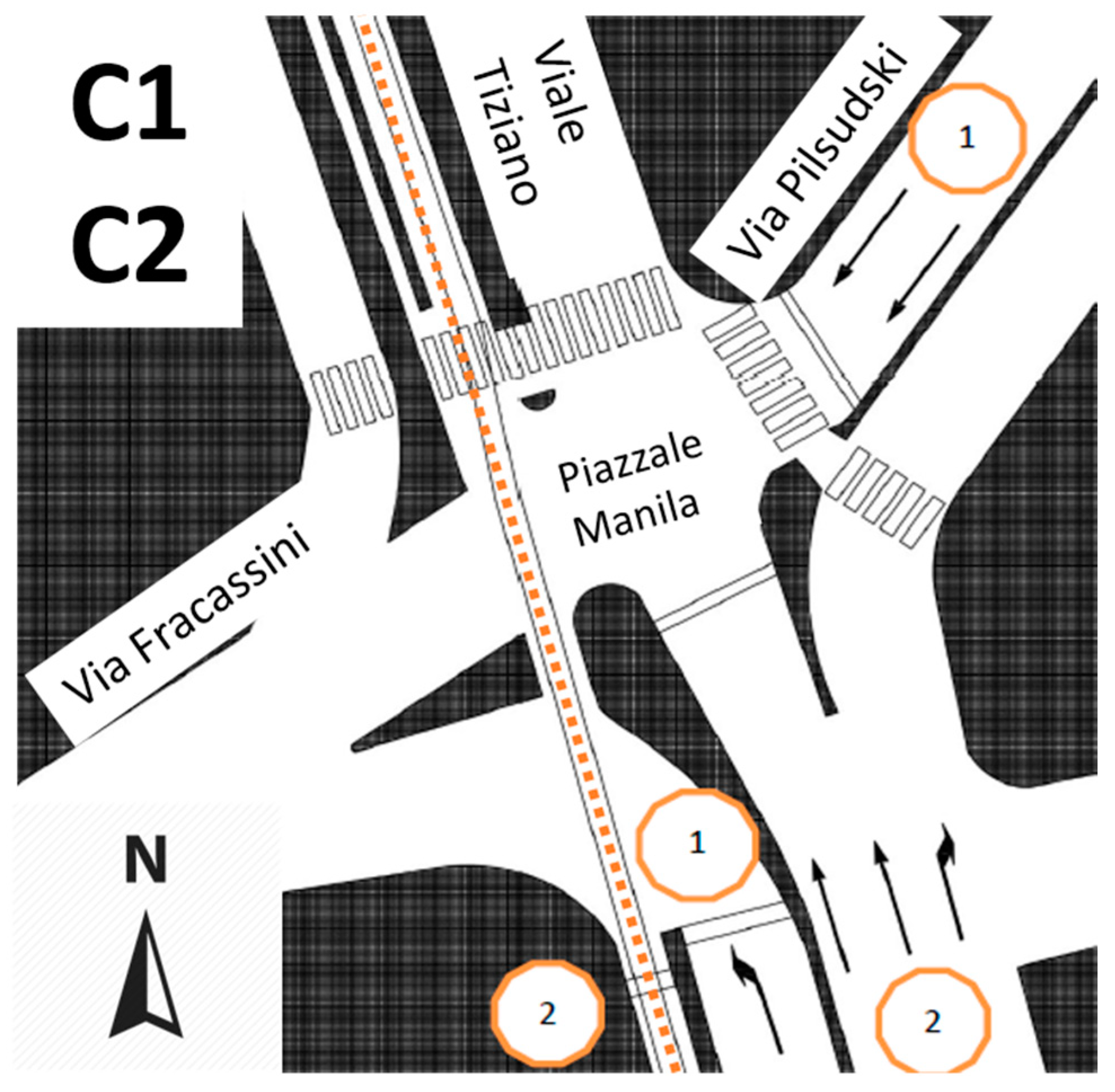
C. Piazzale Manila:
The node in Piazzale Manila is a very complex intersection, as represented in Figure 15. Traffic is currently managed by a two-phase traffic light (Numbers 1–3); unlike Piazza Apollodoro, no intelligent traffic light system is adopted:
  • Phase I: cars coming from Viale Tiziano can move to Via Fracassini. Cars coming from Viale Pildzusky can approach Piazzale Manila, continue along Via Fracassini or turn right on Viale Tiziano;
  • Phase II: cars and trams move along Viale Tiziano.
The most congested part of the junction is Viale Tiziano (north-south direction), where only one arm serves three vehicular currents.
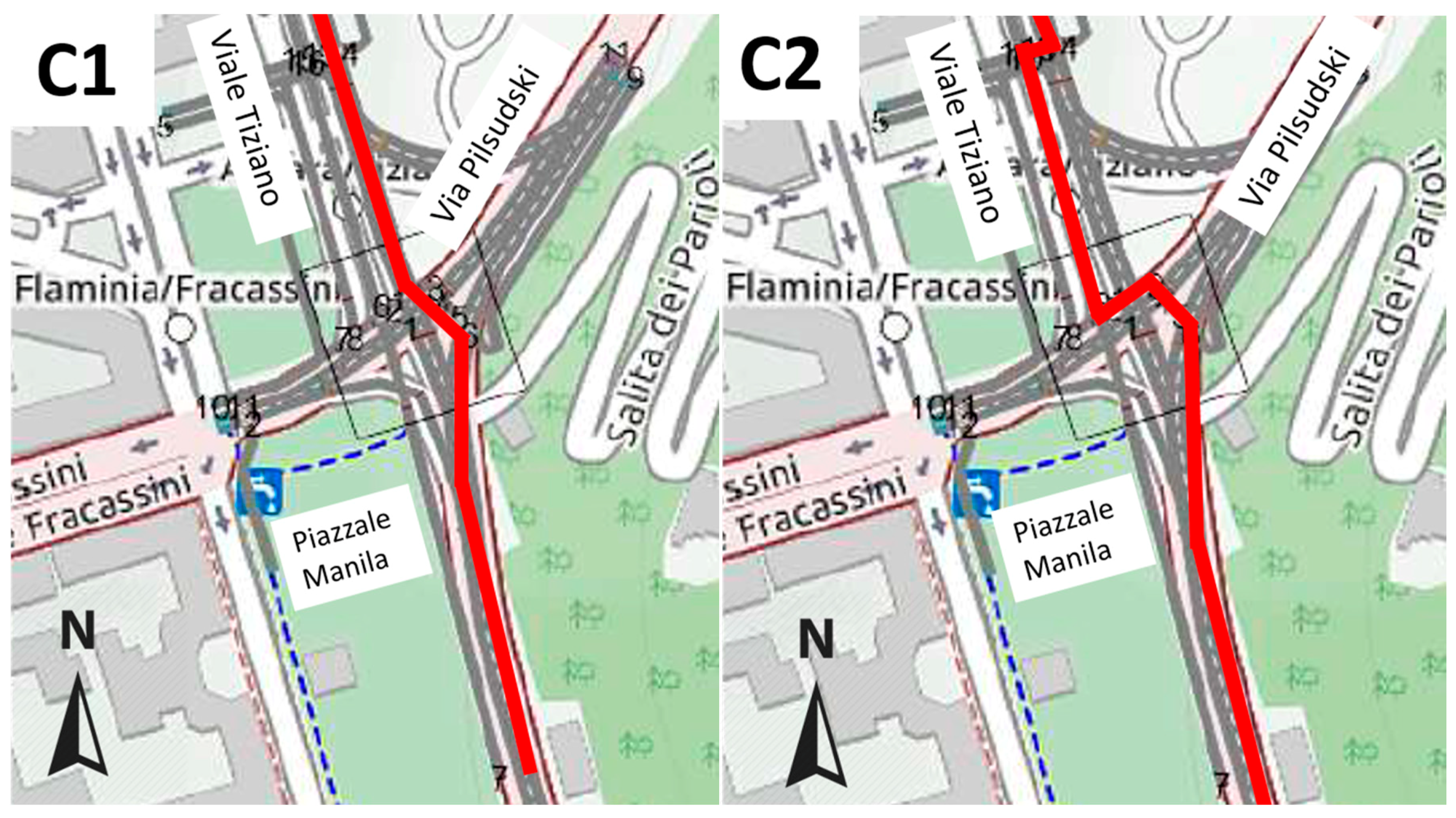
Two alternatives (i.e., C1 and C2, Figure 16) have been considered to allow cyclists to cross the intersection; C0 is the existing configuration (Figure 12C):
C1: Moving on the left side of Viale Tiziano, cyclists cross Viale Pilsudski and reach Salita dei Parioli. This solution requires the installation of a new traffic light for bike crossing and the elimination of parking lots.
C2: A new traffic light is implemented: It allows cyclists to move on the right lane parallel to Viale Tiziano, which will be reserved for bikes. Then, they cross Piazzale Manila to reach Salita dei Parioli.
The worst results of the VISSIM analyses are listed in Table 5.
As regards the geometrical and functional issues, C1 is the simplest solution, but it forces removing many parking lots and causes an unacceptable level of congestion: along Viale Tiziano, queue length computation gave very high values during each 100 s-long simulation. Compared to C1, C2 gave lower values for QLENMAX,u (i.e., 192 vs. 204 m), with a distribution between the upper and lower values of QLENMAX similar to C0 (i.e., QLENMAX,u was about six-times more than QLENMAX,l). Furthermore, C2 ensures values of VEHS higher than those of C0 (i.e., 97 vs. 86 when considering QLENMAX,u, and 50 vs. 43 when considering QLENMAX,l). Therefore, C2 has been adopted as the final configuration.
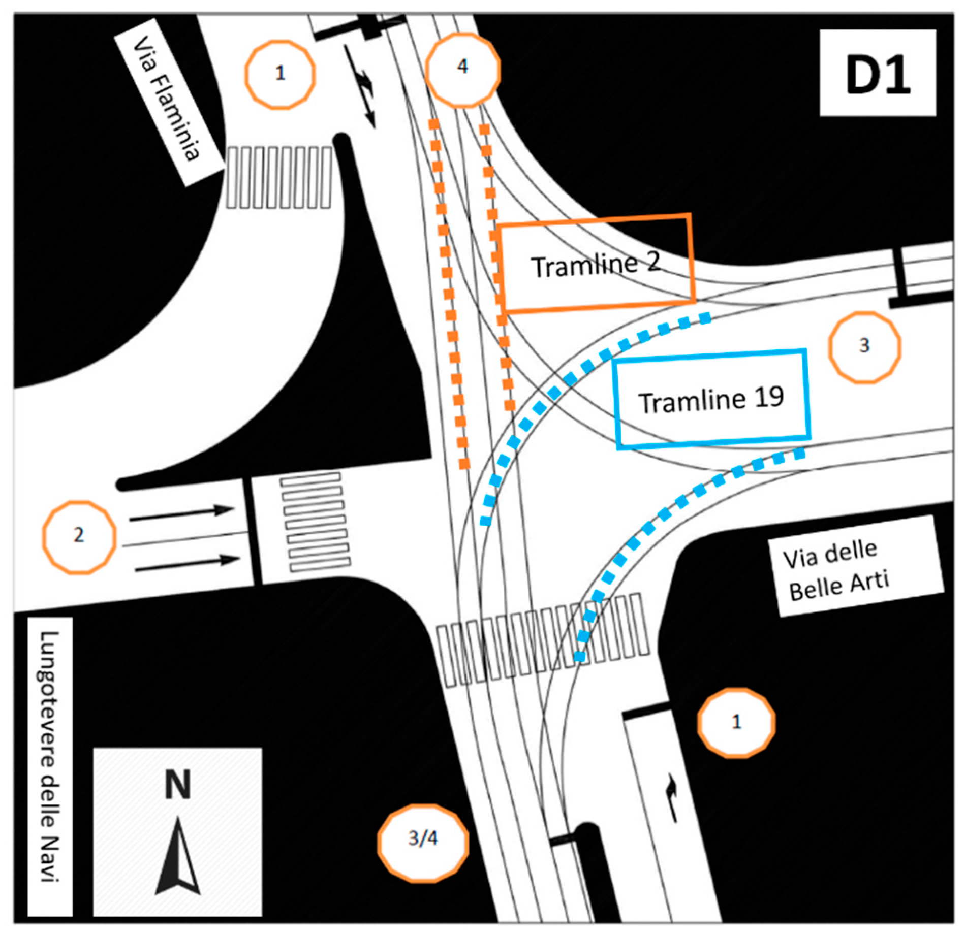
D. Via delle Belle Arti/Via Flaminia:
The intersection Via delle Belle Arti/Via Flaminia is a T-shaped intersection of vehicle and tram paths (dotted lines in Figure 17) managed by a four-phase variable signal:
  • Phase I: vehicles move along Via Flaminia or come from Via Flaminia and turn right on Via delle Belle Arti;
  • Phase II: vehicles coming from Lungotevere delle Navi go to Via delle Belle Arti;
  • Phase III: Tramline 19 moves;
  • Phase IV: Tramline 2 moves.
The arrival of trams is stochastic; therefore, an intelligent traffic control is installed. Three cycles with different cycle times and phases can be detected:
  • no tram arrives at the junction (101 s-long cycle);
  • one tram (i.e., Tramline 19 or 2) is approaching the junction (128 s-long cycle);
  • two trams (Tramlines 19 and 2) approach the junction (128 s-long cycle).
As for the Piazza Apollodoro intersection, VISSIM cannot simulate this kind of junction. The authors modelled the most critical cycle: the third one. In order to allow bicycles to cross the section, traffic light phases have been modified as follows:
  • Phase I: vehicles move along Via Flaminia or come from Via Flaminia and turn on Via delle Belle Arti;
  • Phase II: vehicles coming from Lungotevere delle Navi go to Via delle Belle Arti;
  • Phase III: cyclists cross the intersection (Figure 18);
  • Phase IV: Tramline 19 moves;
  • Phase V: Tramline 2 moves.
The rail crossing has been designed balancing the often-conflicting objectives of safety and convenience:
  • it is set with a more than 45° angle of intersection according to the AASHTO Guide Book [19] to ensure the significant issue of safe geometric design;
  • it does not prolong the cycle path, in order to avoid cyclists leaving the reserved lanes and using unreserved spaces (e.g., sidewalks or carriageway,) causing new and hazardous conflict points.
Table 6 compares the results of the existing (D0, Figure 12D) and future intersection (D1).
D1 requires the installation of a five-phase signal instead of the existing four-phase one. Therefore, it increases the congestion along the itinerary and reduces the values of VEHS (68 in D1 instead of 85 in D0 when considering QLENMAX,u), as listed in Table 6, but it can solve a junction where three different transport modes occur (i.e., tram, bicycle and motorized vehicles). However the increase of QLENMAX,u was 5.75% with respect to the value calculated for D0 (i.e., 197 m); similar results have been obtained for QLENMAX,l (i.e., 135 m for D0 and 131 m for D1): D1 can be implemented.
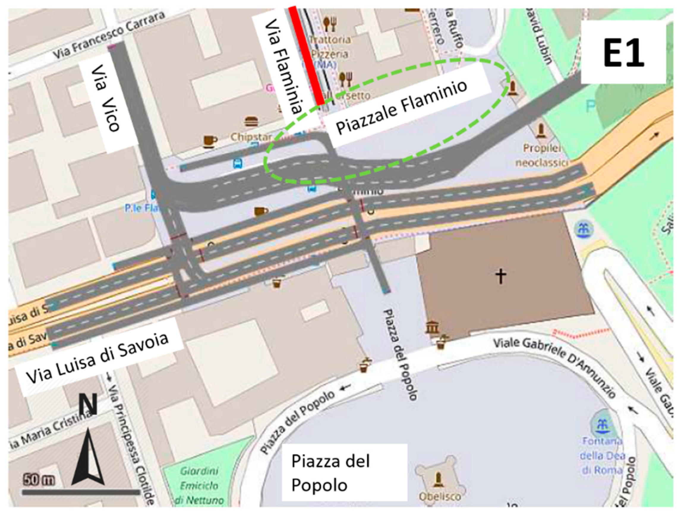
E.  Piazzale Flaminio:
Piazzale Flaminio is the last intersection analyzed with VISSIM. Cyclists from Via Flaminia arrive at a large pedestrian area in Piazzale Flaminio (dotted green circle in Figure 19).
Since this area is particularly congested by pedestrians, a direct passage for bicycles should be provided to reduce conflict points between users, to avoid interfering with the tram terminus at the beginning of Via Flaminia and to allow cyclists to arrive at Piazza del Popolo.
At present, two traffic lights manage the motorized traffic:
  • Phase 1: private vehicles run along Via Luisa di Savoia, and buses run on the protected lane;
  • Phase 2: private vehicles from Via Vico can only turn on Via Luisa di Savoia.
A direct passage for bicycles has been defined to arrive at Piazzale Flaminio, the end point of the new path (Figure 20). The passage of cyclist flow is separated from the pedestrian one. The volume of bike traffic was set at 100 veh/h: the flow of users from Via Flaminia was less than 100 veh/h, but an increase is expected shortly.
Table 7 compares the results of the existing (E0, Figure 12E) and future intersection (E1).
The results demonstrate that E0 is an intersection that is a bit congested: its QLENMAX,u was 99 m; the results of E1 in terms of QLENMAX,u were very similar to those obtained for E0: QLENMAX,u was 95 m. As regards VEHS, the value of passed vehicles in E1 was about 10% less than in E0. However, E1 could be accepted as a functional solution because it provided the shortest and most direct route to reach the final destination of the new cycle path: Piazza del Popolo is in the historical center of Rome, where wide spaces are reserved for pedestrians and cyclists.

4. Discussion

The implementation of a new cycle path in an existing road network conceived and built for motorized vehicles requires the adoption of innovative and versatile geometrical and functional criteria. In particular, the examined case study involves a historical district in the Municipality of Rome, where the urban framework constrains urban traffic development. However, the building of a continuous network of bike routes is strategic to provide access to sustainable transport systems, improving road safety with special attention to the needs of vulnerable users.
The proposed methodological approach is composed of a two-part process. The first one is related to the geometrical design of the bike lanes. For this purpose, the Italian standard of the technical characteristics of bicycle paths has been adopted to define the geometry of the new infrastructure, except at the intersections, where Danish, Spanish and American standards were considered. In fact, the Italian standard does not provide any description, neither on road signs nor urban furniture at intersections. Because of these lacking descriptions, all the solutions needed a micro-simulation of traffic flows, in order to ensure both user safety and traffic level of service. This matter is the second part of the proposed methodological approach, and it was performed by using the commercial software package PTV VISSIM 8. In this phase, a linear process has been modelled to describe dynamic intelligent traffic controls, which currently manage the tram flow at intersections. This approach is innovative because it solves scenarios not included in the software.
Therefore, the holistic methodology can be applied in a large number of different urban scenarios. Indeed, the traffic problem solving approach can be applied to different cases, when bike infrastructures should be implemented in busy urban contexts. The methodology is paramount due to the growing attention on sustainable transport systems needs for a comprehensive, simple and versatile methodology to be applied.

5. Conclusions

Cycling mobility is growing in congested urban areas, where this type of user is the most vulnerable. Installation of traffic lights and the design of reserved lanes or paths for cyclists are provided to avoid the high risk of accidents resulting from user heterogeneity.
This paper presents the design and traffic analysis of a new cycle path to be constructed in the northeast part of Rome’s municipality. The path will be part of the existing functional bicycle network, and it will be in a congested area where several dangerous intersections are. Trams, buses, private vehicles and pedestrians will interact with cyclists: for this reason, the design pursued the objectives of not worsening the flow of motorized vehicles, reducing conflict points and maintaining the two-wheel infrastructure continuity.
The design methods regarding the geometry of cross-sections comply with the Italian standards in force regarding bike paths: eight different cross-sections have been defined to fit the boundary conditions. The geometric design of the new infrastructure aimed to not prolong the cycle path, in order to avoid cyclists leaving the reserved lanes and using unreserved spaces. For this purpose, the designed rail crossing did not have a 90° (but more than 45°) angle of intersection to encourage the correct use of the infrastructure.
The traffic analysis of the new infrastructure has been carried out using the software package PTV VISSIM 8: the results allowed the comparison of the starting and future layouts considering the existing volume of vehicle traffic and hypothesizing a future bike volume of 100 cyclists/h. For each examined intersection, six simulation runs have been performed, and the maximum queue length (QLENMAX) and the total number of passed vehicles of the most critical maneuvers have been considered. A linear process has been modelled to describe dynamic intelligent traffic controls that currently manage the tram flow: the most critical cycle has been analyzed.
The results from the study offer a traffic problem solving approach that can be used for similar cases (type of city, traffic conditions, several transport modes, intersection layouts, built urban environment). The study underlines the needs for a serious design process in order to design new bicycle paths correctly in existing urban areas. Indeed, geometrical and functional issues should be analyzed with a specific microscopic traffic simulator to develop before-after models for each intersection.

Author Contributions

P.D.M. and G.F. conceived of and designed the work. G.G. performed the study. L.M. and A.R. analyzed the data. All the authors wrote the paper.

Funding

This research received no external funding.

Acknowledgments

The map data are copyrighted by OpenStreetMap contributors and available at https://www.openstreetmap.org. The contents retrieved from OpenStreetMap are under the Creative Commons Attribution-ShareAlike 2.0 license www.openstreetmap.org/copyright.

Conflicts of Interest

The authors declare no conflict of interest.

References

  1. ITF. Road Safety Annual Report 2017; OECD Publishing: Paris, France, 2017.
  2. Kirolos, H.; Alluri, P.; Gan, A. Analyzing pedestrian crash injury severity at signalized and non-signalized locations. Accid. Anal. Prev. 2015, 81, 14–23. [Google Scholar]
  3. Canale, S.; Leonardi, S.; Pappalardo, G. The Reliability of the Urban road Network: Accident Forecast Models. In Proceedings of the III International Congress SIIV-People, Land, Environment and Transport Infrastructures, Bari, Italy, 22–24 September 2005. [Google Scholar]
  4. Corazza, M.V.; Musso, A.; Finikopoulos, K.; Sgarra, V. An analysis on health care costs due to accidents involving powered two wheelers to increase road safety. Accid. Anal. Prev. 2016, 14, 323–332. [Google Scholar] [CrossRef]
  5. Piantini, S.; Baldanzini, N.; Pierini, M.; Mangini, M.; Franci, A.; Peris, A. An Overview on Pedestrians and Cyclists Serious Injuries in Urban Accidents. In Proceedings of the International Research Council on Biomechanics of Injury (IRCOBI), Zurich, Switzerland, 9–11 September 2015. [Google Scholar]
  6. Ragnoli, A.; Corazza, M.V.; Di Mascio, P.; Musso, A. Maintenance priority associated to powered two-wheeler safety. WIT Trans. Built Environ. 2018, 176, 453–464. [Google Scholar]
  7. Sgarra, V.; Di Mascio, P.; Corazza, M.V.; Musso, A. An application of ITS devices for powered two-wheelers safety analysis: the Rome case study. Adv. Transp. Stud. 2014, 33, 85–96. [Google Scholar]
  8. Karanikola, P.; Panagopoulos, T.; Tampakis, S.; Tsantopoulos, G. Cycling as a smart and green mode of transport in small touristic cities. Sustainability 2018, 10, 268. [Google Scholar] [CrossRef]
  9. Day, K.; Alfonzo, M.; Chen, Y.; Guo, Z.; Lee, K.K. Overweight, Obesity, and inactivity and urban design in rapidly growing Chinese cities. Health Place 2013, 21, 29–38. [Google Scholar] [CrossRef] [PubMed]
  10. Musso, A.; Corazza, M.V. Improving urban mobility management: Case study of Rome. Transp. Res. Rec.: J. Transp. Res. Board 2006, 1956, 52–59. [Google Scholar] [CrossRef]
  11. Zhang, Y.; Yang, X.; Li, Y.; Liu, Q.; Li, C. Household, personal and environmental correlates of rural elderly’s cycling activity: Evidence from Zhongshan metropolitan area, China. Sustainability 2014, 6, 3599–3614. [Google Scholar] [CrossRef]
  12. Madsen, T.K.O.; Lahrmann, H. Comparison of five bicycle facility designs in signalized intersections using traffic conflict studies. Transp. Res. Part F: Traffic Psychol. Behav. Part B 2017, 46, 438–450. [Google Scholar] [CrossRef]
  13. Zhang, T.; Chan, A.H.S. Traffic Sign Comprehension: A Review of Influential Factors and Future Directions for Research. In Proceedings of the International MultiConference of Engineers and Computer Scientists 2013 Vol II, IMECS 2013, Hong Kong, China, 13–15 March 2013. [Google Scholar]
  14. Loprencipe, G.; Pantuso, A.; Di Mascio, P. Sustainable pavement management system in urban areas considering the vehicle operating costs. Sustainability 2017, 9, 453. [Google Scholar] [CrossRef]
  15. Robusté, F. The Future of Transport in Urban Areas. Available online: http://www.europarl.europa.eu/RegData/etudes/note/join/2009/431580/IPOL-TRAN_NT(2009)431580_EN.pdf (accessed on 17 August 2018).
  16. Goldsmith, S.A. Reasons Why Bicycling and Walking Are and Are not Being Used More Extensively as Travel Modes; Federal Highway Administration: Washington, DC, USA, 1993.
  17. Okraszewska, R.; Birr, K.; Gumińska, L.; Michalski, L. Growing Role of Walking and Cycling and the Associated Risks. Available online: https://www.matec-conferences.org/articles/matecconf/abs/2017/36/matecconf_gambit2017_01006/matecconf_gambit2017_01006.html (accessed on 17 August 2018).
  18. Iwińska, K.; Blicharska, M.; Pierotti, L.; Tainio, M.; de Nazelle, A. Cycling in Warsaw, Poland-perceived enablers and barriers according to cyclists and non-cyclists. Transp. Res. Part A: Policy Pract. 2018, 113, 291–301. [Google Scholar] [CrossRef] [PubMed]
  19. AASHTO. Guide for the Development of Bicycle Facilities, 4th ed.; American Association of State Highway and Transportation Officials: Washington, DC, USA, 2012. [Google Scholar]
  20. Sanz, A.; Pérez Senderos, R.; Fernández, T. La bicicleta en la ciudad. Manual de políticas y diseño para fomentar el uso de la bicicleta como m vedio de transporte; Ministero de Fomiento: Madrid, Spain, 1999.
  21. European Commission. The Future Development of the Common Transport Policy: A Global Approach to the Construction of a Community Framework for Sustainable Mobility—White Paper; COM (92) 494 final; European Commission: Brussels, Belgium, 1992.
  22. Miccoli, S.; Finucci, F.; Murro, R. A New Generation of Urban Areas: Feasibility Elements. Advances in Energy Science and Equipment Engineering. In Proceedings of the International Conference on Energy Equipment Science and Engineering, Guangzhou, China, 30–31 May 2015; pp. 1445–1450. [Google Scholar]
  23. Miccoli, S.; Finucci, F.; Murro, R. Urban green infrastructures and social shared choices: A deliberative valuation method. Appl. Mech. Mater. 2014, 641–642, 1082–1086. [Google Scholar] [CrossRef]
  24. The Danish Road Directorate. Collection of Cycle Concepts; Cycling Embassy of Denmark: Copenhagen, Denmark, 2000.
  25. Cantisani, G.; Loprencipe, G.; Primieri, F. The Integrated Design of Urban Road Intersections: A Case Study. In Proceedings of the ICSDC—The International Conference on Sustainable Design and Construction, Kansas City, MO, USA, 23–25 March 2012. [Google Scholar]
  26. Cantisani, G.; Moretti, L.; De Andrade Barbosa, Y. Safety problems in urban cycling mobility: quantitative risk analysis at urban intersections. Saf. Sci. 2018, Accepted. [Google Scholar]
  27. Isaksson-Hellman, I.; Werneke, J. Detailed description of bicycle and passenger car collisions based on insurance claims. Saf. Sci. 2017, 92, 330–337. [Google Scholar] [CrossRef]
  28. Feliziani, V.; Miarelli, M. How Many visitors should there be in the city? the case of Rome. Rev. Eur. Stud. 2012, 4, 179–187. [Google Scholar] [CrossRef]
  29. Shearer, D. Shared Spaces in New Zealand Urban Areas. Master’s Thesis, University of Otago, Dunedin, Otago, New Zealand, 2011. [Google Scholar]
  30. Di Mascio, P.; Corazza, M.V. Two Pilot Projects in the Italian Plan for Road Safety to Increase Pedestrian Safety. In Proceedings of the 22nd PIARC World Road Congress, Durban, South Africa, 19–25 October 2003. [Google Scholar]
  31. Elvik, R.; Erke, A.; Christensen, P. Elementary units of exposure. Transp. Res. Rec.: J. Transp. Res. Board 2009, 2103, 25–31. [Google Scholar] [CrossRef]
  32. VISSIM 2015. Version 8 User Manual. PTV Planug Transport Verkehr AG, Innovative Transportation Concepts, Inc.: Karlsruhe, Germany, 2015.
  33. Saidallah, M.; El Fergougui, A.; Elbelrhiti Elalaoui, A. A Comparative Study of Urban Road Traffic Simulators. Available online: https://www.matec-conferences.org/articles/matecconf/abs/2016/44/matecconf_ictte2016_05002/matecconf_ictte2016_05002.html (accessed on 19 August).
  34. Transportation Research Board. Highway Capacity Manual 6th Edition: A Guide for Multimodal Mobility Analysis; The National Academies Press: Washington, DC, USA, 2016. [Google Scholar]
  35. Yu, L.; Chen, X.M.; Wan, T.; Guo, J.F. Calibration of VISSIM for bus rapid transit systems in Beijing 23 Using GPS Data. J. Public Transp. 2006, 9, 239–257. [Google Scholar] [CrossRef]
  36. Asamer, J.; Zuylen, H.J.; Heilmann, B. Calibrating VISSIM to Adverse Weather Conditions. In Proceedings of the 2nd International Conference on Models and Technologies for Intelligent Transportation Systems 2011, Leuven, Belgium, 22–24 June 2011. [Google Scholar]
  37. Park, B.; Schneeberger, J.D. Microscopic Simulation Model Calibration and Validation: A Case Study of VISSIM for a Coordinated Actuated Signal System. In Proceedings of the Transportation Research Board Annual Meeting 2002, Washington, DC, USA, 13–17 January 2002. [Google Scholar]
  38. Italian Ministry of public works. Regolamento per la definizione delle caratteristiche tecniche delle piste ciclabili; Decreto Ministero dei Lavori Pubblici: Rome, Italy, 1999.
  39. Combes, F.; van Nes, R. A simple representation of a complex urban transport system based on the analysis of transport demand: The case of Region Ile-de-France. Procedia—Soc. Behav. Sci. 2012, 48, 3030–3039. [Google Scholar] [CrossRef]
  40. Van Nes, R. Design of Multimodal Transport Networks, a Hierarchical Approach. Ph.D. Thesis, Technische Universiteit Delft, Delft, The Netherlands, 2002. [Google Scholar]
  41. Masip-Tresserra, J. Policentriity, Performance and Planning: Concepts, Evidence and Policy in Barcelona, Catalonia; Architecture and the Built Environment: Delft, The Netherlands, 2016; ISBN 978-94-6186-631-8. [Google Scholar]
  42. Ramos, R.; Cantillo, V.; Arellana, J.; Sarmiento, I. From restricting the use of cars by license plate numbers to congestion charging: Analysis for Medellin, Colombia. Transp. Policy 2017, 60, 119–130. [Google Scholar] [CrossRef]
  43. Aguilera, A.; Grébert, J. Passengers transport modes hierarchy and trends in cities: results of a worldwide survey. In Proceedings of the Transport Research Arena (TRA) 5th Conference: Transport Solutions from Research to Deployment, Paris, France, 14–17 April 2014. [Google Scholar]
  44. Saliara, K. Public Transport Integration: The Case Study of Thessaloniki, Greece. Transp. Res. Procedia 2014, 4, 535–552. [Google Scholar] [CrossRef]
  45. Cheng, H. Hierarchical Urban Transit System Design for Reducing Greenhouse Gas Emissions and Societal Costs. Dissertation submitted in partial satisfaction of the requirements for the degree of Doctor of Philosophy in Engineering—Civil and Environmental Engineering in the Graduate Division of the University of California, Berkeley. Available online: http://digitalassets.lib.berkeley.edu/etd/ucb/text/Cheng_berkeley_0028E_16190.pdf (accessed on 10 August 2018).
  46. Deng, T.; Nelson, J.D. Recent developments in bus rapid transit: a review of the literature. Transp. Rev. 2011, 31, 69–96. [Google Scholar] [CrossRef]
Figure 1. Existing layout of the functional transport network.
Sustainability 10 02951 g001
Figure 2. Designed cycle path (retrieved from Google Earth).
Sustainability 10 02951 g002
Figure 3. Cross-section No. 1.
Sustainability 10 02951 g003
Figure 4. Cross-section No. 2.
Sustainability 10 02951 g004
Figure 5. Cross-section No. 3.
Sustainability 10 02951 g005
Figure 6. Cross-section No. 4.
Sustainability 10 02951 g006
Figure 7. Cross-section No. 5.
Sustainability 10 02951 g007
Figure 8. Cross-section No. 6.
Sustainability 10 02951 g008
Figure 9. Cross-section No. 7.
Sustainability 10 02951 g009
Figure 10. Cross-section No. 8.
Sustainability 10 02951 g010
Figure 11. Vertical signs.
Sustainability 10 02951 g011
Figure 12. The existing most critical intersections (map data © OpenStreetMap contributors).
Sustainability 10 02951 g012aSustainability 10 02951 g012b
Figure 13. Junction scenarios for Piazza Gentile da Fabriano (map data © OpenStreetMap contributors).
Sustainability 10 02951 g013
Figure 14. Layout of Piazza Apollodoro (B1) (map data © OpenStreetMap contributors).
Sustainability 10 02951 g014
Figure 15. Layout of the Piazzale Manila intersection.
Sustainability 10 02951 g015
Figure 16. Junction scenarios for Piazzale Manila (map data © OpenStreetMap contributors).
Sustainability 10 02951 g016
Figure 17. Layout of the Via delle Belle Arti/Via Flaminia intersection.
Sustainability 10 02951 g017
Figure 18. Rail crossing at the Via delle Belle Arti/Via Flaminia intersection.
Sustainability 10 02951 g018
Figure 19. Layout of the Piazzale Flaminio intersection (map data © OpenStreetMap contributors).
Sustainability 10 02951 g019
Figure 20. Future layout of the Piazzale Flaminio intersection (map data © OpenStreetMap contributors).
Sustainability 10 02951 g020
Table 1. Traffic and geometry characteristics of the path.
CharacteristicValueUnit of MeasureSource
Minimum two-lane width2.50m[38]
Minimum horizontal radius5.00m
Minimum transversal slope2.00%
Reaction time2.5s
Design speed25km/h
Design bicycle traffic100veh/hField survey
Table 2. Characteristics of the designed cross-sections.
Cycle Path Cross-Section12345678
Length (m)350450380320160330290360
Width (m)3.622.502.602.504.613.253.754.02
Visual distinctionx x
Shared spaces with pedestriansx x
Raised barriers * xxxxxx
* Raised barriers consist of raised curbs, staggered bollards and modular concrete barriers.
Table 3. VISSIM results: Piazza Gentile da Fabriano.
ScenarioMovementQLENMAX,u (m)VEHS (all)MovementQLENMAX,l (m)VEHS (all)
A0vehicles from northbound to southbound46.3429vehicles from northbound to southbound20.1443
A169.05531.0358
A246.392125.433
A347.242825.3731
Table 4. VISSIM results: Piazza Apollodoro.
ScenarioMovementQLENMAX,u (m)VEHS (all)MovementQLENMAX,l (m)VEHS (all)
B0Vehicles from Via Guido Reni to Piazza Apollodoro45.2321Vehicles from Via Guido Reni to Piazza Apollodoro30.3827
B148.751648.7516
Table 5. VISSIM results: Piazzale Manila.
ScenarioMovementQLENMAX,u (m)VEHS (all)MovementQLENMAX,l (m)VEHS (all)
C0Vehicles along Viale Tiziano180.3386Vehicles along Viale Tiziano33.0343
C1203.6655129.5323
C2191.699733.0450
Table 6. VISSIM results: Via delle Belle Arti/Via Flaminia intersection.
ScenarioMovementQLENMAX,u (m)VEHS (all)MovementQLENMAX,l (m)VEHS (all)
D0Vehicles from Piazzale Belle Arti to Via delle Belle Arti197.3385Vehicles from Piazzale Belle Arti to Via delle Belle Arti134.8892
D1209.3768131.2738
Table 7. VISSIM results: Piazzale Flaminio intersection.
ScenarioMovementQLENMAX,u (m)VEHS (all)MovementQLENMAX,l (m)VEHS (all)
E0Vehicles along Via Luisa di Savoia99.26107Vehicles along Via Luisa di Savoia81.8986
E194.899983.2677

