Analysing Ecosystem User Perceptions of the Governance Interactions Surrounding a Brazilian Near Shore Coral Reef


Abstract
:1. Introduction
2. The Study Area
2.1. The Coral Coast, Northeastern Brazil
2.2. The Local Study Sites
3. Methods
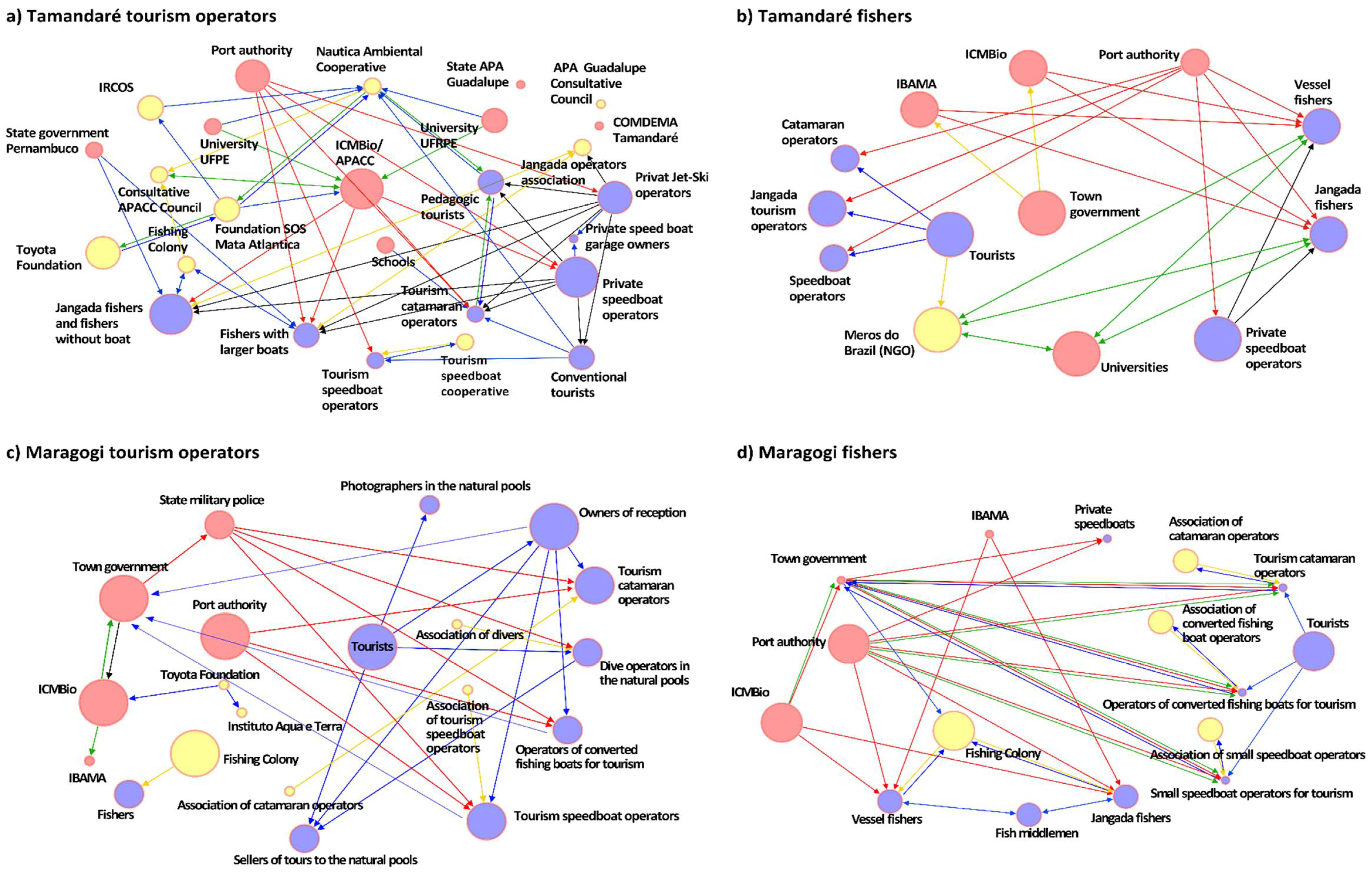
4. Results
Shared Ecosystem User Perceptions of the Governance Realm
4.1.1. Location Specific Perceptions
4.1.2. Fishers’ Perceptions
4.1.3. Tourism Operators’ Perceptions
5. Discussion
Towards Sustainability-Enhancing Regulations for the Use of Coral Reef Territories
5.1.1. Influence and Legitimacy
5.1.2. Equity
5.1.3. On the Net-Mapping Method
5.1.4. Net-Mapping as a Catalyst of Action
6. Conclusions
Author Contributions
Acknowledgments
Conflicts of Interest
Appendix A. Description of Net-Map Method as Used in this Study
Appendix B. Supplementary Electronic Material

| Actors | Tamandaré, Mentioned by | Maragogi, Mentioned by | ||
|---|---|---|---|---|
| Tourism | Fishers | Tourism | Fishers | |
| Town government | x | x | x | |
| Port authority | x | x | x | x |
| IBAMA | x | x | x | |
| ICMBio | x | x | x | x |
| State military police | x | |||
| University UFRPE | x | x | ||
| University UFPE | x | x | ||
| Schools | x | |||
| State government Pernambuco/Chapeu de Palha | x | |||
| COMDEMA | x | |||
| State APA Guadalupe | x | |||
| Consultative Council of CC-EPA | x | |||
| Consultative Council Guadalupe EPA | x | |||
| Conventional tourists | x | x | x | x |
| Pedagogic tourists | x | |||
| Tourism catamaran operators | x | x | x | x |
| Tourism speedboat operators | x | x | x | x |
| Operators of converted fishing boats for tourism | x | x | ||
| Owners of reception | x | |||
| Dive operators in the natural pools | x | |||
| Photographers in the natural pools | x | |||
| Sellers of tours to the natural pools | x | |||
| Speed boat garage owners | x | |||
| Private speedboat and jet-ski operators | x | x | x | |
| Jangada fishers | x | x | x | x |
| Vessel fishers | x | x | x | x |
| Fish middlemen | x | |||
| Fishing colony | x | x | x | |
| Association of divers | x | |||
| Association of converted fishing boat op. | x | |||
| Association of tourism speedboat operators | x | x | x | |
| Association of catamaran operators | x | x | ||
| Jangada operators association | x | |||
| Instituto Aqua e Terra | x | |||
| Toyota Foundation | x | x | ||
| Meros do Brazil (NGO) | x | |||
| Foundation SOS Mata Atlantica | x | |||
| Nautica Ambiental Cooperative, Tamandaré | x | |||
| IRCOS (Instituto Recifes Costeiros) | x | |||
Tamandaré Net-Maps (Figure 2a,b in Main Text)
Maragogi Net-Maps (Figure 2c,d in Main Text)
References
- Biermann, F.; Betsill, M.M.; Viera, S.C.; Grupta, J.; Kanie, N.; Lebel, L.; Liverman, D.; Schroeder, H.; Siebenhüner, B.; Yanda, P.Z.; et al. Navigating the Anthropocene: The Earth System Governance Project Strategy Paper. Curr. Opin. Environ. Sustain. 2010, 2, 202–208. [Google Scholar] [CrossRef]
- Alexander, S.M.; Armitage, D. A social relational network perspective for MPA science. Conserv. Lett. 2015, 8, 1–13. [Google Scholar] [CrossRef]
- Olsen, S.B.; Page, G.G.; Ochoa, E. The Analysis of Governance Responses to Ecosystem Change: A Handbook for Assembling a Baseline; GKSS Research Centre: Geesthacht, Germany, 2009. [Google Scholar]
- Brewer, T.D.; Moon, K. Towards a functional typology of small-scale fisheries co-management informed by stakeholder perceptions: A coral reef case study. Mar. Policy 2015, 51, 48–56. [Google Scholar] [CrossRef]
- Christie, P. Marine Protected Areas as Biological Successes and Social Failures in Southeast Asia. Am. Fish. Soc. Symp. 2004, 42, 155–164. [Google Scholar]
- Cicin-Sain, B.; Belfiore, S. Linking marine protected areas to integrated coastal and ocean management: A review of theory and practice. Ocean Coast. Manag. 2005, 48, 847–868. [Google Scholar] [CrossRef]
- Bodin, Ö.; Crona, B.I. The role of social networks in natural resource governance: What relational patterns make a difference? Glob. Environ. Chang. 2009, 19, 366–374. [Google Scholar] [CrossRef]
- Steiner, A. Democracy and Participation. In Global Sustainability—A Noble Cause; Schellnhuber, H.J., Molina, M., Stern, N., Huber, V., Kadner, S., Eds.; Cambridge University Press: Cambridge, UK, 2010. [Google Scholar]
- Cárcamo, P.F. Collaboration and knowledge networks in coastal resources management: How critical stakeholders interact for multiple-use marine protected area implementation. Ocean Coast. Manag. 2014, 91, 5–16. [Google Scholar] [CrossRef]
- Ferreira, B.P.; Maida, M. Monitoring Brazilian Coral Reefs, Status and Perspectives; Brasilia, Brazil, 2006. [Google Scholar]
- Prates, A.P.L.; Gonçalves, M.A.; Rosa, M.R. Panorama da Conservação dos Ecossistemas Costeiros e Marinhos no Brasil, 2nd ed.; Ministério do Meio Ambiente (MMA): Brasilia, Brazil, 2012; ISBN 9788577381425.
- Ferreira, B.P.; Maida, M. Characteristics and Perspectives for Fishery Management in the Coral Coast Marine Protected Area. In Aquatic Protected Areas as Fisheries Management Tools, Protected Areas of Brazil Series; Brazilian Institute of the Environment and Renewable Natural Resources (IBAMA): Brasilia, Brazil, 2007; pp. 39–50. [Google Scholar]
- Puppim de Oliveira, J.A. Governmental responses to tourism development: Three Brazilian case studies. Tour. Manag. 2003, 24, 97–110. [Google Scholar] [CrossRef]
- Gasalla, M.A. Do all answers lie within (the community)? Fishing rights and marine conservation. In World Small-Scale Fisheries: Contemporary Visions; Chuenpagdee, R., Ed.; Eburon Acdemic Publisher: Delft, The Netherlands, 2011; pp. 185–203. [Google Scholar]
- Gerhardinger, L.C.; Gorris, P.; Gonçalves, L.R.; Herbst, D.F.; Vila-Nova, D.A.; de Carvalho, F.G.; Glaser, M.; Zondervan, R.; Glavovic, B. Healing Brazil’s Blue Amazon: The role of knowledge networks in nurturing cross-scale transformations at the frontlines of ocean sustainability. Front. Mar. Sci. Mar. Affairs Policy 2018, 4, 395. [Google Scholar] [CrossRef]
- Juffe-Bignoli, D.; Burgess, N.D.; Bingham, H.; Belle, E.M.S.; de Lima, M.G.; Deguignet, M.; Bertzky, B.; Milam, A.N.; Martinez-Lopez, J.; Lewis, E.; et al. Protected Planet Report 2014. Tracking Progress towards Global Targets for Protected Areas; UNEP World Conservation Monitoring Centre: Cambridge, UK, 2014. [Google Scholar]
- Jones, P.J.S. Governing Marine Protected Areas: Resilience through Diversity; Routledge: Oxon, UK; New York, NY, USA, 2014. [Google Scholar]
- Wever, L.; Glaser, M.; Gorris, P.; Ferrol-Schulte, D. Decentralization and participation in integrated coastal management: Policy lessons from Brazil and Indonesia. Ocean Coast. Manag. 2012, 66, 63–72. [Google Scholar] [CrossRef]
- Roberts, C.M.; Bohnsack, J.A.; Gell, F.; Hawkins, J.P.; Goodridge, R. Effects of marine reserves on adjacent fisheries. Science 2001, 294, 1920–1923. [Google Scholar] [CrossRef] [PubMed]
- Pomeroy, R.S.; Mascia, M.B.; Pollnac, R.B. Marine protected areas: The social dimension. In Report and Documentation of the Expert Workshop on Marine Protected Areas and Fisheries Management: Review and Issues of Consideration; Food and Agriculture Organisation (FAO), Ed.; FAO: Rome, Italy, 2007; pp. 149–182. [Google Scholar]
- Rife, A.N.; Erisman, B.; Sanchez, A.; Octavio, A.-O. When good intentions are not enough. Insights on networks of “paper park” marine protected areas. Conserv. Lett. 2013, 6, 200–212. [Google Scholar] [CrossRef]
- Fox, H.E.; Mascia, M.B.; Basurto, X.; Costa, A.; Glew, L.; Heinemann, D.; Karrer, L.B.; Lester, S.E.; Lombana, A.V.; Pomeroy, R.S.; et al. Reexamining the science of marine protected areas: Linking knowledge to action. Conserv. Lett. 2012, 5, 1–10. [Google Scholar] [CrossRef]
- Walker-Springett, K.; Jefferson, R.; Böck, K.; Breckwoldt, A.; Comby, E.; Cottet, M.; Hübner, G.; Le Lay, Y.-F.; Shaw, S.; Wyles, K. Ways forward for aquatic conservation: Applications of environmental psychology to support management objectives. J. Environ. Manag. 2016, 166, 525–536. [Google Scholar] [CrossRef] [PubMed]
- Karnad, D.; Ganga, M.; Karanth, K.K. Perceptions matter: How fishermen’s perceptions affect trends of sustainability in Indian fisheries. Oryx 2013, 48, 218–227. [Google Scholar] [CrossRef]
- Hicks, C.C.; Cinner, J.E. Social, institutional, and knowledge mechanisms mediate diverse ecosystem service benefits from coral reefs. Proc. Natl. Acad. Sci. USA 2014, 111, 17791–17796. [Google Scholar] [CrossRef] [PubMed]
- Katikiro, R.; Ashoka Deepananda, K.H.M.; Macusi, E. Interplay between perceived changes in fishery and social structures in Tanzanian coastal fishing communities. Fish. Res. 2015, 164, 249–253. [Google Scholar] [CrossRef]
- Rogerson, J.J.M. Being heard: Thinking through different versions of rationality, epistemological policing and dissonances in marine conservation. Mar. Policy 2015, 60, 325–330. [Google Scholar] [CrossRef]
- Bennett, N.J. Using perceptions as evidence to improve conservation and environmental management. Conserv. Biol. 2016, 30, 582–592. [Google Scholar] [CrossRef] [PubMed]
- Beyerl, K.; Putz, O.; Breckwoldt, A. The Role of Perceptions for Community-Based Marine Resource Management. Front. Mar. Sci. 2016, 3, 238. [Google Scholar] [CrossRef]
- Gelcich, S.; O’Keeffe, J. Emerging frontiers in perceptions research for aquatic conservation. Aquat. Conserv. Mar. Freshw. Ecosyst. 2016, 26, 986–994. [Google Scholar] [CrossRef]
- Schiffer, E.; Hauck, J. Net-Map: Collecting Social Network Data and Facilitating Network Learning through Participatory Influence Network Mapping. Field Methods 2010, 22, 231–249. [Google Scholar] [CrossRef]
- Dantas, E.W.C. Metropolização turística em região monocultora industrializada. Mercator 2013, 12, 65–84. [Google Scholar] [CrossRef]
- IOC/UNESCO; IMO; FAO; UNDP. A Blueprint for Ocean and Coastal Sustainability; IOC/UNESCO: Paris, France, 2011. [Google Scholar]
- Sell-Greiser, C. Tourismus und Naturschutz: Partizipation zur Konfliktvermeidung im integrierten Küstenzonenmanagement. In Küste, Ökologie und Mensch; Glaeser, B., Ed.; Oekom: München, Germany, 2005; pp. 203–218. [Google Scholar]
- Macedo, H.S.; Vivacqua, M.; Rodrigues, H.C.L.; Gerhardinger, L.C. Governing wide coastal-marine protected territories: A governance analysis of the Baleia Franca Environmental Protection Area in South Brazil. Mar. Policy 2013, 41, 118–125. [Google Scholar] [CrossRef]
- ICMBio. Plano de Manejo da Área de Proteção Ambiental Costa dos Corais; ICMBio: Tamandaré, Brazil, 2013.
- Gorris, P. Entangled? Linking Governance Systems for Regional-Scale Coral Reef Management: Analysis of Case Studies in Brazil and Indonesia; Jacobs University: Bremen, Germany, 2015. [Google Scholar]
- Prefeitura Tamandaré Dados Geográficos. Available online: http://www.tamandare.pe.gov.br/?pag=munic_geog (accessed on 27 September 2016).
- Leão, Z.M.A.N.; Kikuchi, R.K.P.; Ferreira, B.P.; Neves, E.G.; Sovierzosky, H.H.; Oliveira, M.D.M.; Maida, M.; Correia, M.D.; Johnsson, R. Brazilian coral reefs in a period of global change: A synthesis. Braz. J. Oceanogr. 2016, 64, 97–116. [Google Scholar] [CrossRef]
- Bastian, M.; Heymann, S.; Jacomy, M. Gephi: An open source software for exploring and manipulating networks. In Proceedings of the International AAAI Conference on Weblogs and Social Media, San Jose, CA, USA, 17–20 May 2009. [Google Scholar]
- Bernard, R.H. Research Methods in Anthropology: Qualitative and Quantitative Approaches, 4th ed.; AltaMira Press: Oxford, UK, 2006. [Google Scholar]
- Deutsche Forschungsgemeinschaft (DFG). Sicherung Guter Wissenschaftlicher Praxis: Empfehlungen der Kommission “Selbstkontrolle in der Wissenschaft”; Wiley-VCH Verlag GmbH & Co. KGaA: Weinheim, Germany, 2013; ISBN 9783527337033. [Google Scholar]
- Clayton, S.; Myers, G. Conservation Psychology: Understanding and Promoting Human Care for Nature; Wiley-Blackwell: West Sussex, UK, 2009. [Google Scholar]
- Gallagher, S.; Zahavi, D. The Phenomenological Mind, 2nd ed.; Routledge: Oxon, UK; New York, NY, USA, 2012. [Google Scholar]
- Steg, L.; van den Berg, A.E.; de Groot, J.I.M. Environmental psychology: History, scope and methods. In Environmental Psychology; Steg, L., van den Berg, A.E., de Groot, J.I.M., Eds.; Wiley-Blackwell: Oxford, UK, 2013; pp. 1–12. [Google Scholar]
- Gerrig, R.J.; Zimbardo, P.G. Psychology and Life, 18th ed.; Allyn and Bacon: Boston, MA, USA, 2008. [Google Scholar]
- McClanahan, T.R.; Maina, J.; Davies, J. Perceptions of resource users and managers toweards fisheries management options in Kenyan coral reefs. Fish. Manag. Ecol. 2005, 12, 105–112. [Google Scholar] [CrossRef]
- Jefferson, R.; McKinley, E.; Capstick, S.; Fletcher, S.; Griffin, H.; Milanese, M. Understanding audiences: Making public perceptions research matter to marine conservation. Ocean Coast. Manag. 2015, 115, 61–70. [Google Scholar] [CrossRef]
- Grothmann, T.; Patt, A. Adaptive Capacity and Human Cognition: The Process of Individual Adaptation to Climate Change. Glob. Environ. Chang. 2005, 15, 199–213. [Google Scholar] [CrossRef]
- Vodden, K.; Bannister, K. Circularizing Knowledge Flows: Institutional Structures, Policies, and Practices for Community-University Collaborations. In Making and Moving Knowledge: Interdisciplinary and Community-Based Research in a World on the Edge; Sutton Lutz, J., Neis, B., Eds.; McGill-Queen’s University Press: Montreal, QC, Canada; Kingston, ON, Canada; London, UK; Ithaca, NY, USA, 2008; pp. 245–270. [Google Scholar]
- Pomeroy, R.S.; Berkes, F. Two to tango: The role of government in fisheries co-management. Mar. Policy 1997, 21, 465–480. [Google Scholar] [CrossRef]
- Berghöfer, A.; Wittmer, H.; Rauschmayer, F. Stakeholder participation in ecosystem-based approaches to fisheries management: A synthesis from European research projects. Mar. Policy 2008, 32, 243–253. [Google Scholar] [CrossRef]
- Gerhardinger, L.C.; Godoy, E.A.; Jones, P.J.S. Local ecological knowledge and the management of marine protected areas in Brazil. Ocean Coast. Manag. 2009, 52, 154–165. [Google Scholar] [CrossRef]
- Stein, C.; Ernstson, H.; Barron, J. A social network approach to analyzing water governance: The case of the Mkindo catchment, Tanzania. Phys. Chem. Earth 2011, 36, 1085–1092. [Google Scholar] [CrossRef]
- Hauck, J.; Stein, C.; Schiffer, E.; Vandewalle, M. Seeing the forest and the trees: Facilitating participatory network planning in environmental governance. Glob. Environ. Chang. 2015, 35, 400–410. [Google Scholar] [CrossRef]
- Gorris, P. Deconstructing the Reality of Community-Based Management of Marine Resources in a Small Island Context in Indonesia. Front. Mar. Sci. 2016, 3, 120. [Google Scholar] [CrossRef]
- Ferreira, B.P.; Messias, L.T.; Maida, M. The Environmental Municipal Councils as an Instrument in Coastal Integrated Management: The Área de Proteção Ambiental Costa dos Corais (AL/PE) Experience. J. Coast. Res. 2006, 39, 1003–1007. [Google Scholar]
- Turner, R.A.; Forster, J.; Fitzsimmons, C.; Gill, D.; Mahon, R.; Peterson, A.; Stead, S. Social fit of coral reef governance varies among individuals. Conserv. Lett. 2017, e12422. [Google Scholar] [CrossRef]
- Gerhardinger, L.C.; Godoy, E.A.; Jones, P.J.S.; Sales, G.; Ferreira, B.P. Marine protected dramas: The flaws of the Brazilian National System of Marine Protected Areas. Environ. Manag. 2011, 47, 630–643. [Google Scholar] [CrossRef] [PubMed]
- Adger, W.N.; Brown, K.; Tompkins, E.L. The Political Economy of Cross-Scale Networks in Resource Co-Management. Ecol. Soc. 2006, 10, 9. [Google Scholar] [CrossRef]
- Alexander, S.M.; Andrachuk, M.; Armitage, D. Navigating governance networks for community-based conservation. Front. Ecol. Environ. 2016, 14, 155–164. [Google Scholar] [CrossRef]
- Alexander, S.M.; Epstein, G.; Bodin, Ö.; Armitage, D.R.; Campbell, D. Participation in planning and social networks increase social monitoring in community-based conservation. Conserv. Lett. 2018, in press. [Google Scholar] [CrossRef]
- Bodin, Ö. Collaborative environmental governance: Achieving collective action in social-ecological systems. Science 2017, 357. [Google Scholar] [CrossRef] [PubMed]
- Figuereido, M. Promotion and Management in Marine Fisheries in Brazil. In Towards Sustainable Fisheries Law. A Comparative Analysis; Winter, G., Ed.; International Union for Conservation of Nature (IUCN): Gland, Switzerland, 2009; pp. 187–232. [Google Scholar]
- Diegues, A.C. Marine Protected Areas and Artisanal Fisheries in Brazil; International Collective in Support of Fishworkers (Samudra Monograph): Chennai, India, 2008. [Google Scholar]


| Data Collection Method | Main Objectives | Participants |
|---|---|---|
| Local policy review | understand the currently implemented management measures to ensure sustainable use of the coral reefs | - |
| Key informant interviews | examine recent development in the region’s coral reef use understand whether the CC-EPA’s rules and regulations implemented in the study areas are complied with | Interviews were conducted with key persons involved in developing the CC-EPA management plan (n = 3), tourism operators (n = 2), fishers (n = 3) and NGO personnel (n = 1) |
| Participant observation | learn about coral reef use and management in practice | - |
| Net-map sessions | elicit the perceptions of ecosystem users of the formal and informal relations between actors in coral reef governance | A group interview was conducted with fishers (n = 6) and tourism operators (n = 2) in Tamandaré, and with fishers (n = 5) and tourism operators (n = 3) in Maragogi |
| Fishers | Tourism Operators | Totals | |
|---|---|---|---|
| Tamandaré | |||
| Government | 5 | 8 | 10 (36%) |
| Private sector | 7 | 7 | 8 (29%) |
| Civil Society | 1 | 8 | 10 (36%) |
| Total | 13 | 24 | 28 |
| Maragogi | |||
| Government | 4 | 4 | 5 (21%) |
| Private sector | 8 | 9 | 12 (50%) |
| Civil Society | 4 | 5 | 7 (29%) |
| Total | 16 | 18 | 24 |
© 2018 by the authors. Licensee MDPI, Basel, Switzerland. This article is an open access article distributed under the terms and conditions of the Creative Commons Attribution (CC BY) license (http://creativecommons.org/licenses/by/4.0/).
Share and Cite
Glaser, M.; Gorris, P.; Ferreira, B.P.; Breckwoldt, A. Analysing Ecosystem User Perceptions of the Governance Interactions Surrounding a Brazilian Near Shore Coral Reef. Sustainability 2018, 10, 1464. https://doi.org/10.3390/su10051464
Glaser M, Gorris P, Ferreira BP, Breckwoldt A. Analysing Ecosystem User Perceptions of the Governance Interactions Surrounding a Brazilian Near Shore Coral Reef. Sustainability. 2018; 10(5):1464. https://doi.org/10.3390/su10051464
Chicago/Turabian StyleGlaser, Marion, Philipp Gorris, Beatrice Padovani Ferreira, and Annette Breckwoldt. 2018. "Analysing Ecosystem User Perceptions of the Governance Interactions Surrounding a Brazilian Near Shore Coral Reef" Sustainability 10, no. 5: 1464. https://doi.org/10.3390/su10051464
APA StyleGlaser, M., Gorris, P., Ferreira, B. P., & Breckwoldt, A. (2018). Analysing Ecosystem User Perceptions of the Governance Interactions Surrounding a Brazilian Near Shore Coral Reef. Sustainability, 10(5), 1464. https://doi.org/10.3390/su10051464