1. Introduction
Accompanying the changes in global society, economy, and environment, the methods of land use are being altered constantly, the current model of agricultural intensification is strengthened, and the conflicts between urban and rural development are gradually emerging [
1,
2]. Sustainable development tools are needed for further improvement of the life quality in human settlements and the coordination of the man–land relationships [
3]. The UN 2030 Agenda for Sustainable Development proposed 17 Sustainable Development Goals (SDGs) and 169 specific targets aimed at addressing social, economic, and environmental issues in sustainable development in an “inclusive, safe, resilient, and sustainable” manner. Presently, human settlements are where conflicts between man and nature are most obvious. Sustainable development is an imperative measure for both urban and rural areas [
4,
5]. Measures should be taken in the protection and promotion of the sustainable use of terrestrial ecosystems, sustainable management of forests, prevention of land degradation to promote sustainable agricultural development, and make cities and human settlements more inclusive, safe, adaptive, and sustainable [
6] to achieve a harmonious and co-prosperous state between man and the natural environment. The ecological perspective of the harmonious development of man and land emerged from the background of the ecological crisis of the 1960s. Discussed in his classic book
Design with Nature, McHag [
7] established the research framework of ecological planning to coordinate the relationship between people and nature in a developed area. Currently, this theory has been continuously developed and widely used in the ecological research and design of architecture, landscape, and urban and rural spaces around the world, including sustainable ecological planning [
8,
9], ecological construction of sustainable communities [
10,
11], and landscape security pattern [
12,
13], etc.
Recently, in various thoughts about the harmonious development of humans and land, there has been a debate over the economics of sustainable development. Some scholars believe that the economic development model aiming at GDP (gross domestic product) growth would bring multiple environmental, economic, and social crises on a global scale. To respond to this issue, scholars propose to adopt a fundamental change of “de-growth”, which does not regard economic growth as the ultimate goal, but aims to control consumption and development instead, thus achieving ecological sustainability, social equity, and culture revival [
14,
15]. A clear definition of sustainable growth is stated in the International Economic De-growth for Ecological Sustainability and Social Equity Conference in Paris in 2008: proceeding on a local or global scale, with short-term or long-term scales, fair production, and a shrunken consumption scale accompanied by an increase in human welfare [
16]. Serge Latouche [
17], the representative of this theory, proposed that the most important way to achieve de-growth is “relocating”. Specifically, the macroscopic concept of de-growth and re-localization can be interpreted from the three aspects of ecology, economy, and politics: the closed energy cycle of a simulated ecosystem at the ecologic level, the self-sufficient local economy at the economic level, and the dispersion of support in highly democratic decision-making [
18]. The ecovillage movement that originated in the late 20th century is the practice of the de-growth theory [
19].
The traditional settlements arising from the period of low economic levels have always been consistent with the regional environmental capacity in the process of developing and utilizing resources, in fact, and have achieved a state in which the economic development level is consistent with the carrying capacity of the ecological environment through the development of sustainable livelihood models and the formulation of village rules and regulations that control development. Via the original manifestation of the idea of sustainable de-growth, traditional villages lived in harmony with nature over the past thousands of years, and the traditional wisdom of construction is embodied in the developed space, ecosystem, and social politics of the settlement. Traditional villages are the product of nature, culture and man, and the fruit of human adaptation to nature and transformation of nature [
20,
21]. Some villages, having a long history of having withstood a variety of ecological tests and having achieved sustainable development, are particularly worthy of study. Their ecologically sustainable ideals can be the guide and reference of sustainable development for future human settlements [
22,
23]. Villages constructed in harsh habitats can interpret the characteristics of sustainable development more comprehensively. Due to the steep terrain, the distribution of mountain village settlements is closely related to natural conditions [
24]. Facing the challenges of scarce farmland, difficulties in water resource utilization, and frequent natural disasters [
25,
26], humans are required to consider natural adaptation and co-prosperity in their construction process. Current research on the sustainability of mountain villages is focused on sustainable livelihoods [
27,
28]. Sustainable livelihoods are livelihoods that can respond to and recover from stress and shock, and can maintain and even strengthen their capabilities and assets, both now and in the future, without compromising the natural resource base [
29]. Comprehensive study of the ecological capacity of mountain villages, livelihood strategies and livelihood capital can help further evaluation and exploration of integrated analytical frameworks and sustainable development frameworks. Cortijos, one of the most distinctive rural settlement types in southern Spain, is studied by Infante–Amate [
30], who analyzed the evolution of scattered settlements and the geographical and historical causes of their rise and fall, for example; Constantin [
31] gained an in-depth understanding of the way(s) rural mining settlements located in the Apuseni Mountains cope and respond (resilience) and adjust and adapt to exposure beyond the political, institutional, and socio-economic restructuring; Gentle [
32] used a climate vulnerability and capacity analysis (CVCA) process to analyze major climate hazards and their effects on livelihood resources in the rural area in Nepal; Fukamachi [
33] examined governmental policy for the conservation of biocultural diversity in satoyama landscapes with traditional terraced paddy fields, and efforts for sustainability of terraced paddy fields, at the local level shown by the example of a rural and a suburban area. Recently, Pitts and Gao [
34,
35] have done extensive research of villages in Yunnan Province. The existing results show that these villages need to consider the sustainable development of the current challenges based on their historical and natural context, while the technologies, techniques, and mechanisms are important issues. As the understanding of ecosystem mechanisms and processes continues to deepen, humans are constantly reflecting on their own behaviors and development models. Many scholars have found that traditional knowledge is closely related to the basic assumptions of sustainability and can be considered an important guidance in sustainable research for modern people. They advocate traditional indigenous knowledge to be integrated into conservation and ecological restoration planning [
36,
37]. Kakoty [
38] proposes that the traditional knowledge systems of the Khasi traditions, and examination of the Khasi sacred forest, holds important lessons for overcoming some of the major problems of the present world. Pio-Leon [
39] established the wild edible plants used by the inhabitants of the Biosphere Reserve Sierra la Laguna, in México, and identified priority plant edible species for sustainable use to improve the income of local people. Traditional ecological knowledge represents the experience gained by human beings living in the natural environment for thousands of years [
40] and a unique production and lifestyle formed under the influence of different regions and ethnic groups. This body of knowledge also includes long-term and close regional observations. Local people are associated with their land in a complex and intimate way. The depth of thinking and practice cannot be matched by current research [
41]. Camacho [
42] describes the different knowledge systems for natural resources management in the Cordillera as practiced by the people with different beliefs, culture, and traditions, which could be very good models for promoting forest sustainability. Neyra–Cabatac [
43] finds in the Erumanen community in the South Philippines that integration of certain traditional practices might prove relevant in developing approaches that would conserve natural resources and warrant food security. Jiao and Gu [
44,
45] argue that Hani ethnic groups use local ecological knowledge to protect their local rice species from diseases and promote management of forest-water systems and soil resources. The long-term sustainability of the Hani Rice Terraces depends on the socio-cultural resilience of their custodian communities.
Ethnic groups living in mountainous villages located in southwestern China are also typical examples of mountainous sustainable human settlements. Take the Dong village in southeastern Guizhou as an example. The Dong people’s ancestors moved up the river from the plains of the downstream river network hundreds of years ago and eventually settled in the mountain valleys in this area. Focused on maintaining the livelihood of “rice farming”, the Dong people constantly adapted to and modified the natural environment and developed a coordinated ecological-humanistic system by forest, villages, paddy fields, and water systems, forming a unique village pattern and shape reflecting the ecological wisdom of symbiosis of human and land, which is a good reference for sustainable development. The academic research of the early academic circles on the settlements of ethnic minorities in southwest China originated from the investigation reports of anthropology and ethnology. The research mainly focused on the history and culture of ethnic minorities in the region, as well as the records and research on the distribution of settlements and typical buildings, which has a high value in documentation [
46,
47]. The study of the southwestern ethnic settlements in the field of architecture, planning, and landscape originated from the study of individual buildings of various national characteristics such as dwellings, drum towers, “wind and rain bridges”, and research on the residential mode and residential system of the Dong settlements through surveying, spatial analysis, and graphical analysis [
48,
49]. The current research focuses on the overall system between dwellings, settlements and the natural, social, and cultural environment, where multidisciplinary perspectives are gradually integrated in research methods. Taking the research on the Dong settlement in this area as an example, some studies start from the social and cultural background. Yang [
50] combines the architectural techniques and culture of the Dong people to compare the settlements of the southwestern ethnic groups to that of Southeast Asia and explores the evolution system of architecture and villages. Zwerger [
51] discusses the technology development of Dong construction under the farming culture and summarizes the regional cultural differences behind the built environment. Taking the perspective of cultural heritage protection and development, Cai [
52] analyzes the characteristics of the Dong settlements from the perspective of architectural form, settlement space, and national culture, based on the survey data of several villages, and puts forward the concept of an “architectural culture zone”. Based on the theory of living heritage, Zhao uses the Dong settlement as an example to explore the research and protection method of the living vernacular settlements from the three levels of settlement groups, settlements, and single buildings [
53]. Yu [
54] and Fang [
55] studied the characteristics of the Dong people’s settlement, culture, and protection from the perspective of the Dong “ecological museum” construction. Starting from the theory of settlement landscape genes, Yang [
56] identified the landscape genes of the Dong people as four factors, namely Drum Tower, the Satan, the surrounding of the Drum Tower, and the forest and ponds based on the landscape gene theory of traditional settlement and studied the relationship between the landscape and the local identity construction of the Dong village. It is not difficult to find that the main perspectives and methods of previous research are from anthropology, architecture, and other aspects, putting emphasis on the description of facts and the summarization of experience.
Recently, with the deepening ideas of rural sustainable development, the emphasis of research has begun to focus on settlements, architectural spaces, and human settlement ecosystems. Especially under the influence of “re-localization” in the abovementioned sustainable development “degrowth”, it is obviously an important issue to explore and explain the sustainable concept embedded in the construction of local settlements. The unique topography and hydrological conditions in the region attracted the attention of scholars first. Zhu, Wang, and Zhou [
57,
58,
59] focused on the close relationship between the Dong settlement and the water system and water landscape in the mountainous areas. It is proposed that the Dong settlement is a product of harmonious co-construction of humans, natural terrain, and the hydrological environment. Taking the traditional view of Fengshui and the ecological niche, Song [
60] explores the complex ecosystem formed under the influence of the natural mountainous and hydrological environment, and economic and cultural factors in the Dong village. Lü [
61] and Xiong [
62] used a method of ecosystem service value evaluation and ecological footprint, to conduct a regional ecological environment assessment, planning and research, with a focus on biodiversity, land and water resources, and national history and culture. Additionally, ecological anthropologists also have contributed an important research perspective that specific traditional livelihood models have an important impact on the formation of sustainable spatial models of settlements [
63,
64]. The above-mentioned literature still has a relatively simple vision, however, and the topography and hydrological conditions constitute the basic conditions of ecology. The Dong ancestors who have settled here historically have adapted to, and moderately transformed, the basic conditions forming a harmonious “human–land” traditional livelihood model. Three factors, the natural geographical environment of the mountain as a basement for the survival of the settlement, the hydrological environment formed by various natural and artificial rivers, streams and dams, and the livelihood model reflecting the Dong people’s ideal, together form a settlement space, where mountains, forests, farmland, rivers, and villages interact with each other in a dependent settlement ecological landscape. It is urgent, therefore, to integrate the perspectives and methods of geography, architecture, and anthropology to examine the historical process of settlement construction in the region, to clarify the overall structure and characteristics of the settlement space model that reflects the sustainable development concept of “de-growth”.
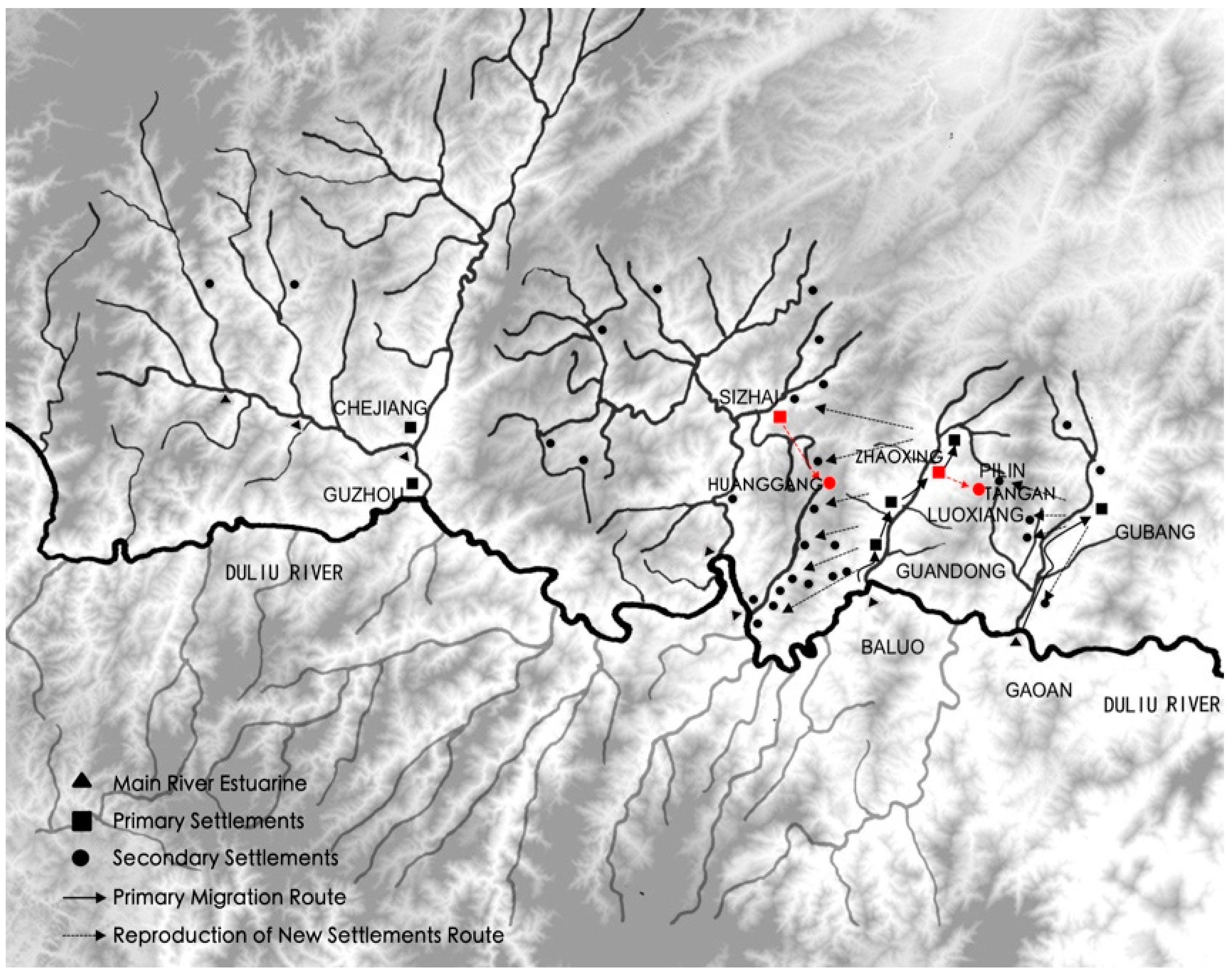
This study took the Dong village in the Duliujiang River Basin in Southeastern Guizhou as an example (
Figure 1), traced the complete process of historical construction, and then systematically revealed a variety of thoughts and practices considering sustainability at all stages of construction. Through the comprehensive analysis of the topography and hydrological conditions in the Duliujiang River Basin, the migration process and rice farming system of the Dong people in the area were organized. The two groups of closely associated typical villages, the Zhaoxing–Tang’an group and the Sizhai–Huanggang group, were taken as examples to analyze the construction model of mountain villages in the Nandong Region, as well as the ecosystem and corresponding sustainable management methods, which could provide a reference for the sustainable development of future villages.
3. Result: The Historical Formation Process of Village Groups and Village Types
Through hundreds of years of continuous construction, the Duliujiang River Basin has gradually formed thousands of Dong villages. These villages share common cultural characteristics and there is a common blood relationship between them, thus, typical Dong settlement groups are formed within a radius of several hundred kilometers. During different historical periods, however, different natural conditions, especially the limitation of topography and hydrological conditions, influenced the formation of typical types of villages which mainly can be divided into flat river valley type, mountain valley type, and mountain slope type. There are large differences in the various types of ecological and environmental conditions, which causes a significant gap in the available living space. While the larger one accommodates the survival and development of thousands of villagers, the small one can meet only the survival needs of dozens, but each has formed a stable and sustainable relationship between man and nature.
3.1. The Dong Village Group in Southeast Guizhou Formed through Evolution
Through the analysis of ancient songs and other text materials, combined with the field visit investigation, the study found that the formation of the Dong villages in the Duliujiang River Basin followed a sequence of time. It can be seen clearly that the development order is from downstream to upstream, from river valleys to hilly area and then to the deep mountainous areas.
According to the relationship of bloodline and the construction sequence of the villages, the villages are divided into “primary settlements” and “secondary settlements” (
Table 1). Primary settled villages are places where people first chose to settle, which is the base. Following several generations, people would choose other places to settle, which are secondary settled villages. The “primary settlements” are usually located in relatively flat river valleys at the upstream of larger tributaries of the Duliujiang River, or along the small- and medium-sized tributaries. These flat river valleys can be further divided into wide river valleys and narrow river valleys, according to their size. The width of the wide river valley is generally more than 1 km, with a length along the river of several kilometers. The flat terrain, large and smooth water flow offers the most favorable condition for the farmland in the Nandong mountain area. The width of the narrow river valley is around several hundred meters and the length is several kilometers. The terrain in the central area is relatively flat, so the river flow is relatively slow, which is suitable for agriculture. The secondary settled villages usually migrate from the primary settled villages upstream and into the mountain, mostly small basins or mountainside slopes surrounded by mountains with relatively high altitude, which requires abundant spring water or stream water to facilitate irrigation and living in the village. The mountain top is usually covered with thick forest for water conservation. The mountain valley villages and the mountain slope villages are usually derived from the primary villages located in the flat river valley, which are blood-related. They have a relatively late construction time and a small scale. The result of the continuous reproduction of this primary village is the formation of a village system in the region consisting of several villages that are blood-related to each other (
Figure 4).
The natural geographical environment and hydrological conditions of the mountain are important factors that restrict the location of the Dong settlement. Through the analysis of the topographic hydrological environment of the study area and the distribution statistics of different migration batches under different natural conditions, differences can be found between the primary settlements and secondary settlements due to the different altitude, slope, and river buffer condition.
3.1.1. Altitude Analysis
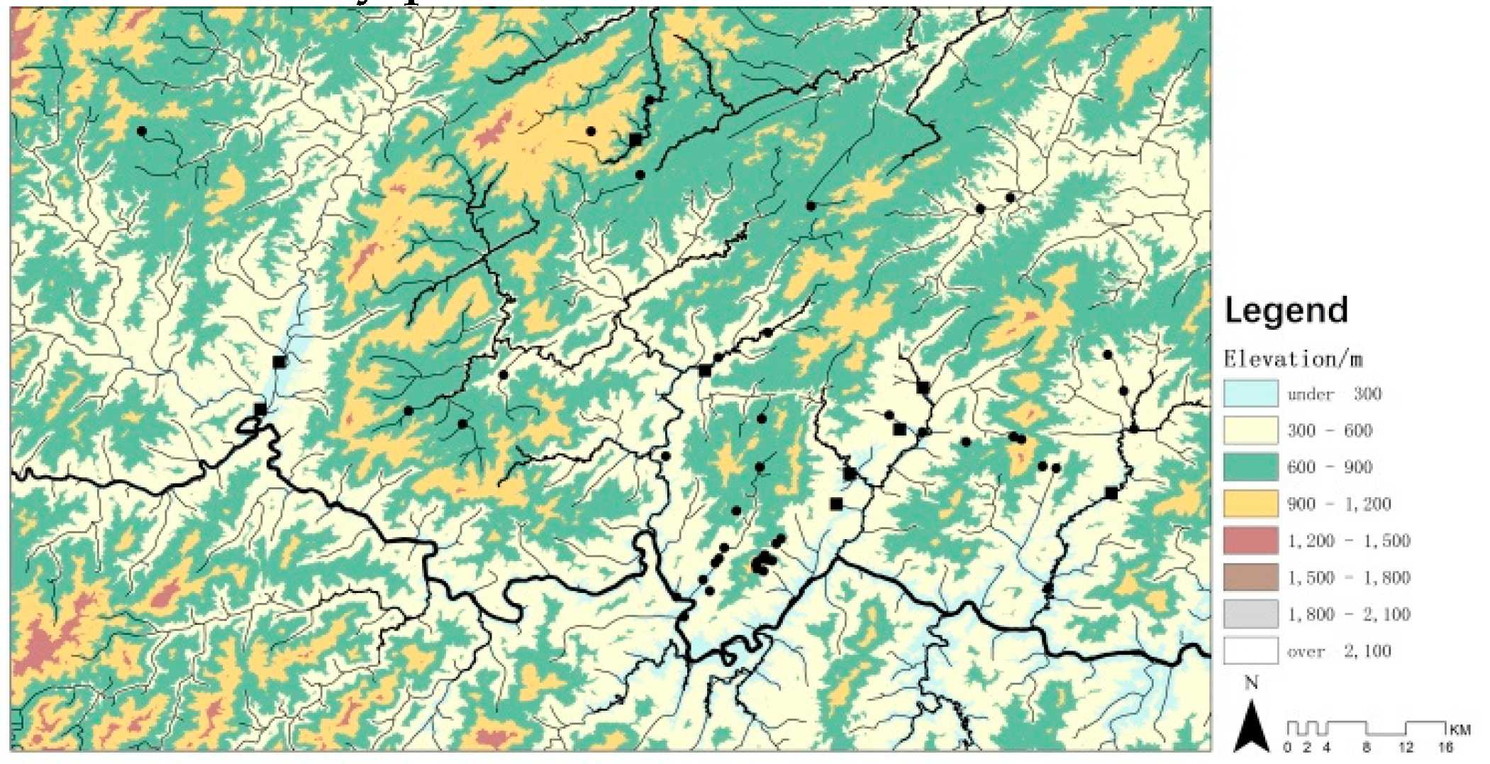
Altitude is an important attribute of natural geospatial space. The natural conditions, including climate, temperature, water source, and light intensity are different at different altitudes. It can be drawn from the regional elevation analysis chart (
Figure 5). Although the overall area of the Nandong area is in the middle of the mountain, mainly at an altitude of 400–800 m above sea level, the mountain above 600 m occupies 70% of the whole area. The fact is that most of the Dong settlements are distributed in low-altitude river valley plains.
According to the migration settlement batch and elevation box diagram (
Figure 6), the primary settlements are distributed between 230–380 m, except for Dimen which is located at an altitude of 736 m with an average elevation of 259 m; the secondary settled settlements mainly are distributed between 180–990 m, with the average elevation at 553 m. The altitude distribution of secondary settled settlements is higher than that of primary settled settlements and most of them are distributed in high altitude areas between 500–900 m. Most of the primary settled settlements are distributed in low altitude areas below 260 m. The primary settled settlements, therefore, generally occupy the low-altitude valley dam or are adjacent to the foot of the mountain, while the secondary settled settlements mostly migrate to the mountainside or the mountaintop.
3.1.2. Slope Analysis
Slope is an indicator of the degree of fluctuation of the surface of the earth and is an important factor affecting the difficulty of village construction. Most of the terrain in the Nandong area is above 15°, and several rivers extending from the Duliu River are cut longitudinally while the terrain is undulating. The Dong settlements are distributed mainly in the gently sloping plain areas of 15° and below (
Figure 7). According to the box diagram of the migration settlement and slope relationship (
Figure 8), the primary settled settlement has a slope range of 1–10° and an average slope of about 8°; the secondary settled settlement has a slope range of 1–26°, and the average slope is about 10°. Primary and secondary settled settlements are concentrated in the gentle slope area of about 10°. The slope has a large restriction on the site of the Dong settlement, therefore, and the Dong people generally choose to settle and thrive in the valley or mountainside area where the terrain is relatively flat.
3.1.3. River Buffer Zone Analysis
The Dong people are people who live by water. The development of settlements is inseparable from the water source. The distance from the water source directly affects the convenience of water source utilization, therefore, the ArcGIS buffer module is used to establish a water source buffer zone at a distance of 50 m, 100 m, 200 m, 1000 m, and more than 1000 m, combined with different river grades. It can be obtained from the analysis of the regional river buffer zone (
Figure 9), the main water system of the Duliujiang River basin. The buffer zone of the tributary water system basically covers the distribution point of the village, and Dimen and its secondary settlements also are located in the buffer zone of the Qingshui River basin.
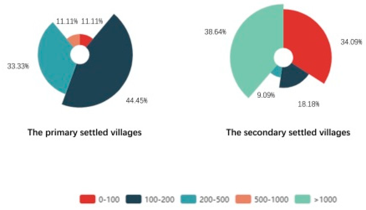
According to the wind rose diagram of the migration settlement batch and river buffer zone (
Figure 10), the number of primary settlement points reach a peak level in the 100–200 m radius of the river buffer, accounting for 44.45% of the total settlement points; followed by those in the 200–500 m river buffer radius, taking up 33.33% of the total points; the secondary settled settlements are mostly distributed in the distance of 1000 m away from the water source, accounting for 38.64%, followed by those in the 0–100 m radius of the river buffer, accounting for 34.09% of the total. The primary settled settlements are within a distance of 100–500 m from the river, and the distribution is relatively balanced, indicating that the primary settlements chose sites within a reasonable buffer zone, which not only ensured the safety of the village, but also rationally controlled the transportation cost of resources. Overall, the settlements 1000 m away from the water source are found the most, and all of them are secondary settled settlements. The reason is that the ten Dong settlements, such as Meide, Buxia, Minzhu, Tang’an, and Xiage are located on the top of the mountain, and the remaining Dong settlements cannot avoid settling in the river buffer zone at the end of the Duliujiang and Qingshui River tributaries. This large difference in site selection reflects the limitations in site selection of the secondary settlement caused by resource competition. Many settlements can only migrate to deeper mountainous areas more remote from the main river. Additionally, the fact that the distribution ratio falls as the radius of the buffer expands reflects the pattern that the distribution of the settlement becomes less as the distance to water source increases. It can also prove that the location of the Dong village still needs to consider the existence of a water source.
Generally, the study area is located in the middle zone of the mountain with a relatively higher altitude. The terrain is severely cut by the river and with dramatic undulations. The Dong settlements usually are located in the flat river valley near the river, where the primary settlements mostly are built along the main river and the main stream. They occupy the flat dam area with low elevation, low slope, and a moderate distance from the river, while the secondary settlements had to move along the tributaries to deeper mountainous areas, forming clusters on the mountainside or at the top of the mountain. This can be explained from the historical process of construction, that is, the first ancestors of the Dong nationality first occupied the valley plain with superior farming conditions, and where the topography and hydrological conditions were more suitable. Once the population continued to multiply, the subsequent settlements needed to move to areas with a steeper terrain, and more complicated water source acquisition and utilization. The livelihood mode adapted, and the settlement space adjusted accordingly, thus a spatial pattern of “localized” sustainable development formed.
Concurrently, the primary settled villages located in the flat river valley often formed a relatively close geographical connection with the secondary settled villages that were derived from the former. The following will focus on two groups of four villages of Sizhai–Huanggang Village, Zhaoxing–Tangan Village, which formed three types after adjustment. Among them, the Sizhai Village (260 m above sea level) in a flat river valley has developed a series of secondary villages, including Huanggang Village (760 m above sea level) located in the mountain valley, and the elevation climbed from 260 m in Sizhai to 760 m in Huanggang. Zhaoxing (410 m above sea level), in the river valley, has undergone multiplication and differentiation and its descendants have further built a number of secondary settlements in the mountainside area, such as the Tang’an (930 m above sea level).
3.2. Primary Village: Zhaoxing, Sizhai, located in Flat River Valley
Located along the tributary of the Luoxiang River, Zhaoxing is a large-scale ancestral home of the Dong people in several small and medium-sized villages. It can be regarded as a typical primary settled village in the valley. The narrow river valley where Zhaoxing is located is about 200 m wide and 2 km long. It is surrounded by mountains, which are above 800 m above sea level in the south, east and north. The Zhaoxing River and the Jilun River pass through the village and flow to the foot of the mountain into the Baluo River. The mountain forms a natural barrier that protects the village from natural disasters and external enemies, while the river provides sufficient water for the village. The ancestors of Zhaoxing Village have formed a series of village construction processes, from topography investigation, village site selection, layout planning, canal system construction, paddy field building, forest conservation, house building, etc., and, finally, formed a “mountain–water–paddy fields–forest-village” spatial pattern with distinct characteristics of the Dong people. Occurring at the beginning of the construction, the flat river valley was organized so it could be farmed and inhabited. The main task was to shape the water system to form irrigation channels and to open the fields. The first was to divert water from upstream into the ditches, or to divert water from the stream from the surrounding ravines, so the water could flow to the fields in the valley dam. Aligned with these moves, the opening of the rice fields also was carried initially out in the village. Accompanying the expansion of the population, Zhaoxing has finally developed five relatively independent family groups, connected end-to-end and organically arranged along the valley, forming the whole of the village (
Figure 11).
The size of Sizhai Village is slightly smaller and is located in a mountain valley also. The Sizhai River and its tributaries meet there and form a flat river valley whose scale is about five kilometers in length and 0.1 km to 0.6 km in width. The valley is surrounded by mountains and the terrain is steep. The eastern peak is over 600 m above sea level. Its height difference with the flat river valley is more than 400 m. There are a series of Dong villages including Sizhai in the valley. To preserve the scarce farmland to the largest degree, the villages were built close to the foot of the mountain and expand up the mountainside. These were connected with lush forests, while the cultivated land occupied almost the entire area of the valley. The initial site of Sizhai Village was on the north bank of the river mouth and was small in scale. Later, as the population continued to multiply, the external populations moved inside the village boundary. Through the construction of several generations, the current pattern of Sizhai village, crossing the Sizhai River, was finally formed. There are three clan groups in Dazhai on the North Bank and one clan in Xiaozhai on the South Bank. The village grew along the landscape and the texture was dense. The Sizhai River has abundant water flow, so the Dong people could provide a stable water source for the cultivated land and daily life of the village by building water conservancy dams and other water conservancy facilities.
The fields of Zhaoxing and Sizhai are located outside the village, along the rivers where the land is relatively flat. The area of farmland between the river valley is limited. To reduce occupation of farmland, the village was extended from the foot of the mountain to the mountainside at the curved riverbed terrace, according to the topography and water potential, and the internal structure was tightly organized. The fengshui forests consist of plants such as cedar trees, pine cypresses and bamboos, were planted on the north and south and in the back hills of the villages. They have an important role in conserving water sources and preventing geological disasters (
Figure 12).
3.3. Secondary Settled Village: Huanggang Village, Located in the Small Basin between Mountains
Huanggang can be considered as a typical representative of a secondary settlement located in a mountain basin. It is widely believed that the earliest villagers in Huanggang Village moved from Sizhai. When the fields and residential land around Sizhai became increasingly dense, several villagers discovered a small basin between the mountains a few kilometers away from Sizhai, where they settled and eventually prospered into today’s Huanggang Village.
Huanggang is located in a valley surrounded by mountains. The village is more than 700 m above sea level and the surrounding mountains are as high as 900 m. Huanggang River, merged by several streams in the valley that originated from the surrounding mountains, passes through the village, runs by the north side of the valley and flows into the Sizhai River. The entire small basin in the mountain covers an area of about 300 mu (1 mu = 0.0667 hectares). The biggest problem facing the alpine basin was the instability of hydrological conditions. Concentrated precipitation might easily bring the mountain floods, whereas without rain in a few days, the stream would stop flowing. To respond to this situation, Huanggang Village focused on the active but moderate transformation of the mountain stream system in the village. The Huanggang ancestors had three main ways to transform the mountain stream.
First, the ancestors built a large number of small-scale ponds in the upper reaches of the mountain stream to maintain water at the source, supply irrigation to adjacent paddy fields, and regulate downstream water volume. Regarding small creeks commonly scattered in the mountains, Huanggang villagers built many small ponds at the source or upstream by means of weir and drainage and opened alpine terraces at appropriate locations below the ponds so the water in the ponds could be used for irrigating these paddy fields. Concurrently, many small ponds located upstream played a comprehensive role in the regulation of the Huanggang River flowing through the village.
Second, the ancestors constructed deep paddy fields to achieve comprehensive functions such as storage, usage and regulation. The height of the dike in the rice fields of Huanggang Village is often more than 50 cm, far exceeding the height of the paddy fields in the flat valley. During the rainy season it could hold large quantities of rainwater, while in the winter, the water is reserved for spring use. Each paddy field has both functions of storing and using water for irrigation as a result, and it can also regulate the water level of downstream creeks, ponds, and fields.
Third, a large number of ponds–paddy fields mixed systems are built in the valley area where Huanggang is located, which has multiple functions of production, water conservation, and flood control. There are many mountain streams in the valley and it is necessary to guard against the danger of flooding when using water. The villagers of Huanggang, therefore, store and retain the mountain stream by damming and diverting water into the low-lying land. Simultaneously, they can also play a role in flood diversion when flash floods strike.
Through the above transformation of the water system, combined with the technical foundation of the previous field construction, Huanggang formed a “Stream–pond–paddy field” system that is conducive to cultivation on small basins in the mountains. Huanggang’s alpine wetland system, consisting of canals, ponds and rice fields, accounts for only 8% of the entire village, but it provides more than 80% of the living resources for Huanggang [
67], thus, the adaptation and improvement of the field system on which the village depends is accomplished. Based on this, the Huanggang Village further completed the construction of the village houses and the cultivation and conservation of the surrounding mountain forests, forming the overall spatial pattern of the entire mountain basin village (
Figure 13).
3.4. Secondary Settled Village: Tang’an Village on the Mountain Slope
Tang’an is a typical representative of another type of secondary settled village, which is located on the mountain slope where the living environment is harsher and land resources are scarcer. Like the nearby villages, such as Xiage and Jitang, the villagers of Tang’an generally consider themselves to be descendants of a clan of Zhaoxing, and their formation was much later than that of Zhaoxing Village. Compared with the abovementioned Dong villages located in the flat river valley and basins between mountains, the settlements of this type needed to solve the technical problem of slope ploughing. These only appeared after the Dong ancestors learned the mountain channel irrigation technology and terrace construction technology.
Tang’an is located on the mountainside of the upper reaches of the Zhaoxing River. The terrain was steep and the conditions for rice production were very weak. Following the generations of transformation by the Tang’an villagers, however, the slopes were rebuilt alongside the mountain stream flowing from the top of the mountain. The terraces were creatively constructed and the three-dimensional terraced fields were formed on the mountainside, transforming two-dimensional rice fields to the three-dimensional mountain, which has strongly supported the survival of the Tang’an villagers. During the process of building terraces, it was necessary to follow the rules of survival and creation passed down from generation to generation: “There are four elements in terraces construction: first is the slope, second is the light, third is the water, fourth is the geology. Moreover, the terraces should be ’small rather than large’, complying with the mountain instead of breaking it” [
68].
Through the reconstruction of the slope topography and the construction of the sloping water channel, Tang’an formed the “stream–channel–slope land” system on the mountainside and built the foundation of the rice-based livelihood model under harsher terrain and hydraulic conditions. Their houses are generally located above the terraces to ensure the clean domestic water, at the same time. The top of the mountain is covered with forests to maintain water and soil and conserve water. Finally, the spatial pattern of the mountain village settlement located on the slope of the mountainside was formed (
Figure 14).
4. Discussion: the Spatial Structure and Sustainability of the Dong Villages
During centuries of migration, reproduction, differentiation, and construction, the Dong villages in the Duliujiang River Basin have been continuously formed. Based on the traditional rice farming and livelihood model, the Dong people constantly adjusted the construction processes and methods of key elements in accordance with different types of mountainous topography, hydrological conditions in the region, and finally, formed the overall space of the village that could be adapted to the local natural environment. During hundreds of years, the construction process of the Dong village has paid great attention to the protection of forest, the rational use of water resources, the avoidance of disasters through various means while, at the same time, making certain regulations to strengthen management all of which guaranteed the sustainability of the village.
4.1. Balance between Cultivated Land and Village Population
Opening paddy fields that are easy to cultivate and irrigate is the core of satisfying the livelihood model of the Dong people’s mountain farming. Based on this concept, the Dong ancestors preferred the river valley to carry out reclamation. They organized the natural water system and opened the fields along the water system. The villages were built on mountain slopes at the edge of the valley, on the slope or at the foot of the mountain, rather than occupying the farmland. When forced to migrate to the mountains, the Dong ancestors transformed the steep slopes to build terraces and arrange the mountain creeks, dig the ponds to store water to provide irrigation for the terraces, and the villages were built in the middle or upper part of the terraces to facilitate cultivation and water efficiency. Opening the field and constructing an irrigation system was the first step in the construction of the settlement, often followed by expansion of the field and the village. When the limited land around the village was completed, the new population moved out to find new places for farmland and villages. The population and the land used for rice cultivation were always in a balanced and sustainable state.
4.2. The Importance of Woodland
Featured in the mountain rice farming ecosystem, the forest on the mountain plays a crucial role in the stability of the system. The forest ecosystem plays a decisive role in conserving water sources and preventing geological disasters. The stability is directly related to the functions of the “water–pond–field” system. The mountain creek and slopes needed to be reconstructed at the beginning of the village construction, which inevitably affected the mountain’s native ecosystem. Nevertheless, the Dong people’s village ancestors always adhered to the principle of minimal modification and tried to allocate and utilize resources through minimal changes on the ecological environment. The construction of ponds and terraces should affect forest land as little as possible, especially in forested areas with water conservation areas.
Simultaneously, the mountain ecosystems in the region were often very fragile and difficult to recover once destroyed. The Dong villagers, therefore, paid attention to the strict conservation of forests. Each of the Dong villages, for example, designate an area as “fengshui forest” or “village protected forest”. These forest lands were usually located in the water conservation area of the village and were often prohibited from exploitation. Concerning the forests in other areas, the Dong people often used the methods of thinning, rotation, etc. It also was stipulated that, after cutting, the same number of saplings must be replanted to ensure self-renewing, in some areas.
4.3. Effective Use of Water and Avoidance of Disasters
The Dong people solved the problem of productive and domestic use of water in a mountainous area, where water resources were unstable, through a series of water conservancy measures, such as water diversion and reasonable water storage, effectively avoiding drought or flood disasters. The settlements in the flat river valley used the advantages of natural rivers to organize the water system to form ditches and channels, to irrigate the fields in the central river valley. Conversely, in the basin between mountains or on the slope land, the hydrological environment was quite different from that in the flat valley area. The water source was mainly mountain stream. Mountain streams have two main characteristics: First, weakness in water retention—the ability to retain and delay precipitation is very poor and the ability of the primary ecosystem to retain and reserve water bodies is very limited; Second, is poor stability. The difference of the river in different states is huge. Drought might force the flow to be discontinuous, while rainstorms might cause the water level to rise rapidly, therefore, transformation of the mountain stream is especially important. Regarding Huanggang and Tang’an, it was seen that the villagers effectively modified the mountain stream system, digging pond water storage in the upper reaches of the mountain stream as a stable source for irrigating rice fields, constructing deep paddy fields and ponds in the middle and lower reaches of the mountain stream, and retaining water. Water storage is used for long-term use during the four seasons. Added to constructing pond and rice fields, there are measures such as dam construction, drainage into the low-lying lands, to avoid mountain torrent disasters when the rainstorms rise. The secondary Dong settlements located on the slope land rely on this unique mountainous “stream–pond–paddy field” system to exert ecological benefits, and achieve sustainable development that supports production, water conservation and water storage, and avoids disasters.
4.4. Effective Local Management Method
To ensure the balance of the ecosystem, the Dong people also established regulations called “KuanYue” and systematically ensures the sustainable development of the village. “Contract” originated from the marriage connection, and gradually developed into a political and military alliance between villages or regions. It is the organizational form of the Dong society [
69]. According to the provisions of KuanYue, it should be coordinated inside a village and between villages. The responsibilities of each household in the aspects of forest protection, water resource allocation, and facility maintenance should be clarified, as are the prohibitions, so the villages could continue to perform their best functions consistently and steadily. A KuanYue will be established to clarify the method of water flow distribution to ensure the continuous operation of ponds, canals, and terrace systems, for instance, for the most important use of water resources in mountain terraces. Looking at the historical context of the social resource scarcity, the Dong community also regards the moderate development of the population as the foundation for the survival of the village [
63]. The population management system under KuanYue requires that the population of each village should be approximately compatible with the land to which it belongs. When the population of the village exceeds the corresponding amount, some of the villagers often move to find new homes.
Based on the rational use of limited resources, the Dong villages have established a set of management and operation mechanisms to maintain social operations, allocate resources and population, pursue the balance of humans and nature, and bring the community to a sustainable development.
4.5. Organic Overall Spatial Structure of the Village
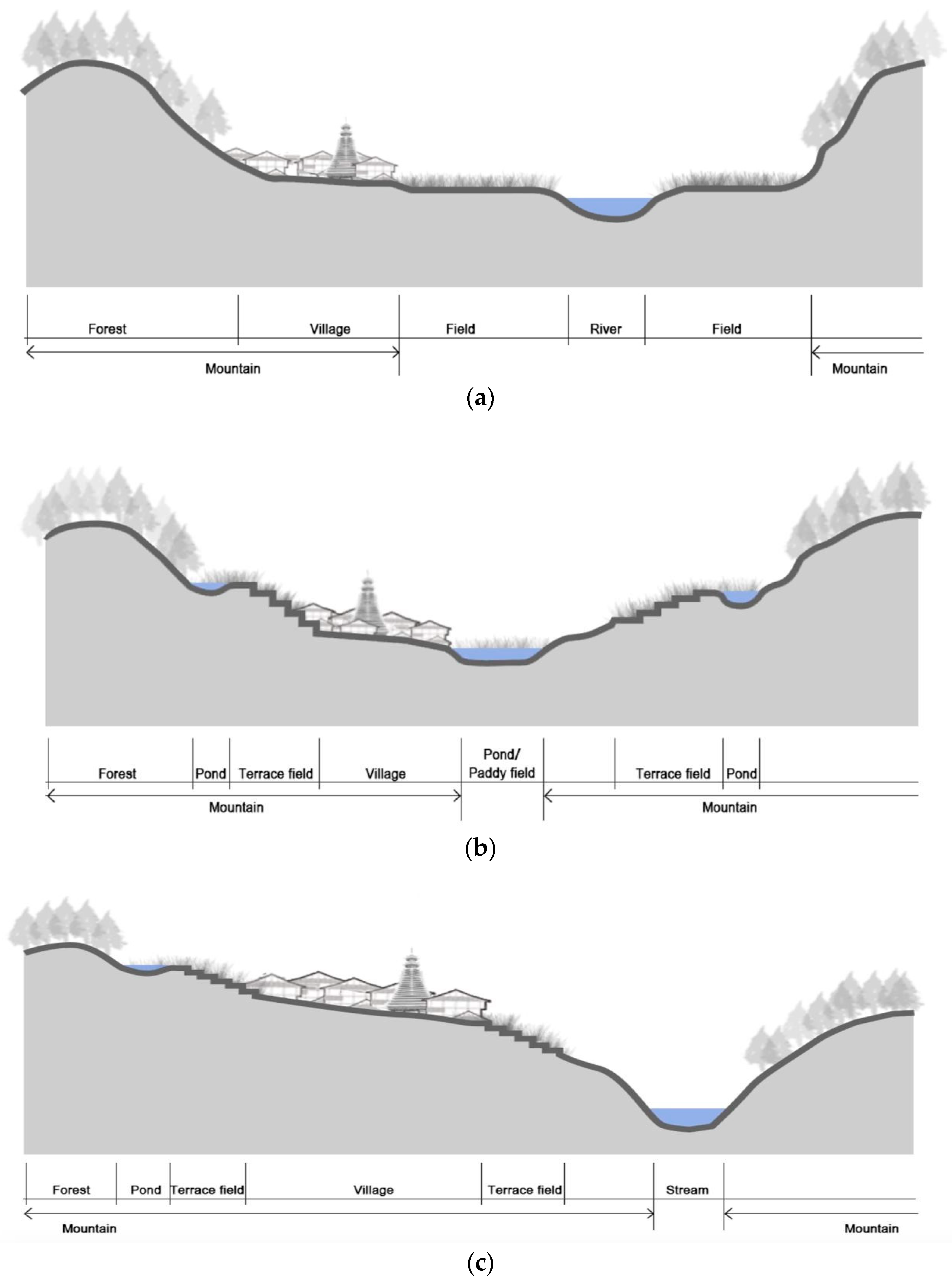
Following a series of village construction processes, the Dong village in the Nandong area generally formed a “mountain–water–field–forest–village” overall spatial pattern. Considering this pattern, the mountains surround the village and provide shelter for people; the rivers flow in the front of the village for drinking and facilitates field irrigation; the field makes full use of the valley to provide the most basic food security; the forest covers the mountains, to maintain the ecology, while protecting the village from natural disasters such as mudslides; and the village houses are built in groups, located in the river valley, or at the foot of the mountain, each with their own characteristics. The popular saying widely spread in the Dong area is that “there would be no trees without mountains, no water without trees, no water without fields, no people without fields,” which is the cultural embodiment of the overall pattern of this space.
Considering the topography and ecological conditions of the mountain valley and the mountainside slope, based on the spatial pattern and cultural tradition of “mountain–water–field–forest–village” in the “primary settled village” Dong ancestors have already formed, the water system and the sloping land were reconstructed and the “stream–ditch–pond/paddy field” system and the “terrace field” system are constructed according to local conditions; Rather than affecting the mountain forest ecosystem during the transformation, the conservation of the mountain forest was emphasized to maintain the mountain ecosystem. The village construction respected the established structure, and also paid attention to the natural shape of the mountain; Producing and living processes, in the long-term, will continuously adjust and optimize the village space pattern, and corresponding rules and regulations were established to form folk customs, which ultimately formed various spatial patterns of the settlements on targets of different hydrology and geomorphology: Regarding the settlements in basins surrounded by mountains, the mountain is densely covered with forests, the tops are arranged with ponds, and beneath the ponds are the terraces, the settlement clusters are located in the low-lying land where the mountain streams gather, inside the settlements are ponds and paddy fields to form “mountain–water–(pond)–paddy field–forest–village” spatial patterns; concerning settlements on mountainside slopes, steep terraces were built, settlement clusters located in the middle and lower parts of the terraces, water from the top of the hill flowed into the terraces and the settlement, thus forming a spatial pattern of “mountain–water–terraced field–forest–village” (
Figure 15).
Looking at the migration route of “flat river valley–mountain valley–mountainside slope”, the maintenance and coherence of the farming system of the Dong people can be seen clearly. The settlement first developed in the most suitable river valley in the paddy field. When the population expanded, the settlement began to reach into the mountain and derived the mountain rice cultivation and water arrangement methods. such as the rebuilding of the mountain stream, the construction of ponds and steep slope terraces. Finally, under the consistent overall spatial pattern, they formed characteristic patterns that were adapted to different terrain and hydrology condition. A mountain village system that adapts to the terrain and ecological environment, meeting the needs of village survival and sustainable development is established.
4.6. Leverage Effective Ecosystem Services
The organic whole space of the Dong village in the Duliujiang River Basin forms a stable and sustainable mountain ecosystem and provides a variety of effective ecosystem services, including supply services, regulatory, and cultural services.
Supply services include water supply, food production, and timber supply. The location of the village is often close to the rivers and mountains, ensuring the supply of water resources, and by building artificial water systems, so the needs of living and production can be met. Farmland and ponds can ensure the food source of the Dong people, mainly rice harvested from flat fields or terraced fields, and fish and ducks through the “rice, fish, and duck” symbiosis system. Part of the forest wood around the village can provide important resources for production and life. The Dong residents cultivate cedar trees as the main economic trees in the mountain forest and use them for the construction of villages and timber export.
Regulatory services include climate regulation, water quality regulation, runoff regulation, etc. The most prominent benefit of the Dong people’s habitat ecosystem is the hydrological regulation. Concerning the mountain environment, the construction of hierarchical fish ponds and river dams form a water system with functions such as intercepting, stocking, regulating irrigation water level and purifying water resources, to ensure the supply and use of water resources reasonably and safely.
Cultural services include providing aesthetic landscapes, regional cultural landscapes, and recreational functions. The traditional culture of the Dong people has the custom of living by the water. The Dong people who migrated to the mountainous area combined the landscape of the riverside landscape with the mountain landscape through the construction of the mountain, water, forest, and paddy field, which preserved and enriched the landscape diversity of the human settlement. The regional cultural landscape of the Dong nationality has profoundly influenced the thought and life of the Dong people. The Dong songs, which symbolize the cultural characteristics of the Dong people, often praise the majestic forests for defending villages or the rich ponds and fields. Additionally, singing together not only ensures the physical and mental well-being of the Dong people, but also enhances the cohesion of the community culture. It can be seen that the unique ecological environment makes a great contribution to the Dong community at the cultural service level.
5. Conclusions and Discussion
During the process of migration and development, the Dong people maintained the livelihood model of rice farming and transformed and utilized various hydrological and topographic environments to form unique village patterns and forms. This paper takes two pairs of typical settlements, Sizhai–Huanggang and Zhaoxing–Tang’an, with blood and regional relationships as examples. Using the anthropological “ethnographic text” and the morphological “village space information” to analyze the impact of the mountain rice livelihood model and different hydrological and topographic conditions on the spatial pattern of settlements during the historical process of the migration of the Dong people from the river valley to the mountain valley, with the focus on the sustainability of the village construction wisdom., the main findings are as follows:
First, the formation of the village group is a historical process. Under certain livelihood models, the development of the village is constantly adapted to the topography and hydrology conditions, and the newly-formed village form fully reflects the changes in the habitat. their migration path follows the characteristics of “the River Valley–the Mountain Valley-the Mountain Slope” and forms a series of primary and secondary settlements. During the migration, the Dong people’s rice production model plays the core role. Extending from the flat river valley to the mountainside valley, the topographical and hydrological environment becomes increasingly complex, so the Dong people built water systems, developed cultivated land, accumulated forest and, finally, derived from the “Mountain–Water–Forest–Paddy Field–Village” spatial pattern, the “Mountain–Water–(Pond)–Field–Forest–Village”, “Mountain–Water–Terrace–Forest–Village” settlement space patterns were formed based on local conditions.
Second, the Dong people’s settlements formed a sustainable overall space during their development and migration. The “Mountain–Water–Forest–Paddy Field” each played an important ecological role and formed an organic whole. The forest provides natural shelter for the village and conserves water resources in this overall space. Rivers, mountain streams, and ponds can be modified to supply water to fields and villages stably. Some deep paddy fields also work together with the water system, and have multiple benefits of production, water storage, and flood control.
Third, the various elements work together to form an important part of the water cycle for production and life, so the Dong people can survive and develop in different natural environments and have sustainable characteristics. Simultaneously, the local management mechanism of the Dong settlements has an important impact on its sustainable development. The Dong people’s “KuanYue” focuses on the protection and rational use of limited natural resources. Via establishing the ecological environment governance system and restricting population growth, they will construct a management and operation mechanism that fits the natural and social conditions of the Dong people to achieve the harmony between settlements and nature.
This paper focuses on the construction of settlements under a typical type of mountainous terrain, hydrological conditions, and rice farming livelihood model, forming the concept, method, and technology of ecological settlement construction, including settlement site selection, settlement space regulation, settlement spatial pattern optimization, settlement resilience, ecosystem services, etc. The indigenous knowledge of settlement construction reflects the “localized” sustainable path which is able to form a benign interaction with nature and contains significant ecological wisdom. Conversely, it contributes a valuable concept and practice case to the world’s sustainable development case database, especially to the sustainable development of mountain villages; on the other hand, the rapid urbanization and industrialization advancement have caused severe development issues of the research area. Compared with the high-consumption and high-impact development model, the region obviously should follow the path of low-impact and ecological sustainable development, and the traditional wisdom of village construction described in this study has multiple positive implications in this region.
At a broader level, this paper constructs an analytical framework for analyzing the evolution mechanism of settlements in harsh habitats, integrating multidisciplinary theories such as anthropology, spatial morphology, and human settlements science. To respond to complex habitat conditions and diverse factors during the period of evolution, the theoretical analysis framework of “habitat conditions-livelihood model-settling space” is introduced into the settlement research, and the discussion of sustainability is highly valued, which will expand the perspective, scope and theoretical framework of the field to a certain extent. This paper proposes a new method based on ethnographic texts and spatial materials to study the history of settlement construction in ethnic group areas without documented history. It also provides methodological references for some areas facing the same problems.
Naturally, there are many important issues for the sustainable development of the region that need to be studied. How can the traditional livelihood model be passed down and renovated in villages affected by urbanization and industrialization? How will villagers choose the right path for economic development in the contemporary era? How to coordinate the multi-factors such as villagers’ income increase, tourism development, multiculturalism maintenance, and ecological environment protection? These issues are particularly important and urgent at the moment.


