Revising Yield and Equivalence Factors of Ecological Footprints Based on Land-Use Conversion


1
School of Ecology and Environmental Sciences, Yunnan University, Kunming 650091, China
2
School of Agriculture Economics and Rural Development, Renmin University of China, Beijing 100872, China
*
Author to whom correspondence should be addressed.
Sustainability 2018, 10(11), 4107; https://doi.org/10.3390/su10114107
Submission received: 18 October 2018
/
Revised: 4 November 2018
/
Accepted: 6 November 2018
/
Published: 8 November 2018
(This article belongs to the Special Issue Agriculture, Landscape, Ecosystem Services and Biodiversity: New Challenges for Sustainable Development)
Abstract
:In the current ecological footprint (EF) calculations, the parameters of built-up land are set as equal to those of cropland, based on the assumption that built-up land is totally converted from cropland. However, built-up land may be derived from other types of land use. With the expansion of built-up area as a result of urbanization, the yield and equivalence factors of built-up land are becoming increasingly important in the EF calculation. The objective of this study was to evaluate the influence of this assumption on EF calculation. In this study, the proportions of different land types converted into built-up land were evaluated based on actual land-use conversion in two urbanized areas of Yunnan Province and Kunming City from 1980 to 2010 in the ArcGIS platform. Then, the parameters of built-up land were calculated by an area-weighting approach with the proportions. The results showed the following: (1) In both cases, the EF of Yunnan Province and Kunming City were greater than their biocapacities (BC), indicating that they were in unsustainable states. (2) The EF and BC of the two studied cases were reduced to varying degrees because the yield and equivalence factors of built-up land from land-use conversion are less than cropland factors. As the proportion of the built-up land area in Kunming City was larger than that in Yunnan Province, the reduced proportion of the EF and BC of Kunming City is greater than that of Yunnan Province. (3) The proportion of built-up land converted from cropland has a significantly positive correlation with EF and BC. Therefore, it is of great significance to revise the yield and equivalence factors of built-up land using actual land-use conversions in highly urbanized areas.
1. Introduction
With the continuous expansion of the global population and resource consumption, pollution and other human activities are increasingly close to their environmental capacity, and are exceeding it in some regions, which seriously degrades human sustainability [1]. Since 1987, sustainability has become the development strategy of countries all over the world [2]. Quantifying sustainability and transforming it into an operational model is vital for management [3]. Therefore, many international organizations and related researchers have explored methods and indicators to quantify sustainability, such as the National Wealth Indicator System [4], Sustainable Economic Welfare Index [5], and Barometer Sustainability [6]. However, evaluation methods based on these index systems focus on the assessments of social economic development status, and there is still a large degree of subjectivity and uncertainty in the selection of evaluation indicators, weight determination, and index calculation methods. How to quantify sustainability has long been a difficult problem in sustainable development research. William Rees proposed the ecological footprint (EF) concept, which quantifies sustainability through two normalized indicators to determine human survival within the scope of ecosystem capacity [7]. The EF has been demonstrated to be a good approach for measuring ecological impact and capacity [8,9,10].
The EF is primarily used to calculate the bioproductive land of a region that is necessary for the maintenance of resource consumption and the absorption of generated waste by human activities [11]. The EF determines (1) the area of cropland, pasture, forest, and fishing ground used for the production of agriculture, livestock, forest, and fishery, respectively, that are consumed by humans, and (2) the forest area for absorbing carbon released by burning fossil fuels [12]. The EF is compared with the area’s available biocapacity (BC). By comparing the EF and BC, it can be determined whether a region is sustainable. When the EF is larger than the BC, it is considered to be an “ecological deficit”, indicating that human beings are in an unsustainable state. By contrast, if the EF is smaller than the BC, humans are considered to be in a sustainable state [1,13,14,15,16]. To quantitatively research the regenerative capacity needed to maintain a given resource stream, the calculation of the EF is based on some assumptions [17]. These assumptions are also a prerequisite to the wide application of the EF approach. However, there are many controversies surrounding these assumptions that result in uncertainties being brought into the calculations, and these assumptions are worthy of further assessment [12,18,19,20,21]. In the process of an EF calculation, it is assumed that the built-up land is all converted from cropland, so the yield and equivalence factors of cropland are adopted for the built-up land. However, in reality, built-up land can be transformed from other types of land such as forest, pasture, and fishing ground. Since the yield and equivalence factors vary substantially among different land uses, and the factors of cropland usually rank the highest, the assumption may overestimate the EF and BC of built-up land. How does built-up land impact the EF and BC? At different research scales, is there any difference in this kind of impact? The answers to these questions are still largely unknown. Therefore, the aim of this study was to assess the impact of this hypothesis in order to improve the accounting method for calculating the EF and BC.
Based on the integrity and accessibility of data, we chose Yunnan Province and Kunming City—which have different research scales and various built-up land percentages—as the case studies, and calculated their EF and BC in 2010. Using historical land-use data, a land-use conversion matrix was established to calculate the sources of built-up land from 1980 to 2010 through the ArcGIS platform. Then, the yield and equivalence factors of the built-up land were calculated from those factors based on the proportion of its sources. Comparing the revised and unrevised EF and BC, the changes in the EF and BC under different built-up land factors were analyzed, and the impact of the assumptions for EF and BC calculations were explored. Furthermore, the impact of the assumptions was explored under different spatial scales by comparing the changes in Yunnan Province and Kunming City.
2. Materials and Methods
2.1. Study Area
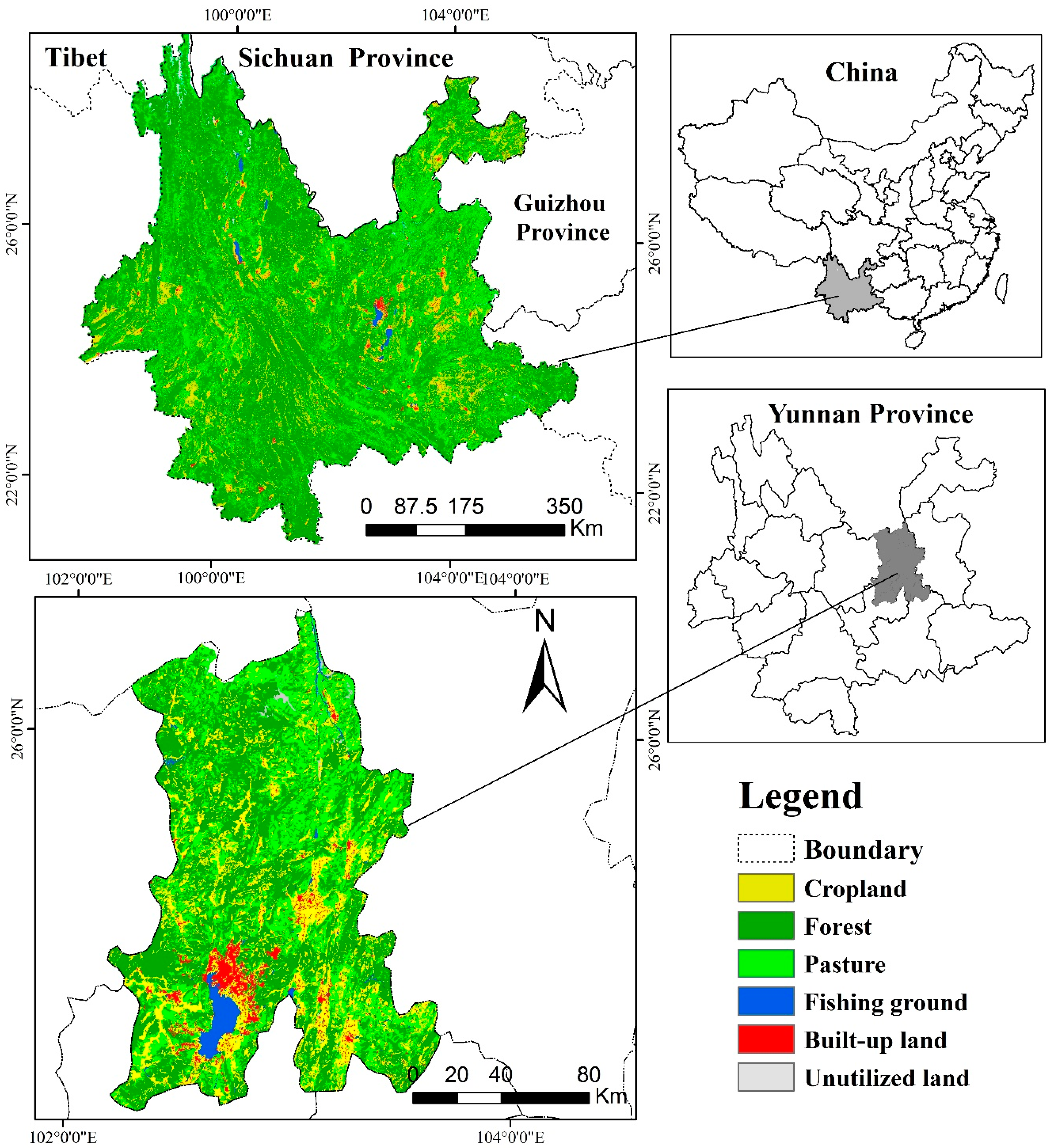
Yunnan Province is located at 21°8′–29°15′ N and 97°31′–106°11′ E in southwestern China, and Kunming is the capital of Yunnan Province, located at 102°10′–103°40′ E and 24°23′–26°22′ N. In 2010, the area of Yunnan Province was 3.83 × 10⁵ km2, with a population of 46.01 million, of which, the urban population accounted for 35.20%, and the rural population accounted for 64.80%. The area of Kunming was 2.15 × 10⁴ km2, with a population of 6.36 million, of which the urban population accounted for 64.00%, and the rural population accounted for 36.00%. Forest, cropland, and pasture are the dominant land areas in Yunnan Province (Figure 1). From 1980 to 2010, the area of cropland, pasture, unutilized land, and fishing ground in Yunnan Province decreased, while forest and built-up land areas increased continuously. However, the built-up land in Kunming increased significantly, which was mainly due to its rapid urbanization [22].
Yunnan Province plays an important role in maintaining global biodiversity and provides a natural defense for southwestern China [23]. As urbanization accelerated in this region, most of its cropland has gradually been converted into built-up land, followed by a large area of forest and pasture that converted to cropland [22]. Yunnan Province acts as a good case for studying the relationship between environmental change and human impacts.
2.2. Methods
2.2.1. The EF Model
The EF was developed by William Rees in 1992, and perfected by Wackernagel in 1996, to measure the human use of natural resources and the functions of natural support service for human. It measures the sustainability of a region by estimating the amount of mutually exclusively bioproductive area required to sustain human natural resource consumption and assimilate human-generated waste, and comparing it with the biocapacity of this region [7,8,9,10].
The EF model is used to calculate the area of bioproductive land that is necessary to sustain human resource consumption and waste absorption in the region. In the EF model, human resources and energy consumption items are expressed as 5 kinds of bioproductive lands: cropland, pasture, forest, built-up land, and fossil fuel land. Since the bioproductivity varies between different land-use types and between different regions, the EF is expressed in terms of the world average bioproduction area (i.e., global hectares (gha)), calculated by multiplying the yield and equivalence factors. In this way, comparisons can be made between different regions and land uses [16]. The EF can be calculated as follows:
where i is the set of six land-use types; N is the total population; Ci is per capita consumption of i; Pi is the total consumption of i; Yni is the yield of i in the region; Ywi is the average yield of i in the world; YFi is the yield factor of i; EQFi is the equivalence factor of i; EFb is the EF of biological resources; EFc is the EF of fossil fuel-carbon; and EFp is the EF of built-up land.
The yield factors (YFs) are the ratios of the yield of the bioproductive areas in a region (or a country) to the global average yield of the same species. They show the differences in biological productivity between regions, and might reflect natural situations, such as temperature or precipitation, as well as anthropogenic management levels [13,24]. The yield factors can be estimated from the actual agricultural production or the net primary productivity (NPP) [19,25,26,27]. In this study, we used the ratios of Yunnan’s NPP to the global average NPP to represent the yield factors of different bioproductive areas in Yunnan Province. The NPP of different bioproductive areas in Yunnan were derived from Liu and Li [28], and the resulting yield factors were 1.62, 1.13, 1.50, and 2.18 for the cropland, forest, pasture, and fishing ground, respectively.
The equivalence factors (EQFs) represent the global average potential productivity for a given bioproductive area relative to the average potential productivity of all global production areas. Since the potential productivity of different bioproductive areas is different [24,25], it is necessary to multiply the equivalence factors to transform them into global hectares for the convenience of comparison. Similar to the yield factors, the equivalence factors can be estimated from the NPP or emergy [29]. The potential productivity of different bioproductive areas was not the focus of this study, so we chose the results of World Wildlife Fund (WWF) in 2002 [30]. The equivalence factor of the cropland, forest, pasture, and fishing ground were 2.19, 1.38, 0.48, and 0.36, respectively. Following other studies, the equivalence factor of fossil fuels in this paper was the same as that of forest [24,26,31]. The equivalence factor of built-up land is usually set the same as cropland land under the assumption that built-up land is totally derived from cropland. In this study, an area-weighted equivalence factor based on the actual sources of built-up land was used by calculating the land-use conversion from 1980 to 2010 to the built-up land in the cases studied.
The EF of Biological Resources
Cropland, forest, pasture, and fishing ground provide biorenewable resources for human economy and society. The footprint of each land use is the sum of all the consumed products within the category. Table 1 shows the contents of the products included in each category. The average global yield of each product comes from the study of Wackernagel et al. [31]. The formula for the EF of each biological area is as follows:
where i is the kind of bioproductive area; Qcap is the population; Cper cap is the consumption of per person; and Yga is the global average yield of the bioproductive area.
The EF of Fossil Fuel-Carbon
As a result of fossil fuel combustion, greenhouse gases (mainly carbon dioxide, CO2) have posed a great threat to global sustainability, and have been considered to be important to the EF. The CO2 footprint estimates the additional bioproductive area that can absorb CO2. Since CO2 is mainly absorbed by forests in terrestrial ecosystems, fossil energy lands are treated as forests. In addition, the oceans are able to absorb carbon dioxide and contribute a significant percent of their absorption. It has been reported that a quarter of the total anthropogenic emissions should be deducted from the calculation [32]. The formula for the EF of fossil fuels (EFc) can be presented as follows:
where Pc is the total CO2 of anthropogenic emissions; Socean is the proportion of CO2 absorbed by oceans (1/4); Yc is 1.42 t/ha, which is the global average rate of CO2 absorbed per hectare of forest [33]; EQFf is the equivalence factor of the forest; Pbc is the carbon dioxide emitted from burning coal; Poc is the carbon dioxide emitted from burning oil; and Png is the carbon dioxide emitted from burning natural gas.
According to the United States Oak Ridge National Laboratory [34], the carbon dioxide generated from burning coal could be calculated as follows:
where Mc is the standard coal equivalent of burning coal; EOF is the effective oxidation fraction (EOF = 0.98); and Cpc is the carbon content of per ton of standard coal (Cpc = 0.73).
where Mo is the standard coal equivalent of oil consumption.
where Mng is the standard coal equivalent of natural gas.
In Yunnan Province, there is no nuclear power station and little biomass substitution, so they are not included here.
The EF of Built-Up Land
In reality, built-up land may be derived from the other four types of land uses, so the YF and EQF of the built-up land should be equal to the area-weighted YFs and EQFs of the land uses the built-up land replaces, rather than cropland alone. According to the land uses in 1980 and 2010, the weight coefficient of the area can be obtained through the transfer matrix analyses in the ArcGIS platform. In this study, the EQF and YF of the built-up land were calculated from the perspective of the actual land-use conversion. Thus, the EF of built-up land can be presented as follows:
where Ap is the area of built-up land; EQFp is the equivalence factor of built-up land; and YFp is the yield factor of built-up land.
where Rf is the area ratio of forest to built-up land; Ef is the equivalence factor of forest; Rp is the area ratio of pasture to built-up land; Ep is the equivalence factor of pasture; Rc is the area ratio of cropland to built-up land; Ec is the equivalence factor of cropland; Rw is the area ratio of fishing ground to built-up land; and Ew is the equivalence factor of fishing ground.
where Rf is the area ratio of forest to built-up land; Yf is the yield factor of forest; Rp is the area ratio of pasture to built-up land; Yp is the yield factor of pasture; Rc is the area ratio of cropland to built-up land; Yc is the yield factor of cropland; Rw is the area ratio of fishing ground to built-up land; and Yw is the yield factor of fishing ground.
2.2.2. Calculation of the BC
The BC is the counterpart of the EF, indicating the strength of the carrying capacity for a region. A nation’s BC is the sum of all its bioproductive areas and is usually described in global hectares. Each bioproductive area was transformed into global hectares by multiplying its EQF and YF.
where i is the set of five land-use types; Ai is the area of i; EQFi is the equivalence factor of i; and YFi is the yield factor of i.
2.2.3. Calculation of the ED
The relative magnitudes of EF and BC reveal whether existing natural resources are sufficient to support social development and human consumption. If the BC is larger than the EF, then there is ecological reserve (ER). If the EF is larger than the BC, then there is ecological deficit (ED), indicating a mismatch occurring locally in the region [35].
2.3. Data Sources
Yunnan Province and its capital, Kunming City, were selected as the two cases studied in this study, considering their varying urbanization levels. The basic socioeconomic data (population, GDP, PGDP, energy resource consumption, commerce) used in this study were derived from the Statistical Yearbook of Yunnan Province in 2011, and the County’s Statistical Yearbook of Yunnan Province in 2011. The data of production and consumption of biological resources used in this study were derived from the China Urban Statistical Yearbook 2011 and the China Rural Statistical Yearbook 2011.
The land-use data was obtained from Geographical Information Monitoring Cloud Platform (http://www.dsac.cn/DataProduct/Detail/200804), with a spatial resolution of 30 m, and the data were acquired in 1980 and 2010, respectively. In this study, land-use types were divided into six categories, and the classification methods referred to China National Current Land-Use Classification Standard (GB/T 21010-2017) [36]. The specific classification which was used in this study has been published in many studies [37,38,39]. The land-use conversion data were obtained in the ArcGIS platform. The method was used in some publications [40,41,42]. In the ArcGIS platform, firstly, the land-use data of 1980 and 2010 were merged (the “Dissolve” function); secondly, layer overlay analyses were performed (the “Intersect” function); thirdly, a new attribute list (the “Calculate Geometry” function) was established; and, fourthly, matrix analyses were performed for the obtained data through Excel2016. Finally, the land-use conversion data were obtained from 1980 to 2010.
3. Results and Discussion
3.1. The Factors of Built-Up Land
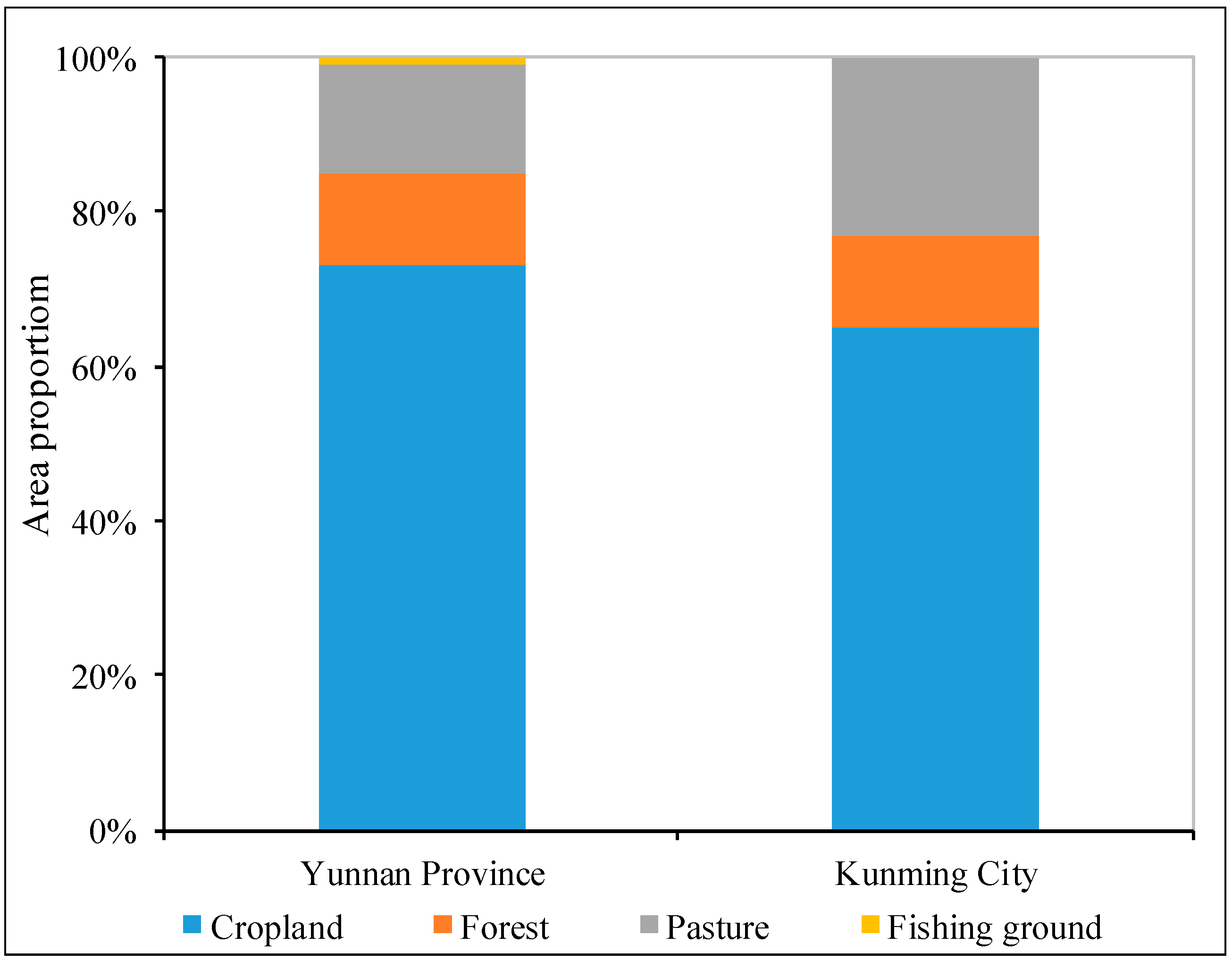
The land-use conversion data were obtained through the matrix analyses transfer of the land use between 1980 and 2010. The built-up land area of Yunnan Province was 1732.61 km2 in 1980, and increased to 3083.98 km2 in 2010. The area of built-up land increased by 1351.36 km2 in 30 years. The area converted from cropland to built-up land was 1103.68 km2, which accounted for 73.05% of the total conversion area. The changes are shown in Figure 2. Therefore, cropland was the main source of converted lands for the built-up area. This result has some similarities with the assumption of the built-up land footprint. However, it is obvious that other land uses also contributed significantly. The area converted from forest to built-up land was 179.29 km2, which accounted for 11.88% of the area converted. The area converted from pasture to built-up land was 211.36 km2, making up 14.20% of the total converted area, and the area converted from fishing ground to built-up land was 12.86 km2, which made up the remaining converted area. These parts of the total conversion area accounted for 26.95% of the total area converted, which is different from the assumption of the construction land footprint (Figure 3).
The results of the land-use transformation matrix in Kunming City from 1980 to 2010 were different from those in Yunnan Province. The area of built-up land increased by 293.62 km2 in 30 years. The area had a total conversion area of 64.95% that was converted from cropland to built-up land. The total area converted from forest to built-up land was 12.11%. The area that was converted from pasture to built-up land was 22.94%. The changes were shown in Figure 3. The cropland was the main source of converted lands for built-up areas, but the other land uses clearly contributed. The proportion of built-up land originating from cropland in Yunnan Province was larger than that in Kunming City. This difference was relative to the level of economic development, urbanization rate, land-use policies, and so forth [43,44,45,46,47]. In 2010, the urbanization rate of Yunnan Province was 35.20%, and the per capita GDP was 15,752 RMB. The urbanization rate of Kunming City was 64.00%, and the per capita GDP was 33,549 RMB. As of 31 December 2010, there were total 93 laws and regulations, related to land transfer, management, and land-use planning, had been shown on the official website of Kunming Municipal Bureau and Yunnan Provincial Department of Land and Resources. This factor was one of the main reasons that led to the difference in the land-use change.
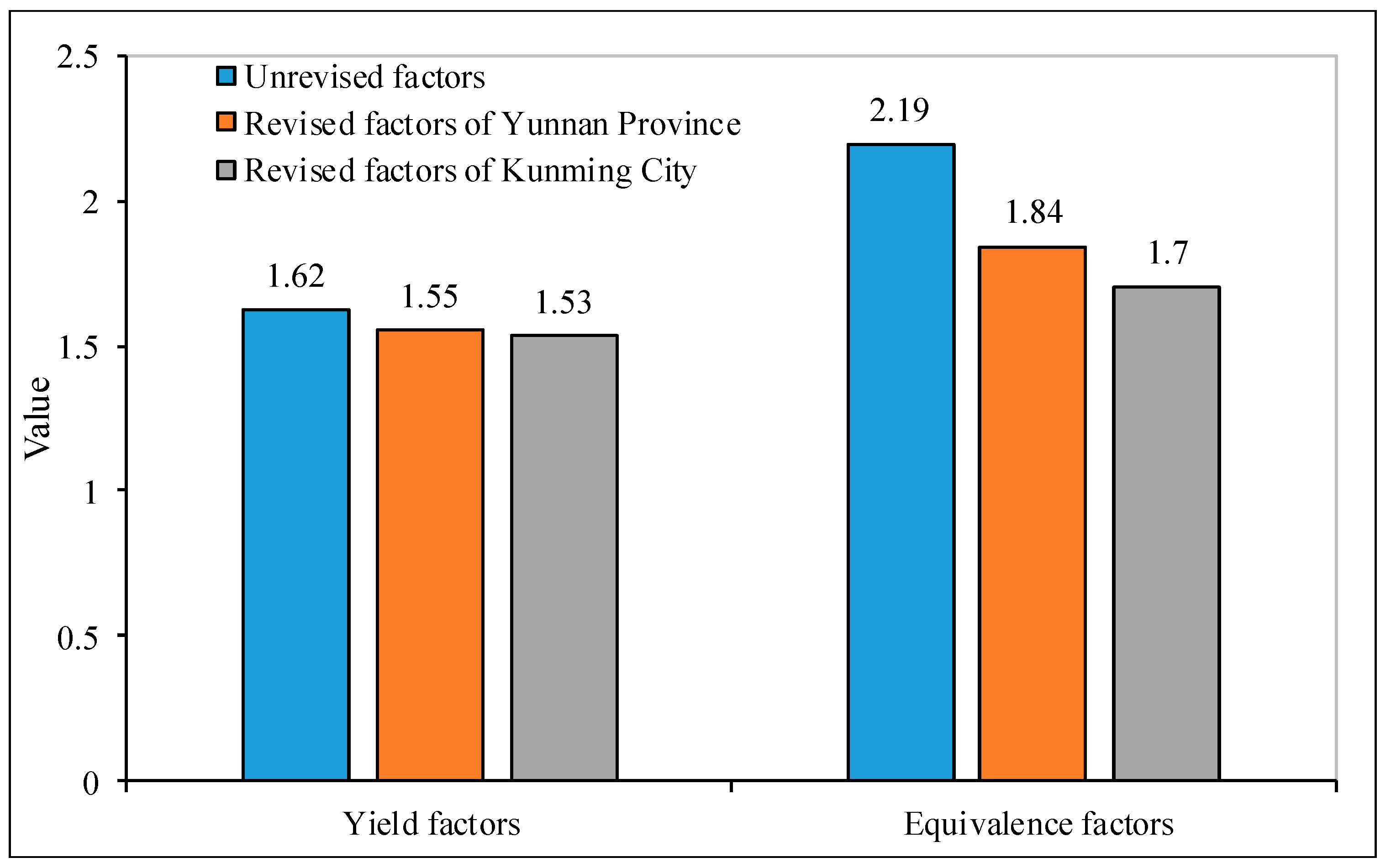
According to the results of the land-use conversion matrix and the yield factors of the four kinds of land use, the yield factors of built-up land were weighted according to the conversion ratio. The revised yield and equivalence factors of built-up land in Yunnan Province were 1.55 and 1.84, respectively (Figure 4). The revised yield and equivalence factors of built-up land in Kunming City were 1.53 and 1.70, respectively. It is obvious that there are some differences in the yield and equivalence factors under different research scales. In general, the revised yield and equivalence factors were smaller than those without the revision.
3.2. Case Study: Yunnan Province
3.2.1. Estimating EF
According to the classified catalog in Table 1, we obtained the EF of cropland, forest, pasture, and fishing ground as 26.99 million gha, 20.09 million gha, 4.58 million gha, and 1.14 million gha, respectively. Based on the Statistical Yearbook of Yunnan Province in 2011 and the Statistical Yearbook of China in 2011, the fossil energy consumption in Yunnan Province is shown in Table 2. The total fossil energy consumption was 62.80 million tons of standard coal, and the area of fossil energy land obtained through the carbon dioxide footprint calculation formula was 34.13 million gha.
Based on the EF of built-up land formula, we obtained the EF of built-up land as 0.88 million gha with revised factors, and the EF of built-up land was 1.08 million gha with unrevised factors. Hence, a 19.61% reduction in the EF of built-up land was seen with the use of revised factors.
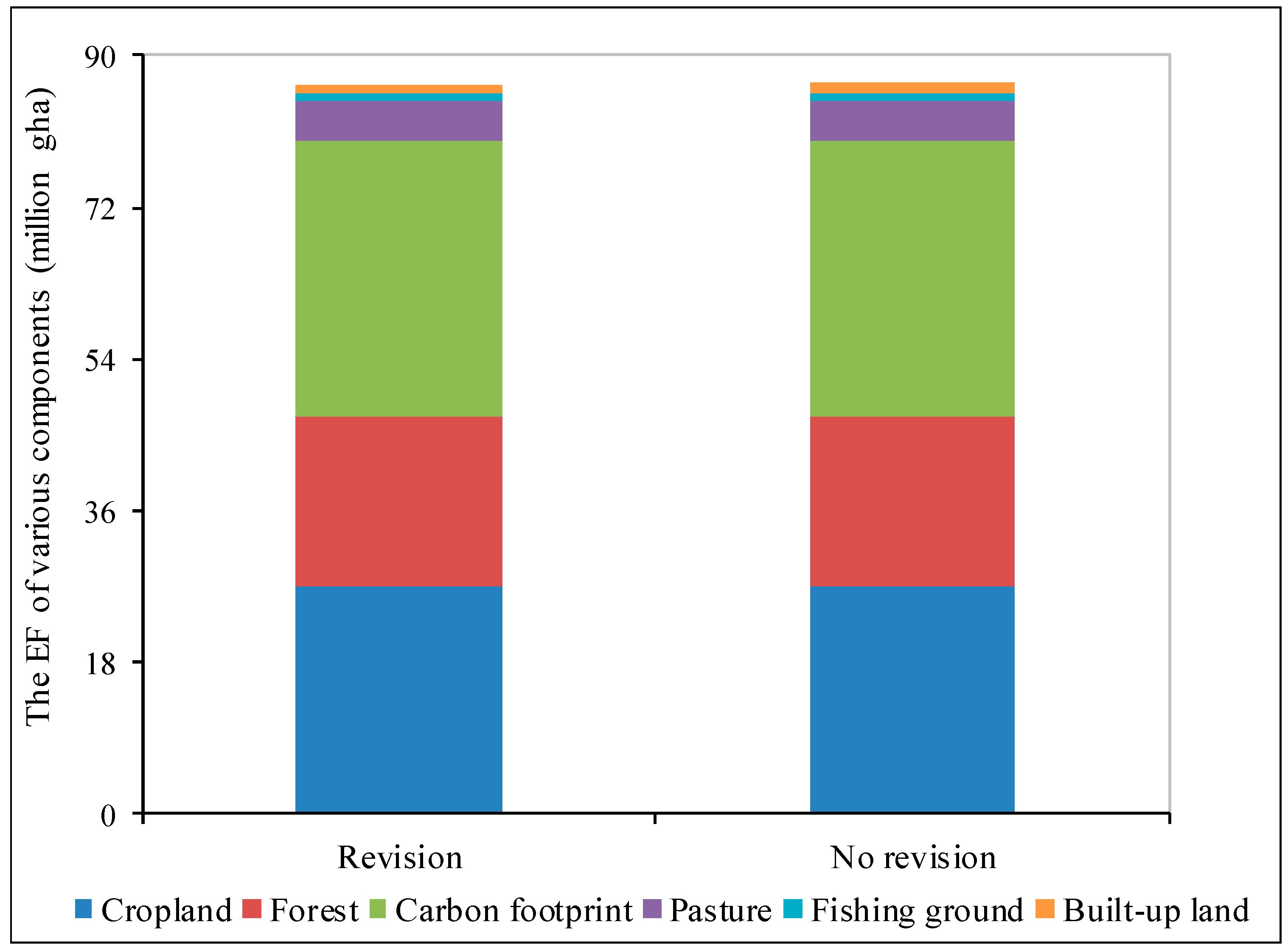
The EF of Yunnan Province is shown in Figure 5. With the revised factors, the EF of Yunnan Province was 88.03 million gha. Cropland, forest, fossil fuel-carbon, pasture, fishing ground, and built-up land accounted for 30.74%, 22.88%, 38.87%, 5.22%, 1.30%, and 1.00%, respectively, of the EF. This phenomenon is similar to the EF of China from 1978 to 2010 [43]. Since China is an agricultural country, its agricultural production and consumption are higher than those of other products. However, the EF of fossil fuel-carbon has become the largest component in the consumption footprint since 2005, which increased to 35% in 2010. The similar proportion of fossil fuel-carbon indicates that the fossil fuel consumption of Yunnan Province has reached the average of China. The difference is that the proportion of pasture land in Yunnan Province is less than that in China, because the production and consumption of pasture land in Yunnan Province is scarce. Based on these proportions, the EF proportions of cropland, forest, and fossil fuel-carbon were the main components as they accounted for 92.48% of the EF. This result showed that the consumption of resources and energy was the main source of the EF. However, the ratio of fossil fuel-carbon was the largest, which indicated that economic development depended on fossil fuel and the energy consumption accounted for a large proportion of economic growth. Compared with the research of the Ecological Footprint Dynamics of Yunnan, in this study, the proportion of fossil energy land in the total EF increased continuously from 1988 to 2006. Specifically after 2000, the growth rate was obvious and, in 2006, the EF of fossil energy land accounted for 35% of the total EF in Yunnan Province [48]. Therefore, energy is likely to be the main factor restricting the sustainability of Yunnan Province in terms of social development. This phenomenon is similar to those in past publications [29,49,50,51,52]. With the unrevised factors, the EF of Yunnan Province was 87.82 million gha. Among them, the EF of cropland, forest, fossil fuel-carbon, pasture, fishing ground, and built-up land separately accounted for 30.66%, 22.82%, 38.77%, 5.20%, 1.30%, and 1.24%, respectively. The proportion was similar to that with the revision, but the proportion of built-up land is slightly increased. From the results, we can determine that the revised EF of Yunnan Province was 0.22 million gha less than that without the revision, which made up the unrevised EF of 0.23%. The revised EF per capita was 0.01 gha less than that without the revision. This result indicates that the revised factors lead to a reduction in the EF, but the reduction is small in proportion to the total amount, especially to the average person, with little influence.
3.2.2. Estimating BC
The results of the BC calculations are shown in Table 3. With the revised factors, the BC of built-up land was 0.88 million gha, and the total BC was 66.02 million gha. Cropland, forest, pasture, fishing ground, and built-up land accounted for 36.84%, 52.03%, 9.45%, 0.34%, and 1.33% of the BC, respectively. The largest proportion was forest, indicating that the forest provided abundant forest products and absorbed much of the waste gases in Yunnan Province. With the unrevised factors, the BC of built-up land was 1.09 million gha, and the total BC was 66.24 million gha. Compared with the BC of built-up land, the revised BC was 0.22 million gha less than that without the revision, which accounted for 19.61% of the unrevised BC of built-up land. The total BC was 0.22 million gha less than that without the revision, which accounted for 0.32% of the unrevised BC. The BC per capita was 0.01 gha less than that without the revision. The results showed that the revised factors had a great influence on the BC of built-up land, a small influence on the total BC and little effect on the per capita BC. The result is similar to the influence of the revised factors on the EF.
According to the ED formula, we obtained a total ED of 21.80 million gha, and the revisions have no effect on the ED, which is 0.48 gha per capita. Since the EF and BC both decreased, and the decreased amount was identical after the revised factors, the revised factors had no effect on the ED. The ED of Yunnan Province was larger than that in this study [48]. The reason for this result is that we used different yield and equivalence factors.
3.3. Case Study: Kunming City
3.3.1. Estimating EF
In 2010, the population of Kunming City was 6.39 million people, of which the rural population was 2.32 million, and the urban population was 4.07 million. On the basis of the Statistical Yearbook of Kunming City in 2011, the Yunnan Province Statistical Yearbook in 2011, and survey data, the consumption of various types of biological products were obtained through calculation. The EF of cropland was 2.68 million gha, the EF of forest was 1.67 million gha, the EF of pasture was 2.31 million gha, and the EF of fishing ground was 4.28 million gha. The total fossil energy consumption was 17.72 million tons of standard coal, and the area of fossil energy land obtained through the carbon dioxide footprint calculation formula was 10.44 million gha. The EF calculation method of built-up land was consistent with the provincial level. The unrevised EF of built-up land was 0.24 million gha, and the revised EF of built-up land was 0.18 million gha—a 26.55% reduction in the EF of built-up land using revised factors.
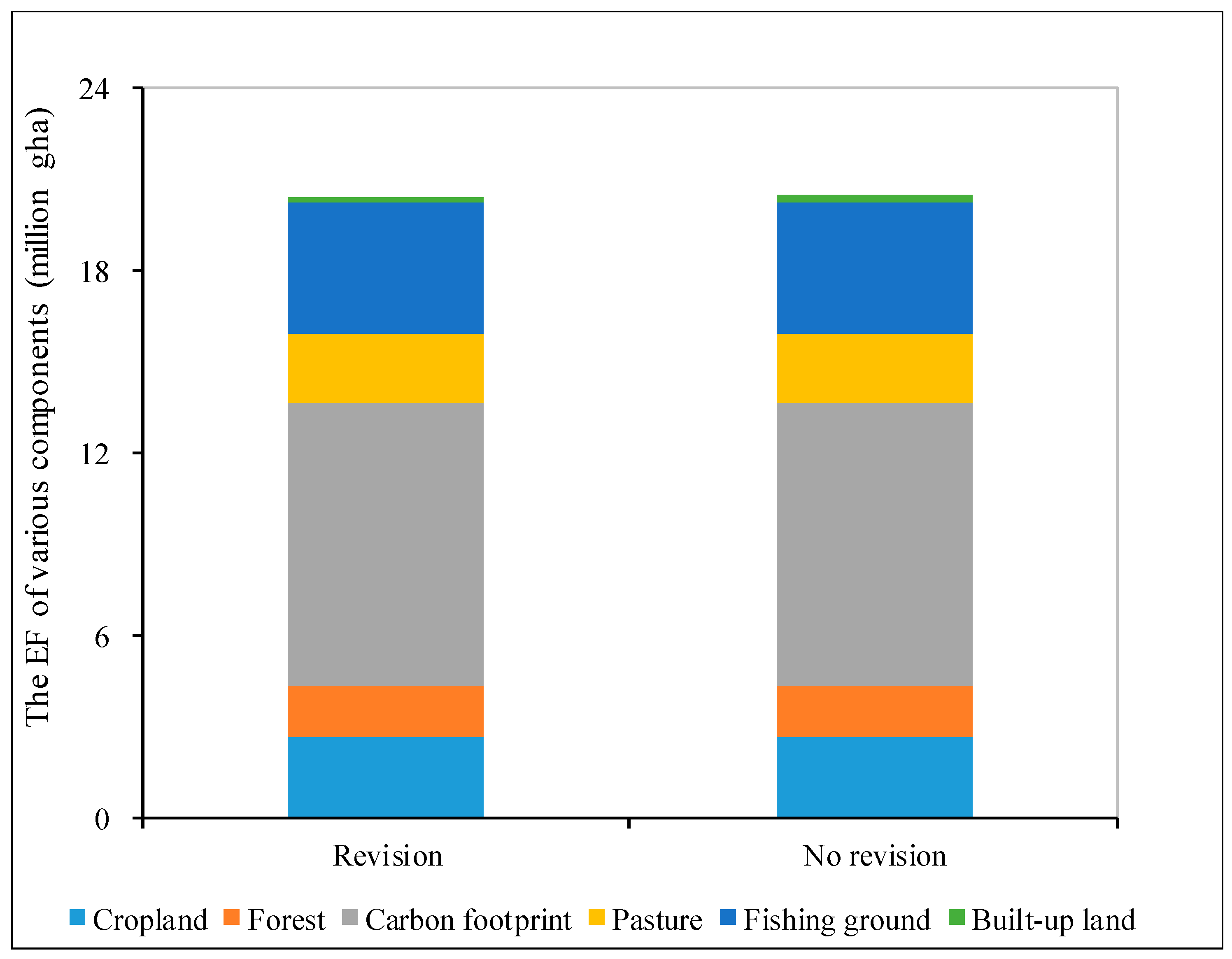
The EF of Kunming City is shown in Figure 6. The revised EF was 21.56 million gha. The cropland, forest, fossil fuel-carbon, pasture, fishing ground, and built-up land accounted for 12.43%, 7.75%, 48.43%, 10.70%, 19.86%, and 0.83%, respectively, of the EF. Based on these proportions, the ratio of fossil fuel-carbon was the largest, which was similar to that of Yunnan Province, but the proportion of fossil fuel-carbon was much higher than that of Yunnan Province. This result shows that the economic development of Kunming City relied more on fossil energy than that of Yunnan Province. The proportion of fishing ground was very high, and was larger than that of Yunnan Province. This result is strongly related to Kunming’s industrial structure. In 2010, the proportion of tertiary industry in Kunming City accounted for 49.01% of GDP, larger than that in Yunnan Province, which accounts for 40.04% of GDP. In the tertiary industries, tourism provided the largest contribution. This led to the proportion of fishing ground of EF in Kunming City being larger than that in Yunnan Province. Factors, such as urbanization levels and per capita GDP, also contribute to these differences. The unrevised EF was 21.62 million gha, and the proportions of the various components were similar to those that were revised. Therefore, the total EF was reduced by 64,830 gha, which was 0.28% of the unrevised EF. The EF per capita was reduced by 0.01 gha, which was minimally changed.
3.3.2. Estimating BC
With the revised factors, the BC of built-up land was 0.18 million gha, and the total BC was 3.64 million gha. Cropland, forest, pasture, fishing ground, and built-up land accounted for 40.44%, 40.34%, 11.60%, 1.03%, and 6.59% of the BC, respectively. The largest proportions were cropland and forest, indicating that cropland resource was a primary element of the local biocapacity. Compared with Wuhan City, the largest proportion of the biocapacity was cropland, which exceeded 80%, and the proportions of forest and pasture were lower than 5% [35]. This indicated that the biocapacity of forest and pasture in Kunming City had a larger contribution to the total biocapacity than that in Wuhan City. This phenomenon is the same as the development goals of two cities in China. The main goal of Wuhan is to develop heavy industry. For Kunming, the main goal of future urban development is to develop tourism based on the protection of the environment. With the unrevised factors, the BC of built-up land was 0.24 million gha, and the total BC was 3.70 million gha. Compared with the BC of built-up land, the BC was reduced by 64.8 thousand gha, which accounted for the BC of built-up land with an assumption of 26.55%. Compared with the total BC, the BC was reduced by 64,800 gha, which accounted for the BC with an assumption of 1.75%. The BC per capita with this assumption is 0.57 gha, and this value was the same as the BC per capita with the matrix analyses transfer of land use.
According to the ED formula, we obtained the total ED of Kunming City of 17.92 million gha, and the revisions had no effect on the ED which was 2.60 gha per capita. The ED change was zero, but it was 5.78 times greater than the per capita EF of Yunnan Province. This result was consistent with the GDP per capita.
3.4. The Impact of Revised Built-Up Land Factors on the EF and BC Assessment
3.4.1. The Effects of Revisions on Different Research Scales
Comparing the results of EF in Yunnan Province and Kunming City, we found that the effects of revisions on different research scales were different. In 2010, the EF of Yunnan Province was 88.03 million gha without revisions, while it was 87.82 million gha with revisions. The revised assessment of Yunnan Province’s EF was reduced by 0.2 million gha, which accounted for 0.23% of the uncorrected EF. Analyzing the components of EF, it was found that the correction only affected the EF of built-up land, but did not affect the other components. In Figure 4, the EF of the built-up land accounted for 1.24% of the total EF, which is negligible. Therefore, the impact of corrections on the structure of EF is insignificant. The EF of built-up land was 1.08 million gha without revisions, while it was 0.88 million gha with revisions. The reduction was 0.2 million gha, which accounted for 18.51% of the uncorrected EF. It was equivalent to about a fifth of the built-up land being neglected. Such a large proportion made it impossible to ignore in the calculation. The reason for the reduction was that the yield and equivalence factors of built-up land, with revisions, were smaller than that without revisions. In 2010, the EF of Kunming City was 21.62 million gha without revisions, and it was 21.56 million gha with revisions. The reduction was 0.06 million gha, which accounted for 0.28% of the unrevised EF. As in the case of Yunnan Province, the correction only affected the EF of built-up land, and barely affected the structure of EF. The EF of the built-up land was 0.24 million gha without revisions, and it was 0.18 million gha with revisions. The reduction was 0.06 million gha, which accounted for 25% of the uncorrected EF. It was equivalent to about a quarter of the built-up land not counted in the calculation of EF.
The value and proportion of the reduction for Yunnan Province and Kunming City were different. From the perspective of value, the reduction of total and built-up land EF in Yunnan Province was greater than that in Kunming City. However, from the perspective of proportion, the reduction of total and built-up land EF in Kunming City was larger than that in Yunnan Province. This phenomenon indicates that the impact of revisions on the calculation of EF were related to the research scales. To further explore the relationship, we analyzed the land-use composition of the two cases. The proportion of built-up land area to the total area was 3.28% in Kunming City, and that was 0.8% in Yunnan Province. Therefore, the larger the proportion of built-up area, the larger the accuracy of EF calculation with revisions.
3.4.2. The Effects of Revisions on Different Research Subjects
In the results, the effects of revisions on EF, BC, and ED were different. In 2010, the ED in Yunnan Province was 20.6 million gha, and it was 16.8 million gha in Kunming City. In consequence, the revisions had no impact on the calculation of ED. The BC was 66.24 million gha without revisions, and it was 66.02 million gha with revisions in Yunnan Province. The reduction was 0.22 million gha, which accounted for 0.32% of the uncorrected BC. Similar to the analysis results of EF, the revisions only affected the BC of built-up land, and barely affected the structure of BC. The BC of built-up land was 1.09 million gha without revisions, and it was 0.88 million gha with revision. The reduction was 0.22 million gha, which accounted for 19.61% of the unrevised EF of built-up land. The proportion was equivalent to about one-fifth of built-up land not calculated in the calculation of BC. The BC was 3.70 million gha without revisions, and it was 3.64 million gha with revisions in Kunming City. The reduction was 0.06 million gha, which accounted for 1.75% of the uncorrected BC. The BC of built-up land was 0.24 million gha without revisions, and it was 0.18 million gha with revision. The reduction was 0.06 million gha, which accounted for 26.55% of the unrevised EF of built-up land. The proportion was equivalent to about one-quarter of built-up land not calculated in the calculation of BC.
Compared with the results in the previous section, the revisions made EF and BC decrease, but the extents of reduction were different. From the perspective of total volume, it was found that the reduction ratio of EF was larger than that of BC in both Kunming City and Yunnan Province. From the perspective of built-up land, whether it was in Kunming City or Yunnan Province, the reduction ratio of EF was larger than that of BC. Therefore, the reduction of EF was greater than BC, and the effect had nothing to do with the research scales.
3.4.3. Sensitivity Analysis of EF and BC Assessments for the Revision
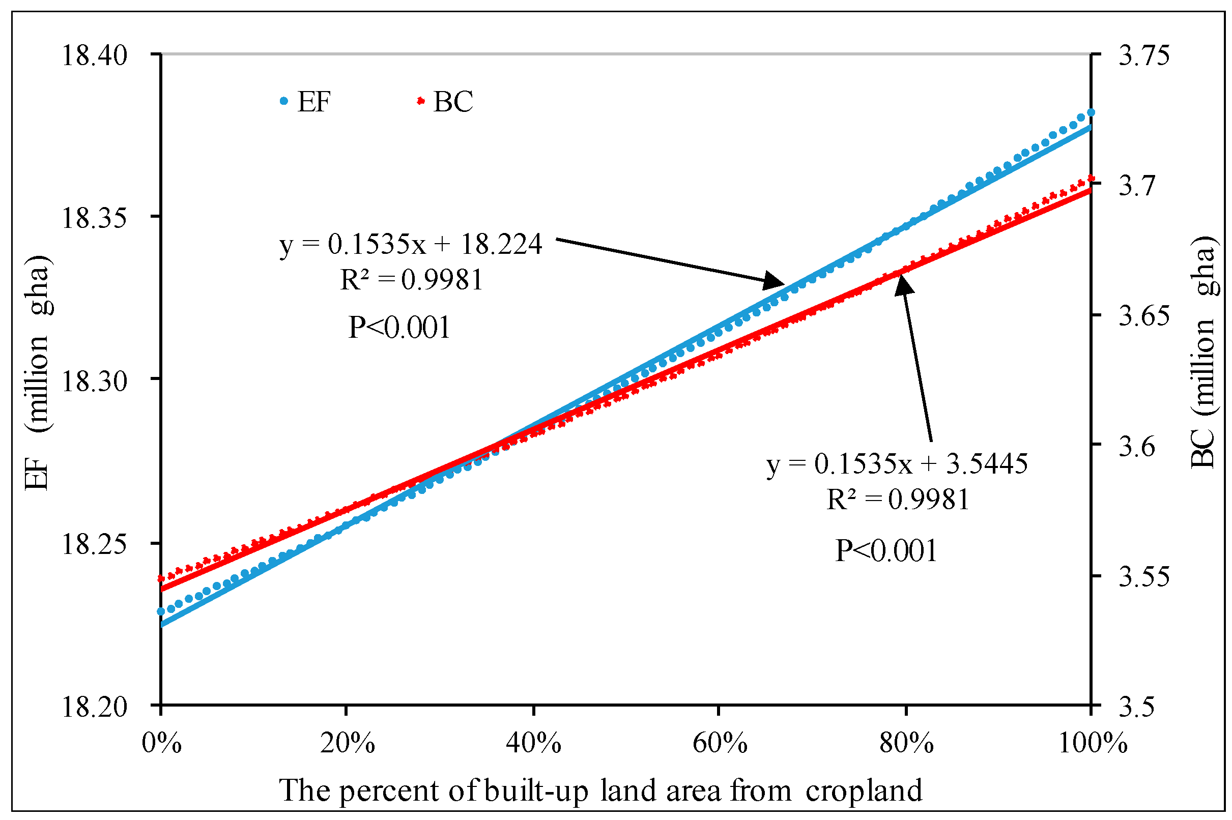
To further explore the impact of built-up land factors on the EF and BC, we used Kunming City as an example, and calculated the EF and BC under the different conversion ratios from cropland to built-up land. The ratio was set within 0 to 1, presenting the potential percentage of built-up land converted from other types. The ratio of 1 means that built-up land was completely from cropland. The proportion of built-up land from other land-use types is based on the proportion of forest, pasture, and fishing ground that accounted for their total area in 2010. The results were shown in the Figure 7. In Figure 5, we see that the EF and BC were positively correlated with the proportion of built-up land from cropland. The R2 was 0.9981, which indicated that the correlation was significant.
If the built-up land originated completely from cropland, we calculated that the EF was 18.38 million gha, and the BC was 3.70 million gha. If the built-up land was from other land-use types that did not contain cropland, then the EF was 18.23 million gha, and the BC was 3.55 million gha. Therefore, the EF and BC were reduced by 0.83% and 4.15%, respectively. In 2010, the EF of built-up land was 0.24 million gha of Kunming City, and the reduction of revised EF was equivalent to 63.85% of it. In other words, only 36.15% of built-up land were calculated. If the study area is highly urbanized, such as in eastern China, the figure of reduction is pretty large. The BC of fishing ground was 38 thousand gha, and the reduction of revised BC was about four times of it. In other words, we completely ignored the fishing ground in the BC calculation without the revisions, which is much less than the reduction. From that perspective, it is significant to revise the accounting method for calculating the EF and BC. In Figure 7, it can be seen that the growth rate of EF is greater than that of BC as the proportion of cropland increases. This result indicates that the EF is more sensitive to the sources of built-up land, and the sources of built-up land have a greater influence on the EF in the study area. The conclusion was identical to the previous section.
The calculation of land-use conversion is based on land uses from two periods, in other words, the source of the current land-use area is related to the previous year. In this study, the land-use data used were in 1980 and 2010, and if different land-use data were used, the accuracy of this calculation could be further improved. There are some uncertainties in calculating land-use conversion from different periods. For example, in the Dianchi Lake Basin of Kunming City, there were some reclaimed cropland from lake in 1970s. In the early 20th century, the urban was built around the lake which was mainly converted from the lake. The land-use data used in this study was from 1980, so the source of this part of built-up land was classified as cropland, but in fact, a significant part of it was derived from water. In the future, it is significant to use different land-use data to calculate the land-use conversion area, which is helpful to improve the accuracy.
4. Conclusions
The ecological footprints in Yunnan Province and Kunming City are much higher than their biocapacity, indicating unsustainable development modes in the regions. Under the current industrial structure, they rely heavily on fossil energy and the more developed the economy, the higher the dependence on fossil energy. This scenario is a typical resource and energy consuming economic development model. Therefore, energy is the bottleneck of sustainable economic growth in this region.
The influence of revised factors was undoubtedly related to the land-use composition. The larger the proportion of built-up land is, the greater the influence of the revision has on the EF and BC calculations. The revision led to a decrease in both EF and BC, with little effect on the entire structure and per capita, and a negligible effect on the ED.
The EF and BC were positively correlated with the proportion of built-up land converted from cropland, but the sensitivity of EF was larger. Therefore, the revision will greatly improve the accuracy of EF calculation in areas with a large proportion of built-up land. Extending the revised method to the scale of nation or worldwide, the influence will be small because of the small proportion of built-up land.
In this study, we chose Yunnan Province and Kunming City as cases studies for comparative studies at different scales. In the future, we can choose larger scales, such as national or world, or smaller scales, such as county, to further study the impact of revisions on ecological footprint calculations. This study focuses on revising built-up land parameters, and the other parameters are derived from global values. In the future, it is important to obtain local parameters through NPP, energy, and other methods, which can improve the accuracy of ecological footprint calculations further.
Author Contributions
Conceptualization, J.L. and W.G.; Data curation, J.L. and X.Z.; Formal analysis, J.L. and X.Z.; Original Draft Preparation, J.L.; and Review and Editing of Final Manuscript, X.C. and W.G.
Funding
Key Program of the National Natural Science Foundation of China (41701631), Natural Foundation for Youth Scholars of Yunnan Province of China (Y0120160068), and the Research of Endangered mechanism and Population Reconstruction of Key Species in Yunnan Plateau Lakes.
Acknowledgments
This work was supported by the Key Program of the National Natural Science Foundation of China (41701631), Natural Foundation for Youth Scholars of Yunnan Province of China (Y0120160068), and the Research of Endangered mechanism and Population Reconstruction of Key Species in Yunnan Plateau Lakes.
Conflicts of Interest
The authors declare no conflict of interest.
References
- Wackernagel, M.; Schulz, N.B.; Deumling, D.; Linares, A.C.; Jenkins, M.; Kapos, V.; Monfreda, C.; Loh, J.; Myers, N.; Norgaard, R. Tracking the Ecological Overshoot of the Human Economy. Proc. Natl. Acad. Sci. USA 2002, 99, 9266–9271. [Google Scholar] [CrossRef] [PubMed]
- Our Common Future; Oxford England Oxford University Press: Oxford, UK, 1987; Volume 11, pp. 53–78.
- Zijp, M.C.; Heijungs, R.; Ester, V.D.V.; Dik, V.D.M.; Huijbregts, M.A.J.; Hollander, A.; Posthuma, L. An Identification Key for Selecting Methods for Sustainability Assessments. Sustainability 2015, 7, 2490–2512. [Google Scholar] [CrossRef] [Green Version]
- Hardi, P.; Barg, S.; Hodge, T. Measuring Sustainable Development: Review of Current Practice. Occasional Paper Number 17. 1997, pp. 49–51. Available online: https://www.ic.gc.ca/eic/site/eas-aes.nsf/vwapj/op17e.pdf (accessed on 8 November 2018).
- Costanza, R.; Daly, H.E. Natural Capital and Sustainable Development. Conserv. Biol. 2010, 6, 37–46. [Google Scholar] [CrossRef]
- Castañeda, B.E. An index of sustainable economic welfare (ISEW) for Chile. Ecol. Econ. 1999, 28, 231–244. [Google Scholar] [CrossRef]
- Ress, W.E.W.M. Ecological Footprints and Appropriated Carrying Capacity: Measuring the Natural Capital Requirements of the Human Economy. Focus 1994, 6, 121–130. [Google Scholar]
- Verhofstadt, E.; Ootegem, L.V.; Defloor, B.; Bleys, B. Linking individuals’ ecological footprint to their subjective well-being. Ecol. Econ. 2016, 127, 80–89. [Google Scholar] [CrossRef]
- Xue, Q.; Song, W.; Zhang, Y.; Fengyun, M. Research Progress in Ecological Carrying Capacity: Implications, Assessment Methods and Current Focus. J. Resour. Ecol. 2017, 8, 514–525. [Google Scholar]
- Lee, Y.J.; Peng, L.P. Taiwan’s Ecological Footprint (1994–2011). Sustainability 2014, 6, 6170–6187. [Google Scholar] [CrossRef] [Green Version]
- Lewan, L.; Wackernagel, M. The ecological footprint and biocapacity of Sweden, a South Swedish region and a catchment area. In ConAccount workshop Ecologizing Societal Metabolism; CML: Leiden, the Netherlands, 1999; pp. 62–68. [Google Scholar]
- Haberl, H.; Erb, K.H.; Krausmann, F. How to calculate and interpret ecological footprints for long periods of time: The case of Austria 1926–1995. Ecol. Econ. 2004, 38, 25–45. [Google Scholar] [CrossRef]
- Ewing, B.; Reed, A.; Galli, A.; Kitzes, J.; Wackernagel, M. Calculation Methodology for the National Footprint Accounts. 2010. Available online: https://www.footprintnetwork.org/content/images/uploads/National_Footprint_Accounts_Method_Paper_2010.pdf (accessed on 11 March 2018).
- Galli, A.; Kitzes, J.; Wermer, P.; Wackermagel, M.; Niccolucci, V.; Tiezzi, E. An exploration of the mathematics behind the Ecological Footprint. Int. J. Ecodyn. 2008, 2, 250–257. [Google Scholar] [CrossRef]
- Ewing, B.; Moore, D.; Goldfinger, S.H.; Oursler, A.; Reed, A.; Wackernagel, M. Ecological Footprint Atlas 2010. B World Health Organ. 2010, 79, 971–979. [Google Scholar]
- Borucke, M.; Moore, D.; Cranston, G.; Gracey, K.; Iha, K.; Larson, J.; Lazarus, E.; Morales, J.C.; Wackernagel, M.; Galli, A. Accounting for demand and supply of the biosphere’s regenerative capacity: The National Footprint Accounts’ underlying methodology and framework. Ecol. Indic. 2013, 24, 518–533. [Google Scholar] [CrossRef]
- Monfreda, C.; Wackernagel, M.; Deumling, D. Establishing national natural capital accounts based on detailed Ecological Footprint and biological capacity assessments. Land Use Policy 2004, 21, 231–246. [Google Scholar] [CrossRef]
- Galli, A.; Giampietro, M.; Goldfinger, S.; Lazarus, E.; Lin, D.; Saltelli, A.; Wackernagel, M.; Müller, F. Questioning the Ecological Footprint. Ecol. Indic. 2016, 69, 224–232. [Google Scholar] [CrossRef]
- Wiedmann, T.; Barrett, J. A Review of the Ecological Footprint Indicator—Perceptions and Methods. Sustainability 2010, 2, 1645–1693. [Google Scholar] [CrossRef] [Green Version]
- Bastianoni, S.; Niccolucci, V.; Pulselli, R.M.; Marchettini, N. Indicator and indicandum: “Sustainable way” vs “prevailing conditions” in the Ecological Footprint. Ecol. Indic. 2012, 16, 47–50. [Google Scholar] [CrossRef]
- Kitzes, J.; Galli, A.; Bagliani, M.; Barrett, J.; Dige, G.; Ede, S.; Erb, K.; Giljum, S.; Haberl, H.; Hails, C. A research agenda for improving national Ecological Footprint accounts. Ecol. Econ. 2009, 68, 1991–2007. [Google Scholar] [CrossRef] [Green Version]
- Jiao, L.; Zhan, J.; Lin, Y.; Zhao, C. An equilibrium analysis of the land use structure in the Yunnan Province, China. Front. Earth Sci. 2014, 8, 393–404. [Google Scholar]
- Zhang, M.G.; Zhou, Z.K.; Chen, W.Y.; Jwf, S.; Cannon, C.H.; Raes, N. Using species distribution modeling to improve conservation and land use planning of Yunnan, China. Biol. Conserv. 2012, 153, 257–264. [Google Scholar] [CrossRef]
- Huang, B.R.; Cui, S.H.; Li, Y.M. Ecological Footprint Evolution Characteristics and Its Influencing Factors in China from 2000 to 2010. Huan Jing Ke Xue 2016, 37, 420–426. (In Chinese) [Google Scholar] [PubMed]
- Chen, B.; Chen, G.Q. Ecological footprint accounting based on emergy-A case study of the Chinese society. Ecol. Model. 2006, 198, 101–114. [Google Scholar] [CrossRef]
- Venetoulis, J.; Talberth, J. Refining the ecological footprint. Environ. Dev. Sustain. 2008, 10, 441–469. [Google Scholar] [CrossRef]
- Yang, H.B.; Wang, Z.M.; Zhao, H.L.; Li, J.R. Dynamic analysis of ecological footprint of Dongying City based on a modified model. J. Appl. Ecol. 2009, 20, 1753–1758. [Google Scholar]
- Liu, M.C.; Li, W.H. Calculation of equivalence factor used in ecological footprint for China and its provinces based on net primary production. J. Ecol. Rural Environ. 2010, 26, 401–406. (In Chinese) [Google Scholar]
- Yang, Q.; Liu, G.; Hao, Y.; Coscieme, L.; Zhang, J.; Jiang, N.; Casazza, M.; Giannetti, B.F. Quantitative analysis of the dynamic changes of ecological security in the provinces of China through emergy-ecological footprint hybrid indicators. J. Clean. Prod. 2018, 184, 678–695. [Google Scholar] [CrossRef]
- Word Wildlife Fund. Living Plant Report 2002. Available online: http://awsassets.panda.org/downloads/lpr_living_planet_report_2002.pdf (accessed on 18 March 2018).
- Wackernagel, M.; Onisto, L.; Bello, P.; Linares, A.C.; Falfán, I.S.L.; GarcíA, J.M.; Guerrero, A.I.S.; Ma, G.S.G. National natural capital accounting with the ecological footprint concept. Ecol. Econ. 1999, 29, 375–390. [Google Scholar] [CrossRef]
- Lee, Y.J. Land, carbon and water footprints in Taiwan. Environ. Impact Assess. Rev. 2015, 54, 1–8. [Google Scholar] [CrossRef]
- IPCC Special Report on Land Use, Land-Use Change and Forestry, 2000, Inter-Annual and Decadal Variability of Atmospheric CO2 Concentrations. Available online: http://www.grida.no/climate/ipcc/land_use/020.htm (accessed on 15 April 2018).
- ORNL. Estimate of CO2 Emission from Fossil Fuel Burning and Cement Manufacturing; ORNL/CDIAC-25; Carbon Dioxide Information Analysis Center, Oak Ridge National Laboratory: Oak Ridge, TN, USA, 1990.
- Yao, X.; Wang, Z.; Zhang, H. Dynamic Changes of the Ecological Footprint and Its Component Analysis Response to Land Use in Wuhan, China. Sustainability 2016, 8, 329. [Google Scholar] [CrossRef]
- China National Current Land Use Classification Standard (GB/T 21010-2017). 2017. Available online: http://c.gb688.cn/bzgk/gb/showGb?type=online&hcno=224BF9DA69F053DA22AC758AAAADEEAA (accessed on 15 October 2018).
- Zhang, Z.; Wang, X.; Zhao, X.; Liu, B.; Yi, L.; Zuo, L.; Wen, Q.; Liu, F.; Xu, J.; Hu, S. A 2010 update of national land use/cover database of China at 1:100000 scale using medium spatial resolution satellite images. Remote Sens. Environ. 2014, 149, 142–154. [Google Scholar] [CrossRef]
- Lai, L.; Huang, X.; Yang, H.; Chuai, X.; Zhang, M.; Zhong, T.; Chen, Z.; Chen, Y.; Wang, X.; Thompson, J.R. Carbon emissions from land-use change and management in China between 1990 and 2010. Sci. Adv. 2016, 2, e1601063. [Google Scholar] [CrossRef] [PubMed] [Green Version]
- Zhou, Y.; Xiao, X.; Qin, Y.; Dong, J.; Zhang, G.; Kou, W.; Jin, C.; Wang, J.; Li, X. Mapping paddy rice planting area in rice-wetland coexistent areas through analysis of Landsat 8 OLI and MODIS images. Int. J. Appl. Earth Obs. Geoinf. 2016, 46, 1–12. [Google Scholar] [CrossRef] [PubMed] [Green Version]
- Deng, J.S.; Wang, K.; Hong, Y.; Qi, J.G. Spatio-temporal dynamics and evolution of land use change and landscape pattern in response to rapid urbanization. Landsc. Urban Plan. 2009, 92, 187–198. [Google Scholar] [CrossRef]
- Yunfeng, H.; Batunacun, Y. An analysis of land-use and land-cover change in the Zhujiang–Xijiang Economic Belt, China, from 1990 to 2017. Appl. Sci. 2018, 8, 1524. [Google Scholar]
- Zenebe, M.; Habitamu, T.B.; Teshale, W.; Zebene, A.; Habtemariam, K. Land use and land cover changes and the link to land degradation in Arsi Negele district, Central Rift Valley, Ethiopia. Remote Sens. Appl. Soc. Environ. 2018, 12, 1–9. [Google Scholar]
- Gao, J.; Tian, M. Analysis of over-consumption of natural resources and the ecological trade deficit in China based on ecological footprints. Ecol. Indic. 2016, 61, 899–904. [Google Scholar] [CrossRef]
- Long, H.; Tang, G.; Li, X.; Heilig, G.K. Socio-economic driving forces of land-use change in Kunshan, the Yangtze River Delta economic area of China. J. Environ. Manag. 2007, 83, 351–364. [Google Scholar] [CrossRef] [PubMed]
- Parcerisas, L.; Marull, J.; Pino, J.; Tello, E.; Coll, F.; Basnou, C. Land use changes, landscape ecology and their socioeconomic driving forces in the Spanish Mediterranean coast (El Maresme County, 1850–2005). Environ. Sci. Policy 2012, 23, 120–132. [Google Scholar] [CrossRef]
- Xie, Y.; Yu, M.; Tian, G.; Xing, X. Socio-economic driving forces of arable land conversion: A case study of Wuxian City, China. Glob. Environ. Chang. 2005, 15, 238–252. [Google Scholar] [CrossRef]
- Ding, Y.; Peng, J. Impacts of Urbanization of Mountainous Areas on Resources and Environment: Based on Ecological Footprint Model. Sustainability 2018, 10, 765. [Google Scholar] [CrossRef]
- Lu, Y.; He, D.; Buchanan, S.; Liu, J. Ecological Footprint dynamics of Yunnan, China. J. Mt. Sci.-Engl. 2009, 6, 286–292. [Google Scholar] [CrossRef]
- Liu, L.; Lei, Y.; Ge, J.; Yang, K. Sector screening and driving factor analysis of Beijing’s ecological footprint using a multi-model method. J. Clean. Prod. 2018, 191, 330–338. [Google Scholar] [CrossRef]
- Yang, Y.; Ling, S.; Zhang, T.; Yao, C. Three-dimensional ecological footprint assessment for ecologically sensitive areas: A case study of the Southern Qin Ling piedmont in Shaanxi, China. J. Clean. Prod. 2018, 194, 540–553. [Google Scholar] [CrossRef]
- Luo, W.; Bai, H.; Jing, Q.; Liu, T.; Xu, H. Urbanization-induced ecological degradation in Midwestern China: An analysis based on an improved ecological footprint model. Resour. Conserv. Recycl. 2018, 137, 113–125. [Google Scholar] [CrossRef]
- Yin, Y.; Han, X.; Wu, S. Spatial and temporal variations in the ecological footprints in northwest China from 2005 to 2014. Sustainability 2017, 9, 597. [Google Scholar] [CrossRef]
Figure 1.
Location and land use of Yunnan Province and Kunming City in 2010.

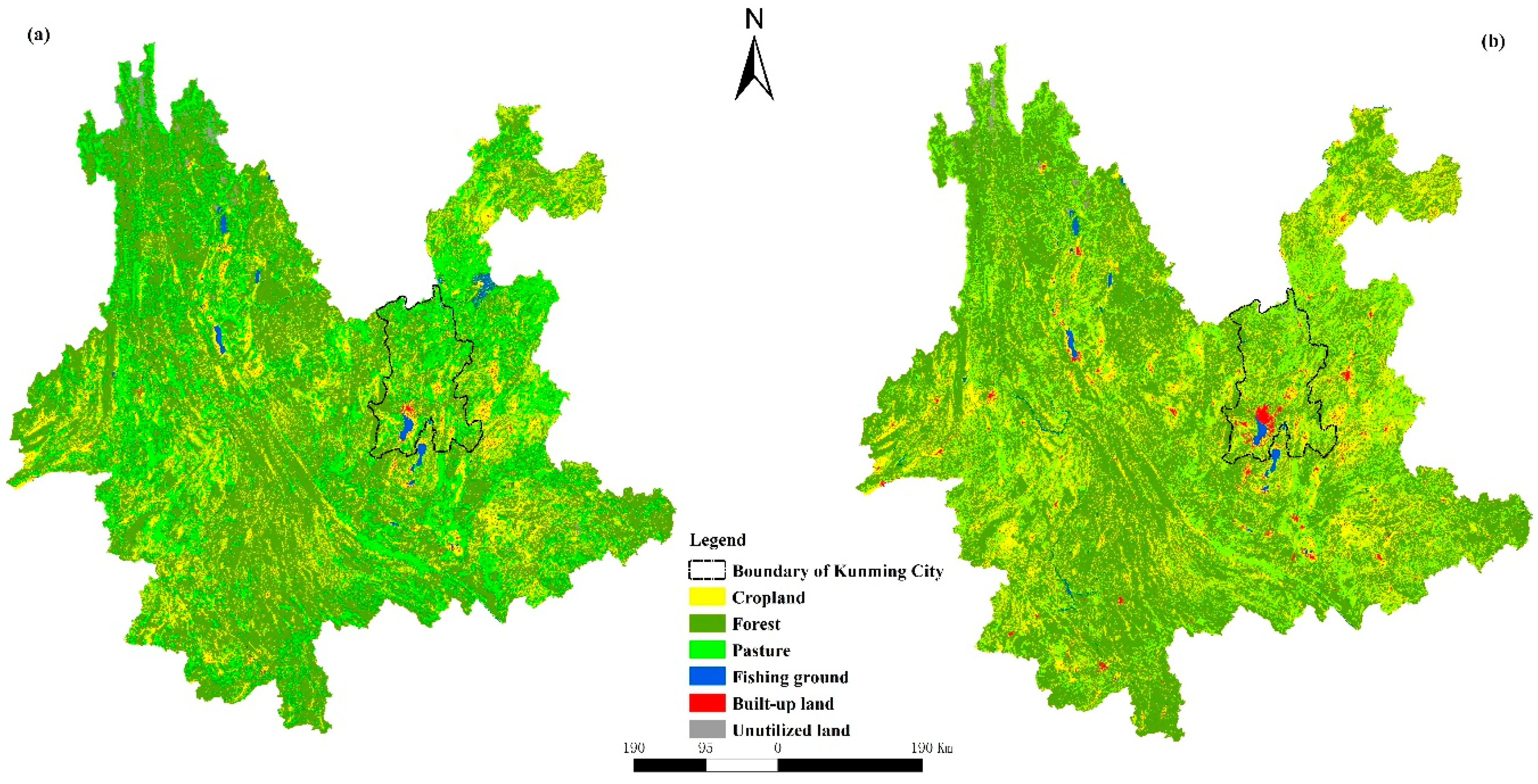
Figure 2.
Land use of Yunnan Province and Kunming City in (a) 1980 and (b) 2010.

Figure 3.
The conversion source for built-up land in Yunnan Province and Kunming City between 1980 and 2010.
Figure 3.
The conversion source for built-up land in Yunnan Province and Kunming City between 1980 and 2010.

Figure 4.
The yield and equivalence factors of built-up land in Yunnan Province and Kunming City.

Figure 5.
The EF of various components with revision and with no revision.

Figure 6.
The EF of various components with revision and no revision.

Figure 7.
The EF and BC of Kunming City under different percent of built-up land area from cropland.
Figure 7.
The EF and BC of Kunming City under different percent of built-up land area from cropland.


Table 1.
The kind of products included in each area.
| Components | Items | Biological Resources and Energy Types |
|---|---|---|
| Biological resources | Cropland | cereals, veg and fruit, sugar, edible vegetable oil, egg, pork, poultry |
| Pasture | bovine, goat, mutton and buffalo meat, milk | |
| Forest | fire wood, sawn wood, wood-based panels, wood pulp, paper and paperboard | |
| Fishing ground | aquatic products | |
| Built-up land | buildings | |
| Carbon footprint | Fossil fuels | coal, fossil gas, liquid fossil fuel |
Table 2.
The ecological footprint (EF) of fossil fuel-carbon.
| Category | Amount Consumed (t) | Carbon Emissions (t) | Fossil Energy Land (gha) |
|---|---|---|---|
| Coal * | 49,208,566.41 | 35,203,808.41 | 28,994,798.68 |
| Liquid fossil fuel * | 13,106,670.87 | 9,376,512.34 | 4,952,383.28 |
| Fossil gas * | 485,753.52 | 347,508.07 | 183,542.99 |
| Total | 62,800,990.8 | 44,927,828.82 | 34,130,724.95 |
* The amount of consumption of fossil fuel has been transformed to standard coal.
Table 3.
The biocapacity (BC) of Yunnan under different assumptions
| Land Use | Area (ha) | Revision (gha) | No Revision (gha) |
|---|---|---|---|
| Cropland | 6,855,811.11 | 24,323,046.67 | 24,323,046.67 |
| Forest | 22,029,953.08 | 34,353,508.84 | 34,353,508.84 |
| Pasture | 8,669,372.65 | 6,241,948.31 | 6,241,948.31 |
| Fishing ground | 287,044.18 | 225,272.27 | 225,272.27 |
| Built-up land | 308,361.78 | 879,447.78 | 1,094,005.91 |
© 2018 by the authors. Licensee MDPI, Basel, Switzerland. This article is an open access article distributed under the terms and conditions of the Creative Commons Attribution (CC BY) license (http://creativecommons.org/licenses/by/4.0/).
Share and Cite
MDPI and ACS Style
Li, J.; Zhang, X.; Chang, X.; Gao, W. Revising Yield and Equivalence Factors of Ecological Footprints Based on Land-Use Conversion. Sustainability 2018, 10, 4107. https://doi.org/10.3390/su10114107
AMA Style
Li J, Zhang X, Chang X, Gao W. Revising Yield and Equivalence Factors of Ecological Footprints Based on Land-Use Conversion. Sustainability. 2018; 10(11):4107. https://doi.org/10.3390/su10114107
Chicago/Turabian StyleLi, Jincheng, Xinyue Zhang, Xuexiu Chang, and Wei Gao. 2018. "Revising Yield and Equivalence Factors of Ecological Footprints Based on Land-Use Conversion" Sustainability 10, no. 11: 4107. https://doi.org/10.3390/su10114107
Note that from the first issue of 2016, this journal uses article numbers instead of page numbers. See further details here.