Article

Quantifying the Spatiotemporal Dynamics of Industrial Land Uses through Mining Free Access Social Datasets in the Mega Hangzhou Bay Region, China

1
Institute of Agricultural Remote Sensing and Information Technology, College of Environmental and Resource Sciences, Zhejiang University, Hangzhou 310058, China
2
School of Information Engineering, Zhejiang Agriculture and Forestry University, Hangzhou 311300, China
3
Beijing Research Center for Agri-Food Testing and Farmland Monitoring, Beijing Academy of Agriculture and Forestry Sciences, Beijing 100097, China
*
Author to whom correspondence should be addressed.
Sustainability 2018, 10(10), 3463; https://doi.org/10.3390/su10103463
Submission received: 18 July 2018 / Revised: 20 September 2018 / Accepted: 22 September 2018 / Published: 28 September 2018

Abstract

:
China has experienced rapid industrial growth over the last three decades, leading to diverse social and environmental issues. In the new industrialization era, it is urgent to quantify industrial land use (ILU) dynamics for sustainable industrial management, yet there have been limited attempts to systematically quantify these changes, especially in large-scale areas. Through points-of-interest (POIs), a free access geospatial big data, we developed a new framework for exploring ILU dynamics in the mega Hangzhou Bay region (MHBR). The ILU was identified by using natural language processing to mine the semantic information of industrial POIs from 2005, 2011, and 2016. Then, a two-step approach that integrated statistical analysis and hotspots detection was introduced to quantify the changes. The results revealed that traditional industries such as textile products and apparel manufacturing, unspecific equipment manufacturing, and electrical machinery and components manufacturing were dominant types across MHBR, with the enterprise number reaching 14,543, 9412, and 4374, respectively, in 2016. The growth rates of these traditional industries dropped during 2011–2016, while the growth rates of new industries such as Internet information industry and logistics industry increased remarkably, particularly in Hangzhou and Ningbo. Additionally, traditional industrial factories mainly expanded in the urban periphery and coastal zones, whereas new industries mainly grew in the urban center. Shrinkages in the hotspots of traditional industries between 2011 and 2016 were also observed. Our study provides a detailed spatial view of ILU, indicating that MHBR has undergone an industrial transition from traditional industry to new industry.

Graphical Abstract

1. Introduction

China has undergone a spectacular industrial boom along with huge industrial land expansion under persistent structural reform since 1978. The industrialization has brought great economic benefits and has become the dominant power of China’s national economy [1,2]. However, due to inefficient supervision, industrial land is generally used inefficiently in China [3,4]. Industrial land occupies more than 20% of the built-up land, the ratio is far beyond that of many developed countries, indicting the gap between China and developed countries [5]. In some developed areas of China, such as Shanghai and Zhejiang, the percentages of the industrial land to the total built-up, are as high as 26.5% and 24.1% [6]. Furthermore, industrial emissions from some traditional heavy industries, for example, petrochemical industries and metallurgical industries, have threatened the urban soil [7] and atmosphere [8], as well as the watershed [9]. Moreover, excessive inputs of synthetic chemicals and heavy metals may be attributed to potential human health risks [10].
With the arrival of the new industrialization era, China has emphasized that it is vitally important to optimize industrial land uses (ILU) to promote regionally sustainable industrial development [11,12]. To achieve faster, better and more environment-friendly development of industry, in 2012, Chinese central government formally proposed “industrial transformation and upgrading layout (2011–2015)”. This was the first plan that was specifically targeted on industry since opening-up reform [13]. In 2015, “Chinese manufacturing for 2025” was further released to address the significance of structural and spatial adjustments of industrial manufacturing [14]. The process of industrial transformation and upgrading is not only the essential part to accelerate the transformation of economic development mode, but also the inevitable course for China to switch the role from a large industrial country to a powerful industrial country [15]. Hence, quantifying the spatiotemporal patterns of ILU in the past accurately and comprehensively is urgently needed for further industrial management and sustainable development.
Urban agglomerations, groups of cities around regional economic core cities, have become a new regional unit in global competition and international division [16]. However, scant attention is paid to the spatial dynamics of ILU at the urban agglomeration level. Several studies generally focus on the typical economic development zone or the single-city scale based on cadastral surveys [17,18]. Other studies mainly utilize industry economic datasets at the administration level to reflect the spatial differences in industrial activities among different cities [19,20], which leaves details within the city unknown.
Thus far, cadastral survey data are considered the most favorable data theoretically to explore the dynamics of ILU [21]. However, these data are neither easy to access nor permitted to be released publicly in China [22]. Very-high-resolution (VHR) images are advantageous for monitoring physical changes of industrial land because of the high levels of detailed features [23]. Recent years have witnessed significant progress in urban land use mapping using VHR images based on objected-oriented classification [24,25]. Diverse urban land use functions could be detected, such as commercial and industrial areas, residential areas because of the spectral, shape, texture features and neighborhood graphs extracted from VHR images [26]. Nevertheless, it is still a difficult task to detect multiple ILU based on pure VHR images. Because VHR images do not provide sufficient information on human activities, as industrial land use is a cultural concept that describes industrial activities and their uses of land [27]. Furthermore, due to the narrow spatial coverage and high cost, these images are difficult to extend to large regions [28]. Industry economic panel data can record main indicators of industrial enterprises above designated size, including number of enterprises at city level, gross industrial output value, rate of production sold, etc. This data represents the overall industrial situation at the city level, and is widely used in analyzing the economic performance of the cities [20]. However, this data does not have the precise location of industrial enterprises.
In recent years, online volunteered geographic information (VGI) has emerged as a new data source, making it possible to capture the land use dynamics of built-up areas at a finer level [29]. One promising type of VGI for our purpose is points-of-interest (POIs) data. Each POIs is the abstract expression of a geographical entity. Efforts have been made to use POIs to delineate urban function areas [30,31,32]. Yuan et al. (2012) introduced a Latent Dirichlet Allcoation model to fully mine the semantic information of POIs related to urban land uses, thus successfully mapped different regions of urban functions and improved the overall accuracy [33]. Through integrating a Google Word2Vec model with POIs, Yao et al. (2016) conducted an innovative framework to extract POIs vectors and identified urban land use distributions at the city block level [31]. The results show that POIs have great potential to characterize the intra-urban functions at fine spatial resolution and at a large scale [28]. The abovementioned studies generally focus on sensing the urban land uses (commercial area, residential area, and industrial area, etc.) based on POIs, yet few attempts have been taken to quantify ILU dynamics by integrating the industrial POIs, a typical category of POIs. Industrial POIs’ coordinates can show the precise geographic location of industrial enterprises, while the names of industrial POIs can reflect specific industrial activities. Therefore, making full use of both the location and semantic information of POIs can help us understand the spatial patterns of ILU.
This paper aims to improve public understanding of the spatiotemporal patterns of ILU. First, we introduce a natural language processing based method to mine the semantic information of industrial POIs and to identify the multiple ILU. Second, a two-step approach that integrates statistical analysis and hotspots detection is developed to quantify the spatiotemporal dynamics of ILU. The mega Hangzhou Bay region (MHBR), one of the most rapidly urbanizing and industrializing megalopolises in eastern China is chosen as our study area. We examine the ILU dynamics during 2005–2011 and 2011–2016, as the year 2011 is the time when the plan of industrial transformation and upgrading was published by the central government.
This study seeks to answer the following specific questions: (1) how is the size of different industrial land uses changing? And (2) where are different industrial land uses expanding or migrating? The analysis provides government officials with detailed information on industrial changes to aid in enacting integrated development plans. Recommendations and implications for regional industrial growth can also be obtained.

2. Study Area and Data Preparation
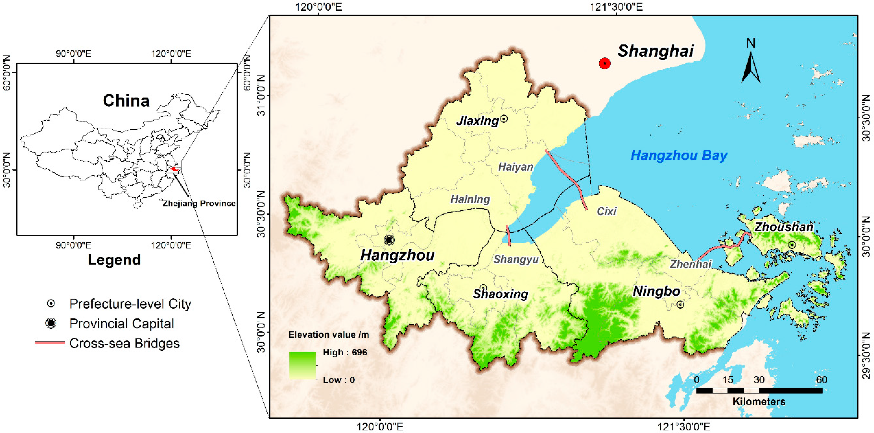
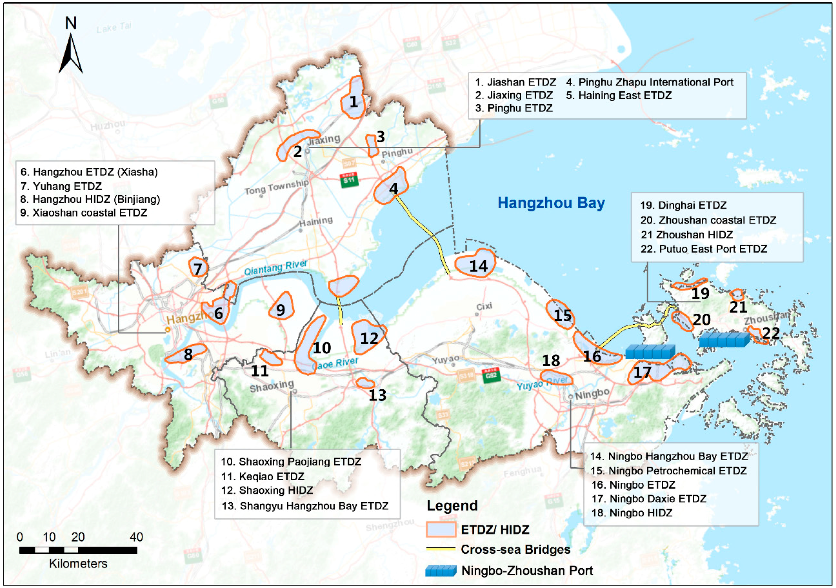
2.1. Study Area

The MHBR is located in Northern Zhejiang Province and Southeastern Shanghai (119°41′–122°28′ E, 29°42′–31°02′ N) (Figure 1). The total area of the MHBR is approximately 17,497 km2. It includes five megacities: Hangzhou, Ningbo, Shaoxing, Jiaxing, and Zhoushan. Hangzhou is the capital of Zhejiang Province; it is known as a famous cultural city with glorious scenery, and one of the important e-commerce centers of China; Ningbo is a mega port city of China with Ningbo Port located along the coastline. Ningbo Port has handled 88.9 million tons of cargo in 2015, ranking the first in the world [34]. Shaoxing is famous as the “textile hub” of China [35]; Jiaxing is a national historical and cultural city, as well as the home of silk; Zhoushan is an islands city and China’s largest seafood production, processing and sales base [36].
This area has been undergoing rapid urbanization and economic development. The gross domestic product has increased from 179.7 billion RMB in 1996 to 1959.6 billion RMB in 2016 [37]. Regional block economy is the dominant industrial form and a powerful engine in accelerating economic growth across the MHBR. Evident regional divergences in ILU have emerged [38]. For instance, the textile industry is a traditional pillar industry in Shaoxing and Jiaxing, the logistics industry and electrical machinery industry play important roles in Ningbo, the logistics industry is the dominant industry in Zhoushan, and the Internet information industry has been prosperous in Hangzhou in recent years.
MHBR have been facilitated with Hangzhou Bay Bridge, the third longest ocean-crossing bridge in the world with an overall length of 36 kilometers [39]. In 2003, the report “Urban agglomeration space developing strategy planning around Hangzhou Bay, Zhejiang Province” was released [40]. The planning first announced the goals of MHBR industrial belt development. “Powerful Zhejiang province construction depending on industry planning” was published in 2012 [41]. Both of these reports addressed the mechanism of the development of the industrial belt across the MHBR. Thus, the MHBR has been regarded as a pilot area by central government to implement economic industrial transition and upgrading measures. Therefore, the MHBR provides a typical study area for ILU monitoring.

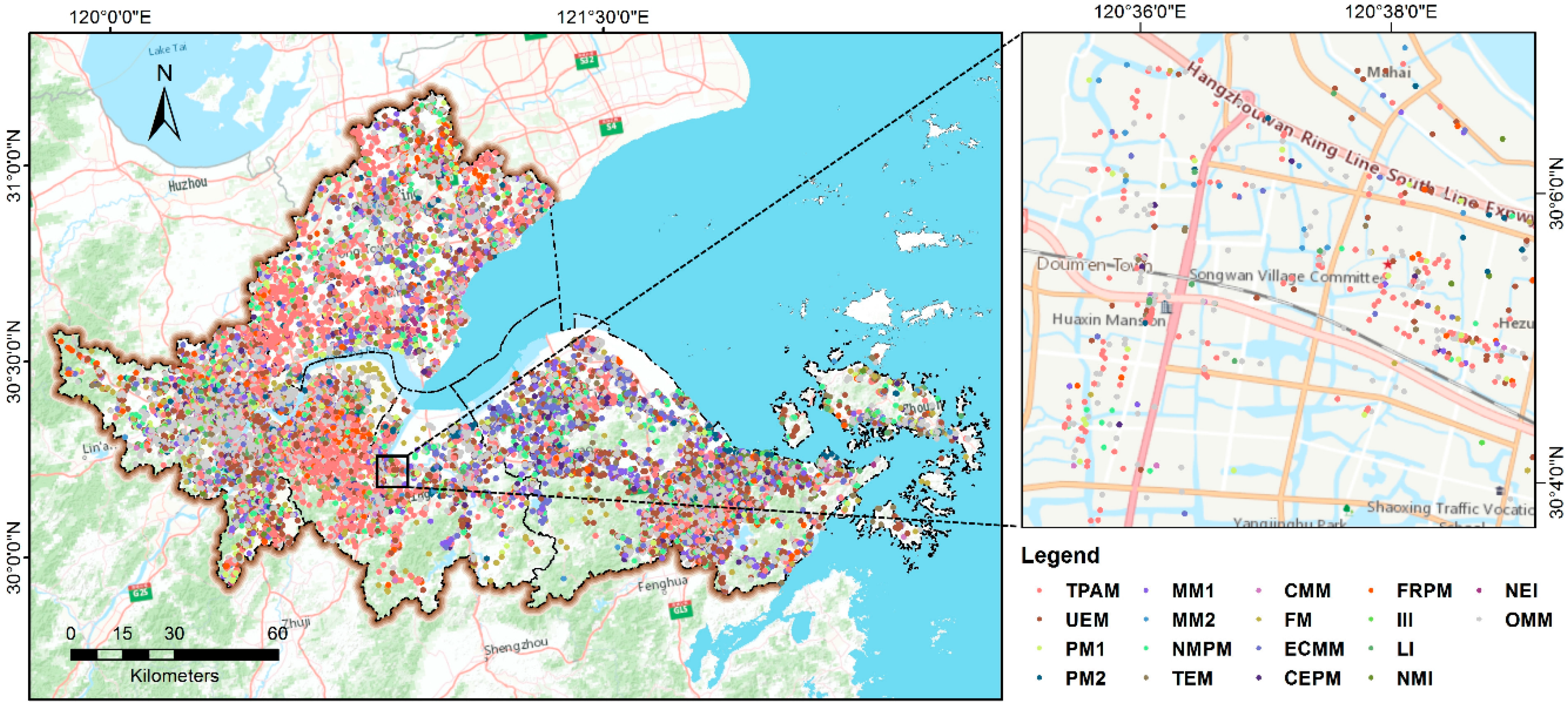
2.2. Data Preparation
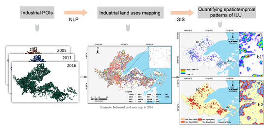
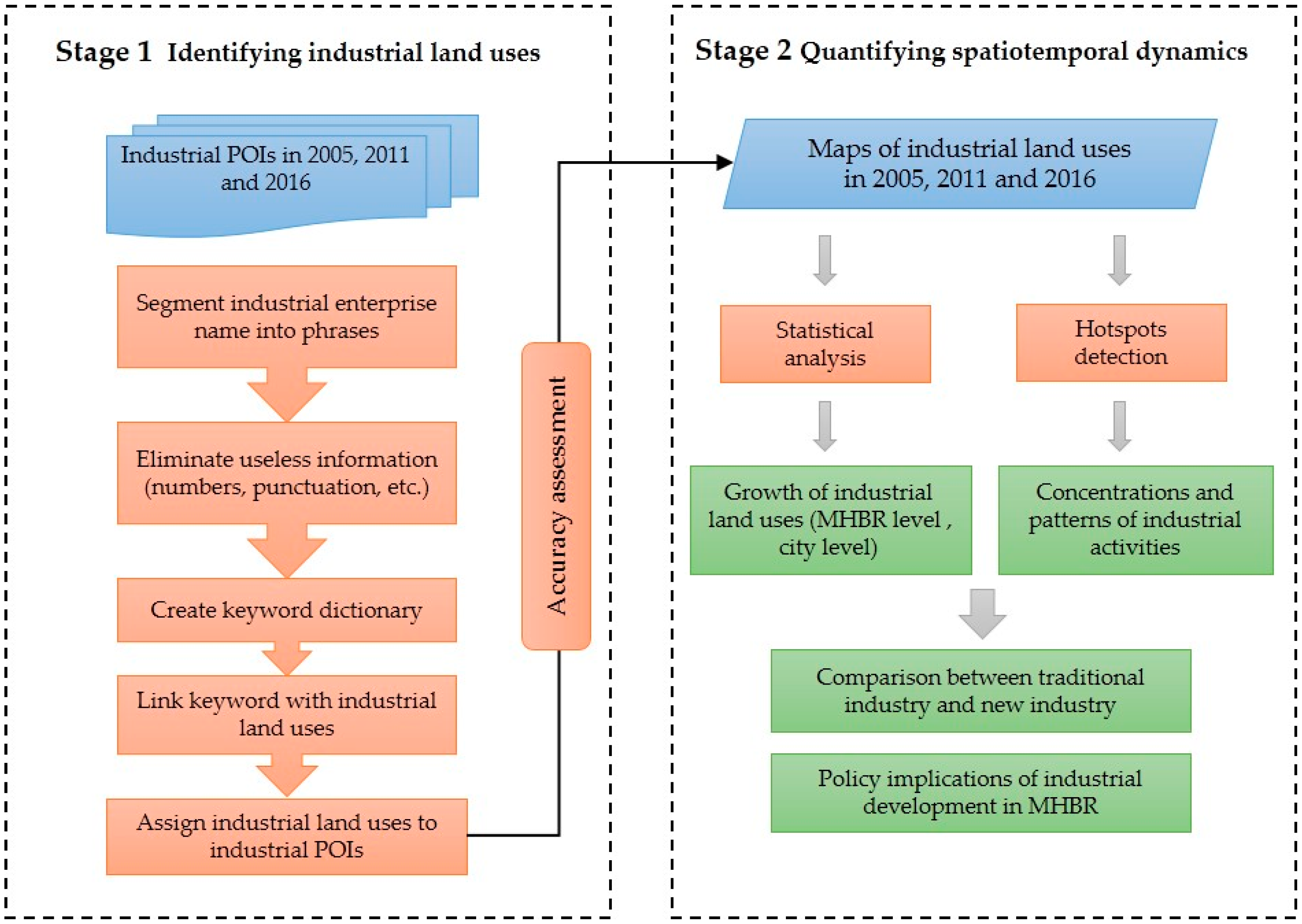
The detailed datasets used in this study are as follows: (1) The POIs datasets were obtained from application programming interfaces (APIs) provided by Gaode Map API (http://lbs.amap.com/). The POIs include diversified types, such as education, entertainment, residential, industrial, etc. We selected industrial POIs, including 16,678 records in 2005, 45,821 records in 2011, and 74,614 records in 2016. Each industrial POIs records six attributes’ values: city code, enterprise name, address, telephone number, x-coordinates and y-coordinates. The quality of industrial POIs was validated by checking 500 randomly sampled sites manually in each period, and the accuracy level was 96.0%, 97.8%, and 97.2%, respectively; (2) high-resolution historical Google Earth images in 2005, 2011 and 2016 from Google Earth Map were used for auxiliary validation.

3. Methodology

The framework proposed for this study consists of two stages, as shown in Figure 2: (1) identifying ILU using natural language processing and (2) quantifying spatiotemporal dynamics including statistical analysis and hotspots detection.

3.1. Identifying Industrial Land Uses Using Natural Language Processing

Based on the latest regulation of “National Economic Industry Classification Criterion (GB/T4754-2011)” and MHBR industrial characteristics, the ILU were aggregated into eighteen classes that fall into three primary groups: traditional industry, new industry, and other miscellaneous manufacturing. The description and corresponding industry are displayed in Table 1.
In this section, the initial task is to divide the text information of each industrial POIs into segments to identify keywords related to industrial use and then perform the industrial use classification. Natural language processing is capable of extracting and mining the useful textural information from numerous industrial POIs [42]. To make our framework operational and portable, first, an open-access tool called Jieba (https://github.com/fxsjy/jieba) was applied to segment each enterprise name into phrases. Second, useless information such as numbers, punctuation and personal names were eliminated, leaving the words related to industrial type. The remaining words were treated as a keyword dictionary, in which every word could provide evidence for industrial use classification. Then, the words were sized down by frequency and manually matched to the industrial use classes according to Chinese word connotations. Finally, corresponding ILU were assigned to each industrial POIs.
To validate the identification result, a total of 952 industrial POIs were randomly selected for construction of the error matrix. Then, their properties and business scope were checked on the National Enterprise Credit Information Publicity System (http://zj.gsxt.gov.cn) to confirm whether the selected industrial POIs were correctly identified. The information of industrial enterprises on this website is controlled and qualified by local administration for industry and commerce.

3.2. Analysis of Enterprise Number and Growth Rate of Industrial Land Uses

The enterprise number of each industrial use type in each year was calculated to quantify industry size and analyze temporal dynamics. The annual growth rate of industrial enterprises in different uses (GR, %) was further calculated with the following equation:
G R = N t 2 N t 1 Δ t × N t 1
where N t 1 and N t 2 are the enterprise number of a certain industrial use type in year t 1 and t 2 , respectively, and Δ t is the number of years between t 1 and t 2 .

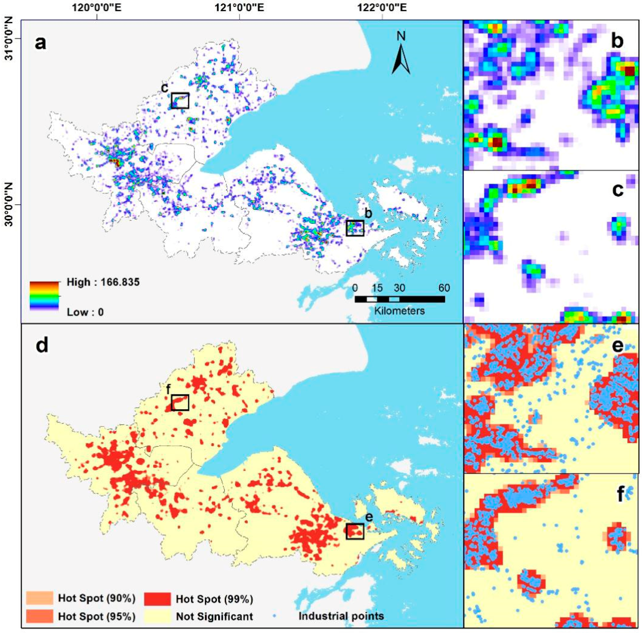
3.3. Hotspots Detection

Local spatial autocorrelation based on a kernel density estimator was applied to profile the hotspots of multiple industrial use types. By the integration of local spatial autocorrelation and kernel density analysis, it measures not only the density value of each industrial use but also the hotspots map in the study area [43]. First, each type of industrial POIs data was aggregated by using a kernel density estimator. The kernel density estimator f ( x , y ) was computed with the following equation:
f ( x , y ) = 1 n h 2 i = 1 n K ( d i h )
where f ( x , y ) is the density estimated at the location of observation ( x , y ) , n is the total number of observations, K is the kernel function, h is the bandwidth parameter, and di is the distance from the observation ( x , y ) to the ith observation. The bandwidth parameter h usually determines the smoothness of the estimated density. A larger h achieves smoother density distribution while a smaller h reveals more detailed peaks and valleys. Liu et al. (2018) identified the boundaries of urbanized areas at the urban agglomeration level based on kernel density estimator using POIs data, and found the bandwidth which was suitable and exerted a remarkable effect on the results is between 1000 and 2000 m [44]. Concerning the study area, the bandwidth h was set in 1000 m.
Second, local spatial autocorrelation with the Getis-Ord Gi* statistic was used to identify the clusters of high- and low-density values [45,46,47]. The Getis-Ord Gi* statistic was expressed with the following equation:
G i * = j = 1 n w i j x j X ¯ j = 1 n w i j S [ n j = 1 n w i j 2 ( j = 1 n w i j ) 2 ] n 1
where
S = j = 1 n x j 2 / n ( X ¯ ) 2
x j is the density value in the jth observation unit. For each observation unit, the density value is the mean value of the cells obtained from the kernel density estimator within the unit. X ¯ is the mean of x j , w i j is the spatial weight between unit i and unit j, and n is the total number of observation units. As for MHBR, the size of unit was set in 500 m × 500 m, because if the size of unit is too small, the information will be excessively descriptive, while if the output cell size of unit is too large, important information will be lost.
The Gi* statistic can be interpreted as a z-score. For an observation unit, a positive z-score indicates a hotspot of high values. In contrast, a negative z-score implies a cold spot of low values. A z-score close to zero indicates a random distribution or a mix of high and low clustering. A p-value means probability which is used to determine whether the unit is at a statistically significant level or not. Finally, the units with a z-score greater than 1.96 and p-value at the significance level of 0.05 were selected to generate the hotspots map for each industrial use type.

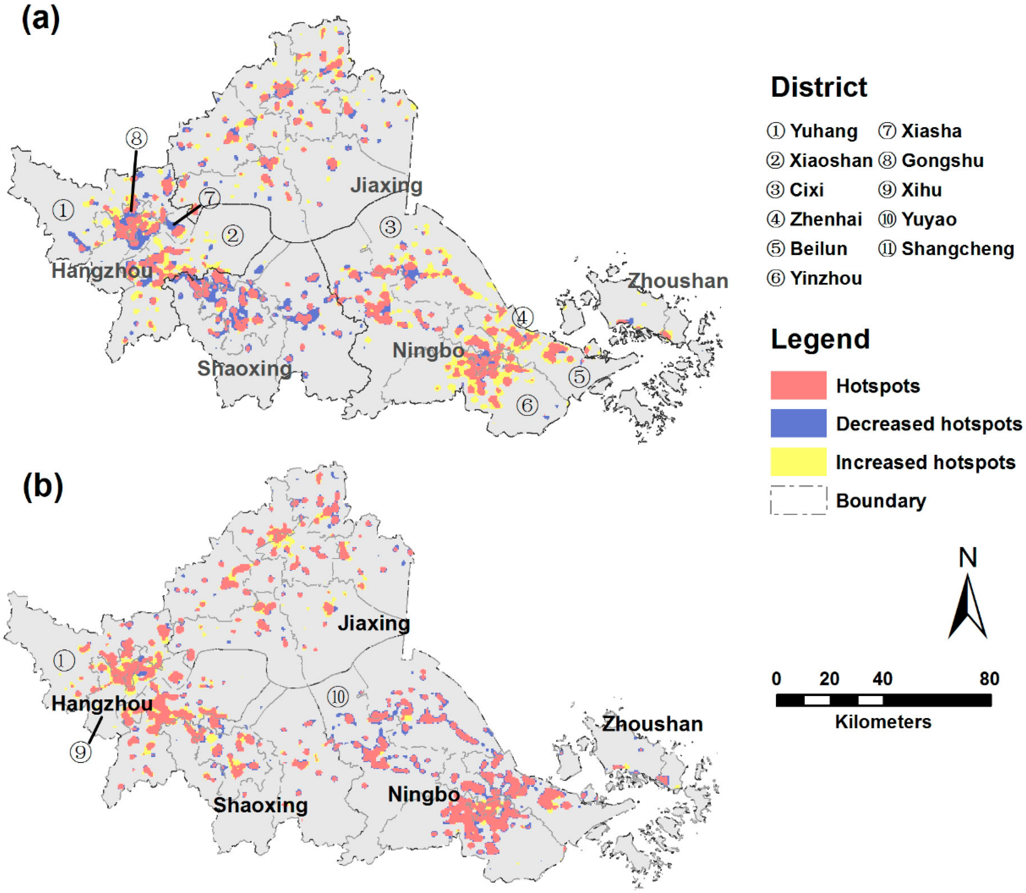
4. Results and Analysis

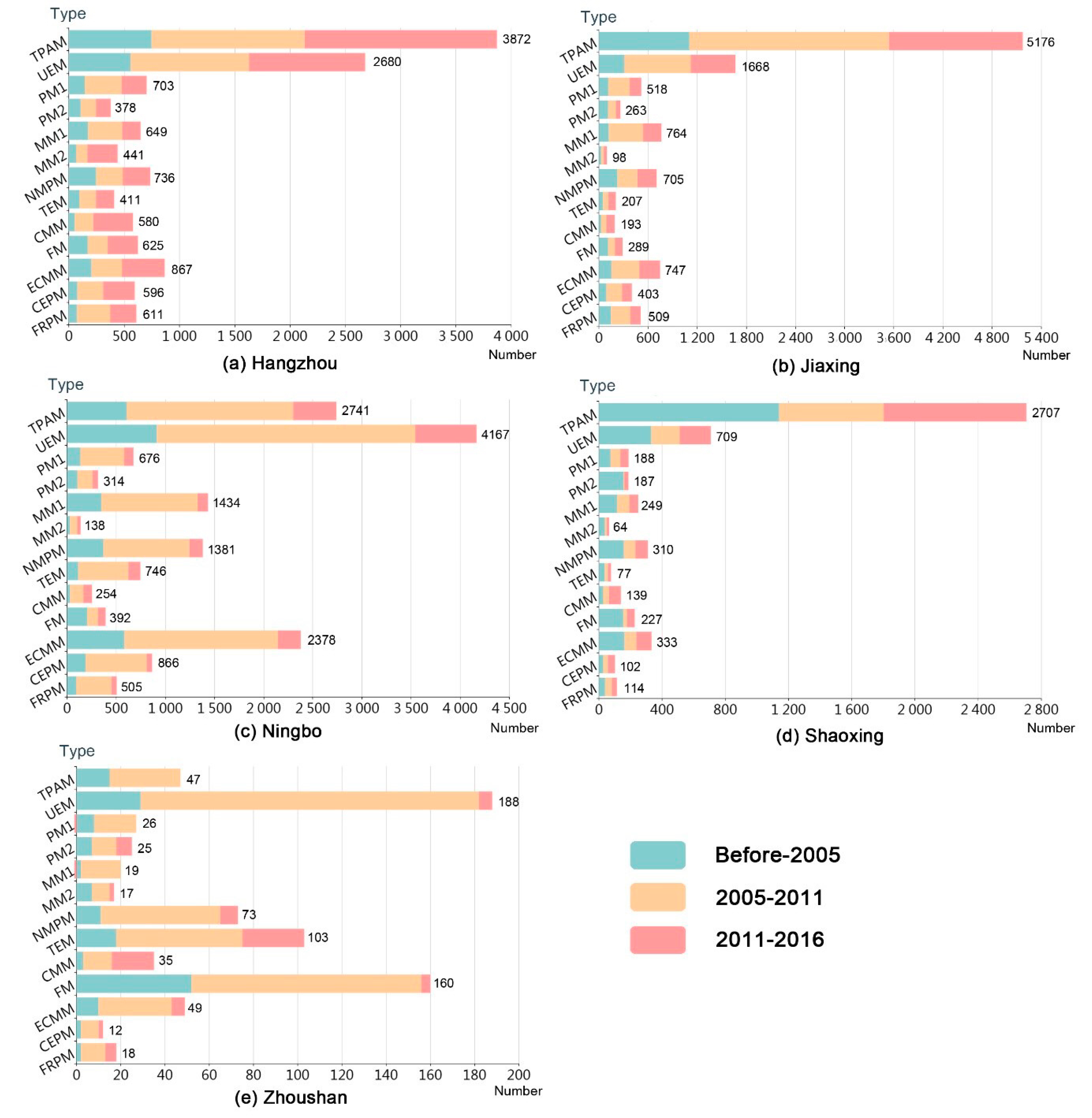
4.1. Industrial Land Uses Change Detection

The identification accuracies of ILU are presented in Table A1. In general, the proposed method is effective for identifying ILU (Figure 3), with an overall accuracy of 87.29%. The user’s accuracy (UA) for specific industrial use types ranged from approximately 76% to 94%, and nearly all of the accuracies were greater than 80%. The new energy industry (NEI) had the highest producer’s accuracy (PA) value of 100%, whereas other miscellaneous manufacturing (OMM) had a relatively low PA value of 57%. The OMM category can be easily confused with food manufacturing (FM), furniture and related product manufacturing (FRPM), metallurgical manufacturing (MM1) and the logistics industry (LI), probably because the names of several enterprises may not reflect their uses, which can be difficult to determine based on the corresponding keyword related to a certain industrial use.

4.2. Growth of Industrial Regions at the MHBR Level.

The total number and annual growth rate of industrial enterprises in different uses during the study period are depicted in Table 2. We found that in terms of the whole MHBR, traditional industries such as textile products and apparel manufacturing (TPAM), unspecialized equipment manufacturing (UEM), electrical machinery and component manufacturing (ECMM), and non-metallic product manufacturing (NMPM) were dominant industrial types during the period 2005–2016. The enterprise number of TPAM remained the highest, with values of 3616, 9825, and 14,543, accounting for 21.7%, 21.4%, and 19.5%, respectively, of the total in the years of 2005, 2011 and 2016. UEM had the second highest enterprise number, and the number increased from 2143 in 2005 to 9412 in 2016. ECMM, NMPM, and MM1 also exhibited relatively high values, reaching 4374, 3205, and 3115, respectively, in 2016. However, decreases in the annual growth rate of all the traditional industries were found during the period 2011–2016 compared with the earlier period 2005–2011. For instance, the growth rate of TPAM dropped from 28.6% in 2005–2011 to 9.6% in 2011–2016. Similarly, the growth rate of UEM exhibited a sharp decrease from 37.7% to 6.9%.
In terms of new industry, the total enterprise number of LI increased considerably from 262 (1.6%) in 2005 to 1922 (2.6%) in 2016, and the growth rate of LI in 2011–2016 was more than twice that in 2005–2011. The Internet information industry (III) also experienced a sharp growth and achieved a total number of 803 enterprises in 2016, with growth rates of 41.2% and 61.1% during the periods 2005–2011 and 2011–2016, respectively. These results indicate the huge incentives were provided to give priority to the development of these industries. In 2012, the State Council proposed “the Twelfth Five-Year National Strategic New Industry Development Plan” to encourage the development of new information technology industry [48]. Also, the Financial Ministry further proposed “the Management of Special Funds for Strategic New Industry” to support key technological breakthroughs and promote industrial innovation [49]. Meanwhile, the enterprise number of new material industry (NMI) increased from 33 in 2005 to 347 in 2016, and the enterprise number of NEI increased from 33 in 2005 to 340 in 2016. During the period 2005–2011, the growth rates of NMI and NEI were 97.5% and 75.3%, respectively, which were relatively high. During the latter period, the growth rates of NMI and NEI were 10.7% and 17.4%, respectively.

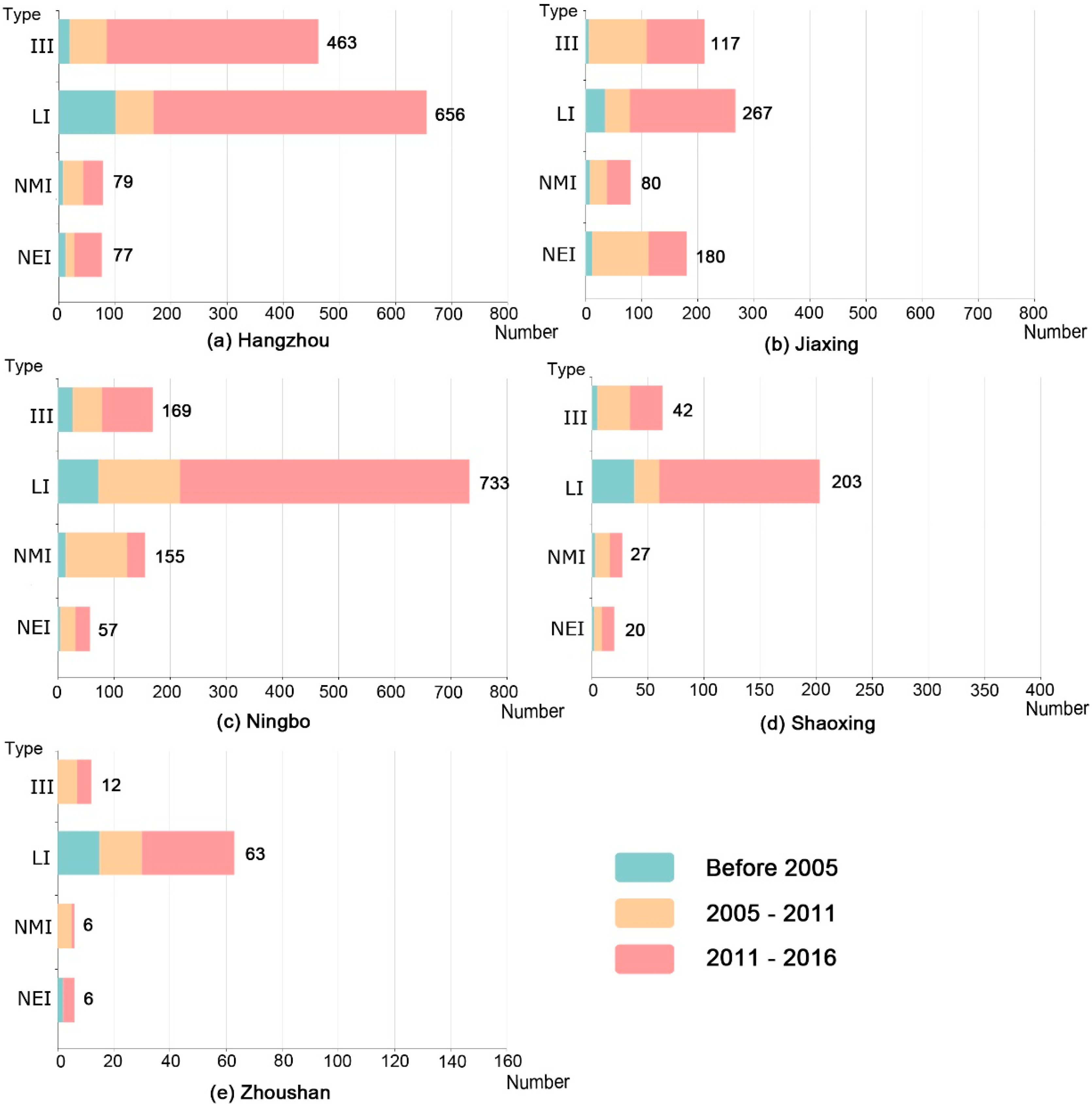
4.3. Growth of Industrial Regions at the City Level

The changes in both traditional industry and new industry varied at the city level (Figure 4 and Figure 5). Overall, during the entire period, traditional industries were the main types present in cities within the MHBR (Figure 4). TPAM exhibited the most dramatic growth, which mainly occurred in Hangzhou, Jiaxing and Shaoxing, with the enterprise number reaching 3872, 5178, and 2707, respectively, in 2016. UEM experienced the second largest increases in the above three cities, with the enterprise number reaching 2660, 1668, and 709, respectively, in 2016. In Ningbo, UEM achieved the highest enterprises number, with a value of 4167 in 2016. TPAM and ECMM were also dominant industrial types in Ningbo, with enterprise numbers reaching 2741 and 2378, respectively, in 2016. Meanwhile, MM1 and NMPM had considerable values in Ningbo, with enterprise numbers of 1434 and 1381, respectively, in 2016. In Zhoushan, UEM had a relatively large size, followed by FM, transportation equipment manufacturing (TEM) and NMPM.
However, decreases in the growth rates of most traditional industries in each city were observed (Table 3). For instance, in Hangzhou, the growth rate of paper manufacturing (PM1) during the period 2011–2016 reduced by approximately four-fold compared with the former period. The growth rate of petrochemical manufacturing (PM2) dropped from 21.5% to 10.9%. Additionally, decreases in UEM, TPAM, FRPM, and MM1 were observed. In Jiaxing, the growth of medical manufacturing (MM2), NMPM and FM exhibited slight decreases, whereas the growth of TPAM, UEM, MM1 and PM1 underwent a sharp drop between the two time periods. In Shaoxing, slight increases in the growth rates of TPAM, PM2, MM2, ECMM, and FM were observed; however, the growth rates of UEM, PM1, MM1 and FRPM dropped between the two time periods. In Ningbo, the growth rates of all the traditional industries, particularly UEM, TPAM, ECMM, and MM1, declined in the latter time period. As in Ningbo, the growth rates of all the traditional industries in Zhoushan exhibited clear declines between the two time periods.
In terms of four new industries, as shown in Table 3 and Figure 5, we found that III mainly grew in Hangzhou, with the enterprise number achieving 463 in 2016 and the growth rate increasing from 55.0% to 87.7% between the two time periods. The LI mainly grew in Ningbo and Hangzhou, achieving 733 enterprises and 656 enterprises, respectively, in 2016. The growth rates of LI of the two cities also exhibited increases, particularly in Hangzhou, with the value increasing five-fold. NEI was found to grow with a relatively high growth rate in Jiaxing during the period 2005–2011 and reached 180 enterprises in 2016. For NMI, Ningbo had the largest enterprise number (155), followed by Jiaxing and Hangzhou.

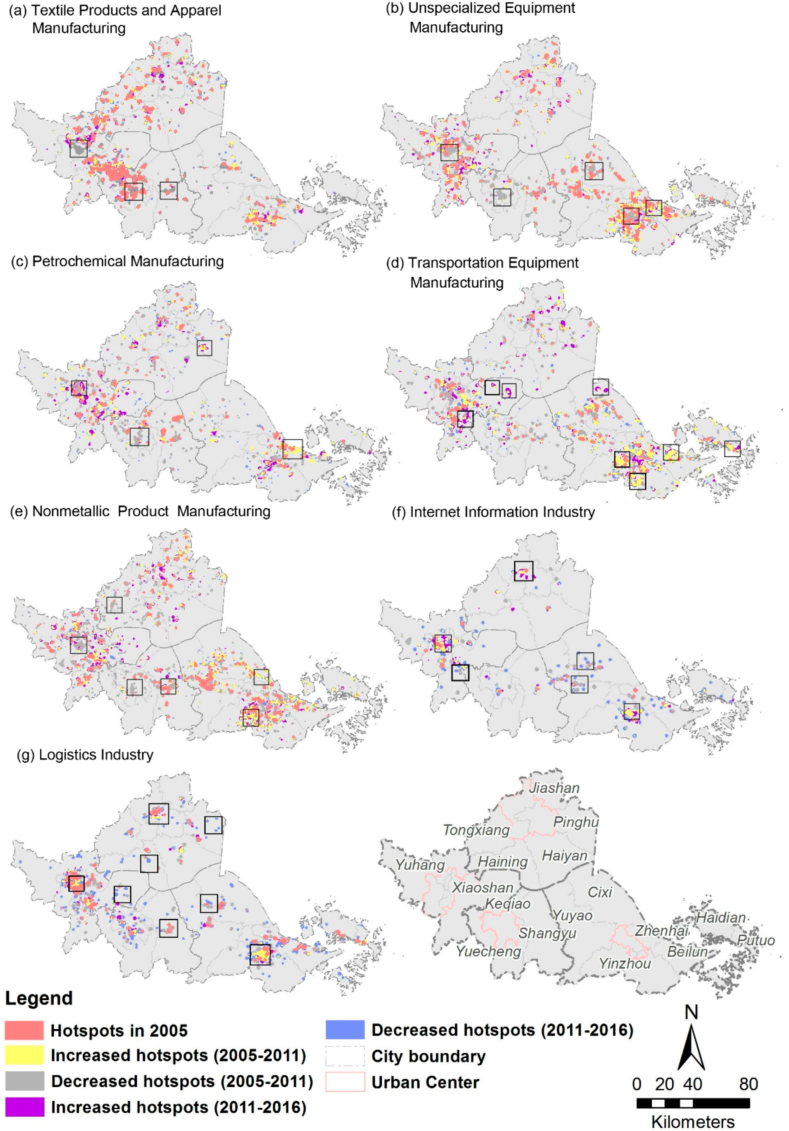
4.4. Concentration and Patterns of Industrial Activities

The hotspots map can be applied to analyze and monitor the development of industrial spaces as well as the change patterns. Through the use of local spatial autocorrelation based on a kernel density estimator, the hotspots detected were in accord with the clustering status of the industrial POIs (Figure 6e,f).
The changes in hotspot area at the city level were calculated (Table 4). In general, it can be observed that the hotspots area increased by 131.25 km2 and 56.75 km2, respectively, in Hangzhou and Jiaxing, whereas Shaoxing showed a continued decrease with an area of 224 km2 during the entire period. In Ningbo and Zhoushan, the hotspots areas increased in the first study period and decreased afterwards.
Combined with historical Google Earth images, we further found the coexistence of two industrial development modes: expansion and regeneration (Figure 7). The expansion here is characterized by the newly increased hotspot spreading out from the existing industrial hotspots [50]. In regeneration, a series of industrial enterprises are removed and may be converted into commercial or residential use [51]. A part (or all) of an industrial hotspot may vanish or shrink. That is, the hotspot area changes (increase or decrease) can reveal the two industrial development modes (expansion or regeneration) and further indicate the spatial reconfiguration of industrial enterprises.
The results of the industrial hotspots map in three times phases are depicted in Figure 8. The industrial hotspots in Ningbo experienced the greatest expansion, which mainly occurred at the outer ring of the city (e.g., Yinzhou, Beilun, Zhenhai, and Cixi) during the period 2005–2011 but shrank notably, particularly in Cixi and Yuyao, during the period 2011–2016. The hotspots in Hangzhou exhibited a relatively high expansion in the outer ring of the city (e.g., Yuhang and Xiaoshan) and exhibited an approximately equal area of shrinkage in the center city (e.g., Xiasha and Gongshu) between 2005 and 2011. Between 2011 and 2016, the hotspot expansion in Hangzhou showed a slight decrease, and the hotspots were mainly distributed in the center city (e.g., Shangcheng and Xihu). In Shaoxing, considerable hotspot shrinkage was observed, particularly during the period 2005–2011. Furthermore, we found that the expansion of hotspots in Jiaxing mainly occurred in the coastal areas and urban fringes, while the regeneration mainly occurred in the urban center, particularly during the period 2005–2011. In addition, the hotspot changes in Zhoushan were not notable and were mainly concentrated along the south of the mainland.
The spatiotemporal hotspot patterns of multiple industrial types were heterogeneous during the study period (Figure 9). The hotspots of several traditional industries exhibited evident shrinkages; for instance, the hotspots of TPAM, UEM, PM2, and NMPM experienced relatively large decreases in Shaoxing as well as in the urban center of Hangzhou between 2005 and 2011 (Figure 9a–c,e). Hotspot expansions of traditional industries were also observed and were highly distributed in the urban periphery and coastal area. For example, the hotspots of UEM, PM2, and TEM increased remarkably, especially in the outer ring of Ningbo (e.g., Zhenhai, Beilun, and Yinzhou) and the outer ring of Hangzhou (e.g., Xiaoshan) during the first period (Figure 9b–d).
In terms of new industry, both LI and III tended to form clusters at the core urban center of Hangzhou and Ningbo (Figure 9f,g). The hotspots of III expanded in small and dispersed clusters from 2005 to 2011 and exhibited subsequent increases in the urban center afterwards. Decreases in hotspots were also observed in Cixi and Yuyao as well as rural areas of Yinzhou and Yuhang from 2011 to 2016. With respect to LI, the hotspots increased considerably in the urban center from 2005 to 2011. Additionally, we found a slight growth of hotspots that was dispersedly distributed in the rural areas of Yuhang, Pinghu, and Haining from 2005 to 2011, but most of them decreased during the period 2011–2016. These results suggest that on the one hand, new industries such as LI and III have gained huge popularity across the MHBR, but on the other hand, small and scattered enterprises may be easily be shifted out because of a lack of core competitiveness.

5. Discussion

5.1. Comparision of Traditional Industry with New Industry

In the last decade, traditional industries such as textile products and apparel manufacturing, unspecific equipment manufacturing, electrical machinery and component manufacturing were dominant throughout the MHBR. Known as the “Zhejiang Model”, these industries mostly originate from private enterprises, which comply with the rules of market-based resource allocation and production factors free combination [52]. Because of a flexible operating mechanism and rapid response to market change, these industries not only contribute considerable economic vitality and great profits to the local industry but also foster the formation of industry clusters [53].
Nevertheless, the growth rate of these traditional industries has slowed, while the growth rate of the Internet information industry and logistics industry has increased explosively. This finding is consistent with the Chinese national planning document “Industrial transition and upgrading layout (2011–2015)” [13]. The plan emphasizes the optimization of the industrial structure and promotes the information technology industry. In the next few years, traditional industries are likely to enter a fatigued and weak phase because of drawbacks such as a low threshold for an industrial starting point, simple technical level, and lack of technical innovation [54]. However, the Internet information industry has made huge progress since the turn of the 21st century [55]. In the MHBR, this industry has further reinvigorated the regional economy, particular in Hangzhou. One of the most important Internet companies, Alibaba, is located in Hangzhou, which has led to a boom in surrounding areas [56]. Additionally, the presence of this large company can greatly stimulate the development of the logistics industry [57], which is in accordance with our findings.

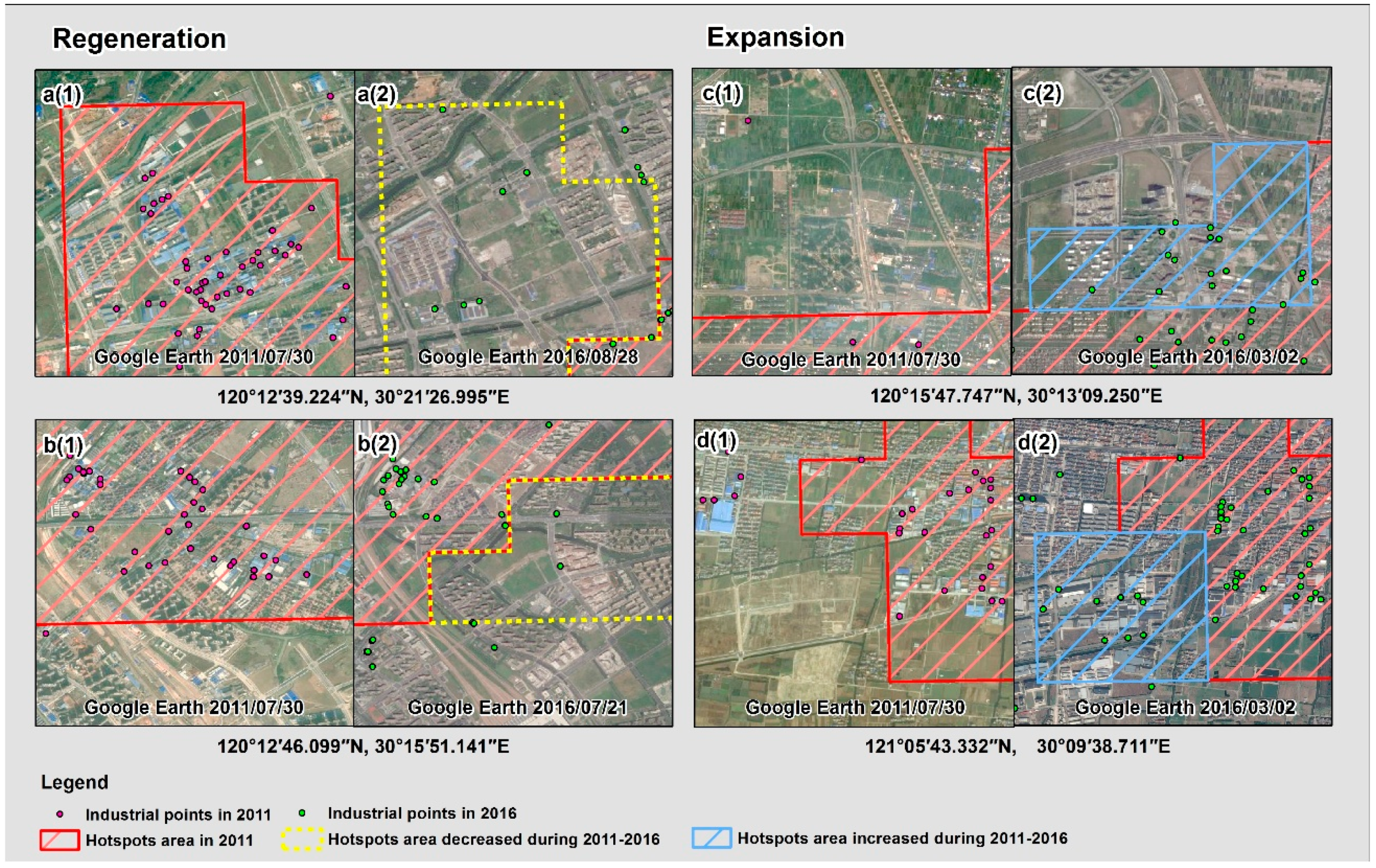
5.2. Spatiotemporal Changes of Industrial Hotspots

The hotspots analysis shows that the expansions of traditional industries such as transportation equipment manufacturing and petrochemical manufacturing tended to be distributed in the urban periphery and coastal area during the study period, whereas the new industries such as the Internet information industry mainly expanded in the urban center. These findings are supported by the industrial policies named “Powerful Zhejiang Province construction depending on industry planning (2011–2015)” [41] and “The development of industrial clusters area planning in Zhejiang Province (2011–2020)” [58]. Both of these policies encourage the centralization of industry to economic and technological development zones (ETDZ) and high-tech industry development zones (HIDZ) in order to achieve efficient and aggregative industrial development. To date, in the MHBR, there are a total of eighteen ETDZs, fourteen of which are located along the coastline of Hangzhou Bay (Figure 10). Additionally, there are four HIDZs developed inland. Manufacturers of large transportation equipment (e.g., automobiles, airplanes, high-speed railways) were generally developed in rural areas with abundant land, such as Xiaoshan Coastal ETDZ and Ningbo ETDZ.
Hotspot shrinkages of traditional industries such as textile products and apparel manufacturing, non-metallic product manufacturing, and metallurgical manufacturing were also found (Figure 9); thus, a series of industrial enterprises were eliminated for regeneration. The explanation can be supported by official announcements, “the suggestion of accelerating the project of ‘vacating cage to change birds’ to promote industrial transformation and upgrading” [59]. The project of “vacating cage to change birds”, means that due to the limitation of land resources and environmental issues, the region moves out or eliminates the low-end industry, and introduces high-tech industry, thus completing industrial reconfiguration and upgrading. This demonstrates the ability to accelerate the elimination of marginal and small-scale industrial enterprises and encourage dispersed enterprises to be arranged into ETDZs.

5.3. Methodology Assessment

In this study, we utilized industrial POIs to monitor multiple industrial uses at the urban agglomeration scale based on the integration of NLP and GIS techniques. The spatiotemporal pattern of ILU is well reflected. Our approach has several advantages. First, the industrial POIs used in our study are free and accessible. These POIs will also be updated at regular intervals, which implies that industrial use changes can be continuously monitored by tracking the dataset updates in the future. Second, making full use of the text information of industrial POIs, the NLP method can be considered a faster and more effective way to identify industrial land use, especially for large metropolitan areas, than traditional industrial land use surveys. Finally, unlike other studies that lack a deep exploration of spatiotemporal patterns, our study provides a comprehensive and detailed perspective on where each industrial use is located, where it is migrating and how the hotspots are spreading at a detailed level.
However, several limitations should be noted. For instance, the names of several enterprises may not reflect their social function, which would make difficult to determine the corresponding keyword related to a certain industrial use, leading to misidentification. Also, as there is no official industrial corpus database that clearly defines the relationship between industrial use and keywords; Thus, establishing such a corpus database manually is still needed. Furthermore, although the hotspots detection is capable of detecting industrial expansion and regeneration, the changed area should be accurately quantified by combining industrial POIs with remote sensing data in future work. Additionally, as a good measure of economic impact, the number of employees of industrial enterprises is not considered in this study, future work can integrate this data with industrial POIs for thorough research.

5.4. Sustainable Industrial Development: Policy Implications

Based on our findings and requirements of the government, targeted suggestions are provided for future sustainable industrial development in the MHBR.
First, Zhejiang central government should enhance the industrial macroscopic plan across MHBR. Because of the administration division and lack of scientifically-based layout at the MHBR level, redundant industrial land construction and vicious competition may occur between cities [35]. The local government of each city, must coordinate its prefecture-level plan with the overall planning of MHBR. Based on their industrial development advantages, scientifically-based plans must be included and implemented strictly.
Second, we suggest that targeted industrial land strategies should be formulated both in urban center and suburban region. The central urban areas should enhance the renewal of inefficient industrial land and encourage the development of services and high-tech industries. The projects, such as ‘’space exchange”, “revitalize the stock” should be comprehensively carried out. The suburbs should focus on optimizing industrial land layout, accelerating isolated enterprises to industrial functional zones or ETDZs, as well as continue to promote the upgrading of industrial structure from labor-intensive manufacturing to knowledge-intensive and high-tech manufacturing.
Third, the MHBR should strengthen scientific and technological investments, enhance independent innovation, and focus on environmentally-friendly and sustainable development. Our findings showed traditional industries such as petrochemical manufacturing, transportation equipment manufacturing were located in the coastal area. Sun et al. (2016) reported high-level environmental risks occurred in some coastal ETDZs [60]. Therefore, local government should improve the standards relating to environmental access and pollutant discharge, and restrict the excessive growth of low technology, high energy consumption, and high pollution emissions in manufacturing industries. The comprehensive sustainable evaluation system should be carried out to determine whether the enterprises reach the standards, and the enterprises performance should be in supervision and examined regularly.

6. Conclusions

The emergence of geospatial big data has shown powerful potential to track industrial activities. Industrial POIs were applied in our study. We established a new and comprehensive framework to quantify the ILU dynamic changes from 2005 to 2016 across the MHBR by integrating the NLP method and GIS analysis. With the help of the NLP method, ILU was elucidated. The two-step approach that combined statistical analysis and hotspots detection enabled us to gain an in-depth understanding of how the size of different ILU has changed, and where different ILU have expanded or regenerated.
The results revealed that traditional industries such as textile products and apparel manufacturing, unspecific equipment manufacturing, and electrical machinery and component manufacturing were the dominant types across the MHBR, with the enterprise number reaching 14,543, 9412, and 4374, respectively, in 2016. Compared with the period of 2005–2011 with 2011–2016, the growth rates of most traditional industries slowed in the latter period, nevertheless, the growth rates of new industries, including Internet information industry and logistics industry increased sharply in 2011–2016. The Internet information industry experienced remarkable growth, particularly in Hangzhou, with the growth rate increasing from 55.0% to 87.7% between the two time periods. The logistics industry increased considerably, particularly in Ningbo, with the growth rate increasing from 33.6% to 47.6%. Meanwhile, factories associated with traditional industry, such as transportation equipment manufacturing and petrochemical manufacturing plants, tended to be located in the coastal or rural ETDZs, whereas the Internet information industry was mainly located in the urban center. In addition, hotspot area shrinkages of traditional industries such as textile products and apparel manufacturing were observed. These spatiotemporal dynamics of industry further illustrate that the MHBR has been in a stage of economic transition from traditional labor-intensive manufacturing to advanced and high-technology manufacturing.
Quantifying the spatiotemporal patterns of industrial land uses is a basic step toward understanding the dynamics of industry. Our findings provide a detailed spatial view of multiple industrial use types. These findings can provide a valuable reference and aid government managers in supervising the industrial enterprises development and the newly expanded or redeveloped industrial projects to achieve healthier and more sustainable industrial land utilization.
In future research works, several issues could be improved: (1) integrating remote sensing data and POIs to obtain parcel-based industrial land use data; (2) developing emerging hotspots analysis to obtain more detailed insights into industrial hotspots changes [61]; and (3) quantifying the industrial land expansion and regeneration in transitional China.

Author Contributions

L.H. and K.W. conceived and designed the experiments; J.Z. and J.D. were responsible for recruitment and follow-up of study participants; L.H. was responsible for data collection; L.H. and Y.W. carried out the analyses; L.H. drafted the manuscript, which was revised by Q.Z. (Qing Zheng), Q.Z. (Qiming Zheng), X.Z., M.G., A.S. and J.W. All authors read and approved the final manuscript.

Funding

This research was funded by National Natural Science Foundation of China (No. 41701171), and the Basic Public Welfare Research Program of Zhejiang Province (No. LGN18D010002).

Acknowledgments

The authors would like to thank the anonymous referees for the valuable comments that greatly improved this article.

Conflicts of Interest

The authors declare no conflict of interest.

Appendix A

Table A1. Confusion matrix of industrial land uses identification.
TPAMUEMPM1PM2MM1MM2NMPMTEMCMMFMECMMCEPMFRPMIIILINMINEIOMMUA
TPAM480010011010000000092.31%
UEM042031101101000010279.25%
PM1004901000010000010290.74%
PM2120460010001000000286.79%
MM1010049000001000000390.74%
MM2000014900100000000194.23%
NMPM101000430800000000081.13%
TEM021100043004100000082.69%
CMM001000005000000000294.34%
FM010000000490000000490.74%
ECMM010020000047000000290.38%
CEPM000000000074401100280.00%
FRPM000110000000460000488.46%
III000100100001047100190.38%
LI000010112000004400384.62%
NMI111000003100000470087.04%
NEI110000001000000048290.57%
OMM230210010000120004076.92%
PA88.89%77.78%92.45%83.64%85.96%98.00%91.49%91.49%75.76%94.23%77.05%95.65%97.87%94.00%95.65%95.92%100.00%57.14%87.29%
Note: UA: user’s accuracy; PA: producer’s accuracy.

References

  1. Gao, J.; Dennis, Y.; Chen, W.; Chen, J. Economic Transition and urban Land Expansion in Provincial China. Habitat Int. 2014, 44, 461–473. [Google Scholar] [CrossRef]
  2. Wing, K.; Chan, K.W. Fundamentals of China’s Urbanization and Policy. China Rev. 2016, 10, 63–93. [Google Scholar]
  3. Liu, Y.; Fang, F.; Li, Y. Key Issues of Land Use in China and Implications for Policy Making. Land Use Policy 2014, 40, 6–12. [Google Scholar] [CrossRef]
  4. Tu, F.; Yu, X.; Ruan, J. Industrial Land Use Efficiency under Government Intervention: Evidence from Hangzhou, China. Habitat Int. 2014, 43, 1–10. [Google Scholar] [CrossRef]
  5. Yang, B.D.; Lv, J.; Yang, Y.J.; Chen, F.; Liu, G.J. Evolution of Industrial Land Location in Xuzhou City since Chinese Reform and Opening-up. Procedia Eng. 2017, 198, 1137–1148. [Google Scholar] [CrossRef]
  6. National Bureau of Statistics. China’s Urban Construction Statistical Yearbook-2014; China Statistics Press: Beijing, China, 2014; pp. 50–51. (In Chinese)
  7. Chen, T.; Chang, Q.; Liu, J.; Clevers, J.G.P.W.; Kooistra, L. Identification of Soil Heavy Metal Sources and Improvement in Spatial Mapping Based on Soil Spectral Information: A Case Study in Northwest China. Sci. Total Environ. 2016, 565, 155–164. [Google Scholar] [CrossRef] [PubMed]
  8. Jiang, L.; Bai, L. Spatio-Temporal Characteristics of Urban Air Pollutions and Their Causal Relationships: Evidence from Beijing and Its Neighboring Cities. Sci. Rep. 2018, 8, 1–12. [Google Scholar] [CrossRef] [PubMed]
  9. Chen, Z.; Kahn, M.E.; Liu, Y.; Wang, Z. The Consequences of Spatially Differentiated Water Pollution Regulation in China. J. Environ. Econ. Manag. 2018, 88, 468–485. [Google Scholar] [CrossRef]
  10. Wei, B.; Yang, L. A Review of Heavy Metal Contaminations in Urban Soils, Urban Road Dusts and Agricultural Soils from China. Microchem. J. 2010, 94, 99–107. [Google Scholar] [CrossRef]
  11. Wei, Y.H.D.; Liefner, I. Globalization, Industrial Restructuring, and Regional Development in China. Appl. Geogr. 2012, 32, 102–105. [Google Scholar] [CrossRef]
  12. National Development and Reform Commission. National New Urbanization Plan (2014–2020). Available online: http://ghs.ndrc.gov.cn/zttp/xxczhjs/ghzc/201605/t20160505_800839.html (accessed on 5 May 2016). (In Chinese)
  13. The Central People’s Government of the People’s Republic of China. Circular of the State Council on the Issuance of the Plan for Industrial Transformation and Upgrading (2011–2015). Available online: http://www.gov.cn/zwgk/2012-01/18/content_2047619.htm (accessed on 18 January 2012). (In Chinese)
  14. Ministry of Industry and Information Technology of the People’s Republic of China. Circular of the State Council on the Issuance of Manufacturing 2025 in China. Available online: http://www.miit.gov.cn/n973401/n1234620/n1234622/c4409653/content.html (accessed on 19 May 2015). (In Chinese)
  15. Ministry of Industry and Information Technology of the People’s Republic of China. Midterm Evaluation Report of the Plan for Industrial Transformation and Upgrading (2011–2015). Available online: http://www.miit.gov.cn/n1146295/n1652858/n1652930/n3757016/c3762448/content.html (accessed on 10 Februray 2014). (In Chinese)
  16. Fang, C.; Yu, D. Urban Agglomeration: An Evolving Concept of an Emerging Phenomenon. Landsc. Urban Plan. 2017, 162, 126–136. [Google Scholar] [CrossRef]
  17. Gao, Y.; Ma, Y. What is Absent from the Current Monitoring: Idleness of Rural Industrial Land in Suburban Shanghai. Habitat Int. 2015, 49, 138–147. [Google Scholar] [CrossRef]
  18. Huang, Z.; He, C.; Wei, Y.H.D. A Comparative Study of Land Efficiency of Electronics Firms Located Within and Outside Development Zones in Shanghai. Habitat Int. 2016, 56, 63–73. [Google Scholar] [CrossRef]
  19. Shi, Y.; Fan, W.; Pu, S. Comparative Analysis of Scale, Structure and Benefits of Metropolitan Industrial Land in China. Tongji Univ. Soc. Sci. 2010, 21, 26–31. (In Chinese) [Google Scholar]
  20. Deng, P.D.; Jefferson, G.H. Explaining Spatial Convergence of China’s Industrial Productivity. Oxf. Bull. Econ. Stat. 2011, 73, 818–832. [Google Scholar] [CrossRef]
  21. Zheng, Q.; Wang, K.; Huang, L.; Zheng, Q.; Abubakar, G.A. Monitoring the Different Types of Urban Construction Land Expansion (UCLE) in China’s Port City: A Case Study of Ningbo’s Central City. Sustainability 2017, 9, 2374. [Google Scholar] [CrossRef]
  22. Liang, Y.; Wang, F.; Li, G.; Jiang, H. Present Condition and Thoughts on Cadastral Information Service Policy. Shandong Land Resour. 2014, 30, 94–96. [Google Scholar]
  23. Zheng, X.; Wu, B.; Weston, M.V.; Zhang, J.; Gan, M.; Zhu, J.; Deng, J.; Wang, K.; Teng, L. Rural Settlement Subdivision by Using Landscape Metrics as Spatial Contextual Information. Remote Sens. 2017, 9, 486. [Google Scholar] [CrossRef]
  24. Blaschke, T. Object Based Image Analysis for Remote Sensing. ISPRS J. Photogramm. Remote Sens. 2010, 65, 2–16. [Google Scholar] [CrossRef]
  25. Berger, C.; Voltersen, M.; Hese, O.; Walde, I.; Schmullius, C. Robust Extraction of Urban Land Cover Information from HSR Multi-Spectral and LiDAR Data. IEEE J. Sel. Top. Appl. Earth Obs. Remote Sens. 2013, 6, 2196–2211. [Google Scholar] [CrossRef]
  26. Voltersen, M.; Berger, C.; Hese, S.; Schmullius, C. Object-Based Land Cover Mapping and Comprehensive Feature Calculation for an Automated Derivation of Urban Structure Types at Block Level. Remote Sens. Environ. 2014, 154, 192–201. [Google Scholar] [CrossRef]
  27. Comber, A.J.; Brunsdon, C.F.; Farmer, C.J.Q. Community Detection in Spatial Networks: Inferring Land Use from a Planar Graph of Land Cover Objects. Int. J. Appl. Earth Obs. Geoinf. 2012, 18, 274–282. [Google Scholar] [CrossRef]
  28. Hu, T.; Yang, J.; Li, X.; Gong, P. Mapping Urban Land Use by Using Landsat Images and Open Social Data. Remote Sens. 2016, 8, 151. [Google Scholar] [CrossRef]
  29. Chen, Y.; Liu, X.; Li, X.; Liu, X.; Yao, Y.; Hu, G.; Xu, X.; Pei, F. Delineating Urban Functional Areas with Building-Level Social Media Data: A Dynamic Time Warping (DTW) Distance Based K-Medoids Method. Landsc. Urban Plan. 2017, 160, 48–60. [Google Scholar] [CrossRef]
  30. Jiang, S.; Alves, A.; Rodrigues, F.; Ferreira, J.; Pereira, F.C. Mining Point-of-Interest Data from Social Networks for Urban Land Use Classification and Disaggregation. Comput. Environ. Urban Syst. 2015, 53, 36–46. [Google Scholar] [CrossRef]
  31. Yao, Y.; Li, X.; Liu, X.; Liu, P.; Liang, Z.; Zhang, J.; Mai, K. Sensing Spatial Distribution of Urban Land Use by Integrating Points-of-Interest and Google Word2Vec Model. Int. J. Geogr. Inf. Sci. 2016, 31, 825–848. [Google Scholar] [CrossRef]
  32. Zhang, X.; Du, S.; Wang, Q. Hierarchical Semantic Cognition for Urban Functional Zones with VHR Satellite Images and POI Data. ISPRS J. Photogramm. Remote Sens. 2017, 132, 170–184. [Google Scholar] [CrossRef]
  33. Yuan, J.; Zheng, Y.; Xie, X. Discovering Regions of Different Functions in a City Using Human Mobility and POIs. In Proceedings of the 18th ACM SIGKDD International Conference on Knowledge Discovery and Data Mining, Beijing, China, 12–16 August 2012; pp. 186–194. [Google Scholar]
  34. Ningbo-Zhoushan Port. Ningbo-Zhoushan Port Overview. Available online: http://www.portnbzs.com.cn/Introduction/overview (accessed on 1 Juanary 2006). (In Chinese).
  35. Zhou, D.; Xu, J.; Wang, L.; Lin, Z. Assessing Urbanization Quality Using Structure and Function Analyses: A Case Study of the Urban Agglomeration Around Hangzhou Bay (UAHB), China. Habitat Int. 2015, 49, 165–176. [Google Scholar] [CrossRef]
  36. Zhejiang Provincial Development and Reform Commission. Zhejiang Zhoushan Islands New Area Development Plan. Available online: http://www.zjdpc.gov.cn/art/2013/1/24/art_719_493202.html (accessed on 17 Juanary 2013). (In Chinese)
  37. National Bureau of Statstics. Zhejiang Statistical Yearbook-2017; China Statistics Press: Beijing, China, 2017. (In Chinese)
  38. Tang, G.; Xu, W.; Wang, S. A study on the Geographic Distribution Features and the Performance and the Forming Mechanism for the Zhejiang Regional Mass Economy. Hum. Geogr. 2003, 4, 53–59. (In Chinese) [Google Scholar]
  39. Shahtahmassebi, A.R.; Wu, C.; Blackburn, G.A.; Zheng, Q.; Huang, L.; Shortridge, A.; Shahtahmassebi, G.; Jiang, R.; He, S.; Wang, K.; et al. How do Modern Transportation Projects Impact on Development of Impervious Surfaces via New Urban Area and Urban Intensification? Evidence from Hangzhou Bay Bridge, China. Land Use Policy 2018, 77, 479–497. [Google Scholar] [CrossRef]
  40. Zhejiang People’s Government. Interpretation of the Plan for the Spatial Development of the Urban Agglomeration in the Hangzhou Bay in Zhejiang Province. Policy Outlook 2004, 1, 5–7. [Google Scholar]
  41. Zhejiang People’s Government. The Plan for Powerful Zhejiang Province Construction Depending on Industry. Available online: http://www.zj.gov.cn/art/2012/5/15/art_12460_121053.html (accessed on 15 May 2012). (In Chinese)
  42. Sun, S.; Luo, C.; Chen, J. A Review of Natural Language Processing Techniques for Opinion Mining Systems. Inf. Fusion 2017, 36, 10–25. [Google Scholar] [CrossRef]
  43. Yu, W.; Ai, T.; Yang, M.; Liu, J. Detecting “Hot Spots” of Facility POIs Based on Kernel Density Estimation and Spatial Autocorrelation Technique. Geomat. Inf. Sci. Wuhan Univ. 2016, 41, 221–226. [Google Scholar]
  44. Liu, Y.; Zeng, C.; Cui, H.; Song, Y. Sustainable Land Urbanization and Ecological Carrying Capacity: A Spatially Explicit Perspective. Sustainability 2018, 10, 3070. [Google Scholar] [CrossRef]
  45. Getis, A.; Ord, J.K. The Analysis of Spatial Association by Use of Distance Statistics. Geogr. Anal. 1992, 24, 189–206. [Google Scholar] [CrossRef]
  46. Ord, J.K.; Getis, A. Local Spatial Autocorrelation Statistics: Distributional Issues and an Application. Geogr. Anal. 1995, 27, 286–306. [Google Scholar] [CrossRef]
  47. Chance Scott, M.; Sen Roy, S.; Prasad, S. Spatial Patterns of Off-the-System Traffic Crashes in Miami–Dade County, Florida, during 2005–2010. Traffic Inj. Prev. 2016, 17, 729–735. [Google Scholar] [CrossRef] [PubMed]
  48. Ministry of Industry and Information Technology of the People’s Republic of China. The Twelfth Five-Year National Strategic New Industry Development Plan. Available online: http://www.miit.gov.cn/n1146295/n1146562/n1146650/c3074425/content.html (accessed on 9 July 2012). (In Chinese)
  49. Ministry of Finance of the People’s Republic of China. The Management of Special Funds for Strategic New Industry. Available online: http://jjs.mof.gov.cn/zhengwuxinxi/zhengcefagui/201301/t20130124_729883.html (accessed on 31 December 2012). (In Chinese)
  50. Porter, M. The Competitive Advantage of Nations. Harv. Bus. Rev. 1990, 68, 73–93. [Google Scholar]
  51. Roberts, P. The Evolution, Definition and Purpose of Urban Regeneration. Urban Regen. 2000, 2, 9–36. [Google Scholar]
  52. Han, F. Review of “Zhejiang Model”. J. Zhejiang Shuren Univ. 2009, 9, 70–74. [Google Scholar]
  53. Tang, G.; Xu, W.; Luo, M. Study on the Distribution Character of “Regional Mass Economy” and the Optimal Disposition of Industry in Zhejiang Province. Econ. Geogr. 2008, 23, 457–461. [Google Scholar]
  54. Li, J. Research on Development of Regional Massive Economic in Zhejiang Province. Master’s Thesis, Nanjing University of Aeronautics and Astronautics, Nanjing, China, June 2010. [Google Scholar]
  55. Kshetri, N. The Evolution of the Internet of Things Industry and Market in China: An Interplay of Institutions, Demands and Supply. Telecommun. Policy 2017, 41, 49–67. [Google Scholar] [CrossRef]
  56. Clifford Coonan. China’s Internet King Eyes World Domination. Available online: https://www.independent.co.uk/news/world/asia/chinas-internet-king-eyes-world-domination-2077573.html (accessed on 19 September 2010).
  57. Barreto, L.; Amaral, A.; Pereira, T. Industry 4.0 Implications in Logistics: An Overview. Procedia Manuf. 2017, 13, 1245–1252. [Google Scholar] [CrossRef]
  58. Zhejiang People’s Government. The Plan for the Development of Industrial Clusters Area in Zhejiang Province (2011–2020). Available online: http://www.zj.gov.cn/art/2010/10/13/art_12460_7548.html (accessed on 13 October 2010). (In Chinese)
  59. Zhejiang People’s Government. The Suggestion of Accelerating the Project of ‘Vacating Cage to Change Bird’ to Promote Industrial Transformation and Upgrading. Available online: http://www.zjdlr.gov.cn/art/2012/6/26/art_1228220_414.html (accessed on 26 June 2012). (In Chinese)
  60. Sun, T.; Lin, W.; Chen, G.; Guo, P.; Zeng, Y. Wetland Ecosystem Health Assessment through Integrating Remote Sensing and Inventory Data with an Assessment Model for the Hangzhou Bay, China. Sci. Total Environ. 2016, 566, 627–640. [Google Scholar] [CrossRef] [PubMed]
  61. Bunting, R.J.; Chang, O.Y.; Cowen, C.; Hankins, R.; Langston, S.; Warner, A.; Yang, X.; Louderback, E.R.; Roy, S.S. Spatial Patterns of Larceny and Aggravated Assault in Miami–Dade County, 2007–2015. Prof. Geogr. 2018, 70, 34–46. [Google Scholar] [CrossRef]
Figure 1. Location of the mega Hangzhou Bay region (MHBR).
Sustainability 10 03463 g001
Figure 2. Research flowchart.
Sustainability 10 03463 g002
Figure 3. Identification result of industrial land uses (2016).
Sustainability 10 03463 g003
Figure 4. The enterprises number of traditional industry from 2005 to 2016 in (a) Hangzhou, (b) Jiaxing, (c) Ningbo, (d) Shaoxing, and (e) Zhoushan.
Sustainability 10 03463 g004
Figure 5. The enterprises number of new industry in 2005, 2011, and 2016 in (a) Hangzhou, (b) Jiaxing, (c) Ningbo, (d) Shaoxing, and (e) Zhoushan.
Sustainability 10 03463 g005
Figure 6. Hotspots detection: (a) kernel density map; (b,c) partial views of kernel density map; (d) hotspots map based on kernel density estimator and Getis-Ord Gi* statistic; and (e,f) partial views of hotspots map.
Sustainability 10 03463 g006
Figure 7. Representative examples of (a,b) industrial regeneration and (c,d) industrial expansion process.
Sustainability 10 03463 g007
Figure 8. The spatiotemporal patterns of overall industrial hotspots: (a) hotspots dynamics between 2005 and 2011; (b) hotspots dynamics between 2011 and 2016.
Sustainability 10 03463 g008
Figure 9. Hotspots map of different industrial uses from 2005 to 2016: (a) textile products and apparel manufacturing; (b) unspecialized equipment manufacturing; (c) petrochemical manufacturing; (d) transportation equipment manufacturing; (e) nonmetallic product manufacturing; (f) Internet information industry; and (g) logistics industry.
Sustainability 10 03463 g009
Figure 10. The economic and technological development zones and high-tech industry development zones across MHBR.
Sustainability 10 03463 g010
Table 1. Industrial land uses classification system.
Industrial Land UsesDescription
1. Traditional IndustryTextile Products and Apparel Manufacturing (TPAM)This Industry includes preparation and spinning of fiber, weaving of fabric, and finishing of textiles. It also covers manufacturing of clothing (e.g., outerwear and underwear).
Unspecialized Equipment Manufacturing (UEM)This industry includes the manufacturing of equipment applied in more than one industry, such as the manufacturing of bearings, gear and transmission equipment; pump and compression equipment; metal-working equipment; packaging equipment; and other unspecialized accessories.
Paper Manufacturing (PM1)This industry includes the manufacturing of pulp and converted paper. The printing of paper products (e.g., newspapers, books and greeting cards) is also included.
Petrochemical Manufacturing (PM2)The industry includes chemical manufacturing, which involves transforming organic and inorganic raw materials via a chemical process for the formation of products. It also includes the transformation of crude petroleum into usable products.
Metallurgical Manufacturing (MM1)This industry includes the manufacturing of basic metals and fabricated metal products.
Medical Manufacturing (MM2)This industry includes the manufacturing of basic pharmaceutical products and pharmaceutical preparation. Additionally, it includes medicinal, chemical and botanical product manufacturing.
Non-metallic Product Manufacturing (NMPM)This industry includes the manufacturing of rubber and plastics products, glass and glass products, ceramic products, and other non-metallic products. Materials used in construction are excluded.
Transportation Equipment Manufacturing (TEM)This industry produces equipment for transporting people and goods, such as motor vehicles, aircraft, ships and boats, railway rolling stock and locomotives, and their accessories.
Construction Material Manufacturing (CMM)This industry includes the manufacturing of products used for construction, such as tiles and bricks, cement and plaster, dimension stone, wall materials and other materials.
Food Manufacturing (FM)This industry includes the production of different types of food: meat, fish, fruit and vegetables, oil, milk products, beverages and drinks. Additionally, the manufacturing of tobacco (e.g., cigarettes and cigars) is included.
Electrical Machinery and Component Manufacturing (ECMM)This industry includes the manufacturing of products that generate, distribute and use electrical power. Additionally, it includes the manufacturing of electrical lighting, signaling equipment and electrical household appliances.
Computer and Electronic Products Manufacturing (CEPM)This industry includes the manufacturing of computers, computer peripherals, communications equipment, and similar electronic products.
Furniture and Related Product Manufacturing (FRPM)This industry includes the manufacturing of furniture and related articles, such as mattresses, window blinds, cabinets and fixtures.
2. New IndustryInternet Information Industry (III)This industry specializes in cyber source collection and Internet information technology development, production, storage, transmission, and marketing for information commodity.
Logistics Industry (LI)This industry includes the planning, implementation and control of the transportation, reverse flow and storage of goods, services, and related information between the point of origin and the point of terminal.
New Material Industry (NMI)This industry includes the manufacturing of new materials that have applied new techniques or crafts during production, and have better performance or generate new functions, such as biomaterials, nanomaterials, and superconductor.
New Energy Industry (NEI)This industry includes the manufacturing of new energy, especially renewable energy, such as hydroelectric power, wind power, and solar power generation.
3. Other Miscellaneous Manufacturing Other Miscellaneous Manufacturing(OMM)This industry includes the manufacturing of a variety of products not contained in other classifications. Specifically, it consists of the manufacturing of sport and athletic goods, dolls and toys, jewelry and other accessories.
Table 2. The enterprises number, growth rate of industrial land uses at the mega Hangzhou Bay region (MHBR) level.
Industrial Land UsesNumber of Enterprises (Ratio: %)Rate of Growth (%)
2005201120162005–20112011–2016
1. Traditional industry
TPAM3616 (21.7)9825 (21.4)14543 (19.5)28.69.6
UEM2143 (12.8)6987 (15.2)9412 (12.6)37.76.9
PM1477 (2.9)1595 (3.5)2111 (2.8)39.16.5
PM2488 (2.9)892 (1.9)1167 (1.6)13.86.2
MM1759 (4.6)2563 (5.6)3115 (4.2)39.64.3
MM2170 (1.0)394 (0.9)758 (1.0)22.018.5
NMPM1010 (6.1)2497 (5.4)3205 (4.3)24.55.7
TEM314 (1.9)1116 (2.4)1544 (2.1)42.67.7
CMM141 (0.8)559 (1.2)1201 (1.6)49.423.0
FM694 (4.2)1194 (2.6)1693 (2.3)12.08.4
ECMM1111 (6.7)3400 (7.4)4374 (5.9)34.35.7
CEPM389 (2.3)1470 (3.2)1979 (2.7)46.36.9
FRPM356 (2.1)1302 (2.8)1757 (2.4)44.37.0
2. New industry
III57 (0.3)198 (0.4)803 (1.1)41.261.1
LI262 (1.6)555 (1.2)1922 (2.6)18.649.3
NMI33 (0.2)226 (0.5)347 (0.5)97.510.7
NEI33 (0.2)182 (0.4)340 (0.5)75.317.4
3. Other miscellaneous manufacturing
OMM4625 (27.7)10866 (23.7)24343 (32.6)22.524.8
Table 3. The annual growth rate of industrial land uses at the city level (%).
Industrial Land UsesHangzhouNingboJiaxingShaoxingZhoushan
ABABABABAB
1. Traditional industry
TPAM30.916.346.43.836.89.29.71035.6-
UEM32.012.948.03.543.49.89.17.787.90.7
PM138.29.555.13.337.17.714.47.639.6−0.7
PM221.510.924.24.214.35.30.53.226.27.8
MM129.56.947.21.657.48.411.35.8150−1.0
MM224.932.839.26.519.813.24.86.119.02.7
NMPM16.310.339.62.218.010.07.76.881.82.5
TEM25.913.674.63.922.416.09.07.052.87.5
CMM52.832.570.310.442.322.022.224.172.223.8
FM17.315.69.05.012.59.52.55.633.30.5
ECMM22.516.144.72.237.510.27.78.155.02.8
CEPM50.418.554.31.434.88.417.315.866.74.0
FRPM68.712.763.32.426.66.617.57.891.77.7
2. New industry
III5587.733.323.322.2147.126.744.6-14.3
LI10.957.633.647.621.047.69.647.716.722.0
NMI75.015.9129.85.262.522.172.213.8-4.0
NEI19.235.0112.516.8138.912.158.324.4-40.0
3. Other Miscellaneous Manufacturing
OMM25.148.12910.320.926.36.819.426.219.2
Note: A is the period of 2005–2011; B is the period of 2011–2016.
Table 4. The hotspots area changes at the city level (km2).
PeriodHangzhouNingboJiaxingShaoxingZhoushan
2005–201136.25272.5037.50−215.2511.75
2011–201695.00−211.7519.25−8.75−10.00
2005–2016131.2560.7556.75−224.001.75

