Sharing Integrated Spatial and Thematic Data: The CRISOLA Case for Malta and the European Project Plan4all Process

Abstract
: Sharing data across diverse thematic disciplines is only the next step in a series of hard-fought efforts to ensure barrier-free data availability. The Plan4all project is one such effort, focusing on the interoperability and harmonisation of spatial planning data as based on the INSPIRE protocols. The aims are to support holistic planning and the development of a European network of public and private actors as well as Spatial Data Infrastructure (SDI). The Plan4all and INSPIRE standards enable planners to publish and share spatial planning data. The Malta case tackled the wider scenario for sharing of data, through the investigation of the availability, transformation and dissemination of data using geoportals. The study is brought to the fore with an analysis of the approaches taken to ensure that data in the physical and social domains are harmonised in an internationally-established process. Through an analysis of the criminological theme, the Plan4all process is integrated with the social and land use themes as identified in the CRISOLA model. The process serves as a basis for the need to view sharing as one part of the datacycle rather than an end in itself: without a solid protocol the foundations have been laid for the implementation of the datasets in the social and crime domains.1. Introduction
Why analyse crime as a spatial theme and why should it be depicted through an online interactive tool? The process to investigate a social discipline employing high-end technology and in turn to disseminate it to the public has proven a decades-long effort which requires an understanding of criminology, spatial information systems and dissemination methodologies. This study investigates the different domains that need to be integrated in order to deliver an online interactive crime-mapping solution and delivers the process through a description of environmental criminology, the technologies employed in web-mapping as a tool to disseminate such information, the data model used to investigate the links between the different social domains, as well as describing the process employed to create web-maps in the Maltese Islands. Finally the different domains are brought together through an investigation of how the developments created within an EU project Plan4all will be employed to disseminate the crime data online.
1.1. The Environmental Criminology Scenario
Crime is an ideal scenario to integrate within a spatial construct as it is a multi-faceted domain encompassing the physical location of the offender and the offence, the spatial relationships between the offender and victim and the social thematic constructs as they evolve in physical space. The theory of urban ecology or environmental criminology grew from the work of the Chicago School of Sociology, with the main proponents being Shaw and McKay [1] and their 1930s′ theory of social disorganisation, which was based on the concept of human urban ecology [2]. Urban ecology posits that there is a positive correlation between crime, social issues and landuse [3], which theory has been further developed through Brantingham and Brantingham's 1994 concept of the physical and cognitive spaces within which environmental criminology operates [4] particularly the development that lead to the development of crime pattern theory that looks at both the established and changing nature of crime. Crime patterns can only happen due to the constructs that make them, inclusive of the location they occur in, and the sociological and psychological relationships which are shaped by the geographical context of both offender and offence [5]. The Malta socio-physico-crime CRISOLA research [6,7] based its study on this theoretical base as such studies emphasise the vitality of social landscapes and how they impinge on or are impacted by the physical landscapes. The conceptual model is based on the investigation of the correlations between the CRIme, SOcial and LAnduse themes, herein embedded as the acronym CRISOLA.
Analysis of the social interactionism in an area enables successful implementation of crime preventive strategies [8,9]. The study also basis its analysis on Opportunity Theory which studies the way urban structures and landscapes offer opportunities for crime [10] and Routine Activities Theory which postulates that each offender and victim follow repeatable paths or routines that are delineated by the space they live in over time [11].
One particular organisation, the MAPS [12] programme (previously called the Crime Mapping Analysis Program) based its approach on the above and even splits its activities around 4 functions: (i) investigative or crime series analysis; (ii) operations research or resource allocation studies; (iii) applied research/problem solving; and (iv) discrete site analysis such as schools [13].
The crime discipline serves as a sound basis for the investigation of its use for data sharing and dissemination through the use of geoportals as it operates in a multi-domain scenario. The latter includes the physical location of the activity, the social context within which it operates and the informational aspect as a basic need for awareness-building on security and safety. As this function is still in its embryonic phase, this paper tackled the process required to process data to a spatial domain through the implementation of data gathering, analysis and dissemination protocols established under the European spatial data regulatory legislation called INSPIRE [14]. The study reviewed the potential for the employment of such protocols used in the physical domain with an aim to review whether it is possible to create a parallel process for the criminological domain.
2. The Case for Maltese Web-Mapping
2.1. Spatial Analysis and Its Impact on Social Research: The Criminological Approach
Crime analysis takes up different forms, from studying events by manually sticking pins on wall maps to identify crime locations, to the use of tabular data in spreadsheets and databases and eventually to the use of statistical tools and GIS, aided by theme-specific GIS modules in proprietary software that cater specifically for crime. Access to data is still a major issue, with access to sensitive crime-related data even more so. The 2011 online crimemap published by the UK police ( http://www.police.uk/) and that available on Malta since 2007 ( www.crimemalta.com) show point data and aggregated data respectively
Social-scientific research to date has depended on textual and tabular data that is rarely analysed in a spatio-temporal setting. The use of spatial and temporal analysis of crime data has enabled analysts to combine different resources stored in various formats into a coherent system. With GIS technology, multiple variable analyses is possible due to ‘its ability to compare multiple geographic factors and investigate geographic correlations’ and identify the root cause of a problem [15]. It also has the ability to unravel a complex issue that may be too difficult to investigate using conventional methods such as the wall-maps exercise where coloured pins identifying crime types were stuck to a wall making it too difficult to analyse as the number of crimes grew. GIS aids researchers to generate new knowledge through the use of cross-data analysis such as land zoning and offence location through the concept of layering. Better still, this analysis can be carried out in a time-series process to create a spatio-temporal output, effectively identifying trends and helping to recommend policy change. Although the development of these technologies has granted access to researchers to carry out comparative spatio-temporal analysis, caution must be taken to take up Pease's (2001) heed to understand the limitations of such systems and methodologies [16].
Further developments in the area of crime mapping show an increased application use by police departments and crime analysts, with interest in crimes by such major entities as the Home Office [17] (UK) and the National Institute of Justice in the US [18], Interpol [19], Europol [20], University of Sheffield [21], University of Huddersfield [22], Jill Dando Institute [23], the University of Liverpool [24] and the University of Malta [25]. These initiatives were based on an ad hoc process which lacked a system-wide set of protocols that would establish convergence between the datasets. The INSPIRE exercise proved timely to the realisation of the requirements and work required to process crime data in line with the other domains.
2.2. The CRISOLA Model
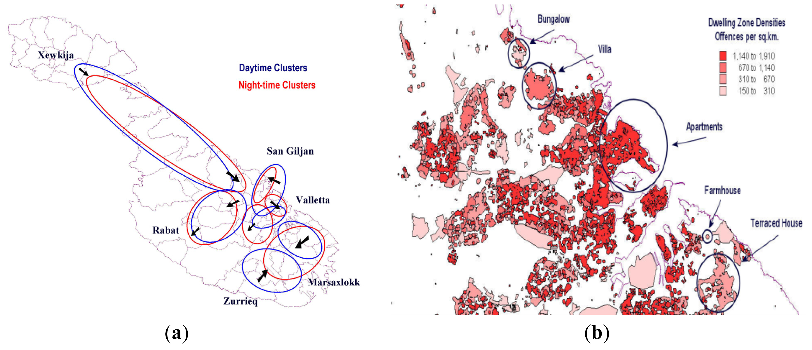
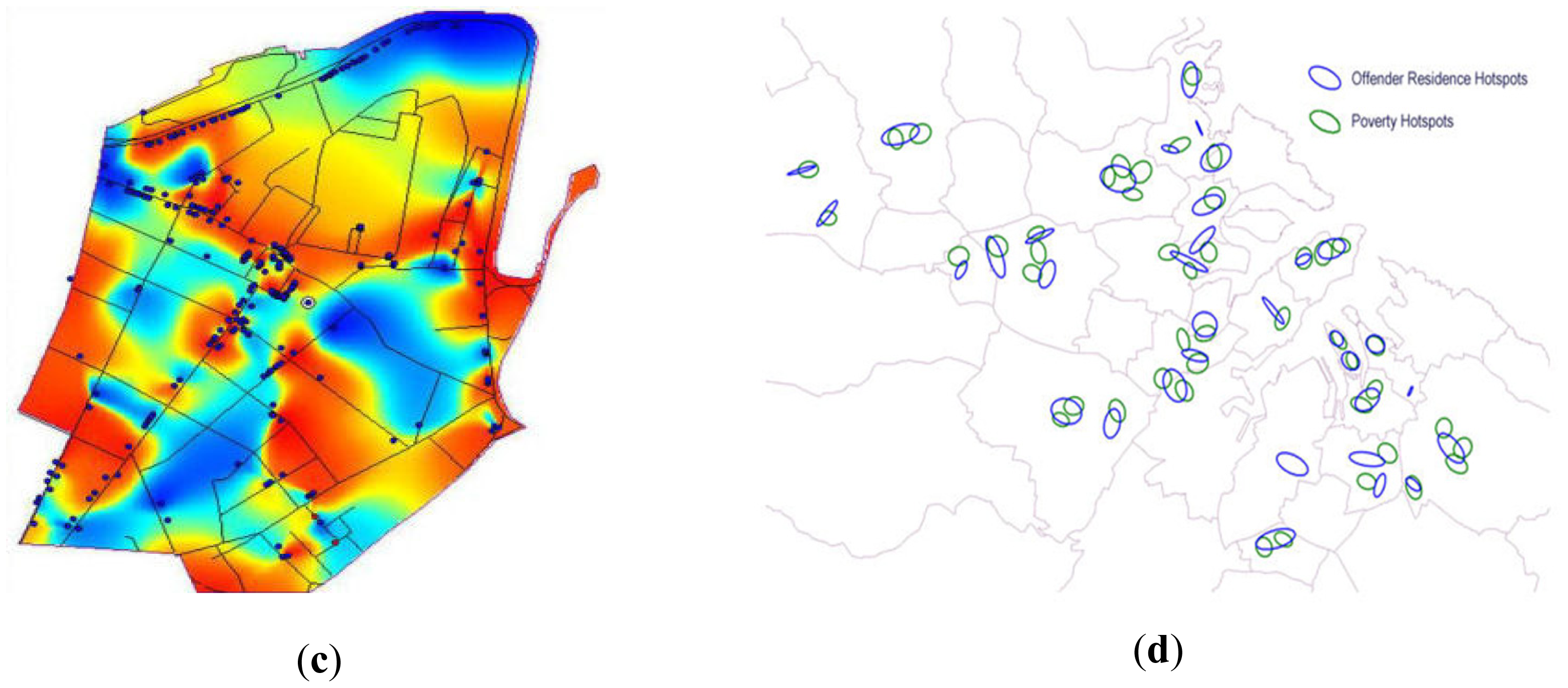
A conceptual model was created by Formosa [6] to enable an understanding of the complex Maltese data availability situation together with the spatial requirements for data within the different landscapes that are posited by the crime, social and physical worlds. The aim of the model is to identify the impacts of crime on social-capital and socio-cohesion, the impacts on security and safety and the impacts on spatial capital. The study highlighted the need to bring together each aspect and built a mindmap that helps set out a process to depict a basic and generic model on how crime, social and landuse issues interact together, which process also identified techniques and datasets that could be used in the identification and understanding of crime. The model lays the base for social scientists to identify the links between the various variables across the three domains, such as the correlations between location of offender residence and the areas of poverty (Figure 1d). Another aspect emanating from the model concerns the identification of policy changes that would be required should an area be depopulated and the subsequent dilapidation would result in an increase in offences as well as a migration of offenders to the area (Figure 1c).
Figure 1(a–d) depicts outputs from the CRISOLA model research carried out in Malta, which can be employed by policy-makers for their planning functions as based on the urban ecology theory. Figure 1a describes the differences between day-time and night-time crimes and how they migrate towards those areas of recreation during the night, whilst Figure 1b identifies the relationship between dwelling type and offence structure, particularly the high rates of offences occurring in apartment areas. Figure 1c identifies offence hotspots as they occur in an urban area whilst Figure 1d identifies the spatial relationships between areas where offenders live and their direct overlay on areas of poverty.
The CRISOLA model outlines criminal activity within the social and physical structures:
the crime characteristics through an analysis of offender and offence composition and the interactivity between them [10];
the social characteristics of an area through an analysis of its poverty/deprivation [26];
the physical characteristics of an area, particularly its land use, structural and zoning parameters [11].
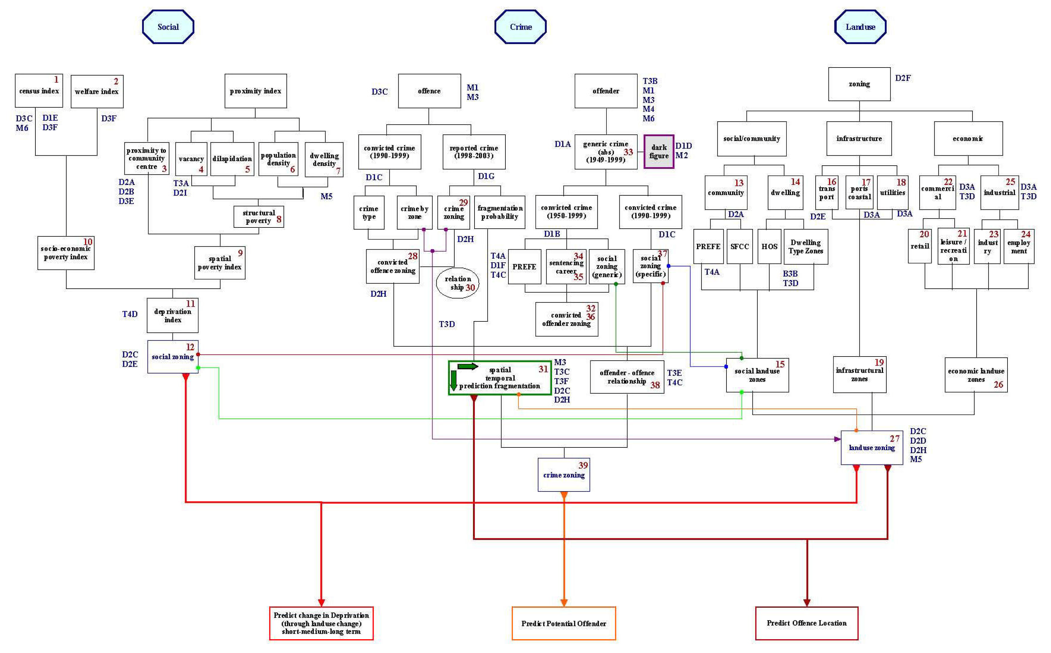
In order to identify the above structures, a three-phase model was created, with a basic first phase enabling a generic focus on the targets and impacts of each theme on the other two, following which a more detailed second phase was required to identify the interactivity between the three parameters. This is accomplished through the identification of datasets that may be used for analysis. Phase 2 (Figure 2) sought to identify those literature-related issues and integrate them within the model. It reviewed the different theories, datasets, spatio-temporal aspects, predictors and the main tenets that can be used in such a study on crime. Figure 2 outlines those themes and datasets that were identified as potential candidates for the study as well as marking the links between the datasets through connecting lines. Taking the model one step further to Phase 3, a series of statistical measures are listed within each dataset as required to investigate the correlations between the variables. The model does not attempt to solve all CRISOLA issues but depicts the potential future studies that can be attempted within an integrated framework that brings together those isolated datasets used in traditional methods as well as new data inputs from other technological domains.
Being a conceptual exercise, a mindmap exercise was carried out, which is a process that enables researchers to identify the themes and the related variables, as well as the potential links between the different themes and variables. Once the results are drafted, the sources and attributes of each dataset are listed in the relative sections of the model.
2.3. The Tools
The tools used in this study include CrimeStat, SPSS, MapInfo (Hotspot Mapping Extension), and Vertical Mapper. Methods and statistics included; spatial distribution, distance statistics, ‘Hot spot’ analysis routines and Interpolation statistics, particularly Moran's I, hot spot, NNA interpolation. Other techniques that have been developed which would aid the study include GI*, LISA methods, Kernel Density Estimation and the Geographically Weighted Regression (GWR). Note that each of these methods necessitates knowledge of the limitations in using that specific method which limitations are dependent on a number of factors. These include the sample size taken, the number of minimal points set as the threshold for identifying the least hotspot size, amongst others. In addition, NNH as well-as K-Means were employed in the CRISOLA study since they depicted their results through ellipsoids, which in effect can cover aggregated offence and offender areas based on the large number of points and ensure that privacy of the victim/offender is maintained. These outputs are better suited for the aggregated forms which can be disseminated online without compromising the safety of the exact victim location that the offence occurs in, thus reducing the potential for re-offending.
Major improvements in the analysis area have occurred during the last few years and tools have been developed that carry out statistical research in a spatial construct. These software include such examples as CrimeStat [27,28] now in version III. In addition, specialised tools have been developed by major software companies providing evidence that the commercial sector has seen ways to profit from “crime”. Tools in the private and public domain include ESRI products (Crime Extension) [29], MapInfo [30] (Hotspot Mapping Extension) [31], Vertical Mapper [32], and related products. In their study on Sheffield, Craglia et al. [33] used SAGE [34] and STAC [35] programmes. They used the software for the analysis of offence data, offender data as well as victim data. This has helped to develop a base for the study of crime through high-end software. Formosa [6,7] developed a Malta-based Crime spatial information system for various analytical processes inclusive of journey to crime, poverty-offender analysis, hotspot mapping and the relative index of spatial crime.
The above topics identify GIS as a complex technology that has come to age at a crucial time for crime-analysis, allowing the analysis of large datasets through its crime-mapping technique and enabling dissemination through web-mapping technology.
2.4. The Maltese Web-Maps
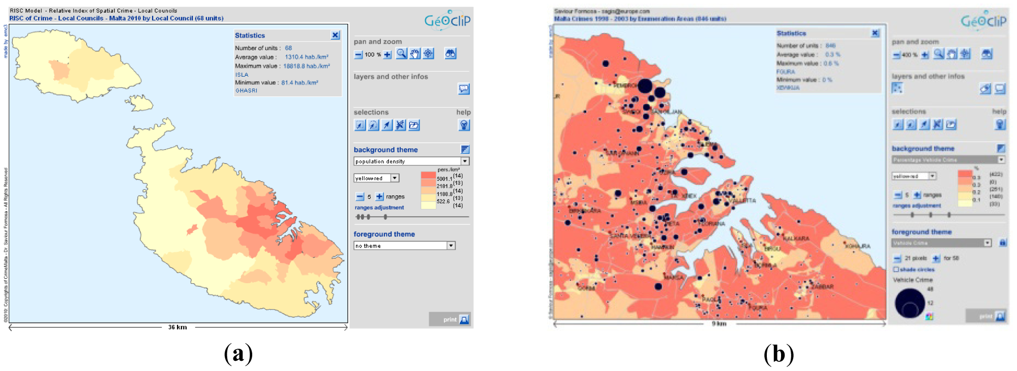
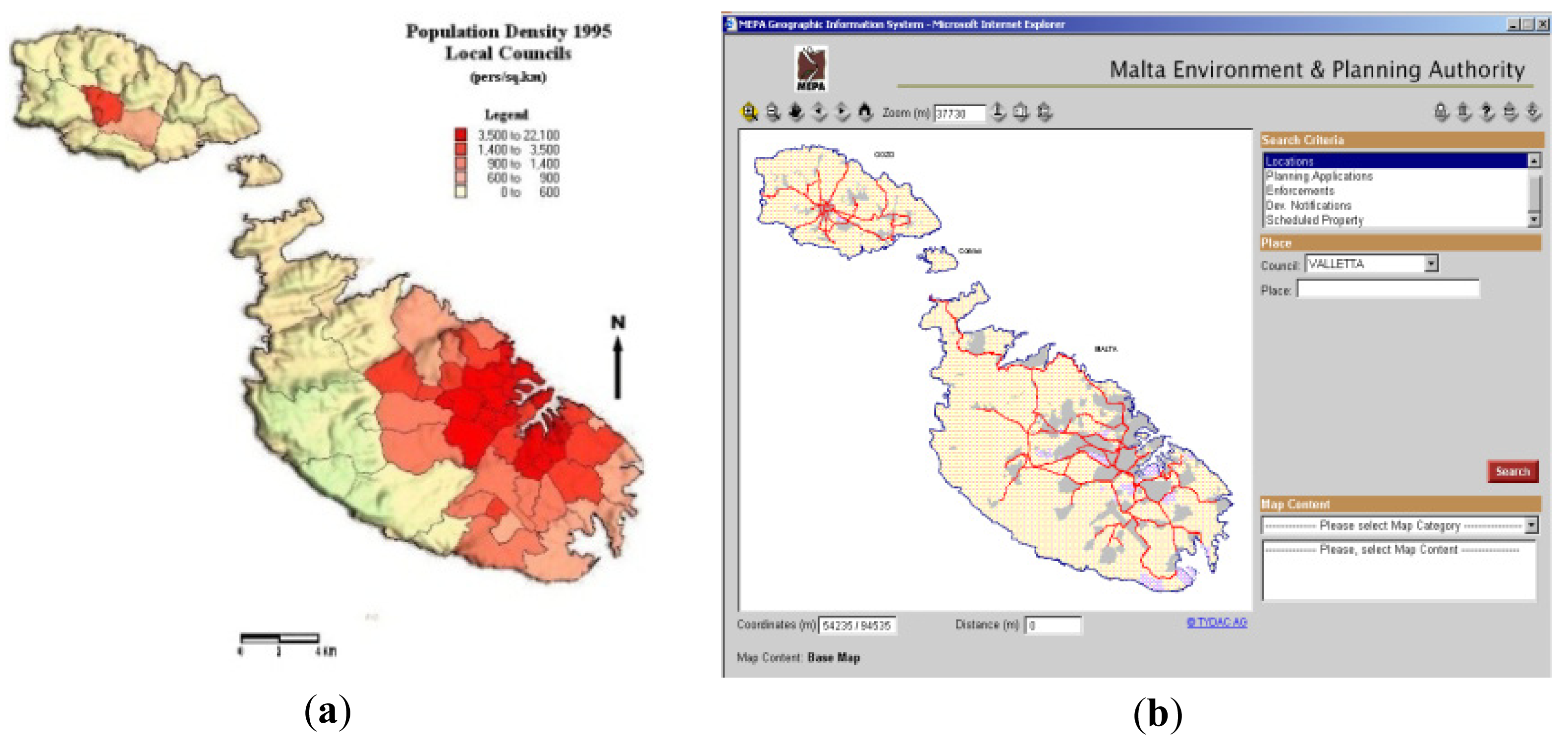
The first thematic Maltese webmap was created in 2000 as based on the mapping of the Census of Population and Housing data [36,37], which service was based on image-mapping and GIS-client technologies (Figure 3a depicts population density). A year later (2001) the Malta Planning Authority launched its development planning mapserver [38] which was based on MapInfo MapXSite [39] that however lacked extensive querying capabilities (Figure 3b depicts the querying interface). The next web-map employing interactive technology was published by the National Statistics Office depicting the Census of 2005 [40], which employed Geoclip [41] and MapInfo applications. The next process initiated through the creation of environmental GI data layers such as habitats maps, which was carried out as part of a process to enhance spatial information for the general public and the research community in line with the EU/EEA dataflow requirements [42]. This process was achieved through the implementation of the Aarhus Convention that ensures that environmental information is disseminated for free [43].
2.5. The Crime Spatial Outputs
Based on the above benchmarking exercise, the different options available for the criminological study were identified and a local crime-mapping site developed. The technology employed is based on a MapInfo mbx programme developed by emc3 [41], which uses standalone Flash (.swf) technology as its spatial carrier. Users can interact with the mapped data in a format they are already familiar with when browsing the internet. Simple help files are also available and guide the user on how to interact with the crime-map. Though not based on a geoserver structure, such a new approach is a major improvement from the early technologies of image-mapping and GIS-Client that required extensive downloading sessions. It is also an improvement as against a full map-server function that requires a remote and potentially heavy site [37]. Flash technology enables integration of the GI datasets and maps within a very small and simple flash file that can be conveyed easily over the web and even used on a standalone computer.
The prototype site created by the author encompasses a Web-GIS view with interaction on a number of variables such as police-reports crimes from 1998 to 2010, vehicle crime, serious and non-serious crime, amongst others. In terms of benchmarking, it is tagged as mid-range for its pre-prepared structure that at the same time allows extensive user interaction such as personalised map creation and outputting as against low-range image-maps and high-range fully-interactive services. Figure 4a,b depicts the Malta Crime Web-GIS created for this study ( www.crimemalta.com), with Figure 4a depicting the interface based on a Choropleth map of crimes in each locality and Figure 4b identifying both the RISC rates (crime per households in each area) and the absolute number of offences through a graduated map.
The decision to employ data at various aggregation levels as against point data was taken with awareness that the victim/offence locations are protected and a conscious decision was taken to depict the data at NUTS1_2 (national), NUTS3 (Island), NUTS4 (Districts), NUTS 5 (Localities and EAS (Enumeration Areas of 150 households). This aggregation process was carried out to avoid depicting very small areas as hotspots for crime and to avoid the ‘marketing’ of vulnerable areas to potential offenders as well as repercussions from the security and insurance industries.
2.6. The Plan4all Input: Hopes for Streamlining CRISOLA
The CRISOLA outputs have had a significant input into the understanding of a social theme using a spatial construct, but the model itself needs to be structured towards a more realistic web-map structure. To date it is still too crude and requires streamlining towards the requirements of the INSPIRE Directive [14,44]. The data is harvested in an unstructured way, no lineages are recorded within source agencies and only the researchers have attempted to structure the various sources through the CRISOLA model. Thus the need is felt to source protocols that have scientific and legal background. In effect, one project that has set the ball rolling for the next phase of spatial-social data interoperability for the CRISOLA outputs is the Plan4all project [45].
Plan4all is a European project running from May 2009 until October 2011 and co-financed by the eContentplus programme of the European Commission. Plan4all focuses on interoperability and harmonisation of spatial planning data in Europe to support holistic spatial planning activities. All planning tasks and processes must be solved comprehensively with input from various sources inclusive of the social themes. The diversity of data across the physical and social domains makes it necessary to make inputs interoperable because it allows the user to search data from different sources, view them, download them and use them with help of geoinformation technologies. Data harmonisation means that all member states use a common set of coordinate reference systems, data models, classification schemes, portrayal rules, etc. Interoperability is understood as providing access to spatial datasets through network services, independent from whether the existing dataset is actually changed (harmonised) or just transformed by a service for publication [46].
Why choose the Plan4all structure as a base for CRISOLA? The Plan4all metadata profile [47] states that one of its aims at making spatial plans comprehensible and comparable. Spatial plans do not stand in a vacuum but require an understanding of the context they operate in, hence the social construct. As CRISOLA integrates social, criminological and landuse themes, the interoperable landuse pivot in both CRISOLA and Plan4all serves as an integrative function that will push the Malta model from its current state where standalone datasets are isolated from one another to one of cross-thematic analytical functionality. The issue stems on which structure one should use to move from a one-off output (the current Crimemalta maps) to a dynamic webmap as in the Plan4all and Fondazzjoni Temi Zammit geoportals. For a social scientist this problem is inherent in its very structure; understanding all the available protocols and products is still a quagmire for GI experts, let alone for the non-technic users. The need for technologists to understand the issues underlying data structures, datacycles and issues of access is paramount, especially when transferring this function to those related to the social disciplines.
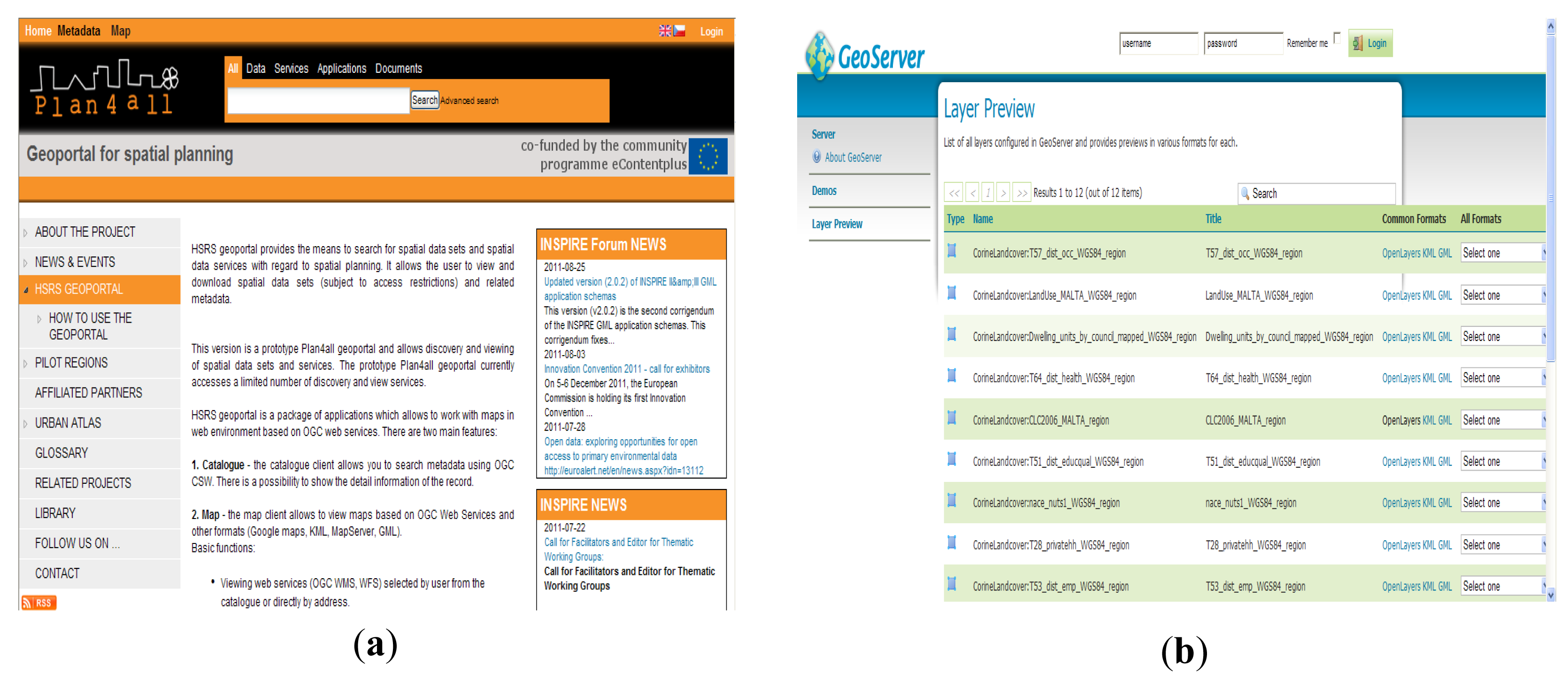
The Plan4all project's focus on the definition of common procedures and methods for spatial planning data interoperability and harmonisation is something that CRISOLA aims to take up. CRISOLA can employ Plan4all metadata profile and object-oriented data models for data sharing via the Plan4all geoportal or as implemented in Malta through the FTZ geoserver (Figure 5a,b respectively showing the mapserver interfaces) and guide them towards take-up within the social themes, themes that are not covered by the INSPIRE Annexes. The CRISOLA outputs can be brought into the Plan4all fold through the alignment of the already existent metadata, models and geoportal. Due to the fact that most of the data within the CRISOLA model falls within the landuse component, the direct linkage to the Plan4all is seen as the natural evolution for the model. The commonalities between CRISOLA and Plan4all lie in the fact that both profess a goal to support the exchange of compatible spatial planning data and to support the access to the data. Both have made access possible through options varying from simply viewing spatial data, up to even having the right to download it. Plan4all's concept to move away from ‘insular information islands’ towards ‘information systems’ and ‘information infrastructures’ that allow different kinds of user access to spatial data from various sources is seen as the springboard to use the functionality for social thematic spatial dataset creation [48,49]. In Malta social data is rarely created into spatial format and CRISOLA managed to link the landuse domain to the social domain and show that policy making can be done using such outputs. The next step is to take it to a full web-map format but within an established framework, which has been presented by INSPIRE and actuated in part by Plan4all.
This can be done for CRISOLA since the Plan4all geoportal [50] and the Malta FTZ geoportal [51] presents geographic information from various sources in a unified way. The Plan4all geoportal has two features that are basically map and catalogue. The catalogue client allows searching for metadata using OGC Catalogue Service for Web (CSW), something unheard of in the social domains. The map client allows viewing maps based on OGC Web Services and other formats (Google maps, KML, MapServer, GML). The basic functions include viewing web services (OGC WMS, WFS) selected by user from the catalogue or directly by address; ability to save user-defined map projects on local hard drive (OGC WMC); distance and area measurement; searching in the map; inserting user-defined objects into the map, large format printing in PDF; showing legends, metadata and querying in the map.
3. Results and Discussion
3.1. Employing Landcover to Test the Process
As part of an example to check whether it is possible to convey the process from a sample dataset to a verifiable and compliant disseminated layer, the case was made for the establishment of the Maltese Landcover dataset which was created by the national environment agency (Malta Environment and Planning Authority) as well as the European Environment Agency. The dataset was acquired and transformed to conform to the INSPIRE [52] revisions as established by the revised draft guidelines. The data source used was that prepared for the Land Cover Mapping in Malta for the years 1990, 2000 and 2006, which included 19 categories (landcover types). The mapping exercise was based on the analysis of different data sources; remotely-sensed data employing Landsat TM7; data pertaining to the National Mapping Agency at MEPA including base maps; orthoimagery; thematic data and in situ surveys. All document creation and metadata is available from the EEA CDR website [53].
The schema used for this exercise was that identified by the Plan4all guidelines and the Application Schema as the “Land Cover” Schema, where most of the attributes were not included in the original CLC2006 map and in turn new datasets had to be integrated in order to follow this schema. This transformation exercise was further enhanced through the implementation of the updated INSPIRE data specifications published in June 2011 which added new attributes not formerly in the Plan4all schema and which ensure that all the different datasets across the EU conform to the same requirements inclusive of projection, styled layer descriptor (SLD) and object type.
The spatial transformation was more complex due to the fact that Malta holds all its data in a truncated ED50 format which required following a number of steps in order to achieve transformation to the final required projection. This required the restoration of the truncated 4 in Northings and 39 in Eastings, a reprojecting to WGS84: EPSG: 36233, conversion to shp format from .tab format (which in Malta was originally in MapInfo .tab polygon format and was converted to ESRI .shp format for this exercise). The latter causes a problem due to the fact that the attribute names are truncated due to the ANSI conversion protocols experienced. Another issue envisaged in the transformation was that most attributes had to be given a “string” type and to ensure the re-establishment of the colour schemes that were lost in the transition and needed to be recreated in the geoserver.
The metadata part of process was enabled through the employment of the INSPIRE Metadata Editor [54] made available by the Joint Research Centre (JRC). The output was read through an xml tool that was created through a project entitled “Institution Building in the Environment Sector”, which was part of the Transition Facility Programme for Malta–2006. The process entailed reviewing the Plan4all Metadata Documentation through the Plan4all Portal which was used for both creation and storage which for the Maltese case both xml and xls versions were created. This ensured that users without xml readers could still review the metadata. This process was further enhanced through the employment of the relative feature catalogues, UML Models and the knowledge of basic coding which allowed editing of the SLD layers pertaining to each particular data layer. In this case two SLD files were created due to the fact that the attribute which pointed to the “Classification” attribute in the revised schema pointed to the “coverageName” attribute. The original colour scheme (Figure 6a) established by the EEA was transformed to an interim grey-polygon version (Figure 6b) until the final SLD was established which resulted in the final colour scheme for the project (Figure 6c).
The final parts of the process entailed the verification and testing processes which were carried out on the data input, indicators and changes steps effected during the transformation process. The data uploads to the geoserver were finally established through ftp transfer, structuring of the maps through the open source application's Stores, Layers and colour schemes. This resulted in the online dissemination of maps that followed the INSPIRE data-sharing and re-use services (discovery, view, download and transformation services).
The Plan4all and the Malta FTZ geoportals enable users to search and view harmonised spatial planning data from the Plan4all partners with the aim to further extend the network with affiliated partners (Plan4all geoportal, http://www.plan4all.eu).
The steps followed above enabled the implementation of the first web-map as uploaded to the FTZ geoserver and to the Plan4all geoportals. The process employed for this dataset was based on an INSPIRE Annex II data layer but can be extended to other Annex II and Annex II data layers using the appropriate schemas and guidelines. Once the process was established, the exercise was extended for the landuse spatial data theme using the “Land Use” Schema established by Plan4all.
3.2. Planning for the Transformation of the Social and Criminological Datasets
This process was taken to the next step through the transformation of social dataset samples. This was achieved through the initial transformation of a number of datasets from the Malta Census 2005. This was based on the application of a surrogate schema (Area management/restriction/reregulation zones and reporting units), the Human health and safety Schema [55] and the Population distribution– demography schema [56], which were not part of the Plan4all activities but will be tested under the relative data specifications draft guidelines once the data specifications are finalised. The resultant metadata and maps were uploaded to the Plan4all geoportal and to the Malta FTZ geoportal, with the sld yet to be established for the various attributes.
CRISOLA will take the next step and strive to extend that process to the social domains employing the different schemas within which the criminological and social datasets would fit in, particularly where such do not exist in the Annexes. This will be carried out due to the fact that in various instances, the other schemas provide a base for the preparation of the data layers, whilst the Plan4all established regime will provide a verifiable series of INSPIRE-compliant datasets.
3.3. The Next Steps for Data and Webmap Access in the Maltese Islands
CRISOLA will not make it simply by employing the Plan4all methodology and operating around that structure's available specifications; it needs new data feeds to ensure that the dynamic social structures are backed by new and updated protocols and actual datasets. This is coming in the form of the next phase for web mapping and dissemination in Malta as currently being developed through an extensive Maltese ERDF project [57] which entails the integration of physical, social and environmental data within a comprehensive Shared Environmental Information System [58] structure as proposed by the EC. Having experienced instances of lack of data, a dearth of metadata on one hand and a relentless drive to take up new technologies, the Maltese scenario is ripe to integrate all the three CRISOLA issues (together with other thematic natural-social-physical environments) through the employment of hi-end technology located both in situ and remotely. The resultant output will employ data-capture and scanning technologies that may yet make inroads in the social and planning operational fields. Through a planned complete terrestrial LIDAR scan combined with a bathymetric acoustic scan up to one nautical mile from the baseline coast and the inclusion of bathymetric LIDAR ensuring consistency in data acquisition across the two surveys, the baseline data will be created for the eventual overlaying of the thematic data which will combine the three CRISOLA themes. Integrated with oblique imagery and in-situ data trawling, the end result should enable the production of a unique model of the islands for use across the scientific platforms.
The envisaged free dissemination of the data through Aarhus-compliance to the general public and the scientific community should enable the launching of integrated research across the spatial and social themes. Urban and environmental planners can undertake urban modeling scenario-building for strategic, regional and local areas, with the add-on integration of social, economic and criminological issues leading to healthier and safer localities. In addition, the data will be integrated with impact-analysis of baseline studies for air, water, noise, soil and radiation themes and their impacts on high population/urban density Malta. It is envisaged that the project outputs will serve as a base for the creation of updated data for the crimemaps, which outputs will also be disseminated to other geoportals inclusive of the Plan4all geoportal in a harmonized format, thus ensuring homogeneity across the datasets. Thus the base landuse-related data requirement will be supplied through the ERDF project and the social data will be delivered through the Census 2011, which would require georeferencing and structuring in order to allow integration with the Plan4all requirements. The next step would require the integration of the crimemaps within the Plan4all mapserver which calls for integration of the original (pre-geoclip) spatial datasets within the metadata profile to ensure that the data fits within the geoportal.
4. Conclusions
As the CRISOLA landuse base data are the same used for the Plan4all geoportal harmonization should not offer major obstacles, especially since the base data layers created for the crimemaps adhered to the INSPIRE requirements. Malta's datasets originate from one data source, the National Mapping Agency which has employed the JRC metadata editor since its launching phase, thus the crime data fits within the requirements for that structure. In addition, whilst the current geoportals do not allow for user-interaction in terms of polygon creation at source, it is envisaged that such options be integrated in the project output to allow users to feed in into the online system.
Geographic data harmonization initiatives and projects such as Plan4all form a network of several thematic information systems—one being the Maltese Crime map—by providing harmonised, interoperable and accessible spatial data. The next phase for CRISOLA will see its integration of the Plan4all three main objectives that encompass the definition of standards for spatial planning data harmonisation according to INSPIRE, the implementation of the Plan4all geoportal that consists of harmonised spatial planning data that can be shared and third, to contribute to a European spatial data infrastructure. This study has shown that following the requirements of INSPIRE, a successful outcome is possible, thus it is expected that the take-up by CRISOLA of the Plan4all data models and geoservers will be an important input to ensure that the initiation of social spatial datasets is set on a solid base.


Acknowledgments
Main acknowledgements go to FTZ for the help received in the process to contribute to the Plan4all project and use of their geoserver. Acknowledgements also go to the Information Resources Unit at the Malta Environment & Planning Authority who created the original Landcover data layer.
References and Notes
- Shaw, C.R.; McKay, H.D. Juvenile Delinquency and Urban Areas; University of Chicago Press: Chicago, IL, USA, 1942. [Google Scholar]
- The Oxford Handbook of Criminology, 2nd ed.; Maguire, M., Morgan, R., Reiner, R., Eds.; Oxford University Press: New York, NY, USA, 1997; p. 308.
- Entorf, H.; Spengler, H. Socio-economic and demographic factors of crime in Germany: Evidence from Panel Data of the German States. Int. Rev. Law Econ. 2000, 20, 75–106. [Google Scholar]
- Brantingham, P.L.; Brantingham, P.J. The relative spatial concentration on criminality and its analysis: toward a revival of environmental criminology. Criminologie 1994, 27, 81–97. [Google Scholar]
- LeBeau, J.L.; Leitner, M. Introduction: Progress in research on the geography of crime. Prof. Geogr. 2011, 63, 161–173. [Google Scholar]
- Formosa, S. Spatial Analysis of Temporal Criminality Evolution: An Environmental Criminology Study of Crime in the Maltese Islands. Ph.D. Thesis, University of Huddersfield, Huddersfield, UK, 2007. [Google Scholar]
- Formosa, S. Maltese Criminological Landscapes: A Spatio-Temporal Case Where Physical and Social Worlds Meet. In Peer Reviewed Proceedings of Digital Landscape Architecture 2010; Buhmann, E., Pietsch, M., Kretzler, E., Eds.; Wichmann Verlag Heidelberg: Berlin, Germany, 2010. [Google Scholar]
- Chainey, S.; Ratcliffe, J. GIS and Crime Mapping: (Mastering GIS: Technology, Applications & Management); John Wiley & Sons: Chichester, UK, 2005. [Google Scholar]
- Schneider, R.H.; Kitchen, T. Crime Prevention and the Built Environment; Routledge: Oxon, UK, 2007. [Google Scholar]
- Felson, M.; Clarke, R.V. Opportunity Makes the Thief: Practical Theory for Crime Prevention; Police Research Series, Paper 98; Home Office Policing and Reducing Crime Unit Research, Development and Statistics Directorate: London, UK, 1998. [Google Scholar]
- Ekblom, P. The Conjunction of Criminal Opportunity: A Framework for Crime Reduction Toolkits; Policing and Reducing Crime Unit Research, Development and Statistics Directorate Home Office: London, UK, 2001. [Google Scholar]
- Mapping and Analysis for Public Safety. Available online: http://www.ojp.usdoj.gov/nij/maps/ (accessed on 16 December 2011).
- Fritz, N. The Growth of a Profession: A Research Means to a Public Safety End. In Advances Crime Mapping Techniques. Results of the First Invitational Advanced Crime Mapping Topics Symposium: June 2001; CMAP: Denver, CO, USA, 2002. [Google Scholar]
- The acronym INSPIRE refers to the Directive 2007/2/EC of the European parliament and the Council of 14 March 2007 with the aim to establish an Infrastructure for Spatial Information in the European Community. The directive entered into force on 15 May 2007 and will be fully implemented by member states in 2019.
- Bruce, C.W. Killing Crime at its Root. In Advances Crime Mapping Techniques, Results of the First Invitational Advanced Crime Mapping Topics Symposium: June 2001; CMAP: Denver, CO, USA, 2002. [Google Scholar]
- Pease, K. What to Do About It? Lets Turn Off Our Minds and GIS. In Mapping and Analysing Crime Data: Lessons from Research and Practice; Hirschfield, A., Bowers, K., Eds.; Taylor & Francis: London, UK, 2001. [Google Scholar]
- UK Home Office Website. Available online: http://www.homeoffice.gov.uk/ (accessed on 16 December 2011).
- Office of Justice Program. Available online: http://www.ojp.usdoj.gov/ (accessed on 16 December 2011).
- Interpol. Available online: http://www.interpol.int/ (accessed on 16 December 2011).
- Europol. Available online: https://www.europol.europa.eu/ (accessed on 16 December 2011).
- University of Sheffield School of law. Available online: http://www.shef.ac.uk/law/research (accessed on 16 December 2011).
- Applied Criminology Centre. Available online: http://www.hud.ac.uk/acc/ (accessed on 16 December 2011).
- UCL Jill Dando Institute of Security and Crime Science. Available online: http://www.ucl.ac.uk/jdi/ (accessed on 16 December 2011).
- Crime, order(ing), urban change and social justice Available online: http://www.liv.ac.uk/law-and-social-justice/research/crime/ (accessed on 16 December 2011).
- Institute of Criminology. Available online: http://www.um.edu.mt/criminology/ (accessed on 16 December 2011).
- Giddens, A. The Constitution of Society: Outline of the Theory of Structuration; Polity Press: Cambridge, UK, 1984. [Google Scholar]
- CrimeStat Spatial Statistics Program – Version 3. Available online: http://www.icpsr.umich.edu/CrimeStat/ (accessed on 16 December 2011).
- Levine, N.L.; CrimeStat. A Spatial Statistics Program for the Analysis of Crime Incident Locations (v 2.0); Ned Levine & Associates: Houston, TX; National Institute of Justice: Washington, DC, USA, 2002. [Google Scholar]
- Law Enforcement. Available online: http://www.esri.com/industries/public-safety/law-enforcement/index.html (accessed on 16 December 2011).
- MapInfo Crime Profiler. Available online: http://www.pbinsight.com/products/location-intelligence/applications/mapping-analytical/mapinfo-crime-profiler/ (accessed on 16 December 2011).
- Software for Crime Analysis. Available online: http://www.jratcliffe.net/ware/index.htm (accessed on 16 December 2011).
- MapInfo Vertical Mapper. Available online: http://www.pbinsight.com/products/location-intelligence/applications/mapping-analytical/vertical-mapper/ (accessed on 16 December 2011).
- Craglia, M.; Haining, R.; Wiles, P. A comparative evaluation of approaches to urban crime pattern analysis. Urban Stud. 2000, 37, 711–729. [Google Scholar]
- Urban crime pattern analysis in Sheffield. Available online: http://www.geog.cam.ac.uk/research/projects/camgis/urbancrimepatternanalysis/ (accessed on 16 December 2011).
- Illinois Statistical Analysis Center. Available online: http://www.icjia.org/public/sac/index.cfm (accessed on 16 December 2011).
- Web-mapping the 1995 Census of the Maltese Islands. Available online: http://www.mepa.org.mt/Census/index.htm (accessed on 16 December 2011).
- Formosa, S. Coming of Age: Investigating the Conception of a Census Web-Mapping Service for the Maltese Islands. MSc Thesis; University of Huddersfield: Huddersfield, UK, 2000. Available online: http://www.mepa.org.mt/Census/index.htm (accessed on 16 December 2011). [Google Scholar]
- Malta Environment & Planning Authority. Available online: http://www.mepa.org.mt/home?l=1 (accessed on 16 December 2011).
- Pitney Bowes. Available online: http://www.pbinsight.com/ (accessed on 16 December 2011).
- Census2005 maps. Available online: http://www.nso.gov.mt/site/page.aspx?pageid=570 (accessed on 16 December 2011).
- Geoclip. Available online: http://www.geoclip.net (accessed on 16 December 2011).
- European Environment Agency. Available online: http://www.eea.europa.eu/ (accessed on 16 December 2011).
- Environmental Portal (MT). Available online: http://www.nesis.eu/index.php?option=com_wrapper&view=wrapper&Itemid=158 (accessed on 16 December 2011).
- Official Journal of the European Union: Directive 2007/2/EC of the European Parliament and of the Council of 14 March 2007. Establishing an Infrastructure for Spatial Information in the European Community (INSPIRE), 2007, 50, p. L108. Available online: http://eur-lex.europa.eu/LexUriServ/LexUriServ.do?uri=CELEX:32007L0002:EN:NOT (accessed on 16 December 2011).
- Plan4all: European Network of Best Practices for Interoperability of Spatial Planning Information. Plan4All is a European Community programme to make digital content in Europe more accessible, usable and exploitable.
- Plan4all Deliverable 2.3, Analysis of INSPIRE requirements 2009. Available online: http://www.plan4all.eu/extractor/fileReader.php?file=d2-3-inspire-requirements-analysis.pdf (accessed on 16 December 2011).
- Kafka, S.; Fiala, R. Plan4all metadata profile, 2010. Plan4all Deliverable 3.2.2, Available online: http://www.slideshare.net/plan4all/d322-plan4all-metadata-profile (accessed on 16 December 2011).
- Beyer, C.; Wasserburger, W.W. Analysis of innovative challenges. Plan4all Deliverable 2.2, Available online: http://www.plan4all.eu/extractor/fileReader.php?file=d2-2-analysis-of-innovative-challenges.pdf (accessed on 16 December 2011).
- Rubitzki, I.; Vancutsem, D. Clusters of leading organisations in SDI for spatial planning, 2009. Plan4all Deliverable 2.1, Available online: http://www.slideshare.net/plan4all/d21-cluster-ofleadingorganisationsinsdiforspatialplanning (accessed on 16 December 2011).
- Pla4all Geoportal for Spatial Planning. Available online: http://www.plan4all.eu (accessed on October 2010–September 2011).
- FTZ Geoserver. Available online: http://ftzgeo.org:8080/geoserver/web/ (accessed on October 2010–September 2011).
- INSPIRE (Infrastructure for Spatial Information in Europe). D2.8.II/III.4 INSPIRE Data Specification on Land Cover – Draft Guidelines. Available online: http://inspire.jrc.ec.europa.eu/documents/Data_Specifications/INSPIRE_DataSpecification_LC_v2.0.pdf.
- CLC2006 inclusive of CLC1990 and CLC2000 revision. Available online: http://cdr.eionet.europa.eu/mt/eea/colrnupsa (accessed on 16 December 2011).
- Metadata on metadata. Available online: http://www.inspire-geoportal.eu/EUOSME/ (accessed on 16 December 2011).
- INSPIRE Thematic Working Group INSPIRE Thematic Working Group Statistical Units -Population distribution - demography. D2.8.III.10 INSPIRE Data Specification on Population distribution - demography – Draft Guidelines, June 2011. Available online: http://inspire.jrc.ec.europa.eu/index.cfm/pageid/241/documentid/2647 (accessed on 16 December 2011).
- INSPIRE Thematic Working Group Human Health and Safety. D2.8.II/III.5 INSPIRE Data Specification on Human Health and Safety – Draft Guidelines, June 2011. Available online: http://inspire.jrc.ec.europa.eu/index.cfm/pageid/241/documentid/2620 (accessed on 16 December 2011).
- Environmental Monitoring Tenders Worth €3.6 Million. Available online: http://www.mepa.org.mt/news-details?id=603 (accessed on 16 December 2011).
- Shared Environmental Information System. Available online: http://ec.europa.eu/environment/seis/ (accessed on 16 December 2011).
© 2011 by the authors; licensee MDPI, Basel, Switzerland. This article is an open access article distributed under the terms and conditions of the Creative Commons Attribution license (http://creativecommons.org/licenses/by/3.0/).
Share and Cite
Formosa, S.; Magri, V.; Neuschmid, J.; Schrenk, M. Sharing Integrated Spatial and Thematic Data: The CRISOLA Case for Malta and the European Project Plan4all Process. Future Internet 2011, 3, 344-361. https://doi.org/10.3390/fi3040344
Formosa S, Magri V, Neuschmid J, Schrenk M. Sharing Integrated Spatial and Thematic Data: The CRISOLA Case for Malta and the European Project Plan4all Process. Future Internet. 2011; 3(4):344-361. https://doi.org/10.3390/fi3040344
Chicago/Turabian StyleFormosa, Saviour, Vincent Magri, Julia Neuschmid, and Manfred Schrenk. 2011. "Sharing Integrated Spatial and Thematic Data: The CRISOLA Case for Malta and the European Project Plan4all Process" Future Internet 3, no. 4: 344-361. https://doi.org/10.3390/fi3040344