Article

Citizen Science as a Tool in Biological Recording—A Case Study of Ailanthus altissima (Mill.) Swingle

Institute of Agriculture and Tourism, Karla Huguesa 8, 52440 Poreč, Croatia
*
Author to whom correspondence should be addressed.
Forests 2018, 9(1), 31; https://doi.org/10.3390/f9010031
Submission received: 24 November 2017 / Revised: 21 December 2017 / Accepted: 10 January 2018 / Published: 13 January 2018
(This article belongs to the Section Forest Economics, Policy, and Social Science)

Abstract

:
Non-native invasive species frequently appear in urban and non-urban ecosystems and may become a threat to biodiversity. Some of these newcomers are introduced accidentally, and others are introduced through a sequence of events caused by conscious human decisions. Involving the general public in biodiversity preservation activities could prevent the negative consequences of these actions. Accurate and reliable data collecting is the first step in invasive species management, and citizen science can be a useful tool to collect data and engage the public in science. We present a case study of biological recording of tree of heaven (Ailanthus altissima (Mill.) Swingle) using a participatory citizen model. The first goal in this case study was to develop a cheap, widely accessible, and effective inventory method, and to test it by mapping tree of heaven in Croatia. A total of 90.61 km of roads and trails was mapped; 20 single plants and 19 multi-plant clusters (mapped as polygons) were detected. The total infested area was 2610 m2. The second goal was to educate citizens and raise awareness of this invasive species. The developed tool and suggested approach aided in improving invasive risk management in accordance with citizen science principles and can be applied to other species or areas.

1. Introduction

Scientists have devoted significant energy to determining the principles of alien species invasions [1]. Alien species invasion is recognised as one of the most severe and demanding global environmental threats [2]. Therefore, the impacts of these species should be comprehensively assessed [3]. Human activities have caused ecological conditions in the urban flora that render them suitable for alien species settlement [4]. Generally, invasive alien species are considered a consequence of globalisation, and they may spread into new environments in many ways, some intentional and some accidental. Even if a large share of invasive species was transported unintentionally, such as via ship ballast waters, systems of canals and dams, or cargo holds, many other cases have been caused by a sequence of events based on conscious human decisions. Many recently introduced invasive species were originally introduced as ornamental or erosion control plants—these include tree of heaven (Ailanthus altissima (Mill.) Swingle) [5] and beach vitex (Vitex rotundifolia L. f.) [6]. In some cases, invasive species were introduced in an attempt to control other invasive species—for example, several species of mongoose [7]. On the other hand, some species are imported to different places intentionally, but released by mistake—these include Caulerpa taxifolia (M. Vahl) C. Agardh [8] into the Mediterranean region, and lionfish (Pterois spp.) [9] and python (Python spp.) in Florida [10]. Although certainly not all human acts leading to invasions have been performed with the goal of causing larger ecological and biodiversity damage, but are simply the consequences of a lack of information or education, they still have global repercussions. Such decisions would probably have been made to a lesser extent if the actors had been better informed. The fact that a limited number of scientists are well-informed about the possible consequences does not help the general picture where non-professionals are responsible for concrete environmental changes. The involvement of the wider public in science is known as “citizen science”. This approach, described as the participation of the general public in scientific research, dates back to the 19th century [11]. Citizen involvement in data collection and monitoring offers the public an appealing opportunity to participate in research, and allows them to benefit from the learning experience [12,13]. Citizen science is a tool of participatory conservation that has numerous and differently named models, and has been identified as the most acceptable sustainable environmental approach [14]. Efficient urban ecosystem management requires bringing science, policy, and citizen participation together [15]. The continuing evolution and spread of the Internet and other communication technologies in recent years has increased the number of citizen science projects in many disciplines. Environmental education within these projects, in particular, those concerning invasive species, makes the public aware of their role in this conservation issue and consequently encourages them to support future initiatives for the prevention of the further spread of invasive species [16,17,18]. Public education is one of the best methods of citizen involvement in the process of democratic decision making and policy creation, especially in fields of ecology, new technologies, and other sciences, and could also be a successful tool in preventing future bad decision making (Figure 1).
To be efficient, citizen involvement should not be time consuming or boring, require complicated or expensive tools, or be expensive to perform. Its direct results are relevant, but they are only a part of the complete list of benefits. The following case study describes the current status of an alien plant invasion caused by the unintended consequences of bad decisions and is an example of citizen science with a goal of improving the environment and possibly preventing future mistakes in invasive alien species management in Croatia.

Case Study—Biological Recording of Ailanthus altissima

Tree of heaven (Ailanthus altissima) is one of today’s most invasive plant species, present on all continents except Antarctica [19,20,21], preferring urban and highly localised disturbed areas [1]. It was introduced from China to Europe (Paris) in the 1740s primarily as an ornamental tree [22]. There are no written records of the exact year of introduction in Croatia, but it is certain that it was planted in gardens as a decorative plant [23]. Although there are many studies focused on various aspects of A. altissima around the world [22], only a few studies have been conducted on biological recording models [24,25,26], and, as far as we know, there have been none that connect participatory concepts with this invasive species.
In Croatia, A. altissima is established in all regions, especially coastal areas; it is spreading in many urban areas, on islands, and in protected areas [27,28]. Despite this, there has been no systematic biological recording, monitoring, or management of this species. On the national level, there are activities planned that are aimed at effective management of its population in the future [23]. Sporadic biological recording has been performed so far by ground-based visual methods, and there is no continuous long-term monitoring [23,29,30]. In the city of Poreč, this plant was introduced as an ornamental and planted in some private and public gardens. To date, sporadic activities for raising awareness of this and similar ecological issues have not engendered much interest and a new approach is needed. Moreover, the real number and area of occurrences was not known, and data were needed to form the basis for an invasive risk management plan.
Invasive species biological recording, mapping, and monitoring are prerequisites for successful biological invasion risk management [31,32,33] and to prevent invasive species expansion into large areas, where eradication becomes very difficult and costly [1]. Among invasive plants, trees are generally easiest to map because of their size [34], although there is currently no methodical, reasonably priced protocol for the estimation of tree invasions that can be used in invasive species management or scientific research [35]. Conducting invasive plant inventories is a critical component of an integrated approach to invasive plant management [26]. One of the first, crucial steps in an effective management strategy is the estimation of invasive species abundance and distribution [1]. Inventory data often provide the information necessary to evaluate the extent of plant invasion, allowing land managers to prioritise management efforts; however, these data are often expensive to collect [36].
New communication technologies have popularised citizen science and allowed for instant transmission of data, the combination of electronic sensor data with observation logs, and the validation of observations in real time. The most commonly used mapping systems and tools in plant management are traditional ground-based visual methods, handheld GPS (Global Positioning System), aerial and other remote methods [37], and innovative high-definition video systems [38]. Several applications (apps) for tracking invasive species with mobile smart phones have been developed in the USA (including iMapInvasives, IPAlert, IveGot1, IceGot1, Southeast Early Detection Network SEEDN, EDDMapS, What’s Invasive, and Stink Bug Scout), and are used as invasive species management tools (http://ecospotinvasivespecies.weebly.com/mobile-apps-used-to-track-invasive-species.html). These apps, although free to use, full of useful features, and handy, were created to include the general public in ongoing biological recording of selected species and locations in the USA, and cannot be used for other species or localities outside the USA. Also, in Europe, a number of apps have been developed for the same purpose, among them EASIN (European Alien Species Information Network) developed by JRC (Joint Research Centre of EU Commission, Brussels, Belgium), RINSE That’s Invasive! app, KORINA app, Plantas Invasoras app, and IASTracker app. The potential usefulness of wearable sensors and smartphones has recently been described by Savage (2015) [39]. It has been stated that virtual globes, particularly Google Earth, are readily available, free, and handy, and have enormous potential in invasion science. Their practical use as tools for identification and monitoring of plant invasions and data presentation has been recognised [36].
To involve the local people in A. altissima data acquisition, we developed a cheap, widely accessible, and effective mapping method, and tested it with a case study of A. altissima. We mapped urban and suburban areas of the City of Poreč, Croatia, South-East Europe (Figure 2), using a participatory citizen model. We expected that this and similar emerging mobile tools would enable more efficient data collection for invasive species, assure more efficient invasive species management, and educate the people and consequently prevent future bad decisions regarding invasive species. Some of these results may be seen in future years.

2. Materials and Methods

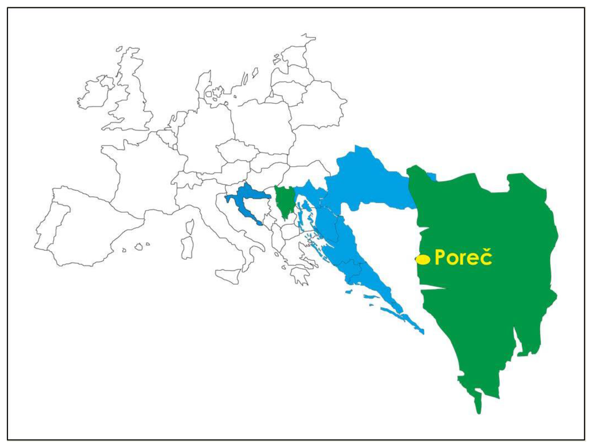
2.1. Case Study—Biological Recording of Ailanthus altissima

Smartphones equipped with GPS, camera, the TrackMyTour app (TMT; https://trackmytour.com/), and the LocaToWeb app (LTW; https://locatoweb.com/) were used to collect data on A. altissima presence. Smartphone GPS-based solutions are highly accurate, with accuracy within an estimated 3–5 m under ideal conditions [40]. Both apps are available for free at the app store. The TrackMyTour app is a travel-tracking app that allows the creation of an online map and a microblog of movement. It can record the latitude, longitude, and altitude of each waypoint, and has an option to describe particular waypoints (i.e., infestation sites) and to upload photos related to each waypoint. TMT is not a real-time tracker, but waypoints can be created offline and submitted later, when a connection is possible. Moreover, it allows for direct upload from several smartphones to a common web account. Maps are exported in kml file format. TMT was not used for tracking the path because it connects the recorded points linearly instead of following the real trajectory. LTW, however, can track the real trajectory and calculate distance and time covered by car or bike or on foot. For that reason, we used both apps. At the start of recording we activated both apps: LTW for trajectory tracking and TMT for data recording. Data recorded offline were later submitted online in gpx format. All data (both kml and gpx files) were imported into the downloadable free software Google Earth Pro (http://www.google.com/earth/download/gep/agree.html). The data from both apps were merged into a kmz format file. Data processed and saved in Google Earth Pro can be edited, so tracks were highlighted (Figure 3), and different colours, sizes, photos, and comments were assigned to each waypoint (Figure 4 and Figure 5), and implemented on the web, enabling a second step of public access. All data were collected from August to November 2015.

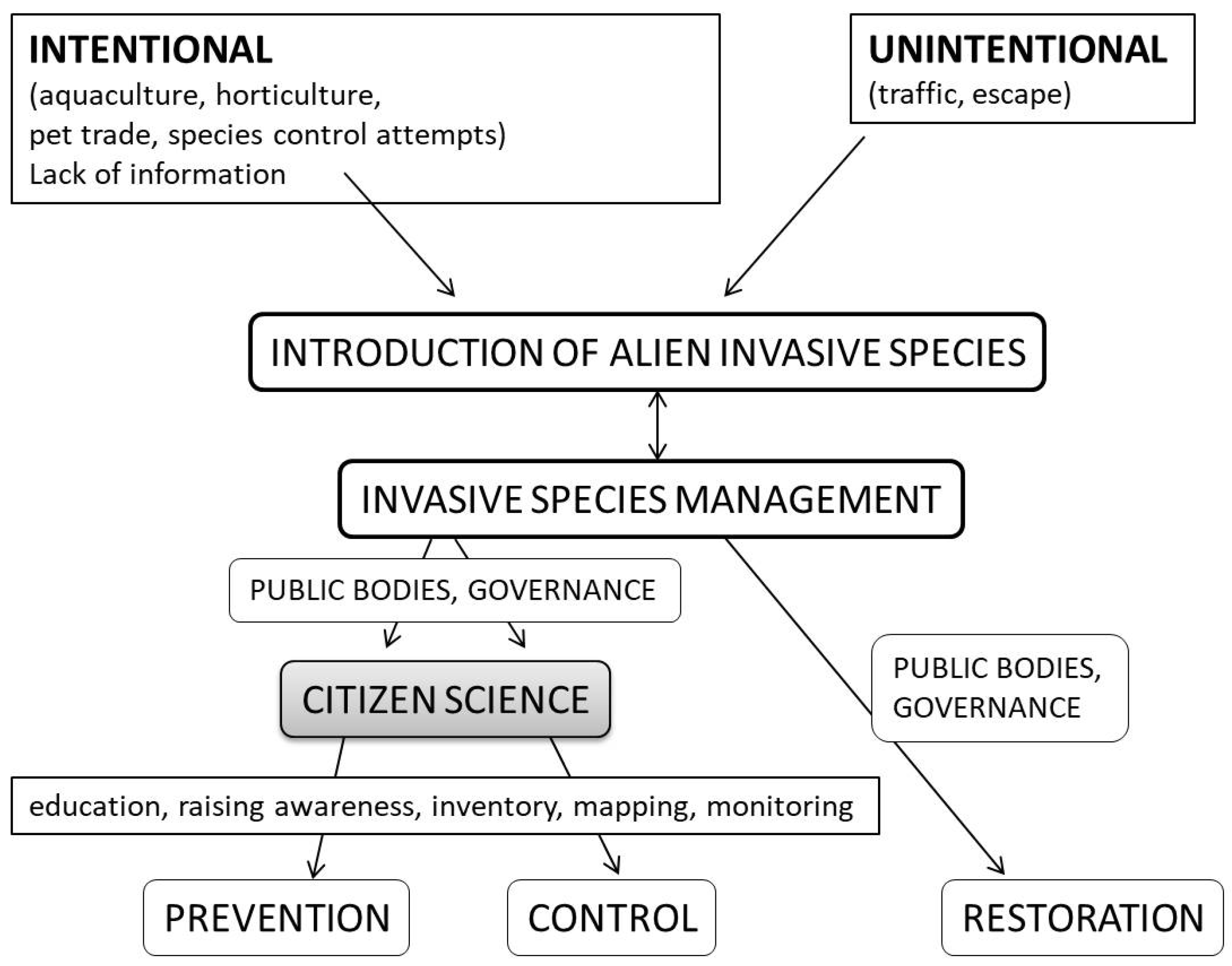
2.2. Citizen Science in Biological Recording
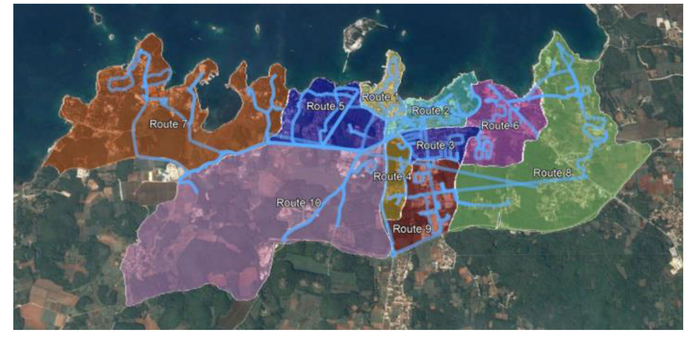
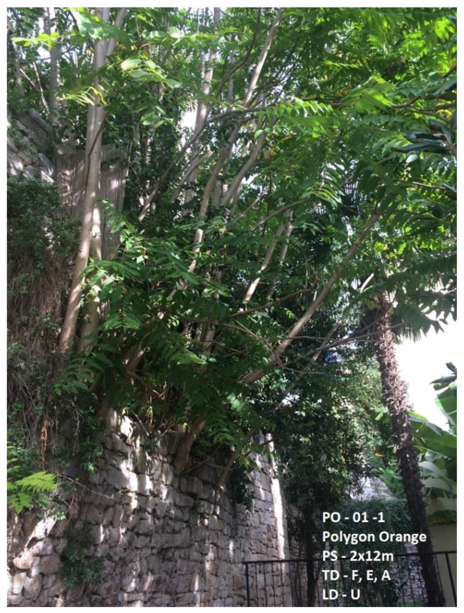
The recording methods involved recorders on foot, bike, or car, who inputted A. altissima infestation data into handheld smartphones. Recorders were recruited via personal contacts, social networks, emails, or telephone calls. We offered no material incentives. We decided to select environmentally educated or highly motivated recorders and to invest time and money in training and motivating. If recorders were able to undertake the hiking or biking, or had an available car, and could attend the training session, they were accepted. Recorders attended one half-day training session led by the authors. Training included theoretical and practical information related to all aspects of mapping methodology (identification, mobile application handling, data recording, and processing). Recorders collected data individually, in pairs, or in the case of young students, in groups of four to five. We assigned each recorder, whether hiking, biking, or driving, a specific stretch of trail or road on which to record the presence and abundance of A. altissima. Recorders scanned for the target species in two 20-m zones, one on each side of the trail or road. Recording zones were chosen because of its shade intolerance and thus preferences for open areas along roads, trails, abandoned lots, and parks. We instructed recorders to not leave their assigned route. Biological recording was performed by different categories of citizens, according to age, education, and occupation, with a total of 62 recorders: 4 scientists, 4 teachers, 46 students (21 high school students and 25 elementary school students), 3 university students, and 5 volunteers (3 retirees and 2 adults), which was optimal for efficient recording organization. Infestation was recorded by visual estimation and exact measurements.
Owing to the significant population dynamics and areas of high plant density, counting all single trees was not possible, and therefore data was simplified by using polygons—a four-squares drown approximately following per the natural plant distribution.
Ailanthus altissima plants were censused, mapped, and measured as follows: (1) Each located plant or cluster of up to five plants was plotted with a virtual pin at the corresponding position on the map in TMT; (2) Plants were classified into four groups (D1–D4) based on the tree diameter (d): D1, d < 3 cm; D2, d = 3–8 cm; D3, d = 8–18 cm; D4, d > 18 cm). For each plant in group D4, the diameter at breast height (DBH) was measured using a handheld meter; (3) If the infestation included more than five plants, it was recorded as a polygon; (4) Polygon areas were measured and clusters were marked with a pin in the centre of the drawn polygon; (5) To indicate plant density, polygons were placed into one of three categories (represented by colours for online imaging) representing the population density: yellow, for areas with sparse plants (corresponding to no more than 1 plant/m2); orange, for dense areas (2–5 plants/m2) or mix of sparse and very dense areas, and red, for very dense areas (more than 5 plants/m2); (6) Other notes and specific site descriptions were recorded as comments.
We used multiple methods to ensure the accuracy of recorder-generated data. Our recording methodology led to low-quantity but high-quality records. Quality assurance methods were based on previous training, education in situ, and accurate route planning. Many possible biases were avoided by the fact that participants recorded only one species in a limited area, which permitted control of every site. A short training and demonstration about specific morphologic features, including the presence of extrafloral nectaries, enabled correct and reliable species identification with a misidentification rate of zero. All data were additionally checked by reviewing photo documentation taken by the recorders. When we suspected that a misidentification occurred, we verified the identification in situ. In order to eliminate biases in route selection, participants did not select their own survey locations but were instructed to follow assigned routes. Routes were planned by dividing the city map into sectors with exact roads and trails marked. Double counting was avoided by linking each record with its exact location.

2.3. Mapped Areas

Ailanthus altissima plants were monitored in urban and suburban areas of the City of Poreč, Croatia (Figure 2). Routes were examined in many different types of urban environments: the old town, public green areas, parks, roads, streets, walking paths, tree-lined avenues, uncultivated areas, bus stations, parking places, industrial areas, landfills, tourist resorts, and residential areas.

2.4. Harmfulness Assessment

The effects caused by A. altissima were estimated, recorded, and classified according to type (functional, environmental, aesthetic, health, and safety) and site (urban, suburban, and industrial). Effects estimations were based on either field records or subjective assessment based on theoretical knowledge. In the cases of specific effects (e.g., damage to architectural, historic, artistic, or archaeological items), experts were consulted. Estimates of invasiveness were calculated as the ratio of the area covered by A. altissima to the total examined area, as estimated using the route length plus a buffer of 20 m on each side. Alien species invasibility was calculated in terms of percent plant cover [41].

3. Results and Discussion
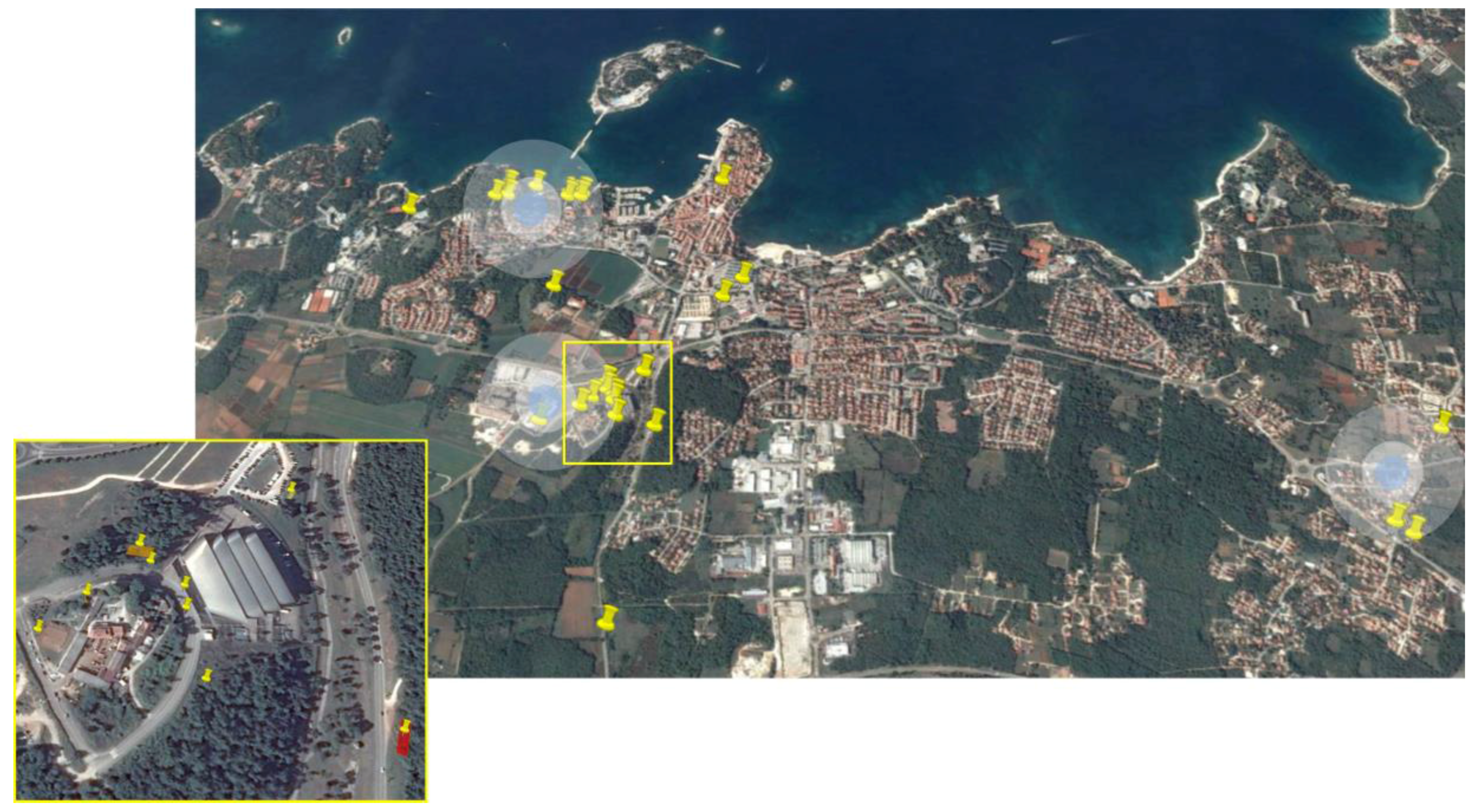
3.1. Surveyed Areas

The Poreč City area was divided into 10 sub-areas and corresponding routes (Table 1, Figure 3). The whole area was inspected using nearly 100 km of roads and trails. Along these routes, 39 infestation sites were found; there were 20 singular plants and 19 polygons (Table 1, Figure 4). Although the simplifications made by the introduction of polygons did not allow for detailed and precise data analysis, it also did not hinder the aim of this case study, which was to gain some insight into the infestation rate in the examined area. All invasive plants and site descriptions (Figure 5) were included in an online mapping database.

3.2. Harmfulness

Effects caused by A. altissima presence were determined visually or assumed and described. In total, there were 22 different types of damage or effects on different types of structures; these are presented in Table 2.
Ailanthus altissima invasibility in Poreč was calculated to be 0.072% of the total area surveyed. This result implies low invasion when compared to some other related published data [41,42], and it also indicates that eradication programs in this particular area may be successful.
The main focus of a high-quality invasive risk management plan is the knowledge of invasive plant distribution and abundance, which can therefore be used in identification of endangered areas with a high risk of invasion, evaluation of ecosystem impacts, continuous long-term invasion monitoring, early detection of new invasive species or locations, planning further management activities, and raising public awareness about invasive species [36]. The analysis of the urban appearance of invasive species is a complex topic that is still under investigation. Urban areas are characterized by complex ecological relationships and influenced by modified environmental conditions, as well as anthropogenic factors [43]. In these circumstances, invasive species with a wide ecological tolerance enjoy a significant advantage, and therefore it is very difficult to predict their future spread. Because of this, continuous biological recording in particular areas is recommended. Biological recording is the first step in an invasive risk management plan, and the methods for such recording should be easily available and efficient. Ecological inventories can have additional advantages: detailed surveys provide basic data for monitoring programs, whereas inventory maps provide important documentation of population status and management actions, maintenance of long-term continuity of staff knowledge, and justification for requested or approved funding. Additionally, inventory maps can be used as outreach and education tools for government personnel and policymakers and to improve public knowledge. Biological recording produces valuable datasets to scientists, governments, and land managers and can be successfully based on volunteer contributions, activities known as “citizen science”. In some countries, such as the United Kingdom, citizen science has a long tradition that started as biological recordings performed by thousands of people across the country [44]. The contribution of volunteer experts to ecology and conservation has been very important in Britain and Ireland over the past 50 years [44,45,46]. In practice, however, there can be some difficulties in obtaining and analysing data gathered by citizen scientists, including double-counting [47]. In our case, we had delayed recording due to personal reasons of some volunteers, as well as technical issues related to the use of the apps (especially with older participants) and to compiling data in the final interactive map. In the present recording we have still not sufficiently involved adults and especially retirees. This post-working population has valuable potential in citizen science activities, and could be well-engaged volunteers who can dedicate appropriate time and commitment to the common good.
On a global level, maps of invasive species distributions are usually created by gathering data from other sources such as herbaria, zoological collections, and research institutions [46], whereas at the local scale they typically result from extensive field work and mapping. There are complex and advanced systems for invasive species recording and distribution, including remote sensing (RS) [48], geographical information systems (GIS) [49,50,51,52], and geospatial technologies [53], but their application is expensive and reserved for the scientific community or highly skilled technicians, and are not of practical use at the local scale. Ailanthus altissima is mentioned among other invasive species to be tested for satellite remote sensing biodiversity evaluation [37], but the available parameters for imagery sources and classification techniques of remote sensing imagery related to vegetation mapping of this species are still in development.
The mapping system developed within the present study satisfied the requirements for a successful biological recording and created a foundation for long-term monitoring at both local and global scales. It allowed for easy acquisition of basic data for the creation of an A. altissima map along with the assignment of additional data such as photos and comments. Moreover, the tools used will allow spatial monitoring over time. They were very inexpensive, involving the use of basic equipment that is already widely available to the public. Downloading and upgrading the apps and Google Earth Pro was free. Because each location was corroborated with photos, it was possible to add additional data afterwards, and the apps can be used simultaneously by many participants. Timely reporting of results is often an important aspect of a monitoring scheme. In our case, it was enabled by automatic uploads of data. The small-size equipment (smartphones) makes recording handy and able to be performed during participants’ regular daily activities. The created tool is not exclusive to a certain species or specific area. Thus, it can be applied to any zone or species, both in Croatia and beyond. Ailanthus altissima is a highly invasive species with significant negative effects on ecosystem services: it leads to decreased biodiversity [54,55] and other ecological impacts [56,57], can be an allergen, and also has other effects on human health and structures [58,59]. The presence of A. altissima was previously screened in Croatia by Idžojtić and Zebec [27] and their results showed a high level of infestation in all regions. This earlier biological recording was conducted using herbaria examples and field work.
Other isolated attempts at A. altissima management have been performed on islands (Cres) or protected areas (National Park Brijuni) (data not published). Despite its evident propagation and the need for action, to date, A. altissima has not been systematically managed in Croatia; this study was one of the first attempts to systematically map and manage A. altissima in this region. In Istria, the Croatian north coastal region, where our study was conducted, A. altissima is present both in coastal areas and inland, along the roads and inside cities. It is not known when it was introduced, but its presence in Istria was mentioned in the literature in 1936 in the context of its possible use as firewood and for land reclamation [60].
The present study revealed the presence of A. altissima in all screened urban, suburban, and industrial areas of the City of Poreč (Table 1). Poreč is a tourist city with important historical and cultural heritage, and A. altissima infestations affect archaeological sites and ancient walls. Moreover, it disturbs landscapes, causing aesthetic damage to natural and historical vistas (Table 2). Its presence is hazardous for the sites, representing an important economic and environmental problem due to the use of herbicides and the difficulty of eradicating it [25,61,62]. Eradication of A. altissima is known to be complex, and usually requires the application of combined measures, such as mechanical removal, burning, biocontrol, or chemical treatment [63,64], and therefore it is recommended to be performed or supervised by professionals. In our particular case, we suggest responsible authorities to initiate the eradication at locations recorded inside the urban areas with major risk of damage, and citizens to address all new infestations to the Invasive Species Centre Poreč (in establishment; http://civ.iptpo.hr). The vigour of this species is particularly evident along roads and near recent construction sites, where it thrives because of its shade intolerance, wide tolerance to different soil types, and high reproductive capacity [5,65]. It has previously been stated that A. altissima is competitive in urban areas [4]. It is quite easy to identify the source of an infestation by identifying the oldest trees in the area. In the Poreč area, there are 5-year-old A. altissima trees, introduced for ornamental purposes or during larger construction events, which are most likely the source of the infestation. These individually non-problematic trees are inside private gardens, a part of urban horticulture, or are at recent construction sites, and could silently be the cause of many new infestation sites in the area, shown as conspicuous nuclei in Figure 4. The mean diameter of these five A. altissima trees was 44.83 cm based on the strong correlation between A. altissima tree DBH and age [65]. The estimated age of the oldest trees in the Poreč area is about 40 years, which corresponds to historical data on urban horticulture in Poreč (personal communication).
These deliberate, but unintentionally harmful, introductions are still potentially dangerous events that can be linked to the phenomenon of the “tyranny of small decisions”. The phrase was coined in 1966 by the American economist Alfred E. Kahn and originally applied to social and economic aspects of human society [66]. It basically represents a situation where many small and short-term decisions cumulatively result in neither an optimal nor a welcome outcome. In 1982, Odum [67] applied this concept to environmental issues. He explained that the accumulation of small environmental decisions can have serious consequences, and he feared that the lack of a truly holistic perspective would impede the ability to find solutions for the “tyranny of small decisions”. His eventual solutions involved developing a better understanding of whole-system processes and better education for researchers, teachers, planners, and politicians. Cooper et al. [68] identified the direct involvement of citizen participants in monitoring and active management of residential land as one of the most efficient ways to confront the “tyranny of small decisions”. Zisenis [4] highlighted the need for individual evaluation of all such cases of non-native species introduction, which is possible only by performing comprehensive and reliable data collection. This study was performed according to the main principles of participatory conservation or citizen science, and the first goal was achieved: the inventory of A. altissima in the Poreč area was completed and assessment is continuing along with other invasive species additions and long-term monitoring.
Participatory conservation must be properly managed and involve all relevant stakeholders and the coordination of participatory mechanisms within and between participants [69]. The present biological recording was initiated by scientists who engaged the local community and by a participative ecological project involving local bodies of government and educational institutions. Data collection involved citizens, including students, in monitoring and data processing. Volunteers have been previously recommended as reliable data recorders that can provide accurate datasets with minimal variability [47]. Some studies have shown that out-of-classroom environmental teaching increases achievement relative to the still-prevalent theoretical classroom-based teaching [70,71]. Participatory biological recording has multiplicative effects: it has increased knowledge, changed attitudes and behaviours, sensitised people to nature through increased connection to nature, fostered participation in local community activities, and led to practical environmental actions, resulting in a better understanding of the value of biological records and environmental monitoring [72]. The effects of the activities performed here on future citizen actions and decisions related to invasive species management remains to be tested and confirmed with a larger data set. Environmental issues have the best prospects for citizen science monitoring, which can be followed by sustainable management models. This is possible only with the collaboration of local authorities, scientists, citizens, and teachers, and its success is measured through their interest and involvement in future monitoring and management actions. In our case, the study resulted in the involvement of an extended stakeholders’ consortium in the preparation of a long-term regional invasive risk management plan in the urban area.
Citizen science has a huge potential to confront significant problems. Coordination of the local population will create new approaches for garden-use practices that will result in long-term environmental improvements and ultimately prevent unintended negative ecological consequences.

4. Conclusions

We proposed that citizen science, which can operate over large scales and has many positive effects on the general public, can be used to create a new tool in invasive species management. Within a case study of citizen science in Croatia, we proposed a new tool for alien invasive plant biological recording based on citizen science principles and new widely accessible technologies. Biological recording is the first step in an integral invasive risk management plan and the methods for its conduction should be easily available and efficient. We developed a universally applicable and affordable tool for invasive plant species mapping, and tested it in terms of its cost, time, and accuracy in mapping A. altissima. We expect that proposing this and similar emerging mobile tools will enable more efficient data collection for invasive species and consequently assure more efficient invasive risk management.

Acknowledgments

This study was supported by the Municipality of Poreč. Much appreciation to volunteers for their help in data acquisition.

Author Contributions

B.S. and D.P. contributed equally to the manuscript. B.S. and D.P. both conceived, designed, and performed the survey, analysed the data, and wrote the paper.

Conflicts of Interest

The authors declare no conflict of interest.

References

  1. Landenberger, R.E.; Warner, T.A.; McGraw, J.B. Spatial patterns of female Ailanthus altissima across and urban-to-rural land use gradient. Urban Ecosyst. 2009, 12, 437–448. [Google Scholar] [CrossRef]
  2. Millennium Ecosystem Assessment. Ecosystems and Human Well-Being: Synthesis; Island Press: Washington, DC, USA, 2005. [Google Scholar]
  3. Zisenis, M. EU DAISIE Research Project: Wanted-death penalty to keep native species competitive? J. Agric. Environ. Ethics 2012, 25, 597–606. [Google Scholar] [CrossRef]
  4. Zisenis, M. Alien plant species: A real fear for urban ecosystems in Europe. Urban Ecosyst. 2015, 18, 355–370. [Google Scholar] [CrossRef]
  5. Kowarik, I.; Säumel, I. Biological flora of Central Europe: Ailanthus altissima (Mill.) Swingle. Perspect. Plant Ecol. 2007, 8, 207–237. [Google Scholar] [CrossRef]
  6. Cousins, M.C.; Briggs, J.; Gresham, C.; Whetstone, J.; Whitwell, T. Beach vitex (Vitex rotundifolia): An invasive coastal species. Invasive Plant Sci. Manag. 2010, 3, 340–345. [Google Scholar] [CrossRef]
  7. Peacock, D.; Abbott, I. The mongoose in Australia: Failed introduction of a biological control agent. Aust. J. Zool. 2010, 58, 205–227. [Google Scholar] [CrossRef]
  8. Meinesz, A.; de Vaugelas, J.; Hesse, B.; Mari, X. Spread of the introduced tropical green alga Caulerpa taxifolia in northern Mediterranean waters. J. Appl. Phycol. 1993, 5, 141. [Google Scholar] [CrossRef]
  9. Courtenay, W.R. Marine fish introductions in southeastern Florida. Am. Fish. Soc. Introd. Fish Sect. Newsl. 1995, 14, 2–3. [Google Scholar]
  10. Meshaka, W.E., Jr.; Loftus, W.F.; Steiner, T. The herpetofauna of Everglades National Park. Fla. Sci. 2000, 63, 84–103. [Google Scholar]
  11. Couvet, D.; Jiguet, F.; Julliard, R.; Levrel, H.; Teyssedre, A. Enhancing citizen contributions to biodiversity science and public policy. Interdiscip. Sci. Rev. 2008, 33, 95–103. [Google Scholar] [CrossRef]
  12. Lee, T. Evaluating the Contribution of Citizen Participation in Research to Understand Wildlife Movement across Highway 3 in Crowsnest Pass, Alberta. Master’s Thesis, University of Calgary, Calgary, AB, Canada, 2007. [Google Scholar]
  13. Ferster, C.J.; Coops, N.C.; Harshaw, H.W.; Kozak, R.A.; Meitner, M.J. An exploratory assessment of a smartphone application for public participation in forest fuels measurement in the wildland-urban interface. Forests 2013, 4, 1199–1219. [Google Scholar] [CrossRef]
  14. Sladonja, B.; Brščić, K.; Poljuha, D.; Fanuko, N.; Grgurev, M. Introduction of participatory conservation in Croatia, residents’ perceptions: A case study from the Istrian Peninsula. Environ. Manag. 2012, 49, 1115–1129. [Google Scholar] [CrossRef] [PubMed]
  15. Lyons, J.R. Urban ecosystem management: Bringing science and policy together. Urban Ecosyst. 1997, 1, 77–83. [Google Scholar] [CrossRef]
  16. Lodge, D.M.; Williams, S.; Mac Isaac, H.J.; Hayes, K.R.; Leung, B.; Reichard, S.; Mack, R.N.; Moyle, P.B.; Smith, M.; Andow, D.A.; et al. Biological invasions: Recommendations for US policy and management. Ecol. Appl. 2006, 16, 2035–2054. [Google Scholar] [CrossRef]
  17. Suomela, T.; Johns, E. Citizen Participation in the Biological Sciences: A Literature Review of Citizen Science. 2012. Available online: http://trace.tennessee.edu/cgi/viewcontent.cgi?article=1048&context=ccisymposium (accessed on 13 April 2017).
  18. Crall, A.W.; Jarnevich, C.S.; Young, N.E.; Panke, B.J.; Renz, M.; Stohlgren, T.J. Citizen science contributes to our knowledge of invasive plant species distributions. Biol. Invasions 2015, 17, 2415–2427. [Google Scholar] [CrossRef]
  19. DAISIE (2014) Delivering Alien Invasive Species Inventories for Europe (DAISIE). Available online: http://www.europe-aliens.org/species TheWorst.do (accessed on 13 April 2017).
  20. NISIC, USDA (2014) National Invasive Species Information Centre. Available online: http://www.invasivespeciesinfo.gov/plants/treeheaven.shtml (accessed on 24 April 2015).
  21. South Africa. Conservation of Agricultural Resources Act, 1983; Government Printing Works: Pretoria, South Africa, 1983.
  22. Sladonja, B.; Sušek, M.; Guillermic, J. Review on invasive Tree of Heaven (Ailanthus altissima (Mill.) Swingle) conflicting values: Assessment of its ecosystem services and potential biological threat. Environ. Manag. 2015, 56, 1009–1034. [Google Scholar] [CrossRef] [PubMed]
  23. Williams, W.H.; Morin, R.S.; Johnson, K.; Moser, W.K.; Westfall, J.A. Invasive plant monitoring for Northern U.S. forests. In Proceedings of the Moving from Status to Trends: Forest Inventory and Analyses Symposium, Baltimore, MD, USA, 4–6 December 2012; pp. 283–287. [Google Scholar]
  24. Casella, F.; Vurro, M. Ailanthus altissima (tree of heaven): Spread and harmfulness in a case-study urban area. Arboricult. J. Int. J. Urban For. 2013, 35, 172–181. [Google Scholar] [CrossRef]
  25. Zimmermann, H.; Loos, J.; von Wehrden, H.; Fischer, J. Aliens in Transylvania: Risk maps of invasive alien plant species in Central Romania. NeoBiota 2015, 24, 55–65. [Google Scholar] [CrossRef]
  26. Idžojtić, M.; Zebec, M. Distribution of the tree of heaven (Ailanthus altissima /Mill./Swingle) and spreading of invasive woody alien species in Croatia. Glasnik za Šumske Pokuse 2006, 5, 315–323. (In Croatian) [Google Scholar]
  27. Novak, M.; Novak, N. Distribution of invasive alien species tree of heaven (Ailanthus altissima (Mill.) Swingle) by the Croatian counties. Glasilo Biljne Zaštite 2017, 17, 329–337. (In Croatian) [Google Scholar]
  28. Boršić, I.; Desnica, S.; Kutleša, P. Planned activities on management of tree of heaven (Ailanthus altissima (Mill.) Swingle, Simaroubaceae) in Croatia. In Programme & Book of Abstracts EMAP 14 Ecology and Management of Alien Plant Invasions—Syntheses, Challenges and New Opportunities; Maguas, C., Crous, C., Costa, C., Eds.; Centre for Ecology, Evolution and Environmental Changes—cE3c: Lisabon, Portugal, 2017; p. 167. [Google Scholar]
  29. Novak, N.; Lodeta, V.; Sušić, G.; Radek, V. Tree of Heaven (Ailanthus altissima (Mill.) Swingle)—Invasive alien species in Croatia. In Proceedings of the World Conference on Biological Invasions and Ecosystem Functioning, Porto, Portugal, 27–30 October 2009. [Google Scholar]
  30. Pelješac News. Available online: http://peljesacnews.com/terenska-radionica-ekoloska-udruga-mala-sirena-zuljana/ (accessed on 20 October 2015). (In Croatian).
  31. Hernandez-Stefanoni, J.L.; Ponce-Hernandez, R. Mapping the spatial variability of plant diversity in a tropical forest: Comparison of spatial interpolation methods. Environ. Monit. Assess. 2006, 117, 307–334. [Google Scholar] [CrossRef] [PubMed]
  32. MacAvoy, T.J.; Snyder, A.L.; Johnson, N.; Salom, S.M.; Kok, L.T. Road survey of the invasive Tree-of-heaven (Ailanthus altissima) in Virginia. Invasive Plant Sci. Manag. 2012, 5, 506–512. [Google Scholar] [CrossRef]
  33. Roura-Pascual, N.; Krug, R.M.; Richardson, D.M.; Hui, C. Spatially-explicit sensitivity analysis for conservation management exploring the influence of decisions in invasive alien plant management. Divers. Distrib. 2010, 16, 426–438. [Google Scholar] [CrossRef]
  34. Rundel, P.W.; Dickie, I.A.; Richardson, D.M. Tree invasions into treeless areas: Mechanisms and ecosystem processes. Biol. Invasions 2014, 16, 663–675. [Google Scholar] [CrossRef]
  35. Wilson, J.R.U.; Caplat, P.; Dickie, I.A.; Hui, C.; Maxwell, B.D.; Nuñez, M.A.; Pauchard, A.; Rejmánek, M.; Richardson, D.M.; Robertson, M.P.; et al. A standardized set of metrics to assess and monitor tree invasions. Biol. Invasions 2014, 16, 535–551. [Google Scholar] [CrossRef]
  36. Visser, V.; Langdon, B.; Pauchard, A.; Richardson, D.M. Unlocking the potential of Google Earth as a tool in invasion science. Biol. Invasions 2014, 16, 513–534. [Google Scholar] [CrossRef]
  37. Pettorelli, N.; Schulte to Bühne, H.; Tulloch, A.; Dubois, G.; Macinnis-Ng, C.; Queirós, A.M.; Keith, D.A.; Wegmann, M.; Schrodt, F.; Stellmes, M.; et al. Satellite remote sensing of ecosystem functions: Opportunities, challenges and way forward. Remote Sens. Ecol. Conserv. 2017. [Google Scholar] [CrossRef]
  38. Ransom, C.V.; Olsen, H.E. Mapping invasive plants using a helmet based video system. In Proceedings of the Western Society of Weed Science Meeting, Portland, OR, USA, 9–12 March 2015. [Google Scholar]
  39. Savage, N. Made to measure. Nature 2015, 527, S12–S13. [Google Scholar] [CrossRef] [PubMed]
  40. Zandbergen, P.A.; Barbeau, S.J. Positional accuracy of assisted GPS data from high-sensitivity GPS-enabled mobile phones. J. Navig. 2011, 64, 381–399. [Google Scholar] [CrossRef]
  41. Ortega, Y.K.; Pearson, D.E. Weak vs. strong invaders of natural plant communities: Assessing invasibility and impact. Ecol. Appl. 2005, 15, 651–661. [Google Scholar] [CrossRef]
  42. Rebbeck, J.; Hutchinson, T.; Iverson, L.; Yaussy, D.; Fox, T. Distribution and demographics of Ailanthus altissima in an oak forest landscape managed with timber harvesting and prescribed fire. For. Ecol. Manag. 2017, 401, 233–241. [Google Scholar] [CrossRef]
  43. Csete, Á.K.; Tanács, E.; Gulyás, Á. Assessment of Tree of Heaven (Ailanthus altissima) spread dynamics on example of Szeged (Hungary). Acta Climatologica et Chorologica 2016, 49–50, 9–20. [Google Scholar]
  44. Pocock, M.J.; Roy, H.E.; Preston, C.D.; Roy, D.B. The Biological Records Centre: A pioneer of citizen science. Biol. J. Linn. Soc. 2015, 115, 475–493. [Google Scholar] [CrossRef] [Green Version]
  45. Roy, H.E.; Rorke, S.L.; Beckmann, B.; Booy, O.; Botham, M.S.; Brown, P.M.; Harrower, C.; Noble, D.; Sewell, J.; Walker, K. The contribution of volunteer recorders to our understanding of biological invasions. Biol. J. Linn. Soc. 2015, 115, 678–689. [Google Scholar] [CrossRef]
  46. Pescott, O.L.; Walker, K.J.; Pocock, M.J.; Jitlal, M.; Outhwaite, C.L.; Cheffings, C.M.; Harris, F.; Roy, D.B. Ecological monitoring with citizen science: The design and implementation of schemes for recording plants in Britain and Ireland. Biol. J. Linn. Soc. 2015, 115, 505–521. [Google Scholar] [CrossRef]
  47. Jordan, R.C.; Brooks, W.R.; Howe, D.V.; Ehrenfeld, J.G. Evaluating the performance of volunteers in mapping invasive plants in public conservation lands. Environ. Manag. 2012, 49, 425–434. [Google Scholar] [CrossRef] [PubMed]
  48. Xie, Y.; Sha, Z.; Yu, M. Remote sensing imagery in vegetation mapping: A review. J. Plant Ecol. 2013, 1, 9–23. [Google Scholar] [CrossRef]
  49. Joshi, C.M.; de Leeuw, J.; van Duren, I.C. Remote sensing and GIS applications for mapping and spatial modelling of invasive species. Proc. ISPRS 2004, 35, B7. [Google Scholar]
  50. Asner, G.P.; Vitousek, P.M. Remote analysis of biological invasion and biogeochemical change. Proc. Natl. Acad. Sci. USA 2005, 102, 4383–4386. [Google Scholar] [CrossRef] [PubMed]
  51. Joshi, C.; Leeuw, J.D.; van Andel, J.; Skidmore, A.K.; Lekhak, H.D.; van Duren, I.C.; Norbu, N. Indirect remote sensing of a cryptic forest understory invasive species. For. Ecol. Manag. 2006, 225, 245–256. [Google Scholar] [CrossRef]
  52. Jay, S.; Lawrence, R.; Repasky, K.; Keith, C. Invasive species mapping using low cost hyperspectral imagery. In Proceedings of the ASPRS Annual Conference, Baltimore, MD, USA, 9–13 March 2009. [Google Scholar]
  53. Narumalani, S.; Mishra, D.R.; Wilson, R.; Reece, P.; Kohler, A. Detecting and mapping four invasive species along the floodplain of North Platte River, Nebraska. Weed Technol. 2009, 23, 99–107. [Google Scholar] [CrossRef]
  54. Mergen, F. A toxic principle in the leaves of Ailanthus. Bot. Gaz. 1959, 121, 32–36. [Google Scholar] [CrossRef]
  55. Heisey, R.M. Identification of an allelopathic compound from Ailanthus altissima (Simaroubaceae) and characterization of its herbicidal activity. Am. J. Bot. 1996, 83, 192–200. [Google Scholar] [CrossRef]
  56. Bory, G.; Clair-Maczulajtys, D. Production, dissémination et polymorphisme des semences d’Ailanthus altissima (Mill.) Swingle, Simaroubacées. Rev. Gen. Bot. 1980, 88, 297–311. (In French) [Google Scholar]
  57. Lawrence, J.G.; Colwell, A.; Sexton, O.J. The ecological impact of allelopathy in Ailanthus altissima (Simaroubaceae). Am. J. Bot. 1991, 78, 948–958. [Google Scholar] [CrossRef]
  58. Ballero, M.; Ariu, A.; Falagiani, P.; Piu, G. Allergy to Ailanthus altissima (tree of heaven) pollen. Allergy 2003, 58, 532–533. [Google Scholar] [CrossRef] [PubMed]
  59. Burrows, G.E.; Tyrl, R.J. Toxic Plants of North America, 2nd ed.; Wiley-Blackwell: Hoboken, NJ, USA, 2013. [Google Scholar]
  60. Agricola, I. Un Alleato del Pioppo: L’ailanto. Anno XVI. 15 August 1936, N. 15: 328–329. In Proceedings of the XXth ISPRS Congress: Geo-Imagery Bridging Continents (ISPRS 2004), Istanbul, Turkey, 12–23 July 2004; Volume 7, pp. 669–677. [Google Scholar]
  61. Barnett, D.T.; Stohlgren, T.J.; Jarnevich, C.S.; Chong, G.W.; Ericson, J.A.; Davern, T.R.; Simonson, S.E. The art and science of weed mapping. Environ. Monit. Assess. 2007, 132, 235–252. [Google Scholar] [CrossRef] [PubMed]
  62. Celesti-Grapow, L.; Blasi, C. The role of alien and native weeds in the deterioration of archaeological remains in Italy. Weed Technol. 2004, 18, 1508–1513. [Google Scholar]
  63. Constán-Nava, S. Ecología de la especie invasora Ailanthus altissima (Mill.) Swingle. Bases para su control y erradicación en espacios naturales protegidos. Ecosistemas 2013, 22, 83–85. (In Spanish) [Google Scholar]
  64. Badalamenti, E.; LaMantia, T. Stem-injection of herbicide for control of Ailanthus altissima (Mill.) Swingle: A practical source of power for drilling holes in stems. iFor.-Biogeosci. For. 2013, 6, 123–126. [Google Scholar] [CrossRef]
  65. Wickert, K.L.; O’Neal, E.S.; Davis, D.D.; Kasson, M.T. Seed production, viability, and reproductive limits of the invasive Ailanthus altissima (Tree-of-Heaven) within invaded environments. Forests 2017, 8, 226. [Google Scholar] [CrossRef]
  66. Kahn, A. The Tyranny of small decisions: Market failures, imperfections, and the limits of economics. Kyklos 1966, 19, 23–47. [Google Scholar] [CrossRef]
  67. Odum, W. Environmental degradation and the tyranny of small decisions. Bioscience 1982, 32, 728–729. [Google Scholar] [CrossRef]
  68. Cooper, C.B.; Dickinson, J.; Phillips, T.; Bonney, R. Citizen science as a tool for conservation in residential ecosystems. Ecol. Soc. 2007, 12, 11. [Google Scholar] [CrossRef]
  69. Luz Lezcano Caceres, H.; Gerold, G. The cost of invasion control measures subtropical Ailanthus altissima (Mill) Swingle in Hesse. In Tropentag, Conference on International Research on Food Security, Natural Resource Management and Rural Development; Tielkes, E., Ed.; Book of abstracts; University of Hamburg: Hamburg, Germany, 2009. [Google Scholar]
  70. Kapoor, I. Towards participatory environmental management. Environ. Manag. 2001, 63, 269–279. [Google Scholar] [CrossRef] [PubMed]
  71. Ajiboye, J.O.; Silo, N. Enhancing Botswana children’s environmental knowledge, attitudes and practices through the School Civic Club. Int. J. Environ. Sci. Educ. 2008, 3, 105–114. [Google Scholar]
  72. Nali, C.; Lorenzini, G. Air quality survey carried out by schoolchildren: An innovative tool for urban planning. Environ. Monit. Assess. 2007, 131, 201–210. [Google Scholar] [CrossRef] [PubMed]
Figure 1. Invasive species introduction, management, and response through citizen science.
Forests 09 00031 g001
Figure 2. Geographical location of study area.
Forests 09 00031 g002
Figure 3. The followed biological recording routes inside 10 sub-areas (coloured) of the City of Poreč. Route numeration corresponds to Table 1.
Forests 09 00031 g003
Figure 4. Global view of the satellite map of the A. altissima infestation in Poreč City as shown by Google Earth Pro software. Pins (yellow) and polygons (orange, red) indicating infestation are shown. Transparent circles represent locations of source A. altissima trees and distribution of invasion sites.
Forests 09 00031 g004
Figure 5. Example of an infestation site with comments assigned to the waypoint. PO-01-1 = Poreč, mapping area 1, infestation site 1; Polygon orange = dense infestation areas (2–5 plants/m2); PS = polygon size; TD = type of damage, F (functional), E (environmental), A (aesthetic); LD = location of damage, U (urban).
Forests 09 00031 g005
Table 1. Route descriptions and infestation sites.
RouteTypeLength (km)Infested Areas (Number)Infested Area (m2)
Plants (Number) *Polygons (Number) **
D1D2D3D4SparseDenseVery Dense
1Urban4.2000001024
2Urban8.8200001108
3Urban5.0200000000
4Urban5.630000001300
5Urban8.382123331655
6Urban8.7300000000
7Sub urban23.1000000000
8Sub urban11.381121012284
9Industrial10.92000100180
10Industrial4.4332101301259
Total 90.6164555952610
* Plants categories related to trunk diameter (d, cm): D1, d < 3 cm; D2, d = 3–8 cm; D3, d = 8–18 cm; D4, d > 18 cm. ** Polygon categories related to plant density: sparse, <1 plant/m2; dense, 1–5 plants/m2 or mix of sparse and very dense areas; very dense, >5 plants/m2).
Table 2. Classification, site, and number of effects caused by Ailanthus altissima (Mill.) Swingle presence in urban and suburban areas.
Type of EffectSite *Number of Findings
Functional
Infestation of driveways and parking places U/SU2
Infestation of roads SU/I2
Walkways obstructionSU/I2
Difficulty in visualisation of road signsSU/I7
Reduced visibility on the roadU/SU/I8
Physical and chemical damage to architectural, historic, artistic, and archaeological objectsU1
Damage to building constructionI1
Damage to power linesI1
Damage to fences and railings U/I5
Difficulty in maintenance of green areasU2
Difficulty in maintenance of facilitiesU/I5
Disorders in horticulture planning in tourist areasU1
Environmental
* Loss of biodiversityU6
* Habitat alterationU/I18
* Habitat degradationSU1
Safety and health
Hazards caused by the reduction of drivers’ viewsU1
Hazards caused by reduced visibility on crossroads and roundaboutsSU6
Damage to pavements and footpathsSU/I2
* Appearance of allergy symptoms SU/I39
Aesthetic
Aesthetic damage of archaeological sites U1
Damage to public and private green areasU/SU/I21
Vegetation anthropisation—landscape monotony I1
Aesthetic damage to tourist or residential areasU1
Site of effect recorded: U, Urban area; SU, Suburban area; I, Industrial area. * Effect assumed on the basis of literature data and in situ estimation.

