1. Introduction
Land use governance in the Brazilian Amazon has undergone significant changes in the last decade. The globalization of the Amazon soy and beef industries have made these sectors more vulnerable to international challenges while at the same time it has created new opportunities for large-scale forest conservation [
1]. One example is the soy moratorium signed by the major soy buyers forbidding them to trade soybean planted in areas deforested after 24th July 2006. This has been successfully monitored and renewed since 2007 [
2,
3]. The first and second federal Action Plan to Prevent and Control Deforestation in the Amazon (PPCDAM I and II), implemented between 2004 and 2011, increased the national enforcement capacity, based on the real time detection of deforestation program (DETER) implemented by the Brazilian National Institute of Spatial Research (INPE). The national environmental enforcement agency (IBAMA) publicized operations such as the confiscation of large volumes of illegal logs or heads of cattle [
4], increased controls in municipalities with higher deforestation rate [
5] and embargoed properties with illegal deforestation [
6,
7].
At the level of the federated states, governments have become increasingly involved in the management of their forests [
8]. In 2005, the public prosecutor’s office started to cooperate with IBAMA by engaging in
Arco de Fogo and
Boi Pirata operations. These encompassed fines for cattle ranchers whose herds illegally grazed public lands, landowners with forest reserve areas below the proportion laid down by the Forest Code promulgated in 1965 and others who did not have an environmental license for their economic activities. In addition, a public list of landholders whose property was under embargo was published. In 2008, the public prosecutor’s office of the State of Pará investigated the sale of cattle and proved that most slaughterhouses in the State were buying animals from cattle ranchers on this public list. These slaughterhouses and their clients, including large Brazilian retailers Carrefour, Pão de Açúcar and Wal-Mart, were formally notified and prosecutors asked for an embargo on the purchase of beef produced in the Amazon region until a monitoring system was adopted that guaranteed the legality of the cattle ranchers. During the same period, the NGOs Friends of the Earth and Greenpeace released reports denouncing illegal activities in the beef supply chain in the Amazon (such as [
9]). Some states were also pioneers in introducing innovative policy instruments that subsequently expanded to the federal level, including the Rural Property Registry (Portuguese acronym CAR), an initiative of the State of Para. CAR delineates the boundaries of landholdings and their forest cover and is the first step in identifying the corrective actions needed to mitigate environmental impacts and meet Forest Code requirements.
At the municipal level, in the early 2000s, local governments rarely used their right to control, tax, or restrict land and forest use on their own territory [
10]. The turning point was in 2008, with the launching of the first Green Municipality initiative in Paragominas, formerly notorious for its high deforestation rates, widespread illegal timber activities and social violence. Less than three years later, a Green Municipality Program was launched by the State of Pará to expand the Paragominas experiment to other municipalities. Ambitious environmental and economic commitments were formulated in this program, viz. reducing deforestation rates, reforesting or rehabilitating degraded areas, adopting sustainable forest management and good farming practices, intensifying land use, and implementing a municipal environmental management program [
11].
These different initiatives testify to the growing number of multi-level and hybrid governance arrangements in the Amazon [
12,
13]. Characterized as multiple forms of governance operating simultaneously, typically involving close collaboration between State and non-State actors, these arrangements are often intended to counteract the fragmentation of sectorial decision-making and to involve a larger range of actors affected by environmental problems [
14,
15]. By enabling linkages between different levels of governance, these arrangements permit to address the various scales affected by an environmental problem [
16].
Until now, these multi-level governance arrangements in the Brazilian Amazon have mainly been studied for their impact on slowing deforestation, which has indeed considerably decreased since 2005 [
6,
17,
18,
19]. However, little has been published on the impact of these multi-level governance arrangements on the land use transition, although most scholars agree that the end of deforestation will necessarily require large scale land use intensification and diversification in parallel with restrictions on forest access [
6,
20,
21].
To investigate the potential effect of the emerging multi-level governance mechanisms on the land use transition, we focused our study on the flagship municipality of Paragominas. We assessed land use transitions in the municipal territory since 2001, 10 years before it became a Green Municipality. We wanted to identify farmers who initiated a transition and those who were left out, the main patterns of the land use transition since the beginning of the Green Municipality initiative and the potential for future land use intensification and diversification. Indeed, now that deforestation has been successfully monitored and contained, the conditions that may facilitate or hinder land use diversification and intensification and the necessary governance arrangements have still to be identified. Our results suggest that the emerging public-private governance arrangements are not yet sufficient to trigger a large scale transition to sustainable land use.
2. Materials and Methods
Two kinds of methods were combined for this study. First, to qualify the preconditions and processes required for land use diversification and intensification more precisely, a spatial database was developed, using spatial data on land use, land tenure, soil quality and transport infrastructure in Paragominas. Second, between 2011 and 2014, 67 qualitative semi-structured interviews were conducted with key private and public stakeholders of the beef and soybean commodity chains in Paragominas, Belem, São Paulo and in the main beef producing regions of the Legal Amazon, to identify the institutional and markets arrangements under which land use transitions took place and their potential limits.
2.1. Spatial Analysis
To better qualify and quantify land-use dynamics and their main drivers, we combined and compared spatial records of land use layers with spatial records of soil quality, land tenure, road, and deforestation layers, produced during the last 15 years. We used ARCGIS© GIS software to project (Universal Transverse Mercator, zone 23S) all the open access vector files described below, the Clip toolbox to define the Paragominas area, and the Intersect toolbox to compare and combine the variables to create a single file. The data were then exported to EXCEL© software to build some simple descriptive statistics. The database is spatially limited to Paragominas municipality.
Deforestation is based on the PRODES data [
22], used by the Brazilian authorities, and available on the INPE website. The PRODES method measures the extension of annual deforestation in the Legal Amazon, with a medium spatial resolution (pixel size: 0.36 Ha). PRODES comprises a supervised classification system based on the spectral mixture model approach, and using remotely sensed data (Landsat imagery). Every year, PRODES establishes two main land cover classes for the whole Legal Amazon: forest and deforestation, plus other classes including no forest, hydrology or clouds. Primary Forest refers to a forest that has never been clear-cut, even if it has been degraded by fire or timber extraction. The PRODES database provides annual patches of deforestation in a spatial explicit and vector format (shape file). To better qualify deforestation practices, we classified the annual patches in seven size categories.
In the Brazilian Amazon, lack of data on land use is still a constraint. TERRACLASS data is the first data set created using the same methodology throughout the Legal Amazon, available in open access at the INPE website, which is used to define or discuss regional public policies. Two periods, 2008 and 2010, were available for our study [
23]. The spatial resolution of the images is 0.09 pixels per ha, and the file format is the same as that used in PRODES. TERRACLASS data is produced with a large set of methods, based on remotely sensed data in which each land use class is produced with a specific methodology, include visual interpretation, and without ground checking. The land use classes are mechanized agriculture, three kinds of pasture (pasture, degraded pasture, pasture with bare soil), secondary forest, primary forest (never clear cut, the same definition as PRODES), tree plantation (only in 2010), occupation mosaic (undefined or heterogeneous land uses), and other classes of minor importance for our particular purpose (hydrology, mineral extraction, urban areas, cloud cover). The class “tree plantation” only exists for 2010 and was not mapped in 2008 because, at that time, planting was only just beginning in a few regions. Pasture degradation refers to the decline of forage production, so the pasture classes represent different rates of declining forage production. This agronomic point of view may differ from an ecological interpretation [
24]. Determining the degree of pasture degradation was done by photointerpretation, using Landsat imagery, during the dry season (critical for degradation).
For both deforestation and land use data, the main limitation is the cloud cover, which prevents correct mapping. In the case of PRODES methodology, the problem is less important because deforestation masked by clouds one year will be discovered and mapped the following year, or later. With TERRACLASS, areas covered by clouds are lost for interpretation, because TERRACLASS classes are more numerous and dynamic. In 2008, cloud covered about 12% of our study area, but only 1.5% in 2010, with random distribution, corresponding to a non-negligible margin of error for the analysis of the land use transition. Another limit of the TERRACLASS data is the absence of fieldwork and ground verification. This is especially important for some classes such as secondary forest, where ground trothing is essential to avoid confusion between classes. The classification method is robust and data quality is better for mechanized agriculture or tree plantations. Despite these limitations, the frequency and the spatial range make TERRACLASS data important for our purpose, to identify the main trends in land-use transitions.
To better assess deforestation trends linked to smallholders located in agricultural settlements, the official data delimitating agrarian reform settlements were used in a vector format. This data is available in open access at the National Institute of Agrarian Reform (INCRA, Portuguese acronym) website. They show the perimeter of every settlement in the Legal Amazon Region, but not those of individual property. For this reason, to better assess the possible links between farm size and deforestation, we used the official information based on the Rural Property Registry (CAR). This data is also available in open access on the State Secretary of Environment (SEMA, Portuguese acronym) website, in a vector format. Ninety-six percent of the private holdings in the municipality are already registered in the CAR but for the case of smallholdings, the process has not been completed. Ten categories of farms were distinguished. These categories were grouped in three qualitative main classes (small, medium, large), widely accepted in the region [
25,
26].
To better understand the links between land use changes and soil quality, our research team created a map of soil textures [
27]. In the eastern Amazon, soil texture is often linked to topographic position, particularly due to the existence of paleo-weathered surfaces that determine relief when they are either ferruginous or bauxitic with a duricrust. In Paragominas, the spatial distribution of soil texture is closely linked with topography [
28]. We used the digital elevation model TOPODATA produced by INPE [
29] and a large set of field observation points distributed throughout the study area. Spatial interpolation by kriging and relative topographical location were used to create the soil texture map. The map is important to understand land use distribution. Previous surveys of local farmers revealed that they distinguish four kinds of soils based on texture, and partially define land use according to these categories. Sandy soils, mottled clayey soils and gravel soils are reserved for pasture while clayey soils are used for cropping and tree plantations [
27]. Soils texture is thus a driver of land use change in our context.
Road vector data available in open access on the SEMA website were also used. We separated the two main roads in Paragominas (BR 010 and PA 125), and created a 20 km buffer area that, according to interviews with local actors, corresponds to the best conditions in terms of logistics and market access.
All the vector data were converted to the same spatial projection. The Clip Toolbox was then used to extract the area belonging to Paragominas municipality. All the information layers described above were crossed and the surface area of all the polygons was computed in the database. Finally, the attribution tables were imported in Excel© software and dynamic cross tables were created. This system allowed us to measure all areas corresponding to each layer and their spatial intersection, and to express the results in absolute values (hectares) or in relative values (percent of the area).
2.2. Surveys
The history, incentives, capacities and power relations that guided the municipality of Paragominas to respond to federal policy in 2008 through the Green Municipality initiative have already been analyzed by Viana
et al. [
7]. To complement this analysis, we conducted 67 semi-structured interviews with key informants of the main commodity chains operating in the municipality: 61 with informants from the beef commodity chain, three with informants from the soy chain and two with informants from the timber sector [
30,
31]. More interviews were conducted in the beef commodity chain, which has been the main driver of land use change in Paragominas since the 1970s, to make sure we also included the points of view of both State and national (federal) stakeholders. The number of key informants was not defined at the beginning of the fieldwork, rather we stopped interviewing once redundancy was reached,
i.e., no significant new information was provided by the last interview performed [
26]. The guide for interviews was structured around three topics to establish a better understanding of the (i) main changes in the institutional and market arrangements in the last decade; (ii) specific changes resulting from the Green Municipality initiative and (iii) outlook for the future, including the governance mechanisms the interviewee would like to see introduced. The qualitative information produced was then organized by topics and commodity chains. Complementary information was collected in reports (such as the soy monitoring reports, available on Abiove), by attending meetings (such as the Green Grain Protocol meeting in August 2014), or during the restitution of the first results with local stakeholders.
3. Multi-Level Institutional Arrangements and Enhanced Land Use Governance in Paragominas
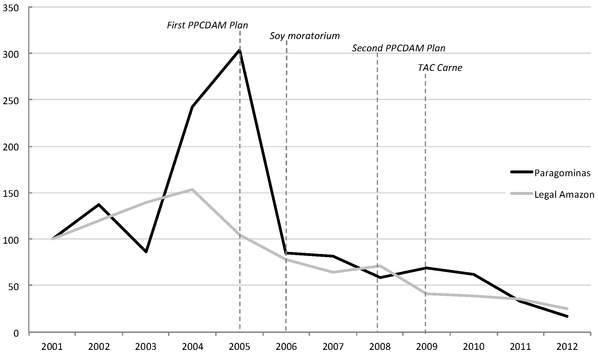
Between 2007 and 2008, as deforestation increased again (see
Figure 1), the Brazilian Federal Government published several important new decrees that significantly changed the responsibilities of stakeholders who shape land use change in the Amazon. Amongst them, a list of the main deforesting municipalities was created, with several restrictive measures imposed on them (
i.e., embargo, credit restrictions and fines for illegal activities) along with the definition of the conditions that had to be fulfilled to be removed from the list, viz. (i) to reduce deforestation to under 40 km2/year; (ii) annual deforestation of less than or equal to 60% of the average deforestation of the past two years; (iii) register 80% of the territory in the Rural Property Registry (CAR).
Figure 1.
Annual deforestation index in Paragominas and the Legal Amazon since 2001 (2001: base 100). Source: Adapted from PRODES data by the authors.
Figure 1.
Annual deforestation index in Paragominas and the Legal Amazon since 2001 (2001: base 100). Source: Adapted from PRODES data by the authors.
In 2008, Paragominas was added to the list of municipalities with the highest deforestation rates, and consequently faced strong pressure from federal and state agencies to reverse such trends. For example, two federal operations, labeled “Arc of Fire” and “Black Track”, were implemented and resulted in the closure of eight illegal sawmills and 120 illegal charcoal ovens, both of which had severe negative social and economic impacts [
7]. In this context, the municipality succeeded in getting most stakeholders to work towards a target of “zero deforestation” and “zero fire” that was even more ambitious than national goals, along with the registry of land properties in CAR to cover more than 80% of the territory. To make this happen, a pact was signed between representatives of the rural producer associations and civil society organizations. Some environmental NGOs (e.g., TNC, Imazon) were invited to provide technical assistance in support of efforts aimed at controlling deforestation and to implement CAR.
CAR cannot be done without the consent and cooperation of the landholder, because it implies entering the property to inspect existing land use. CAR became compulsory in 2008 in the State of Pará particularly as a pre-condition to obtain the Rural Environmental License (LAR). The CAR registers the boundaries of the landholding and reports the environmental situation of the property with respect to existing regulations (area of legal reserve, of permanent protection, etc.). The LAR testifies that the landholder is complying with existing environmental regulations, for example, has the required percentage of forested legal reserve. Although the municipality rapidly succeeded in completing the CAR for the major part of its territory, the process of Rural Environmental Licensing is much slower. According to the Environmental Secretary of Paragominas, only 25% of the landholdings currently have a LAR.
In 2014, a new environmental regulation was introduced at the municipal level, making it possible to compensate for the lack of legal reserve in other properties of the municipality without a formal and definitive land title. Indeed, the possibility to compensate for the absence of a legal reserve in every other property is permitted under the Forest Code. However, to benefit from such alternatives, the landholder needs a land title. In Paragominas, however, as in many other municipalities in the Brazilian Amazon, very few landholders have a definitive land title, and contrary to the expectations of local stakeholders, the process of land titling was not accelerated in the municipality even after the launching of the Green Municipality.
At the level of specific commodities (beef, soybean and timber), stakeholders have profited from the low production costs of the Amazon and have never been under pressure nor seen any advantage in engaging in any environmental commitment that would increase production costs. However, this situation started to change with the introduction of the Soy Moratorium in 2006 [
3]. Monitoring is conducted in all municipalities with more than 5000 ha of soybean, and consequently has been underway in Paragominas since its inception. When non-compliant firms regarding deforestation after 2006 are detected, they cannot sell their products and face credit restrictions the following year. Moreover, a Protocol was signed in 2014 in Paragominas by the main soybean traders, producers unions and public institutions of the government of the State of Para, in which traders pledged to check the legality of the soybean they purchased. Soybean traders thus committed themselves to go further than the zero-deforestation target of the Soy Moratorium and buy only soybean from landholders who have a CAR and are not on the list of properties under embargo by IBAMA nor involved in using slave labor.
A similar mechanism was imposed by the ministry to the livestock sector. Resulting from pressure from civil society and public institutions, in 2009, the biggest Brazilian beef companies Bertin, JBS, Minerva and Marfrig, but also the ABEG (bovine exports association) and supermarkets signed an individual Agreement for Adjustment of Conduct (AAC). The agreement stipulated that they would monitor their supplier, set up written contracts and conduct surveillance to ensure they were not implicated in either deforestation or slave labor. In addition to these individual agreements, a general agreement among producers, the beef industry, cattle ranchers associations and the government of Pará was also signed called the “TAC da Carne” (Agreement of Adjustment of Conduct for the beef sector). The CAR was also the instrument used to comply with the agreement, although the deadline for suppliers to complete the CAR was postponed several times. For example, between 2010 and 2011, the general agreement was adjusted more than five times. Finally, in April 2013, public prosecutors released a new agreement, the so-called “Cattle Agreement for the Amazon” that expands the initiative to other Brazilian states. The JBS was the first industry to sign this new agreement, which included some new clauses. First, the slaughterhouses have to check that their cattle suppliers are not on any list belonging to an environmental agency of a state and not only the list of IBAMA, which obliges them to extend their current monitoring system. Second, the public prosecutors decided to extend the deadlines in order to allow small-scale cattle suppliers more time to obtain both a CAR and an environmental license. According to the new agreement, the slaughterhouses have until May 2015 to demonstrate that their entire supply chain is legal, i.e., hold both a CAR certificate and an environmental license. Producers who do not sell cattle directly to the slaughterhouses, such as farmers who sell calves for fattening and dairy farmers, are not yet monitored through this Agreement. Thus, a large proportion of cattle and dairy farmers are not directly included in these agreements, especially smallholders.
In addition to these actions that have targeted the beef industry since 2007, other actors have introduced a process to define standards as a way to guide the whole supply chain. The International Finance Corporation (IFC) was responsible for the first steps to promote the creation of the Brazilian Working Group on Sustainable Beef (GTPS is its Portuguese acronym). The GTPS started in 2007 as an informal group of organizations representing producers, industry, NGOs and banks, with the idea that it could be a prototype for the Brazilian Sustainable Beef Roundtable. The expectation was that this group would further provide a multi-stakeholder governance mechanism similar to the Roundtable of Responsible Soy (RTRS) and Roundtable of Sustainable Palm Oil (RSPO). However, the GTPS did not advance by establishing standards or a code of conduct. According to GTPS reports, the producers and beef firms resisted the idea of developing standards or any sort of control imposed on the supply chain from outside. The beef firms preferred to adopt a strategy that would legitimize their own mechanisms for monitoring the supply chain, aligned to a commitment to meet the minimum criteria included in the Cattle Agreement. In the industry’s view, this already implies a significant effort to clean up its image in external markets. Indeed, there is no evidence that large international buyers (e.g., Sainsbury, Tesco, Burger King) are asking for stricter controls, and documented verification of legal practices is considered to be sufficient [
30].
All these mechanisms aim to guarantee the legal origin of production but during our surveys, only one positive incentive was mentioned aimed at promoting specific land use transitions in Paragominas. A Green Cattle program has been introduced in the municipality with large financial support from private foundations to implement management practices for pasture intensification and recovery, reforestation and animal welfare in six selected ranches. However this initiative is very limited, since it is being implemented in six ranches that have some of the best conditions to perform such high tech form of land use intensification. What is more, these ranches were already members of a best practice group, before the Green Cattle program in 2004. Based on our interviews, its replication in less favorable contexts will apparently be problematic because the technical package proposed is too complex and risky for a large-scale implementation.
4. Land Use Transitions in Paragominas
The following section presents the results obtained on land use transitions in Paragominas in answer to our three questions, viz. (i) Have all landholders succeeded in decreasing deforestation, thereby starting the transition to zero deforestation in the future? (ii) What is the biophysical potential of previously deforested areas? (iii) What are the main patterns of land use intensification and diversification since the beginning of the Green Municipality initiative?
4.1. Farm Size and the “Zero” Deforestation Target
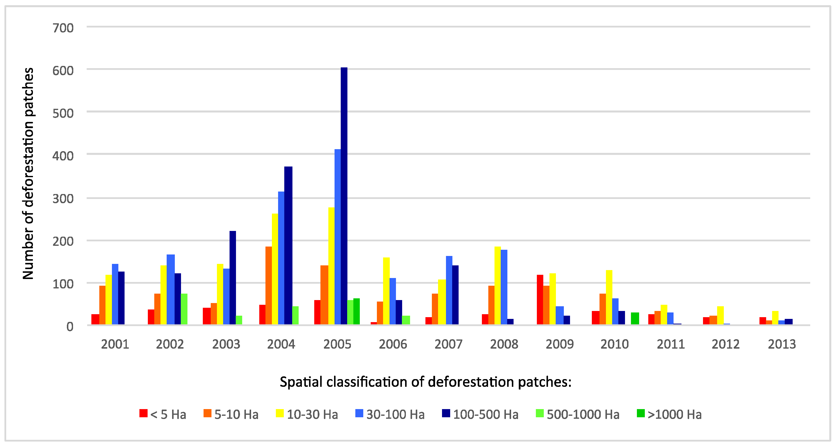
To assess if all landholders were succeeding in limiting deforestation, we linked deforestation patches to the properties to which they belong. The extension of annual deforestation patches is an indicator of the type of farmers responsible for deforestation.
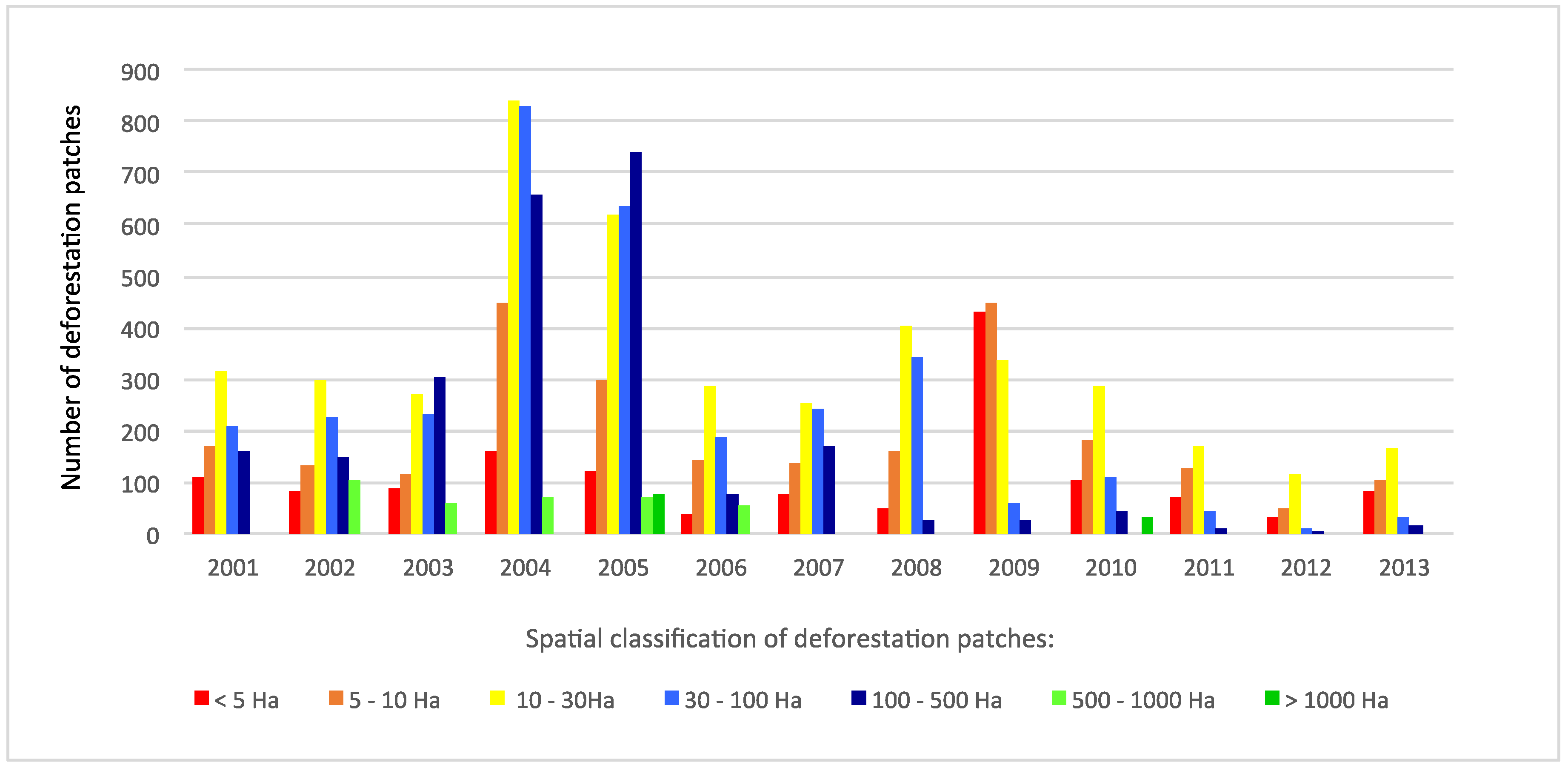
Figure 2 shows an increase in the proportion of small patches of deforestation over the last 12 years. Until 2005, deforestation was most frequently observed in large patches of more than 30 hectares, confirming the responsibility of medium and large-scale farmers. After 2005, the frequency of small patches increased while that of medium and large patches decreased. Small deforestation patches are not linked with a strategy by large and medium farmers to continue deforestation at a slower rate. As
Figure 3 indicates, these farmers, who are all registered in the CAR program, are not increasing deforestation in small patches, quite the contrary, they have clearly reduced all kinds of deforestation.
Figure 2.
Total number of deforestation patches as a function of spatial classes from 2001 to 2013. Source: Adapted from a public database by the authors (see
Section 2).
Figure 2.
Total number of deforestation patches as a function of spatial classes from 2001 to 2013. Source: Adapted from a public database by the authors (see
Section 2).
Figure 3.
Number of patches of deforestation located on medium and large farms as a function of spatial classes from 2001 to 2013. Source: Adapted from a public database by the authors (see
Section 2).
Figure 3.
Number of patches of deforestation located on medium and large farms as a function of spatial classes from 2001 to 2013. Source: Adapted from a public database by the authors (see
Section 2).
Some smallholders in Paragominas are located in the settlements created by the agrarian reform. Agrarian reform settlements account for only 5% of the total area of Paragominas, and are consequently not the main driver of land use changes, even if most smallholders still rely on slash and burn for their annual cropping. However,
Figure 4 indicates that the share of settlements in the total deforestation rate of the municipality is increasing significantly. Up to 2005, the deforested area in the settlements was high, with strong annual variations probably due to contextual factors such as the creation of new settlements or flows of migrants. However, deforestation was also very high outside settlements, as shown in
Figure 4. After 2005, there was a decline in the overall rate of deforestation, but the share of the settlements increased very rapidly, illustrating that the reduction in deforestation was more rapid outside settlements. In 2009, farmers in the settlements were responsible for 50% of the annual deforestation rate in the municipality. Their share fell in 2010, because a very large patch (2500 ha) was deforested, probably by one large landholder. In 2011 and 2012, the settlements’ share was still high, even though the municipal deforestation rate area declined, confirming the fact that deforestation is decreasing faster outside the agrarian reform settlements. In 2013, this situation was even worse with a significant increase in deforestation, in which the settlements’ share was more than 50%.
Figure 4.
Deforestation and agrarian reform settlements. Source: Adapted from a public database by the authors (see
Section 2).
Figure 4.
Deforestation and agrarian reform settlements. Source: Adapted from a public database by the authors (see
Section 2).
These results show that the governance mechanisms adopted have succeeded in decreasing deforestation in medium and large landholdings but have not succeeded in stopping deforestation in small landholdings. This has resulted in the increasing responsibility of agricultural settlements for the remaining deforestation in the municipality, which introduces a strong social dimension with respect to opportunities for different categories of farmer to engage in the land use transition.
4.2. Features and Potential of Deforested Areas in Paragominas
In a “zero-deforestation” context, the characteristics of open areas have major implications for future land use, profitability, and investments. From this perspective, soil quality plays a major role in the land use transition. Leaching is faster in sandy soils than in clayey soils. For this reason, clayey soils are preferred for mechanized annual cropping like soybean, corn or sorghum, and also for tree plantations. In eastern Amazon, clays are valued for their agronomic quality due to their higher cation exchange capacity [
32,
33].
Four types of soil texture are found in Paragominas linked with the topography: sand and clayey sand in the bottomlands in the plains and the valleys, mottled clay on the slopes of the valleys, gravel resulting from the dismantling of the duricrust on the convex edge of the plateaus, and clay on the plateaus. These soils are very acid, with a pH between 3.5 and 5.3 [
28]. Aluminum saturation is high: usually > 60%, which is the limit of toxicity. Organic carbon contents are low, ranging from 0.1 to 3.8% due to the rapid mineralization of organic matter. Concentrations of exchangeable bases are low, ranging from 0.2 to 1.5 cmole kg
−1, however, they are higher in the topsoil horizon of the clay on the plateaus (from 4.2 to 7.9 cmole kg
−1) than in sand and clayey sand (< 4 cmole kg
−1) [
32].
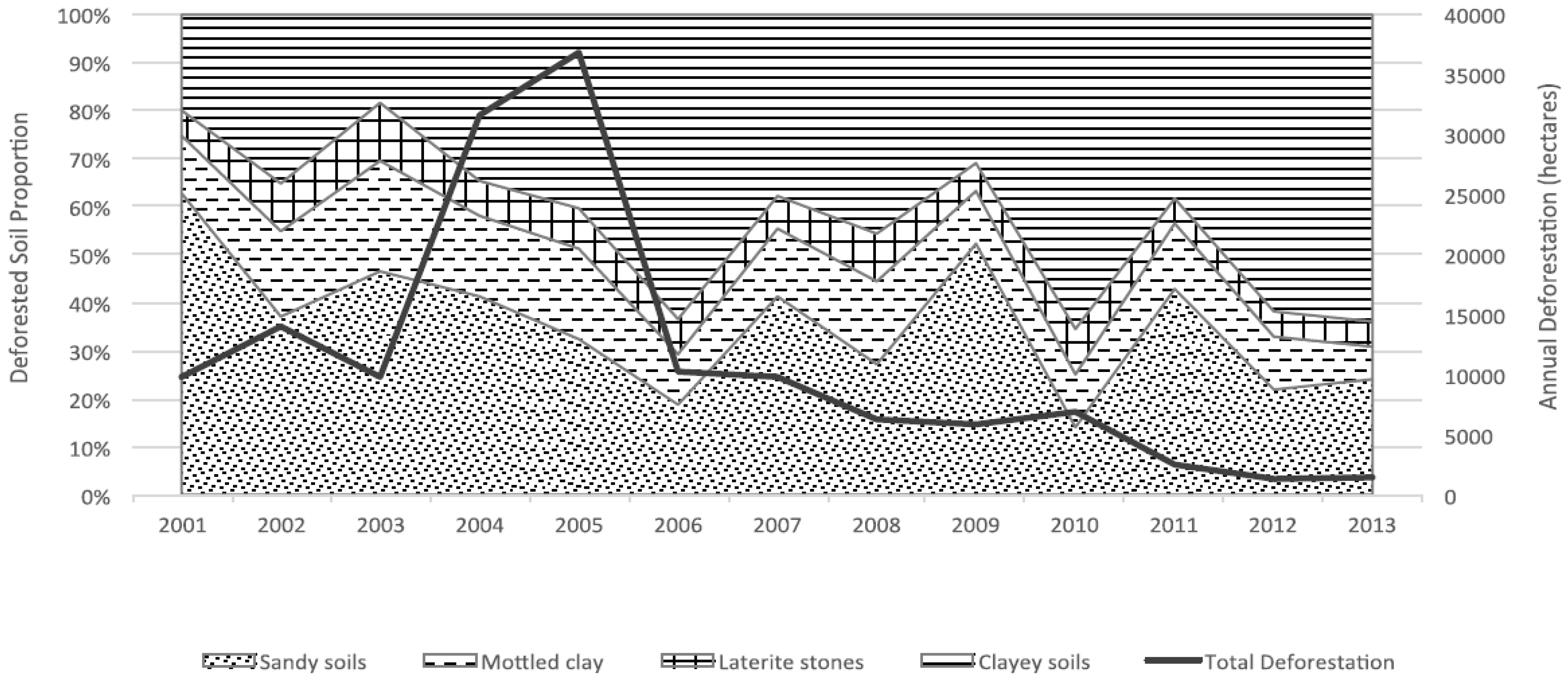
Map 1 and
Figure 5 clearly show that up to 2000, deforestation mostly occurred close to rivers, in sandy plains and valleys. Historically, the main proximate cause of deforestation in the territory has been to extend pasture for extensive cattle ranching [
34,
35]. Cattle ranching requires good access to surface waters (rivers and small streams), which are concentrated in the plains and valleys. Moreover, the low fertility of sandy soils does not have a negative effect on pasture productivity in these extensive systems.
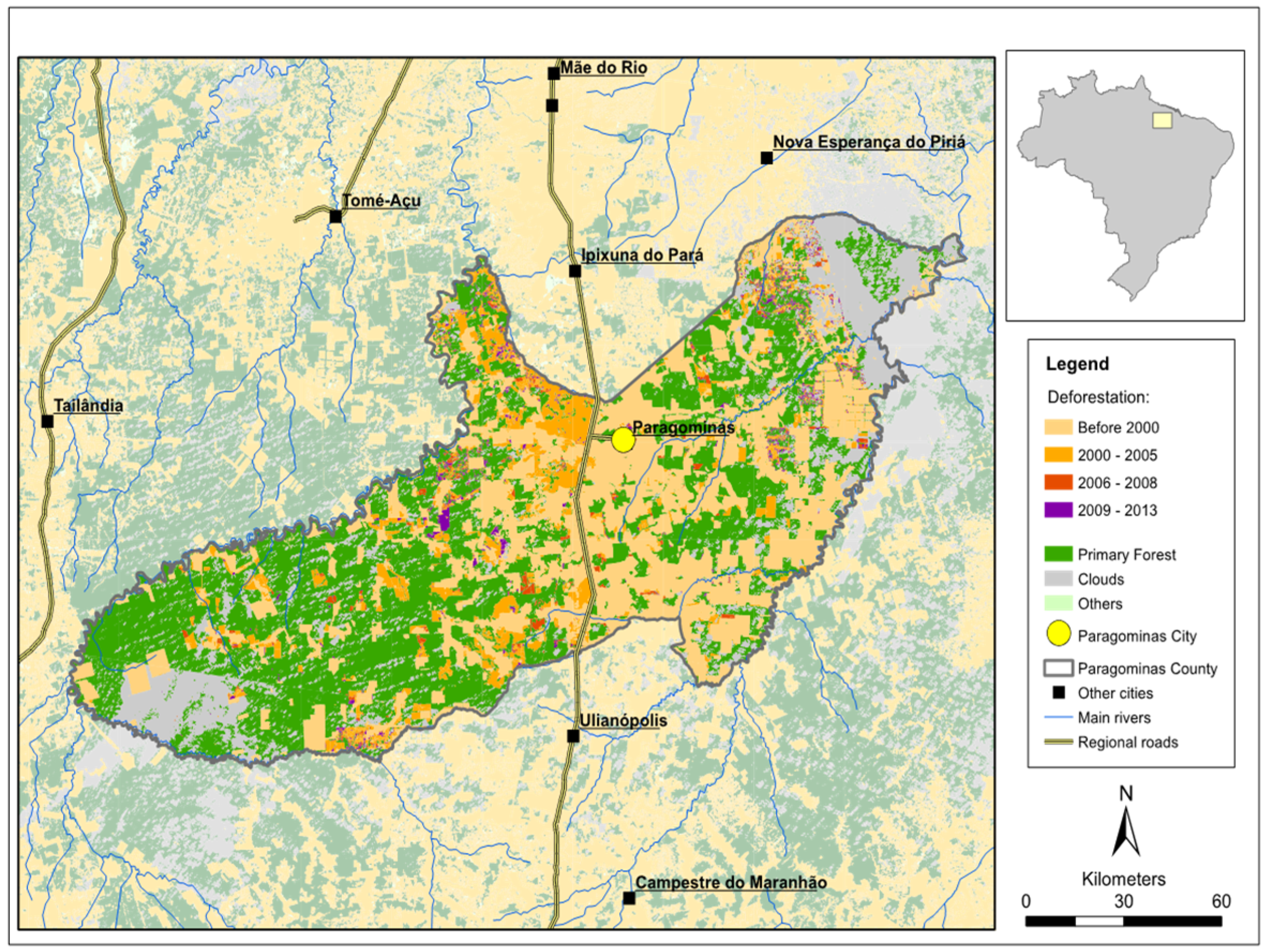
Map 1.
Location of deforestation in Paragominas 2000–2013.
Map 1.
Location of deforestation in Paragominas 2000–2013.
The share of deforested clay soils increased drastically particularly in the period 2001–2006, which coincides with the beginning of the expansion of soybean (
Figure 5). The share of clay soils increased from 30% to 70% of the area deforested each year, and triggered an agrarian transition from extensive cattle rearing to more intensive and diversified crop production.
Figure 5.
Distribution of annual deforested areas as a function of soils type from 2001–2013.
Figure 5.
Distribution of annual deforested areas as a function of soils type from 2001–2013.
Between 2006 and 2009, the monitoring reports of the soy moratorium did not detect soybean planted on land deforested after 2006 in Paragominas (all data are available on the website of Abiove). Remaining deforestation was not significantly linked with this sector, and
Figure 5 shows a higher proportion of deforestation on sandy soils.
After 2009, the Green Municipality commitments, the Soy Moratorium and the “TAC Carne” were in operation. Small deforestation patches can still be identified on Map 1 mainly on clay soils (
Figure 5). Reviewing the monitoring reports of the Soy Moratorium revealed that 1109 hectares of soybean were planted on previously deforested area.
When we look more closely at the spatial distribution of the quality of soil in deforested areas, we see that most of the deforested clay soils are located close to main roads (less than 20 km) and can thus more easily be converted into crop fields or tree plantations (if this has not already been done). In the rest of the territory, most of the deforested soils are mainly sandy, with poor capacities for cereal and tree crops (
Table 1).
Table 1.
Deforested areas linked with soil types and distance from a road in 2013.
Table 1.
Deforested areas linked with soil types and distance from a road in 2013.
| Type of soil | Inside road Buffer 20 km | Outside road Buffer |
|---|
| Clayey soils | Total (Ha) | 245,468 | 436,304 |
| Deforested (Ha) | 154,752 | 90,230 |
| Deforestation rate (%) | 63 | 21 |
| Mottled clay | Total (Ha) | 81,557 | 304,509 |
| Deforested (Ha) | 63,644 | 87,956 |
| Deforestation rate (%) | 78 | 29 |
| Laterite gravels | Total (Ha) | 40,358 | 132,109 |
| Deforested (Ha) | 30,241 | 34,815 |
| Deforestation rate (%) | 75 | 26 |
| Sandy soils | Total (Ha) | 148,313 | 766,940 |
| Deforested (Ha) | 127,758 | 390,688 |
| Deforestation rate (%) | 86 | 51 |
| Total | Total (Ha) | 515,696 | 1,639,861 |
| Deforested (Ha) | 376,394 | 603,690 |
| Deforestation rate (%) | 73 | 37 |
These results show that land use diversification is more closely linked with the quality of the soil and logistics than during the previous period, which saw the expansion of cattle ranching. Moreover, it shows that most deforested soils are sandy with less agronomic potential for agricultural intensification and diversification.
4.3. Land Use Transition in Paragominas since the Beginning of the Green Municipality
Based on the TERRACLASS database, the land use dynamics observed in Paragominas during 2008–2010 confirm the rapid expansion of mechanized agriculture and tree plantations after 2008. Neverthless, Paragominas still boasts a significant quantity of primary forest cover (55% of the total area, with a 1% decrease over the period 2008 to 2010). Pasture is still the main land use following deforestation. Cropping and tree plantations are expanding rapidly but also fallows (fallows are secondary forests that grow after clear cutting or that invade a degraded pasture or a crop), even if this increase may be due to difficulties of interpreting remotely sensed data (see TERRACLASS methodology) (
Table 2).
Table 2.
Land use dynamics in Paragominas between 2008 and 2010.
Table 2.
Land use dynamics in Paragominas between 2008 and 2010.
| Land use in hectares | 2008 | 2010 | % growth |
|---|
| Forest | 1,066,773 | 1,055,430 | −1 |
| Pasture | 366,606 | 404,763 | 10 |
| Secondary forest | 198,193 | 337,993 | 71 |
| Mechanized agriculture | 44,585 | 67,708 | 52 |
| Tree plantations | 724 * | 13,339 | NA |
| Deforestation in the year | 5,374 | 6,763 | 26 |
| Other | 13,175 | 16,736 | 27 |
| No data | 233,539 | 25,513 | −89 |
| Total | 1,928,245 | 1,928,245 | 0 |
The increase in mechanized agriculture and tree plantations is concentrated in areas located less than 20 km from main roads. This area accounts for 23% of the total area of the municipality, but concentrates 78% of agriculture, 73% of tree plantations and only 10% of primary forest (
Table 3).
Table 3.
Land use in the buffer area close to roads, Paragominas, 2010.
Table 3.
Land use in the buffer area close to roads, Paragominas, 2010.
| Land use in 2010 (hectares) | Total Municipality | Roads buffer (20 Km) |
|---|
| Hectares | % of total area |
|---|
| Forest | 1,055,430 | 105,774 | 10 |
| Pasture | 404,763 | 116,387 | 29 |
| Secondary forest | 337,993 | 138,592 | 41 |
| Mechanized Agriculture | 67,708 | 52,564 | 78 |
| Tree plantations | 13,339 | 9,742 | 73 |
| Deforestation 2010 | 6,763 | 289 | 4 |
| Other | 16,736 | 4,794 | 29 |
| No Data | 25,513 | 6,512 | 26 |
| Total | 1,928,245 | 434,654 | 23 |
Mechanized agriculture is expanding in productive pasture much more than on degraded and highly degraded pasture, as shown in
Table 4. In the case of tree plantation (
Table 4), this trend is not so clear with a higher proportion of trees planted on highly degraded pastures and secondary forests.
Table 4.
Land use changes due to agriculture expansion, 2008–2010.
Table 4.
Land use changes due to agriculture expansion, 2008–2010.
| Land use in 2008 | Location of agricultural expansion from 2008–2010 (%) | Location of tree plantation expansion, 2008–2010 (%) |
|---|
| Deforestation 2008 | 1 | 0 |
| Productive pasture | 55 | 30 |
| Degraded pasture | 11 | 8 |
| Highly degraded pasture | 1 | 7 |
| Secondary forest | 3 | 39 |
| Other | 1 | 9 |
| No Data (not observed) | 28 | 7 |
| Total | 100 | 100 |
The results confirm a rapid land use diversification mostly near main roads that cannot be strongly linked with the restoration of degraded pastures.
5. Discussion
A multi-level approach to land governance has emerged in the Brazilian Amazon with greater synergies between different levels of government (federal, state, municipal), and closer links between public and private actions. With regards to increasing government coordination, better and more targeted law enforcement has been implemented by the federal government leading to a more efficient and credible command-and-control system. At the state level, the government of the state of Pará became more active through the creation of the LAR and CAR, which were progressively introduced to the federal policy framework. At the municipal level, some federal and state legal frameworks have been adopted to take into consideration local specificities such as the municipal decree allowing forest compensation without formal land titles. Applied in Paragominas, this multi-level governance approach facilitated the achievement of ambitious targets for the reduction of deforestation, in the context of broader shifts in policy goals. However, it has not yet succeeded in triggering large scale land use intensification, reforestation and restoration of degraded lands. Some of the key challenges observed are discussed below.
Agriculture and tree plantations appear to have expanded mainly in good land quality areas, not degraded lands, and closer to the road network. New technologies for soil fertility management (using chemical fertilizers and liming), and new production systems for cereals (essentially soybean and maize) or tree plantations (eucalyptus and a native species,
Shizolobium amazonicum), require high investments and are much more profitable with clay soils [
34]. This may explain why farmers are cultivating the most appropriate soils (clay soils), which were mostly formerly productive pasture, more than degraded ones. In addition, the spatial overlay of productive pasture and crops are being progressively linked by the development of integrated crop-livestock systems, in which crops are cultivated for two or three years, after the mechanical and chemical destruction of invasive plants. Fertilization and liming of the crop improve the productivity of the following pasture for six years. This kind of integrated systems is emerging mainly on clay soils.
Outside these good quality areas, and given current zero deforestation targets, the conditions for land use intensification and diversification through cereal crops or timber plantations may be much more difficult and costly since deforested soils are mostly sandy. Most of the clay soils in Paragominas are still covered by forest. Positive incentives will be required to enable land use transitions and intensification in such areas. Post-deforestation governance mechanisms now need to focus on the financial, technical, and social barriers to land use intensification and diversification and more research is needed to increase the number of alternative production systems and to promote innovations.
Based on the data presented here, it is not yet possible to give a complete picture of the process of intensification of cattle ranching outside the most favorable areas of the Green Cattle Program. This is not affordable for a lot of landholders. Research is urgently needed to better assess the current conditions and alternatives for this sector whose most productive areas suffer from competition associated with the expansion of cropping and tree plantations.
What is more, the mechanisms introduced to enhance land use governance under a multi-level approach have failed to contain deforestation on small-scale farms, an issue also recently highlighted by other authors [
36]. Many smallholders feel that they have few alternatives to slash and burn practices for annual cropping [
37]. The fear of sanctions is not sufficient. New policies and incentives are needed to avoid social exclusion and to promote improved land uses and intensification in small landholdings.
In this context, one question that remains is whether the positive incentives for land use intensification, reforestation, and restoration of degraded lands will be adopted in the commodity chains or continue to rely on conventional policy instruments, or a combination of both. Commitments around some key commodity value chains such as the Soy Moratorium and more recently the Cattle Agreement can be powerful mechanisms to tackle forest conservation but they also have their limits. First, implementing a monitoring system for the beef meat chain is much more complex than for soybean because usually calves, young bulls and steers are not raised on the same landholding [
38,
39]. For these reasons, monitoring the impact of the whole chain by final buyers and a product-based certification would be rather difficult given the spatial dispersion of many suppliers of calves and young bulls and the current difficulties in implementing the CAR at regional scale. Moreover, as discussed in
Section 3, the development of such standards, or any sort of control imposed on the supply chain from outside, is not supported by major actors of the beef commodity chain. Having systematically postponed the deadline to complete the CAR in the Cattle Agreement, Brazilian public institutions appear to recognize that they are not yet equipped to implement land and environmental regularization at the regional scale. Thus, today, the commitments of the beef chain still remain at the minimum level.
The Soy Moratorium also has its own limits. Undeniably, the Soy Moratorium probably made it possible to limit deforestation after 2006. However, the Soy Moratorium is the sole commitment of the chain and many soybean producers do not comply with environmental regulations such as the forest code [
3]. Broader commitments have only recently started to emerge thanks to the requirement that soy producers are also registered through CAR.
In Paragominas, the negotiations between the mayor and the representatives of the productive sector succeeded in getting medium and large-scale landholders to accept the CAR. This is one of the main successes of the Green Municipality initiative, since most of these landholders were against this kind of commitment. The main limit of the initiative is that nothing has been done yet to transform the territorial attributes of the commodities produced into added value. Hence, there is no economic incentive to go further in terms of either intensification or environmental restoration. The CAR is only a first step to monitor deforestation but does nothing to guarantee that all landholders comply with environmental regulations. Moreover, most large landholders we interviewed argued that the CAR and zero deforestation targets were accepted because land titling would be accelerated. However land titling, a process depending mostly on institutions outside the municipality, has failed to advance up to now. Landholders claim that without a land title, it is impossible for them to invest in land use intensification or in forest restoration, even if some local regulations have recently been approved that lessen such constraints.
Can positive incentives be based on a set of territorial performance indicators? Despite the challenges that remain, the current mobilization of public and private institutions in Paragominas have proven to be very effective in getting removed from the public list of Amazonian municipalities responsible for the highest rates of deforestation. Some authors are starting to propose to transfer the positive incentives from the supply chain and public policies to municipalities who achieve, for example, an 80% reduction in deforestation below the 10-year average [
18]. Additional research is needed to assess if such a system could reduce monitoring costs, improve the attractiveness of the territory for private and public investments, and would be supported by institutions that are already effective and with well-established local links. Moreover, the system cannot be based only on a simple attribute such as the reduction of deforestation or a zero-deforestation target because, as previously shown, such an attribute does not guarantee a transition to sustainable land use, rural development or environmental restoration. Finally, the issue of possible leakage into other municipalities needs to be taken into account from the outset.
6. Conclusions
The Brazilian Amazon has undergone tremendous changes in the last ten years, with significant interplay between different levels of public and private governance mechanisms. In Paragominas, the first Green Municipality, the main results have been the “almost end” of deforestation and the registration in the rural property registry (CAR) of large and medium-scale farms. However, land use diversification and intensification continue to be limited to properties and areas with the best soil and logistical conditions with attendant risks of social exclusion of smallholders. The emerging multi-level governance mechanisms have not been sufficient to promote a broader transition to sustainable land uses, an agenda still essential for the future economic development of the Amazon. Research is urgently needed to increase the number of suitable production alternatives for the large, medium and small landholders to enable them all to ensure environmentally sustainable production systems for a zero-deforestation future.
Moreover, positive incentives to promote the transition are still rare and product-based standards for some commodities including beef, face strong challenges to be supported and implemented by most stakeholders. Successful partnerships between public, private, and civil entities at the territorial level may increase the chances of success for a hybrid governance model based on broader territorial attributes than simply a reduction in deforestation. Such certification of the territory would also increase its attractiveness for private investors and guide public incentives. Although it is too soon to define the exact attributes on which such a standard should be based, further research could help identify the indicators and methods to monitor changes in agricultural and ecological processes at the landscape level and to adapt existing certification systems.


